The Contested Cultural Landscape of a Lebanese Border Town: MARJA AYOUN
|
|
|
- Paul Conley
- 5 years ago
- Views:
Transcription

1 The Contested Cultural Landscape of a Lebanese Border Town: MARJA AYOUN IBD 2013 FNAS MAY 2013 Dr. Christine Mady, City & Regional Planning NDU -FAAD
2 In this Presentation A PLANNING PERSPECTIVE INTRODUCING THE CASE STUDY AREA THE SELECTED APPROACH ELEMENTS OF NATURE & CULTURE IN THE STUDY AREA CONCERNS AND RECOMMENDATIONS
3 A Planning Perspective Investigating the built environment through its architecture, and infrastructure; An integrated approach with a focus on the natural and built environments; Integration of people within the environment they live and work in under several influences: environmental, cultural, social, economic, political and so on.


4 Introducing Qaza Marja ayoun Up until 2000 was isolated from the rest of the country The need for integrating this region within the rest of the country, especially with the challenge of mined areas, and the preservation of the region s natural and cultural heritage Further damage in the area in 2006, but also further construction
5 INTEGRATED PLANNING APPROACH THE SELECTED APPROACH SELECTED FRAMEWORK DATA COLLECTION & ANALYSIS PRESERVATION RESTORATION CONSOLIDATION HERITAGE CULTURE FOCUS ON CULTURAL HERITAGE LANDSCA PE CASE STUDY AREA LANDSCAPE NPMPLT MULTI-FUNCTIONAL LANDSCAPES
6 The Selected Approach -- There is a constant struggle between nature and urbanisation. The invasive development of urban settlements and their services is not without limits. Natural landscapes could be reclaimed, restored, rehabilitated and expanded simply because they have been initially generated by human activities. However, it takes comprehensive management and social acceptance to reach such sustainable development.

7 Elements of Nature & Culture in the Study Area


8 Lebanon and the Previous Security Zone
9 The Qaza & Its Settlements Fig 1.5

10 Population Density

11 Land Cover


12 Study Area Borders SOUTHERN BORDER SOUTHERN JUNCTION EASTERN BORDER


13 Viewing the Study Area LITANI RIVER COURSE: Right Beaufort Fortress; left: Qlaya a, Marja ayoun and Bouwayda Going from Litani towards Marja ayoun


14 Marja ayoun General Views
15 GIS Analysis Geology & Hydro- Geology NATURAL PHYSICAL SETTING Soil and Land Cover Water Resources (ground & surface) Topography (elevation, slope, aspect) NATURAL LIVING ENVIRONMENT Flora Fauna THE BUILT ENVIRONMENT Settlements Infrastructure
16 GIS Analysis NATURAL PHYSICAL SETTING COMPOSITE MAPS NATURAL LIVING ENVIRONMENT THE BUILT ENVIRONMENT
17 Analysis -- Four major land cover categories: woodland (oak: Quercus coccifera and Quercus calliprinos; olive: Olea europa; pine: Pinus halepensis and Pinus pinea), orchards (vines, citrus trees, peaches, apricots, almonds, pistachio), open land (grassland, scrubland, bare rocks, dispersed trees) olive tree groves
18 Protected Green
 o Fault lines o Forests o roads")
19 Buffer around Natural Features Protected areas with buffers: o Water bodies (rivers/ springs) o Fault lines o Forests o roads

20 Protected All Categories

21 C u l t u r a l L a n d s c a p e Analytical study of settlements Relation of settlements to topography: mostly located on hill tops Settlements and land cover: mostly separated by woodland or open land Olive groves and orchards are used as buffers between fields and settlements Settlements expand along circulation axes or spines, with individual sporadic sprawl scattered in the vicinity of the urban agglomeration and infringing on field crops The river strip was initially covered with oak woods except for few patches of agricultural land


22 Urban Areas & Land Mines


23 Traditional Houses


24 Setting of Houses


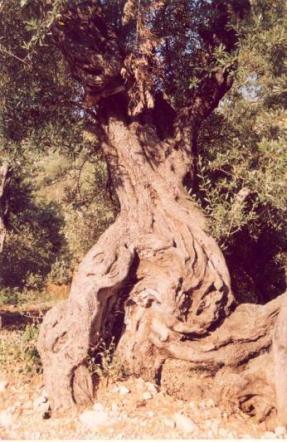
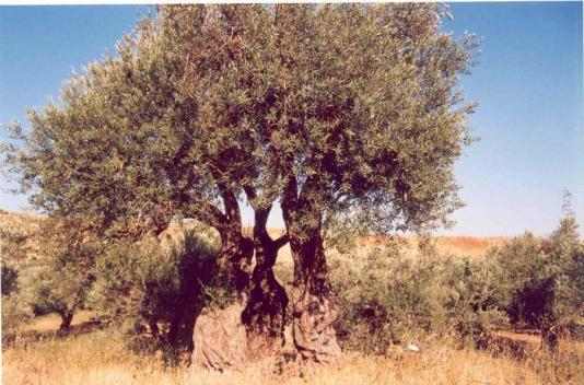
25 Governmental Buildings


26 Public Spaces


27 Dilapidated Houses


28 Streets


29 Advertisements
30 Heritage Sites


31 Heritage Sites


32 WWII


33 Olive Tree Groves


34 Renovated Houses
35 Cultural Heritage - Summary Importance of dealing with these sites goes beyond the boundaries of the study area Here, history is live through an ongoing vernacular lifestyle; Concrete construction has not yet mushroomed like in the rest of the country Religious buildings, market place, cemeteries and gardens as well as orchards still give the area its character and identity. These are cultural stepping stones that should be utilised to consolidate the area with the rest of the country.

36 Realisation

37 NPMPLT: Unity, Balance, Rationality
38 Urban Planning Framework Balance: Balance around urban centres Unity: National economic development plan; Social infrastructure; Transportation spine for stitching together the territories; Urban development respecting the character of each area NPMPLT Rationality: Value the natural resources; Use water resources in a sustainable manner; Resolve problems such as quarrying, waste water and solid waste disposal among others
39 Urban Planning Framework -- Unity: No linkages of natural areas in the CSA to the rest of the country; Integrating war afflicted spots and land within the landscape (only as UN initiative) Balance: Area as a sub-centre; Employment opportunities and incentives to invest in the area; Tourism potentials within the area; No development of social infrastructure; No strategy for keeping in the area its inhabitants, especially young people (aged 18-30) NPMPLT Rationality: No indication for reserves within the area; The role and impact of agriculture in the area; No guidelines for environmental protection; No active management of quarries; Waste water treatment and solid waste disposal; Use of renewable energy schemes


40 Concerns & Recommendations
41 Concerns & Recommendations Fragmentation and depletion of remaining woodland Replacing natural land with agriculture and construction Deterioration of the riparian systems in turn affecting the flora and fauna Loss of endemic species Change in road morphology affecting nature and scenes in the area Quarrying activities Fertilisers and pesticides adverse effects Lack of water management No control of human encroachment on habitats (construction, hunting, waste disposal, and so on) No planned social and economic development No management and conservation of heritage sites Proper documentation and generating inventories Restoration of already existing patch habitats Restoration of riparian environments Connectivity corridors Conservation of cultural heritage Linking environmentally and culturally significant sites Linking historical landscapes and human settlements, promoting their complementarity Upgrading agricultural methods Awareness campaigns on species Habitats for endangered species Regulatory framework and organisation Public participation and awareness Economic development, keeping inhabitants in their area


42 2005 and 2013
43 What next? Questions? Thank You!
The National Spatial Strategy
 Purpose of this Consultation Paper This paper seeks the views of a wide range of bodies, interests and members of the public on the issues which the National Spatial Strategy should address. These views
Declaration Population and culture
 Declaration Population and culture The ministers of the parties to the Alpine Convention regard the socio-economic and socio-cultural aspects mentioned in Article 2, Paragraph 2, Item a., as being central
CLLD Cooperation OFFER
 Title of the proposed project (English) CLLD Cooperation OFFER PARKS PROTECTION III - Management, Protection and Economic Development in Protected Areas Type of project (select as many as you want) Cooperation
Jordan's Strategic Research Agenda in cultural heritage
 Jordan's Strategic Research Agenda in cultural heritage Analysis of main results Alessandra Gandini Amman, Jordan 3 rd November 2013 Main objectives The work performed had the main objective of giving
Introduction to the Gozo & Comino Local Plan
 Introduction to the Gozo & Comino Local Plan What is a Local Plan? A Local Plan is a land use document with written text (policies and justifications) and maps; Reconciles local needs with strategic considerations;
Legal problems of environmental management. Spatial planning and space management. M. Gajewski 2014 / 2015
 Legal problems of environmental management Spatial planning and space management M. Gajewski 2014 / 2015 Course contents (in brief) Constitutional basis of the environment protection system. General principles
Belfairs Academy GEOGRAPHY Fundamentals Map
 YEAR 12 Fundamentals Unit 1 Contemporary Urban Places Urbanisation Urbanisation and its importance in human affairs. Global patterns of urbanisation since 1945. Urbanisation, suburbanisation, counter-urbanisation,
Making maps: Traditions and perceptions in Europe. European spatial planning and cartographic representations
 ESPON Create Europe! Making maps: Traditions and perceptions in Europe Dr. Stefanie Dühr University of the West of England, Bristol, UK European spatial planning and cartographic representations Scenarios.
Land Use in the context of sustainable, smart and inclusive growth
 Land Use in the context of sustainable, smart and inclusive growth François Salgé Ministry of sustainable development France facilitator EUROGI vice president AFIGéO board member 1 Introduction e-content+
DETERMINE OF REGIONAL DEVELOPMENT STRATEGIES IN IZMIR
 Sukran Yalpir Asli Bozdag Saban Inam DETERMINE OF REGIONAL DEVELOPMENT STRATEGIES IN IZMIR Globalization INTRODUCTION Economic pressure cause Economic migration cause cause Spatial organizations Spatial
Local Development Pilot Project: Island of Cres. Ranka Saračević Würth, Ministry of Culture, Republic of Croatia
 Local Development Pilot Project: Island of Cres Ranka Saračević Würth, Ministry of Culture, Republic of Croatia BACKGROUND, RATIFICATION OF THE FARO CONVENTION BY REPUBLIC OF CROATIA The Framework Convention
Community Engagement in Cultural Routes SiTI Higher Institute on Territorial Systems for Innovation Sara Levi Sacerdotti
 Transnational Workshop Wroclaw, 7th-8th December 2016 Community Engagement in Cultural Routes SiTI Higher Institute on Territorial Systems for Innovation Sara Levi Sacerdotti levi@siti.polito.it TAKING
16540/14 EE/cm 1 DG E 1A
 Council of the European Union Brussels, 5 December 2014 (OR. en) 16540/14 ENV 965 CULT 139 NOTE From: To: Subject: General Secretariat of the Council Delegations Charter of Rome on Natural and Cultural
CHAPTER 4 HIGH LEVEL SPATIAL DEVELOPMENT FRAMEWORK (SDF) Page 95
 Page 95") CHAPTER 4 HIGH LEVEL SPATIAL DEVELOPMENT FRAMEWORK (SDF) Page 95 CHAPTER 4 HIGH LEVEL SPATIAL DEVELOPMENT FRAMEWORK 4.1 INTRODUCTION This chapter provides a high level overview of George Municipality s
CHAPTER 4 HIGH LEVEL SPATIAL DEVELOPMENT FRAMEWORK (SDF) Page 95 CHAPTER 4 HIGH LEVEL SPATIAL DEVELOPMENT FRAMEWORK 4.1 INTRODUCTION This chapter provides a high level overview of George Municipality s
Bishkek City Development Agency. Urban Planning Bishkek
 Bishkek City Development Agency Urban Planning Bishkek Bishkek City Development Agency Official name City budget Population Area GRP Import value Export value External trade turnover Foreign direct investments
Tackling urban sprawl: towards a compact model of cities? David Ludlow University of the West of England (UWE) 19 June 2014
 19 June 2014") Tackling urban sprawl: towards a compact model of cities? David Ludlow University of the West of England (UWE) 19 June 2014 Impacts on Natural & Protected Areas why sprawl matters? Sprawl creates environmental,
Tackling urban sprawl: towards a compact model of cities? David Ludlow University of the West of England (UWE) 19 June 2014 Impacts on Natural & Protected Areas why sprawl matters? Sprawl creates environmental,
PURR: POTENTIAL OF RURAL REGIONS UK ESPON WORKSHOP Newcastle 23 rd November Neil Adams
 PURR: POTENTIAL OF RURAL REGIONS UK ESPON WORKSHOP Newcastle 23 rd November 2012 Neil Adams PURR: Potential of Rural Regions Introduction Context for the project A spectrum of knowledge Rural Potentials
Measuring Disaster Risk for Urban areas in Asia-Pacific
 Measuring Disaster Risk for Urban areas in Asia-Pacific Acknowledgement: Trevor Clifford, Intl Consultant 1 SDG 11 Make cities and human settlements inclusive, safe, resilient and sustainable 11.1: By
INTERNATIONAL CULTURAL TOURISM CHARTER Managing Tourism at Places of Heritage Significance (1999)
") INTERNATIONAL CULTURAL TOURISM CHARTER Managing Tourism at Places of Heritage Significance (1999) Adopted by ICOMOS at the 12th General Assembly in Mexico, October 1999. INTRODUCTION The Charter Ethos
INTERNATIONAL CULTURAL TOURISM CHARTER Managing Tourism at Places of Heritage Significance (1999) Adopted by ICOMOS at the 12th General Assembly in Mexico, October 1999. INTRODUCTION The Charter Ethos
Programs Aligned With: Kindergarten Social Studies
 Programs Aligned With: Kindergarten Social Studies Progressive Waste Solutions K.2.1 Compare and contrast children and families today with those in the past using various sources K.3.2 Identify maps and
Topic 4: Changing cities
 Topic 4: Changing cities Overview of urban patterns and processes 4.1 Urbanisation is a global process a. Contrasting trends in urbanisation over the last 50 years in different parts of the world (developed,
Land Use Planning and Agriculture: Austrian Experiences and Challenges I
 Land Use Planning and Agriculture: Austrian Experiences and Challenges I SULANET Summer School 2016 Walter Seher BOKU Vienna 1 Land Use Planning and Agriculture 2 Land Use Planning and Agriculture Agriculture
HSC Geography. Year 2013 Mark Pages 10 Published Jul 4, Urban Dynamics. By James (97.9 ATAR)
") HSC Geography Year 2013 Mark 92.00 Pages 10 Published Jul 4, 2017 Urban Dynamics By James (97.9 ATAR) Powered by TCPDF (www.tcpdf.org) Your notes author, James. James achieved an ATAR of 97.9 in 2013 while
HSC Geography Year 2013 Mark 92.00 Pages 10 Published Jul 4, 2017 Urban Dynamics By James (97.9 ATAR) Powered by TCPDF (www.tcpdf.org) Your notes author, James. James achieved an ATAR of 97.9 in 2013 while
Riga. Riga City Planning Region. Legal framework
 Riga http://www.rpr.gov.lv/ Riga City Planning Region Riga Planning Region as a territory is situated in the central part of Latvia, and its centre is Riga - the capital of Latvia. Riga is internationally
Chapter 14 The technical role of government authorities in watershed management
 Chapter 14 The technical role of government authorities in watershed management 14.1 Objectives and procedural outline 1) Purpose of this chapter as related to participatory watershed management The participatory
THE IMPACT OF LANDSLIDE AREAS ON MUNICIPAL SPATIAL PLANNING
 THE IMPACT OF LANDSLIDE AREAS ON MUNICIPAL SPATIAL PLANNING Jarosław Bydłosz, PhD Faculty of Mining Surveying and Environmental Engineering AGH University of Science and Technology e-mail: bydlosz@agh.edu.pl
Socials Studies. Chapter 3 Canada s People 3.0-Human Geography
 Socials Studies Chapter 3 Canada s People 3.0-Human Geography Physical Geography Study of the natural features of the Earth s surface including landforms, climate, ocean currents and flora and fauna Human
TERRITORIAL IMPACT ASSESSMENT: AN APPROACH TO IMPROVE THE VERTICAL AND HORIZONTAL INTEGRATION OF EU POLICIES
 TERRITORIAL IMPACT ASSESSMENT: AN APPROACH TO IMPROVE THE VERTICAL AND HORIZONTAL INTEGRATION OF EU POLICIES Naja Marot & Mojca Golobič Biotehnical Faculty, University of Ljubljana, Slovenia RSA Workshop
5 th DRAFT OF THE ICOMOS CHARTER ON CULTURAL ROUTES (September, 2005)
") 1 5 th DRAFT OF THE ICOMOS CHARTER ON CULTURAL ROUTES (September, 2005) Working document presented for discussion at the 15 th GA in China in view of further comments and eventual adoption at the 16 th
1 5 th DRAFT OF THE ICOMOS CHARTER ON CULTURAL ROUTES (September, 2005) Working document presented for discussion at the 15 th GA in China in view of further comments and eventual adoption at the 16 th
National Spatial Development Perspective (NSDP) Policy Coordination and Advisory Service
 Policy Coordination and Advisory Service") National Spatial Development Perspective (NSDP) Policy Coordination and Advisory Service 1 BACKGROUND The advances made in the First Decade by far supersede the weaknesses. Yet, if all indicators were
National Spatial Development Perspective (NSDP) Policy Coordination and Advisory Service 1 BACKGROUND The advances made in the First Decade by far supersede the weaknesses. Yet, if all indicators were
CONFERENCE STATEMENT
 CONFERENCE STATEMENT We, the elected representatives from Canada, Denmark/Greenland, Finland, Iceland, Norway, Russia, Sweden and the United States of America; In collaboration with the indigenous peoples
Navigable maritime and river waterways in the seaside - Danube Delta area and the connected rural development
 SUMMARY OF Ph-D Thesis, with title RESEARCH STUDIES ON MANAGEMENT IMPROVEMENT OF MARITIME AND RIVER TRANSPORT ACTIVITY IN THE COASTAL AND DANUBE DELTA AREA FROM AN ENVIROMENTAL, ECONOMIC AND SOCIAL PERSPECTIVE
The UN-GGIM: Europe core data initiative to encourage Geographic information supporting Sustainable Development Goals Dominique Laurent, France
 INSPIRE conference Strasbourg 6 September 2017 The UN-GGIM: Europe core data initiative to encourage Geographic information supporting Sustainable Development Goals Dominique Laurent, France Introduction
Vital city lively neighborhood living center
 From the ugliest place to heart of the suburb Vital city lively neighborhood living center Marja Straver - Nevalainen September 12 th, 2012 If you want to see the sun, t th look next to it to NL FI 10x
Transition factors analysis of human settlement
 The Sustainable City VI 53 Transition factors analysis of human settlement S.-T. Kuo & Ch.-J. Chen Graduate Institute of Urban Development and Architecture, National University of Kaohsiung, Taiwan Abstract
Coastal Environment. Introduction. 4.1 Coastal Environment. Extent of Coastal Environment
 4 The primary objective (set out in Chapter 2) to be implemented by this Chapter is Objective 2.4 ; the following objectives are also relevant due to the objectives integrated nature: 2.1 Tāngata whenua
Spatial profile of three South African cities
 Spatial Outcomes Workshop South African Reserve Bank Conference Centre Pretoria September 29-30, 2009 Spatial profile of three South African cities by Alain Bertaud September 29 Email: duatreb@msn.com
Vienna urban development - seestadt aspern as urban future lab
 Vienna urban development - seestadt aspern as urban future lab PERMACULTURE DESIGN COURSE * 2012 * ASPERN SEESTADT 1 Christof Schremmer, ÖIR Austrian Institute for Regional Studies and Spatial Planning
PROMOTING NATURE CONSERVATION AND SUSTAINABLE AGRICULTURAL DEVELOPMENT IN THE RURAL AREAS OF HONG KONG
 1 PROMOTING NATURE CONSERVATION AND SUSTAINABLE AGRICULTURAL DEVELOPMENT IN THE RURAL AREAS OF HONG KONG Director of Agriculture, Fisheries and Conservation Dr. LEUNG Siu-fai A STONE S THROW AWAY FROM
2017 HSC Geography Marking Guidelines
 2017 HSC Geography Marking Guidelines Section I Multiple-choice Answer Key Question Answer 1 D 2 D 3 B 4 A 5 D 6 B 7 B 8 A 9 C 10 C 11 D 12 C 13 C 14 D 15 B 16 D 17 A 18 C 19 A 20 C 1 Section II Question
Application for Geotourism Charter
 Application for Geotourism Charter Thank you for the interest in geotourism as a long-term strategy to foster wisely managed tourism and enlightened destination stewardship. National Geographic s Center
TOWARDS STRATEGIC SPATIAL PLANNING IN JAMAICA: THE NATIONAL SPATIAL PLAN
 TOWARDS STRATEGIC SPATIAL PLANNING IN JAMAICA: THE NATIONAL SPATIAL PLAN JIEP 5th Biennial Conference on the Environment: Balancing National Development and Environmental Protection June 6, 2011 Jamaica
PROTOCOL ON THE IMPLEMENTATION OF THE ALPINE CONVENTION OF 1991 RELATING TO SPATIAL PLANNING AND SUSTAINABLE DEVELOPMENT
 PROTOCOL ON THE IMPLEMENTATION OF THE ALPINE CONVENTION OF 1991 RELATING TO SPATIAL PLANNING AND SUSTAINABLE DEVELOPMENT SPATIAL PLANNING AND SUSTAINABLE DEVELOPMENT" PROTOCOL Preamble The Republic of
The ESPON Programme. Goals Main Results Future
 The ESPON Programme Goals Main Results Future Structure 1. Goals Objectives and expectations Participation, organisation and networking Themes addressed in the applied research undertaken in ESPON projects
AP Human Geography Syllabus
 AP Human Geography Syllabus Textbook The Cultural Landscape: An Introduction to Human Geography. Rubenstein, James M. 10 th Edition. Upper Saddle River, N.J.: Prentice Hall 2010 Course Objectives This
PLANNING FOR SUSTAINABILITY IN SLOVENIAN TOWNS
 Int. Journal for Housing Science, Vol.31, No.3 pp 205-214, 2007 Published in the United States PLANNING FOR SUSTAINABILITY IN SLOVENIAN TOWNS Mojca Sasek Divjak Urban Planning Institute of the Republic
Measurement of the Urban-Housing Deficit:
 Measurement of the Urban-Housing Deficit: Strategies, tools and sources of information The International Network for Urban and Regional Statistics Standing Committee of the International Association for
DEPARTMENT OF GEOGRAPHY B.A. PROGRAMME COURSE DESCRIPTION
 DEPARTMENT OF GEOGRAPHY B.A. PROGRAMME COURSE DESCRIPTION (3 Cr. Hrs) (2340100) Geography of Jordan (University Requirement) This Course pursues the following objectives: - The study the physical geographical
Cultural Routes of the Council of Europe - Glossary
 Cultural Routes of the Council of Europe - Glossary Below is a collection of terms linked to Cultural Routes of the Council of Europe. The glossary is taken from the book Cultural Routes management: from
Integrated Infrastructure Planning & Spatial Mapping
 Integrated Infrastructure Planning & Spatial Mapping Presenter: Heidi Dixon, Principal Social Planner, DTPLI 23 May 2014 PART 1 PLAN MELBOURNE : Metropolitan Planning Strategy PART 2 Case Study: DTPLI
Assessment of Sustainable Land Use within the Town Planning Process Experiences with a Multi Criteria Approach (MCA)
") Assessment of Sustainable Land Use within the Town Planning Process Experiences with a Multi Criteria Approach (MCA) Dipl.-Geogr. Sophie Schetke Dipl.-Ing. Benedikt Frielinghaus, University of Bonn, Germany
Assessment of Sustainable Land Use within the Town Planning Process Experiences with a Multi Criteria Approach (MCA) Dipl.-Geogr. Sophie Schetke Dipl.-Ing. Benedikt Frielinghaus, University of Bonn, Germany
Urbanization and Sustainable Development of Cities: A Ready Engine to Promote Economic Growth and Cooperation
 Urbanization and Sustainable Development of Cities: A Ready Engine to Promote Economic Growth and Cooperation Wan Portia Hamzah Institute of Strategic and International Studies (ISIS) Malaysia 10 September
Most people used to live like this
 Urbanization Most people used to live like this Increasingly people live like this. For the first time in history, there are now more urban residents than rural residents. Land Cover & Land Use Land cover
State initiative following up the 2006 national planning report
 18 ness districts and public institutions, should be integrated with the opportunities for public transport services. State initiative following up the 2006 national planning report The Ministry of the
Land Accounts - The Canadian Experience
 Land Accounts - The Canadian Experience Development of a Geospatial database to measure the effect of human activity on the environment Who is doing Land Accounts Statistics Canada (national) Component
The importance of visioning in urban strategic planning By Peter Robinson. MILE Master Class Urban Strategic Planning March 2016
 The importance of visioning in urban strategic planning By Peter Robinson MILE Master Class Urban Strategic Planning March 2016 Typical strategic planning process Where are we now? Where are we going?
Dutch spatial planning: from implicit to explicit sustainable urban development
 Dutch spatial planning: from implicit to explicit sustainable urban development Jan Goedman (VROM*) Wim Heiko Houtsma (VROM) Wil Zonneveld (Delft University) *Dutch Ministry of Housing, Spatial Planning
ENVIRONMENTALLY ORIENTED PLANNING FOR HUMAN SETTLEMENTS
 40 TOPIC 7 ENVIRONMENTALLY ORIENTED PLANNING FOR HUMAN SETTLEMENTS Scope The process of rapid population growth and urbanization taking place in practically all the less developed countries will have an
The Governance of Land Use
 The planning system Levels of government and their responsibilities The Governance of Land Use COUNTRY FACT SHEET NORWAY Norway is a unitary state with three levels of government; the national level, 19
Geography - Grade 8. Unit A - Global Settlement: Patterns and Sustainability
 Geography - Grade 8 Geographical Thinking: Spatial Significance Patterns and Trends Interrelationships Geographic Perspective Geographic Inquiry: STEP 1 - Formulate Questions STEP 2 - Gather and Organize
THE SEVILLE STRATEGY ON BIOSPHERE RESERVES
 THE SEVILLE STRATEGY ON BIOSPHERE RESERVES 1 VISION FOR BIOSPHERE RESERVES IN THE 21 ST CENTURY The international Seville Conference on Biosphere Reserves, organised by UNESCO, adopted a two-pronged approach,
Together towards a Sustainable Urban Agenda
 Together towards a Sustainable Urban Agenda The City We (Youth) Want Preliminary findings from youth consultations Areas Issue Papers Policy Units 1.Social Cohesion and Equity - Livable Cities 2.Urban
THE SEVILLE STRATEGY FOR BIOSPHERE RESERVES BIOSPHERE RESERVES: THE FIRST TWENTY YEARS
 THE SEVILLE STRATEGY FOR BIOSPHERE RESERVES BIOSPHERE RESERVES: THE FIRST TWENTY YEARS Biosphere reserves are designed to deal with one of the most important questions the World faces today: How can we
European Landscape Convention in the Slovak Republic
 13th COUNCIL OF EUROPE MEETING OF THE WORKSHOPS FOR THE EUROPEAN LANDSCAPE CONVENTION European Landscape Convention in the Slovak Republic Mrs. Ida Vanáková, state advisor, Department of Spatial Planning
Mediterranean Sea and Territorial Development, Opportunities and Risks
 EESC Hearing Towards an EU Macro-Regional Strategy for the Mediterranean Mediterranean Sea and Territorial Development, Opportunities and Risks Michaela Gensheimer Structure of Intervention Part I: What
Mitigating the human-elephant conflict in Sri Lanka: lessons from Southern Africa
 Mitigating the human-elephant conflict in Sri Lanka: lessons from Southern Africa Sanjay Kalpage 7 th International Wildlife Ranching Symposium Kimberly, South Africa, 11 th October, 2011 1 Overview Sri
THE USE OF GEOMATICS IN CULTURAL HERITAGE AND ARCHAEOLOGY FOR VARIOUS PURPOSES
 THE USE OF GEOMATICS IN CULTURAL HERITAGE AND ARCHAEOLOGY FOR VARIOUS PURPOSES FEBRUARY 2013 AL BEIDA GEOPLAN CONTENT Company Profile Concept Objectives and Strategies Data Production Methods Data Samples
Asia Pacific Ministerial Conference on Housing and Urban Development (APMCHUD) Meeting of the Working Group on Urban and Rural Planning and Management
 Meeting of the Working Group on Urban and Rural Planning and Management") Asia Pacific Ministerial Conference on Housing and Urban Development (APMCHUD) Meeting of the Working Group on Urban and Rural Planning and Management August 16 17, 2012 New Delhi Recommendations of the
Asia Pacific Ministerial Conference on Housing and Urban Development (APMCHUD) Meeting of the Working Group on Urban and Rural Planning and Management August 16 17, 2012 New Delhi Recommendations of the
EUROPEAN DIPLOMA-HOLDING AREAS AND THE GEOPARK INITIATIVE IN HUNGARY
 dr. Rozalia Szekeres Erdine, dr. Annamaria Kopek, Gyorgy Dudas, Jozsef Vers and Imre Szarvas EUROPEAN DIPLOMA-HOLDING AREAS AND THE GEOPARK INITIATIVE IN HUNGARY Ipolytarnóc Novohrad-Nógrád Geopark Tihany
Minnesota K-12 Academic Standards in Social Studies. Grade 4: Geography of North America
 Minnesota K-12 Academic s in Social Studies Grade 4: Geography of North America 4 Describe how people take 1. Democratic government action to influence a depends on informed and decision on a specific
Sustainable tourism in for Sustaibale Danang
 Sustainable tourism in for Sustaibale Danang A case study of Balearic Ecotax in Spain toward Sustainable tourism Miki Yoshizumi Associate Professor College of Gastronomy Management Ritsumeikan University
CLAREMONT MASTER PLAN 2017: LAND USE COMMUNITY INPUT
 Planning and Development Department 14 North Street Claremont, New Hampshire 03743 Ph: (603) 542-7008 Fax: (603) 542-7033 Email: cityplanner@claremontnh.com www.claremontnh.com CLAREMONT MASTER PLAN 2017:
MEETING THE CHALLNAGE OF THE URBAN RURAL DIVIDE MAG. SLAVKA ZUPAN
 MEETING THE CHALLNAGE OF THE URBAN RURAL DIVIDE MAG. SLAVKA ZUPAN Urban millenium (Source: GTZ- Services for Sutainable Urban Development))! Today 3 billion of people lives in towns and cities! Every day
(CDR) Contact: Dr. Wafa Sharaf el Dine Mr. Sami Feghali. Council for Development and Reconstruction
 Contact: Dr. Wafa Sharaf el Dine Mr. Sami Feghali. Council for Development and Reconstruction") Public Disclosure Authorized Public Disclosure Authorized Project Name Region Sector Project ID Borrower Implementing Agency Environmental Category Report No. PID8098 Lebanon-Cultural Heritage and Tourism...
Public Disclosure Authorized Public Disclosure Authorized Project Name Region Sector Project ID Borrower Implementing Agency Environmental Category Report No. PID8098 Lebanon-Cultural Heritage and Tourism...
Advancing Geoscientific Capability. Geological Survey of Finland
 Advancing Geoscientific Capability Geological Survey of Finland GTK in brief The Geological Survey of Finland (GTK) is one of the largest European centres of excellence in assessment, research and the
Department of Geography: Vivekananda College for Women. Barisha, Kolkata-8. Syllabus of Post graduate Course in Geography
 India: Regional Problems and Resource management Module 11 (Full Marks 50) Unit I: Region and Regionalisation 1.1 Various bases of regionalisation of India; problems of identification and delineation.
Natura 2000 and spatial planning. Executive summary
 Natura 2000 and spatial planning Executive summary DISCLAIMER The information and views set out in this study are those of the author(s) and do not necessarily reflect the official opinion of the Commission.
Least-Cost Transportation Corridor Analysis Using Raster Data.
 Least-Cost Transportation Corridor Analysis Using Raster Data What is GeoMedia Grid: Key Grid Concepts Vector Model Vector based systems show data by means of a series of points, lines, and polygons. Each
Spatial Planning and Territorial Development at the Regional Level
 Spatial Planning and Territorial Development at the Regional Level Vincent Nadin University of the West of England, UK Spatial Planning and Territorial Development at the Regional Level Vincent Nadin University
CEMAT results - over the years
 CEMAT results - over the years Technical Conference on Functional Areas capitalization of local potential within the territorial development policies in Europe European Conference of Ministers responsible
Catarina Capela Elisabete Figueiredo Cândido Pinto Diogo Soares da Silva
 Catarina Capela catarinacapela@ua.pt Elisabete Figueiredo elisa@ua.pt Cândido Pinto candidomanuel@ua.pt Diogo Soares da Silva diogo.silva@ua.pt University of Aveiro Portugal Discuss the reconfiguration
Sustainable development of the Greek islands
 Sustainable development of the Greek islands Coccossis H. in Camarda D. (ed.), Grassini L. (ed.). Interdependency between agriculture and urbanization: Conflicts on sustainable use of soil and water Bari
CAMP SLOVENIA. Mezek Slavko RRC Koper. Project coordinator November 2005
 CAMP SLOVENIA Mezek Slavko RRC Koper Project coordinator November 2005 http://camp.rrc-kp.si/ Content About MAP CAMP programme CAMP Slovenia Project background CAMP Slovenia Project area CAMP Slovenia
Chapter 10 Human Settlement Geography Book 1 Class 12
 CHAPTER 10 HUMAN SETTLEMENTS 1. RURAL, SUB URBAN AND URBAN SETTLEMENTS: This classification is common worldwide but the criteria differ from country to country. 5. Criteria for classification differs from
GEOGRAPHY. ATAR course examination, Question/Answer booklet. Time allowed for this paper Reading time before commencing work:
 ATAR course examination, 2017 Question/Answer booklet GEOGRAPHY Please place your student identification label in this box Student number: In figures In words Time allowed for this paper Reading time before
The purpose of this paper is to explain the concept
 THE INTER-DIMENSIONAL ANALYSIS OF URBAN DEVELOPMENT: A Guide to the Organisation of Cases and Their Linkages by Michael Safier Development Planning Unit (DPU) University College London Michael Safier 2001
EXPERT ANALYSIS ON GEOGRAPHICAL SPECIFICITIES
 EXPERT ANALYSIS ON GEOGRAPHICAL SPECIFICITIES Mountains, Islands and Sparsely Populated Areas Dr. Gilda Carbone 9 Oct 2018 Objectives: to gather basic information from relevant programming documents (PAs,
Disaster Prevention and Management in Asia: The Context of Human Security and Its Relevance to Infrastructure Planning and Management
 Disaster Prevention and Management in Asia: The Context of Human Security and Its Relevance to Infrastructure Planning and Management Rajib Shaw http://www.iedm.ges.kyoto-u.ac.jp/ Contents Background and
Developing urban ecosystem accounts for Great Britain. Emily Connors Head of Natural Capital Accounting Office for National Statistics (UK)
") Developing urban ecosystem accounts for Great Britain Emily Connors Head of Natural Capital Accounting Office for National Statistics (UK) UN 2014 UN 2014 ONS 2017 UK motivation 54% 82% 5,900 Of the world
Developing urban ecosystem accounts for Great Britain Emily Connors Head of Natural Capital Accounting Office for National Statistics (UK) UN 2014 UN 2014 ONS 2017 UK motivation 54% 82% 5,900 Of the world
The European territory: Strategic developmentd
 The European territory: Strategic developmentd Peter Mehlbye Workshop Strategic Development Catalonia 11 June 2002 THE LECTURE Structure I. Territorial trends II. Strategy for European spatial development
STUDY ON SPATIAL CULTURAL HERITAGE INTEGRATED INTO THE CORE CURRICULUM
 STUDY ON SPATIAL CULTURAL HERITAGE INTEGRATED INTO THE CORE CURRICULUM Wen-Huay Hsu a *,Yu-Peng Lai b a Dept. of Construction and Spatial Design, Tungnan University, No.152, Section 3, Beishen Rd., Shenkeng
GIS AND REMOTE SENSING FOR OPEN SPACE PROTECTION ENVIRONMENTAL MANAGEMENT DEPARTMENT
 GIS AND REMOTE SENSING FOR OPEN SPACE PROTECTION ENVIRONMENTAL MANAGEMENT DEPARTMENT 22 nd May 2009 1 Introduction It is said that more than 80% of the City s activities throughout the world are spatially
Ecological Land Cover Classification For a Natural Resources Inventory in the Kansas City Region, USA
 Ecological Land Cover Classification For a Natural Resources Inventory in the Kansas City Region, USA by Applied Ecological Services, Inc. In cooperation with the Mid-America Regional Council 600 Broadway,
Rural Gentrification: Middle Class Migration from Urban to Rural Areas. Sevinç Bahar YENIGÜL
 'New Ideas and New Generations of Regional Policy in Eastern Europe' International Conference 7-8 th of April 2016, Pecs, Hungary Rural Gentrification: Middle Class Migration from Urban to Rural Areas
COSTA RICA Limon City-Port Project
 photos by Stefania Abakerli COSTA RICA Limon City-Port Project 2008 2013 Cecilia Corvalan William Reuben Stefania Abakerli Background Request from GoCR following Caldera-Port Concession Reform Since the
Assessment Objectives Grid for Geography - G1. Summer Application Skills Total. (a) (b) (c) (a)
 (b) (c) (a)") Assessment Objectives Grid for Geography - G1 Summer 2014 Question 1 Knowledge and Understanding Application Skills Total Key Question (a) 0 2 3 5 1.5 (b) 8 2 10 1.3 (c) 7 3 10 1.4 15 7 3 25 Question 2
Assessment Objectives Grid for Geography - G1 Summer 2014 Question 1 Knowledge and Understanding Application Skills Total Key Question (a) 0 2 3 5 1.5 (b) 8 2 10 1.3 (c) 7 3 10 1.4 15 7 3 25 Question 2
Summary. Recommendations on the Fifth Policy Document on Spatial Planning September 2001
 Summary Recommendations on the Fifth Policy Document on Spatial Planning September 2001 2 Introduction In December 2000 the Dutch Cabinet issued Part 1 of the Fifth National Policy Document on Spatial
COUNTY SPATIAL DATA INFRASTRUCTURE PRESENTATION: BY: GEOFREY CHERUIYOT NAIROBI CITY COUNTY
 . COUNTY SPATIAL DATA INFRASTRUCTURE PRESENTATION: BY: GEOFREY CHERUIYOT NAIROBI CITY COUNTY FRAMEWORK FOR AN INTEGRATED SPATIAL DATA INFRASTRUCTURE County GIS GIS : A computer based information system
Key issues of regional development: DIAMONT WP6 experience. Vincent Briquel, Cemagref, France
 Key issues of regional development: DIAMONT WP6 experience Vincent Briquel, Cemagref, France WP6 objectives DIAMONT: provide with a basis for monitoring the sustainability of regional development in the
Summary: This paper updates the Sub-committee on current thinking regarding the proposal for a Cotswolds Geopark
 REFRESH OF THE PROPOSAL FOR A COTSWOLDS GEOPARK Summary: This paper updates the Sub-committee on current thinking regarding the proposal for a Cotswolds Geopark Recommendations: a) That the Sub-committee