Bishkek City Development Agency. Urban Planning Bishkek
|
|
|
- Berenice Lindsey
- 6 years ago
- Views:
Transcription

1 Bishkek City Development Agency Urban Planning Bishkek

2 Bishkek City Development Agency Official name City budget Population Area GRP Import value Export value External trade turnover Foreign direct investments Bishkek US$116.5 million 1,200,000 people 169 sq. km US$2,513.9 million US$42.95 million US$16.6 million US$63.96 million US$134,5 million Бишкек 2015
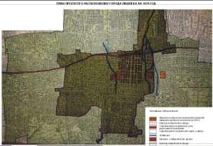
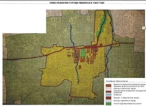
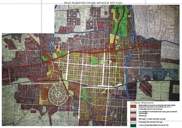
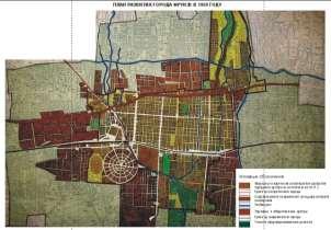
3 Comprehensive Assessment of the Current Status 1878 г г г г г. Historical background
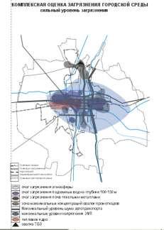
4 Comprehensive Assessment of the Current Status Natural Environment


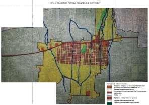
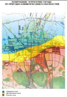
5 Comprehensive Assessment of the Current Status Urbanized Environment. Area of Impact by Bishkek
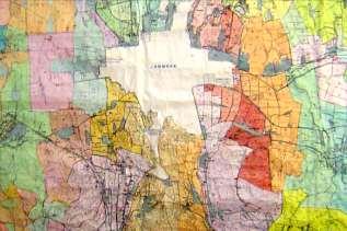

6 Comprehensive Assessment of the Current Status Urbanized Environment. Bishkek and its Suburbs
7 Forest of social and economic development of Bishkek city Thanks to own resources, sustainable progressive dynamics in economy development and the economic and geographical position in the Central Asian region, Bishkek city has unique socio-economic preconditions for progressive town-planning development, which guarantees dynamic growth in construction in a long-term run. Given the projected economic development of the Kyrgyz Republic and its capital, by 2025 Bishkek will become a large city in the Central Asian region. In addition to functions of a political, educational, administrative and cultural and industrial center of the KR, it will perform the functions of an international business and financial center (Regional Business Center). It will host a large regional transport terminal to handle air, railway and road shipments. According to projections for 2025 in terms of employment growth, increase in revenues and poverty liquidation, the structure of Bishkek city population by the level of the social status will correspond to that of cities in developed countries.
8

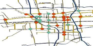
9 Interrelated development of Bishkek and the zone of its influence Implementation of socio-economic prerequisites implies in a long-term run to conduct global-scale activities on town-planning development of Bishkek and suburban village and other towns and settlements in the zone of its influence Scheme of territorial development of Bishkek city and its influence zone MANAS BISHKEK KARA-BALTA TOKMOK ТОКМОК International terminal Western Nucleus Central Nucleus Eastern Nucleus Sub-Centers of Chui Resettlement System
10 Socio-Economic Development of Bishkek until 2025 Estimated population of Bishkek city for a long-term run The de-facto population for thousand people and for ,200 thousand people; Daytime population for 2010 and as expected for 2025 is 1,100 and 1,500 thousand people accordingly, including the temporary 150 and 300 thousand people. Perspective social structure of the population: High income level thousand people (20%); Middle income level thousand people (60%); Income within the minimum living standard and below thousand people (20%). Availability of the housing fund and servicing institutions: Increase in the housing fund 2.3 times as a result of a shift from construction of few-story buildings to construction of multi-story, few-story dense and mixed story buildings; Increase in household everyday servicing facilities from 1.40 to 9.22 million m2, including the socially guaranteed level from 0.83 to 4.6 million m2 of total area; Increase in occasional servicing facilities 8.1 times from 0.57 to 4.62 million m2 of total area.


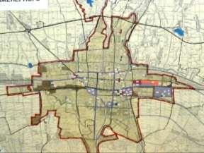
11 Concept of Territorial Development of Bishkek City Вариант 1А Вариант 1Б Options for territorial development of Bishkek and its zone of influence Концепция территориального развития на период за 2025 г. Вариант 1В

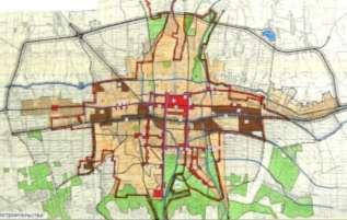
12 Key directions of town-planning development of Bishkek city Key directions of structural and functional structure of city territories. Scheme of functional zoning of territories Landscape and recreational zones Boundary of actual land use Projected boundary Residential zones Industrial zones Zone of external and suburban transport Territories of integrated suburban villages Territories of historical city Territories of agricultural land to be developed for the estimated time period Territories of Issyk-Ata tectonic fault

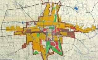
13 Key directions for formation of territories of the city system of public centers Scheme for formation of spatial backbone of Bishkek public center system Transport corridor Territories of public centers and multistory residential buildings Territories of suburban complex Territory of cultural and historical center Key city highways City trade and commercial centers Boundary of historical territories of the city Multifunctional commercial and business centers Territories of high-density residential buildings


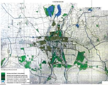
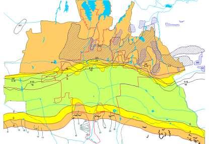
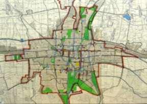
14 Scheme for organization of territories of the Natural Complex of Bishkek city Suburban forest-parks Water conservation zones of rivers, channels, lakes Existing green belt of general purpose Existing green belt of a special purpose Projected greed belts of general purpose Boundaries of existing especially protected natural territories Boundaries of projected especially protected natural territories
15 Scheme for organization of territories of the Natural Complex of Bishkek city Improvement of environments based on increase in urban plants of all categories up to 10,200 ha (85m2/person), including general purpose plantations 2,520 ha (21 m2/person); Irrigation of territories using temporary waters (from the depth of about 100 m) from wells within the city for spray irrigation in a closed network or irrigation using open irrigation network; Protection of city areas from river overflows; Water supply and conservation and rehabilitation of water courses (natural and artificial); Reducing the level of underground waters in northern areas of the city and prevention of nonpoint discharge of immediate runoff to water bodies; Mud-flow protection of city territories.
 and a waste processing plant MANAS KARA-BALTA")
16 Layout of location of landfills for industrial and solid household waste of Bishkek city and its zone of influence Options for location of landfills for industrial toxic and solid household waste and a waste processing plant Preferred option 10-km limitation zone for location of SHW landfills Options for location of high-load landfill for SHW (46 ha) and a waste processing plant MANAS KARA-BALTA BISHKEK

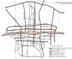
17 Scheme for organization of external transport of Bishkek city and its zone of influence MANAS KARA-BALTA BISHKEK TOKMOK Local roads International cargo terminal International transport corridor Traffic interchange at different levels Passenger suburban electric train stations Mainline of suburban electric train Administrative and business and public centers Inter-settlement regulated highways with regulated traffic

18 Almaty - Bishkek The distance between the two cities: along the road km, direct distance km. The estimated travel time between the cities by car is 3 hours 59 minutes.
The National Spatial Strategy
 Purpose of this Consultation Paper This paper seeks the views of a wide range of bodies, interests and members of the public on the issues which the National Spatial Strategy should address. These views
Opportunities and challenges of HCMC in the process of development
 Opportunities and challenges of HCMC in the process of development Lê Văn Thành HIDS HCMC, Sept. 16-17, 2009 Contents The city starting point Achievement and difficulties Development perspective and goals
HSC Geography. Year 2013 Mark Pages 10 Published Jul 4, Urban Dynamics. By James (97.9 ATAR)
") HSC Geography Year 2013 Mark 92.00 Pages 10 Published Jul 4, 2017 Urban Dynamics By James (97.9 ATAR) Powered by TCPDF (www.tcpdf.org) Your notes author, James. James achieved an ATAR of 97.9 in 2013 while
HSC Geography Year 2013 Mark 92.00 Pages 10 Published Jul 4, 2017 Urban Dynamics By James (97.9 ATAR) Powered by TCPDF (www.tcpdf.org) Your notes author, James. James achieved an ATAR of 97.9 in 2013 while
URBANIZATION PROCESSES IN THE KYRGYZ REPUBLIC. CASE STUDY: THE CITY OF BISHKEK
 STUDIA UBB GEOGRAPHIA, LXII, 1, 2017 (p. 77 85) (RECOMMENDED CITATION) DOI:10.24193/subbgeogr.2017.1.06 URBANIZATION PROCESSES IN THE KYRGYZ REPUBLIC. CASE STUDY: THE CITY OF BISHKEK M. DYLDAEV 1 ABSTRACT.
Land Use in the context of sustainable, smart and inclusive growth
 Land Use in the context of sustainable, smart and inclusive growth François Salgé Ministry of sustainable development France facilitator EUROGI vice president AFIGéO board member 1 Introduction e-content+
Too Close for Comfort
 Too Close for Comfort Overview South Carolina consists of urban, suburban, and rural communities. Students will utilize maps to label and describe the different land use classifications. Connection to
Typical information required from the data collection can be grouped into four categories, enumerated as below.
 Chapter 6 Data Collection 6.1 Overview The four-stage modeling, an important tool for forecasting future demand and performance of a transportation system, was developed for evaluating large-scale infrastructure
National Spatial Development Perspective (NSDP) Policy Coordination and Advisory Service
 Policy Coordination and Advisory Service") National Spatial Development Perspective (NSDP) Policy Coordination and Advisory Service 1 BACKGROUND The advances made in the First Decade by far supersede the weaknesses. Yet, if all indicators were
National Spatial Development Perspective (NSDP) Policy Coordination and Advisory Service 1 BACKGROUND The advances made in the First Decade by far supersede the weaknesses. Yet, if all indicators were
DETERMINE OF REGIONAL DEVELOPMENT STRATEGIES IN IZMIR
 Sukran Yalpir Asli Bozdag Saban Inam DETERMINE OF REGIONAL DEVELOPMENT STRATEGIES IN IZMIR Globalization INTRODUCTION Economic pressure cause Economic migration cause cause Spatial organizations Spatial
Measuring Disaster Risk for Urban areas in Asia-Pacific
 Measuring Disaster Risk for Urban areas in Asia-Pacific Acknowledgement: Trevor Clifford, Intl Consultant 1 SDG 11 Make cities and human settlements inclusive, safe, resilient and sustainable 11.1: By
Unit 9: Changing urban environments
 Name: Unit 9: Changing urban environments I can statement... RAG Score. R=1, A=2, G=3 9.1 What are the characteristics of urbanisation. I can describe what urbanisation is. I can describe what a push and
Your web browser (Safari 7) is out of date. For more security, comfort and the best experience on this site: Update your browser Ignore
 is out of date. For more security, comfort and the best experience on this site: Update your browser Ignore") Your web browser (Safari 7) is out of date. For more security, comfort and the best experience on this site: Update your browser Ignore urban area For the complete encyclopedic entry with media resources,
Your web browser (Safari 7) is out of date. For more security, comfort and the best experience on this site: Update your browser Ignore urban area For the complete encyclopedic entry with media resources,
Subject: Note on spatial issues in Urban South Africa From: Alain Bertaud Date: Oct 7, A. Spatial issues
 Page 1 of 6 Subject: Note on spatial issues in Urban South Africa From: Alain Bertaud Date: Oct 7, 2009 A. Spatial issues 1. Spatial issues and the South African economy Spatial concentration of economic
Belfairs Academy GEOGRAPHY Fundamentals Map
 YEAR 12 Fundamentals Unit 1 Contemporary Urban Places Urbanisation Urbanisation and its importance in human affairs. Global patterns of urbanisation since 1945. Urbanisation, suburbanisation, counter-urbanisation,
Data Collection. Lecture Notes in Transportation Systems Engineering. Prof. Tom V. Mathew. 1 Overview 1
 Data Collection Lecture Notes in Transportation Systems Engineering Prof. Tom V. Mathew Contents 1 Overview 1 2 Survey design 2 2.1 Information needed................................. 2 2.2 Study area.....................................
Understanding China Census Data with GIS By Shuming Bao and Susan Haynie China Data Center, University of Michigan
 Understanding China Census Data with GIS By Shuming Bao and Susan Haynie China Data Center, University of Michigan The Census data for China provides comprehensive demographic and business information
Identifying Megaregions in the US: Implications for Infrastructure Investment
 7. 10. 2 0 08 Identifying Megaregions in the US: Implications for Infrastructure Investment Dr. Myungje Woo Dr. Catherine L. Ross Jason Barringer Harry West Jessica Lynn Harbour Doyle Center for Quality
The 3V Approach. Transforming the Urban Space through Transit Oriented Development. Gerald Ollivier Transport Cluster Leader World Bank Hub Singapore
 Transforming the Urban Space through Transit Oriented Development The 3V Approach Gerald Ollivier Transport Cluster Leader World Bank Hub Singapore MDTF on Sustainable Urbanization The China-World Bank
Experience and perspectives of using EU funds and other funding for the implementation of district renovation projects
 Experience and perspectives of using EU funds and other funding for the implementation of district renovation projects Ministry of the Interior of Lithuania Regional policy department Administration, coordination,
Making space for a more foundational construction sector in Brussels
 Making space for a more foundational construction sector in Brussels Sarah De Boeck, David Bassens & Michael Ryckewaert Social innovation in the Foundational Economy Cardiff, 5 th of September 2018 1.
Topic 4: Changing cities
 Topic 4: Changing cities Overview of urban patterns and processes 4.1 Urbanisation is a global process a. Contrasting trends in urbanisation over the last 50 years in different parts of the world (developed,
May kindly Tim Page prepare the Bulgaria page header with the same design as the others? Bulgaria Urban Region of Sofia
 May kindly Tim Page prepare the Bulgaria page header with the same design as the others? Bulgaria Urban Region of Sofia National Planning Context Urban Region of Sofia Geography Statistics Trends Historical
Effects of a non-motorized transport infrastructure development in the Bucharest metropolitan area
 The Sustainable City IV: Urban Regeneration and Sustainability 589 Effects of a non-motorized transport infrastructure development in the Bucharest metropolitan area M. Popa, S. Raicu, D. Costescu & F.
MODULE 1 INTRODUCING THE TOWNSHIP RENEWAL CHALLENGE
 MODULE 1 INTRODUCING THE TOWNSHIP RENEWAL CHALLENGE FOCUS OF THE MODULE Township renewal challenges and developmental outcomes covered in this module: Historical origins of townships and the inherited
Global Atmospheric Circulation. Past climate change and natural causes. Global climate change and human activity
 GCSE Geography Edexcel B Revision Checklist Paper 1. Global Geographical Issues Topic 1. Hazardous Earth Key Idea I know/ understand The world s climate system Global Atmospheric Circulation Past climate
HAZUS-MH: Earthquake Event Report
 HAZUS-MH: Earthquake Event Report Region Name: El Paso County Earthquake Scenario: El Paso County Random EQ Print Date: February 08, 2006 Disclaimer: The estimates of social and economic impacts contained
Social Studies Grade 2 - Building a Society
 Social Studies Grade 2 - Building a Society Description The second grade curriculum provides students with a broad view of the political units around them, specifically their town, state, and country.
Spatial Planning in the Republic of Armenia
 Spatial Planning in the Republic of Armenia According to the Law of the Republic of Armenia on Urban Development, the main issues of the Republic s spatial development and actions for their solution are
The international patterns of spatial planning system and choice of China. Cai yumei China land use planning and surveying institute (China, beijing)
") FIG Working Week, Rome, Italy 6 10 May 2012 The international patterns of spatial system and choice of China Cai yumei China land use and surveying institute (China, beijing) Outline Background Problem
FIG Working Week, Rome, Italy 6 10 May 2012 The international patterns of spatial system and choice of China Cai yumei China land use and surveying institute (China, beijing) Outline Background Problem
Legal problems of environmental management. Spatial planning and space management. M. Gajewski 2014 / 2015
 Legal problems of environmental management Spatial planning and space management M. Gajewski 2014 / 2015 Course contents (in brief) Constitutional basis of the environment protection system. General principles
TABLE OF CONTENTS ARTICLE I. POLK COUNTY COMPREHENSIVE PLAN VOLUME 1. Page CHAPTER 1. GENERAL... A-1
 TABLE OF CONTENTS ARTICLE I. POLK COUNTY COMPREHENSIVE PLAN VOLUME 1 Page CHAPTER 1. GENERAL... A-1 DIVISION 1.100 GENERAL PROVISIONS... A-1 DIVISION 1.200 BASIC PRINCIPLES... A-6 DIVISION 1.300 THE PLANNING
Urban development. The compact city concept was seen as an approach that could end the evil of urban sprawl
 The compact city Outline 1. The Compact City i. Concept ii. Advantages and the paradox of the compact city iii. Key factor travel behavior 2. Urban sustainability i. Definition ii. Evaluating the compact
CLLD Cooperation OFFER
 Title of the proposed project (English) CLLD Cooperation OFFER PARKS PROTECTION III - Management, Protection and Economic Development in Protected Areas Type of project (select as many as you want) Cooperation
16540/14 EE/cm 1 DG E 1A
 Council of the European Union Brussels, 5 December 2014 (OR. en) 16540/14 ENV 965 CULT 139 NOTE From: To: Subject: General Secretariat of the Council Delegations Charter of Rome on Natural and Cultural
Proposal for International Workshop on Defining and Measuring Metropolitan Regions. II. Definition and Measurement of Metropolitan Area in Japan
 November 20, 2006 Proposal for International Workshop on Defining and Measuring Metropolitan Regions Japanese Government I. Introduction II. Definition and Measurement of Metropolitan Area in
Socio-Economic and Ecological Indicators of the Metropolitan Area of Bucharest
 12 Socio-Economic and Ecological Indicators of the Metropolitan Area of Bucharest Gabriela Ţigu 1, Olimpia State 2, Delia Popescu 3 1 Prof. PhD, The Bucharest Academy of Economic Studies 2,3 Assoc. Prof.
The Concepts of Post-industrial Shift and their Relevance to the Arctic Context: A City Study of Iqaluit, Nunavut.
 The Concepts of Post-industrial Shift and their Relevance to the Arctic Context: A City Study of Iqaluit, Nunavut. Hugo Haley Abstract Mega-trends emerge from the restructuring of the global economy. These
Making maps: Traditions and perceptions in Europe. European spatial planning and cartographic representations
 ESPON Create Europe! Making maps: Traditions and perceptions in Europe Dr. Stefanie Dühr University of the West of England, Bristol, UK European spatial planning and cartographic representations Scenarios.
CHAPTER 4 HIGH LEVEL SPATIAL DEVELOPMENT FRAMEWORK (SDF) Page 95
 Page 95") CHAPTER 4 HIGH LEVEL SPATIAL DEVELOPMENT FRAMEWORK (SDF) Page 95 CHAPTER 4 HIGH LEVEL SPATIAL DEVELOPMENT FRAMEWORK 4.1 INTRODUCTION This chapter provides a high level overview of George Municipality s
CHAPTER 4 HIGH LEVEL SPATIAL DEVELOPMENT FRAMEWORK (SDF) Page 95 CHAPTER 4 HIGH LEVEL SPATIAL DEVELOPMENT FRAMEWORK 4.1 INTRODUCTION This chapter provides a high level overview of George Municipality s
ANALYZING CITIES & POPULATION: POPULATION GEOGRAPHY
 ANALYZING CITIES & POPULATION: POPULATION GEOGRAPHY Population Geography Population Geography study of the number, contribution, and distribution of human populations Demography the study of the characteristics
Together towards a Sustainable Urban Agenda
 Together towards a Sustainable Urban Agenda The City We (Youth) Want Preliminary findings from youth consultations Areas Issue Papers Policy Units 1.Social Cohesion and Equity - Livable Cities 2.Urban
Local Area Key Issues Paper No. 13: Southern Hinterland townships growth opportunities
 Draft Sunshine Coast Planning Scheme Review of Submissions Local Area Key Issues Paper No. 13: Southern Hinterland townships growth opportunities Key Issue: Growth opportunities for Southern Hinterland
REGIONAL DEVELOPMENT AND SPATIAL PLANNING IN BULGARIA: GEOGRAPHICAL PERSPECTIVES
 1 REGIONAL DEVELOPMENT AND SPATIAL PLANNING IN BULGARIA: GEOGRAPHICAL PERSPECTIVES Assist. Prof. Kosyo Stoychev, PhD Sofia University St. Kliment Ohridski, Faculty of Geology and Geography k_stoychev@mail.bg
Coimisiún na Scrúduithe Stáit State Examinations Commission
 2008. M.24 Coimisiún na Scrúduithe Stáit State Examinations Commission LEAVING CERTIFICATE EXAMINATION, 2008 GEOGRAPHY HIGHER LEVEL FRIDAY, 6 JUNE AFTERNOON, 2.00 TO 4.50 Examination Number For the Examiner
Most people used to live like this
 Urbanization Most people used to live like this Increasingly people live like this. For the first time in history, there are now more urban residents than rural residents. Land Cover & Land Use Land cover
High speed network in Hauts-de-France Region. Värnamo, 17 th May 2018
 High speed network in Hauts-de-France Region Värnamo, 17 th May 2018 Hauts-de-France at the crossroads of the North-West Europe High speed train approach in France In the 1980s: will to link the main cities
PLANNING FOR SUSTAINABILITY IN SLOVENIAN TOWNS
 Int. Journal for Housing Science, Vol.31, No.3 pp 205-214, 2007 Published in the United States PLANNING FOR SUSTAINABILITY IN SLOVENIAN TOWNS Mojca Sasek Divjak Urban Planning Institute of the Republic
A Review of Concept of Peri-urban Area & Its Identification
 A Review of Concept of Peri-urban Area & Its Identification Ar. Manita Saxena Research Scholar Department of Architecture and Planning M.A.N.I.T, Bhopal Dr. Supriya Vyas Assistant Professor, Department
Operational Definitions of Urban, Rural and Urban Agglomeration for Monitoring Human Settlements
 Operational Definitions of Urban, Rural and Urban Agglomeration for Monitoring Human Settlements By Markandey Rai United Nations Human Settlements Programme PO Box-30030 Nairobi, Kenya Abstract The United
M14/3/GEOGR/SP2/ENG/TZ0/XX/Q GEOGRAPHY STANDARD LEVEL PAPER 2. Monday 19 May 2014 (morning) 1 hour 20 minutes INSTRUCTIONS TO CANDIDATES
 1 hour 20 minutes INSTRUCTIONS TO CANDIDATES") M14/3/GEOGR/SP2/ENG/TZ0/XX/Q 22145203 GEOGRAPHY STANDARD LEVEL PAPER 2 Monday 19 May 2014 (morning) 1 hour 20 minutes INSTRUCTIONS TO CANDIDATES Do not open this examination paper until instructed to do
M14/3/GEOGR/SP2/ENG/TZ0/XX/Q 22145203 GEOGRAPHY STANDARD LEVEL PAPER 2 Monday 19 May 2014 (morning) 1 hour 20 minutes INSTRUCTIONS TO CANDIDATES Do not open this examination paper until instructed to do
GCE. Geography. Mark Scheme for January Advanced Subsidiary GCE Unit F762: Managing Change in Human Environments
 GCE Geography Advanced Subsidiary GCE Unit F762: Managing Change in Human Environments Mark Scheme for January 2012 Oxford Cambridge and RSA Examinations OCR (Oxford Cambridge and RSA) is a leading UK
The Contested Cultural Landscape of a Lebanese Border Town: MARJA AYOUN
 The Contested Cultural Landscape of a Lebanese Border Town: MARJA AYOUN IBD 2013 FNAS MAY 2013 Dr. Christine Mady, City & Regional Planning NDU -FAAD In this Presentation A PLANNING PERSPECTIVE INTRODUCING
BIG IDEAS. Area of Learning: SOCIAL STUDIES Urban Studies Grade 12. Learning Standards. Curricular Competencies
 Area of Learning: SOCIAL STUDIES Urban Studies Grade 12 BIG IDEAS Urbanization is a critical force that shapes both human life and the planet. The historical development of cities has been shaped by geographic,
The importance of visioning in urban strategic planning By Peter Robinson. MILE Master Class Urban Strategic Planning March 2016
 The importance of visioning in urban strategic planning By Peter Robinson MILE Master Class Urban Strategic Planning March 2016 Typical strategic planning process Where are we now? Where are we going?
GIS Geographical Information Systems. GIS Management
 GIS Geographical Information Systems GIS Management Difficulties on establishing a GIS Funding GIS Determining Project Standards Data Gathering Map Development Recruiting GIS Professionals Educating Staff
This table connects the content provided by Education Perfect to the NSW Syllabus.
 Education Perfect Geography provides teachers with a wide range of quality, engaging and innovative content to drive positive student learning outcomes. Designed by teachers and written by our in-house
3 rd Grade Social Studies Pacing Guide Arkansas Frameworks
 3 rd Grade Social Studies Pacing Guide Arkansas Frameworks 1st Nine Weeks Strand1: Geography Standard 1: Physical and Spatial Students shall develop an understanding of the physical and spatial characteristics
APPENDIX PHASE 1 GREEN INFRASTRUCTURE FRAMEWORK
 APPENDIX PHASE 1 GREEN INFRASTRUCTURE FRAMEWORK KANSAS MISSOURI CONTENTS A DATA WISHLIST 4 B PRECEDENTS 7 C WORKSHOP MATERIALS 13 D ANALYSIS PROCESS 124 E ATLAS & PLAYBOOK DETAILS 156 F POLICY ANALYSIS
Rural Gentrification: Middle Class Migration from Urban to Rural Areas. Sevinç Bahar YENIGÜL
 'New Ideas and New Generations of Regional Policy in Eastern Europe' International Conference 7-8 th of April 2016, Pecs, Hungary Rural Gentrification: Middle Class Migration from Urban to Rural Areas
East Bay BRT. Planning for Bus Rapid Transit
 East Bay BRT Planning for Bus Rapid Transit Regional Vision Draper Prison The Bottleneck is a State-Level issue, Salt Lake County 2050 Population: 1.5M Draper Prison hopefully with some State-Level funding!
State initiative following up the 2006 national planning report
 18 ness districts and public institutions, should be integrated with the opportunities for public transport services. State initiative following up the 2006 national planning report The Ministry of the
The Governance of Land Use
 The planning system Levels of government and their responsibilities The Governance of Land Use COUNTRY FACT SHEET NORWAY Norway is a unitary state with three levels of government; the national level, 19
LOCATIONAL PREFERENCES OF FDI FIRMS IN TURKEY
 LOCATIONAL PREFERENCES OF FDI FIRMS IN TURKEY Prof. Dr. Lale BERKÖZ Assist. Prof. Dr.S. SenceTÜRK I.T.U. Faculty of Architecture Istanbul/TURKEY E-mail: lberkoz@itu.edu.tr INTRODUCTION Foreign direct investment
Urban Planning Word Search Level 1
 Urban Planning Word Search Level 1 B C P U E C O S Y S T E M P A R E U O E U R B A N P L A N N E R T N S T D H E C O U N T Y G E R E R D W R E N I C I T Y C O U N C I L A A A S U G G C I L A G P R I R
Set-up of subnational statistical systems Statistical Development Strategy for the State of Jalisco México, 2016
 Set-up of subnational statistical systems Statistical Development Strategy for the State of Jalisco México, 2016 Statistical and Geographical Information Institute of Jalisco (IIEG) 2013. Merger of three
Spatial analysis of locational conflicts
 Spatial analysis of locational conflicts Case study: Locational conflicts generated by the expansion of built up surfaces in the northern area of Bucharest, Romania Diana A. ONOSE 1, Cristian I. IOJĂ 2,
Socials Studies. Chapter 3 Canada s People 3.0-Human Geography
 Socials Studies Chapter 3 Canada s People 3.0-Human Geography Physical Geography Study of the natural features of the Earth s surface including landforms, climate, ocean currents and flora and fauna Human
Grade 9 Social Studies Canadian Identity. Chapter 3 Review Canada s People. Chapter 3: Canada s People
 Grade 9 Social Studies Canadian Identity Chapter 3 Review Canada s People Chapter 3: Canada s People Terms (notes or textbook) Population Distribution Site Factors Seigneurial system Corridors Urbanization
COSTA RICA Limon City-Port Project
 COSTA RICA Limon City-Port Project 2008 2013 photos by Stefania Abakerli Stefania Abakerli Cecilia Corvalan Context Costa Rica Well-known tourist destination in CA (8.4% GDP) Long tradition of political
Navigable maritime and river waterways in the seaside - Danube Delta area and the connected rural development
 SUMMARY OF Ph-D Thesis, with title RESEARCH STUDIES ON MANAGEMENT IMPROVEMENT OF MARITIME AND RIVER TRANSPORT ACTIVITY IN THE COASTAL AND DANUBE DELTA AREA FROM AN ENVIROMENTAL, ECONOMIC AND SOCIAL PERSPECTIVE
Building the Sustainable Network of Settlements on the Caspian Sea Region of Kazakhstan
 Building the Sustainable Network of Settlements on the Caspian Sea Region of Kazakhstan Introduction The Ecological Zoning and Identification of Ecological Capacity of Natural and Socio- Economic Potential
Tackling urban sprawl: towards a compact model of cities? David Ludlow University of the West of England (UWE) 19 June 2014
 19 June 2014") Tackling urban sprawl: towards a compact model of cities? David Ludlow University of the West of England (UWE) 19 June 2014 Impacts on Natural & Protected Areas why sprawl matters? Sprawl creates environmental,
Tackling urban sprawl: towards a compact model of cities? David Ludlow University of the West of England (UWE) 19 June 2014 Impacts on Natural & Protected Areas why sprawl matters? Sprawl creates environmental,
CORPORATION OF THE CITY OF COURTENAY COUNCIL MEETING AGENDA
 CORPORATION OF THE CITY OF COURTENAY COUNCIL MEETING AGENDA DATE: Monday, January 14, 2013 PLACE: City Hall Council Chambers TIME: 4:00 p.m. 1.00 ADOPTION OF MINUTES 1. Adopt January 7, 2013 Regular Council
Valuation of environmental amenities in urban land price: A case study in the Ulaanbaatar city, Mongolia
 1989 1990 1991 1992 1993 1994 1995 1996 1997 1998 1999 2000 2001 2002 2003 2004 2005 2006 2007 2008 2009 2010 2011 Population Valuation of environmental amenities in urban land price: A case study in the
Chapter 2: Description of Planning Area
 2020 Facilities Plan Facilities Plan Report Chapter 2: Description of Planning Area 2.1 Introduction This chapter describes Milwaukee Metropolitan Sewerage District s (MMSD) planning area and existing
Levels of spatial planning, Preparatory Land Use Plan, Sustainable Development. The Stuttgart Example
 Levels of spatial planning, Preparatory Land Use Plan, Sustainable Development. The Stuttgart Example Dipl.-Ing. Robert Schulze Dieckhoff Urban Planner Department of City Planning and Urban Renewal State
Leveraging Urban Mobility Strategies to Improve Accessibility and Productivity of Cities
 Leveraging Urban Mobility Strategies to Improve Accessibility and Productivity of Cities Aiga Stokenberga World Bank GPSC African Regional Workshop May 15, 2018 Roadmap 1. Africa s urbanization and its
Problems In Large Cities
 Chapter 11 Problems In Large Cities Create a list of at least 10 problems that exist in large cities. Consider problems that you have read about in this and other chapters and/or experienced yourself.
IOP Conference Series: Earth and Environmental Science. Related content OPEN ACCESS
 IOP Conference Series: Earth and Environmental Science OPEN ACCESS Using GIS to integrate the analysis of land-use, transportation, and the environment for managing urban growth based on transit oriented
Dar es Salaam - Reality Check Workshop
 Dar es Salaam - Reality Check Workshop hosted by GIZ and Dar es Salaam City Council Introduction: Key Urban Characteristics of Dar es Salaam Challenges and Opportunities for Resilient Development in the
Monmouth County Adam Nassr (Partner: Brian Berkowitz, Ocean County)
") Monmouth County Adam Nassr (Partner: Brian Berkowitz, Ocean County) 1. County Summary Monmouth County, founded in 1675, is the northernmost county along the Jersey Shore in the state of New Jersey. It
Monmouth County Adam Nassr (Partner: Brian Berkowitz, Ocean County) 1. County Summary Monmouth County, founded in 1675, is the northernmost county along the Jersey Shore in the state of New Jersey. It
[ ] MONITORING THE SPATIAL IMPACTS OF THE EGNATIA MOTORWAY egnatia odos observatory
![[ ] MONITORING THE SPATIAL IMPACTS OF THE EGNATIA MOTORWAY egnatia odos observatory](/thumbs/72/66290986.jpg "[ ] MONITORING THE SPATIAL IMPACTS OF THE EGNATIA MOTORWAY egnatia odos observatory") ] egnatia odos observatory MONITORING THE SPATIAL IMPACTS OF THE EGNATIA MOTORWAY 2014 http://observatory.egnatia.gr MINISTRY OF INFRASTRUCTURE, TRANSPORT AND NETWORKS 2 A tool at the service of spatial
] egnatia odos observatory MONITORING THE SPATIAL IMPACTS OF THE EGNATIA MOTORWAY 2014 http://observatory.egnatia.gr MINISTRY OF INFRASTRUCTURE, TRANSPORT AND NETWORKS 2 A tool at the service of spatial
DRAFT PROGRAM Registration of participants, welcome coffee, exhibition tour
 DRAFT PROGRAM 20 Feb 2018 09.00-10.00 Registration of participants, welcome coffee, exhibition tour 10.00 12.00 ROUND TABLE: INTERNATIONAL COOPERATION IN THE ARCTIC PROJECTS: CHALLENGES AND OPPORTUNITIES
Grade Level, Course Third Grade Social Studies PLSD Balanced Assessment Practices. Type* DOK
 Unit Guides Assessment Items Indic ator s Concept Standard Curricular Indicator DOK Type* SR CR PB Assessment Questions # DOK Level 1E 1M 1H 2E 2M 2H 3E 3M 3H Civics Students will develop and apply the
COSTA RICA Limon City-Port Project
 photos by Stefania Abakerli COSTA RICA Limon City-Port Project 2008 2013 Cecilia Corvalan William Reuben Stefania Abakerli Background Request from GoCR following Caldera-Port Concession Reform Since the
Long Term Plan What is planned for Murchison?
 Long Term Plan 2018-2028 What is planned for Murchison? 1.0 Introduction The following information provides an overview of significant projects Council has planned for the Murchison settlement in the Long
Figure 10. Travel time accessibility for heavy trucks
 Figure 10. Travel time accessibility for heavy trucks Heavy truck travel time from Rotterdam to each European cities respecting the prescribed speed in France on the different networks - Road, motorway
Progress and Land-Use Characteristics of Urban Sprawl in Busan Metropolitan City using Remote sensing and GIS
 Progress and Land-Use Characteristics of Urban Sprawl in Busan Metropolitan City using Remote sensing and GIS Homyung Park, Taekyung Baek, Yongeun Shin, Hungkwan Kim ABSTRACT Satellite image is very usefully
Assessment of Sustainable Land Use within the Town Planning Process Experiences with a Multi Criteria Approach (MCA)
") Assessment of Sustainable Land Use within the Town Planning Process Experiences with a Multi Criteria Approach (MCA) Dipl.-Geogr. Sophie Schetke Dipl.-Ing. Benedikt Frielinghaus, University of Bonn, Germany
Assessment of Sustainable Land Use within the Town Planning Process Experiences with a Multi Criteria Approach (MCA) Dipl.-Geogr. Sophie Schetke Dipl.-Ing. Benedikt Frielinghaus, University of Bonn, Germany
Preparation of Database for Urban Development
 Preparation of Database for Urban Development By PunyaP OLI, 1. Chairman, ERMC (P) Ltd., Kathmandu, Nepal. Email: punyaoli@ermcnepal.com 2. Coordinator, Himalayan College of Geomatic Engineering and Land
1 Business Development
 1 Business Development Existing developed economy in this Euroregion, based on the position both municipalities (Ruse and Giurgiu) have in the national and regional economies of both countries Diverse
Welcome to GCSE Geography. Where will it take us today?
 Welcome to GCSE Geography Where will it take us today? Urban Futures Dynamic Development Resource Reliance UK in the 21 st Century Global Hazards Changing Climate Distinctive Landscapes Sustaining Ecosystems
CLAREMONT MASTER PLAN 2017: LAND USE COMMUNITY INPUT
 Planning and Development Department 14 North Street Claremont, New Hampshire 03743 Ph: (603) 542-7008 Fax: (603) 542-7033 Email: cityplanner@claremontnh.com www.claremontnh.com CLAREMONT MASTER PLAN 2017:
INSTITUTIONAL BRIEF National Secretariat for Housing and Habitat
 INSTITUTIONAL BRIEF National Secretariat for Housing and Habitat Minister Soledad Nuñez @solenu www.senavitat.gov.py ASUNCION, PARAGUAY PARAGUAY LOCATION Landlocked with dry and wet borders PARAGUAY KEY
Enquiry question: How does the world s climate system function, why does it change and how can this be hazardous for people?
 Content Topic 1: Hazardous Earth Enquiry question: How does the world s climate system function, why does it change and how can this be hazardous for people? 1.1 The atmosphere operates as a global system
The Spatial Structure of Cities: International Examples of the Interaction of Government, Topography and Markets
 Module 2: Spatial Analysis and Urban Land Planning The Spatial Structure of Cities: International Examples of the Interaction of Government, Topography and Markets Alain Bertaud Urbanist Summary What are
Sample assessment task. Task details. Content description. Year level 7
 Sample assessment task Year level 7 Learning area Subject Title of task Task details Description of task Type of assessment Purpose of assessment Assessment strategy Evidence to be collected Suggested
UNIVERSITY OF NAIROBI COLLEGE OF HUMANITIES AND SOCIAL SCIENCES FACULTY OF ARTS & SCHOOL OF PHYSICAL SCIENCES
 UNIVERSITY OF NAIROBI COLLEGE OF HUMANITIES AND SOCIAL SCIENCES FACULTY OF ARTS & SCHOOL OF PHYSICAL SCIENCES Department of Geography and Environmental Studies TEACHING MODULE CGP/SGP 321: ECONOMIC GEOGRAPHY
Chapter 9: Urban Geography
 Chapter 9: Urban Geography The Five Steps to Chapter Success Step 1: Read the Chapter Summary below, preview the Key Questions, and Geographic Concepts. Step 2: Complete the Pre-Reading Activity (PRA)
Sustainable tourism in for Sustaibale Danang
 Sustainable tourism in for Sustaibale Danang A case study of Balearic Ecotax in Spain toward Sustainable tourism Miki Yoshizumi Associate Professor College of Gastronomy Management Ritsumeikan University