Socials Studies. Chapter 3 Canada s People 3.0-Human Geography
|
|
|
- Juliana Goodwin
- 5 years ago
- Views:
Transcription
1 Socials Studies Chapter 3 Canada s People 3.0-Human Geography
2 Physical Geography Study of the natural features of the Earth s surface including landforms, climate, ocean currents and flora and fauna
3 Human Geography Study of people and their communities, cultures, economies and interactions with the environment
4 Physical Environment Determines Human Settlement Patterns The physical environment of a region determines whether it is a good place to settle based on its natural resources such as soil, water supply and/or its climate. Fishing, logging, and farming are all examples of how the physical environment would influence human settlement to a particular area.
5 Physical Environment Determines Human Settlement Patterns Appalachian Mountain region: fishing, lumbering and shipbuilding Great Lakes-St. Lawrence Lowlands: good for farming, now site for many of Canada s major cities. Interior Plains: Wheat farming and ranching Western Cordillera: Logging, Farming and Fishing Arctic Lowlands: few people live there because of poor soil and climate
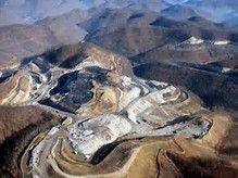
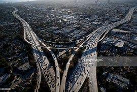
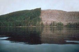
6 Human Activities Change The Physical Environment The introduction of the automobile Clear cutting forests Mountain mining Global warming

7 Human Activities Changing The Physical Environment
8 3.1 Rural and Urban Communities Create a t-chart on what you already know about Rural and Urban Communities. In your chart you should think of an example, and the characteristics of that example. Urban Rural

9 Rural Areas that are often agricultural and located outside towns and cities. What are some local and national examples?

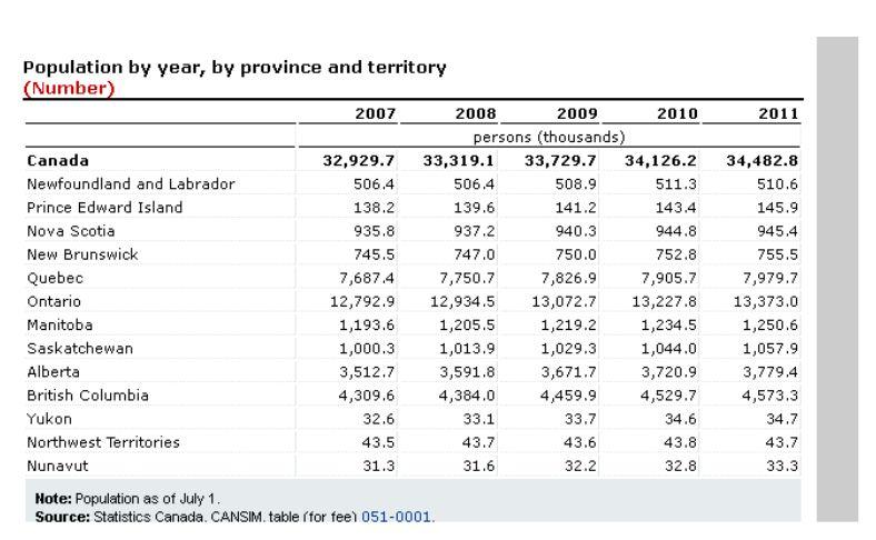
10 Urban Towns and cities with a population with 1000 or more. Or, with a population density of at least 400 people per square km. What are some local and national examples?

11 Population Distribution Population distribution is how we describe where people choose to live in a country.
12 World Population Distribution l/earth_lights.jpg
13 Archipelago Effect This is simply an analogy (comparison) of how the population of Canada is pockets of settlements, that looks like a group of islands (a group of islands is called an archipelago). See figure 3.1, page 42-43

14 Population Density A measure of how closely people live together in a given country OR area. Example: The houses in downtown St. John s are very close together. The houses on Marine Drive are farther apart. See figure 3.3 on page 44.
15 How to calculate Population Density Population of an area= A Size of an area in square kilometers=b A/B=population density= ppl/km2 Example: YOU CALCULATE!!! Population of Town is Size of area in square kilometers is 2000 square kilometers
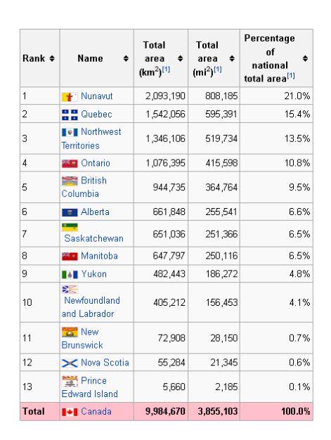
16 Name it-urban or Rural Population Area Population Density 33,300 2,093,190 km2 Urban or Rural? 7,979,700 1,542,056 km2 Urban or Rural? ,984,670 km² Urban or Rural?
17 Create the chart in your notebooks Provinces NL PEI NS NB QUE ONT ETC (fill in remainder of the provinces yourself) Area Population Population Density
18
19
20 Provinces Area (km2) Population Population Density NL ppl/km2 PEI ppl/km2 NS ppl/km2 NB ppl/km2 QUE ppl/km2 ONT ppl/km2 AB ppl/km2 MB ppl/km2 SK ppl/km2 BC ppl/km2
21 Questions Where is Canada most thinly populated? Which area is most densely populated? Name two other highly populated areas. How do these highly populated areas relate to the location of Canada s main urban centers? How accurate is it to say that Canada s population is mainly concentrated along the US/Canada border (islands of population-archipelago) Why can t you only examine population density when studying population distribution (see Canada vs Netherlands example on page 44)
22 Settlement Patterns The people who lived in Canada prior to European settlement were the Aboriginal or Indigenous groups. Europeans were attached to the areas that were inhabited by the aboriginal group because of the site (physical) and situation (site s relationship to other places) factors.
23 Aboriginal/Indigenous Populations Inuit-Live in Arctic Canada (Nunavut, NWT, Lab, Que). Inuktitut is the language of the Inuit. Metis-are of First Nations and European ancestry. Live primarily on the Prairies, and in Ontario and the NWT. First Nations-use this term when referring to more than one group of indigenous people.
24 3.2 Make a value Judgement! Overtime there has been a decline in traditional activities of Aboriginal peoples. In your opinion, who should take responsibility for these changes?

25 3.2 Account for the growth and decline of settlements Site Factors: Features of the physical landscape that attract people. What are some physical features that attracted people to Halifax? Military outpost (easy to protect) Ice-free port Protected harbour Railway hub (late 1800s)
 Railway hub in the 1800 s Shipping centre for goods (coming in from Europe and going out from Canada) Regional Centre of Gov t and services all these required workers, who moved to the")
26 3.2 Account for the growth and decline of settlements Situational Factors A sites relationship to other places. Things about the area attract people to the spot. (Like Halifax) Railway hub in the 1800 s Shipping centre for goods (coming in from Europe and going out from Canada) Regional Centre of Gov t and services all these required workers, who moved to the area for jobs lots of workers encouraged manufacturing jobs in area (this declined as manufacturing could be done elsewhere for cheaper)
27 3.2 Classification of Communities A look at communities that reflect growth or decline over the years, such as through services: Villages/small towns Small stores Limited products or competition (ie. Only 1 gas station in town) Small doctor s office Small schools, or go to larger towns for high school Must travel for larger stores, shopping, etc. Cities Hospitals, universities, large banks, government offices Specialized services for large populations (ie. ENT doctors, etc.) Specialty stores Some services may spread outside a city, expanding to reach other local areas and increase their size.
28 Growth and Decline Settlements GROW because: Settlements DECLINE because: Changes in service Rural to Urban drift building of hospitals / schools / fire move from rural towns to larger dept. / government services centers move from agriculture to urban (technology / resource depletion / etc) Transportation Economic downturn new bridge / road / highway in area loss of jobs locally Climate better weather patterns local weather (ie. Less snow) Economics new industries / manufacturing / construction resulting in more jobs Lack of services lack of services / quality of services change in needs (older people need more health care vs education)
29 3.3 Canada: A Regional Perspective Regional analysis is a tool used by geographers to help bring order to their study. It involves breaking the whole into smaller parts to aid investigation and understanding. Identifying regions is a useful way to discuss the role played by natural and human resources on prosperity across Canada. In Canada regional identities are influenced by geographic factors. Canada has 5 geographic regions. Can you name them?
30 Characteristics of Regions can be divided in 4 Categories 1. Location 2. Physical and Cultural Characteristics 3. Political Perspective 4 Hierarchy
31 1. Location Communities within a region share a geographic location, often expressed in the regional name selected, such as Atlantic Canada or the Prairies.

32 2. Physical and Cultural Characteristics Regions have clearly defined physical and cultural characteristics. For example, the physical geography of the Prairies defines this location as regionally different from the Canadian Shield.


33 3.Political Perspective Geographic and political boundaries are not the same. For example, southern Ontario has the same kind of physical geography and economy as the Midwest region in the U.S. Together, they form one large region in North America. Similarly, Atlantic Canada and New England share common physical geography and culture. However, there are important political differences between the areas on either side of Canada U.S. border.
34 Introduction of Canada s Regions There are different ways to categorize regions in Canada. In this section you will learn about Canada s 5 regional political divisions (figure 3.11, page 53). Can you name the 5 regions on this map?


35 4. Hierarchy Regions contain smaller regions within them. This is called hierarchy. Just as Canada can be divided into regions to gain an understanding of the country, regions can be divided into smaller regions for study purposes. For example, if you were to analyze your province, you could first divide it into smaller regions. Department of tourism do this to promote tourism in different areas of a province. These 2 pictures are of N.S.
36 Canada s Political Regions (page 54) In your exercise, complete the t-chart on the political regions of Canada Region Location Physical/Cul Political Hierarchy tural Perspective Attributes
37 The Core and the Periphery Interaction among the 5 regions is a key factor in investigating the growth and prosperity of Canada. A tool that geographers use to understand this relationship is the concept of core and periphery and the relationships that develop between them.

38 Core The core is the nucleus of a geographic region, containing its most developed area, greatest wealth, and highest population density. Toronto is an example of a core. Over half of Canada s population lives in Southern Ontario and southern Quebec.

39 Periphery The periphery is all the areas outside the core. It is sometimes referred to as the hinterland. It supplies raw material, and provides a market for its manufactured products and services.

40 Windsor-Quebec City Corridor Over time, this corridor became the centre of Canada s financial services and the hub of transportation systems. This areas sends more Members of Parliament to Ottawa. Why? What affect does this have?
41 Core Cities in Canada Using the table on page 56, group and map the cities by region. What patterns begin to emerge? City Toronto Montreal Population, 2010 Main Function
42 Questions What factors have contributed to the development of the Windsor-Quebec City corridor as Canada s core? Is there a core within a core? What are some of the challenges to growth and prosperity for cities of the periphery? Where do you see yourself living in 20 years? Why?


43 3.4 Regional Identities Many regional identities are associated with local industries. What industries and identities are depicted below?

44 Three Jolly Fishermen 0/14/nl-fishermen-postcard-114.html (see video)
Grade 9 Social Studies Canadian Identity. Chapter 3 Review Canada s People. Chapter 3: Canada s People
 Grade 9 Social Studies Canadian Identity Chapter 3 Review Canada s People Chapter 3: Canada s People Terms (notes or textbook) Population Distribution Site Factors Seigneurial system Corridors Urbanization
Chapter 3. Canada s People. Please note, page # s may be wrong. I m using the older edition text for my notes
 Chapter 3 Canada s People Please note, page # s may be wrong. I m using the older edition text for my notes Introduction You need to remember all the physical features we studied in the last chapter. This
Explain the impact of location, climate, natural resources, and population distribution on Europe. a. Compare how the location, climate, and natural
 SS6G10 Explain the impact of location, climate, natural resources, and population distribution on Europe. a. Compare how the location, climate, and natural resources of Germany, the United Kingdom and
Reference: climate data for Prince George and other locations at the back of this handout
 Name/Date: Socials 9 Unit 2: Cultures, Conflict, and Colonization in British North America 2A Physical Geography of Canada References: Cranny, M. (1998) Crossroads: A Meeting of Nations, Ch. 6 Canadian
Physical Geography of the United States and Canada Chapter 5 A Land of Contrasts
 Physical Geography of the United States and Canada Chapter 5 A Land of Contrasts Land Area Together the U.S. and Canada cover more than 7 million square miles. In total area, Canada ranks 2 nd and the
Markville. CGC 1DL/PL Geography. Geography of Canada. Natural Environment Unit Test
 Markville CGC 1DL/PL Geography Geography of Canada Natural Environment Unit Test Name: Thinking /10 Knowledge /10 Application /10 Communication /10 Part A: Blanks (1 mark each) Thinking Choose the correct
The Region in Canadian Geography
 The Region in Canadian Geography Reading Course website (www.yorku.ca/anderson) Lists today s reading Laliberté et al (2015) Teaching the geographies of Canada: Reflections on pedagogy, curriculum, and
Landforms. Lesson 1: Physical Geography of Canada Mexico. Canada s mountainous eastern and western edges create a central region of fertile plains.
 Lesson 1: Physical Geography of Canada Mexico Landforms Canada s mountainous eastern and western edges create a central region of fertile plains. Collisions of tectonic plates thrust up a series of sharp-peaked
Grade 9 Social Studies Canadian Identity. Chapter 2 Review Canada s Physical Landscape
 Grade 9 Social Studies Canadian Identity Chapter 2 Review Canada s Physical Landscape Name: Unit 1: Empowerment Terms (notes or textbook) 1. Core 2. Crust 3. Mantle 4. Magma 5. Continental drift 6. Plate
Social Studies: Grade 4. Table of Contents
 Social Studies: Grade 4 Table of Contents Heritage and Citizenship Medieval Times Overview --------------------------- Page 1 Overall Expectations --------------------------- Page 1 Specific Expectations
Most people used to live like this
 Urbanization Most people used to live like this Increasingly people live like this. For the first time in history, there are now more urban residents than rural residents. Land Cover & Land Use Land cover
Hello everybody! 1) Please read through each question carefully.
 Please read through each question carefully.") Hello everybody! Using the textbook that has been shared with you in Google please keep track of what you are learning here in this document. This is preparation for your tasks in The Amazing Race Canada,
Hello everybody! Using the textbook that has been shared with you in Google please keep track of what you are learning here in this document. This is preparation for your tasks in The Amazing Race Canada,
Post Test Trimester 1 US & Canada 6th Grade-Study Guide
 Post Test Trimester 1 US & Canada 6th Grade-Study Guide Matching Fill in the blank by writing the letter of the correct term below. a. dominion f. indigenous b. Industrial Revolution g. interdependent
4th Grade Social Studies First Nine Weeks
 4th Grade Social Studies First Nine Weeks Multiple Choice Identify the choice that best completes the statement or answers the question. 1 Name the mountains that are located in the eastern United States.
Chapter 32. Australia & New Zealand
 Chapter 32 Australia & New Zealand Lesson 1: Physical Geography of Australia & New Zealand Landforms Australia lies between the Pacific and Indian Oceans in the Southern Hemisphere. Although an island,
About places and/or important events Landmarks Maps How the land is, hills or flat or mountain range Connected to maps World Different countries
 What do you think you know about geography? About places and/or important events Landmarks Maps How the land is, hills or flat or mountain range Connected to maps World Different countries What do you
AP Human Geography Free-response Questions
 AP Human Geography Free-response Questions 2000-2010 2000-preliminary test 1. A student concludes from maps of world languages and religions that Western Europe has greater cultural diversity than the
Grade Five Social Studies Assessment Regions/Native Americans
 Name Grade Five Social Studies Assessment Regions/Native Americans Use the map below to answer questions 1 and 2 1. (Geo 1) For this location give the name of the city found there. 38 N, 100 W a. Scottsbluff
Chapter 6, Part Colonizers arriving in North America found extremely landscapes. It looked different to region showing great.
 Social Studies 9 Unit 1 Worksheet Chapter 6, Part 1. 1. Colonizers arriving in North America found extremely landscapes. It looked different to region showing great. 2. The Earth is years old and is composed
Factors Affecting Human Settlement
 Factors Affecting Human Settlement Physical Factors One of the most basic factors affecting settlement patterns is the physical geography of the land. Climate is key, because if a place is too dry, too
The study of Geography and the use of geographic tools help us view the world in new ways.
 S How does Geography help us understand our world? What factors shape the Earth s different environments? 7.1.9 7.2.9 BIG IDEAS COMPETENCIES Text pages or The study of Geography and the use of geographic
MARS AREA SCHOOL DISTRICT CURRICULUM GRADE: Grade 4
 MARS AREA SCHOOL DISTRICT CURRICULUM GRADE: Grade 4 Course Title: Social Studies Brief Description Overview: Students will explore the history, geography, government, and economy of the United States with
Chapter 32. Australia & New Zealand
 Chapter 32 Australia & New Zealand Lesson 1: Physical Geography of Australia & New Zealand Landforms Australia lies between the Pacific and Indian Oceans in the Southern Hemisphere. Although an island,
Urban Foundations. Early American Cities. Early American Cities. Early American Cities. Cities in America to 1945
 Urban Foundations Cities in America to 1945 Early American Cities The design of early American cities was highly influenced by European traditions The roots of many of these traditions can in turn be traced
Middle School. Assessment Focus: Strand 2 Developing a Geographic Perspective. Geography Content Standard Location, Movement, and Connection
 MS05 Michigan Geographic Alliance(1996) Geography Sample Item Middle School Assessment Focus: Strand 2 Developing a Geographic Perspective Geography Content Standard Location, Movement, and Connection
Climate Change: How it impacts Canadians and what we can do to slow it down.
 Climate Change: How it impacts Canadians and what we can do to slow it down. Lesson Overview This lesson takes stock of how climate change has already affected Canadians in geographic, economic, and cultural
The National Spatial Strategy
 Purpose of this Consultation Paper This paper seeks the views of a wide range of bodies, interests and members of the public on the issues which the National Spatial Strategy should address. These views
Too Close for Comfort
 Too Close for Comfort Overview South Carolina consists of urban, suburban, and rural communities. Students will utilize maps to label and describe the different land use classifications. Connection to
Minnesota K-12 Academic Standards in Social Studies. Grade 4: Geography of North America
 Minnesota K-12 Academic s in Social Studies Grade 4: Geography of North America 4 Describe how people take 1. Democratic government action to influence a depends on informed and decision on a specific
Population Density. Population density: A measure of how crowded a place is.
 Population Density Population density: A measure of how crowded a place is. Formula: Population Density = Population Total Area km 2 Overall Canada has a low population density of about 3 people per km
4 th Grade Virginia Studies SOL Review Packet Geography of Virginia. 1. The Algonquian language group of Indians lived in what region of Virginia?
 4 th Grade Virginia Studies SOL Review Packet Geography of Virginia 1. The Algonquian language group of Indians lived in what region of Virginia? A. Allegheny B. Piedmont C. Ridge and Valley D. Tidewater
CHAPTER 1: EXPLORING GEOGRAPHY
 CHAPTER 1: EXPLORING GEOGRAPHY Please Do Now: In your PDN section of your binder answer the following with one or two sentences: What is Geography? What is Geography? The study of where people, places,
The Periphery in the Knowledge Economy
 REGIONS IN THE KNOWLEDGE ECONOMY REGIONS ET ECONOMIE DU SAVOIR Mario Polese Richard Shearmur, in collaboration with Pierre-Marcel Desjardins Marc Johnson The Periphery in the Knowledge Economy The Spatial
Historical Fisheries off the Grand Banks (Wet and Dry Fisheries)
") Lesson Overview Historical Fisheries off the Grand Banks (Wet and Dry Fisheries) The French conducted the earliest trans-atlantic fishery with the Portuguese fishermen, soon joined by Basques, who took
Lesson Overview Historical Fisheries off the Grand Banks (Wet and Dry Fisheries) The French conducted the earliest trans-atlantic fishery with the Portuguese fishermen, soon joined by Basques, who took
Subunit 4.1: 2.5 hours. Subunit 4.2: 2.75 hours. Subunit 4.3: 1.5 hours. Subunit 4.4: 3.5 hours. Subunit 4.5: 1.5 hours Unit 4 Learning Outcomes close
 Unit 4: North America The realm of North America extends from the polar regions of the Arctic in northern Canada and Alaska, all the way south through Mexico and the countries of Central America. Geographers
4th Grade U.S. Regional Geography
 4th Grade U.S. Regional Geography Multiple Choice Identify the choice that best completes the statement or answers the question. What does the term mainland mean in the sentence above? A the continent
Through their research, geographers gather a great deal of data about Canada.
 Ecozones What is an Ecozone? Through their research, geographers gather a great deal of data about Canada. To make sense of this information, they often organize and group areas with similar features.
CLLD Cooperation OFFER
 Title of the proposed project (English) CLLD Cooperation OFFER PARKS PROTECTION III - Management, Protection and Economic Development in Protected Areas Type of project (select as many as you want) Cooperation
Introduction to Human Geography. Unit 1: It s Nature and Perspective
 Introduction to Human Geography Unit 1: It s Nature and Perspective Questions that Geography addresses: Where are things located? Why are they important? How are places related? How are places connected?
Tuition, Medical and Behaviour Support Service
 Tuition, Medical and Behaviour Support Service Curriculum Policy - Primary Geography Reviewed: October 2018 Next Review: October 2019 Responsibility: Andrea Snow AIMS AND PRINCIPLES The national curriculum
22 cities with at least 10 million people See map for cities with red dots
 22 cities with at least 10 million people See map for cities with red dots Seven of these are in LDC s, more in future Fastest growing, high natural increase rates, loss of farming jobs and resulting migration
ANALYZING CITIES & POPULATION: POPULATION GEOGRAPHY
 ANALYZING CITIES & POPULATION: POPULATION GEOGRAPHY Population Geography Population Geography study of the number, contribution, and distribution of human populations Demography the study of the characteristics
Canadian Mapping Big Book
 Canadian Mapping Big Book Grades 4-6 Written by Lynda Golletz Illustrated by S&S Learning Materials About the Author: Lynda Golletz was an elementary school teacher for thirty-three years. She is the author
The Five Themes of Geography Identification Slide Show. Developed by Joseph Naumann
 The Five Themes of Geography Identification Slide Show Developed by Joseph Naumann 1 5 Themes & Geographic Questions PLACE LOCATION HUMAN ENVIRONMENT/ INTERACTION REGION MOVEMENT 2 Location determining
Anoka Hennepin K 12 Curriculum Unit Plan
 Anoka Hennepin K 12 Curriculum Unit Plan Department: Social Studies Grade Level: 4 Unit Title: Geographic Investigations Trimester: 2 and 3 (16) 55 minute lessons (can be (32) 25 minute lessons) Unit Summary:
ELEMENTS OF BASIC WORLD GEOGRAPHY TABLE OF CONTENTS UNIT 1 THE BASICS OF GEOGRAPHY AND NORTH AMERICA
 TABLE OF CONTENTS UNIT 1 THE BASICS OF GEOGRAPHY AND NORTH AMERICA IMPORTANT WORDS TO KNOW... 1 CHAPTER 1 THE BASICS OF GEOGRAPHY GEOGRAPHY... 2 TOOLS OF GEOGRAPHY... 3 EARTH...4 SEASONS, CLIMATE, AND
Amazing Canada Project! By Matthew Shim
 Amazing Canada Project! By Matthew Shim All Regions in Canada The Cordillera The Interior Plains The Canadian Shield The St. Lawrence Lowlands The Appalachians The Arctic Location Cordillera Location North
5th social studies geography (5thsocstud_geography)
") Name: Date: 1. Many of the Native Americans who lived on the Great Plains were nomadic people. Why did they move from place to place? A. They were finding new areas to mine. B. They were looking for fertile
Name: Date: 1. Many of the Native Americans who lived on the Great Plains were nomadic people. Why did they move from place to place? A. They were finding new areas to mine. B. They were looking for fertile
Unit 1: Geography. For additional information, refer to this website: 1 G e o g r a p h y
 Unit 1: Geography For additional information, refer to this website: http://mryoungtms.weebly.com/ 1 G e o g r a p h y Continents and Oceans SOL USI. 2a Essential Understanding: Continents are large land
Simple Solutions Social Studies Level 2. Level 2. Social Studies. Help Pages
 Level 2 Social Studies 147 148 adobe houses with bricks made of clay and straw ancestor a family member who lived before us appoint choose; leaders can appoint others barter trading one thing for another
2. What is a settlement? Why do services cluster in settlements?
 Chapter 12: Services Introduction and Case Study (p. 397-399) 1. What is a service? How do LDCs and MDCs differ in regards to the number of workers employed in service- sector jobs? 2. What is a settlement?
Cultural Diffusion. AP HG SRMHS Mr. Hensley
 Cultural Diffusion AP HG SRMHS Mr. Hensley Space-time compression: The reduction in time it takes for something to reach another place Because of technology, connections have reduced distance (not literally
6. What is the absolute location (latitude and longitude) and relative location of your home town or the town in which you attend school?
 and relative location of your home town or the town in which you attend school?") Social Studies 10 Chapter 1 Worksheet Directions: Be sure to complete reading the chapter before you attempt these questions. Be aware that the Chapter Test will cover everything you read in the chapter,
Social Studies 10 Chapter 1 Worksheet Directions: Be sure to complete reading the chapter before you attempt these questions. Be aware that the Chapter Test will cover everything you read in the chapter,
Geography Policy 2014
 Geography Policy 2014 DEFINITION Geography education should inspire in pupils a curiosity and fascination about the world and its people that will remain with them for the rest of their lives. Teaching
Utah Core Standards Science Grade: 3 - Adopted: 2002
 Main Criteria: Utah Core Standards Secondary Criteria: Subjects: Science, Social Studies Grade: 3 Correlation Options: Show Correlated / AREA OF UT.1. Utah Core Standards Science Grade: 3 - Adopted: 2002
TYPES OF GOVERNMENTS
 While the terms country, state, and nation are often used interchangeably, there is a difference. A State (note the capital "S") is a self-governing political entity. The term State can be used interchangeably
Canadian Explorers. Learning object La Vérendyre map
 Canadian Explorers Learning object La Vérendyre map Lesson overview Students will be inspired by La Vérendyre to become explorers themselves. Students will embark on a research expedition to discover the
Essential Questions What are the major physical components of the world, and how are they represented on a map? 3.4
 Third Grade Social Studies Unit One Six Weeks GEOGRAPHY Originally compiled by Russellville In order for students to understand that geography influences the development of a region as well as the interactions
Welcome to GCSE Geography. Where will it take us today?
 Welcome to GCSE Geography Where will it take us today? Urban Futures Dynamic Development Resource Reliance UK in the 21 st Century Global Hazards Changing Climate Distinctive Landscapes Sustaining Ecosystems
GEOGRAPHY - HIGHER LEVEL
 M.24 AN ROINN OIDEACHAIS AGUS EOLAÍOCHTA LEAVING CERTIFICATE EXAMINATION 2000 GEOGRAPHY - HIGHER LEVEL MONDAY, 12 JUNE AFTERNOON 2.00 TO 5.20 Four questions to be answered, namely Question 1, Question
Chapter 10 Human Settlement Geography Book 1 Class 12
 CHAPTER 10 HUMAN SETTLEMENTS 1. RURAL, SUB URBAN AND URBAN SETTLEMENTS: This classification is common worldwide but the criteria differ from country to country. 5. Criteria for classification differs from
MEADOWS PRIMARY SCHOOL and NURSERY GEOGRAPHY POLICY
 MEADOWS PRIMARY SCHOOL and NURSERY GEOGRAPHY POLICY Purpose of study The teaching of Geography at Meadows is done by following the 2014 National Curriculum. The planning and teaching of the subject aims
Key Issue 1: Where Are Services Distributed? INTRODUCING SERVICES AND SETTLEMENTS LEARNING OUTCOME DESCRIBE THE THREE TYPES OF SERVICES
 Revised 2017 NAME: PERIOD: Rubenstein: The Cultural Landscape (12 th edition) Chapter Twelve Services and Settlements (pages 430 thru 457) This is the primary means by which you will be taking notes this
Borchert s Epochs of American Urbanization
 Borchert s Epochs of American Urbanization Geographers define cities as intersecting points of communication and transportation. Cities serve multiple social, political, economic and cultural purposes.
CANADA S LANDFORM REGIONS
 CANADA S LANDFORM REGIONS Canada s Regions Canada is divided into Eight major regions. A Region is an area that is defined on the basis of the presence or absence of certain characteristics: Age of rock
Looking at Communities: Comparing Urban and Rural Neighborhoods
 Looking at Communities: Comparing Urban and Rural Neighborhoods OVERVIEW & OBJECTIVES Our urban areas have become so dominant that frequently the children we teach have no connection with and very few
GC1DR Exam Review 2013
 GC1DR Exam Review 2013 Name: Your exam is just around the corner! By completing this review, you will be EXTREMELY well prepared to write this exam. Part A ON A SEPARATE PIECE OF PAPER, please complete
Dublin City Schools Social Studies Graded Course of Study Grade 5 K-12 Social Studies Vision
 K-12 Social Studies Vision The Dublin City Schools K-12 Social Studies Education will provide many learning opportunities that will help students to: develop thinking as educated citizens who seek to understand
Services includes: Intro to Services Central Place Theory Urban Hierarchies
 Services includes: Intro to Services Central Place Theory Urban Hierarchies Introduction Services any activity that fulfills human wants/needs Services are located in settlements therefore our study of
Economic Geography of the Long Island Region
 Geography of Data Economic Geography of the Long Island Region Copyright 2011 AFG 1 The geography of economic activity requires: - the gathering of spatial data - the location of data geographically -
Monday September 11, 2017
 Monday September 11, 2017 Need: 9/11 Interview Paper Agenda: Good things Warm Up: Video and Reflection Circles Sharing Interview Stories Discussion Questions Whole group sharing Summarizer: Living in a
St John s Catholic Primary School. Geography Policy. Mission Statement
 St John s Catholic Primary School Geography Policy Mission Statement We at St John s strive for excellence in education by providing a safe, secure and caring family environment where individuals are valued
a. Hunting and gathering SE/TE: 17, 19, 21, 22, 23, 25, 30 b. Tool making SE/TE: 17, 18, 19, 22, 23 c. Use of fire SE/TE: 17, 23, 30
 Ohio Academic Content Standards, Social Studies, Benchmarks and Indicators (Grade 6) Grade Six History Students use materials drawn from the diversity of human experience to analyze and interpret significant
K- 5 Academic Standards in. Social Studies. June 2013
 K- 5 Academic s in Social Studies June 2013 Word Tables of s ONLY This Word version of the 2.17.12 social studies standards (DRAFT for Rulemaking 2.17.12) document contains the standards ONLY; no explanatory
Coimisiún na Scrúduithe Stáit State Examinations Commission
 M. 24 Coimisiún na Scrúduithe Stáit State Examinations Commission LEAVING CERTIFICATE EXAMINATION 2005 GEOGRAPHY HIGHER LEVEL MONDAY, 13 JUNE, AFTERNOON 1.30 TO 4.50 Four questions to be answered, namely
Grade 7 History Mr. Norton
 Grade 7 History Mr. Norton Section 1: Thinking Geographically Section 2: Land and Climates of the United States Section 3: The Tools of History Section 4: Economics and Other Social Sciences Grade 7 History
Social Studies 9 UNIT 2 GEOGRAPHIC INFLUENCES ON IDENTITY: PLACE AND PEOPLE
 Social Studies 9 UNIT 2 GEOGRAPHIC INFLUENCES ON IDENTITY: PLACE AND PEOPLE The Structure of the Earth To understand the forces that create Canada's physical landscape we must understand the structure
Answers to British Columbia Quizzes
 Answers to British Columbia Quizzes p. 1 Test Your Knowledge What do you remember from your review of the British Columbia section of the E-atlas? 1. What percentage of Canada's total area does British
Why Geography Matters
 Why Geography Matters Vocabulary words geography relative location absolute location physical feature human feature region modify adapt cause effect geography: The study of the Earth s physical and human
Name three countries in Europe.
 Name three countries in Europe. I will be able to identify the 5 themes of geography for Europe and locate the countries and capitals of Europe and the major physical features. People: Past: Through the
Regional Geography C. LANGDON WHITE. Professor Emeritus Stanford University EDWIN J. FOSCUE TOM L. MCKNIGHT
 Regional Geography of Anglo-America Sixth Edition C. LANGDON WHITE Professor Emeritus Stanford University EDWIN J. FOSCUE Late of Southern Methodist University TOM L. MCKNIGHT Professor of Geography University
Revised February 9, 2017
 Revised February 9, 2017 Geography of the U.S. II-A-1* Apply geographic tools of title, grid system, legends, symbols, scale and compass rose to construct and interpret maps. II-A-2* Translate geographic
Generic Success Criteria
 Generic Success Criteria Significance I can identify a short term and long term impact that a development/event/issue has/had locally/globally. I can discuss (verbally, graphically, etc.) how a development/event/issue
Answers to Northwest Territories Quizzes
 Answers to Northwest Territories Quizzes p. 1 Test Your Knowledge What do you remember from your review of the Northwest Territories section of the E-Atlas? 1. The first people to inhabit the Northwest
Guided Reading Activity
 Guided Reading Activity Lesson 1 Physical Features Essential Question: How does geography influence the way people live? A Vast Land Directions: Read the lesson and use your text to decide whether each
Urban Geography. Unit 7 - Settlement and Urbanization
 Urban Geography Unit 7 - Settlement and Urbanization Unit 7 is a logical extension of the population theme. In their analysis of the distribution of people on the earth s surface, students became aware
Why Do We Live Here? : A Historical Geographical Study of La Tabatiere, Quebec North Shore
 Why Do We Live Here? : A Historical Geographical Study of La Tabatiere, Quebec North Shore Lesson Overview Many communities and their occupants have historical connections to exploration routes and traditional
Content Area: Social Studies Standard: 1. History Prepared Graduates: Develop an understanding of how people view, construct, and interpret history
 Standard: 1. History Develop an understanding of how people view, construct, and interpret history 1. Organize and sequence events to understand the concepts of chronology and cause and effect in the history
Site and Situation. Site
 Site and Situation The study of settlement patterns is one of the most important aspects of urban geography. Settlements can range in size from a small village with a few hundred residents to a metropolitan
GEOGRAPHY OF THE UNITED STATES & CANADA. By Brett Lucas
 GEOGRAPHY OF THE UNITED STATES & CANADA By Brett Lucas THE APPALACHIANS & THE OZARKS Setting the Boundaries What states and provinces are part of the region? Eastern TN, western NC, eastern KY, western
Massachusetts Curriculum Frameworks Science Grade: 4 - Adopted: 2016
 Main Criteria: Massachusetts Curriculum Frameworks Secondary Criteria: Subjects: Science, Social Studies Grade: 4 Correlation Options: Show Correlated Massachusetts Curriculum Frameworks Science Grade:
Grade 2 Pebble Go Correlations!
 Grade 2 Pebble Go Correlations Science 2 Earth and Space Science (Air, Water, and Soil) anticipate, predict, and confirm meaning while reading, viewing, and listening. describe physical properties of air,
Social Studies. Unit Topic: Confederation Grade 10
 Social Studies Unit Topic: Confederation Grade 10 Rationale: Students will understand the various aspects of Confederation through a geographical lens. Students will evaluate each of British colonies and
AP Human Geography Free Response Questions Categorized
 AP Human Geography Free Response Questions Categorized 2002-2010 2. Population (13-17%) 3. Over the past 150 years, Europe has changed from a source to a destination region for international migration.
INDIANA ACADEMIC STANDARDS FOR SOCIAL STUDIES, WORLD GEOGRAPHY. PAGE(S) WHERE TAUGHT (If submission is not a book, cite appropriate location(s))
 WHERE TAUGHT (If submission is not a book, cite appropriate location(s))") Prentice Hall: The Cultural Landscape, An Introduction to Human Geography 2002 Indiana Academic Standards for Social Studies, World Geography (Grades 9-12) STANDARD 1: THE WORLD IN SPATIAL TERMS Students
Prentice Hall: The Cultural Landscape, An Introduction to Human Geography 2002 Indiana Academic Standards for Social Studies, World Geography (Grades 9-12) STANDARD 1: THE WORLD IN SPATIAL TERMS Students
DESCRIPTION ACADEMIC STANDARDS INSTRUCTIONAL GOALS VOCABULARY. Subject Area: Geography
 DESCRIPTION Middle America is a cultural crossroads. African, Native American, and European influences are seen in its religions, foods, architecture, languages, and arts. Includes discussion of terrains
Chapter 12. Services
 Chapter 12 Services Where di services originate? Key Issue #1 Shoppers in Salzburg, Austria Origins & Types of Services Types of services Consumer services Business services Public services Changes in
AP Human Geography Unit 7a: Services Guided Reading Mr. Stepek Introduction (Rubenstein p ) 1. What is the tertiary sector of the economy?
 1. What is the tertiary sector of the economy?") Public Business Consumer AP Human Geography Unit 7a: Services Guided Reading Mr. Stepek Introduction (Rubenstein p 372 374) 1. What is the tertiary sector of the economy? 2. What is a service activity?
Public Business Consumer AP Human Geography Unit 7a: Services Guided Reading Mr. Stepek Introduction (Rubenstein p 372 374) 1. What is the tertiary sector of the economy? 2. What is a service activity?
Geography Long Term Plan
 Geography Long Term Plan Year Group Children should be taught about: The topic this will be based on: Essential Learning Objectives: (Taken from Chris Quigley) Year 1 Name and locate the world s seven
Geography Progression
 Geography Progression This document aims to track expectations for History within George Grenville Academy. What the National Curriculum says: KS1: Locational Knowledge: Name and locate the world s 7 continents