Bushfire Risk Management and how it affects Revegetation Design
|
|
|
- Kory Wilkins
- 5 years ago
- Views:
Transcription

1 Bushfire Risk Management and how it affects Revegetation Design Town Planning Management Engineering Geoffrey Lush Dr Markus Mikli
2 INTRODUCTION This is a snapshot of current bushfire / landscape issues. Highlighting proposed policy and regulatory changes. There are many views on suitable fire management measures. Discussing existing measures as required to be applied to developments. Offers some revegetation approaches that comply with guidelines.

3 Two current policy initiatives are: State Planning SPP 3.7 Planning for Bushfire Risk Management; and Planning and Development (Bushfire Risk Management) Regulations 2014

4 State Planning Policy 3.7 Highest order planning document. Public advertising now closed. Includes Management Guidelines and Bushfire Protection Criteria. Bushfire Protection Criteria update existing Planning for Bushfire Protection Guidelines.
5 Bushfire Regulations Apply to all Planning Schemes in the State. Operate in conjunction with the State Bushfire Prone Mapping. Used to trigger application of AS3959 construction standards. Require planning approvals for dwellings in extreme hazard areas. Effective from May 2015.
6 Integration of Bushfire Management Bushfire management plans are used to assess subdivision design against the Bushfire Protection Criteria. Has often been done at the end of the planning process as a condition of subdivision. The SPP promotes that fire management now be addressed at the start of the planning process. Subdivision Form 1A to be altered. Need to make assumptions regarding revegetation and landscaping.

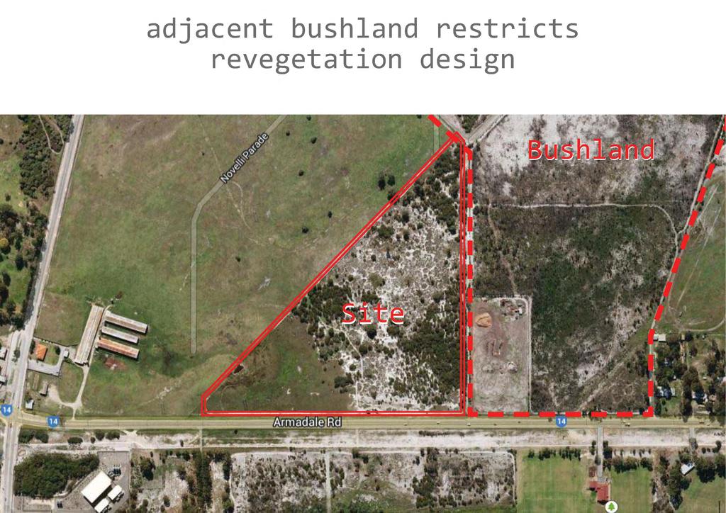
7 Integration of Bushfire Management Traditional fire management measures promote the physical separation of the development and the hazard. This can result in reduced amenity. Need for better management of the development interface.

8 Integration of Bushfire Management The most common issue is insufficient separation between vegetation and development. The minimum separation distance will normally be 20m being the building protection zone. On the development interface the subdivision road is often used.
.")
9 Vegetation Classification The Bushfire Regulations / AS3959 requires the classification of vegetation within developments. Applies to any vegetation more than 2,500sqm and 20m width (canopy). Applies to landscaping, revegetation buffers and existing vegetation.
 is the peak technical and educational fire safety organisation in Australia.")
10 Accreditation BAL assessments, hazard assessments and preparation of bushfire management plans are to be done by qualified bushfire consultants. The Fire Protection Association Australia (FPA Australia) is the peak technical and educational fire safety organisation in Australia. It has developed the Bushfire Planning and Design (BPAD) Accreditation Scheme which is proposed to be adopted in Western Australia.
11 Current Issues Provision of low fuel zone between vegetation and development. Building protection zone versus BAL setbacks. Confusion between management specifications for hazard separation zone versus BAL setbacks. Requirement for 3m firebreaks on lots/reserves of more than 0.5 hectares. Debate over what constitutes maintained parks and reserves and low threat vegetation.
12 Tree Spacings
13 Shrub Spacings
14 Various Plant Size Spacings
15 How BMPs Affect Reveg Design Revegetation Planners need to include a Bushfire Management Plan (BMP) Building Protection Zones (BPZ) and Hazard Protection Zones <100m (HSZ) Strategic firebreaks Water supply Multiple Access for fire response Includes Maintenance Need Bushfire Attack Level assessments (BALs).
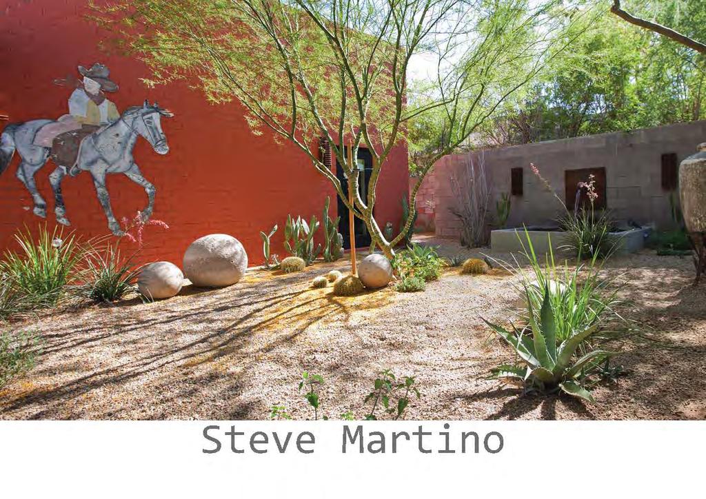
16 Revegetation Approaches How to meet revegetation needs while limiting fuel load (e.g. ecological/ social functions, number of plants). Maximise size of body of revegetation area, taking into account BPZs and HSZs. Use firebreaks and physical buffers (e.g. roads). Innovation needed in revegetating HSZs and BPZs. Consider alternative plantings, not a native design.

17
18 Revegetation Area Size and Shape Similar to edge effects Account for amount of HSZs Larger and rounder the area, the more area unrestricted for revegetation Longer and thinner the area, the more restricted revegetation
19

20
21 Revegetation Location Take into account surrounding land Liaise with Planners for best outcome

22

23
24 HSZ and BPZ Plant Density and Size Question purpose of revegetation to determine whether plant size or numbers is important Large Plants reduce plant numbers High numbers reduce plant size

25

26
27
28 Building Protection Zone Heavy revegetation restrictions on size and numbers Almost impossible for conventional revegetation Question revegetation purpose Need to consider non-traditional revegetation (e.g. xerophytic landscaping, exotic fire retardant plants)
29 Conclusion New bushfire planning guidelines will severely restrict revegetation planning in many projects. Revegetation Plans need to be integrated with BMPs. Much innovation now required to comply with new guidelines. Always question purpose of revegetation. Liaison with DFES and Planners needed.
Amendments to the Protected Plants Legislative Framework under the Nature Conservation Act 1992
 Amendments to the Protected Plants Legislative Framework under the Nature Conservation Act 1992 Protected plants overview: Protected plants are regulated under the Nature Conservation Act 1992 and subordinate
Local Area Key Issues Paper No. 13: Southern Hinterland townships growth opportunities
 Draft Sunshine Coast Planning Scheme Review of Submissions Local Area Key Issues Paper No. 13: Southern Hinterland townships growth opportunities Key Issue: Growth opportunities for Southern Hinterland
Appendix 2. Extracts from Ministry for the Environment Active Fault Guidelines 2003
 Extracts from Ministry for the Environment Active Fault Guidelines 2003 Published in July 2003 by the Ministry for the Environment Manatu Mo Te Taiao PO Box 10-362, Wellington, New Zealand ISBN: 0-478-18901
THE SEVILLE STRATEGY ON BIOSPHERE RESERVES
 THE SEVILLE STRATEGY ON BIOSPHERE RESERVES 1 VISION FOR BIOSPHERE RESERVES IN THE 21 ST CENTURY The international Seville Conference on Biosphere Reserves, organised by UNESCO, adopted a two-pronged approach,
ENVI Tutorial: Vegetation Analysis
 ENVI Tutorial: Vegetation Analysis Vegetation Analysis 2 Files Used in this Tutorial 2 About Vegetation Analysis in ENVI Classic 2 Opening the Input Image 3 Working with the Vegetation Index Calculator
15 March 2010 Re: Draft Native Vegetation of the Sydney Metropolitan Catchment Management Authority Area GIS layers and explanatory reports
 SYDNEY COASTAL COUNCILS GROUP Inc. C/- City of Sydney Council Level 14, 456 Kent Street GPO Box 1591, SYDNEY NSW 2001 Phone: (02) 9246 7791 Facsimile: (02) 9265 9660 Email: info@sydneycoastalcouncils.com.au
City of Manitou Springs
 March 2018 City of Manitou Springs Implementing Land Use tools to reduce and mitigate natural hazard risk Context & History Past Present Historic homes Older infrastructure Hillside development Creekside
Tourism. April State Planning Policy state interest guideline. Department of Infrastructure, Local Government and Planning
 Department of Infrastructure, Local Government and Planning State Planning Policy state interest guideline Tourism April 2016 Great state. Great opportunity. Preface Using this state interest guideline
LAND USE PLANNING AND RISK: LESSONS FROM THREE AUSTRALIAN PORT CITIES
 LAND USE PLANNING AND RISK: LESSONS FROM THREE AUSTRALIAN PORT CITIES Ken Granger Disaster Risk Scientist Slide No. 1 Land use planning is the single most important mitigation measure for limiting future
Statutory framework of the world network of biosphere reserves UNESCO General Conference 1996
 Statutory framework of the world network of biosphere reserves UNESCO General Conference 1996 Keywords: conservation, protected areas, biosphere reserves, policies, strategies. For the Mountain Forum's
Safety Regions, GIS and DM & Better SA by improved textual- & spatial visualisation. Jaap Smit Information Manager GEO, Safety Region IJsselland
 Safety Regions, GIS and DM & Better SA by improved textual- & spatial visualisation Jaap Smit Information Manager GEO, Safety Region IJsselland The Netherlands Area: 41,543 km 2 16,039 sq. mi Population:
Coastal Environment. Introduction. 4.1 Coastal Environment. Extent of Coastal Environment
 4 The primary objective (set out in Chapter 2) to be implemented by this Chapter is Objective 2.4 ; the following objectives are also relevant due to the objectives integrated nature: 2.1 Tāngata whenua
GIS in Community & Regional Planning
 GIS in Community & Regional Planning The The role role of of GIS GIS in in Re-writing the the Zoning Bylaw for for the the City City of of Vernon LandInfo Technologies Presentation Overview The GIS Initiative
The Governance of Land Use
 The Governance of Land Use Country fact sheet Czech Republic The planning system Levels of government and their responsibilities The Czech Republic is a unitary state with 3 levels of government: the national
Technical Drafting, Geographic Information Systems and Computer- Based Cartography
 Technical Drafting, Geographic Information Systems and Computer- Based Cartography Project-Specific and Regional Resource Mapping Services Geographic Information Systems - Spatial Analysis Terrestrial
Natura 2000 and spatial planning. Executive summary
 Natura 2000 and spatial planning Executive summary DISCLAIMER The information and views set out in this study are those of the author(s) and do not necessarily reflect the official opinion of the Commission.
CREATING A REPORT ON FIRE (April 2011)
") CREATING A REPORT ON FIRE (April 2011) The Fire Report feature on the NAFI website lets you create simple summaries of fire activity for areas of land in far northern Australia (north of 20 degrees where
CREATING A REPORT ON FIRE (April 2011) The Fire Report feature on the NAFI website lets you create simple summaries of fire activity for areas of land in far northern Australia (north of 20 degrees where
POLICY ISSUE (INFORMATION)
") POLICY ISSUE (INFORMATION) August 12, 2011 SECY-11-0112 FOR: FROM: SUBJECT: The Commissioners Michael R. Johnson, Director /RA/ Office of New Reactors STAFF ASSESSMENT OF SELECTED SMALL MODULAR REACTOR
POLICY ISSUE (INFORMATION) August 12, 2011 SECY-11-0112 FOR: FROM: SUBJECT: The Commissioners Michael R. Johnson, Director /RA/ Office of New Reactors STAFF ASSESSMENT OF SELECTED SMALL MODULAR REACTOR
GOAL 7 AREAS SUBJECT TO NATURAL DISASTERS AND HAZARDS. To protect life and property from natural disasters and hazards.
 GOAL 7 AREAS SUBJECT TO NATURAL DISASTERS AND HAZARDS A. GOALS: To protect life and property from natural disasters and hazards. B. POLICIES: 1. Floodplains shall be maintained as natural drainage-ways.
Requirements for a Dark Skies Designation RLEP
 Requirements for a Dark Skies Designation RLEP 2017 Why Consider a Dark Skies Designation? Demonstrates a public commitment to preserving the quality of night skies Is a valuable credential for promoting
International Guidelines on Access to Basic Services for All
 International Guidelines on Access to Basic Services for All Presentation and initials lessons from implementation Accessibility to services in regions and cities : measures and policies, OECD 18 June
9. GEOLOGY, SOILS, AND MINERALS
 June 28, 2018 Page 9-1 9. GEOLOGY, SOILS, AND MINERALS This EIR chapter describes the existing geological, soil, and mineral conditions in the planning area. The chapter includes the regulatory framework
SHORELINE PROVISIONS RESIDENTIAL LOT
 By-law Discussion Paper #1 SHORELINE PROVISIONS RESIDENTIAL LOT Meeting Dates: April 6 to May 29, 2000 and February 13, 2001 Official Plan Policies Intent preserve ribbon of life preserve shoreline character
PROTOCOL ON THE IMPLEMENTATION OF THE ALPINE CONVENTION OF 1991 RELATING TO SPATIAL PLANNING AND SUSTAINABLE DEVELOPMENT
 PROTOCOL ON THE IMPLEMENTATION OF THE ALPINE CONVENTION OF 1991 RELATING TO SPATIAL PLANNING AND SUSTAINABLE DEVELOPMENT SPATIAL PLANNING AND SUSTAINABLE DEVELOPMENT" PROTOCOL Preamble The Republic of
6 MACRAES MINING PROJECT MINERAL ZONE
 6 MACRAES MINING PROJECT MINERAL ZONE 6.1 ZONE STATEMENT The Macraes Mining Zone applies to the area of land controlled by Macraes Mining Limited and included in Mining Permit 41-064 at the date of public
NATURE AND EXTENT OF PROPOSED DEVELOPMENT. Amount of Development Development Zones Distribution of Density Policies
 NATURE AND EXTENT OF PROPOSED DEVELOPMENT Amount of Development Development Zones Distribution of Density Policies DRAFT POOLBEG PLANNING SCHEME Amount of Development 78 4.1 The rationale for the overall
Legal problems of environmental management. Spatial planning and space management. M. Gajewski 2014 / 2015
 Legal problems of environmental management Spatial planning and space management M. Gajewski 2014 / 2015 Course contents (in brief) Constitutional basis of the environment protection system. General principles
MEMORANDUM OF UNDERSTANDING. between the ASSOCIATION OF AMERICAN STATE GEOLOGISTS. and the U.S. DEPARTMENT OF THE INTERIOR OFFICE OF SURFACE MINING
 MEMORANDUM OF UNDERSTANDING between the ASSOCIATION OF AMERICAN STATE GEOLOGISTS and the U.S. DEPARTMENT OF THE INTERIOR OFFICE OF SURFACE MINING MEMORANDUM OF UNDERSTANDING between the ASSOCIATION OF
Exploring GIS Potential for Northwestern Ontario Land Information Ontario
 Exploring GIS Potential for Northwestern Ontario Land Information Ontario May 13, 2015 The LIO Vision LIO Vision: That all geographic information about Ontario is fully integrated and accessible LIO Goal:
ACTION PLAN FOR WORLD HERITAGE IN LATIN AMERICA AND THE CARIBBEAN ( )
") Annex ACTION PLAN FOR WORLD HERITAGE IN LATIN AMERICA AND THE CARIBBEAN (2014-2024) The current Regional Action Plan for Latin America and the Caribbean for 2014-2024 has been elaborated by the State Parties
Annex ACTION PLAN FOR WORLD HERITAGE IN LATIN AMERICA AND THE CARIBBEAN (2014-2024) The current Regional Action Plan for Latin America and the Caribbean for 2014-2024 has been elaborated by the State Parties
7.34 Spartina (Spartina anglica)
") 7.34 Spartina (Spartina anglica) Why is it a threat? Spartina is a sward forming grass that originates from the United Kingdom. It grows from underground rhizomes. The rhizomes break off and establish
7.34 Spartina (Spartina anglica) Why is it a threat? Spartina is a sward forming grass that originates from the United Kingdom. It grows from underground rhizomes. The rhizomes break off and establish
PROMOTING NATURE CONSERVATION AND SUSTAINABLE AGRICULTURAL DEVELOPMENT IN THE RURAL AREAS OF HONG KONG
 1 PROMOTING NATURE CONSERVATION AND SUSTAINABLE AGRICULTURAL DEVELOPMENT IN THE RURAL AREAS OF HONG KONG Director of Agriculture, Fisheries and Conservation Dr. LEUNG Siu-fai A STONE S THROW AWAY FROM
Natural Resource Management. Northern Tasmania. Strategy. Appendix 2
 Natural Resource Management Strategy Northern Tasmania 2015 2020 Appendix 2 Appendix 2 Appendix 2. Carbon Planting Spatial Prioritisation In support of this Strategy s development and implementation, work
Duralie Open Pit Modification
 Duralie Open Pit Modification Environmental Assessment SECTION 5 REHABILITATION STRATEGY TABLE OF CONTENTS 5 REHABILITATION STRATEGY 5-1 5.1 EXISTING DCM REHABILITATION 5-1 5.1.1 Rehabilitation Principles
Regulations concerning protection of Bjørnøya Nature Reserve in Svalbard
 Regulations concerning protection of Bjørnøya Nature Reserve in Svalbard Laid down by the Royal Decree of 16 August 2002 pursuant to sections 12 and 17 of the Act of 15 June 2001 No. 79 relating to the
CHAPTER GEOLOGICALLY HAZARDOUS AREAS Applicability Regulations.
 CHAPTER 19.07 GEOLOGICALLY HAZARDOUS AREAS 19.07.010 Applicability. Geologically hazardous areas may pose a threat to the health and safety of citizens when incompatible development is sited in areas of
1.1 What is Site Fingerprinting?
 Site Fingerprinting Utilizing GIS/GPS Technology 1.1 What is Site Fingerprinting? Site fingerprinting is a planning tool used to design communities where protection of natural resources is the primary
THE IMPACT OF LANDSLIDE AREAS ON MUNICIPAL SPATIAL PLANNING
 THE IMPACT OF LANDSLIDE AREAS ON MUNICIPAL SPATIAL PLANNING Jarosław Bydłosz, PhD Faculty of Mining Surveying and Environmental Engineering AGH University of Science and Technology e-mail: bydlosz@agh.edu.pl
The Governance of Land Use
 The planning system Levels of government and their responsibilities The Governance of Land Use Country fact sheet Germany Germany is a federal country with four levels of government. Below the national
LANDUSE APPLICATIONS OF EARTHQUAKE HAZARD MAPS CALIFORNIA EXPERIENCE
 LANDUSE APPLICATIONS OF EARTHQUAKE HAZARD MAPS CALIFORNIA EXPERIENCE Thomas C. Vlasic Vice President Spangle Associates Portola Valley, California INTRODUCTION The focus of this report is primarily on
Orica Australia Pty Ltd Ammonium Nitrate Facility Upgrade
 Orica Australia Pty Ltd Ammonium Nitrate Facility Upgrade January 2010 Revision 0 Contents 1. Introduction 1 1.1 Purpose 1 1.2 Objectives 1 1.3 Relevant Environmental Legislation, Guidelines and Policies
COMMUNITY DEVELOPMENT DEPARTMENT POLICY & PROCEDURE
 COMMUNITY DEVELOPMENT DEPARTMENT POLICY & PROCEDURE Policy No: DSP-OO3 Release Date: January 1, 2014 Effective Date: January 1, 2014 Revision Date: March 1, 2018 TITLE: The City Policy for Site Specific
COMMENTS ON THE CONSERVATION STATUS OF SENECIO VELLEIOIDES (FOREST GROUNDSEL) IN TASMANIA
 IN TASMANIA") COMMENTS ON THE CONSERVATION STATUS OF SENECIO VELLEIOIDES (FOREST GROUNDSEL) IN TASMANIA Mark Wapstra Environmental Consulting Options Tasmania, 28 Suncrest Avenue, Lenah Valley, Tasmania 7008; mark@ecotas.com.au
COMMENTS ON THE CONSERVATION STATUS OF SENECIO VELLEIOIDES (FOREST GROUNDSEL) IN TASMANIA Mark Wapstra Environmental Consulting Options Tasmania, 28 Suncrest Avenue, Lenah Valley, Tasmania 7008; mark@ecotas.com.au
SPLAN-Natura Towards an integrated spatial planning approach for Natura th January, 2017 Brussels. Commissioned by DG Environment
 SPLAN-Natura 2000 Towards an integrated spatial planning approach for Natura 2000 Commissioned by DG Environment 17 th January, 2017 Brussels V. Simeonova (Ph.D.) Drivers towards integrating Biodiversity
The Wanaka High Density Residential Zone Monitoring Report
 182 2011 The Wanaka High Density Residential Zone Monitoring Report Policy and Planning Queenstown Lakes District Council September 2011 183 Executive Summary This monitoring report has been formulated
- Forest Fires - The Good, the Bad and the Ugly -
 Lesson Plan - Forest Fires - The Good, the Bad and the Ugly - OBJECTIVE: Students will: Identify the risks of fighting forest fires Determine who becomes involved when a fire is out of control Explain
GIS AND REMOTE SENSING FOR OPEN SPACE PROTECTION ENVIRONMENTAL MANAGEMENT DEPARTMENT
 GIS AND REMOTE SENSING FOR OPEN SPACE PROTECTION ENVIRONMENTAL MANAGEMENT DEPARTMENT 22 nd May 2009 1 Introduction It is said that more than 80% of the City s activities throughout the world are spatially
Auckland Council District Plan Hauraki Gulf Islands Section Operative 2013 Proposed plan modification no. 1: Plan Change
 Page 1 Auckland Council District Plan Hauraki Gulf Islands Section Operative 2013 Proposed plan modification no. 1: Plan Change Date of public notification: 31 May 2013 Closing date for submission: 1 July
Statutory Framework of Biosphere Reserves. The Statutory Framework of the World Network of Biosphere Reserves
 Page 1 of 5 The Statutory Framework of the World Network of Biosphere Reserves Introduction Article 1 - Definition Article 2 - World Network of Biosphere Reserves Article 3 - Functions Article 4 - Criteria
What are the issues?
 Water Quality along Lake Huron What are the issues? Lake Huron Water Quality Algal fouling Irregular, less frequent, less widespread, but some significant local events Influences Tributaries contribute;
GIS 101: AN INTRODUCTION TO GAS INSULATED SUBSTATIONS
 GIS 101: AN INTRODUCTION TO GAS INSULATED SUBSTATIONS COURSE September 28-29, 2017 Sheraton Denver Downtown Hotel Denver, CO TAG US #EUCIEvents FOLLOW US @EUCIEvents EUCI is authorized by IACET to offer
1:30 2:00 Tangible Examples of NVC Uses from Monitoring, Mapping, and Habitat Modeling. (Todd Keeler- Wolf, ESA Panel)
") 1:30 2:00 Tangible Examples of NVC Uses from Monitoring, Mapping, and Habitat Modeling. (Todd Keeler- Wolf, ESA Panel) Habitat Modeling for Mojave Ground Squirrel: a rare species of the Western Mojave
1:30 2:00 Tangible Examples of NVC Uses from Monitoring, Mapping, and Habitat Modeling. (Todd Keeler- Wolf, ESA Panel) Habitat Modeling for Mojave Ground Squirrel: a rare species of the Western Mojave
Phase 1 Geoscientific Preliminary Assessment Southern Ontario, Sedimentary Communities
 Phase 1 Geoscientific Preliminary Assessment Southern Ontario, Sedimentary Communities Presented to: Community Liaison Committees (Brockton, Huron-Kinloss, South Bruce) March 2014 Project Description»
REQUEST FOR PROPOSALS CLOSING DATE:
 Request for Proposals 110 Westlake Drive City of West Lake Hills 110 Westlake Drive REQUEST FOR PROPOSALS CLOSING DATE: Tuesday, October 23, 2018 City of West Lake Hills Request for Proposals 1 I. INTRODUCTION
Factors That Shape Places. Sackville North
 Factors That Shape Places Sackville North Stage 3 Geography As urban Sydney sprawls in all directions, the North West is changing dramatically. This Geographical Inquiry will focus on the connections between
Making maps: Traditions and perceptions in Europe. European spatial planning and cartographic representations
 ESPON Create Europe! Making maps: Traditions and perceptions in Europe Dr. Stefanie Dühr University of the West of England, Bristol, UK European spatial planning and cartographic representations Scenarios.
Natural Resource Management Strategy. Southern Tasmania. Summary. Natural Resource Management Strategy for Southern Tasmania Summary
 Natural Resource Management Strategy Summary Southern Tasmania 2015 2020 Natural Resource Management Strategy for Southern Tasmania 2015 2020 - Summary i Disclaimer In developing this Strategy, every effort
NZQA unit standard New US6 to replace and version 1 Page 1 of 5
 Page 1 of 5 Title Demonstrate knowledge of mining methods, and analyse and select plant for metalliferous underground extraction Level 6 Credits 20 Purpose People credited with this unit standard are able
Contents. Ipswich City Council Ipswich Adopted Infrastructure Charges Resolution (No. 1) Page
 Page") Ipswich City Council Ipswich Adopted Infrastructure Charges Resolution (No. 1) 2014 Contents Page Part 1 Introduction 3 1. Short title 3 2. Commencement 3 3. Sustainable Planning Act 2009 3 4. Purpose
Ipswich City Council Ipswich Adopted Infrastructure Charges Resolution (No. 1) 2014 Contents Page Part 1 Introduction 3 1. Short title 3 2. Commencement 3 3. Sustainable Planning Act 2009 3 4. Purpose
CERTIFIED RESOLUTION. introduction: and dated May 29, 2017, as attached, as appropriate
 15322 Buena Vista Avenue, White Rock BC, Canada V4B 1Y6 www.whiterockcity.ca City of White Rock P: 604.541.22121 F: 604.541.9348 /2tC% City Clerk s Office IT E ROC K June 13,2017 Stephanie Lam, Deputy
DBSA Knowledge Week Yusuf Patel South African Planning Institute
 Sustainable Human Settlements - Institutional Issues DBSA Knowledge Week Yusuf Patel South African Planning Institute 20 October 2010 Spatial Planning for Long Term Apartheid engineered spatial economy
Comprehensive Community Planning
 Comprehensive Community Planning Session Three: Preparing to Plan Part Two - Day 2 AM - Zoning and Land Use Decision Continued How does the Land Use Plan connect to the CCP? LUP direction included in /
Food Safety Management System
 Introduction The company has planned, established, documented and implemented a food safety management system for the site, in order to continually improve its effectiveness in accordance with legislation,
Council Roadside Reserves Environmental Grants
 Roadside Reserves Environmental Grants The Roadside Reserves (CRR) project is a three year project funded by the NSW Environmental Trust and managed by Local Government NSW to help councils towards best
Factors that Shape Places Stage 3 Geography
 Factors that Shape Places Stage 3 Geography Summary This unit is written for Stage 3 "Factors that shape places". It is a Geographical Inquiry, enabling students to work through the 3 stages of inquiry;
OFFICIAL GAZETTE OF THE REPUBLIC OF KOSOVA / No. 30 / 23 AUGUST 2013, PRISTINA LAW NO. 04/L-174 ON SPATIAL PLANNING LAW ON SPATIAL PLANNING
 OFFICIAL GAZETTE OF THE REPUBLIC OF KOSOVA / No. 30 / 23 AUGUST 2013, PRISTINA LAW NO. 04/L-174 ON SPATIAL PLANNING Assembly of Republic of Kosovo; Pursuant to Article 65 (1) of the Constitution of Republic
Date: June 19, 2013 Meeting Date: July 5, Consideration of the City of Vancouver s Regional Context Statement
 Section E 1.5 To: From: Regional Planning and Agriculture Committee Lee-Ann Garnett, Senior Regional Planner Planning, Policy and Environment Department Date: June 19, 2013 Meeting Date: July 5, 2013 Subject:
Fluvial Geomorphic Guidelines
 Fluvial Geomorphic Guidelines FACT SHEET I: GEOMORPHOLOGICAL HAZARDS CONFINED AND UNCONFINED WATERCOURSES Channel migration and erosion can create substantial risk to inappropriately located infrastructure
Periodic Inspection and Testing of Electrical Installations Sample Test ( ) Version 1.3 July 2018
 Version 1.3 July 2018") Periodic Inspection and Testing of Electrical Installations Sample Test (2391-051) Version 1.3 July 2018 Sample Questions Version and date Change detail Section 1.3 July 2018 Modified questions/answers
Periodic Inspection and Testing of Electrical Installations Sample Test (2391-051) Version 1.3 July 2018 Sample Questions Version and date Change detail Section 1.3 July 2018 Modified questions/answers
The AIR Bushfire Model for Australia
 The AIR Bushfire Model for Australia In February 2009, amid tripledigit temperatures and drought conditions, fires broke out just north of Melbourne, Australia. Propelled by high winds, as many as 400
EXCEPTIONAL CLOSURES - CHECKLIST FOR GOOSTREY COMMUNITY PRIMARY SCHOOL
 EXCEPTIONAL CLOSURES - CHECKLIST FOR GOOSTREY COMMUNITY PRIMARY SCHOOL To be reviewed Spring 2018 It is the policy of Goostrey Community Primary School to remain open unless we are forced to close because
Wildfires a burning issue for utilities in times of climate change
 Wildfires a burning issue for utilities in times of climate change More than AUD 500 million was the cost to utility companies to settle claims after power lines, blown over in a hot windstorm, were linked
3l NATURAL HAZARDS AND UNSTABLE GROUND
 Page 1 of Section 3l 3l NATURAL HAZARDS AND UNSTABLE GROUND 3l.1 Introduction A natural hazard is the result of natural processes that form, shape and change the environment and interact or potentially
A Method for Mapping Settlement Area Boundaries in the Greater Golden Horseshoe
 A Method for Mapping Settlement Area Boundaries in the Greater Golden Horseshoe Purpose This paper describes a method for mapping and measuring the lands designated for growth and urban expansion in the
Randall W. Parkinson, Ph.D., P.G. Institute of Water and Environment Florida International University
 An Update on Adaptation Action Activities Undertaken Since Completion of the City of Satellite Beach (FL) Vulnerability Assessment to Rising Seas (2010) Randall W. Parkinson, Ph.D., P.G. Institute of Water
Stabilization Study. Prepared For: The Town of Bethlehem. Henry Hudson Park Shoreline Stabilization Study. June 2011
 Henry Hudson Park Shoreline Stabilization Study Prepared For: The Town of Bethlehem 1 Company Introduction - OCC Ocean and Coastal Consultants (OCC) is a 50 person engineering consulting firm that specializes
PUBLIC HEALTH ASSOCIATION OF AUSTRALIA Strategic Plan
 PUBLIC HEALTH ASSOCIATION OF AUSTRALIA Strategic Plan March 2017 20 Napier Close Deakin ACT Australia 2600 PO Box 319 Curtin ACT Australia 2605 Table of Contents Introduction... 2 Vision for a healthy
Page G Crow Wing County Multi-Hazard Mitigation Plan, 2017
 Table G - 10. s Identified by the () (From Crow Wing County Master Chart) 1 5 All- Hazards All- Hazards Work to ensure that all Crow Wing County residents are aware of and sign-up for the County s Emergency
Factors That Shape Places Sackville North
 Factors That Shape Places Sackville North As urban Sydney sprawls in all directions, the North West is changing dramatically. This Geographical Inquiry will focus on the connections between people and
INTEGRATION OF BUILT AND NATURAL ENVIRONMENTAL DATASETS WITHIN NATIONAL SDI INITIATIVES
 UNITED NATIONS E/CONF.97/6/IP. 38 and IP. 39 ECONOMIC AND SOCIAL COUNCIL Seventeenth United Nations Regional Cartographic Conference for Asia and the Pacific Bangkok, 18-22 September 2006 Item 7 of the
Green Chemistry & Related Regulatory Developments
 Green Chemistry & Related Regulatory Developments Dr. Rashmi Naidu Director, Technical Services NS Support Services Pvt. Ltd (Technical Support Centre to SSS (Europe) AB, Sweden) Industrial Green Chemistry
Chemical Hygiene Plan for Laboratories
 SAFETY POLICIES AND PROCEDURES MANUAL LABORATORY SAFETY 4.12.1 OVERVIEW Washington State University has developed the chemical hygiene plan to aid units in promoting a high standard of health and safety.
Ecosystems at Risk Case Study 1 Coastal Sand Dunes- Stockton Bight Introduction
 Ecosystems at Risk Case Study 1 Coastal Sand Dunes- Stockton Bight Introduction 1. What are Coastal Sand Dune ecosystems? 2. What are the natural functions of Coastal Sand Dunes? 3. Why are the Stockton
Lorna V Inniss, Ph.D SAGE Workshop, New York City
 Lorna V Inniss, Ph.D SAGE Workshop, New York City 2014-05-21 Why me? The globally recognized success of the Barbados ICZM programme has generated requests for technical assistance and CD from many Governments
Towards a policy for exemption of low risk, commercially valuable cultivars of declared plants
 Towards a policy for exemption of low risk, commercially valuable cultivars of declared plants Ross Meffin and David Cooke Biosecurity SA MAY 2018 REVIEW OF DECLARED PLANTS First complete review since
Local Development Pilot Project: Island of Cres. Ranka Saračević Würth, Ministry of Culture, Republic of Croatia
 Local Development Pilot Project: Island of Cres Ranka Saračević Würth, Ministry of Culture, Republic of Croatia BACKGROUND, RATIFICATION OF THE FARO CONVENTION BY REPUBLIC OF CROATIA The Framework Convention
A/AC.105/C.1/2016/CRP.17
 19 February 2016 English only Committee on the Peaceful Uses of Outer Space Scientific and Technical Subcommittee Fifty-third session Vienna, 15-26 February 2016 Item 11 of the provisional agenda Space
APPENDIX C BIODIVERSITY OFFSET STRATEGY
 APPENDIX C BIODIVERSITY OFFSET STRATEGY Submissions Report 17 076 Final v1 C I Submissions Report C.1 INTRODUCTION This Biodiversity Offset Strategy (BOS) outlines a broad approach for meeting the offset
MULTI-HAZARD RISK ASSESSMENT AND DECISION MAKING
 MULTI-HAZARD RISK ASSESSMENT AND DECISION MAKING JULINDA KEÇI Epoka University Logo of the institution CONTENT: Introduction Multi Hazard Risks Multi-Hazard Risk Assessment Quantitative Assessment Event
5.2. Historic heritage. Photo: Vaughan Homestead, Long Bay Regional Park, Auckland. (Source: ARC). Historic heritage
. Historic heritage") Photo: Vaughan Homestead, Long Bay Regional Park, Auckland. (Source: ARC). 274 Hazards and heritage Contents 5.2 Introduction 276 monitoring programmes 276 The state of historic heritage 277 Heritage items
Photo: Vaughan Homestead, Long Bay Regional Park, Auckland. (Source: ARC). 274 Hazards and heritage Contents 5.2 Introduction 276 monitoring programmes 276 The state of historic heritage 277 Heritage items
New approaches to warning: the role of radar
 New approaches to warning: the role of radar John Handmer Centre for Risk and Community Safety, RMIT University Today The risk we want to reduce, and how much impact can we have on the risk of disasters?
New Zealand s Next Top Model: integrating tsunami modelling into land use planning
 New Zealand s Next Top Model: integrating tsunami modelling into land use planning Wendy Saunders (MZNZPI), Gegar Prasetya, Graham Leonard GNS Science, Lower Hutt, w.saunders@gns.cri.nz In April 2011 a
What s the problem? A Modern Odyssey in Search of Relevance. The search for relevance. Some current drivers for new services. Some Major Applications
 A Modern Odyssey in Search of Relevance FIG Working Week, Athens, 24 May 2004 Paul Kelly ANZLIC Executive Director The search for relevance 1. New expectations for spatial services 2. Are we ready to meet
Safety Guidelines for the Chemistry Professional: Understanding Your Role and Responsibilities
 Safety Guidelines for the Chemistry Professional: Understanding Your Role and Responsibilities Kenneth P. Fivizzani Committee on Chemical Safety/ Division of Chemical Health & Safety August 22, 2017 Introduction
Draft Biodiversity, Fire, and Fuels Integrated Plan
 Marin Municipal Water District Draft Biodiversity, Fire, and Fuels Integrated Plan September 15, 2016 One Embarcadero Center, Suite 740 San Francisco, CA 94111 650-373-1200 www.panoramaenv.com Marin Municipal
The Globally Harmonized System (GHS) for Hazard Classification and Labelling. Development of a Worldwide System for Hazard Communication
 for Hazard Classification and Labelling. Development of a Worldwide System for Hazard Communication") The Globally Harmonized System (GHS) for Hazard Classification and Labelling Development of a Worldwide System for Hazard Communication Why is the GHS needed? No country has the ability to identify and
The Globally Harmonized System (GHS) for Hazard Classification and Labelling Development of a Worldwide System for Hazard Communication Why is the GHS needed? No country has the ability to identify and
D14. Volcanic Viewshafts and Height Sensitive Areas Overlay
 D14. Volcanic Viewshafts and Height Sensitive Areas Overlay D14.1. Overlay description The purpose of the Volcanic Viewshafts and Height Sensitive Areas Overlay is to appropriately protect significant
Fire Fighting Chemicals Group Standard HSR002573
 Fire Fighting Chemicals Group Standard 2017 - HSR002573 GROUP STANDARD UNDER THE HAZARDOUS SUBSTANCES AND NEW ORGANISMS ACT 1996 Fire Fighting Chemicals Group Standard 2017 Pursuant to clause 5 of Schedule
Biosphere Reserves : Bureaucratic Label or Sustainable Landscape. KAERA COETZER, BFN Erasmus, ETF Witkowski
 Biosphere Reserves : Bureaucratic Label or Sustainable Landscape BACKGROUND, CHALLENGES & THE K2C CONTEXT KAERA COETZER, BFN Erasmus, ETF Witkowski Biosphere Reserves: The Background UNESCO designation:
Exploring the provision of ecosystem services through rural landscape management: a development of conceptual framework
 Exploring the provision of ecosystem services through rural landscape management: a development of conceptual framework Rovai M., Bartolini F., Fastelli L., Brunori G. Department of Agriculture, Food and