Factors That Shape Places Sackville North
|
|
|
- Laurence Stevens
- 6 years ago
- Views:
Transcription

1 Factors That Shape Places Sackville North As urban Sydney sprawls in all directions, the North West is changing dramatically. This Geographical Inquiry will focus on the connections between people and nature at Brewongle Environmental Education Centre and its surrounds at Sackville North on the Hawkesbury River in North West Sydney. Inquiry Questions: How does the natural environment influence people and places at Sackville North? How have people changed the natural environment at Sackville North and the local Hawkesbury River Catchment? How do bushfires shape the natural environment at impact where people live in Sackville North? Health and Safety Issues As you are working out in the field you need to be aware that: Ground material is often covered in moss and can be very slippery. Vines and dense undergrowth can trip. Fallen trees can be rotten and weak. Some animals can deliver painful or venomous bites. On slopes, rocks can be easily dislodged. Outcomes GE3-1: GE3-2: Describes the diverse features and characteristics of places and environments Explains interactions and connections between people, places and environments GE3-3: Compares and contrasts influences on the management of places and environments GE3-4: Acquires, processes and communicates geographical information using geographical tools for inquiry Student Name:
2 Inquiry Aim: Stage 3 Geography The aim of this Geographical Inquiry is to investigate the factors that shape places, with a focus on the connections between people and nature. You will be researching Sackville North in Northwest Sydney, using Brewongle EEC as a case study. Pre-Visit Lesson One: The Study Site SIX Maps has been developed by the NSW Department of Land and Property. It provides access to cadastral (land and property boundaries) and topographic (hills and valleys) information, satellite data and aerial photography. Use SIX Maps to complete the following tasks. 1. On SIX Maps, type in Sackville North. 2. Click on Basemaps (top right of page) and drag the tab down until you can see the Street and Suburb names. 3. Zoom out and fly around until you find your local Suburb. 4. Click on Basemaps and move the tab back up until you can see the satellite image. 5. Zoom out to a scale around 1: (you can see this in the bottom left of screen). Follow the Hawkesbury Nepean River upstream from the ocean to Warragamba Dam. By holding a piece of string to your computer screen, estimate the length of the Hawkesbury Nepean River.
3 Pre-Visit Lesson Two: Geographical Questions Geographical questions are questions which help you identify the information you need to answer the inquiry questions. Your inquiry questions are written on Page 1. Brainstorm: What are some geographical questions you might ask for this Inquiry? Example: Why might people choose to live in a specific area or suburb? Geographical Question 1: Geographical Question 2: Geographical Question 3: Geographical Question 4: Geographical Question 5:
4 Pre-Visit Lesson Three: Planning Your Inquiry Answer the following questions for each of the Geographical Questions you came up with last lesson: 1. What information is needed to answer this geographical question and where can you find that information? 2. What are the geographical tools you need to access the information? 3. Develop a system for recording the information you get.
5 Fieldwork Activity One: Topography & Water Quality You will walk from Sackville Ferry Road to the Hawkesbury River. 1. How many examples of stormwater runoff did you see? 2. Describe the examples of stormwater runoff you saw. Take photos if possible. 3. Were the examples of stormwater runoff mostly along the track or were they in the bush? Hawkesbury River Water Quality Poor Average Healthy Result ph level Salinity >1000 ppm >500 ppm ppm Dissolved Oxygen <2mg/L 2-4mg/L >5mg/L Turbidity >100NTUs NTUs <50NTUs
6 Sketch a Cross Section of the hill you just walked down. Start with Sackville Ferry Road on the left of the page and the Hawkesbury River on the right. Include a scale. Label the following: Natural Features (trees, shrubs, groundcover), Human Impacts and Erosion.
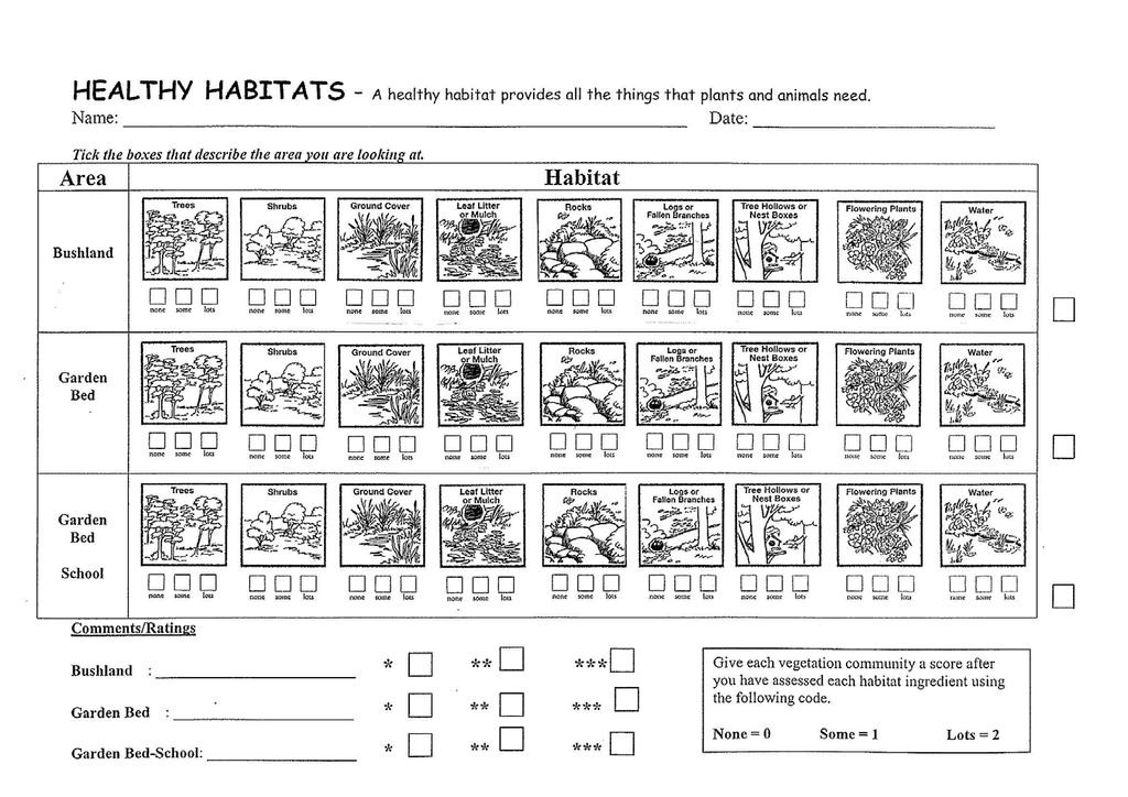
7 Fieldwork Activity Two: Habitat Assessment Stage 3 Geography In your 10 metre quadrat: Parameter Units Equipment Result Average Plant Height Metres Measuring Tape Plant Diversity Number of different species Plant ID Chart Air Temperature Degrees Celsuis Thermometer Humidity % Hygrometer Aspect Degrees Compass Bird Diversity Number of different species Sound Map: On the following blank page: 1. Make an X in the centre of the page to represent your location. 2. Sit separately and silently in your own space within your quadrat. 3. Use symbols, words or other marks to represent the sounds you hear around you. Include man-made and natural sounds. Make a key for your symbols or letters. Eg. C = Car, T = Truck, B = Bird, etc.
8 Sound Map KEY
9

10 Fieldwork Activity Three: Vegetation & Bushfire Create a Nature Map with leaves and other plant material to show the layers and density of two different sites. Take a photo of both Nature Maps and insert them later into your worksheet. Site A The Gully Nature Map: Use your nature map and the results of the burn test to evaluate the moisture content and the density of the shrub layer at Site A. Circle the box below that corresponds to your results. Shrub Layer Density Moisture Content <30% 30-70% >70% Wet LOW-MODERATE HIGH VERY HIGH Moist HIGH VERY HIGH SEVERE Dry VERY HIGH SEVERE EXTREME
11 Site B The Ridge Nature Map: Use your nature map and the results of the burn test to evaluate the moisture content and the density of the shrub layer at Site A. Circle the box below that corresponds to your results. Shrub Layer Density Moisture Content <30% 30-70% >70% Wet LOW-MODERATE HIGH VERY HIGH Moist HIGH VERY HIGH SEVERE Dry VERY HIGH SEVERE EXTREME
12 Fieldwork Summary Activity One: Topography and Water Quality: How does the environment influence people and places at Sackville North? Activity Two: Habitat Assessment: How have people changed the site around Brewongle EEC, Sackville North and the local Hawkesbury River Catchment? Activity Three: Vegetation and Bushfires: How does bushfire risk change with topography? Would the Ridge or the Gully be a safer place to live?
13 Post-Visit Lesson One: Population Growth Use legitimate websites to source secondary data and other statistical information about population growth in Northwest Sydney and the Greater Sydney Region. Evaluate and summarise the data and information into 5 key points. Secondary data is data collected by someone other than you or for a purpose other than your research. Legitimate websites include the Australian Bureau of Statistics and State and Local Government
14 5. Develop and conduct a survey of community members about their thoughts on the impact of population increase on our nature reserves (positive and negative). Include impacts on people, plants, animals and the Hawkesbury River. Write 5-10 well structured questions and practice doing the survey yourself. Your survey might use or online networks, or in person (with an adult). You may survey people you know who live in the area or local businesses. Survey at least 3 people.
15 Post-Visit Lesson Two-Three: Processing the Data Stage 3 Geography Below is a list of Geographical Tools used to collate, review and evaluate data and information. Choose at least 5 of these tools to analyse and present your data in a Word Document. The information you create here will be used in your documentary assessment task. Using a topographic map or satellite image as a base map, locate Brewongle and identify surrounding natural environmental features. Collate data from your in-depth study into a table to summarise your findings. Create flowcharts to demonstrate your understanding of the ways the environment influences people and places. Assemble and annotate photographs to provide a visual representation of the site. Analyse and label interconnections. Develop consequences charts to explain human impacts (positive and negative). Show the impacts on Google Tour Builder. Use photos taken on the day to match parts of the tracks we walked. Use a T-chart to represent data on advantages and disadvantages of population increases in Northwest Sydney. Construct a flow chart or concept map to explain the role of government, and other major stakeholders in sustainably developing Northwest Sydney and protecting our nature reserves. Conduct a search for Brewongle EEC on the Rural Fire Service Bushfire Prone Land Tool. Discuss how the results will change with seasons throughout the year.
16 Assessment Task: Stage 3 Geography Communicating Geographical Information Work in small groups to develop a 5-6 minute documentary on the possible effects of population increase on our nature reserves using Sackville North as a case study. Your documentary should include: A clear description of the various land uses around Brewongle EEC and an evaluation of some of the consequences for the environment; Tools to support your information, such as maps, satellite images, graphs, statistics, flowcharts, labelled photographs, diagrams, illustrations/sketches and other labelled visual representations; Information on the traditional use of the place by Darug people; Information on the types of land use by early European settlers; A description of the role of government in organising or managing the place as well as the perspectives of other stakeholders, for example developers, conservationists, recreationists and local residents; An evaluation of the potential impact of bushfire on the local area; A description and justification of a course of action to decrease the impact of changes to the natural environment around Brewongle EEC. Please refer to the Stage 3 Geography page on the Brewongle website for extra resources, including a Storyboard Template and a How To Guide for imovies.
Factors That Shape Places. Sackville North
 Factors That Shape Places Sackville North Stage 3 Geography As urban Sydney sprawls in all directions, the North West is changing dramatically. This Geographical Inquiry will focus on the connections between
The Blacktown Fishing Bat
 Factors That Shape Places The Blacktown Fishing Bat As urban Sydney sprawls in all directions, the Blacktown Local Government Area is changing dramatically. This Geographical Inquiry will focus on the
Water in the World. Hawkesbury Nepean River
 Hawkesbury Nepean River The Hawkesbury Nepean River has been a vital part of our landscape for many thousands of years. It played a key role in the lives of Indigenous Darug People living in the area,
Hawkesbury/Nepean River
 Hawkesbury/Nepean River The Hawkesbury Nepean River has been a vital part of our landscape for any thousands of years. It played a key role in the lives of Indigenous Darug People living in the area, the
Factors that Shape Places Stage 3 Geography
 Factors that Shape Places Stage 3 Geography Summary This unit is written for Stage 3 "Factors that shape places". It is a Geographical Inquiry, enabling students to work through the 3 stages of inquiry;
Factors that Shape Places (Blacktown) Stage 3 Geography
 Stage 3 Geography") Factors that Shape Places (Blacktown) Stage 3 Geography Summary This unit is written for Stage 3 "Factors that shape places". It is a Geographical Inquiry, enabling students to work through the 3 stages
Factors that Shape Places (Blacktown) Stage 3 Geography Summary This unit is written for Stage 3 "Factors that shape places". It is a Geographical Inquiry, enabling students to work through the 3 stages
Biophysical Interactions
 1 River Ecology Senior Geography Biophysical Interactions Checking the Pulse of the Hawkesbury River Name 2 River Ecology Senior Geography Senior Geography Outcomes PRELIMINARY COURSE OUTCOMES P2 describes
The Earth's Environment - A Marshy Mystery Stage 2 Geography
 The Earth's Environment - A Marshy Mystery Stage 2 Geography Summary This unit is written for Stage 2 "The Earth's Environment". It is a Geographical Inquiry, enabling students to work through the 3 stages
STAGE 2 GEOGRAPHY: Natural environments
 STAGE 2 GEOGRAPHY: Natural environments Focus area: The Earth s environment Different environments Significance of environments Key inquiry questions How does the environment support the lives of people
2015 Copyright Board of Studies, Teaching and Educational Standards NSW for and on behalf of the Crown in right of the State of New South Wales.
 2015 Copyright Board of Studies, Teaching and Educational Standards NSW for and on behalf of the Crown in right of the State of New South Wales. This document contains Material prepared by the Board of
Geography General Course Year 12. Selected Unit 3 syllabus content for the. Externally set task 2019
 Geography General Course Year 12 Selected Unit 3 syllabus content for the Externally set task 2019 This document is an extract from the Geography General Course Year 12 syllabus, featuring all of the content
Sample assessment task. Task details. Content description. Year level 7
 Sample assessment task Year level 7 Learning area Subject Title of task Task details Description of task Type of assessment Purpose of assessment Assessment strategy Evidence to be collected Suggested
Map Makers 2nd Grade
 Map Makers 2nd Grade Students use mapmaking to develop science and social studies concepts and practice map skills while developing a sense of place and a connection to the property. Concepts of landforms,
Children needing support to achieve key skills. Children surpassing key skills. Geography Progression in Skills Key Stage One. Locational Knowledge
 Skills Locational Knowledge Geography Progression in Skills Key Stage One Children needing support to achieve key skills Children surpassing key skills To understand that the world extends outside their
Looking at Communities: Comparing Urban and Rural Neighborhoods
 Looking at Communities: Comparing Urban and Rural Neighborhoods OVERVIEW & OBJECTIVES Our urban areas have become so dominant that frequently the children we teach have no connection with and very few
Climate Change: How it impacts Canadians and what we can do to slow it down.
 Climate Change: How it impacts Canadians and what we can do to slow it down. Lesson Overview This lesson takes stock of how climate change has already affected Canadians in geographic, economic, and cultural
Abbotswood Junior School National Curriculum 2014
 Geography Purpose A high-quality geography education should inspire in pupils a curiosity and fascination about the world and its people that will remain with them for the rest of their lives. Teaching
Figure 4: Elements of weather, traditional instruments used to measure them and the measurement units. cumulus)
") Weather is the detailed conditions on a daily or perhaps weekly basis: it refers to many elements of the weather, all of which can be measured and forecasts made, such as wind direction and speed and the
Weather is the detailed conditions on a daily or perhaps weekly basis: it refers to many elements of the weather, all of which can be measured and forecasts made, such as wind direction and speed and the
Stage 2 Geography. Assessment Type 1: Fieldwork. Student Response
 Stage 2 Geography Assessment Type 1: Fieldwork Student Response Page 1 of 21 Page 2 of 21 Page 3 of 21 Image removed due to copyright. Page 4 of 21 Image removed due to copyright. Figure 5: A cause of
Subject Progression Map
 Subject Progression Map On website Subject Name: Geography Vision-Taken from the National Curriculum A high-quality geography education should inspire in pupils a curiosity and fascination about the world
St John s Catholic Primary School. Geography Policy. Mission Statement
 St John s Catholic Primary School Geography Policy Mission Statement We at St John s strive for excellence in education by providing a safe, secure and caring family environment where individuals are valued
STAG LANE JUNIOR SCHOOL GEOGRAPHY POLICY
 Status-Recommended Prepared by: Megha Visavadia Date written January 2017 Shared with staff: Spring 2017 STAG LANE JUNIOR SCHOOL GEOGRAPHY POLICY Shared with governors: Spring 2018 Date for review: July
Geography. Programmes of study for Key Stages 1-3
 Geography Programmes of study for Key Stages 1-3 February 2013 Contents Purpose of study 3 Aims 3 Attainment targets 3 Subject content 4 Key Stage 1 4 Key Stage 2 5 Key Stage 3 6 2 Purpose of study A high-quality
Cambridge International Examinations Cambridge International General Certificate of Secondary Education
 Cambridge International Examinations Cambridge International General Certificate of Secondary Education *4694696559* GEOGRAPHY 0460/23 Paper 2 October/November 2015 Candidates answer on the Question Paper.
ST AMBROSE CATHOLIC PRIMARY SCHOOL Geography Policy
 ST AMBROSE CATHOLIC PRIMARY SCHOOL Geography Policy 2017-2018 Our school policy is developed in accordance with the National Curriculum for Geography and Foundation Stage Curriculum for Understanding of
Landmarks Paula Owens 5 7 years
 Landmarks Paula Owens Geography teaching resource 5 7 years This is one of a series of teaching resources for use with Digimap for Schools. For more details about this service, visit http://digimapforschools.edina.ac.uk
name and locate the world s seven continents and five oceans
 Subject: Geography Activities National Curriculum Objectives One Progression of Skills Name the 7 continents and 5 oceans 3D Jigsaw task to locate continents and seas name and locate the world s seven
Module 4 Educator s Guide Overview
 Module 4 Educator s Guide Overview Paths Module Overview This module looks at many different kinds of paths and considers why paths are where they are and how they look from space. Paths are usually not
LAKE BILLY CHINOOK by: Steve Fisher. Oregon Geography Content Standards (grade 5):
:") LAKE BILLY CHINOOK by: Steve Fisher OVERVIEW: In this lesson students use historical maps, aerial photographs, personal observation, sketches and oral history to investigate the impact of the damming of
LAKE BILLY CHINOOK by: Steve Fisher OVERVIEW: In this lesson students use historical maps, aerial photographs, personal observation, sketches and oral history to investigate the impact of the damming of
St Joseph s R.C. Primary School. Policy for Geography
 St Joseph s R.C. Primary School Policy for Geography 2016-2017 This policy is written with consideration to our school commitment to the Rights of the Child and our achievement of becoming a Rights Respecting
Cambridge International Examinations Cambridge International General Certificate of Secondary Education
 Cambridge International Examinations Cambridge International General Certificate of Secondary Education *0123456789* GEOGRAPHY 0460/04 Paper 4 Alternative to Coursework For Examination from 2016 SPECIMEN
SAMPLE. Geography 2018 Sample paper. Question booklet. Examination information
 South Australian Certificate of Education The external assessment requirements of this subject are listed on page 18. Question booklet Geography 2018 Sample paper Section 1 (Questions 1 and 2) 33 marks
Geography: Place & Liveability
 Geography: Place & Liveability Learning Area(s) Geography Year(s) 6, 7 Description AC Geography : Year 6 A diverse and connected world takes a global view of geography and focuses particularly on the concepts
Weather Extremes in Canada: Understanding the Sources and Dangers of Weather
 Weather Extremes in Canada: Understanding the Sources and Dangers of Weather Lesson Overview This lesson will focus on the extremes of weather and how they affect Canada. Important meteorological factors
Geography Policy 2014
 Geography Policy 2014 DEFINITION Geography education should inspire in pupils a curiosity and fascination about the world and its people that will remain with them for the rest of their lives. Teaching
Year 7 GEOGRAPHY Skills Booklet Assessment Task
 Year 7 GEOGRAPHY Skills Booklet Assessment Task Year/ Subject: Year 7 Geography Task - Skills Booklet Task Weighting: 20% Due Date: T2 W1 2018 Geographical Tools 10% Communication 10% TOTAL FOR TASK 20%
Geographical knowledge and understanding scope and sequence: Foundation to Year 10
 Geographical knowledge and understanding scope and sequence: Foundation to Year 10 Foundation Year 1 Year 2 Year 3 Year 4 Year 5 Year 6 Year level focus People live in places Places have distinctive features
Lesson Title: Then and Now: How Society Alters Topography and Vegetation
 Lesson Title: Then and Now: How Society Alters Topography and Vegetation Lesson Author: Rodney Collins (rwcollins@lf.k12.de.us) Lesson Description: This lesson is a comparative study in which students
GEOGRAPHY. ATAR course examination, Question/Answer booklet. Time allowed for this paper Reading time before commencing work:
 ATAR course examination, 2017 Question/Answer booklet GEOGRAPHY Please place your student identification label in this box Student number: In figures In words Time allowed for this paper Reading time before
Cambridge International Examinations Cambridge International General Certificate of Secondary Education
 Cambridge International Examinations Cambridge International General Certificate of Secondary Education *4928827220* GEOGRAPHY 0460/42 Paper 4 Alternative to Coursework October/November 2015 Candidates
Geography Progression
 Geography Progression This document aims to track expectations for History within George Grenville Academy. What the National Curriculum says: KS1: Locational Knowledge: Name and locate the world s 7 continents
Topic 6A: Geographical Investigations fieldwork Investigating coastal landscapes
 Topic 6A: Geographical Investigations fieldwork Investigating coastal landscapes Enquiry question When completing a geographical study, it is important to have an aim. We can do this by asking a task question,
GEOGRAPHY POLICY. Date: March Signed: Review: March 2019
 GEOGRAPHY POLICY Date: March 2018 Signed: Review: March 2019 Aims At Hayton C of E Primary School we believe that Geography is an essential part of the curriculum and teachers ensure that the children
Cambridge International Examinations Cambridge International General Certificate of Secondary Education
 Cambridge International Examinations Cambridge International General Certificate of Secondary Education *4087030179* GEOGRAPHY 0460/41 Paper 4 Alternative to Coursework May/June 2017 Candidates answer
of places Key stage 1 Key stage 2 describe places
 Unit 25 Geography and numbers ABOUT THE UNIT This continuous unit aims to show how geographical enquiry can provide a meaningful context for the teaching and reinforcement of many aspects of the framework
Why Do We Live Here? : A Historical Geographical Study of La Tabatiere, Quebec North Shore
 Why Do We Live Here? : A Historical Geographical Study of La Tabatiere, Quebec North Shore Lesson Overview Many communities and their occupants have historical connections to exploration routes and traditional
Unit 1, Lesson 2. What is geographic inquiry?
 What is geographic inquiry? Unit 1, Lesson 2 Understanding the way in which social scientists investigate problems will help you conduct your own investigations about problems or issues facing your community
Assessment Task: Coastal environments
 Assessment Task: Coastal environments Karen Bowden, GTANSW Councillor Around the world changes to coastlines occur due to natural and human environmental forces. Examples of these changes may include erosion
Cambridge International Examinations Cambridge International General Certificate of Secondary Education
 Cambridge International Examinations Cambridge International General Certificate of Secondary Education *3136645309* GEOGRAPHY 0460/23 Paper 2 October/November 2014 Candidates answer on the Question Paper.
Tuition, Medical and Behaviour Support Service
 Tuition, Medical and Behaviour Support Service Curriculum Policy - Primary Geography Reviewed: October 2018 Next Review: October 2019 Responsibility: Andrea Snow AIMS AND PRINCIPLES The national curriculum
Restoring Rivers in Cumbria Online Story Map of a case study on the River Lyvennet
 Restoring Rivers in Cumbria Online Story Map of a case study on the River Lyvennet Summary This Story Map presents a river restoration case study for the River Eden Catchment, Cumbria. Students can learn
Too Close for Comfort
 Too Close for Comfort Overview South Carolina consists of urban, suburban, and rural communities. Students will utilize maps to label and describe the different land use classifications. Connection to
Expanding Canada s Rail Network to Meet the Challenges of the Future
 Expanding Canada s Rail Network to Meet the Challenges of the Future Lesson Overview Rail may become a more popular mode of transportation in the future due to increased population, higher energy costs,
Range of Opportunities
 Geograhy Curriculum Cropwell Bishop Primary School Range of Opportunities Year 1 Year 2 Year 3 Year 4 Year 5 Year 6 All Key Stage 1 Key Stage 2 Investigate the countries and capitals of the United Kingdom.
Cambridge International Examinations Cambridge International General Certificate of Secondary Education
 Cambridge International Examinations Cambridge International General Certificate of Secondary Education *1391603277* GEOGRAPHY 0460/23 Paper 2 May/June 2015 Candidates answer on the Question Paper. Additional
Geography Curriculum Overview
 Geography Curriculum Overview 2016-2017 Suggest one topic a year for each year group based on another city/country or possible local. Suggested ideas for some year groups have been put in as they will
Experiential Learning Module: Is it GREEN in our Backyard? (or Space in the City ) 1
 1") Experiential Learning Module: Is it GREEN in our Backyard? (or Space in the City ) 1 BIG QUESTION How do human activities impact the environment and how can we respond to it? OVERVIEW Understanding land
Experiential Learning Module: Is it GREEN in our Backyard? (or Space in the City ) 1 BIG QUESTION How do human activities impact the environment and how can we respond to it? OVERVIEW Understanding land
Give 4 advantages of using ICT in the collection of data. Give. Give 4 disadvantages in the use of ICT in the collection of data
 Give 4 advantages of using ICT in the collection of data can use a handheld GPS to get accurate location information which can be used to show data linked to specific locations within a GIS can collect
INVESTIGATING GEOGRAPHICAL ISSUES SAMPLE ASSESSMENT MATERIALS
 GCSE GEOGRAPHY B Sample Assessment Materials 5 GCSE GEOGRAPHY B COMPONENT 1 INVESTIGATING GEOGRAPHICAL ISSUES SAMPLE ASSESSMENT MATERIALS 1 hour 45 minutes For examiner s use only Q.1 32 SPaG 4 Q.2 32
Rebecca Nayler Medium term planning. Curriculum area GEOGRAPHY - AUTUMN 2016
 Medium term planning Curriculum area GEOGRAPHY - AUTUMN 2016 As geographers we are getting better at: LO s EYFS Early Learning Goal Children know about similarities and differences in relation to places,
Changes in Seasonal Albedo with Land Cover Class
 Name: Date: Changes in Seasonal Albedo with Land Cover Class Guiding question: How does albedo change over the seasons in different land cover classes? Introduction. Now that you have completed the Introduction
Cambridge International Examinations Cambridge Ordinary Level
 Cambridge International Examinations Cambridge Ordinary Level *3910867506* GEOGRAPHY 2217/23 Paper 2 October/November 2014 Candidates answer on the Question Paper. Additional Materials: Calculator Ruler
MEADOWS PRIMARY SCHOOL and NURSERY GEOGRAPHY POLICY
 MEADOWS PRIMARY SCHOOL and NURSERY GEOGRAPHY POLICY Purpose of study The teaching of Geography at Meadows is done by following the 2014 National Curriculum. The planning and teaching of the subject aims
AS & A2 Geography for OCR. Tailored Courses. Slapton Ley
 AS & A2 Geography for OCR Tailored Courses Slapton Ley Please visit http://www.field-studies-council.org/outdoorclassroom/geography/aqa/ for alternative A-level AQA programmes OVERVIEW Since the assessment
HAREWOOD JUNIOR SCHOOL KEY SKILLS
 HAREWOOD JUNIOR SCHOOL KEY SKILLS Geography Purpose of study A high-quality geography education should inspire in pupils a curiosity and fascination about the world and its people that will remain with
LOUISIANA STUDENT STANDARDS FOR SOCIAL STUDIES THAT CORRELATE WITH A FIELD TRIP TO DESTREHAN PLANTATION KINDERGARTEN
 LOUISIANA STUDENT STANDARDS FOR SOCIAL STUDIES THAT CORRELATE WITH A FIELD TRIP TO DESTREHAN PLANTATION KINDERGARTEN Standard 2 Historical Thinking Skills Students distinguish between events, people, and
Koenji. Using ARCGIS Online to explore a place
 Koenji Using ARCGIS Online to explore a place ArcGIS Online is a GIS program that can be opened at http://www.arcgis.com/home/ You can click on Sign-up now or Make a map to get started. It is free to use
YEAR 8 GEOGRAPHY. Landscapes & Landforms
 YEAR 8 GEOGRAPHY Landscapes & Landforms Due Date For Classes S, O, E, T: Assessment Name: Fantastic Formations Friday 0 th March 07 Mark: / Weighting: % SYLLABUS OUTCOMES TO BE ASSESSED: Locates and describes
Introduction to Contour Maps
 Your web browser (Safari 7) is out of date. For more security, comfort and Activityengage the best experience on this site: Update your browser Ignore Introduction to Contour Maps What information does
Level 1 Geography, 2016
 91010 910100 1SUPERVISOR S Level 1 Geography, 2016 91010 Apply concepts and basic geographic skills to demonstrate understanding of a given environment 9.30 a.m. Wednesday 16 November 2016 Credits: Four
Geographic Skill 5: Answering Geographic Questions 1. Develop and present combinations of geographic information to answer geographic questions.
 hen Prime Minister John A. Macdonald insisted in BY NI CK A L K ER Lesson overview To celebrate Canada s 150th Birthday, have students research something truly unique to Canada. This can be anything from
Module 3 Educator s Guide Overview
 Module 3 Educator s Guide Overview Human footprints on Earth as seen by NASA scientists Module Overview This module draws upon NASA images and research to introduce students to the various ways humans
Gedney Church End and Lutton St Nicholas Federated Primary Schools. Geography Policy
 Gedney Church End and Lutton St Nicholas Federated Primary Schools Geography Policy Contents: Introduction Expectations in Key Stage 1 Expectations in Key Stage 2 Aims Teaching and Learning Key Skills
Geography Policy. for Hertsmere Jewish Primary School
 Geography Policy for Hertsmere Jewish Primary School Reviewed by: L Rubin Reviewed on: September 2017 Date of Next Review: September 2018 Policy Review This policy will be reviewed in full by the Governing
Unit 1, Lesson 3 What Tools and Technologies Do Geographers Use?
 Unit 1, Lesson 3 What Tools and Technologies Do Geographers Use? Geographers use a variety of tools and technologies in investigating geographic questions. Maps and globes both represent the earth, but
Using OS Resources - A fieldwork activity for Key Stage 2
 Using OS Resources - A fieldwork activity for Key Stage 2 Liz Spincer, Saltford CE Primary School Outline of the fieldwork project: This series of activities was designed to illustrate how Primary School
Geography Mile Post 1
 Mile Post 1 Use world maps, atlases and globes to identify the UK and its countries, as well as the countries, continents and oceans studied at this key stage Key Skills IPC learning Goals 1.11 Be able
Physical Geography: Patterns, Processes, and Interactions, Grade 11, University/College Expectations
 Geographic Foundations: Space and Systems SSV.01 explain major theories of the origin and internal structure of the earth; Page 1 SSV.02 demonstrate an understanding of the principal features of the earth
Geography Policy. Introduction
 Geography Policy Introduction Geography at St. Aloysius Federation School teaches an understanding of places and environments and aims to inspire a curiosity and fascination about the world and its people.
St. James C of E Primary School
 St. James C of E Primary School Geography Policy St. James C of E Primary School Geography Policy Written by: Lisa Harford Written: April 2016 Reviewed: April 2018 1. Introduction Geography is concerned
The Arctic Ocean. Grade Level: This lesson is appropriate for students in Grades K-5. Time Required: Two class periods for this lesson
 The Arctic Ocean Lesson Overview: This lesson will introduce students to the Eastern Arctic Region and the benefits of the Arctic Ocean to the people who live in the Far North. This lesson can be modified
Spotlight on Population Resources for Geography Teachers. Pat Beeson, Education Services, Australian Bureau of Statistics
 Spotlight on Population Resources for Geography Teachers Pat Beeson, Education Services, Australian Bureau of Statistics Population Population size Distribution Age Structure Ethnic composition Gender
Early College High School PreAP World Geography Summer Reading Assignment
 Early College High School PreAP World Geography Summer Reading Assignment In preparation for your studies in World Geography you will be familiarizing yourself with the 5 Themes of Geography. This assignment
Erosional Features. What processes shaped this landscape?
 Have you ever looked at the land around you and wondered what processes shaped what you see? Perhaps you see mountains, valleys, rivers, or canyons. Do you know how long these geologic features have been
Drought lesson plan ITEMS. Teachers lesson plan. Student assignments. About droughts. Real life stories. Droughts: Be prepared.
 Drought lesson plan The drought lesson plan provides teachers and students with an opportunity to investigate the Australian climate, water table and the impacts of drought through individual or classroom
UNIVERSITY OF CAMBRIDGE INTERNATIONAL EXAMINATIONS International General Certificate of Secondary Education
 UNIVERSITY OF CAMBRIDGE INTERNATIONAL EXAMINATIONS International General Certificate of Secondary Education *7683878348* GEOGRAPHY 0460/02 Paper 2 May/June 2008 Candidates answer on the Question Paper.
CREATING A REPORT ON FIRE (April 2011)
") CREATING A REPORT ON FIRE (April 2011) The Fire Report feature on the NAFI website lets you create simple summaries of fire activity for areas of land in far northern Australia (north of 20 degrees where
CREATING A REPORT ON FIRE (April 2011) The Fire Report feature on the NAFI website lets you create simple summaries of fire activity for areas of land in far northern Australia (north of 20 degrees where
Moreton Bay and Key Geographic Concepts Worksheet
 Moreton Bay and Key Geographic Concepts Worksheet The Australian Curriculum: Geography draws on seven key geographic concepts: place scale space environment change interconnection sustainability They are
Mapping Earth. How are Earth s surface features measured and modeled?
 Name Mapping Earth How are Earth s surface features measured and modeled? Before You Read Before you read the chapter, think about what you know about maps Record your thoughts in the first column Pair
Edexcel B GCSE Geography Course Options
 Edexcel B GCSE Geography Course Options For teaching from September 2016 Juniper Hall is an amazing location for fieldwork, set in a quiet wooded valley in an unspoilt area of the chalk North Downs at
Cranford Park CE Primary School. Subject Overview for Geography. Autumn 1 Autumn 2 Spring 1 Spring 2 Summer 1 Summer 2 Title of unit.
 Autumn 1 Autumn 2 Spring 1 Spring 2 Summer 1 Summer 2 Main Objectives /Skills Main Objectives /Skills Main Objectives /Skills Main Objectives /Skills Main Objectives /Skills Main Objectives /Skills Foundation
The Changing Physical Landscapes of the UK 3 days
 GCSE Geography Edexcel A The Changing Physical Landscapes of the UK 3 days In-depth coverage of fieldwork within a physical environment, required for Topic 7: Geographical Investigations - Fieldwork, enabling
Teacher s Resource Pack
 Teacher s Resource Pack Stage 4 & Stage 5 Geography Book your excursion today! Call (02) 8251 7801 Welcome to SEA LIFE Sydney Aquarium s Geography Student Resources Teacher Notes A trip to SEA LIFE Sydney
ENV208/ENV508 Applied GIS. Week 1: What is GIS?
 ENV208/ENV508 Applied GIS Week 1: What is GIS? 1 WHAT IS GIS? A GIS integrates hardware, software, and data for capturing, managing, analyzing, and displaying all forms of geographically referenced information.
This table connects the content provided by Education Perfect to the NSW Syllabus.
 Education Perfect Geography provides teachers with a wide range of quality, engaging and innovative content to drive positive student learning outcomes. Designed by teachers and written by our in-house
Field Work Test: Part I - Mapping Exercise Instructions and Tasks
 Field Work Test: Part I - Mapping Exercise Instructions and Tasks 8 th International Geography Olympiad Taipei, Taiwan July 29 August 4 2010 DO NOT OPEN UNTIL INSTRUCTED 1 Landcover/landuse change and
Curriculum Links AS and A level Field Studies
 Equipment Includes Human Geography Coastal Management Students examine the conflicts that arise from coastal erosion and the options for coastal management. They investigate different types of coastal
Enhanced Mapping. RP Data Professional. What you will learn in this guide. CoreLogic RP Data Professional Getting Started Guide Series
 RP Data Professional Enhanced Mapping What you will learn in this guide This guide will show you how to use RP Data Professional enhanced mapping capabilities to research and present details about a target
SECTION A. Fig. 1 shows the position of some features in the south western part of the map extract.
 EXAMINATIONS COUNCIL OF SWAZILAND Swaziland General Certificate of Secondary Education CANDIDATE NAME CENTRE NUMBER CANDIDATE NUMBER GEOGRAPHY 6890/02 Paper 2 Geographical Skills October/November 2016
Get to Know Your Watershed
 engaging learners exploring watersheds connecting communities Get to Know Your Watershed QUESTION(S) What is a watershed? Where is my watershed? Author(s): Beth Bisson, Maine Sea Grant Program; Sandy Daniel,