uas.usgs.gov John Fulton & Jeff Sloan USGS Denver, Colorado USA August 2016
|
|
|
- Donna Wheeler
- 5 years ago
- Views:
Transcription


1 Department of the Interior USGS National Unmanned Aircraft Systems Project Office uas.usgs.gov John Fulton & Jeff Sloan USGS Denver, Colorado USA August


2 UAS Basics

 NAIP")


3 Sources of Remote Sensing Data Landsat 8 (30 meter) NAIP 2010 (1 meter) UAS at 400 ft (5 cm) Low altitude role of small UAS in data acquisition UAS at 200 ft (2.5 cm) 3


4 Dept. of the Interior - UAS Platforms PRESENT AeroVironment Raven RQ-11A 3DR Solo Falcon UAS Falcon Hover Honeywell - T-Hawk Pulse Vapor 55 MLB Super Bat 4


5 Sensors Point & Shoot and DSLR Cameras High Definition Video Thermal Sensor Multispectral Sensor Courtesy of FLIR Tau 2 Sample Images 5 Courtesy of MicaSense Sample Images


6 Future Sensors Geomagnetometers Hyperspectral Sensors Natural Color Higher Resolution DSLR Telemetry LiDAR Magnetometers DSLR Hyperspectral 6


7 Geospatial Product Creation With Data Acquired from UAS Structure-From-Motion STILL FRAME IMAGES CAPTURED ON-BOARD THE UNMANNED AIRCRAFT GoPro Hero2 11 megapixel (compressed) FULL-MOTION VIDEO 3-D POINT CLOUD DATA ELEVATION MODELS ELEVATION CONTOURS ORTHOIMAGERY SEGMENTATION AND CLASSIFICATION 7


8 Derived Geospatial Products Color Infrared - NDVI Point Cloud Generation Elevation Models Feature Extraction Point Cloud Classification KML 3D Modeling Orthophotography Volumetric Measurements Contour Generation 8
9 Applied UAS Projects Topography and Remote Sensing Monitoring Snow Depth and SWE Hayden Pass Burn Scar and Flood Alert Network


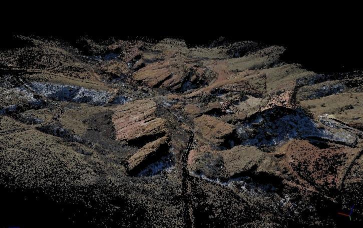
10 West Fork Lead & Zinc Mine (Sinkholes) Missouri DJI Inspire sinkholes Orthophotography Elevation Slope Aspect Flying at 325 feet (100 m) Above Ground Level - 2 cm GSD - 2 cm horizontal accuracy and 4 cm vertical 10


11 Debeque Landslide Debeque, Colorado Temporal series of Landslide models monitoring geomorphic processes. June 2013 October


12 Debeque Landslide Debeque, Colorado Green indicates possible movement over time 12 Point cloud comparison and calculations (using Cloud Compare)


13 Lake Havasu, Arizona WorldView 2 Multispectral (pan sharpened) UAS Canon s100 (modified blue filter) 13


14 Theodore Roosevelt National Monument North Dakota 14


15 Micro UAS 3DR Solo 15 Image courtesy 3DR
16 Applied UAS Projects Topography and Remote Sensing Monitoring Snow Depth and SWE Hayden Pass Burn Scar and Flood Alert Network


17 Rocky Mountain Snowpack Depth Noisy Basin Galena Summit Loch Vale Meadow


18 G.A. Sexstone, D.W. Clow, C.A. Penn Project beginning in FY 16 Installed three meteorological stations in headwaters Snowpack modeling and measurements to evaluate water resources forecasting


19 Estimate water volume by co-collecting snow depth measurements and computing SWE UAS equipped with laser altimeter, pulsed radar, data logger Linked to RTK GPS ground station Leverage existing USGS reference watershed USGS Halfmoon Creek near Malta, CO
20 Applied UAS Projects Topography and Remote Sensing Monitoring Snow Depth and SWE Hayden Pass Burn Scar and Flood Alert Network


21 Theodore Roosevelt National Monument North Dakota 21

22 Hayden Pass Burn Scar Freemont County, Colorado 22
23 Location Waldo Canyon Wildfire, Colorado (2012) Approximately 4 miles northwest of Colorado Springs, Colorado 2 fatalities 346 homes destroyed 28.5 square miles burned Waldo Canyon Basin, Pike National Forest Flash floods in July and August 2013 with 1 fatality Drainage Area: 1.76 square miles Mean Basin Elevation: 7,990 feet Mean Basin Slope: 45.4% Basin outlet located at US Highway 24

 Backwater Populated and frequently flooded areas 3621 3619 3620 3617 3618 3614 3616 3615 3611")
24 Gage Siting At-risk basins such as wildfire-burn scars Network design is transferrable Radar siting based on hydrology and basin characteristics Proximity to roadways and vital infrastructure Downstream from: Confluence points Land type dominated by rapid runoff Engineered structures, drainage, sewers Upstream from: Contractions (bridge openings or culverts) Backwater Populated and frequently flooded areas

25 Gage Siting Basin Delineation 4 Rapid Deployment Gages Located at: 1. 41% 2. 57% 3. 72% 4. 81% of the cumulative drainage area in the basin

26 Siting Basin Delineation

27 Equipment Typical Install 1. Non-contact velocity and stage radars 2. Data loggers and transmitters 3. Batteries with solar panel 4. Cable stay with Hilti bolt 5. Pelican case used as gage house


28 stage radar velocity radar Non-contact stage and velocity radar Sommer RQ-30 Measures continuous velocity and stage of flood waves
 modem Decisions regarding a Plan of Action will be made by Colorado Department of Transportation based on data")
29 Data CDOT to receive near realtime transmits when stage or velocity alarms are tripped SMS texts and with latency of less than 30 seconds Alarms can be reconfigured remotely through the 3G modem and copied to the Iridium Short Burst Data (SBD) modem Decisions regarding a Plan of Action will be made by Colorado Department of Transportation based on data received

30 Questions?
Unmanned Aircraft Systems (UAS) Activities in Earth Sciences
 Activities in Earth Sciences") Unmanned Aircraft Systems (UAS) Activities in Earth Sciences Bruce K. Quirk quirk@usgs.gov Department of the Interior U.S. Geological Survey June 22, 2015 Department of the Interior Bureau of Land Management
Unmanned Aircraft Systems (UAS) Activities in Earth Sciences Bruce K. Quirk quirk@usgs.gov Department of the Interior U.S. Geological Survey June 22, 2015 Department of the Interior Bureau of Land Management
Seeley Burn Scar SR-31, Region 4 UDOT Weather Response Summer 2013
 Seeley Burn Scar SR-31, Region 4 UDOT Weather Response Summer 2013 Seeley Burn Scar Information June 26 July 18, 2012 48,050 acres burned Lightning caused fire 8 miles of SR-31 impacted Huntington Creek
9. PROBABLE MAXIMUM PRECIPITATION AND PROBABLE MAXIMUM FLOOD
 9. PROBABLE MAXIMUM PRECIPITATION AND PROBABLE MAXIMUM FLOOD 9.1. Introduction Due to the size of Watana Dam and the economic importance of the Project to the Railbelt, the Probable Maximum Flood (PMF)
Water information system advances American River basin. Roger Bales, Martha Conklin, Steve Glaser, Bob Rice & collaborators UC: SNRI & CITRIS
 Water information system advances American River basin Roger Bales, Martha Conklin, Steve Glaser, Bob Rice & collaborators UC: SNRI & CITRIS Opportunities Unprecedented level of information from low-cost
USGS Hydrography Overview. May 9, 2018
 + 1 USGS Hydrography Overview May 9, 2018 + 2 The National Geospatial Program Provides the geospatial baseline of the Nation s topography, natural landscape and built environment through The National Map,
P R O U D LY C A N A D I A N
 P R O U D LY C A N A D I A N 1.855.423.3185 info@rmegeomatics.com AERIAL SURVEYING IMAGING TERRAIN ANALYSIS WHO WE ARE HSE & REGULATORY CLIENT INDUSTRIES RME Geomatics (formerly NGF Geomatics) was founded
Maximizing Geospatial Baseline Data for Optimizing Landsat Imageries: Assessing Climate Change Impacts
 Maximizing Geospatial Baseline Data for Optimizing Landsat Imageries: Assessing Climate Change Impacts B. Acharya, PhD, PLS Earth Mapping International B. Gyawali, PhD Kentucky State University D. Zourarakis,
Spatial Survey of Surface Soil Moisture in a Sub-alpine Watershed Colloquium Presentation, University of Denver, Department of Geography
 Thank you all for coming today. I will be talking about my thesis work concerning the spatial distribution of soil moisture in an alpine catchment. But first we need some background in soil moisture. Why
Areal Reduction Factors for the Colorado Front Range and Analysis of the September 2013 Colorado Storm
 Areal Reduction Factors for the Colorado Front Range and Analysis of the September 2013 Colorado Storm Doug Hultstrand, Bill Kappel, Geoff Muhlestein Applied Weather Associates, LLC - Monument, Colorado
City of Madison Flooding Event AUGUST 20 TH, 2018-PRESENT
 City of Madison Flooding Event AUGUST 20 TH, 2018-PRESENT Presentation Overview Review of Flash Flooding and Flooding from High Lake Levels (August 20 th -Present) Lake Level Information Damages FEMA How
Great Lakes Update. Geospatial Technologies for Great Lakes Water Management. Volume 149 October 4, US Army Corps of Engineers Detroit District
 Volume 149 October 4, 2002 US Army Corps of Engineers Detroit District Great Lakes Update Geospatial Technologies for Great Lakes Water Management The U.S. Army Corps of Engineers (USACE) serves an important
FEMA Hazards Loss Modeling Task Force (MOTF) Situation Report #14. Colorado Spring Flood Risk ***FINAL REPORT***
 Situation Report #14. Colorado Spring Flood Risk ***FINAL REPORT***") FEMA Hazards Loss Modeling Task Force (MOTF) Situation Report #14 Colorado Spring Flood Risk FEMA Modeling Task Force (MOTF) Denver Federal Center, Building 710A Denver, Colorado 80225 Email: FEMA-MOTF@fema.dhs.gov
FEMA Hazards Loss Modeling Task Force (MOTF) Situation Report #14 Colorado Spring Flood Risk FEMA Modeling Task Force (MOTF) Denver Federal Center, Building 710A Denver, Colorado 80225 Email: FEMA-MOTF@fema.dhs.gov
Section 4: Model Development and Application
 Section 4: Model Development and Application The hydrologic model for the Wissahickon Act 167 study was built using GIS layers of land use, hydrologic soil groups, terrain and orthophotography. Within
Geospatial Data, Services, and Products. National Surveying, mapping and geospatial conference
 Geospatial Data, Services, and Products Federal Programs -- USDA NRCS National Surveying, mapping and geospatial conference March 15, 2016 NRCS Applications using Geosaptial Products & Services Field
Areal Reduction Factors for the Colorado Front Range and Analysis of the September 2013 Colorado Storm
 Areal Reduction Factors for the Colorado Front Range and Analysis of the September 2013 Colorado Storm Doug Hultstrand, Bill Kappel, Geoff Muhlestein Applied Weather Associates, LLC - Monument, Colorado
Analysis of Road Sediment Accumulation to Monumental Creek using the GRAIP Method
 Analysis of Road Sediment Accumulation to Monumental Creek using the GRAIP Method Introduction (from http://www.neng.usu.edu/cee/faculty/dtarb/graip/#over): The Geomorphologic Road Analysis and Inventory
Manitoba s Elevation (LiDAR) & Imagery Datasets. Acquisition Plans & Opportunities for Collaboration
 & Imagery Datasets. Acquisition Plans & Opportunities for Collaboration") Manitoba s Elevation (LiDAR) & Imagery Datasets Acquisition Plans & Opportunities for Collaboration Manitoba Planning Conference May 2017 Presentation Outline Manitoba s Elevation (LiDAR) and Imagery Datasets
Manitoba s Elevation (LiDAR) & Imagery Datasets Acquisition Plans & Opportunities for Collaboration Manitoba Planning Conference May 2017 Presentation Outline Manitoba s Elevation (LiDAR) and Imagery Datasets
Chapter 6 Mapping and Online Tools
 Chapter 6 Mapping and Online Tools The stream site you monitor is just part of a much larger system. When analyzing stream health, it is important to take a holistic view by considering the entire watershed.
GIS and Remote Sensing
 Spring School Land use and the vulnerability of socio-ecosystems to climate change: remote sensing and modelling techniques GIS and Remote Sensing Katerina Tzavella Project Researcher PhD candidate Technology
Pierce Cedar Creek Institute GIS Development Final Report. Grand Valley State University
 Pierce Cedar Creek Institute GIS Development Final Report Grand Valley State University Major Goals of Project The two primary goals of the project were to provide Matt VanPortfliet, GVSU student, the
HKND Group Ltd Grand Canal Project
 HKND Group Ltd Grand Canal Project General Overview of Aerial Survey Project Managua, Nicaragua September 21 st 2015 Presented by: Jeff Elliott Managing Director CSA Global About CSA Global CSA Global
Water Yield and Precipitation Inputs for ECA-AB Analysis Grand Prairie Forest Management Area Weyerhaeuser Canada Ltd.
 Water Yield and Precipitation Inputs for ECA-AB Analysis Grand Prairie Forest Management Area Weyerhaeuser Canada Ltd. Prepared by Watertight Solutions August 30, 2007 Introduction The objective of this
Background. Points of Discussion. Hydrographic Models
 Airborne Laser Remote Sensing Technology: Providing Essential Hydrologic Information in the 21 st Century Warwick Hadley, Optech Incorporated Presented by: Warwick Hadley Sales Manager, Middle East and
Aerial Surveys in the Wenatchee River Basin Thermal Infrared and Color Videography
 Aerial Surveys in the Wenatchee River Basin Thermal Infrared and Color Videography December 12, 2002 Report to: Washington Department of Ecology P.O. Box 47600, Olympia, WA 98504-7600 by: Watershed Sciences,
Spatial Survey of Surface Soil Moisture in a Sub-alpine Watershed
 Spatial Survey of Surface Soil Moisture in a Sub-alpine Watershed Katherine E. Williams M.S. GISc Candidate Department of Geography, University of Denver October 7, 2010 Purpose 2 Introduction to Soil
UAV APPLICATIONS IN ENGINEERING. Presented By Wohnrade Civil Engineers, Inc.
 UAV APPLICATIONS IN ENGINEERING Presented By Wohnrade Civil Engineers, Inc. UAV BUSINESS STARTUP March 31, 2015 - Obtained DJI Inspire 1 Unmanned Aerial Vehicle (UAV) FAA requires Certificate of Authorization
PENNSYLVANIA DEPARTMENT OF TRANSPORTATION ENGINEERING DISTRICT 3-0
 PENNSYLVANIA DEPARTMENT OF TRANSPORTATION ENGINEERING DISTRICT 3-0 LYCOMING COUNTY S.R.15, SECTION C41 FINAL HYDROLOGIC AND HYDRAULIC REPORT STEAM VALLEY RUN STREAM RELOCATION DATE: June, 2006 REVISED:
NAVAJO NATION PROFILE
 NAVAJO NATION PROFILE Largest land based area and federally recognized tribe in the United States Over 27,000 square miles (or 17.2 million acres with a population of over 300,000 people. Covers Arizona,
An Overview of Operations at the West Gulf River Forecast Center Gregory Waller Service Coordination Hydrologist NWS - West Gulf River Forecast Center
 National Weather Service West Gulf River Forecast Center An Overview of Operations at the West Gulf River Forecast Center Gregory Waller Service Coordination Hydrologist NWS - West Gulf River Forecast
TSEGI WASH 50% DESIGN REPORT
 TSEGI WASH 50% DESIGN REPORT 2/28/2014 Daniel Larson, Leticia Delgado, Jessica Carnes I Table of Contents Acknowledgements... IV 1.0 Project Description... 1 1.1 Purpose... 1 Figure 1. Erosion of a Headcut...
Maximizing Geospatial Baseline Data for Optimizing Landsat Imageries: Assessing Climate Change Impacts
 Maximizing Geospatial Baseline Data for Optimizing Landsat Imageries: Assessing Climate Change Impacts B. Acharya, PhD, PLS Earth Mapping International B. Gyawali, PhD Kentucky State University D. Zourarakis,
Natural Variability in Annual Maximum Water Level and Outflow of Yellowstone Lake
 Natural Variability in Annual Maximum Water Level and Outflow of Yellowstone Lake Phillip E. Farnes Abstract The water level in Yellowstone Lake varies each year in response to differences in the winter
Issue 44: Phase II & III H&H Issues Date: 07/03/2006 Page 1
 Background Phase I of the NCFMP studies have primarily focused on the coastal plain and sandhills physiographic regions in of the State. Phase II and III study areas will focus on the piedmont, foothills,
WWA Summer Tour. Tuesday, June 20, Lander, Wyoming. Contents. Final Water Forum for Snowcover & Stream flow Generation
 Issue Sixty Five, Volume Two 2017 WWA Officers WWA Summer Tour Tuesday, June 20, 2017 Lander, Wyoming Tour highlights include: Worthen Meadows. Sinks Canyon, Popo Agie River Restoration project, Popo Agie
Structure from Motion Photogrammetry for 3D Reconstruction of Crater Glacier on Mount St. Helens, Washington, USA
 Julian Cross GEOG 593 Department of Geography Portland State University 12/5/16 Structure from Motion Photogrammetry for 3D Reconstruction of Crater Glacier on Mount St. Helens, Washington, USA Abstract:
NATURAL FORCE THREATS, MONITORING AND RESEARCH NEEDS
 NATURAL FORCE THREATS, MONITORING AND RESEARCH NEEDS 1 Southern California Thomas Fire and Montecito Debris Flows 2 Timeline/Description of Conditions Between December 4, 2017 and January 12, 2018, over
What s New in Topographic Information - USGS National Map
 + What s New in Topographic Information - USGS National Map SARGIS Workshop November 14, 2016 Rob Dollison, 703-648-5724 rdollison@usgs.gov + USGS 2 National Geospatial Program The National Geospatial
Airborne laser altimeter applications to water management
 Remote Sensing and Geographic Information Systems for Design and Operation of Water Resources 721 Systems (Proceedings of Rabal Symposium S3, April 1997). IAHS Publ. no. 242, 1997 Airborne laser altimeter
THE NEED FOR AN ADDITIONAL SPILLWAY AT THE SANFORD DAM BOILING SPRING LAKES, NC. Presentation for The Brunswick County Commissioners April 20, 2015
 THE NEED FOR AN ADDITIONAL SPILLWAY AT THE SANFORD DAM BOILING SPRING LAKES, NC Presentation for The Brunswick County Commissioners April 20, 2015 The Sanford Dam Earth Dam constructed in 1961 Drainage
LOMR SUBMITTAL LOWER NEHALEM RIVER TILLAMOOK COUNTY, OREGON
 LOMR SUBMITTAL LOWER NEHALEM RIVER TILLAMOOK COUNTY, OREGON Prepared for: TILLAMOOK COUNTY DEPARTMENT OF COMMUNITY DEVELOPMENT 1510-B THIRD STREET TILLAMOOK, OR 97141 Prepared by: 10300 SW GREENBURG ROAD,
Novel Snotel Data Uses: Detecting Change in Snowpack Development Controls, and Remote Basin Snow Depth Modeling
 Novel Snotel Data Uses: Detecting Change in Snowpack Development Controls, and Remote Basin Snow Depth Modeling OVERVIEW Mark Losleben and Tyler Erickson INSTAAR, University of Colorado Mountain Research
Lake Tahoe Watershed Model. Lessons Learned through the Model Development Process
 Lake Tahoe Watershed Model Lessons Learned through the Model Development Process Presentation Outline Discussion of Project Objectives Model Configuration/Special Considerations Data and Research Integration
Rocky Mountain Field Institute 2015 Annual Report Waldo Canyon Fire Restoration December 17, 2015
 December 17, 2015 815 South 25 th St, Suite 101 Colorado Springs, CO 80904 www.rmfi.org Dedicated to the conservation and stewardship of public lands in the Pikes Peak Region 2 Background In the summer
Study 16.5 Probable Maximum Flood (PMF)
") Initial Study Report Meeting Study 16.5 Probable Maximum Flood (PMF) October 22, 2014 Prepared by 10/22/2014 1 Study 16.5 Objectives Develop a site-specific PMP to be used for the derivation of the PMF
Initial Study Report Meeting Study 16.5 Probable Maximum Flood (PMF) October 22, 2014 Prepared by 10/22/2014 1 Study 16.5 Objectives Develop a site-specific PMP to be used for the derivation of the PMF
Watershed concepts for community environmental planning
 Purpose and Objectives Watershed concepts for community environmental planning Dale Bruns, Wilkes University USDA Rural GIS Consortium May 2007 Provide background on basic concepts in watershed, stream,
Waterborne Environmental, Inc., Leesburg, VA, USA 2. Syngenta Crop Protection, LLC, North America 3. Syngenta Crop Protection, Int.
 Application of High Resolution Elevation Data (LiDAR) to Assess Natural and Anthropogenic Agricultural Features Affecting the Transport of Pesticides at Multiple Spatial Scales Josh Amos 1, Chris Holmes
A SIMPLE GIS METHOD FOR OBTAINING FLOODED AREAS
 A SIMPLE GIS METHOD FOR OBTAINING FLOODED AREAS ROMAN P., I. 1, OROS C., R. 2 ABSTRACT. A simple GIS method for obtaining flooded areas. This paper presents a method for obtaining flooded areas near to
APPENDIX E. GEOMORPHOLOGICAL MONTORING REPORT Prepared by Steve Vrooman, Keystone Restoration Ecology September 2013
 APPENDIX E GEOMORPHOLOGICAL MONTORING REPORT Prepared by Steve Vrooman, Keystone Restoration Ecology September 2 Introduction Keystone Restoration Ecology (KRE) conducted geomorphological monitoring in
08/01/2012. LiDAR. LiDAR Benefits. LiDAR-BASED DELINEATION OF WETLAND BORDERS. CCFFR-2012 Society for Canadian Limnologists:
 LiDAR CCFFR-2012 Society for Canadian Limnologists: Science for Wetland Policy and Management LiDAR-BASED DELINEATION OF WETLAND BORDERS Distance from laser to ground and back again: Determined as laser-pulse
ABSTRACT INTRODUCTION
 INTER- AND INTRA-ANNUAL VARIABILITY IN SNOW ALBEDO, GRAIN SIZE, AND SNOW COVERED AREA FROM THE AIRBORNE SNOW OBSERVATORY DURING LOW SNOW YEARS (2013-2015), TUOLUMNE RIVER BASIN, CA S. McKenzie Skiles 1,
NORTHERN CHILE WINTER CLOUD SEEDING FEASIBILITY/DESIGN STUDY DON A. GRIFFITH NORTH AMERICAN WEATHER CONSULTANTS (NAWC) SANDY, UTAH
 SANDY, UTAH") NORTHERN CHILE WINTER CLOUD SEEDING FEASIBILITY/DESIGN STUDY DON A. GRIFFITH NORTH AMERICAN WEATHER CONSULTANTS (NAWC) SANDY, UTAH WMA SEMI-ANNUAL CONFERENCE SEPTEMBER 25-27, 2013 SANTIAGO, CHILE INTRODUCTION
NORTHERN CHILE WINTER CLOUD SEEDING FEASIBILITY/DESIGN STUDY DON A. GRIFFITH NORTH AMERICAN WEATHER CONSULTANTS (NAWC) SANDY, UTAH WMA SEMI-ANNUAL CONFERENCE SEPTEMBER 25-27, 2013 SANTIAGO, CHILE INTRODUCTION
5/4/2017 Fountain Creek. Gage Analysis. Homework 6. Clifton, Cundiff, Pour, Queen, and Zey CIVE 717
 5/4/2017 Fountain Creek Gage Analysis Homework 6 Clifton, Cundiff, Pour, Queen, and Zey CIVE 717 Introduction: The CIVE 717 class members, Nate Clifton, Susan Cundiff, Ali Reza Nowrooz Pour, Robbie Queen
USING 3D GIS TO ASSESS ENVIRONMENTAL FLOOD HAZARDS IN MINA
 King Fahd University of Petroleum & Minerals College of Environmental Design Geographical Information system USING 3D GIS TO ASSESS ENVIRONMENTAL FLOOD HAZARDS IN MINA Prepared by : Ali AL-Zahrani OUTLINE
Using MODIS imagery to validate the spatial representation of snow cover extent obtained from SWAT in a data-scarce Chilean Andean watershed
 Using MODIS imagery to validate the spatial representation of snow cover extent obtained from SWAT in a data-scarce Chilean Andean watershed Alejandra Stehr 1, Oscar Link 2, Mauricio Aguayo 1 1 Centro
Merced Irrigation District Hydrologic and Hydraulic Operations (MIDH2O) Model
 Model") Merced Irrigation District Hydrologic and Hydraulic Operations (MIDH2O) Model September 05, 2018 Marco Bell, Merced Irrigation District Bibek Joshi, Dewberry Objective Introduce HEC-RTS Benefits of MIDH2O
Merced Irrigation District Hydrologic and Hydraulic Operations (MIDH2O) Model September 05, 2018 Marco Bell, Merced Irrigation District Bibek Joshi, Dewberry Objective Introduce HEC-RTS Benefits of MIDH2O
Investigating the influences of climate on the high elevation snowpack hydrology in the upper Colorado region.
 University of Louisville ThinkIR: The University of Louisville's Institutional Repository Electronic Theses and Dissertations 5-2016 Investigating the influences of climate on the high elevation snowpack
GLACIER VARIABILITY IN WYOMING'S WIND RIVER & TETON RANGES
 GLACIER VARIABILITY IN WYOMING'S WIND RIVER & TETON RANGES Derrick Thompson, Jeb Bell, Jake Edmunds, Glen Tootle & Greg Kerr University of Wyoming Department of Civil Engineering OUTLINE Background Research
Fugro Geospatial: Turning Spatial Data into Knowledge
 Fugro Geospatial: Turning Spatial Data into Knowledge 2016 Fugro Geospatial, GIS and Consultants Locations Variety of Collection Platforms Traditional Mapping Traditional Mapping Imagery Photogrammetric
Each basin is surrounded & defined by a drainage divide (high point from which water flows away) Channel initiation
 Channel initiation") DRAINAGE BASINS A drainage basin or watershed is defined from a downstream point, working upstream, to include all of the hillslope & channel areas which drain to that point Each basin is surrounded &
DRAINAGE BASINS A drainage basin or watershed is defined from a downstream point, working upstream, to include all of the hillslope & channel areas which drain to that point Each basin is surrounded &
Tracy Fuller U. S. Geological Survey. February 24, 2016
 U. S. Geological Survey Arctic Elevation Data Involvement Statewide Alaska IfSAR Radar Collection Program Pan-Arctic Digital Elevation Map International Coordination Tracy Fuller U. S. Geological Survey
Storm Report: January 27, 2008 Maricopa County, AZ
 Storm Report: January 27, 2008 Maricopa County, AZ Engineering Division, Flood Warning Branch TABLE OF CONTENTS Meteorology...2 Precipitation...4 Runoff...9 ALERT System Alarms...12 TABLES Table 1 Summary
REMOTE SENSING AND GEOSPATIAL APPLICATIONS FOR WATERSHED DELINEATION
 REMOTE SENSING AND GEOSPATIAL APPLICATIONS FOR WATERSHED DELINEATION Gaurav Savant (gaurav@engr.msstate.edu) Research Assistant, Department of Civil Engineering, Lei Wang (lw4@ra.msstate.edu) Research
Flood Inundation Mapping
 KU GIS Day 2009 November 18, 2009 Flood Inundation Mapping Wendy L. Pearson NOAA s National Weather Service Central Region Headquarters Kansas City, Missouri Flood Inundation Mapping Objectives: Overview
Study 16.5 Probable Maximum Flood (PMF)
") Initial Study Report Meeting Study 16.5 Probable Maximum Flood (PMF) March 30, 2016 Prepared by 3/30/2016 1 Study 16.5 Status ISR documents (ISR Part D Overview): Status: Initial Study Report: Parts A,
Initial Study Report Meeting Study 16.5 Probable Maximum Flood (PMF) March 30, 2016 Prepared by 3/30/2016 1 Study 16.5 Status ISR documents (ISR Part D Overview): Status: Initial Study Report: Parts A,
Welcome to NetMap Portal Tutorial
 Welcome to NetMap Portal Tutorial Potential Applications What Can you do with the Portal? At least 25 things! 1) Locate the best potential fish habitats. 2) Identify biological hotspots. 3) Map floodplain
MISSOURI LiDAR Stakeholders Meeting
 MISSOURI LiDAR Stakeholders Meeting East-West Gateway June 18, 2010 Tim Haithcoat Missouri GIO Enhanced Elevation Data What s different about it? Business requirements are changing.fast New data collection
Surface & subsurface processes in mountain environments
 Surface & subsurface processes in mountain environments evapotranspiration snowmelt precipitation infiltration Roger Bales Martha Conklin Robert Rice Fengjing Liu Peter Kirchner runoff sublimation ground
District-Wide Approach to Water Resource Modeling
 District-Wide Approach to Water Resource Modeling Water Resources Conference October 16, 2012 Phil Belfiori, RCWD Chris Otterness, HEI Mike Lawrence, HEI Overview Rice Creek Watershed District Approximately
The Commercialization of High Resolution Data for Construction, Design and Planning. Nathan Fischer, PE
 The Commercialization of High Resolution Data for Construction, Design and Planning Nathan Fischer, PE 23 Offices across the nation. Woolpert Office Locations: Arlington, VA Atlanta, GA Charleston, SC
GEOMATICS. Shaping our world. A company of
 GEOMATICS Shaping our world A company of OUR EXPERTISE Geomatics Geomatics plays a mayor role in hydropower, land and water resources, urban development, transport & mobility, renewable energy, and infrastructure
2013 Snake River Fall Chinook Salmon Spawning Summary 2,667 2, ,391
 2013 Snake River Fall Chinook Salmon Spawning Summary by Bill Arnsberg, Nez Perce Tribe Phil Groves, Idaho Power Company Frank Mullins, U.S. Fish and Wildlife Service Debbie Milks, Washington Department
12/07/2017. Flash Flood Warning Service, an advanced approach towards flood resilient cities Floodplain Management Association Conference, Newcastle
 12/07/2017 Worldwide problem: Flash Floods Flash Floods are a Global Problem Flash Flood Warning Service, an advanced approach towards flood resilient cities Floodplain Management Association Conference,
UPPER COSUMNES RIVER FLOOD MAPPING
 UPPER COSUMNES RIVER FLOOD MAPPING DRAFT BASIC DATA NARRATIVE FLOOD INSURANCE STUDY SACRAMENTO COUTY, CALIFORNIA Community No. 060262 November 2008 Prepared By: CIVIL ENGINEERING SOLUTIONS, INC. 1325 Howe
A Near Real-time Flood Prediction using Hourly NEXRAD Rainfall for the State of Texas Bakkiyalakshmi Palanisamy
 A Near Real-time Flood Prediction using Hourly NEXRAD for the State of Texas Bakkiyalakshmi Palanisamy Introduction Radar derived precipitation data is becoming the driving force for hydrological modeling.
Gateway Trail Project
 Gateway Trail Project Debris Flow Hazard Assessment By: Juan de la Fuente April 30, 2010 Background- On April 22, 2010, the Shasta-Trinity National Forest (Mt. Shasta-McCloud Unit) requested a geologic
Airborne Geophysical Survey Report River Jordan Property
 Airborne Geophysical Survey Report River Jordan Property Prepared for: Inc. September 3, 2009 Precision GeoSurveys Inc. 520-355 Burrard Street, Vancouver, Canada V6C 2G8 www.precisiongeosurveys.com Table
Grant Opportunity Monitoring Bi-State Sage-grouse Populations in Nevada
 Grant Opportunity Monitoring Bi-State Sage-grouse Populations in Nevada Proposals are due no later than November 13, 2015. Grant proposal and any questions should be directed to: Shawn Espinosa @ sepsinosa@ndow.org.
High-Gradient Streams
 Chapter 4 Surface Processes Section 4 High-Gradient Streams What Do You See? Learning Outcomes In this section, you will Use models and real-time streamflow data to understand the characteristics of highgradient
Strategic planning of meteorological and snow monitoring stations Case of the Mayo watershed
 Strategic planning of meteorological and snow monitoring stations Case of the Mayo watershed Technical Note to : Yukon Energy Corporation #2 Miles Canyon Road Box 5920 Whitehorse YT Y1A 6S7 Alain N. Rousseau,
The Documentation of Extreme Hydrometeorlogical Events: Two Case Studies in Utah, Water Year 2005
 The Documentation of Extreme Hydrometeorlogical Events: Two Case Studies in Utah, Water Year 2005 Tim Bardsley1*, Mark Losleben2, Randy Julander1 1. USDA, NRCS, Snow Survey Program, Salt Lake City, Utah.
Existing NWS Flash Flood Guidance
 Introduction The Flash Flood Potential Index (FFPI) incorporates physiographic characteristics of an individual drainage basin to determine its hydrologic response. In flash flood situations, the hydrologic
Flash Flood Guidance System On-going Enhancements
 Flash Flood Guidance System On-going Enhancements Hydrologic Research Center, USA Technical Developer SAOFFG Steering Committee Meeting 1 10-12 July 2017 Jakarta, INDONESIA Theresa M. Modrick Hansen, PhD
Flash flood forecasting and warning infrastructures of National Meteorology and Hydrological Services of Cambodia
 Development and Implementation of the South East Asia Flash Flood Guidance System (SEAFFGS) Ha Noi, Viet Nam, 20-23 November 2017 Flash flood forecasting and warning infrastructures of National Meteorology
UNIT 1C. USING TOPOGRAPHIC MAPS WHERE IN THE WORLD... ARE YOU?
 UNIT 1C. USING TOPOGRAPHIC MAPS WHERE IN THE WORLD... ARE YOU? TIME 60-90 minutes LEVEL All BENCHMARKS Next Generation Science Standards MS-LS1.D Science & Engineering Practices Developing and Using Models
Lecture 3. Data Sources for GIS in Water Resources
 Lecture 3 Data Sources for GIS in Water Resources GIS in Water Resources Spring 2015 http://www.data.gov/ 1 USGS GIS data for Water http://water.usgs.gov/maps.html Watersheds of the US 2-digit water resource
13.2 USING VIRTUAL GLOBES TO IMPROVE SITUATIONAL AWARENESS IN THE NATIONAL WEATHER SERVICE
 13.2 USING VIRTUAL GLOBES TO IMPROVE SITUATIONAL AWARENESS IN THE NATIONAL WEATHER SERVICE Andy Foster* National Weather Service Springfield, Missouri* Keith Stellman National Weather Service Shreveport,
USGS Flood Inundation Mapping of the Suncook River in Chichester, Epsom, Pembroke and Allenstown, New Hampshire
 USGS Flood Inundation Mapping of the Suncook River in Chichester, Epsom, Pembroke and Allenstown, New Hampshire NH Water & Watershed Conference Robert Flynn, USGS NH-VT Water Science Center March 23, 2012
Using Remote Sensing to Analyze River Geomorphology
 Using Remote Sensing to Analyze River Geomorphology Seeing Water from Space Workshop August 11 th, 2015 George Allen geoallen@unc.edu Rivers impact: Geology Ecology Humans The atmosphere River Geomorphology
Lake Champlain Richelieu River Flood Inundation Mapping and Forecasting Tool
 Lake Champlain Richelieu River Flood Inundation Mapping and Forecasting Tool Rob Flynn USGS New England Water Science Center, NH/VT Office U.S. Department of the Interior U.S. Geological Survey Lake Champlain
EVALUATION AND MONITORING OF SNOWCOVER WATER RESOURCES IN CARPATHIAN BASINS USING GEOGRAPHIC INFORMATION AND SATELLITE DATA
 EVALUATION AND MONITORING OF SNOWCOVER WATER RESOURCES IN CARPATHIAN BASINS USING GEOGRAPHIC INFORMATION AND SATELLITE DATA Gheorghe Stancalie, Simona Catana, Anisoara Iordache National Institute of Meteorology
Chapter 10 - Sacramento Method Examples
 Chapter 10 Sacramento Method Examples Introduction Overview This chapter presents two example problems to demonstrate the use of the Sacramento method. These example problems use the SACPRE and HEC-1 computer
Michael Schaffner, Alexander Tardy, Jayme Laber, Carl Unkrich, and David Goodrich,
 Michael Schaffner, Alexander Tardy, Jayme Laber, Carl Unkrich, and David Goodrich, A collaborative effort between NWS Western Region Headquarters, NWS San Diego, NWS Oxnard, and the USDA-ARS Southwest
3D Elevation Program, Lidar in Missouri. West Central Regional Advanced LiDAR Workshop Ray Fox
 3D Elevation Program, Lidar in Missouri West Central Regional Advanced LiDAR Workshop Ray Fox National Enhanced Elevation Assessment (Dewberry, 2011) Sponsored by the National Digital Elevation Program
REDWOOD VALLEY SUBAREA
 Independent Science Review Panel Conceptual Model of Watershed Hydrology, Surface Water and Groundwater Interactions and Stream Ecology for the Russian River Watershed Appendices A-1 APPENDIX A A-2 REDWOOD
Governing Rules of Water Movement
 Governing Rules of Water Movement Like all physical processes, the flow of water always occurs across some form of energy gradient from high to low e.g., a topographic (slope) gradient from high to low
Why Geomorphology for Fish Passage
 Channel Morphology - Stream Crossing Interactions An Overview Michael Love Michael Love & Associates mlove@h2odesigns.com (707) 476-8938 Why Geomorphology for Fish Passage 1. Understand the Scale of the
Chapter 5 CALIBRATION AND VERIFICATION
 Chapter 5 CALIBRATION AND VERIFICATION This chapter contains the calibration procedure and data used for the LSC existing conditions model. The goal of the calibration effort was to develop a hydraulic
Using ArcGIS for Hydrology and Watershed Analysis:
 Using ArcGIS 10.2.2 for Hydrology and Watershed Analysis: A guide for running hydrologic analysis using elevation and a suite of ArcGIS tools Anna Nakae Feb. 10, 2015 Introduction Hydrology and watershed
Lesson 4b Remote Sensing and geospatial analysis to integrate observations over larger scales
 Lesson 4b Remote Sensing and geospatial analysis to integrate observations over larger scales We have discussed static sensors, human-based (participatory) sensing, and mobile sensing Remote sensing: Satellite
Yaneev Golombek, GISP. Merrick/McLaughlin. ESRI International User. July 9, Engineering Architecture Design-Build Surveying GeoSpatial Solutions
 Yaneev Golombek, GISP GIS July Presentation 9, 2013 for Merrick/McLaughlin Conference Water ESRI International User July 9, 2013 Engineering Architecture Design-Build Surveying GeoSpatial Solutions Purpose