NORTHERN CHILE WINTER CLOUD SEEDING FEASIBILITY/DESIGN STUDY DON A. GRIFFITH NORTH AMERICAN WEATHER CONSULTANTS (NAWC) SANDY, UTAH
|
|
|
- Geoffrey Porter
- 6 years ago
- Views:
Transcription
1 NORTHERN CHILE WINTER CLOUD SEEDING FEASIBILITY/DESIGN STUDY DON A. GRIFFITH NORTH AMERICAN WEATHER CONSULTANTS (NAWC) SANDY, UTAH WMA SEMI-ANNUAL CONFERENCE SEPTEMBER 25-27, 2013 SANTIAGO, CHILE
2 INTRODUCTION North American Weather Consultants (NAWC) was contacted by a mining interest in Chile asking about the feasibility of conducting a cloud seeding program in the upper Copiapo River Basin located in northern Chile. This initial contact lead to a site visit by Mr. Don Griffith (President of NAWC) to tour the potential target area and meet with local Chilean weather officials and water users. This site visit occurred in late May Based upon knowledge gained during this initial trip, NAWC submitted a proposal to conduct a detailed feasibility/design study. The mining company accepted this proposal and the work was begun in September A final report was submitted to the client in July Of Note; the American Society of Civil Engineers Guidelines for Cloud Seeding to Augment Precipitation (2006) indicates that a site specific feasibility study should be performed before a cloud seeding program is Implemented. If a program is not deemed to be feasible, then obviously a program should not be attempted.
3
4
5 GOAL OF STUDY The stated goal of the program is to increase winter snow pack in the target areas to provide additional spring and summer streamflow and recharge underground aquifers at a favorable benefit/cost ratio without the creation of any significant negative environmental impacts.
6 FEASIBILITY/DESIGN STUDY TASKS TO BE PERFORMED Review and Summary of Prior Studies and Research (Task I) Review and Analysis of Climatology of the Target Area (Task II) Development of a Preliminary Program Design (Task III) Establishment of Operational Criteria (Task IV) Development of Monitoring and Evaluation Methodology (Task V) Review of Environmental and Legal Aspects (Task VI) Development of Cost Estimates (Task VII) Final Report Preparation (Task VIII) Coordination Meetings and Presentations (Task IX)
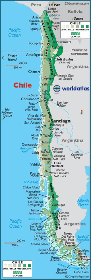
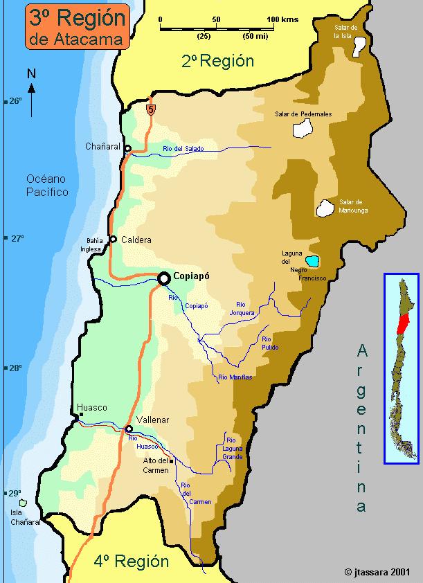
7 PROPOSED TARGET AREA NAWC proposed that the target area for the project include the upper portions ( > 3000 meters) of the three tributaries to the Copiapo River: 1) Rio Jorquera 2) Rio Pulido and 3) Rio Manfla plus the area north of the Rio Jorquera within the Copiapo River basin. Average crest height of the Andes in this area is > 4000 meters.

8 MAP OF PROPOSED TARGET AREA

9 SUPERCOOLED (< 0 C) CLOUD WATER DROPLETS: THE TARGET OF WINTER CLOUD SEEDING

10 IDEALIZED SCHEMATIC OF THE LOCATION OF A SUPERCOOLED LIQUID WATER ZONE IN RELATION TO A MOUNTAIN BARRIER UNDER WINTER STORM CONDITIONS
11 STORM PERIODS NAWC identified 36 storm periods that impacted the proposed target area during the winters of 2000 to Identification of these storm periods was based upon the observation of at least 5mm of precipitation at two lower elevation precipitation observation stations. NAWC acquired the rawinsonde (weather balloon) observations from Antofagasta and Santo Domingo for these storm periods. These two locations bracket the area of interest. Normally two soundings are made per day (00 and 12Z) but the Antofagasta site only conducts one sounding per day at 12Z. NAWC averaged some information of interest for the Antofagasta and Santo Domingo 12Z soundings to give a rough idea of the storm conditions in the proposed target area.

12 Courtesy of World Trade Press

13 PRECIPITATION AMOUNTS Site elevation 1950 m Site ~ 110 km south of target elevation ~ 4500m

14 PHOTO of SNOW DRIFTS FOLLOWING A MAY 6, 2007 WINTER STORM THAT IMPACTED THE PROPOSED TARGET AREA (Note Barren Landscape)
15 700 and 500 mb Storm Period Averages of Some Parameters of Interest Height Degrees C Wind Direction Wind Speed (kts) 700-mb average mb average Note: The average height of the -5 0 C level was 4.3 km (~ 14,000 feet MSL). 700 Mb Wind Rose during Storm Periods
16 ATMOSPHERIC STABILITY An analysis of the Antofagasta and Santo Domingo storm upper-air soundings indicated there were frequent atmospheric stability layers or inversions below the 500mb level. For Santo Domingo, there were 27 out of 34 cases with stability layers or inversions below the average height of the 5 0 C. Similar numbers for Antofagasta were 28 out of 34 cases. The presence of atmospheric stability layers below the height of the 5 0 C means that it is unlikely that silver iodide released from ground generators would ever reach the silver iodide effective level in a significant number of the storm periods. Consequentially, the usefulness of ground based generators located below the average height of the 5 0 C level (4.3km) would be questionable. The installation of remotely controlled ground based generators near this elevation could potentially be considered although correct targeting of the effects of seeding might be difficult considering the mean wind directions during storms (northwest) versus the availability of ground sites at this elevation located northwest of the target area. It is NAWC s impression such regions would be rugged, remote areas.

17 EXAMPLE OF A MANUALLY OPERATED SILVER IODIDE GENERATOR

18 EXAMPLE OF A REMOTELY OPERATED SILVER IODIDE GENERATOR


19 EXAMPLES OF AIRBORNE SEEDING METHODS

20 AIRCRAFT EJECTABLE SILVER IODIDE FLARE RACK
21 POTENTIAL EFFECTS OF CLOUD SEEDING The Estimated Effects of Cloud Seeding on Precipitation in the Copiapo Drainage are Expected to fall within the 5 to 15% Range per the Weather Modification Association s Capability Statement. (September 2011)
22 CLOUD SEEDING PROGRAM EVALUATIONS NAWC considers the historical target/control technique to be the best choice in evaluations of non-randomized, operational wintertime cloud seeding projects if the goal of such an evaluation is to establish some quantitative estimate of the increase in precipitation, snowpack or streamflow due to seeding. The development of regression equations using the target/control technique a priori, i.e., before any seeding is conducted, offers a means of eliminating any question of bias on the part of those conducting the subsequent evaluations. This is a step that is encouraged by the Weather Modification Association; that is, procedures to be used in evaluations should be specified in advance.
23 r 2 Values from Correlations between Annual Water Year (May through April) Streamflow at the Rio En Las Lozas Gage (Huasco Drainage) Versus Six Different Gages along the Copiapo River, Copiapo Stations Water Year Correlation (r 2 ) Rio Jorquera En Vertedero 0.80 Rio Pulido En Vertedero 0.97 Rio Manflas En Vertedero 0.93 Rio Copiapo En Lautaro 0.73 Rio Copiapo En Pastillo 0.98 Rio Copiapo En La Puerta 0.86 Generally good correlations; regression equations should be useful in estimating natural streamflow to be compared to actual streamflow during seeded years to determine if there are any systematic differences. Assumes the Huasco Drainage is not seeded in years the Copiapo Drainage is Seeded.
24 KEY RECOMMENDED DESIGN COMPONENTS Winter Program: April 15 to September 15 Seeding Agent: Silver Iodide (AgI) Seeding Mode: Airborne Liquid AgI and Ejectable AgI Flare Seeding (Turbine Aircraft). 24/7 Operations (Need to Maximize Seeding during Limited Opportunities). Seeding Suspensions during Potential Flash Flood Events. Provision for a Program Dedicated 5 cm Weather Radar, Located Upwind of the Target Area, Equipped with Aircraft Tracking System. Field Office Established at Radar Site with Internet, Telephone and Radio Communications. Program On Site Personnel: Experienced Cloud Seeding Meteorologist, One or Two Experienced Pilots, Part Time Technician. Program Evaluation Annual Final Report
25 ESTIMATED COSTS Preliminary cost estimates (in U.S. Dollars) were prepared for two winter seasons of cloud seeding based upon the recommended design provided in the report. Cost estimates were provided for a five-month operational period (April 15 through September 15). Costs estimates included reimbursable expenses of seeding (e.g., seeding materials and flight hours). Assumptions: lease of turbine engine aircraft equipped with acetone/silver iodide generators and ejectable flare rack for 5 months including 50 hours of seeding time, one aircraft pilot, base of operations established at a suitable airport near target area, project meteorologist stationed at an operations base (seeding decisions will be made from this location), one technician, one project dedicated 5cm weather radar. The weather radar, which would be a used version, would be purchased and installed before the beginning of the first operational season. The estimated one time charge to purchase and install this radar was $150,000. The cost estimate for the first season s fivemonth program was $472,500.
26 ESTIMATED INCREASES IN AVERAGE WATER YEAR STREAMFLOW AND ASSOCIATED COSTS Based upon the water years of 1974 to 2006, the estimated increase in the average annual flow at the La Puerta Gage on the Copiapo River due to the cloud seeding program, assuming a 10% increase due to seeding, would be m 3 /sec. This value would result in ~ 8,010,000 m 3 per water year. Similar calculations for the maximum and minimum values were ~33,901,000 and 2,428,000 m 3 per water year, respectively. Estimated Cost (U.S. Dollars) of Producing Additional Streamflow on the Copiapo River at La Puerta Copiapo River Estimated La Puerta m 3 Cost (U.S. Dollars) Minimum 2,228,272 $2.17 Average 8,010,144 $0.06 Maximum 33,901,200* $0.01 Note: 8,010,144 cubic m = 6496 acre-feet. Therefore the cost per acre-foot ~ $72 US
27 SUMMARY It was concluded that this feasibility/design study determined that an effective winter cloud seeding program could be established and operated for the proposed target area.
28 QUESTIONS?
29 North American Weather Consultants 8180 S. Highland Dr. Suite B-2 Sandy, Utah
A LEVEL II WEATHER MODIFICATION FEASIBILITY STUDY FOR WINTER SNOWPACK AUGMENTATION IN THE SALT RIVER AND WYOMING RANGES IN WYOMING
 A LEVEL II WEATHER MODIFICATION FEASIBILITY STUDY FOR WINTER SNOWPACK AUGMENTATION IN THE SALT RIVER AND WYOMING RANGES IN WYOMING Don A. Griffith, Mark E. Solak and David P. Yorty North American Weather
FEASIBILITY/DESIGN STUDY FOR A WINTER CLOUD SEEDING PROGRAM FOR THE ABAJO AND LA SAL MOUNTAIN RANGES, UTAH
 FEASIBILITY/DESIGN STUDY FOR A WINTER CLOUD SEEDING PROGRAM FOR THE ABAJO AND LA SAL MOUNTAIN RANGES, UTAH Don A. Griffith, David P. Yorty, Todd R. Flanagan and Stephanie D. Beall North American Weather
A Cloud Seeding Program to Enhance Hydroelectric Power Production from the El Cajon Drainage, Honduras
 A Cloud Program to Enhance Hydroelectric Power Production from the El Cajon Drainage, Honduras by Don A. Griffith, Mark E. Solak TRC North American Weather Consultants Salt Lake City, Utah, U.S.A. and
A BRIEF HISTORY OF EVALUATIONS PERFORMED ON THE OPERATIONAL KINGS RIVER WINTER OROGRAPHIC CLOUD SEEDING PROGRAM. Don A. Griffith and David P.
 AUGUST 2014 GRIFFITH ET AL. 29 A BRIEF HISTORY OF EVALUATIONS PERFORMED ON THE OPERATIONAL KINGS RIVER WINTER OROGRAPHIC CLOUD SEEDING PROGRAM Don A. Griffith and David P. Yorty North American Weather
4.1 THE SANTA BARBARA CLOUD SEEDING PROJECT IN COASTAL SOUTHERN CALIFORNIA, OPERATIONS AND RESEARCH SPANNING MORE THAN 50 YEARS
 4.1 THE SANTA BARBARA CLOUD SEEDING PROJECT IN COASTAL SOUTHERN CALIFORNIA, OPERATIONS AND RESEARCH SPANNING MORE THAN 50 YEARS Don A. Griffith * and Mark E. Solak North American Weather Consultants and
THE SANTA BARBARA CLOUD SEEDING PROJECT IN COASTAL SOUTHERN CALIFORNIA, SUMMARY OF RESULTS AND THEIR IMPLICATIONS
 THE SANTA BARBARA CLOUD SEEDING PROJECT IN COASTAL SOUTHERN CALIFORNIA, SUMMARY OF RESULTS AND THEIR IMPLICATIONS Don A. Griffith and Mark E. Solak North American Weather Consultants Sandy, Utah and Robert
A WINTER OPERATIONAL CLOUD SEEDING PROGRAM: UPPER GUNNISON RIVER BASIN, COLORADO. Don A. Griffith*, David P. Yorty and Mark E.
 April 2011 Griffith et al. 29 A WINTER OPERATIONAL CLOUD SEEDING PROGRAM: UPPER GUNNISON RIVER BASIN, COLORADO Don A. Griffith*, David P. Yorty and Mark E. Solak North American Weather Consultants, Inc.
Feasibility/Design Study for a Winter Cloud Seeding Program in the Upper Cuyama River Drainage, California
 North American Weather Consultants, Inc. Feasibility/Design Study for a Winter Cloud Seeding Program in the Upper Cuyama River Drainage, California Prepared for Santa Barbara County Water Agency by Don
Weather Modification Activities in the Colorado River Basin. Mohammed Mahmoud
 Weather Modification Activities in the Colorado River Basin Mohammed Mahmoud Historical Information Authorized by 1968 Basin Project Act Substantially completed in 1993 Responsible for repaying reimbursable
Mountain Snowpacks, Climate Change and the Silver Solution
 Mountain Snowpacks, Climate Change and the Silver Solution Climate Change Seminar Series University of Nevada Las Vegas 11 July 2012 Arlen Huggins Desert Research Institute Reno, Nevada Climate, snow and
9. PROBABLE MAXIMUM PRECIPITATION AND PROBABLE MAXIMUM FLOOD
 9. PROBABLE MAXIMUM PRECIPITATION AND PROBABLE MAXIMUM FLOOD 9.1. Introduction Due to the size of Watana Dam and the economic importance of the Project to the Railbelt, the Probable Maximum Flood (PMF)
Idaho Power Company s Cloud Seeding Program May 6, 2016
 Idaho Power Company s Cloud Seeding Program May 6, 2016 Shaun Parkinson, PhD, P.E. Overview What is cloud seeding & how is it done Idaho Power s history with cloud seeding Idaho Power s cloud seeding projects
The History of Cloud Seeding in Arizona
 The History of Cloud Seeding in Arizona VIII Winter Watershed Conference Show Low, AZ January 29, 2015 James Walter Water Resource Operations Salt River Project Clouds - Cloud condensation nuclei (CCN)
LOW-LEVEL STABILITY DURING WINTER STORMS IN THE UINTA BASIN OF UTAH: POTENTIAL IMPACTS ON GROUND-BASED CLOUD SEEDING
 14 JOURNAL OF WEATHER MODIFICATION VOLUME 45 LOW-LEVEL STABILITY DURING WINTER STORMS IN THE UINTA BASIN OF UTAH: POTENTIAL IMPACTS ON GROUND-BASED CLOUD SEEDING David Yorty, Warren Weston, Mark Solak,
4.2 OBSERVATIONS OF RIME ICING IN THE WASATCH MOUNTAINS OF UTAH: IMPLICATIONS REGARDING WINTER SEASON CLOUD SEEDING
 4.2 OBSERVATIONS OF RIME ICING IN THE WASATCH MOUNTAINS OF UTAH: IMPLICATIONS REGARDING WINTER SEASON CLOUD SEEDING Mark E. Solak *, David P. Yorty and Don A. Griffith North American Weather Consultants
Arizona Cloud Seeding Efforts: A Salt River Project Perspective. James Walter SRP Surface Water Resources CPWAC/CPWP Joint Meeting March 30, 2018
 Arizona Cloud Seeding Efforts: A Salt River Project Perspective James Walter SRP Surface Water Resources Importance of Winter Precipitation Winter Cloud Seeding 101 Early Cloud Seeding Projects Questions
Analysis of the Mt. Crested Butte Ice Detector and Associated Measurements in Colorado during the Winter Season
 North American Weather Consultants, Inc. Analysis of the Mt. Crested Butte Ice Detector and Associated Measurements in Colorado during the 2015-2016 Winter Season Prepared for Colorado Water Conservation
OBSERVATIONS OF RIME ICING IN THE WASATCH MOUNTAINS OF UTAH: IMPLICATIONS FOR WINTER SEASON CLOUD SEEDING
 28 OBSERVATIONS OF RIME ICING IN THE WASATCH MOUNTAINS OF UTAH: IMPLICATIONS FOR WINTER SEASON CLOUD SEEDING Mark E. Solak, David P. Yorty and Don A. Griffith North American Weather Consultants Sandy,
SUMMARY OF A TRIAL WINTER FOG CLEARING PROGRAM MISSOULA INTERNATIONAL AIRPORT WINTER SEASON
 North American Weather Consultants, Inc. SUMMARY OF A TRIAL WINTER FOG CLEARING PROGRAM MISSOULA INTERNATIONAL AIRPORT 2006-2007 WINTER SEASON Prepared for Missoula International Airport by North American
AWRA 2010 SUMMER SPECIALTY CONFERENCE San Juan, Puerto Rico CLOUD SEEDING TECHNOLOGY, A FEASIBLE ALTERNATIVE WATER SOURCE FOR THE CARIBBEAN?
 AWRA 2010 SUMMER SPECIALTY CONFERENCE San Juan, Puerto Rico August 30 September 1, 2010 Copyright 2010 AWRA CLOUD SEEDING TECHNOLOGY, A FEASIBLE ALTERNATIVE WATER SOURCE FOR THE CARIBBEAN? Don A. Griffith*
WEATHER MODIFICATION ASSOCIATION ANNUAL MEETING APRIL 21-25, 2009 ANAHEIM, CALIFORNIA
 WEATHER MODIFICATION ASSOCIATION ANNUAL MEETING APRIL 21-25, 2009 ANAHEIM, CALIFORNIA WEATHER MODIFICATION ASSOCIATION ANNUAL MEETING ANAHEIM, CALIFORNIA 8:30-8:40 Opening Remarks WEDNESDAY, APRIL 22
Weather Modification Level III Feasibility Study Laramie Range Siting and Design
 Weather Modification Level III Feasibility Study Laramie Range Siting and Design Executive Summary Frank McDonough, John F. Mejia, Kacie N. Shourd, Rosemary W. Carroll, Alexandra D. Lutz, Jeff Dean, Jeese
INTRODUCTION. A central area of research and services of the Atmospheric Sciences
 ISWS 52 EVALUATION OF THE McLEAN COUNTY RAINFALL MODIFICATION J PROJECTS IN 1977 AND 1978 Loanc.l Stanley A. Changnon, Chin-Fei Hsu, and Neil G. Towery Illinois State Water Survey Urbana, Illinois 61801
An Evaluation of Seeding Effectiveness in the Central Colorado Mountains River Basins Weather Modification Program
 2016, UCAR. All rights reserved. An Evaluation of Seeding Effectiveness in the Central Colorado Mountains River Basins Weather Modification Program for Grand River Consulting Sponsors: Colorado Water Conservation
Preliminary Observations of Cloud and Precipitation Characteristics in the Brisbane, Australia Region
 Preliminary Observations of Cloud and Precipitation Characteristics in the Brisbane, Australia Region Sarah Tessendorf April 23, 2008 R. Bruintjes,, J. Wilson, R. Roberts, E. Brandes,, P. May, J. Peter,
Wyoming Water Development Commission 6920 Yellowtail Road Cheyenne, WY tel fax wwdc.state.wy.us
 Prepared by Weather Modification, Inc. 3802 20 th Street North Fargo, ND 58102 701.235.5500 tel 701.235.9717 fax www.weathermod.com for the Wyoming Water Development Commission 6920 Yellowtail Road Cheyenne,
Final Report. Submitted to. Mr. Mark Foree and Mr. Jeff Tissier Truckee Meadows Water Authority 1355 Capital Blvd Reno, NV 89502
 Final Report Cloud Seeding Project for Tahoe and Truckee Basins for WY2016 Submitted to Mr. Mark Foree and Mr. Jeff Tissier Truckee Meadows Water Authority 1355 Capital Blvd Reno, NV 89502 Mr. Jim Smitherman
Using PRISM Climate Grids and GIS for Extreme Precipitation Mapping
 Using PRISM Climate Grids and GIS for Extreme Precipitation Mapping George H. Taylor, State Climatologist Oregon Climate Service 316 Strand Ag Hall Oregon State University Corvallis OR 97331-2209 Tel:
Missouri River Basin Water Management
 Missouri River Basin Water Management US Army Corps of Engineers Missouri River Navigator s Meeting February 12, 2014 Bill Doan, P.E. Missouri River Basin Water Management US Army Corps of Engineers BUILDING
A Summary of Current Programs and Opportunities for Enhancements
 INVENTORY AND ASSESSMENT OF COLORADO WEATHER MODIFICATION PROGRAMS A Summary of Current Programs and Opportunities for Enhancements October 1, 2015 Prepared For: Prepared by: This page intended to be blank
DRI s Cloud Seeding Program: Tahoe-Truck Project Results for Water Year Jeff Tilley, Arlen Huggins, and Robert David
 DRI s Cloud Seeding Program: Tahoe-Truck Project Results for Water Year 2013 Jeff Tilley, Arlen Huggins, and Robert David WRWC Planning Commission November 6, 2013 WY2013 Results: Tahoe-Truckee Basin CA-NV
The following information is provided for your use in describing climate and water supply conditions in the West as of April 1, 2003.
 Natural Resources Conservation Service National Water and Climate Center 101 SW Main Street, Suite 1600 Portland, OR 97204-3224 Date: April 8, 2003 Subject: April 1, 2003 Western Snowpack Conditions and
Climate Variability. Eric Salathé. Climate Impacts Group & Department of Atmospheric Sciences University of Washington. Thanks to Nathan Mantua
 Climate Variability Eric Salathé Climate Impacts Group & Department of Atmospheric Sciences University of Washington Thanks to Nathan Mantua Northwest Climate: the mean Factors that influence local/regional
UPDATED PRELIMINARY FEASIBILITY STUDY AND COST ESTIMATES FOR A POSSIBLE WINTER CLOUD SEEDING PROGRAM IN THE HUMBOLDT RIVER BASIN, NEVADA
 North American Weather Consultants, Inc. UPDATED PRELIMINARY FEASIBILITY STUDY AND COST ESTIMATES FOR A POSSIBLE WINTER CLOUD SEEDING PROGRAM IN THE HUMBOLDT RIVER BASIN, NEVADA Prepared for Humboldt River
Weather Modification and its development in Xinjiang. Caixia Cui, Xinjiang Meteorological Bureau 12 December 2015
 Weather Modification and its development in Xinjiang Caixia Cui, Xinjiang Meteorological Bureau 12 December 2015 Outline Operational activities and research in weather modification Legislation and policies
A critical review of the design, execution and evaluation of cloud seeding experiments
 A critical review of the design, execution and evaluation of cloud seeding experiments Roelof T. Bruintjes WMA Meeting September 2013, Santiago Research Applications Program, National Center for Atmospheric
Great Lakes Update. Volume 193: 2015 January through June Summary. Vol. 193 Great Lakes Update August 2015
 Great Lakes Update Volume 193: 2015 January through June Summary The U.S. Army Corps of Engineers (USACE) monitors the water levels of each of the Great Lakes. This report provides a summary of the Great
WIND DATA REPORT FOR THE YAKUTAT JULY 2004 APRIL 2005
 WIND DATA REPORT FOR THE YAKUTAT JULY 2004 APRIL 2005 Prepared on July 12, 2005 For Bob Lynette 212 Jamestown Beach Lane Sequim WA 98382 By John Wade Wind Consultant LLC 2575 NE 32 nd Ave Portland OR 97212
Great Lakes Update. Volume 188: 2012 Annual Summary
 Great Lakes Update Volume 188: 2012 Annual Summary Background The U.S. Army Corps of Engineers (USACE) tracks the water levels of each of the Great Lakes. This report highlights hydrologic conditions of
PRELIMINARY DRAFT FOR DISCUSSION PURPOSES
 Memorandum To: David Thompson From: John Haapala CC: Dan McDonald Bob Montgomery Date: February 24, 2003 File #: 1003551 Re: Lake Wenatchee Historic Water Levels, Operation Model, and Flood Operation This
HyMet Company. Streamflow and Energy Generation Forecasting Model Columbia River Basin
 HyMet Company Streamflow and Energy Generation Forecasting Model Columbia River Basin HyMet Inc. Courthouse Square 19001 Vashon Hwy SW Suite 201 Vashon Island, WA 98070 Phone: 206-463-1610 Columbia River
An Introduction to Weather Modification in West Texas
 An Introduction to Weather Modification in West Texas JONATHAN A. JENNINGS West Texas Weather Modification Association, San Angelo, TX Sonora Water Conference, 18 April 2013 Sonora, Texas What to expect:
Operational Perspectives on Hydrologic Model Data Assimilation
 Operational Perspectives on Hydrologic Model Data Assimilation Rob Hartman Hydrologist in Charge NOAA / National Weather Service California-Nevada River Forecast Center Sacramento, CA USA Outline Operational
SEEDING EXPERIMENT IN MISSOURI
 THE EVALUATION OF RAINFALL RECORDS FROM A FIVE YEAR CLOUD SEEDING EXPERIMENT IN MISSOURI WAYNE L. DECKER and PAUL T. SCHICKEDANZ UNIVERSITY OF MISSOURI 1. Introduction During the five year period from
CASCADES ATMOSPHERIC WATER RESOURCES PROGRAM
 State of Washington DANIEL J. EVANS, Governor DEPARTMENT OF WATER RESOURCES H MAURICE AHLQUIST, DIRECTOR CASCADES ATMOSPHERIC WATER RESOURCES PROGRAM F. Y. 1969 ANNUAL REPORT September 1, 1969 Prepared
The Documentation of Extreme Hydrometeorlogical Events: Two Case Studies in Utah, Water Year 2005
 The Documentation of Extreme Hydrometeorlogical Events: Two Case Studies in Utah, Water Year 2005 Tim Bardsley1*, Mark Losleben2, Randy Julander1 1. USDA, NRCS, Snow Survey Program, Salt Lake City, Utah.
March 1, 2003 Western Snowpack Conditions and Water Supply Forecasts
 Natural Resources Conservation Service National Water and Climate Center 101 SW Main Street, Suite 1600 Portland, OR 97204-3224 Date: March 17, 2003 Subject: March 1, 2003 Western Snowpack Conditions and
INVISIBLE WATER COSTS
 Every Drop Every Counts... Drop Counts... INVISIBLE WATER COSTS Corn - 108.1 gallons per pound How much water it takes to produce... Apple - 18.5 gallons to grow Beef - 1,581 gallons per pound Oats - 122.7
NATIONAL WEATHER SERVICE
 January 2016 February 9, 2016 This was a dry month across the HSA despite one large and several smaller snowfalls. Most locations ended up 1-2 inches below normal for the month. The driest locations at
CW3E Atmospheric River Update Outlook Strong AR forecast to impact California this weekend - A strong AR with IVT as high as 1000 kg m -1 s -1 is
 CW3E Atmospheric River Update Outlook Strong AR forecast to impact California this weekend - A strong AR with IVT as high as 1000 kg m -1 s -1 is forecast make landfall over the West Coast this Weekend
Appendix D. Model Setup, Calibration, and Validation
 . Model Setup, Calibration, and Validation Lower Grand River Watershed TMDL January 1 1. Model Selection and Setup The Loading Simulation Program in C++ (LSPC) was selected to address the modeling needs
3.5 A CASE STUDY OF MESOSCALE AND PLUME DISPERSION MODELING FOR A FEBRUARY 2004 CLOUD SEEDING EVENT IN THE WALKER RIVER BASIN OF CALIFORNIA/NEVADA
 3.5 A CASE STUDY OF MESOSCALE AND PLUME DISPERSION MODELING FOR A FEBRUARY 2004 CLOUD SEEDING EVENT IN THE WALKER RIVER BASIN OF CALIFORNIA/NEVADA Arlen W. Huggins* Darko Koracin Domagoj Podnar Ming Xiao
Speakers: NWS Buffalo Dan Kelly and Sarah Jamison, NERFC Jeane Wallace. NWS Flood Services for the Black River Basin
 Speakers: NWS Buffalo Dan Kelly and Sarah Jamison, NERFC Jeane Wallace NWS Flood Services for the Black River Basin National Weather Service Who We Are The National Oceanic and Atmospheric Administration
Presented by Jerry A. Gomez, P.E. National Hydropower Association Northeast Regional Meeting - September 17, 2009
 Presented by Jerry A. Gomez, P.E. National Hydropower Association Northeast Regional Meeting - September 17, 2009 Defining Probable Maximum Precipitation (PMP) PMP is the theoretically greatest depth of
-Assessment of current water conditions. - Precipitation Forecast. - Recommendations for Drought Monitor
 April 27, 2010 -Assessment of current water conditions - Precipitation Forecast - Recommendations for Drought Monitor 7 Day Precipitation 19-25 April 2010 Month-to-Date Precipitation 1-25 April 2010
Illinois Drought Update, December 1, 2005 DROUGHT RESPONSE TASK FORCE Illinois State Water Survey, Department of Natural Resources
 Illinois Drought Update, December 1, 2005 DROUGHT RESPONSE TASK FORCE Illinois State Water Survey, Department of Natural Resources For more drought information please go to http://www.sws.uiuc.edu/. SUMMARY.
The hydrologic service area (HSA) for this office covers Central Kentucky and South Central Indiana.
 for this office covers Central Kentucky and South Central Indiana.") MONTH YEAR January 2011 February 15, 2011 X An X inside this box indicates that no flooding occurred within this hydrologic service area. January 2011 was drier than normal in all locations in the area.
MONTH YEAR January 2011 February 15, 2011 X An X inside this box indicates that no flooding occurred within this hydrologic service area. January 2011 was drier than normal in all locations in the area.
The hydrologic service area (HSA) for this office covers Central Kentucky and South Central Indiana.
 for this office covers Central Kentucky and South Central Indiana.") NWS Form E-5 (04-2006) NATIONAL OCEANIC AND ATMOSPHERIC ADMINISTRATION (PRES. BY NWS Instruction 10-924) NATIONAL WEATHER SERVICE MONTHLY REPORT OF HYDROLOGIC CONDITIONS HYDROLOGIC SERVICE AREA (HSA) Louisville
NWS Form E-5 (04-2006) NATIONAL OCEANIC AND ATMOSPHERIC ADMINISTRATION (PRES. BY NWS Instruction 10-924) NATIONAL WEATHER SERVICE MONTHLY REPORT OF HYDROLOGIC CONDITIONS HYDROLOGIC SERVICE AREA (HSA) Louisville
NIDIS Intermountain West Regional Drought Early Warning System February 7, 2017
 NIDIS Drought and Water Assessment NIDIS Intermountain West Regional Drought Early Warning System February 7, 2017 Precipitation The images above use daily precipitation statistics from NWS COOP, CoCoRaHS,
Hydrologic Forecast Centre Manitoba Infrastructure, Winnipeg, Manitoba. MARCH OUTLOOK REPORT FOR MANITOBA March 23, 2018
 Page 1 of 21 Hydrologic Forecast Centre Manitoba Infrastructure, Winnipeg, Manitoba MARCH OUTLOOK REPORT FOR MANITOBA March 23, 2018 Overview The March Outlook Report prepared by the Hydrologic Forecast
MET Lecture 20 Mountain Snowstorms (CH16)
") MET 4300 Lecture 20 Mountain Snowstorms (CH16) Learning Objectives Provide an overview of the importance and impacts of mountain snowstorms in the western US Describe how topography influence precipitation
MET 4300 Lecture 20 Mountain Snowstorms (CH16) Learning Objectives Provide an overview of the importance and impacts of mountain snowstorms in the western US Describe how topography influence precipitation
The hydrologic service area (HSA) for this office covers Central Kentucky and South Central Indiana.
 for this office covers Central Kentucky and South Central Indiana.") January 2012 February 13, 2012 An X inside this box indicates that no flooding occurred within this hydrologic service area. January 2012 continued the string of wet months this winter. Rainfall was generally
January 2012 February 13, 2012 An X inside this box indicates that no flooding occurred within this hydrologic service area. January 2012 continued the string of wet months this winter. Rainfall was generally
CLIMATE CHANGE ADAPTATION BY MEANS OF PUBLIC PRIVATE PARTNERSHIP TO ESTABLISH EARLY WARNING SYSTEM
 CLIMATE CHANGE ADAPTATION BY MEANS OF PUBLIC PRIVATE PARTNERSHIP TO ESTABLISH EARLY WARNING SYSTEM By: Dr Mamadou Lamine BAH, National Director Direction Nationale de la Meteorologie (DNM), Guinea President,
Weather and the Atmosphere. RAP Short Course
 Weather and the Atmosphere RAP Short Course Syllabus 1) Vertical structure and composition of the atmosphere, basic weather variables 2) Warming Earth and its atmosphere the diurnal and seasonal cycles
NIDIS Intermountain West Drought Early Warning System April 18, 2017
 1 of 11 4/18/2017 3:42 PM Precipitation NIDIS Intermountain West Drought Early Warning System April 18, 2017 The images above use daily precipitation statistics from NWS COOP, CoCoRaHS, and CoAgMet stations.
Hydrologic Forecast Centre Manitoba Infrastructure, Winnipeg, Manitoba. FEBRUARY OUTLOOK REPORT FOR MANITOBA February 23, 2018
 Page 1 of 17 Hydrologic Forecast Centre Manitoba Infrastructure, Winnipeg, Manitoba FEBRUARY OUTLOOK REPORT FOR MANITOBA February 23, 2018 Overview The February Outlook Report prepared by the Hydrologic
Lake Tahoe Watershed Model. Lessons Learned through the Model Development Process
 Lake Tahoe Watershed Model Lessons Learned through the Model Development Process Presentation Outline Discussion of Project Objectives Model Configuration/Special Considerations Data and Research Integration
Great Lakes Update. Volume 199: 2017 Annual Summary. Background
 Great Lakes Update Volume 199: 2017 Annual Summary Background The U.S. Army Corps of Engineers (USACE) tracks and forecasts the water levels of each of the Great Lakes. This report is primarily focused
Novel Snotel Data Uses: Detecting Change in Snowpack Development Controls, and Remote Basin Snow Depth Modeling
 Novel Snotel Data Uses: Detecting Change in Snowpack Development Controls, and Remote Basin Snow Depth Modeling OVERVIEW Mark Losleben and Tyler Erickson INSTAAR, University of Colorado Mountain Research
WEATHER MODIFICATION ARTIFICIAL RAIN MAKING AND CLOUD SEEDING. Research done in this field goes back to as far as the early 1940s when the US military
 WEATHER MODIFICATION ARTIFICIAL RAIN MAKING AND CLOUD SEEDING Weather modification refers to willful manipulation of the climate or local weather. Research done in this field goes back to as far as the
Oregon Water Conditions Report April 17, 2017
 Oregon Water Conditions Report April 17, 2017 Mountain snowpack continues to maintain significant levels for mid-april. By late March, statewide snowpack had declined to 118 percent of normal after starting
Research on Increased Winter Orographic Precipitation by Cloud Seeding (FY 1979) Development of Cloud Seedability Criteria
 Development of Cloud Seedability Criteria") Utah State University DigitalCommons@USU Reports Utah Water Research Laboratory January 1979 Research on Increased Winter Orographic Precipitation by Cloud Seeding (FY 1979) Development of Cloud Seedability
Utah State University DigitalCommons@USU Reports Utah Water Research Laboratory January 1979 Research on Increased Winter Orographic Precipitation by Cloud Seeding (FY 1979) Development of Cloud Seedability
4.5 THE SNOWY PRECIPITATION ENHANCEMENT RESEARCH PROJECT
 4.5 THE SNOWY PRECIPITATION ENHANCEMENT RESEARCH PROJECT Mark Heggli* 1, Barry Dunn 2, Arlen Huggins 3, John Denholm 2, Loredana Angri 2 and Trevor Luker 2 1 Innovative Hydrology, Auburn, California, United
Great Lakes Update. Volume 194: 2015 Annual Summary
 Great Lakes Update Volume 194: 2015 Annual Summary Background The U.S. Army Corps of Engineers (USACE) tracks and forecasts the water levels of each of the Great Lakes. This report summarizes the hydrologic
National Wildland Significant Fire Potential Outlook
 National Wildland Significant Fire Potential Outlook National Interagency Fire Center Predictive Services Issued: April 1, 2008 Next Issue: May 1, 2008 Wildland Fire Outlook April 2008 through July 2008
NIDIS Intermountain West Drought Early Warning System February 12, 2019
 NIDIS Intermountain West Drought Early Warning System February 12, 2019 Precipitation The images above use daily precipitation statistics from NWS COOP, CoCoRaHS, and CoAgMet stations. From top to bottom,
Wind River Indian Reservation and Surrounding Area Climate and Drought Summary
 Northern Arapaho Tribe Wind River Indian Reservation and Surrounding Area Climate and Drought Summary Spring Events & Summer Outlook 2015 Spring Was Warm And Very Wet Across The Region The spring season
The general procedure for estimating 24-hour PMP includes the following steps:
 14th Conference on Applied Climatology Abstract # 71520 Using PRISM Climate Grids and GIS for Extreme Precipitation Mapping George H. Taylor and Christopher Daly Oregon State University Corvallis Oregon
Robert Shedd Northeast River Forecast Center National Weather Service Taunton, Massachusetts, USA
 Robert Shedd Northeast River Forecast Center National Weather Service Taunton, Massachusetts, USA Outline River Forecast Centers FEWS Implementation Status Forcing Data Ensemble Forecasting The Northeast
Missouri River Basin Water Management Monthly Update
 Missouri River Basin Water Management Monthly Update Participating Agencies 255 255 255 237 237 237 0 0 0 217 217 217 163 163 163 200 200 200 131 132 122 239 65 53 80 119 27 National Oceanic and Atmospheric
Great Lakes Update. Volume 191: 2014 January through June Summary. Vol. 191 Great Lakes Update August 2014
 Great Lakes Update Volume 191: 2014 January through June Summary The U.S. Army Corps of Engineers (USACE) monitors the water levels of each of the Great Lakes. This report provides a summary of the Great
Folsom Dam Water Control Manual Update
 Folsom Dam Water Control Manual Update Public Workshop April 3, 2014 Location: Sterling Hotel Ballroom 1300 H Street, Sacramento US Army Corps of Engineers BUILDING STRONG WELCOME & INTRODUCTIONS 2 BUILDING
NEW SCHEME TO IMPROVE THE DETECTION OF RAINY CLOUDS IN PUERTO RICO
 NEW SCHEME TO IMPROVE THE DETECTION OF RAINY CLOUDS IN PUERTO RICO Joan Manuel Castro Sánchez Advisor Dr. Nazario Ramirez UPRM NOAA CREST PRYSIG 2016 October 7, 2016 Introduction A cloud rainfall event
Natural Variability in Annual Maximum Water Level and Outflow of Yellowstone Lake
 Natural Variability in Annual Maximum Water Level and Outflow of Yellowstone Lake Phillip E. Farnes Abstract The water level in Yellowstone Lake varies each year in response to differences in the winter
The Montague Doppler Radar, An Overview
 ISSUE PAPER SERIES The Montague Doppler Radar, An Overview June 2018 NEW YORK STATE TUG HILL COMMISSION DULLES STATE OFFICE BUILDING 317 WASHINGTON STREET WATERTOWN, NY 13601 (315) 785-2380 WWW.TUGHILL.ORG
REQUIREMENTS FOR WEATHER RADAR DATA. Review of the current and likely future hydrological requirements for Weather Radar data
 WORLD METEOROLOGICAL ORGANIZATION COMMISSION FOR BASIC SYSTEMS OPEN PROGRAMME AREA GROUP ON INTEGRATED OBSERVING SYSTEMS WORKSHOP ON RADAR DATA EXCHANGE EXETER, UK, 24-26 APRIL 2013 CBS/OPAG-IOS/WxR_EXCHANGE/2.3
DK DM M EMORANDUM D ECEMBER 28, 2018 SUBJECT:
 TO: CC: FROM: SUBJECT: BOARD OF DIRECTORS M EMORANDUM D ECEMBER 28, 2018 ANDY MUELLER, GENERAL MANAGER DAVE DK KANZER, P.E. & DON MEYER, P.E. DK DM COLORADO RIVER BASIN WATER SUPPLY CONDITIONS UPDATE AND
Application and verification of ECMWF products 2015
 Application and verification of ECMWF products 2015 Instituto Português do Mar e da Atmosfera, I.P. 1. Summary of major highlights At Instituto Português do Mar e da Atmosfera (IPMA) ECMWF products are
Potential impacts of aerosol and dust pollution acting as cloud nucleating aerosol on water resources in the Colorado River Basin
 Potential impacts of aerosol and dust pollution acting as cloud nucleating aerosol on water resources in the Colorado River Basin Vandana Jha, W. R. Cotton, and G. G. Carrio Colorado State University,
Measures Also Significant Factors of Flood Disaster Reduction
 Non-Structual Measures Also Significant Factors of Flood Disaster Reduction Babiaková Gabriela, Leškov ková Danica Slovak Hydrometeorological Institute, Bratislava Hydrological Forecasts and Warning Department
Community Collaborative RAin, Hail and Snow network. CoCoRaHS.
 Community Collaborative RAin, Hail and Snow network CoCoRaHS http://ks.cocorahs.org An observer s guide to measuring and reporting precipitation data! Equipment Each volunteer participating in CoCoRaHS
The current status, functions, challenges and needs of South Sudan Meteorological Department (SSMD)
") The current status, functions, challenges and needs of South Sudan Meteorological Department (SSMD) Presented: by Mojwok Ogawi Modo, South Sudan Meteorological Department. Background The present SSMD was
The current status, functions, challenges and needs of South Sudan Meteorological Department (SSMD) Presented: by Mojwok Ogawi Modo, South Sudan Meteorological Department. Background The present SSMD was
Wind River Indian Reservation and Surrounding Area Climate and Drought Summary
 Northern Arapaho Tribe Wind River Indian Reservation and Surrounding Area Climate and Drought Summary Summer Events & Fall Outlook 2015 Summer Was Near, Precipitation Was Highly Variable Across The Region
Seasonal Outlook through September 2007
 Seasonal Outlook through September 2007 Klaus Wolter (18apr07) University of Colorado, CIRES & NOAA-ESRL Climate Analysis Branch klaus.wolter@noaa.gov http://www.cdc.noaa.gov/people/klaus.wolter/swcasts/
Prepared for. Santa Barbara County Public Works Department Water Agency Division. Stephanie D. Beall, CO Don A. Griffith, CCM, CM, CO
 North American Weather Consultants, Inc. Summary of Operations for a Winter Cloud Seeding Program for the Huasna-Alamo Drainage in Northern Santa Barbara and Southern San Luis Obispo Counties Water Year
Weather and Climate of the Rogue Valley By Gregory V. Jones, Ph.D., Southern Oregon University
 Weather and Climate of the Rogue Valley By Gregory V. Jones, Ph.D., Southern Oregon University The Rogue Valley region is one of many intermountain valley areas along the west coast of the United States.
WEATHER FORECASTING Acquisition of Weather Information WFO Regions Weather Forecasting Tools Weather Forecasting Tools Weather Forecasting Methods
 1 2 3 4 5 6 7 8 WEATHER FORECASTING Chapter 13 Acquisition of Weather Information 10,000 land-based stations, hundreds of ships and buoys; four times a day, airports hourly Upper level: radiosonde, aircraft,
Webinar and Weekly Summary February 15th, 2011
 Webinar and Weekly Summary February 15th, 2011 -Assessment of current water conditions - Precipitation Forecast - Recommendations for Drought Monitor Upper Colorado Normal Precipitation Upper Colorado
Fort Lewis, Washington (47 05'N, 'W)
") Fort Lewis, Washington (47 05'N, 122 35'W) Full Year Climatology CONVENTIONS: The spelling of place names and geographical features are those used by the National Imagery and Mapping Agency (NIMA). All
Fort Lewis, Washington (47 05'N, 122 35'W) Full Year Climatology CONVENTIONS: The spelling of place names and geographical features are those used by the National Imagery and Mapping Agency (NIMA). All
Great Lakes Update. Great Lakes Winter and Spring Summary January June Vol. 187 Great Lakes Update August 2012
 Great Lakes Update Great Lakes Winter and Spring Summary January June 2012 The US Army Corps of Engineers (USACE) Detroit District monitors hydraulic and hydrologic conditions of the Great Lakes. This