HKND Group Ltd Grand Canal Project
|
|
|
- Donald York
- 6 years ago
- Views:
Transcription


1 HKND Group Ltd Grand Canal Project General Overview of Aerial Survey Project Managua, Nicaragua September 21 st 2015 Presented by: Jeff Elliott Managing Director CSA Global

2 About CSA Global CSA Global is a leading geological, data, mining and management consulting company which provides high quality solutions to our clients in the natural resources and extraction industries Our staff include geoscientists, engineers, project managers, data management professionals and technical personnel 30 Year History >100 Employees Global Experience Global Presence Full Project Capability Initial survey to production technical services Project reviews, program design & management Operational audits and improvement strategies Expert reporting to various international standards Mineral Resource and Ore Reserve estimation Concept to feasibility studies. Gap analysis, fatal flaw studies & due diligence Independent reports, valuations & specialist advice

3 Our Offices & Projects

4 Aerial Survey
5 Summary of Project Detailed topography, photography & geophysical survey of canal route corridor, lake edges & oceanic approaches Objective is to collect high-resolution survey data, aerial photography & airborne geophysics to map topography, surface infrastructure & vegetation, & interpret surface and sub-surface geology throughout the canal corridor alignment The output will provide & form baseline information to enable construction works to be accurately engineered, estimated, sequenced and executed, along with potential fine tuning of the canal route & capture a historical (pre-works) record of the project area Survey works will be reported in UTM coordinates Zone 16N with reference to the WGS84 geographic system, & suitable for use at 1:2000 scale

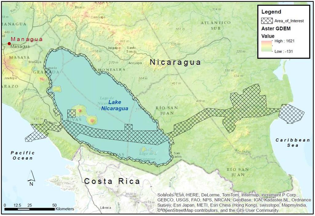
6 Project Map
7 Sub-Projects Areas Pacific - 2km dredge path in the Pacific Ocean approaches West Canal - Brito Port, Brito Lock, the Pan American Highway Bridge, Pacific Resort and Pacific FTZ Lake Nicaragua - canal path, dredge disposal area & proposed artificial islands Lake Perimeter - includes the Lake Resort on Isla de Omtepe & the lake perimeter surveys (topography & photography) East Canal - canal path across the Caribbean watershed & the proposed Lake Atlanta Caribbean 15km dredge path in the Caribbean Sea approaches & the proposed Aguila Port development
8 Scope Topography Topography, elevation contours & imagery of approaches, land, canopy and lake (~4500 km 2, ~18000 line km) High-resolution, airborne LiDAR (Laser Imaging Detection & Ranging) survey & mapping Accuracy to <0.2m nominal & contour 1m or better via RTK GPS ground points and PPP GPS processing Digital aerial photography & digital video as pre-works catalogue of canal alignment Digital terrain (DTM) & digital elevation models (DEM) for comparison & verification of existing survey mapping data Also for analysis of vegetation types & surface mapping e.g. infrastructure, dwellings or archaeology
9 Regional Topography
10 Scope Geology Undertake an initial desk-top review of publicly available geological data to allow refinement of survey if required Collect airborne magnetic & radiometric geophysical data (4000 km 2, ~34000 line km) Collate desk-top, geophysical & topo info into GIS database & generate geological interpretation of the canal route: o o o o o Map & interpret cover lithology, regolith & basement geology based on new geophysical data, LiDAR & aerial photography Identify & discuss structures (faults, fractures, etc.) & geohazards Assess material type & density (in terms of excavation properties) Identify areas of interest for construction materials e.g. suitable for armour material, aggregate or cement manufacture Comment on surface water & likely underground aquifers

11 Regional Geology Geology of Nicaragua, INETER, 2004


12 LiDAR - Process Pulses of light sent out, time until echo comes back is measured to accuracy of a few trillionth's of a second Distance to target can be calculated based on the speed of light Laser distance to ground GPS - aircraft position IMU - roll, pitch & heading Scanner pointing direction beneath aircraft
 & Bathymetric: Aquarius (green) Multi-haz echo sounder collects 300,000 points per second Opening")

13 LiDAR - Equipment Fixed-wing, Cessna 206, turbo-prop Dual Optech LiDAR systems employed; Topo: Gemini (infrared) & Bathymetric: Aquarius (green) Multi-haz echo sounder collects 300,000 points per second Opening lens of +/- 50, m survey width per line Average density of 4-12 points/m² Number of points depends on vegetation & reflectivity of surfaces Due to huge amount of data the digital products are presented as 1 km x 1 km tiles

14 LiDAR examples

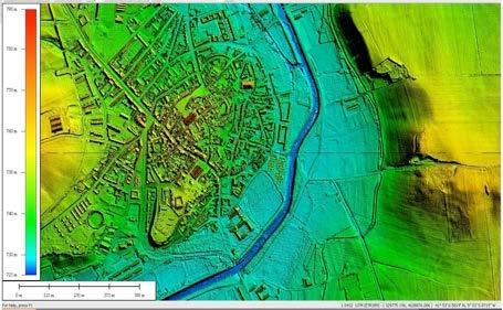
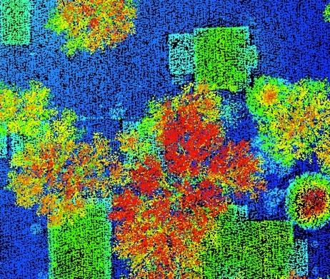
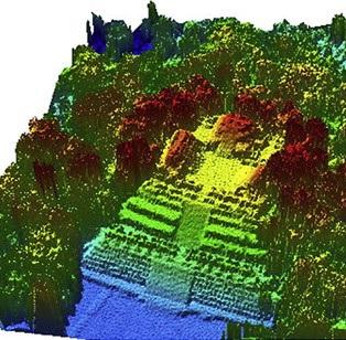

15 LiDAR examples
 will be used for photogrammetry with Resolution of 10-20 cm pixels Velocity of the camera is 30 seconds per take Photographs will be ortho-rectified by")
16 Aerial Photography Acquisition of digital colour photography is planned for end of wet season (October / November) when lighting is best to improve colour balance & minimise cloud shading A Nikon D810 industrial aerial digital camera (36MP) will be used for photogrammetry with Resolution of cm pixels Velocity of the camera is 30 seconds per take Photographs will be ortho-rectified by integrating with the LiDAR survey & control points The mosaiced photography will be draped on the DTM to create a 3D image of the route The geo-referenced (GeoTIF) imagery will be used to provide a digital video flythrough of the project area with input from HKND
 sampling rate, 0.")
 sampling rate in 256 channels KRA405B radar altimeter, 0.")

17 Geophysics - Equipment Fixed-wing, Piper Navajo PA twinengine aircraft with fixed stinger Caesium vapour magnetometer, 20 Hz (0.05 sec) sampling rate, nt res. RS-500 gamma ray spectrometer, 2Hz (0.5 sec) sampling rate in 256 channels KRA405B radar altimeter, 0.3m resolution, ± 5% accuracy at 500' to 2500 elevation Novatel 14 channel DGPS system, Thomson survey navigation and guidance system A base station magnetometer will be setup to monitor diurnal variations to correct the aeromagnetic data


18 Jeff Elliott Managing Director Jeff.Elliott@csaglobal.com
Ramani Geosystems. Putting Africa On The Map. Authorized Resellers
 Ramani Geosystems Putting Africa On The Map Authorized Resellers Ramani Profile Started in 1999 Aerial, Land Surveying & Mapping Solutions + 10 Countries in the region + 80 Staff working in projects Asset
Airborne Corridor-Mapping. Planning and documentation of company infrastructure: precise, rapid, and cost effective
 Airborne Corridor-Mapping Planning and documentation of company infrastructure: precise, rapid, and cost effective Technology Airborne Laser-Scanning, digital orthophotos and thermal imaging: one flight
P R O U D LY C A N A D I A N
 P R O U D LY C A N A D I A N 1.855.423.3185 info@rmegeomatics.com AERIAL SURVEYING IMAGING TERRAIN ANALYSIS WHO WE ARE HSE & REGULATORY CLIENT INDUSTRIES RME Geomatics (formerly NGF Geomatics) was founded
GEOMATICS. Shaping our world. A company of
 GEOMATICS Shaping our world A company of OUR EXPERTISE Geomatics Geomatics plays a mayor role in hydropower, land and water resources, urban development, transport & mobility, renewable energy, and infrastructure
ESRI GIS For Mining Seminar, 10 th August, 2016, Nairobi, Kenya. Spatial DATA Solutions for Mining
 ESRI GIS For Mining Seminar, 10 th August, 2016, Nairobi, Kenya Spatial DATA Solutions for Mining Spatial Data Solutions for Mining Spatial - Data that identifies the geographic location of features &
DMS-UAV Accuracy Assessment: AP20 with Nikon D800E
 DMS-UAV Accuracy Assessment: AP20 with Nikon D800E Joe Hutton, Greg Lipa, James Lutes, Omer Mian Applanix, William Chan - GeoPixel Air Introduction The Direct Mapping Solution for Unmanned Aerial Vehicles
SURVEYING Chapter 1 Introduction
 PHILADELPHIA UNIVERSITY Faculty of Engineering. Department of Civil Engineering. SURVEYING Chapter 1 Introduction Surveying : the art or science of measuring and representing natural and artificial features
indigeo Consultants Pvt Ltd Geophysical Surveys Geological Surveys GIS & Data Solutions Image Processing indigeo Company Profile, Page 1
 indigeo Consultants Pvt Ltd Geophysical Surveys Geological Surveys GIS & Data Solutions Image Processing MM Corner, 3 rd Floor #58, Banaswadi Main Road Bangalore 560033 INDIA Ph: +91 80 41638310 Mob: +91
Chapter 5 LiDAR Survey and Analysis in
 Chapter 5 LiDAR Survey and Analysis in 2010-2011 Christopher Fennell A surveyor s plat and town plan filed in 1836 set out an intended grid of blocks, lots, alleys, and streets for New Philadelphia. Geophysical,
Airborne Geophysical Survey Report River Jordan Property
 Airborne Geophysical Survey Report River Jordan Property Prepared for: Inc. September 3, 2009 Precision GeoSurveys Inc. 520-355 Burrard Street, Vancouver, Canada V6C 2G8 www.precisiongeosurveys.com Table
THE USE OF GEOMATICS IN CULTURAL HERITAGE AND ARCHAEOLOGY FOR VARIOUS PURPOSES
 THE USE OF GEOMATICS IN CULTURAL HERITAGE AND ARCHAEOLOGY FOR VARIOUS PURPOSES FEBRUARY 2013 AL BEIDA GEOPLAN CONTENT Company Profile Concept Objectives and Strategies Data Production Methods Data Samples
ASX Company Announcement
 ASX Company Announcement Yellow Rock Resources ACN: 116 221 740 35 Great Eastern Highway Rivervale WA 6103 Telephone: (08) 9361 5400 Facsimile: (08) 9361 5900 Email: info@aurium.com.au Companies Announcement
Hazard Mapping Along the Dead Sea Shoreline
 FIG Working Week in Marrakech, Morocco 18-22 May 2011 Hazard Mapping Along the Dead Sea Shoreline Rami Al-Ruzouq, Abdullah Al-Zuobi, AbdEl-Rahman Abueladas, Emad Akkawi Department of Surveying and Geomatics
ISO Swift Current LiDAR Project 2009 Data Product Specifications. Revision: A
 ISO 19131 Swift Current LiDAR Project 2009 Data Product Specifications Revision: A Data product specifications: Swift Current LiDAR Project 2009 - Table of Contents- 1. Overview... 4 1.1. Informal description...
Manitoba s Elevation (LiDAR) & Imagery Datasets. Acquisition Plans & Opportunities for Collaboration
 & Imagery Datasets. Acquisition Plans & Opportunities for Collaboration") Manitoba s Elevation (LiDAR) & Imagery Datasets Acquisition Plans & Opportunities for Collaboration Manitoba Planning Conference May 2017 Presentation Outline Manitoba s Elevation (LiDAR) and Imagery Datasets
Manitoba s Elevation (LiDAR) & Imagery Datasets Acquisition Plans & Opportunities for Collaboration Manitoba Planning Conference May 2017 Presentation Outline Manitoba s Elevation (LiDAR) and Imagery Datasets
Landslide Mapping and Hazard Analysis for a Natural Gas Pipeline Project
 CIVIL GOVERNMENT SERVICES MINING & METALS OIL, GAS & CHEMICALS POWER Albert Kottke, Mark Lee, & Matthew Waterman Landslide Mapping and Hazard Analysis for a Natural Gas Pipeline Project Technical Innovation
PROJECT FOR THE PRODUCTION OF 1/1000 SCALE BASE MAPS FROM COLOUR IMAGES USING DIGITAL CAMERAS IN BURSA METROPOLITAN AREA (BMA) IN TURKEY
 IN TURKEY") PROJECT FOR THE PRODUCTION OF 1/1000 SCALE BASE MAPS FROM COLOUR IMAGES USING DIGITAL CAMERAS IN BURSA METROPOLITAN AREA (BMA) IN TURKEY Şenol KUŞCU, M.Sait AYIK, Eray CAN, Hasan Yasar ARKAYIN, Turkey
PROJECT FOR THE PRODUCTION OF 1/1000 SCALE BASE MAPS FROM COLOUR IMAGES USING DIGITAL CAMERAS IN BURSA METROPOLITAN AREA (BMA) IN TURKEY Şenol KUŞCU, M.Sait AYIK, Eray CAN, Hasan Yasar ARKAYIN, Turkey
Does the SDCP need inputs from geology?
 The British Geological Survey s Experience and Expertise in Supporting Projects such as the Sirte Depression Connection Project David Ovadia Director of International Kingsley Dunham Centre Keyworth Nottingham
Papua New Guinea LiDAR Factsheet. Pacific-Australia Climate Change Science and Adaptation Planning. Vanimo. Bismark Sea. Wewak
 Pacific-Australia Climate Change Science and Adaptation Planning INDONESIA Vanimo Ninigo Group Wewak Madang Mount Hagen Kundiawa Goroka Mendi Daru AUSTRALIA Kerema Gulf of Papua Admiralty Islands Mussau
For personal use only
 27 September 2016 Sovereign Gold Company Limited ACN 145 184 667 Suite 7, 234 Churchill Avenue SUBIACO WA 6008 Tel: +61 8 6500 6872 Contact Rocco Tassone, Managing Director e: corporate@sovereigngold.com.au
A detailed description of the history, setup and performance of SGL s navigation and drape flying system is contained in reference [1].
![A detailed description of the history, setup and performance of SGL s navigation and drape flying system is contained in reference [1].](/thumbs/90/103916008.jpg "A detailed description of the history, setup and performance of SGL s navigation and drape flying system is contained in reference [1].") Pre-planned drape surfaces: a new survey planning tool Luise Sander* * Sander Geophysics Limited, 260 Hunt Club Road, Ottawa, Ontario, K1V 1C1 Originally presented at CSEG Forum: High Resolution Aeromagnetics
Pre-planned drape surfaces: a new survey planning tool Luise Sander* * Sander Geophysics Limited, 260 Hunt Club Road, Ottawa, Ontario, K1V 1C1 Originally presented at CSEG Forum: High Resolution Aeromagnetics
Geo-hazard Potential Mapping Using GIS and Artificial Intelligence
 Geo-hazard Potential Mapping Using GIS and Artificial Intelligence Theoretical Background and Uses Case from Namibia Andreas Knobloch 1, Dr Andreas Barth 1, Ellen Dickmayer 1, Israel Hasheela 2, Andreas
12/26/2012. Geographic Information Systems * * * * GIS (... yrezaei
 ( - Geographic Information Systems ( ( 1 2 3 Information System Data base DB IS IS DB (Knowledge ( ( (System (Information System - (Georefrence Analysis Data + Knowledge ======== Information 4 5 ( < 10%
Offshore Operations and Project Execution Geophysical Site Surveys
 Offshore Operations and Project Execution Geophysical Site Surveys Chris Almond Senior Geophysicist Fugro Survey Limited 22/04/2015 Presentation Summary: Office-based Personnel Project Awarded Pre Offshore
Supplement of Scenario-based numerical modelling and the palaeo-historic record of tsunamis in Wallis and Futuna, Southwest Pacific
 Supplement of Nat. Hazards Earth Syst. Sci., 15, 1763 1784, 2015 http://www.nat-hazards-earth-syst-sci.net/15/1763/2015/ doi:10.5194/nhess-15-1763-2015-supplement Author(s) 2015. CC Attribution 3.0 License.
Southwestern Ontario Orthophotography Project (SWOOP) 2015 Digital Elevation Model
 2015 Digital Elevation Model") Southwestern Ontario Orthophotography Project (SWOOP) 2015 Digital Elevation Model User Guide Provincial Mapping Unit Mapping and Information Resources Branch Corporate Management and Information Division
Southwestern Ontario Orthophotography Project (SWOOP) 2015 Digital Elevation Model User Guide Provincial Mapping Unit Mapping and Information Resources Branch Corporate Management and Information Division
DRAPE 2014 Digital Elevation Model
 DRAPE 2014 Digital Elevation Model User Guide Spatial Data Infrastructure Mapping and Information Resources Branch Corporate Management and Information Division Ministry of Natural Resources and Forestry
T: E:
 PAS 128 UTILITY DETECTION AND MAPPING TOPOGRAPHICAL SURVEYS UTILITY RECORD SEARCHES AND DESK TOP STUDY SURFACE WATER DRAINAGE SURVEYS GROUND CLEARANCE SURVEYS MEASURED BUILDING SURVEYS LASER SCANNING UAV
Technical Drafting, Geographic Information Systems and Computer- Based Cartography
 Technical Drafting, Geographic Information Systems and Computer- Based Cartography Project-Specific and Regional Resource Mapping Services Geographic Information Systems - Spatial Analysis Terrestrial
For personal use only
 ASX ANNOUNCEMENT 26 October 2011 5 TENEMENTS PEGGED FOR SANDSTONE HOSTED URANIUM AT PONTON Enterprise Metals Limited ( Enterprise or the Company, ASX: ENT ) wishes to announce that it s 100% owned subsidiary
PROSPECTING Survey Over the AULD PROPERTY Auld Township, Ontario
 PO Box 219, 14579 Government Road, Larder Lake, Ontario, P0K 1L0, Canada Phone (705) 643-2345 Fax (705) 643-2191 www.cxsltd.com PROSPECTING Survey Over the AULD PROPERTY C Jason Ploeger, B.Sc, P.Geo August
MINFO. October Format and Content. Airborne Geophysical Survey data Submissions. To Exploration and Mining Division
 MINFO Format and Content of Airborne Geophysical Survey data Submissions To Exploration and Mining Division October 2013 Exploration and Mining Division, Department of Communications, Climate Action and
Airborne Surveying for
 Airborne Surveying for MAGNETICS GRADIOMETRY GRAVITY RADIOMETRICS ELECTROMAGNETICS LIDAR HYPERSPECTRAL base & precious metals exploration uranium exploration kimberlite exploration coal exploration groundwater
Land Administration and Cadastre
 Geomatics play a major role in hydropower, land and water resources and other infrastructure projects. Lahmeyer International s (LI) worldwide projects require a wide range of approaches to the integration
USING LIDAR MEASUREMENTS FOR IMPROVING OR UP-DATING A DEM
 JAES_1(14)_3_2011 VAIS M. et. all, pp.123-128 SECTION Geodesic Engineering USING LIDAR MEASUREMENTS FOR IMPROVING OR UP-DATING A DEM VAIS Manuel*, IOSIF Gheorghe, Bucharest University, *e-mail: manuel.vais@sipg.ro
Phase One Development of a Comprehensive GIS for the Mentor Marsh and its Proximal Watershed
 FINAL REPORT Phase One Development of a Comprehensive GIS for the Mentor Marsh and its Proximal Watershed Lake Erie Protection Fund SG 120-99 Ohio State University Research Foundation RF 738027 December
Exploring the boundaries of your built and natural world. Geomatics
 Exploring the boundaries of your built and natural world Geomatics Before the Luxor brought magic to the Las Vegas strip and before the South LRT extension in Edmonton gave residents a new route to travel,
Donald K. Stauble and Bill Birkemeier Coastal and Hydraulics Laboratory US Army Corps of Engineers
 Donald K. Stauble and Bill Birkemeier Coastal and Hydraulics Laboratory US Army Corps of Engineers Define the Problem Navigation Shore Protection Environmental Political So what is the problem? Management
MONITORING AND MODELING NATURAL AND ANTHROPOGENIC TERRAIN CHANGE
 MONITORING AND MODELING NATURAL AND ANTHROPOGENIC TERRAIN CHANGE Spatial analysis and simulations of impact on landscape processess Helena MITASOVA, Russell S. HARMON, David BERNSTEIN, Jaroslav HOFIERKA,
ERDAS ER Mapper Software
 ERDAS ER Mapper Software ER Mapper professional software is widely used in exploration industry and geologist worldwide for satellite image exploitation. It is known for its:- Powerful image processing
Yrd. Doç. Dr. Saygın ABDİKAN Öğretim Yılı Güz Dönemi
 Yabancı Dil III (YDL285) Introduction to Geomatics Yrd. Doç. Dr. Saygın ABDİKAN 2017-2018 Öğretim Yılı Güz Dönemi 1 géomatique Geo (Earth) + informatics Geodesy + Geoinformatics Geomatics: The mathematics
UNITED NATIONS E/CONF.96/CRP. 5
 UNITED NATIONS E/CONF.96/CRP. 5 ECONOMIC AND SOCIAL COUNCIL Eighth United Nations Regional Cartographic Conference for the Americas New York, 27 June -1 July 2005 Item 5 of the provisional agenda* COUNTRY
For personal use only
 ASX:LEG 10 July 2014 Fraser Range Aeromagnetic Survey Identifies Targets Seven priority targets considered prospective for nickel-copper Targets interpreted to relate to intrusive mafic/ultramafic bodies
UAV APPLICATIONS IN ENGINEERING. Presented By Wohnrade Civil Engineers, Inc.
 UAV APPLICATIONS IN ENGINEERING Presented By Wohnrade Civil Engineers, Inc. UAV BUSINESS STARTUP March 31, 2015 - Obtained DJI Inspire 1 Unmanned Aerial Vehicle (UAV) FAA requires Certificate of Authorization
VISUALIZING THE SMART CITY 3D SPATIAL INFRASTRUCTURE GEOSMART ASIA- 30 SEP, 2015
 www.aamgroup.com VISUALIZING THE SMART CITY 3D SPATIAL INFRASTRUCTURE GEOSMART ASIA- 30 SEP, 2015 Agenda AAM What is a Smart City? Data Acquisition 3D Modelling Benefits Questions AAM AAM is a Geospatial
CE 59700: Digital Photogrammetric Systems
 CE 59700: Digital Photogrammetric Systems Fall 2016 1 Instructor: Contact Information Office: HAMP 4108 Tel: (765) 496-0173 E-mail: ahabib@purdue.edu Lectures (HAMP 2102): Monday, Wednesday & Friday (12:30
STATEMENT OF QUALIFICATIONS
 STATEMENT OF QUALIFICATIONS GSP Consulting Gary Poland - President 2050 Longley Lane #1603 Reno, NV 89502 Phone: (775) 857-1362 Cell: (775) 240-5880 Synergy Mapping Laddie Kent Vice President 6551 S. Revere
Laserscanning for DEM generation Uwe Lohr TopoSys GmbH, Freiherr-vom-Stein-Str. 7, D Ravensburg,
 Laserscanning for DEM generation Uwe Lohr TopoSys GmbH, Freiherr-vom-Stein-Str. 7, D-88212 Ravensburg, Germany Email: toposys@w-4.de Abstract During the last years laserscanning has been accepted as a
An Industry Perspective. Bryn Fosburgh Vice President Trimble
 An Industry Perspective Bryn Fosburgh Vice President Trimble Who are we? Professionals & Consultants Geospatial Professionals working at or with: AEC Consultants Transportation Departments Construction
White Paper - SkyTEM Multi Geophysical Airborne Surveys
 White Paper - SkyTEM Multi Geophysical Airborne Surveys (TDEM / Magnetic and Gamma-Ray Spectrometry) Tomas Grand Han Limburg Bill Brown SkyTEM Surveys Medusa BV SkyTEM Surveys Denmark The Netherlands Denmark
NERC Geophysical Equipment Facility - View more reports on our website at
 NERC GEOPHYSICAL EQUIPMENT FACILITY LOAN 877 SCIENTIFIC REPORT Modelling gap microclimates in broadleaved deciduous forests using remotely sensed data: the contribution of GPS to geometric correction and
New Zealand King Salmon
 New Zealand King Salmon Proposed Salmon Farms Visual Simulations 16 March 2012 Prepared for New Zealand King Salmon Limited by Boffa Miskell Limited Simulation Methodology Port Gore Introduction Preparation
Geological Report on Limestone Exploration of Mudhvay Sub-block B, Lakhpat Taluka, Kachchh District, Gujarat. Executive Summary
 Geological Report on Limestone Exploration of Mudhvay Sub-block B, Lakhpat Taluka, Kachchh District, Gujarat Executive Summary Prepared for Commissioner of Geology & Mining Government of Gujarat Prepared
CORPORATE PROFILE Airborne Geophysics for Mineral Exploration
 CORPORATE PROFILE Airborne Geophysics for Mineral Exploration Highlights Specialists in high resolution airborne geophysical surveys in mountainous terrain Precision GeoSurveys is a full-service airborne
SIXTH SCHEDULE REPUBLIC OF SOUTH SUDAN MINISTRY OF PETROLEUM, MINING THE MINING (MINERAL TITLE) REGULATIONS 2015
 REGULATIONS 2015") SIXTH SCHEDULE REPUBLIC OF SOUTH SUDAN MINISTRY OF PETROLEUM, MINING THE MINING ACT, 2012 THE MINING (MINERAL TITLE) REGULATIONS 2015 Guidelines should be prepared by the Directorate of Mineral Development
SIXTH SCHEDULE REPUBLIC OF SOUTH SUDAN MINISTRY OF PETROLEUM, MINING THE MINING ACT, 2012 THE MINING (MINERAL TITLE) REGULATIONS 2015 Guidelines should be prepared by the Directorate of Mineral Development
Scout Aerial Africa DRONES THE BIG PICTURE FOR GEOLOGY AND MINING
 Scout Aerial Africa DRONES THE BIG PICTURE FOR GEOLOGY AND MINING WHO ARE WE? Scout Aerial Group is a diversified operating and investment group with market leading businesses and targeted investment in
Application of Remote Sensing and GIS in Seismic Surveys in KG Basin
 P-318 Summary Application of Remote Sensing and GIS in Seismic Surveys in KG Basin M.Murali, K.Ramakrishna, U.K.Saha, G.Sarvesam ONGC Chennai Remote Sensing provides digital images of the Earth at specific
First on the Ground. Geomatics
 First on the Ground Geomatics Surveying and mapping solutions spanning the entire project lifecycle Part art, part science, part technology, the Geomatics profession is constantly evolving. From the very
Welcome to PolarConnect. With Kelly McCarthy and NASA s Operation IceBridge
 Welcome to PolarConnect With Kelly McCarthy and NASA s Operation IceBridge 5 May 2016 If you are joining by phone, please mute your phone. Press *6 to mute and *6 to unmute. Participant Introductions In
Detection of Slope Instability using 3D LiDAR Modelling
 Detection of Slope Instability using 3D LiDAR Modelling Duffell CG 1, Rudrum DM 2 and Willis MR 3 1 Technical Adviser (Geotechnics), Highways Agency. City Tower, Piccadilly Plaza, Manchester, M1 4BE, United
VISTA COAL PROJECT RESOURCE INCREASES BY 297.1MT TOTAL COAL RESOURCE INCREASES TO 1.37BT
 ASX ANNOUNCEMENT November 10, 2010 Highlights: VISTA COAL PROJECT RESOURCE INCREASES BY 297.1MT TOTAL COAL RESOURCE INCREASES TO 1.37BT Coal Resource on the flagship Vista Coal Project increases by 297.1Mt
The AMGI project: A Brief Overview
 The AMGI project: A Brief Overview World Bank Group (Energy & Extractives Global Practice) GEEDR Francisco Igualada (figualada@worldbank.org) Presented by Ash Johnson, Geosoft Inc. The AMGI Project: Vision
DATA APPLIANCE FOR ARCGIS
 DATA APPLIANCE FOR ARCGIS Data Appliance for ArcGIS Provides Access to Multi-Scale Basemaps Down to Medium Scale Levels Worldwide And Large Scale for Most of the World The Data Appliance includes Several
Exploration Update. Soil surveys enhance gold potential at Harry Smith. Drill planning underway for Harry Smith Gold and Bygoo Tin projects
 ABN: 82 138 358 728 ASX: TMZ Level 1, 80 Chandos Street, St Leonards, NSW 2065 PO Box 956, Crows Nest, NSW 1585 Tel: +61 2 9906 6225 Fax: +61 2 9906 5233 Web: www.thomsonresources.com.au ASX Release 19
CJP EXPLORATION INC.
 PO Box 219 14579 Government Road Larder Lake, Ontario P0K 1L0, Canada Phone (705) 643-1122 Fax (705) 643-2191 CJP EXPLORATION INC. Spectrometer Survey Over the SHEBA PROPERTY Nouvel Township, Ontario TABLE
Test Bank Chapter 2: Representations of Earth
 Multiple Choice Test Bank Chapter 2: Representations of Earth 1. A rhumb line on a Mercator projection is a line of. a. true size b. true shape c. true compass bearing d. true location 2. Maximum longitude
GIS and Remote Sensing
 Spring School Land use and the vulnerability of socio-ecosystems to climate change: remote sensing and modelling techniques GIS and Remote Sensing Katerina Tzavella Project Researcher PhD candidate Technology
The 3D Elevation Program: Overview. Jason Stoker USGS National Geospatial Program ESRI 2015 UC
 + The 3D Elevation Program: Overview Jason Stoker USGS National Geospatial Program ESRI 2015 UC + 2 A little history USGS has a long, proud tradition of mapmaking (2009) + 3 The changing times Mapping
JALBTCX AND THE USACE NATIONAL COASTAL MAPPING PROGRAM
 JALBTCX AND THE USACE NATIONAL COASTAL MAPPING PROGRAM 237 237 237 217 217 217 200 200 200 80 119 27 252 174.59 1 255 255 255 0 0 0 163 163 163 131 132 122 239 65 53 110 135 120 112 92 56 62 102 130 102
QuestUAV British UAV Manufacturer
 QuestUAV British UAV Manufacturer Aircraft designed to carry sensors such as high resolution cameras infra red cameras thermal and video cameras multiple payloads QuestUAV have been operating for five
A Proposed Approach for Characterizing Large Military Ranges
 A Proposed Approach for Characterizing Large Military Ranges Jay Clausen Physical Research Scientist Hanover, NH July 25, 2013 US Army Corps of Engineers Large Ranges Characterization Issues Lack of a
Using Remote Piloted Aircraft for Seawall Condition Assessment
 Using Remote Piloted Aircraft for Seawall Condition Assessment Moreton Bay Regional Council Shamim Yazdani Senior Engineer - Stormwater Planning DJI Industries Phantom FC-40 remotely-piloted aircraft 1
To achieve these Global Sustainable Development Goals, geospatial data are crucial.
 To achieve these Global Sustainable Development Goals, geospatial data are crucial. 2 http://www.globalgoals.org/ HIGH INCOME NATION SUSTAINABLE GROWTH SOCIALLY INCLUSIVE 3 http://etp.pemandu.gov.my/ 12
Logistics and Processing Report
 Logistics and Processing Report GENESIS Airborne Electromagnetic, Magnetic and Radiometric Geophysical Survey for Geological Survey of Ireland Project Number: AIRJ2621 Acquisition: Sept. 24 th, 2014 to
7 MILES WEST OF PORT HARDY, B.C.
 GEOPHYSICAL REPORT VERTICAL INTENSITY MAGNETOMEER SURVEY ON LUK CLAIMS, 7 MILES WEST OF PORT HARDY, B.C. 50' 127O SE BY R. E. SHIELDS UNDER SUPERVISION OF J. R. BILLINGSLEY FOR SECOND0 MINING LTD. (N.
Presented at the FIG Congress 2018, May 6-11, 2018 in Istanbul, Turkey
 Presented at the FIG Congress 2018, May 6-11, 2018 in Istanbul, Turkey GIS Application in Technical and Environmental Safety of Natural Gas Transmission Pipelines, a Case Study Tuncer OZERBIL GEOGIS GIS
Use of Elevation Data in NOAA Coastal Mapping Shoreline Products. Coastal GeoTools April 1, 2015
 Use of Elevation Data in NOAA Coastal Mapping Shoreline Products Coastal GeoTools April 1, 2015 - NOAA s Coastal Mapping Program & CUSP - Shoreline Uses, Delineation Issues, Definitions - Current Extraction
Geographical Information System (GIS) Prof. A. K. Gosain
 Prof. A. K. Gosain") Geographical Information System (GIS) Prof. A. K. Gosain gosain@civil.iitd.ernet.in Definition of GIS GIS - Geographic Information System or a particular information system applied to geographical data
Geographical Information System (GIS) Prof. A. K. Gosain gosain@civil.iitd.ernet.in Definition of GIS GIS - Geographic Information System or a particular information system applied to geographical data
NGIAs' roles in successful disaster response
 The Second UN-GGIM-AP Plenary Meeting NGIAs' roles in successful disaster response Japan Teheran Iran 28 October 2013 Shin-ichi SAKABE, Director of International Affairs Division Geospatial Information
CENSUS MAPPING WITH GIS IN NAMIBIA. BY Mrs. Ottilie Mwazi Central Bureau of Statistics Tel: October 2007
 CENSUS MAPPING WITH GIS IN NAMIBIA BY Mrs. Ottilie Mwazi Central Bureau of Statistics E-mail: omwazi@npc.gov.na Tel: + 264 61 283 4060 October 2007 Content of Presentation HISTORICAL BACKGROUND OF CENSUS
Sustainable Management of Mineral Resources Project
 AIRBORNE GEOPHYSICS AS A TOOL TO PROM OTE M INERAL INVESTMENT IN AFRICA Stephen Re ford,k arl KwaiT2^Julius Nyakama3,Andre w Katum wehe4, Oumar Wane5 Paterson,Grant % Watson Limited,Toronto,Canada,Stephen.
Fugro Geospatial: Turning Spatial Data into Knowledge
 Fugro Geospatial: Turning Spatial Data into Knowledge 2016 Fugro Geospatial, GIS and Consultants Locations Variety of Collection Platforms Traditional Mapping Traditional Mapping Imagery Photogrammetric
Application of remote sensing technologies for engineering for onshore pipelines in active dune fields
 Application of remote sensing technologies for engineering for onshore pipelines in active dune fields Jason Manning, Arup (jason.manning@arup.com) Dr Matthew Free, Arup (matthew.free@arup.com) Dr Charlie
Evaluating Urban Vegetation Cover Using LiDAR and High Resolution Imagery
 Evaluating Urban Vegetation Cover Using LiDAR and High Resolution Imagery Y.A. Ayad and D. C. Mendez Clarion University of Pennsylvania Abstract One of the key planning factors in urban and built up environments
Tracy Fuller U. S. Geological Survey. February 24, 2016
 U. S. Geological Survey Arctic Elevation Data Involvement Statewide Alaska IfSAR Radar Collection Program Pan-Arctic Digital Elevation Map International Coordination Tracy Fuller U. S. Geological Survey
STATUS QUO REPORT ON ENC ACTIVITIES
 NETWORK OF DANUBE WATERWAY ADMINISTRATIONS South-East European Transnational Cooperation Programme STATUS QUO REPORT ON ENC ACTIVITIES UA - ONMA Document ID: Activity: 5.2 Author / Project Partner: Date:
Topographical Change Monitoring for Susceptible Landslide Area Determination by Using Multi-Date Digital Terrain Models and LiDAR
 Topographical Change Monitoring for Susceptible Landslide Area Determination by Using Multi-Date Digital Terrain Models and Chanist PRASERTBURANAKUL 1, Parkorn SUWANICH 2, Kanchana NAKHAPAKORN 3, and Sukit
Chapter 1 Overview of Maps
 Chapter 1 Overview of Maps In this chapter you will learn about: Key points when working with maps General types of maps Incident specific maps Map legend and symbols Map sources A map is a navigational
Digital Elevation Models (DEM) / DTM
 / DTM") Digital Elevation Models (DEM) / DTM Uses in remote sensing: queries and analysis, 3D visualisation, classification input Fogo Island, Cape Verde Republic ASTER DEM / image Banks Peninsula, Christchurch,
Digital Elevation Models (DEM) / DTM Uses in remote sensing: queries and analysis, 3D visualisation, classification input Fogo Island, Cape Verde Republic ASTER DEM / image Banks Peninsula, Christchurch,
Airborne Laser Scanning USE : LIDAR SURVEY. Airborne Lidar Survey USE : LIDAR SURVEY
 3D SEISMIC SURVEY RT : SUB BOTTOM PROFILING SURVEY SN : A maritime technique similar in theory to sub bottom profilers, however for 3D seismic surveys the receiver array is more complex involving multiple
Flood Mapping Michael Durnin October 9 th
 Michael Durnin October 9 th 2014 Leading Surveyors Company Profile Est. 1983 Celebrating 30 Years in Business Six Offices in UK & Ireland Over 30 Specialised Survey Services ISO 9001:2008 Registered Over
Overview of the Australian Uranium Industry
 Overview of the Australian Uranium Industry A geologist s perspective 16 th November 2016 www.csaglobal.com Introduction Uncertainty As others have discussed there are plenty of reasons to expect an increased
GEOMATICS SURVEYING AND MAPPING EXPERTS FOR OVER 35 YEARS
 GEOMATICS SURVEYING AND MAPPING EXPERTS FOR OVER 35 YEARS 2 GEOMATICS AND SURVEYING SOLUTIONS SPANNING THE ENTIRE PROJECT LIFECYCLE 1,000+ 250+ 24 Surveying professionals Active field crews Geomatics offices
uas.usgs.gov John Fulton & Jeff Sloan USGS Denver, Colorado USA August 2016
 Department of the Interior USGS National Unmanned Aircraft Systems Project Office uas.usgs.gov John Fulton & Jeff Sloan USGS Denver, Colorado USA August 2016 1 UAS Basics Sources of Remote Sensing Data
STATUS QUO REPORT ON ENC ACTIVITIES
 NETWORK OF DANUBE WATERWAY ADMINISTRATIONS South-East European Transnational Cooperation Programme STATUS QUO REPORT ON ENC ACTIVITIES UA - SHS Document ID: Activity: 5.2 Author / Project Partner: Date:
Monitoring Program Terms of Reference HERITAGE AND CULTURE INFORMATION PLAN
 Monitoring Program Terms of Reference HERITAGE AND CULTURE INFORMATION PLAN GMSMON-21b Peace Erosion Monitoring of Archaeological Resources May 2, 2008 1.0 OVERVIEW HERITAGE AND CULTURE INFORMATION PLAN
Highland Lake Bathymetric Survey
 Highland Lake Bathymetric Survey Final Report, Prepared For: The Town of Highland Lake 612 Lakeshore Drive Oneonta, AL 35121 Prepared By: Tetra Tech 2110 Powers Ferry Road SE Suite 202 Atlanta, GA 30339
Directed Reading. Section: Types of Maps
 Skills Worksheet Directed Reading Section: Types of Maps 1. What are some of the characteristics of an area shown on maps used by Earth scientists? a. types of animals, types of plants, types of minerals
Current and Future Technology Applications for Coastal Zone Management. Bruce K. Carlisle, Acting Director Office of Coastal Zone Management
 Current and Future Technology Applications for Coastal Zone Management Bruce K. Carlisle, Acting Director Office of Coastal Zone Management The Massachusetts Coastal Zone Management Program Approved in
Use of remote sensing for proactive management of geotechnical assets on the strategic road network in England
 Use of remote sensing for proactive management of geotechnical assets on the strategic road network in England Áine Ní Bhreasail Ground Related Risk to Transportation Infrastructure October 26 th -27 th