Assessing fate and transport issues of the DWH oil spill using simulations and merged datasets
|
|
|
- Jared Long
- 6 years ago
- Views:
Transcription
1 Assessing fate and transport issues of the DWH oil spill using simulations and merged datasets Pat Fitzpatrick Geosystems Research Institute Mississippi State University The influence of cyclones on the DWH oil spill Update on datasets to validate oil spill simulation

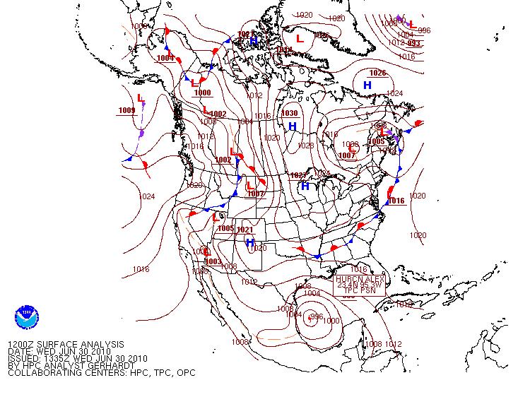
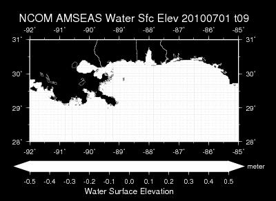
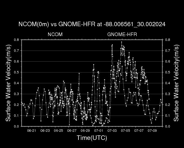
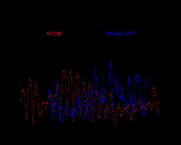
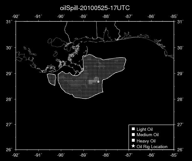
2 The influence of cyclones on the Deepwater Horizon Oil Spill Oil spill simulation from 6/20/10-7/10/10 using AMSEAS NCOM data Note inshore movement of oil starting late June
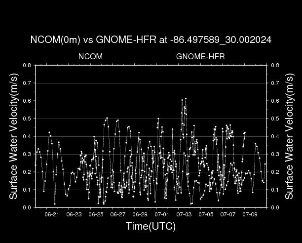
3 Model description Lagrangian particle tracker with random walk diffusion Input consisted i. latitude and longitude parcel positions in the oil-contaminated area ii. wind (validation show reasonably accurate with absolute errors of 1.4 ms -1 and 33 deg). iii. Current (validation to be shown in this talk) iv. array of pseudo-random numbers (from Mersenne Twister algorithm, initial seed from machine noise) New parcels were released damaged Macondo rig location at each timestep Twenty-five parcels were released at each position, and when combined with a 10 m 2 s -1 diffusion coefficient, resulted in a natural trajectory spread with time Initial positions based interpretation on i. NASA MODIS ii. SAR imagery from iii. NOAA/NESDIS Satellite Analysis Branch (SAB) experimental surface oil analysis products at iv. NOAA s Office of Response and Restoration oil trajectory maps at Parcels advected at 80% of the ocean current speed and at 3% of the wind speed. Bilinear interpolation of wind and current applied from model grid to parcel location.
4
5
6
7
8
9

10


11 Elevated water from Alex Elevated water from low
12
13
14

15
16
17 Summary Oil transport mostly governed by ocean currents However, surge events associated with tropical cyclones and non-tropical lows can push oil far into the marsh system Difficult to know if a hurricane landfall would have been catastrophic Hurricane tend to flush the ecosystem of pollutants But the potential of inland pollution existed. Our ADCIRC simulations (not shown) suggested deep movement of oil into the marsh system Fortunately, no hurricane landfall occurred.
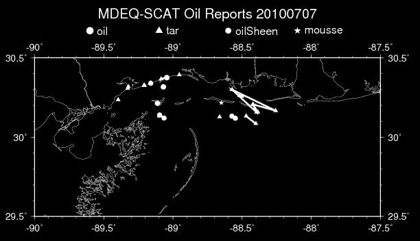
18 Merging of Oil Datasets Shoreline Cleanup and Assessment Technique (SCAT) datasets State DEQs Louisiana Bucket Brigade Lake Pontchartrain Basin Foundation Investigating other potential datasets Original purpose is to provide validation against the oil spill model after dispersion, emulsification, and evaporation/dissolution terms are added. However, it should be beneficial for other DWH research endeavors.
19
20
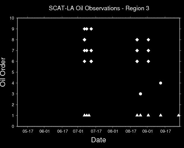
21 SCAT data The SCAT teams performed survey of affected shorelines and collected data on shoreline oiling conditions MS-AL SCAT data very coarse and only a few days. Not useful LA SCAT data covers most of the oil spill and ample datapoints Spreadsheet available and contains metadata However, many temporal data holes exist in different regions. This problem is common for all the datasets, and is the motivation for compositing all the datasets
22
23
24
25
26
27
28
29
30
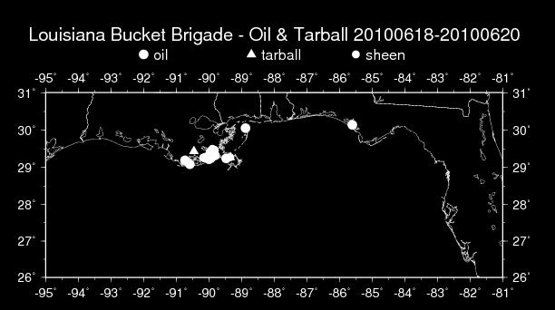
31 Louisiana Bucket Brigade data Volunteer organization which tabulated all oil spill news and information from the media, phone calls, s, etc. Available in a spreadsheet Covers the entire oil spill and plentiful datapoints Temporal data holes Dataset also contained news accounts, community meetings, tidbits such as smells from oil burning. These have been removed Latitude and longitude not always included, just a specific location. We have added an estimated latitude and longitude if possible
32
33 State DEQ The DEQs released almost daily statements of oil spill information in pdf reports This data is not digitized. Covers different timeframes of the oil spill with modest datapoints MS DEQ contained latitude and longitude for most incidents. It also sometimes described geographic coverage, not just points. MSU has developed a spreadsheet of these reports. LA DEQ is similar, but covers the entire period and contains more data. However, it does not provide latitude and longitude. Geographic regions in the marsh or sounds are referenced instead. We are working on a spreadsheet, but it is tedious.

34 MDEQ dataset example

35 1. Chandeleur Islands 2. Eastern Biloxi Marsh 3. LakeBorge / LakePontchartrain 4. Mississippi River Mouth 5. Sandy Point 6. Barataria Bay North End 7. Grand Isle / Fourchon 8. Terrebonne Bay / Timbalier Bay North End 9. Last Islands 10. Atchafalaya Delta 11. Russell Sage Mash / Vermillion Bay / West Cote Blanche Bay
36 Eastern Biloxi Marsh

37 Lake Borgne and Lake Pontchartrain
38 Northern Barataria Bay

39 Grand Isle and Fourchon
40 Future work Development of oil spill databases for Louisiana DEQ and Lake Pontchartrain Basin Foundation Synthesize datasets for comprehensive analysis Analysis of all databases, with a summary of all oil incursion along coastline region, wetlands, and in the open waters Incorporate dispersion and evaporation components into oil spill model Validate oil spill model against database Overall goal: fate and transport analysis

41
Pat Fitzpatrick, Yee Lau, Chris Hill, and Haldun Karan Geosystems Research Institute Mississippi State University
 COAMPS wind validation in the NCOM Intra-American Seas (AMSEAS) domain in the Gulf of Mexico during 20 June to 10 July 2010, and the use of NCOM and COAMPS data to examine the impact of cyclones on the
An Integrated Storm Surge, Hurricane Wave, Salinity and Sediment Transport Modeling System for Breton Sound, LA
 An Integrated Storm Surge, Hurricane Wave, Salinity and Sediment Transport Modeling System for Breton Sound, LA Q. Jim Chen Department of Civil and Environmental Engineering qchen@lsu.edu Acknowledgements
Wetland attenuation of Hurricane Rita s storm surge
 Wetland attenuation of Hurricane Rita s storm surge Pat Fitzpatrick, Yee Lau, Yongzuo Li, Nam Tran, Chris Hill, and Suzanne Shean Geosystems Research Institute, Mississippi State University Sponsors: NOAA
University of New Orleans. Karen Westphal University of New Orleans Pontchartrain Institute for Environmental Sciences
 University of New Orleans ScholarWorks@UNO Pontchartrain Institute Reports and Studies Pontchartrain Institute for Environmental Sciences (PIES) 1-2009 Louisiana Barrier Island Comprehensive Monitoring
An analysis of storm surge attenuation by wetlands using USGS, FEMA, and NASA data
 An analysis of storm surge attenuation by wetlands using USGS, FEMA, and NASA data Pat Fitzpatrick Geosystems Research Institute Mississippi State University Walter Peterson and Courtney Buckley NASA Marshall
Modeling Nearshore Waves for Hurricane Katrina
 Modeling Nearshore Waves for Hurricane Katrina Jane McKee Smith US Army Engineer Research & Development Center Coastal and Hydraulics Laboratory Outline Introduction Modeling Approach Hurricane Katrina
Erich Gundlach, Ph.D.
 Oil Shoreline Interactions: Deepwater Horizon SETAC Boston, November 2011 Erich Gundlach, Ph.D. E-Tech International Inc. New York, USA ErichEti@ cs.com www.oil-spill-info.com What s Going On Shorelines
Extent and Degree of Shoreline Oiling: Deepwater Horizon (DWH) Oil Spill, Scott Zengel Research Planning, Inc. Tallahassee, Florida
 Oil Spill, Scott Zengel Research Planning, Inc. Tallahassee, Florida") Extent and Degree of Shoreline Oiling: Deepwater Horizon (DWH) Oil Spill, 2010 2013 Scott Zengel Research Planning, Inc. Tallahassee, Florida Background & Definitions SCAT survey data presented here SCAT
Extent and Degree of Shoreline Oiling: Deepwater Horizon (DWH) Oil Spill, 2010 2013 Scott Zengel Research Planning, Inc. Tallahassee, Florida Background & Definitions SCAT survey data presented here SCAT
PREDICTION OF OIL SPILL TRAJECTORY WITH THE MMD-JMA OIL SPILL MODEL
 PREDICTION OF OIL SPILL TRAJECTORY WITH THE MMD-JMA OIL SPILL MODEL Project Background Information MUHAMMAD HELMI ABDULLAH MALAYSIAN METEOROLOGICAL DEPARTMENT(MMD) MINISTRY OF SCIENCE, TECHNOLOGY AND INNOVATION
Hurricane Katrina and Oil Spills: Impact on Coastal and Ocean Environments
 Archived version from NCDOCKS Institutional Repository http://libres.uncg.edu/ir/asu/ Pine, J. C. (June 2006). Hurricane Katrina and oil spills: Impact on coastal and ocean environments. Oceanography,
General background on storm surge. Pat Fitzpatrick and Yee Lau Mississippi State University
 General background on storm surge Pat Fitzpatrick and Yee Lau Mississippi State University Storm surge is an abnormal rise of water associated with a cyclone, not including tidal influences Low pressure
Impact & Recovery of Wetland Plant Communities after the Gulf Oil Spill in 2010 and Hurricane Isaac in 2012
 Impact & Recovery of Wetland Plant Communities after the Gulf Oil Spill in 2010 and Hurricane Isaac in 2012 Introduction: The coastal wetlands, estuaries and lagoon systems of the Gulf Coast are a hotspot
Authors of abstract. Pat Fitzpatrick Jessie Kastler Frank Hernandez Carla Culpepper Candace Bright. But whole CONCORDE team contributed to results
 Authors of abstract Pat Fitzpatrick Jessie Kastler Frank Hernandez Carla Culpepper Candace Bright MSU USM USM USM USM But whole CONCORDE team contributed to results Outline of talk Field program information
Zhi Long Liu, Daniel Shen. Instructor: Alex Bayen
 Student: Zhi Long Liu, Daniel Shen Instructor: Alex Bayen Advisor: Raja Sengupta Background Problem Statement Simulations Error Analysis Analytical Model Conclusion Future Works Interaction with ocean
Visualizing hurricanes
 Visualizing hurricanes NAME: DATE: Scientific visualization is an integral part of the process of simulating natural phenomena. In the computational sciences, the main goal is to understand the workings
University of New Orleans. Karen Westphal University of New Orleans Pontchartrain Institute for Environmental Sciences
 University of New Orleans ScholarWorks@UNO Pontchartrain Institute Reports and Studies Pontchartrain Institute for Environmental Sciences (PIES) 1-2009 Louisiana Barrier Island Comprehensive Monitoring
GIS 2010: Coastal Erosion in Mississippi Delta
 1) Introduction Problem overview To what extent do large storm events play in coastal erosion rates, and what is the rate at which coastal erosion is occurring in sediment starved portions of the Mississippi
Coastal Ocean Circulation Experiment off Senegal (COCES)
") DISTRIBUTION STATEMENT A. Approved for public release; distribution is unlimited. Coastal Ocean Circulation Experiment off Senegal (COCES) Pierre-Marie Poulain Istituto Nazionale di Oceanografia e di Geofisica
DISTRIBUTION STATEMENT A. Approved for public release; distribution is unlimited. Coastal Ocean Circulation Experiment off Senegal (COCES) Pierre-Marie Poulain Istituto Nazionale di Oceanografia e di Geofisica
PAJ Oil Spill Simulation Model for the Sea of Okhotsk
 PAJ Oil Spill Simulation Model for the Sea of Okhotsk 1. Introduction Fuji Research Institute Corporation Takashi Fujii In order to assist in remedial activities in the event of a major oil spill The Petroleum
Hurricane Season 2010 & NOAA s Deepwater Response
 Hurricane Season 2010 & NOAA s Deepwater Response What s Happened? What Will 2010 Bring? Possible Shoreline Effects Darin Figurskey Meteorologist-in-Charge NOAA s NWS Raleigh, NC NOAA s National Weather
Hurricane Tracks. Isaac versus previous storms Impacts and solutions. ( Continue by clicking on the slide bar to the right)
") Hurricane Tracks Isaac versus previous storms Impacts and solutions ( Continue by clicking on the slide bar to the right) 1 Hurricane Tracks 2 Sample Hurricanes The sample hurricanes selected were chosen
Hurricane Tracks Isaac versus previous storms Impacts and solutions ( Continue by clicking on the slide bar to the right) 1 Hurricane Tracks 2 Sample Hurricanes The sample hurricanes selected were chosen
Coastal Litigation in the Context of Science Literacy
 Coastal Litigation in the Context of Science Literacy Chris McLindon New Orleans Geological Society February 6, 7 Science Literacy The value of community participation in scientific research is widely
Frank Revitte National Weather Service. Weather Forecast Office New Orleans/Baton Rouge
 Frank Revitte National Weather Service Weather Forecast Office New Orleans/Baton Rouge Above normal activity 17 Total Named Storms 7 Tropical Storms 4 Hurricanes 6 Major Hurricanes Not the most active,
Introduction. One way to monitor the status of this energy is though monitoring sea surface
 Sears 1 Understanding Hurricane Intensity Using Sea Surface Height and Temperature Information John Sears (Plymouth State University) Robbie Hood (NASA-MSFC) Frank LaFontaine (Raytheon) Abstract Warmer
Case study analysis of the Real-Time Mesoscale Analysis (RTMA) in the northern Gulf of Mexico
 in the northern Gulf of Mexico") Case study analysis of the Real-Time Mesoscale Analysis (RTMA) in the northern Gulf of Mexico Pat Fitzpatrick and Yee Lau Mississippi State University Stennis Space Center, MS Description of research consortium
Case study analysis of the Real-Time Mesoscale Analysis (RTMA) in the northern Gulf of Mexico Pat Fitzpatrick and Yee Lau Mississippi State University Stennis Space Center, MS Description of research consortium
Storm Surge Frequency Analysis using a Modified Joint Probability Method with Optimal Sampling (JPM-OS)
") Storm Surge Frequency Analysis using a Modified Joint Probability Method with Optimal Sampling (JPM-OS) Jay Ratcliff Coastal Hydraulics Lab, of Engineers (USACE) Engineering Research and Development Center
Storm Surge Frequency Analysis using a Modified Joint Probability Method with Optimal Sampling (JPM-OS) Jay Ratcliff Coastal Hydraulics Lab, of Engineers (USACE) Engineering Research and Development Center
Hypoxia in the Northern Gulf of Mexico in 2010: was the Deepwater Horizon Oil Spill a Factor? Nathaniel E. Ostrom
 Agricultural Outlook Forum Presented: February 24-25, 2011 U.S. Department of Agriculture Hypoxia in the Northern Gulf of Mexico in 2010: was the Deepwater Horizon Oil Spill a Factor? Nathaniel E. Ostrom
Lab 12 Coastal Geology
 Lab 12 Coastal Geology I. Fluvial Systems Hydrologic Cycle Runoff that flows into rivers = precipitation (rain and snowmelt) [infiltration (loss to groundwater) + evaporation (loss to atmosphere) + transpiration
Surface Trajectories of Oil Transport along the Northern Coastline of the Gulf of Mexico
 Surface Trajectories of Oil Transport along the Northern Coastline of the Gulf of Mexico JC Dietrich a,, CJ Trahan a,1, MT Howard b, JG Fleming c, RJ Weaver d,2, S Tanaka e,3, L Yu f, RA Luettich Jr d,
What is CERA? Coastal Emergency Risks Assessment
 What is CERA? Coastal Emergency Risks Assessment Visualization tool using OGC standards Displays the outputs from the ADCIRC storm surge model or other coastal models Represents the maps on interactive
ASSESSMENT AND RESTORATION OF COASTAL ECOSYSTEMS USING REMOTE SENSING AND VISUALIZATION TOOLS FOR THE GULF OF MEXICO AND BEYOND
 ASSESSMENT AND RESTORATION OF COASTAL ECOSYSTEMS USING REMOTE SENSING AND VISUALIZATION TOOLS FOR THE GULF OF MEXICO AND BEYOND Remote Sensing as a Tool for Ecosystem Restoration George Graettinger Office
SLOSH New Orleans Basin 2012 Update
 SLOSH New Orleans Basin 2012 Update Michael Koziara Science and Operations Officer National Weather Service Slidell, LA The Basics What is storm surge? What is SLOSH? Details Assumptions Inundation = Storm
Quantifying effects of oil on coastal dune vegetation. Thomas Miller and Elise Gornish Biological Science, Florida State University
 Quantifying effects of oil on coastal dune vegetation Thomas Miller and Elise Gornish Biological Science, Florida State University Natural History of Barrier Islands in the Northern Gulf Make up ~70% of
Inflow of shelf waters into the Mississippi Sound and Mobile Bay estuaries in October 2015
 1 Inflow of shelf waters into the Mississippi Sound and Mobile Bay estuaries in October 2015 2 3 4 5 6 7 8 9 10 11 Mustafa Kemal Cambazoglu 1, I.M. Soto 1, S.D. Howden 1, B.Dzwonkowski 2,3, P.J. Fitzpatrick
HURRICANE NATE BRIEFING
 HURRICANE NATE BRIEFING 2:00 PM CDT Saturday, October 07, 2017 Prepared by: NWS NWSNewOrleans www.weather.gov/neworleans Situation Overview continues to intensify. It is now forecast to be a category 2
Weather and Climate Summary and Forecast November 2017 Report
 Weather and Climate Summary and Forecast November 2017 Report Gregory V. Jones Linfield College November 7, 2017 Summary: October was relatively cool and wet north, while warm and very dry south. Dry conditions
Amina Rangoonwala and Elijah Ramsey III Wetland and Aquatic Research Center. U.S. Geological Survey. Lafayette, LA
 First I will show examples of radar mapping of hurricane surge extent and duration and optical mapping of the resultant marsh dieback along the Louisiana coast Next we extend these works to hurricane Sandy
New NASA Ocean Observations and Coastal Applications
 New NASA Ocean Observations and Coastal Applications Duane Armstrong Chief, Applied Science & Technology Project Office August 20, 2014 1 Outline NASA s new Earth Science Ocean Science Missions for 2014
The AIR Tropical Cyclone Model for India
 The AIR Tropical Cyclone Model for India Tropical cyclones have caused millions, and even billions, of dollars in damage in India. The growing number of properties on the coast, together with growing insurance
Storm surge modeling at RSMC La Réunion. Cliquez pour modifier le style des sous-titres du masque
 Storm surge modeling at RSMC La Réunion Cliquez pour modifier le style du titre Cliquez pour modifier le style des sous-titres du masque 6th session training course of tropical cyclones (28 oct. 5 nov.
Comparative Analysis of Hurricane Vulnerability in New Orleans and Baton Rouge. Dr. Marc Levitan LSU Hurricane Center. April 2003
 Comparative Analysis of Hurricane Vulnerability in New Orleans and Baton Rouge Dr. Marc Levitan LSU Hurricane Center April 2003 In order to compare hurricane vulnerability of facilities located in different
In June 2009, the National Aeronautics and Space
 Radar Remote Sensing of the Louisiana Wetlands to Study Delta Formation and Marsh Status The National Aeronautics and Space Administration (NASA) has been collecting images of Louisiana s Gulf Coast since
THC-T-2013 Conference & Exhibition
 Modeling of Shutter Coastal Protection against Storm Surge for Galveston Bay C. Vipulanandan, Ph.D., P.E., Y. Jeannot Ahossin Guezo and and B. Basirat Texas Hurricane Center for Innovative Technology (THC-IT)
Your web browser (Safari 7) is out of date. For more security, comfort and the best experience on this site: Update your browser Ignore
 is out of date. For more security, comfort and the best experience on this site: Update your browser Ignore") Your web browser (Safari 7) is out of date. For more security, comfort and the best experience on this site: Update your browser Ignore MAPPING U P THE SPIL L Louisiana Bucket Brigade helps Gulf Coast
Your web browser (Safari 7) is out of date. For more security, comfort and the best experience on this site: Update your browser Ignore MAPPING U P THE SPIL L Louisiana Bucket Brigade helps Gulf Coast
Land Area Changes in Coastal Louisiana After Hurricanes Katrina and Rita
 Land Area Changes in Coastal Louisiana After Hurricanes Katrina and Rita By John A. Barras Comparison of classified Landsat Thematic Mapper (TM) satellite imagery acquired before and after the landfalls
Utilizing In Situ Observations and Satellite Measurements to Examine the Extent and. Gustavo Jorge Goni presented by Ryan Smith NOAA / AOML Miami, FL
 Utilizing In Situ Observations and Satellite Measurements to Examine the Extent and Variability of the DWH Oil Spill Gustavo Jorge Goni presented by Ryan Smith NOAA / AOML Miami, FL NTSC SOST 2011 Deepwater
Coastal Response Research Center. Nancy Kinner University of New Hampshire (UNH) Michele Jacobi NOAA ORR. September 27, 2007
 Michele Jacobi NOAA ORR. September 27, 2007") Coastal Response Research Center Nancy Kinner University of New Hampshire (UNH) Michele Jacobi NOAA ORR September 27, 2007 1 Coastal Response Research Center (CRRC) CRRC is partnership between NOAA s Office
Coastal Response Research Center Nancy Kinner University of New Hampshire (UNH) Michele Jacobi NOAA ORR September 27, 2007 1 Coastal Response Research Center (CRRC) CRRC is partnership between NOAA s Office
Monitoring Coastal Marshes for Persistent Saltwater Intrusion
 Monitoring Coastal Marshes for Persistent Saltwater Intrusion Maria Kalcic, 1 Callie Hall, 2 Jeff Russell, 3 and Rose Fletcher 1 1 Science Systems and Applications, Inc., Bldg. 1105, John C. Stennis Space
Science & Monitoring to Assess the Success of Restoration Projects related to the DWH Oil Spill & Natural Resource Damage Assessment and Restoration
 Science & Monitoring to Assess the Success of Restoration Projects related to the DWH Oil Spill & Natural Resource Damage Assessment and Restoration Alyssa Dausman & Jo Ellen Hinck U.S. Geological Survey
Eco-hydromorphic Characterization of the Louisiana Coastal Region Using Multiple Remotely Sensed Data Sources and Analyses
 National Wetlands Research Center Eco-hydromorphic Characterization of the Louisiana Coastal Region Using Multiple Remotely Sensed Data Sources and Analyses 1Holly Beck, 2 Brady Couvillion, 1 Nadine Trahan
Hurricanes and Their Tracks
 LESSON PLAN 1 Hurricanes 3 5 Hurricanes and Their Tracks Children will know better what to expect of an approaching hurricane if they understand what a hurricane is and the weather associated with it.
NWS 13: NetCDF Wind/Pressure Inputs for ADCIRC
 NWS 13: NetCDF Wind/Pressure Inputs for ADCIRC Alex Crosby Oceanweather Inc. Casey Dietrich NC State University 2018 ADCIRC User s Group Meeting Summary Motivation NetCDF Structure/Schema Implementation
Integrating new coastline information and geographically coordinated coastal geomorphology data
 Integrating new coastline information and geographically coordinated coastal geomorphology data NOAA Contemporary Shoreline DOE Coastal Geomorphology Cynthia Miller Corbett Jeff Simley 1 National Hydrography
THE IMPORTANCE OF SCIENCE IN COASTAL RESTORATION IN LOUISIANA
 THE IMPORTANCE OF SCIENCE IN COASTAL RESTORATION IN LOUISIANA Barb Kleiss USACE, Mississippi Valley Division August 3, 2011 LCA S&T Office Authorized under WRDA 2007 Designed to address technical issues
Index. Note: Page numbers with italicized f and t refer to figures and tables
 Index Note: Page numbers with italicized f and t refer to figures and tables A Absolutely Local Index of Change of Environment (ALICE), 23 acoustic Doppler current profilers (ADCPs), 119 additive noise,
Water Level Statistics for Design of Transportation Facilities in Coastal Louisiana
 64 TRANSPORTATION RESEARCH RECORD 1483 Water Level Statistics for Design of Transportation Facilities in Coastal Louisiana JOSEPH SUtJAYDA, MOHAMED ALAWADY, AND BABAK NAGHAVI Results are presented of an
Sea Level Rise and Hurricane Florence storm surge research methodology
 Sea Level Rise and Hurricane Florence storm surge research methodology Hurricane Florence storm surge analysis was conducted using a variety of input sources. In order to determine the maximum storm surge
Impacts of Hurricane Rita on the Beaches of Western Louisiana
 Impacts of Hurricane Rita on the Beaches of Western Louisiana By Hilary F. Stockdon, Laura A. Fauver, Asbury H. Sallenger, Jr., and C. Wayne Wright Hurricane Rita made landfall as a category 3 storm in
WIND EFFECTS ON CHEMICAL SPILL IN ST ANDREW BAY SYSTEM
 WIND EFFECTS ON CHEMICAL SPILL IN ST ANDREW BAY SYSTEM PETER C. CHU, PATRICE PAULY Naval Postgraduate School, Monterey, CA93943 STEVEN D. HAEGER Naval Oceanographic Office, Stennis Space Center MATHEW
Simulating the dispersal of aging oil from the Deepwater Horizon spill with a Lagrangian approach
 Simulating the dispersal of aging oil from the Deepwater Horizon spill with a Lagrangian approach Elizabeth W. North 1, E. Eric Adams 2, Zachary Schlag 1, Christopher R. Sherwood 3, Rouying He 4, Kyung
2 Georgia: Its Heritage and Its Promise
 TERMS region, erosion, fault, elevation, Fall Line, aquifer, marsh, climate, weather, precipitation, drought, tornado, hurricane, wetland, estuary, barrier island, swamp PLACES Appalachian Mountains, Appalachian
Bay Drift. An activity for middle or high school students on ocean currents, marine debris, and citizen science, created by CARTHE
 Bay Drift An activity for middle or high school students on ocean currents, marine debris, and citizen science, created by CARTHE (Part of the Ocean Currents & Oil Spills STEAM Lessons by CARTHE and Piano
PRESS RELEASE LOUISIANA UNIVERSITIES MARINE CONSORTIUM July 31, 2011
 PRESS RELEASE LOUISIANA UNIVERSITIES MARINE CONSORTIUM July 31, 2011 Scientists have returned from mapping the 2011 area of hypoxia, commonly known as the Dead Zone, along the Louisiana coast. This year
WEDNESDAY 30 TH AUGUST, :57 p.m. Tropical Storm Irma forms in the Atlantic. Don t let your guard down, always #Be Ready.
 Chapter 1 - The Set Up In the days leading up to Irma a series of composed and sobering text messages, presented in truncated form below, from Department of Disaster Management warned us of the pending
Boil Model. Back Tracking of Oil Slick Movements in Offshore of Arabian Gulf Marine Waters. Developed By. Khaled Al-Salem April 2013
 Boil Model Back Tracking of Oil Slick Movements in Offshore of Arabian Gulf Marine Waters Developed By Khaled Al-Salem April 2013 COASTAL AND AIR POLLUTION DEPARTMENT KUWAIT INSTITUTE FOR SCIENTIFIC RESEARCH
Development of Operational Storm Surge Guidance to Support Total Water Predictions
 Development of Operational Storm Surge Guidance to Support Total Water Predictions J. Feyen 1, S. Vinogradov 1,2, T. Asher 3, J. Halgren 4, Y. Funakoshi 1,5 1. NOAA/NOS//Development Laboratory 2. ERT,
At the Midpoint of the 2008
 At the Midpoint of the 2008 Atlantic Hurricane Season Editor s note: It has been an anxious couple of weeks for those with financial interests in either on- or offshore assets in the Gulf of Mexico and
CHAPTER 1: EXPLORING GEOGRAPHY
 CHAPTER 1: EXPLORING GEOGRAPHY Please Do Now: In your PDN section of your binder answer the following with one or two sentences: What is Geography? What is Geography? The study of where people, places,
AN INTEGRATED MODELING APPROACH FOR SIMULATING OIL SPILL AT THE STRAIT OF BOHAI SEA. Jinhua Wang 1 and Jinshan Zhang 1
 AN INTEGRATED MODELING APPROACH FOR SIMULATING OIL SPILL AT THE STRAIT OF BOHAI SEA Jinhua Wang 1 and Jinshan Zhang 1 A three dimensional integrated model is developed for simulating oil spills transport
Groundwater dynamics and surface water-groundwater interaction in a prograding delta island, Louisiana, USA
 Supplementary Information Groundwater dynamics and surface water-groundwater interaction in a prograding delta island, Louisiana, USA Michael T. O Connor 1* and Kevan B. Moffett 1,2 1 Department of Geological
The World of Geography Pre-Test/Study Guide Chapter 1 Test
 Read each statement or question. On the lines below write the letter of the best answer. 1. Geographers look at the Earth 5. What are the two specific A. by studying cities first. measurements of Earth
MUDMAP TM. Software Description
 ASA Applied Science Associates, Inc. 70 Dean Knauss Drive Narragansett, RI 02882-1143 U.S.A. Tel: 401-789-6224 Fax: 401-789-1932 asa@asascience.com www.asascience.com MUDMAP TM Software Description MUDMAP
Field Research Facility
 Field Research Facility Sea Level Rise Observations of Sea Level rise Forces driving change Predicting future Sea Level rise Response of land surface Storm inundation coupled with Sea Level Dr. Jesse McNinch
Wind Effects on the Choctawhatchee River Plume at Destin Inlet, Florida
 Wind Effects on the Choctawhatchee River Plume at Destin Inlet, Florida Rosemary Cyriac 1, Casey Dietrich 1, Arash Fathi 2, Clint Dawson 2, Kendra Dresback 3, Cheryl Ann Blain 4, Matthew Bilskie 5, Scott
Phases of Disaster Response. John Yeaw, Gavin Vanstone, Haochen Wu, Jordan Tyler
 Phases of Disaster Response John Yeaw, Gavin Vanstone, Haochen Wu, Jordan Tyler BP Oil Spill One of the worst man made disasters in human history The BP oil spill occurred in April of 2010 when the Deepwater
Optimal Design of Sediment Diversions for Delta Restoration: lessons learned from examples
 Optimal Design of Sediment Diversions for Delta Restoration: lessons learned from examples Samuel Bentley 1, Angelina Freeman 2, Clinton S. Willson 1, Liviu Giosan 3, Jaye Cable 4 1 LSU 2 EDF 3 WHOI 4
Add NOAA nowcoast Layers to Maps
 WebEOC Maps Add-on Quick Reference Guide Add NOAA nowcoast Layers to Maps Overview With Maps Add-on, you can configure an unlimited number of map layers. These layers allow you to control the data you
Background Field program information Examples of measurements Wind validation for synthetic modeling effort
 Background Field program information Examples of measurements Wind validation for synthetic modeling effort How do complex fine-scale structure and processes in coastal waters dominated by pulsed-river
Are You Ready For Hurricane Season? 2018 Hurricane Talk B Y : S T O R M T E A M 8 M E T E O R O L O G I S T J U L I E P H I L L I P S
 Are You Ready For Hurricane Season? 2018 Hurricane Talk B Y : S T O R M T E A M 8 M E T E O R O L O G I S T J U L I E P H I L L I P S About Me I am Currently a Weekday Meteorologist at WFLA Channel 8.
CATEX Hurricane Zachary
 CATEX Hurricane Zachary EXERCISE, EXERCISE,EXERCISE East Coast CATEX Power Restoration Functional Exercise 2013 This document was prepared under a grant from FEMA's Grants Programs Directorate, U.S. Department
Forecasting Gulf of Mexico Hypoxia under Scenarios of Watershed and River Management
 Forecasting Gulf of Mexico Hypoxia under Scenarios of Watershed and River Management Dubravko Justic and Lixia Wang Department of Oceanography and Coastal Sciences College of the Coast and Environment
HAZUS th Annual Conference
 HAZUS 2014 7 th Annual Conference VALIDATING THE HAZUS COASTAL SURGE MODEL FOR SUPERSTORM SANDY Spiridon Katehis 1 Jordan T. Hastings 1 1 University of Southern California 1 Superstorm Sandy, Oct 12 2
Coastal Ocean Circulation Experiment off Senegal (COCES)
") DISTRIBUTION STATEMENT A: Approved for public release; distribution is unlimited. Coastal Ocean Circulation Experiment off Senegal (COCES) Pierre-Marie Poulain Istituto Nazionale di Oceanografia e di Geofisica
DISTRIBUTION STATEMENT A: Approved for public release; distribution is unlimited. Coastal Ocean Circulation Experiment off Senegal (COCES) Pierre-Marie Poulain Istituto Nazionale di Oceanografia e di Geofisica
Mapping Surface Oil Extent from the Deepwater Horizon Oil Spill Using ASCAT Backscatter
 Mapping Surface Oil Extent from the Deepwater Horizon Oil Spill Using ASCAT Backscatter Richard D. Lindsley and David G. Long Microwave Earth Remote Sensing Laboratory Brigham Young University Provo, UT
Appendix A STORM SURGE AND WAVE HEIGHT ANALYSIS
 Appendix A STORM SURGE AND WAVE HEIGHT ANALYSIS Memo To: Jeff Robinson, P.E., GEC, Inc. From: Silong Lu, Ph.D., P.E., D.WRE, Dynamic Solutions, LLC. Date: 1/9/2014 CC: Re: Chris Wallen, Vice President,
Post-Hurricane Recovery: How Long Does it Take?
 Post-Hurricane Recovery: How Long Does it Take? Implications for disaster recovery after hurricanes Harvey and Irma In the following report, BuildFax analyzed the geographic areas impacted by three of
Environmental Documents Prepared for Proposed Oil, Gas, and Mineral Operations by the Gulf of Mexico Outer Continental Shelf (OCS) Region
 Region") This document is scheduled to be published in the Federal Register on 03/27/2012 and available online at http://federalregister.gov/a/2012-07364, and on FDsys.gov Billing Code: 4310-MR DEPARTMENT OF THE
This document is scheduled to be published in the Federal Register on 03/27/2012 and available online at http://federalregister.gov/a/2012-07364, and on FDsys.gov Billing Code: 4310-MR DEPARTMENT OF THE
GEOGRAPHY (029) CLASS XI ( ) Part A: Fundamentals of Physical Geography. Map and Diagram 5. Part B India-Physical Environment 35 Marks
 CLASS XI ( ) Part A: Fundamentals of Physical Geography. Map and Diagram 5. Part B India-Physical Environment 35 Marks") GEOGRAPHY (029) CLASS XI (207-8) One Theory Paper 70 Marks 3 Hours Part A Fundamentals of Physical Geography 35 Marks Unit-: Geography as a discipline Unit-3: Landforms Unit-4: Climate Unit-5: Water (Oceans)
GEOGRAPHY (029) CLASS XI (207-8) One Theory Paper 70 Marks 3 Hours Part A Fundamentals of Physical Geography 35 Marks Unit-: Geography as a discipline Unit-3: Landforms Unit-4: Climate Unit-5: Water (Oceans)
Maximization of Historical Severe Precipitation Events over American, Yuba and Feather River Basins
 Maximization of Historical Severe Precipitation Events over merican, Yuba and Feather River Basins M. L. Kavvas 1, K. Ishida 1, S. Jang 1, N. Ohara 2, Z.Q.Chen 3, and M. nderson 3 1 University Of California,
Report on the Damage Survey Caused by Hurricane Katrina (Tentative Report)
") Report on the Damage Survey Caused by Hurricane Katrina (Tentative Report) November 1, 2005 Coastal Disaster Prevention Technology Survey Team 1. Introduction Hurricane Katrina struck the United States
Report on the Damage Survey Caused by Hurricane Katrina (Tentative Report) November 1, 2005 Coastal Disaster Prevention Technology Survey Team 1. Introduction Hurricane Katrina struck the United States
WELCOME TO THE 2018 RA-IV WORKSHOP ON HURRICANE FORECASTING AND WARNING
 WELCOME TO THE 2018 RA-IV WORKSHOP ON HURRICANE FORECASTING AND WARNING Richard J. Pasch and Daniel P. Brown Senior Hurricane Specialists National Hurricane Center ORIENTATION Use of PCs NHC Facility Workshop
hurricane. Alabama Course of weather and climate cyclones. accompany hurricanes.
 Visualizing hurricanes A multimedia lesson about hurricanes, storm surge, and scientific visualizations from models OBJECTIVE: Students will able to differentiate between storm surge elevation and inundation
ERDC Support for Hurricane Sandy
 ERDC Support for Hurricane Sandy Chris Massey, CHL; Aaron Byrd, CHL; Nawa Pradhan, CHL; Jeff Melby, CHL; Jane Smith, CHL; Robert Walker, ITL; and Jennifer Wozencraft, JALBTCX ERDC Support for Hurricane
Coastal Oceanography. Coastal Oceanography. Coastal Waters
 Coastal Oceanography Coastal Oceanography 95% of ocean life is in coastal waters (320 km from shore) Estuaries and wetlands are among most productive ecosystems on Earth Major shipping routes, oil and
Dissipation due to Vegetation in Nearshore Wave Models
 Dissipation due to Vegetation in Nearshore Wave Models Jane McKee Smith US Army Engineer Research and Development Center, Coastal and Hydraulic Laboratory Alison Sleath Grzegorzewski, New Orleans District
USACE-ERDC Coastal Storm Modeling System Updates Chris Massey, PhD
 USACE-ERDC Coastal Storm Modeling System Updates Chris Massey, PhD Research Mathematician USACE-ERDC Coastal & Hydraulics Lab Chris.Massey@usace.army.mil ERDC s Coastal Storm-Modeling System (ERDC CSTORM-MS)
The Global Width Database for Large Rivers. (GWD-LR) version 1.2
 version 1.2") GWD-LR ver1.2 August 2014 1 2 The Global Width Database for Large Rivers (GWD-LR) version 1.2 3 4 5 Dai Yamazaki JAMSTEC Japan Agency for Marine Earth Science and Technology d-yamazaki@jamstec.go.jp 6
GWD-LR ver1.2 August 2014 1 2 The Global Width Database for Large Rivers (GWD-LR) version 1.2 3 4 5 Dai Yamazaki JAMSTEC Japan Agency for Marine Earth Science and Technology d-yamazaki@jamstec.go.jp 6
Cause, Assessment & Management of Flood Hazards associated with Landfalling Tropical Cyclones & Heavy Rain
 Cause, Assessment & Management of Flood Hazards associated with Landfalling Tropical Cyclones & Heavy Rain by CHEN Charng Ning, Professor Emeritus Nanyang Technological University (NTU), Singapore Consultant,
Homework 8: Hurricane Damage (adapted from Pipkin et al.)
") 1 Homework 8: Hurricane Damage (adapted from Pipkin et al.) Tropical cyclones have a significant impact on coastal areas of the world. In the Atlantic and Eastern Pacific Oceans they are called hurricanes
1 Homework 8: Hurricane Damage (adapted from Pipkin et al.) Tropical cyclones have a significant impact on coastal areas of the world. In the Atlantic and Eastern Pacific Oceans they are called hurricanes
29th Conference on Hurricanes and Tropical Meteorology, May 2010, Tucson, Arizona
 P2.96 A SIMPLE COASTLINE STORM SURGE MODEL BASED ON PRE-RUN SLOSH OUTPUTS 1. INTRODUCTION Liming Xu* FM Global Research, 1151 Boston Providence Turnpike, Norwood, MA 02062 Storm surge is an abnormal rise