Using Remote Sensing Technologies to Improve Resilience
|
|
|
- Olivia Baldwin
- 5 years ago
- Views:
Transcription
1 4 Using Remote Sensing Technologies to Improve Resilience Ronald T. Eguchi CEO, ImageCat, Inc.
2 6 years ago The world had just survived the Y2K bug with no major incidents Nations around the world commit to extend the use of space facilities for disaster response (UN Charter on Space and Major Disasters) Smooth, Santana featuring Rob Thomas was the #1 hit in the U.S.
3 5 years ago The U.S. was reacting to 9/11 The first sub-meter high-resolution commercial satellite was launched by DigitalGlobe The Bhuj, India earthquake occurred killing over 20,000 people and leaving over 600,000 homeless
4 4 years ago European Space Agency successfully launches Envisat (Environmental Satellite) 9 different sensors Department of Homeland Security formed in response to terrorists concerns in the U.S.
5 3 years ago Earthquake in Bourmerdes region of northern Algeria - 2,200 killed A big heat wave in Paris has had temperatures up to 112ºF), killing more than 3,000 people. Widespread power outage affects northeast United States and Canada
6 2 years ago One of the worst natural disasters in recorded history hits southeastern Asia when the strongest earthquake in 40 years hits the entire Indian Ocean region. Over 200,000 killed and millions left without shelter. Hurricane Ivan strikes Gulf Shores, Alabama, as a Category 3 storm, killing 25 in Alabama and Florida becoming the 3rd costliest hurricane in American history
7 1 year ago Four explosions rock the transport network in London killing 56 people and injuring over 700 At least 1,604 are killed, and severe damage is caused along the U.S. Gulf Coast, as Hurricane Katrina strikes the Louisiana, Mississippi and Alabama coastal areas
8 Today Tremendous technological push especially in the areas of situational awareness The need for rapid damage assessment and resilient response systems has been strongly noted in many recent natural disasters In spite these factors, we continue to lag in our implementation of these technologies
9 Why is this happening? The efficacy of these technologies are not being fully recognized throughout the emergency management response chain Users are not fully educated on the use of these technologies for either pre- or postdisaster use
10 What needs to be done Stronger partnerships between the research community and end-users Better integration of beta products within industry A stronger commitment by government agencies to advance research to levels where research results and products can be more effectively transferred to technology integrators
11 In what ways has MCEER contributed to the solution? A long-term commitment to research in remote sensing with the ultimate goal of developing and transferring usable products to the emergency management community Organized and sponsored several U.S. and international workshops that have promoted genuine collaboration in post multi-hazard investigations and research Established the Remote Sensing Institute (RSI)
12 Remote Sensing Technologies Offer a Number of Solutions to Enhancing Resilience Rapidity provide rapid visual assessments of impact Robustness multiple sensors that collect a wide range of data and information on impacted areas Redundancy offer an alternative situation awareness capability Resourcefulness can aid in reconnaissance in areas that are not easily accessible
13 Specific Achievements in Remote Sensing Research 1. Created various techniques to quantify the built environment for large urban areas 2. Developed three-tiered approach to damage assessment 3. Developed and implemented post-disaster data collection and visualization systems 4. Expanded research to other hazards, including tsunamis, hurricanes and terrorist attacks
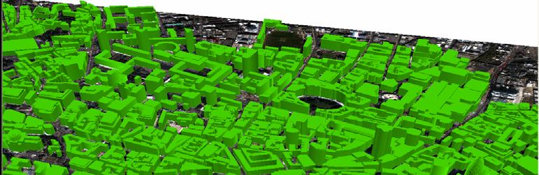
14 1. Building Inventory Development Created innovative techniques to extract buildings from high- and moderate-resolution optical satellite images Pioneered techniques to develop 3D models of cities; have augmented these models with information on building heights, number of stories, total square footage and structural classifications Implemented satellite-derived building inventory models in HAZUS
15 Building Footprint Extraction Using a series of filters, it is possible to create a bare-earth DEM (digital elevation model) of a city Another useful application of the model is the ability to delineate urbanized areas anywhere in the world using automated extraction algorithms

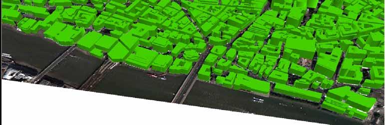
16 MIHEA Mono-Image Height Extraction Algorithm Methodology uses: single high-resolution satellite images and rational functions to replicate the parameters of the camera A major benefit of MIHEA is that a user ca create highly accurate 3D city models for anywhere in the world
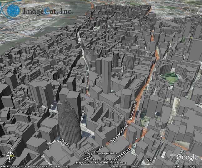
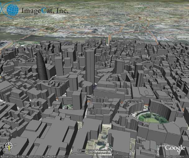
17 3D-London


18


19
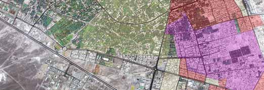
20 Integration of remote sensing technologies into loss estimation Inventory models continue to be a weak link in loss estimation process Remote sensing technologies offer an alternative to more traditional, timeintensive methods POTENTIAL HAZARDS DIRECT DAMAGE SOCIAL LOSSES ECONOMIC LOSSES INVENTORY DATA INDUCED DAMAGE INDIRECT LOSSES

21 2. Post-Earthquake Damage Assessment

22 3-Tiered Approach TIER 1. Regional Change detection using moderateresolution imagery provides a quick look regional damage assessment TIER 2. Neighborhood Detailed analysis of high-resolution imagery determines the level of damage within affected communities TIER 3. Per-building Results support the prioritization and coordination of field-based activities e.g. response and recovery, and field reconnaissance Disaster

23 Bam, Iran
24 Counting Collapsed Buildings Before Imagery After Imagery Pre-processing Segmentation Classification Building footprints Shrinking Object-analysis Differencing Textural change map Thresholding Number of collapsed buildings Damage detection algorithm
25 Pre-processing Before Before Imagery After Imagery Pre-processing Segmentation Differencing Classification Building footprints Shrinking Textural change map Thresholding Number of collapsed buildings After


26 Segmentation Before Imagery After Imagery Pre-processing Segmentation Differencing Classification Textural change map Building footprints Shrinking Thresholding Number of collapsed buildings Scale = 30 Color = 0.1 Smoothness = 1.0


27 Classification Before Imagery After Imagery Pre-processing Segmentation Differencing Classification Textural change map Building footprints Shrinking Thresholding Number of collapsed buildings Building Vegetation Shadow Other 900 training objects Accuracy = 75%


28 Building Footprints Before Imagery After Imagery Pre-processing Segmentation Differencing Classification Textural change map Building footprints Shrinking Thresholding Number of collapsed buildings Buildings Total estimated buildings = 19,211

29 Shrinking Before Imagery After Imagery Pre-processing Segmentation Differencing Classification Textural change map Building footprints Shrinking Thresholding Number of collapsed buildings Shrink factor = 3m
30 Differencing (Texture) Before Imagery After Imagery Before After Pre-processing Segmentation Classification Differencing Textural change map Change map Building footprints Shrinking Thresholding Number of collapsed buildings


31 Thresholding Before Imagery After Imagery Pre-processing Segmentation Differencing Classification Textural change map Building footprints Shrinking Thresholding Number of collapsed buildings Collapsed Not collapsed

32 Number of collapsed buildings Before Imagery After Imagery Pre-processing Segmentation Differencing Classification Building footprints Shrinking Textural change map Thresholding Number of collapsed buildings Collapsed buildings = 6,481 Not collapsed buildings = 9,021 Not classified = 3,709 Accuracy = 79%

33 3. Post-disaster Reconnaissance Implementation of VIEWS System Notebook-based data collection and visualization system Integrates GPSregistered digital video, digital photos, and observations with high-resolution satellite imagery
 Hurricane Dennis Hurricane Katrina (4 ) Hurricane Rita Hurricane Wilma 7 3 2 8 1 10")
34 VIEWS Deployments Bam, Iran earthquake Hurricane Charley Hurricane Ivan Parkfield earthquake Niigata, Japan earthquake 4 9 Thailand, Indian ocean tsunami (2) Hurricane Dennis Hurricane Katrina (4 ) Hurricane Rita Hurricane Wilma
35 VIEWS Example Hurricane Charley
36 4. Multi-Hazard Assessment World Trade Center Attacks 2004 Indian Ocean Earthquake and Tsunami 2004/2005 Hurricanes, including Hurricane Katrina

37 World Trade Center Attacks Acquisition and delivery needs to be streamlined Image processing algorithms designed for damage detection need to be developed in preparation for future events Remote sensing data will prove to be even more effective if personnel are trained their effective use

38 VIEWS Deployment in New Orleans after Hurricane Katrina
39
40

41 2004 Indian Ocean Earthquake and Tsunami Chang and Adams studied the dynamics of community resilience after disasters recovery Remote sensing used to characterize and then categorize damage in two domains: built environment and wetlands
42 1 Year from now The nation will have survived another active hurricane season 16 named storms; 10 hurricanes; six category 3 or higher GoogleEarth will be named best web-based tool for the year Cars will be named Best Picture of the Year
43 5 Years from now Use of remotely-sensed data will be commonplace among emergency response organizations Typical uses will include: a) creating intelligent models of all mega-cities, b) provide real-time coverage of all disasters via the internet; and c) essential tool in monitoring disaster recovery
44 20 Years from now A constellation of high-resolution optical satellites will offer 24/7 coverage of every urbanized area of the world An infrastructure for a global emergency response system will have been in operation for over a decade Michel Bruneau will be named Teacher of the Year by over 1000 of his most enthusiastic students; making him SUNY Teacher of the millennium
45 Thank you very much
Advanced Image Analysis in Disaster Response
 Advanced Image Analysis in Disaster Response Creating Geographic Knowledge Thomas Harris ITT The information contained in this document pertains to software products and services that are subject to the
HIGH RESOLUTION SATELLITE IMAGERY NEW PERSPECTIVES FOR THE EARTHQUAKE RISK MANAGEMENT
 HIGH RESOLUTION SATELLITE IMAGERY NEW PERSPECTIVES FOR THE EARTHQUAKE RISK MANAGEMENT Lucian CHIROIU Denis Diderot University, Pôle Image Laboratory Paris, France Geosciences Consultants Paris, France
Bridge Damage Assessment
 Remote Sensing for Post-disaster Bridge Damage Assessment Beverley J. Adams Ph.D. Charles K. Huyck Sungbin Cho Ronald T. Eguchi bja@imagecatinc.com Outline The Idea Damage Detection Algorithms Bridge Hunter
Mapping Coastal Change Using LiDAR and Multispectral Imagery
 Mapping Coastal Change Using LiDAR and Multispectral Imagery Contributor: Patrick Collins, Technical Solutions Engineer Presented by TABLE OF CONTENTS Introduction... 1 Coastal Change... 1 Mapping Coastal
AUTOMATED BUILDING DETECTION FROM HIGH-RESOLUTION SATELLITE IMAGE FOR UPDATING GIS BUILDING INVENTORY DATA
 13th World Conference on Earthquake Engineering Vancouver, B.C., Canada August 1-6, 2004 Paper No. 678 AUTOMATED BUILDING DETECTION FROM HIGH-RESOLUTION SATELLITE IMAGE FOR UPDATING GIS BUILDING INVENTORY
The Role of the Louisiana Geographic Information Center in the Response to Hurricane Katrina
 The Role of the Louisiana Geographic Information Center in the Response to Hurricane Katrina By: Jared Chapiewsky & Laura Brown For: URPL 969- GIS Applications in Response to Hurricane Katrina Date: March
Changes in Ecosystems - Natural Events
 Changes in Ecosystems - Natural Events 8A predict and describe how different types of catastrophic events impact ecosystems such as floods, hurricanes, or tornadoes Textbook pages: 396-406 How can ecosystems
Sentinel Asia Tsunami Working Group
 Sentinel Asia Tsunami Working Group Co-Chairman: Prof. Shunichi Koshimura Abdul Muhari, PhD 4 th Joint Project Team Meeting (JPTM 2017): Sentinel Asia STEP 3 Abdul MUHARI, PhD Ministry of Marine Affairs
GIS: a common operational picture for public safety and emergency management
 Safety and Security Engineering IV 455 GIS: a common operational picture for public safety and emergency management J. Perdikaris School of Engineering, University of Guelph, Canada Abstract Not so long
Introduction to Environmental Geology, 5e Case History: Indonesian Tsunami Indonesian Tsunami (2) Introduction Historic Tsunamis
 Introduction Historic Tsunamis") 1 2 3 4 5 6 7 8 9 Introduction to Environmental Geology, 5e Chapter 7 Tsunami Case History: Indonesian Tsunami December 26, 2004, within a few hours, close to 250,000 people were killed With no warning
1 2 3 4 5 6 7 8 9 Introduction to Environmental Geology, 5e Chapter 7 Tsunami Case History: Indonesian Tsunami December 26, 2004, within a few hours, close to 250,000 people were killed With no warning
Top 10 Actions a CIO Can Take to Prepare for a Hurricane
 May 2013 Walter E. Washington Convention Center Washington, DC Top 10 Actions a CIO Can Take to Prepare for a Hurricane Lessons learned from Hurricane Sandy Bill Venteicher Marketing Manager Dell Email
Crowdsourcing approach for large scale mapping of built-up land
 Crowdsourcing approach for large scale mapping of built-up land Kavinda Gunasekara Kavinda@ait.asia Geoinformatics Center Asian Institute of Technology, Thailand. Regional expert workshop on land accounting
Climate Risk Visualization for Adaptation Planning and Emergency Response
 Climate Risk Visualization for Adaptation Planning and Emergency Response NCR Flood Fact Finding Workshop Ricardo Saavedra ricardo@vizonomy.com Social Media, Mobile, and Big Data St. Peter s Basilica,
COMPREHENSIVE GIS-BASED SOLUTION FOR ROAD BLOCKAGE DUE TO SEISMIC BUILDING COLLAPSE IN TEHRAN
 COMPREHENSIVE GIS-BASED SOLUTION FOR ROAD BLOCKAGE DUE TO SEISMIC BUILDING COLLAPSE IN TEHRAN B. Mansouri 1, R. Nourjou 2 and K.A. Hosseini 3 1 Assistant Professor, Dept. of Emergency Management, International
KCC White Paper: The 100 Year Hurricane. Could it happen this year? Are insurers prepared? KAREN CLARK & COMPANY. June 2014
 KAREN CLARK & COMPANY KCC White Paper: The 100 Year Hurricane Could it happen this year? Are insurers prepared? June 2014 Copyright 2014 Karen Clark & Company The 100 Year Hurricane Page 1 2 COPLEY PLACE
Copernicus Overview. Major Emergency Management Conference Athlone 2017
 Copernicus Overview Major Emergency Management Conference Athlone 2017 Copernicus is a European programme implemented by the European Commission. The services address six thematic areas: land, marine,
Developing fragility functions for tsunami damage estimation using the numerical model and satellite imagery
 Developing fragility functions for tsunami damage estimation using the numerical model and satellite imagery Shunichi KOSHIMURA 1 and Hideaki YANAGISAWA 2 1 Associate Professor, Disaster Control Research
DAMAGE DETECTION OF THE 2008 SICHUAN, CHINA EARTHQUAKE FROM ALOS OPTICAL IMAGES
 DAMAGE DETECTION OF THE 2008 SICHUAN, CHINA EARTHQUAKE FROM ALOS OPTICAL IMAGES Wen Liu, Fumio Yamazaki Department of Urban Environment Systems, Graduate School of Engineering, Chiba University, 1-33,
2006 & 2007 Pre-Hurricane Scenario Analyses
 2006 & 2007 Pre-Hurricane Scenario Analyses Executive Summary May 2007 Page 1 OF X FOR OFFICIAL USE ONLY 4 Public Availability to be Determined Under 5 U.S.C. 552 NOTE: Limited Distribution. Release of
Post-Hurricane Recovery: How Long Does it Take?
 Post-Hurricane Recovery: How Long Does it Take? Implications for disaster recovery after hurricanes Harvey and Irma In the following report, BuildFax analyzed the geographic areas impacted by three of
Remote Sensing and Incident Support. Department of Homeland Security February 22, 2013
 Remote Sensing and Incident Support Department of Homeland Security February 22, 2013 Introductions and Goals Today s Webcast will be Presented by: Chris Barnard DHS Remote Sensing Advisor Chris Vaughan
Interpretive Map Series 24
 Oregon Department of Geology and Mineral Industries Interpretive Map Series 24 Geologic Hazards, and Hazard Maps, and Future Damage Estimates for Six Counties in the Mid/Southern Willamette Valley Including
Hurricanes A 5 Day Unit Plan. Kristy Scott EDUC 651 October 30, nd grade
 Hurricanes A 5 Day Unit Plan Kristy Scott EDUC 651 October 30, 2006 2 nd grade Unit Overview Unit Description: The focus of this unit is to combine the students experiences of Hurricane Katrina with the
Report of the Working Group 2 Data Sharing and Integration for Disaster Management *
 UNITED NATIONS E/CONF.104/6 ECONOMIC AND SOCIAL COUNCIL Twentieth United Nations Regional Cartographic Conference for Asia and the Pacific Jeju, 6-9 October 2015 Item 5 of the provisional agenda Report
Cutting Edge Engineering for Modern Geospatial Systems Rear Admiral Dr. S Kulshrestha, retd
 Cutting Edge Engineering for Modern Geospatial Systems Rear Admiral Dr. S Kulshrestha, retd 11 Jun 2015 GeoIntelligence Asia 2015 The technology would become so pervasive that it becomes a part of you
LECTURE #18: Hurricane Damage, Monitoring & Case Study
 GEOL 0820 Ramsey Natural Disasters Spring, 2018 LECTURE #18: Hurricane Damage, Monitoring & Case Study Date: 27 March 2018 I. Exam II grades now posted online o high: 98, low: 46, average: 80 (~3 points
4Chapter Four: How Technology Helps
 63 Report Title 62 Science and the Storms: the USGS Response to the Hurricanes of 2005 4Chapter Four: How Technology Helps Technology in many forms enables U.S. Geological Survey scientists to assess conditions
MODELLING CATASTROPHIC COASTAL FLOOD RISKS AROUND THE WORLD
 MODELLING CATASTROPHIC COASTAL FLOOD RISKS AROUND THE WORLD Nicola Howe Christopher Thomas Copyright 2016 Risk Management Solutions, Inc. All Rights Reserved. June 27, 2016 1 OUTLINE MOTIVATION What we
Business Preparedness and Hurricane Risk
 Business Preparedness and Hurricane Risk Hurricanes are one of the more predictable natural disasters compared to events such as earthquakes, wildfires and tornadoes. Meteorologists gather data to predict
Introduction to Environmental Geology, 5e
 Lecture Presentation prepared by X. Mara Chen, Salisbury University Introduction to Environmental Geology, 5e Edward A. Keller Chapter 7 Tsunami Case History: Indonesian Tsunami December 26, 2004, within
Space-based technology and applications and space science for humanitarian affairs, environment and security
 Space-based technology and applications and space science for humanitarian affairs, environment and security LUC ST-PIERRE United Nations Office for Outer Space Affairs United Nations Office at Vienna
Quick Response Report #126 Hurricane Floyd Flood Mapping Integrating Landsat 7 TM Satellite Imagery and DEM Data
 Quick Response Report #126 Hurricane Floyd Flood Mapping Integrating Landsat 7 TM Satellite Imagery and DEM Data Jeffrey D. Colby Yong Wang Karen Mulcahy Department of Geography East Carolina University
Pacific Catastrophe Risk Assessment And Financing Initiative
 Pacific Catastrophe Risk Assessment And Financing Initiative TIMOR-LESTE September Timor-Leste is expected to incur, on average, 5.9 million USD per year in losses due to earthquakes and tropical cyclones.
Impact of Cyclone Nargis
 Lessons Learnt from Nargis Recovery for the Next Disaster International Recovery Forum (2011) 12, JAN 2011, Kobe, Japan Home for over 100 national races. Profile of Myanmar The 2 nd largest country in
Annual Meeting Luncheon
 Annual Meeting Luncheon MCEER s s Post-Hurricane Katrina Reconnaissance Investigations Featured Speakers Gilberto Mosqueda, University at Buffalo Lucy Arendt, University of Wisconsin-Green Bay Ryan Shannon,
HAZUS-MH: A Predictable Hurricane Risk Assessment Tool for the City of Houston and Harris County
 HAZUS-MH: A Predictable Hurricane Risk Assessment Tool for the City of Houston and Harris County Presented by Melvin G. Spinks, P.E., President Annie Ding, PhD, GISP October 29, 2008 Rice University Contents
Monitoring Coastal Change after the Tsunami in Thailand
 IOP Conference Series: Earth and Environmental Science OPEN ACCESS Monitoring Coastal Change after the Tsunami in Thailand To cite this article: W Pantanahiran 2014 IOP Conf. Ser.: Earth Environ. Sci.
Natural Disasters Spring, LECTURE #8: Earthquake Disasters: Monitoring & Mitigation. Date: 1 Feb 2018 (lecturer: Dr.
 GEOL 0820 Ramsey Natural Disasters Spring, 2018 LECTURE #8: Earthquake Disasters: Monitoring & Mitigation Date: 1 Feb 2018 (lecturer: Dr. Shawn Wright) I. Exam I - Reminder Feb 6 th next class details:
2015 Hurricane Season Outlook and Preparedness. Amy Godsey State Meteorologist State Emergency Response Team Florida Division of Emergency Management
 2015 Hurricane Season Outlook and Preparedness Amy Godsey State Meteorologist State Emergency Response Team Florida Division of Emergency Management 2015 Hurricane Season Last Hurricane Landfall: Kate
What Are Disasters? The Rescue Kids Trio!
 The Rescue Kids Trio! What Are Disasters? This manual was made possible through funding by the Council of Local Authorities for International Relations. Disasters and emergency preparedness Emergency preparedness
Risk-based land use and spatial planning
 Risk-based land use and spatial planning Miho OHARA International Centre for Water Hazards and Risk Management (ICHARM) Public Works Research Institute PWRI), Japan Under the auspices of UNESCO Introduction
EXTRACTION OF FLOODED AREAS DUE THE 2015 KANTO-TOHOKU HEAVY RAINFALL IN JAPAN USING PALSAR-2 IMAGES
 EXTRACTION OF FLOODED AREAS DUE THE 2015 KANTO-TOHOKU HEAVY RAINFALL IN JAPAN USING PALSAR-2 IMAGES F. Yamazaki a, *, W. Liu a a Chiba University, Graduate School of Engineering, Chiba 263-8522, Japan
Use of Elevation Data in NOAA Coastal Mapping Shoreline Products. Coastal GeoTools April 1, 2015
 Use of Elevation Data in NOAA Coastal Mapping Shoreline Products Coastal GeoTools April 1, 2015 - NOAA s Coastal Mapping Program & CUSP - Shoreline Uses, Delineation Issues, Definitions - Current Extraction
50 th Anniversary of the Oak Lawn Tornado
 50 th Anniversary of the Oak Lawn Tornado 2017 DuPage County Advanced Severe Weather Seminar National Weather Service Chicago Mike Bardou Stephen Rodriguez Outline 1967 Belvidere, Lake Zurich, and Oak
Green Space Services for Local Monitoring
 Green Space Services for Local Monitoring Aratos Group V3.0 2016/08 Value added services for the society using space and satellite technologies Aratos Group 2 One of the first European downstream value
Module 2 Educator s Guide Investigation 2
 Module 2 Educator s Guide Investigation 2 How does remote sensing help us to observe human activities on Earth? Investigation Overview Landscapes that are influenced by human activities are found nearly
Twitter s Effectiveness on Blackout Detection during Hurricane Sandy
 Twitter s Effectiveness on Blackout Detection during Hurricane Sandy KJ Lee, Ju-young Shin & Reza Zadeh December, 03. Introduction Hurricane Sandy developed from the Caribbean stroke near Atlantic City,
Earthquakes. These icons indicate that teacher s notes or useful web addresses are available in the Notes Page.
 Earthquakes These icons indicate that teacher s notes or useful web addresses are available in the Notes Page. This icon indicates the slide contains activities created in Flash. These activities are not
The International Charter Space and Major Disasters is further strengthening its contribution to disaster management worldwide.
 28 September 2012 Issue 3 The International Charter Space and Major Disasters is further strengthening its contribution to disaster management worldwide. Building on a decade of success in making satellite
XXIII CONGRESS OF ISPRS RESOLUTIONS
 XXIII CONGRESS OF ISPRS RESOLUTIONS General Resolutions Resolution 0: Thanks to the Czech Society commends: To congratulate The Czech Society, its president and the Congress Director Lena Halounová, the
Your web browser (Safari 7) is out of date. For more security, comfort and the best experience on this site: Update your browser Ignore
 is out of date. For more security, comfort and the best experience on this site: Update your browser Ignore") Your web browser (Safari 7) is out of date. For more security, comfort and the best experience on this site: Update your browser Ignore Educator Version 2005 HU RRICANE SEASO N Map traces a stormy season
Your web browser (Safari 7) is out of date. For more security, comfort and the best experience on this site: Update your browser Ignore Educator Version 2005 HU RRICANE SEASO N Map traces a stormy season
Geospatial Information Management in the Americas: Lessons for the Post-2015 development agenda
 Geospatial Information Management in the Americas: Lessons for the Post-2015 development agenda Rolando Ocampo President, UN-GGIM: Americas October 2014 The integration of statistical and geographical
Effects of Global Warming on Coastal Cities: A Katrina Case Study
 Effects of Global Warming on Coastal Cities: A Katrina Case Study Introduction This lesson was created to discuss the possible effects of temperatures increasing worldwide, with a focus on the events that
The Coastal Change Analysis Program and the Land Cover Atlas. Rebecca Love NOAA Office for Coastal Management
 The Coastal Change Analysis Program and the Land Cover Atlas Rebecca Love NOAA Office for Coastal Management Natural Infrastructure = Greater Resilience NOAA C-CAP Regional Land Cover and Change coast.noaa.gov/digitalcoast/data/ccapregional
4.2: Disaster Mitigation Strategies
 WMO/CAS/WWW SEVENTH INTERNATIONAL WORKSHOP ON TROPICAL CYCLONES 4.2: Disaster Mitigation Strategies Rapporteurs: Bill Read Regional Specialized Meteorological Center (RSMC) WMO Region IV 11691 SW 17 th
The Tampa Bay Catastrophic Plan Presentation to CFGIS Users Group FDOT District 5 Urban Offices - Orlando July 30, 2010
 The Tampa Bay Catastrophic Plan Presentation to CFGIS Users Group FDOT District 5 Urban Offices - Orlando July 30, 2010 Brady Smith Senior Planner Tampa Bay Regional Planning Council Introduction Recent
Initiative. Country Risk Profile: papua new guinea. Better Risk Information for Smarter Investments PAPUA NEW GUINEA.
 Pacific Catastrophe Risk Assessment And Financing Initiative PAPUA NEW GUINEA September 211 Country Risk Profile: papua new is expected to incur, on average, 85 million USD per year in losses due to earthquakes
Individual Self-help Housing Reconstruction with Relocation: Transformation of Built Environment after the Great East Japan Earthquake
 Individual Self-help Housing Reconstruction with Relocation: Transformation of Built Environment after the Great East Japan Earthquake Tamiyo Kondo, Kobe University tamiyok@people.kobe-u.ac.jp Yuka Karatani,
Liana Talaue McManus. Division of Marine Affairs and Policy Rosenstiel School of Marine & Atmospheric Science University of Miami
 Liana Talaue McManus Division of Marine Affairs and Policy Rosenstiel School of Marine & Atmospheric Science University of Miami Outline 1. Coasts as vulnerable & resilient social ecological systems 2.
2018 NASCIO Award Submission Category: Cross-Boundary Collaboration and Partnerships. Project Title: Tennessee Wildfires: A Coordinated GIS Response
 2018 NASCIO Award Submission Category: Cross-Boundary Collaboration and Partnerships Project Title: Tennessee Wildfires: A Coordinated GIS Response Sevier County, Tennessee State of Tennessee, Emergency
KNOWLEDGE NOTE 5-1. Risk Assessment and Hazard Mapping. CLUSTER 5: Hazard and Risk Information and Decision Making. Public Disclosure Authorized
 Public Disclosure Authorized Public Disclosure Authorized Public Disclosure Authorized Public Disclosure Authorized KNOWLEDGE NOTE 5-1 CLUSTER 5: Hazard and Risk Information and Decision Making Risk Assessment
Natural Hazards Large and Small
 Specialty Seminar on Engineering of Geo-Hazards ASCE Met Section Geotechnical Group and Geo-Institute of ASCE 16 May 2007 Natural Hazards Large and Small Evaluation and Mitigation Edward Kavazanjian, Jr.,
Title: Storm of the Century: Documenting the 1993 Superstorm
 A. PAIIF 2011 Cover Page Title: Storm of the Century: Documenting the 1993 Superstorm Point of Contact: Name: Alex Granger Email: alex.granger@noaa.gov Phone Number: 571-555-9278 Mailing Address: Research
Why Hydrological Services are Important to Business
 Why Hydrological Services are Important to Business Dr. David Green Program Manager, Disasters Earth Science Division David.s.green@nasa.gov May 8, 2018 2 Communities and Areas of Intensive Risk Socio-Economic
Weather Information for Surface Transportation (WIST): Update on Weather Impacts and WIST Progress
: Update on Weather Impacts and WIST Progress") Weather Information for Surface Transportation (WIST): Update on Weather Impacts and WIST Progress Samuel P. Williamson Office of the Federal Coordinator for Meteorological Services and Supporting Research
Weather Information for Surface Transportation (WIST): Update on Weather Impacts and WIST Progress Samuel P. Williamson Office of the Federal Coordinator for Meteorological Services and Supporting Research
11/17/2017. Memorable Hurricanes of 2004 MET 4532
 MET 4532 2004 Hurricane Season Lecture 31 & 32 2004, 2005, and After 17-20 November 2017 1 2 Memorable Hurricanes of 2004 Hurricane Dates Damage (US) Deaths (US) Charlie (4) 9-14 AUG $14B 10 Ivan (4) 2-24
Kimberly J. Mueller Risk Management Solutions, Newark, CA. Dr. Auguste Boissonade Risk Management Solutions, Newark, CA
 1.3 The Utility of Surface Roughness Datasets in the Modeling of United States Hurricane Property Losses Kimberly J. Mueller Risk Management Solutions, Newark, CA Dr. Auguste Boissonade Risk Management
Post-earthquake Urban Damage Detection
 The Bam (Iran) Earthquake of December 26, 2003: Preliminary Reconnaissance Using Remotely Sensed Data and the VIEWS (Visualizing the Impacts of Earthquakes with Satellite Images) System Prepared by: Beverley
Hurricanes and Storm Surge : Before coming to lab, visit the following web site:
 Geol 108 Lab #7 Week of October 15-19, 2012 Coastal Studies Hurricanes and Storm Surge : Before coming to lab, visit the following web site: http://www.usatoday.com/graphics/weather/gra/gsurge/flash.htm
GEOMATICS. Shaping our world. A company of
 GEOMATICS Shaping our world A company of OUR EXPERTISE Geomatics Geomatics plays a mayor role in hydropower, land and water resources, urban development, transport & mobility, renewable energy, and infrastructure
Pacific Catastrophe Risk Assessment And Financing Initiative
 Pacific Catastrophe Risk Assessment And Financing Initiative VANUATU September 211 Country Risk Profile: VANUATU is expected to incur, on average, 48 million USD per year in losses due to earthquakes and
The Nuts and Bolts of These Community Preparedness Recognition Programs
 The Nuts and Bolts of These Community Preparedness Recognition Programs Bill Sammler Warning Coordination Meteorologist NOAA s National Weather Service, Wakefield VA http://weather.gov/akq Why is StormReady
Geo-information and Disaster Risk Reduction in the Hindu Kush-Himalayan region
 Geo-information and Disaster Risk Reduction in the Hindu Kush-Himalayan region Basanta Shrestha, Division Head MENRIS, International Centre for Integrated Mountain Development Kathmandu, Nepal The International
3Chapter Three: Rescue and Response
 17 16 Report Science Title and the Storms: the USGS Response to the Hurricanes of 2005 3Chapter Three: Rescue and Response This chapter documents the U.S. Geological Survey s (USGS) humanitarian rescue
Center for Advanced Knowledge Enablement (CAKE)
") Florida International University, Naphtali Rishe, Director, 305.348.2025, rishe@fiu.edu Florida Atlantic University, Borko Furht, 561.297.3180, borko@cse.fau.edu Dubna International University (International
Florida International University, Naphtali Rishe, Director, 305.348.2025, rishe@fiu.edu Florida Atlantic University, Borko Furht, 561.297.3180, borko@cse.fau.edu Dubna International University (International
Modeling Coastal Change Using GIS Technology
 Emily Scott NRS 509 Final Report December 5, 2013 Modeling Coastal Change Using GIS Technology In the past few decades, coastal communities around the world are being threatened by accelerating rates of
Interregional Cooperation in the Apennines
 INTERNATIONAL WORKSHOP THE ALPS AND THE ARDENNES: SHARING EXPERIENCES AMONG TRANSBOUNDARY MOUNTAIN AREAS Interregional Cooperation in the Apennines Massimo Sargolini, professor at the University of Camerino,
Huracan: evil Taino & Mayan god of winds & destruction
 Huracan: evil Taino & Mayan god of winds & destruction Profile of a Tropical Cyclone! Hurricane = typhoon = cyclone! All different words for the same thing Eye: clear area in the center Eyewall: clouds
Ch. 11: Hurricanes. Be able to. Define what hurricane is. Identify the life and death of a hurricane. Identify the ways we track hurricanes.
 Ch. 11: Hurricanes Be able to Define what hurricane is. Identify the life and death of a hurricane. Identify the ways we track hurricanes. What are Hurricanes? Smaller than mid-latitude cyclones. Don t
Vulnerability assessment using remote sensing. Achim Roth, Hannes Taubenböck German Aerospace Center, German Remote Sensing Data Center
 Vulnerability assessment using remote sensing Achim Roth, Hannes Taubenböck German Aerospace Center, German Remote Sensing Data Center Risk Hazard - Vulnerability Izmit Earthquake 1999 Folie 2 Risk Hazard
Weather Middle School Teacher Instructions and Activity
 Weather Middle School Teacher Instructions and Activity Based on the guidelines of the Saffir-Simpson Scale for hurricane severity and the Fujita Scale for tornado damage, students will write a brief synopsis
The Application of Remote Sensing Technologies for Disaster Management
 The Application of Remote Sensing Technologies for Disaster Management Ronald T. Eguchi 1, Charles K. Huyck 2, Shubharoop Ghosh 3 and Beverley J. Adams 4 1 President/CEO, ImageCat, Inc., Long Beach, California,
Residential building damage from hurricane storm surge: proposed methodologies to describe, assess and model building damage
 Louisiana State University LSU Digital Commons LSU Doctoral Dissertations Graduate School 2009 Residential building damage from hurricane storm surge: proposed methodologies to describe, assess and model
Module 3 Indicator Land Consumption Rate to Population Growth Rate
 Regional Training Workshop on Human Settlement Indicators Module 3 Indicator 11.3.1 Land Consumption Rate to Population Growth Rate Dennis Mwaniki Global Urban Observatory, Research and Capacity Development
Natural Disasters. in Florida. Severe Thunderstorms
 Natural Disasters in Florida SC.6.E.7.7 Investigate how natural disasters have affected human life in Florida. Severe Thunderstorms While the typical afternoon thunderstorm in Florida may not appear to
GEOMATICS AND DISASTER MANAGEMENT: Early Impact assessment in Haiti
 GEOMATICS AND DISASTER MANAGEMENT: Early Impact assessment in Haiti We will talk about... Post-disaster response: the main questions to be answered Post-disaster rapid mapping: the role of Geomatics The
FLOODING. Flood any relatively high stream flow overtopping the natural or artificial banks in a water system.
 CATASTROPHIC EVENTS FLOODING Flood any relatively high stream flow overtopping the natural or artificial banks in a water system. Common Causes: Long-lasting rainfall over a broad area Locally intense
ESTIMATION OF LANDFORM CLASSIFICATION BASED ON LAND USE AND ITS CHANGE - Use of Object-based Classification and Altitude Data -
 ESTIMATION OF LANDFORM CLASSIFICATION BASED ON LAND USE AND ITS CHANGE - Use of Object-based Classification and Altitude Data - Shoichi NAKAI 1 and Jaegyu BAE 2 1 Professor, Chiba University, Chiba, Japan.
GEO-VIII November Geohazard Supersites and Natural Laboratories Progress Report. Document 9
 GEO-VIII 16-17 November 2011 Geohazard Supersites and Natural Laboratories Progress Report Document 9 This document is submitted to GEO-VIII for information. Geohazard Supersites and Natural Laboratories
ASSESSMENT AND RESTORATION OF COASTAL ECOSYSTEMS USING REMOTE SENSING AND VISUALIZATION TOOLS FOR THE GULF OF MEXICO AND BEYOND
 ASSESSMENT AND RESTORATION OF COASTAL ECOSYSTEMS USING REMOTE SENSING AND VISUALIZATION TOOLS FOR THE GULF OF MEXICO AND BEYOND Remote Sensing as a Tool for Ecosystem Restoration George Graettinger Office
Phases of Disaster Response. John Yeaw, Gavin Vanstone, Haochen Wu, Jordan Tyler
 Phases of Disaster Response John Yeaw, Gavin Vanstone, Haochen Wu, Jordan Tyler BP Oil Spill One of the worst man made disasters in human history The BP oil spill occurred in April of 2010 when the Deepwater
2014 Emergency Preparedness Conference. Tuesday, June 3, 2014 The Wildwoods Convention Center 4501 Boardwalk Wildwood, New Jersey 08260
 2014 Emergency Preparedness Conference Tuesday, June 3, 2014 The Wildwoods Convention Center 4501 Boardwalk Wildwood, New Jersey 08260 A Look back at Winter 2013-2014 A Look ahead to the 2014 Hurricane
Ensuring the Building of Community Resiliency through Effective Partnership December 4, 2017 Melia Nassau Beach Valentino A. Hanna
 Ensuring the Building of Community Resiliency through Effective Partnership December 4, 2017 Melia Nassau Beach Valentino A. Hanna Sol Caribbean Presence What Occurred Mega Storms 2017 Cat 5 Hurricane
What are the social, technical, environmental and economic benefits and opportunities of accessing and sharing geodetic data?
 What are the social, technical, environmental and economic benefits and opportunities of accessing and sharing geodetic data? Graeme Blick Group Manager Positioning and Resilience Land Information New
An Internet-based Agricultural Land Use Trends Visualization System (AgLuT)
") An Internet-based Agricultural Land Use Trends Visualization System (AgLuT) Prepared for Missouri Department of Natural Resources Missouri Department of Conservation 07-01-2000-12-31-2001 Submitted by
An Internet-based Agricultural Land Use Trends Visualization System (AgLuT) Prepared for Missouri Department of Natural Resources Missouri Department of Conservation 07-01-2000-12-31-2001 Submitted by
QU: How do we define natural hazards? AIM: To explain community vulnerability and resilience using established geographical models.
 QU: How do we define natural hazards? AIM: To explain community vulnerability and resilience using established geographical models. ST: Account for the difference in eruption height and explosivity of
RESAP Progress Report
 RESAP Progress Report December 2016 to October 2017 Presentation to the Twenty-first session of the Intergovernmental Consultative Committee on the Regional Space Applications Programme for Sustainable
Evaluating Urban Vegetation Cover Using LiDAR and High Resolution Imagery
 Evaluating Urban Vegetation Cover Using LiDAR and High Resolution Imagery Y.A. Ayad and D. C. Mendez Clarion University of Pennsylvania Abstract One of the key planning factors in urban and built up environments
CLIMATE CHANGE ADAPTATION BY MEANS OF PUBLIC PRIVATE PARTNERSHIP TO ESTABLISH EARLY WARNING SYSTEM
 CLIMATE CHANGE ADAPTATION BY MEANS OF PUBLIC PRIVATE PARTNERSHIP TO ESTABLISH EARLY WARNING SYSTEM By: Dr Mamadou Lamine BAH, National Director Direction Nationale de la Meteorologie (DNM), Guinea President,
ESTIMATING LAND VALUE AND DISASTER RISK IN URBAN AREA IN YANGON, MYANMAR USING STEREO HIGH-RESOLUTION IMAGES AND MULTI-TEMPORAL LANDSAT IMAGES
 ESTIMATING LAND VALUE AND DISASTER RISK IN URBAN AREA IN YANGON, MYANMAR USING STEREO HIGH-RESOLUTION IMAGES AND MULTI-TEMPORAL LANDSAT IMAGES Tanakorn Sritarapipat 1 and Wataru Takeuchi 1 1 Institute