Vulnerability assessment using remote sensing. Achim Roth, Hannes Taubenböck German Aerospace Center, German Remote Sensing Data Center
|
|
|
- Bethany Delilah Norman
- 5 years ago
- Views:
Transcription

1 Vulnerability assessment using remote sensing Achim Roth, Hannes Taubenböck German Aerospace Center, German Remote Sensing Data Center


2 Risk Hazard - Vulnerability Izmit Earthquake 1999 Folie 2


")

3 Risk Hazard - Vulnerability a) Structural Characteristic: High Density b) Settlement in inapproriate areas c) Earthquake damages, Istanbul 1999 Folie 3
4 Risk and vulnerability framework Risk = Hazard x Vulnerability (UN, 2004) Vulnerability = Folie 4
5 Components Cause Indicator / Variable R H A Z A R D Natural Hazard Natural disaster, Human Threat, Phenomenon Secondary hazards Time, Frequency, Magnitude, spatial exposure, Probability of occurence, Length of time Landslides, Tsunami, Fire I S K V U L N E R A B I L I T Y Physical Vulnerability Demographic Vulnerability Social Vulnerability Economic Vulnerability Structural vulnerability Location Infrastructure Natural Resources Population structure Population development Social status Accessibility of local facilities for supply Individual financial potential Governmental potential Urban structure, building density, building height, building material, building type, fragility of buildings, number of buildings Accessibility, inclination of surface, soil type, height information Street network, publich transport, communication, pipelines, supply units Water supply, agriculture, Land cover type Population density, day- and night time population, age structure, gender Population growth, migrations rate, urbanization Education, health, social network Hospital, school, fire brigade, emergency accomondation Per capita income, insurance, property, unemployment rate Gross national product, inflation, help organisations, Human Poverty Index (HPI) Political Vulnerability Decision structures Political system, early warning system, crisis


6 Remote Sensing Urban Structure Mapping Folie 6


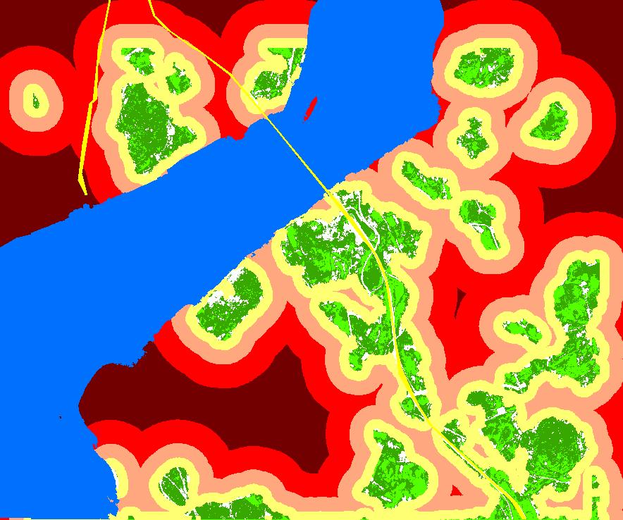
7 Physical vulnerability - Structural vulnerability Land cover Building classification height Urban structure Legend Central high dense built-up area Central dense built-up area Central dense built-up area Central loose dense built-up are Central open space Central open space Peripheral dense built-up area Peripheral high dense built-up Peripheral loose dense built-up Peripheral open space Peripheral open space Water unc lassified Folie 7
8 Components Cause Indicator / Variable R H A Z A R D Natural Hazard Natural disaster, Human Threat, Phenomenon Secondary hazards Time, Frequency, Magnitude, spatial exposure, Probability of occurence, Length of time Landslides, Tsunami, Fire I S K V U L N E R A B I L I T Y Physical Vulnerability Demographic Vulnerability Social Vulnerability Economic Vulnerability Structural vulnerability Location Infrastructure Natural Resources Population structure Population development Social status Accessibility of local facilities for supply Individual financial potential Governmental potential Urban structure, building density, building height, building material, building type, fragility of buildings, number of buildings Accessibility, inclination of surface, soil type, height information Street network, publich transport, communication, pipelines, supply units Water supply, agriculture, Land cover type Population density, day- and night time population, age structure, gender Population growth, migrations rate, urbanization Education, health, social network Hospital, school, fire brigade, emergency accomondation Per capita income, insurance, property, unemployment rate Gross national product, inflation, help organisations, Human Poverty Index (HPI) Political Vulnerability Decision structures Political system, early warning system, crisis

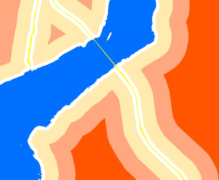


9 Physical Vulnerability - Location 1 meter 3 meter 5 meter
10 Components Cause Indicator / Variable R H A Z A R D Natural Hazard Natural disaster, Human Threat, Phenomenon Secondary hazards Time, Frequency, Magnitude, spatial exposure, Probability of occurence, Length of time Landslides, Tsunami, Fire I S K V U L N E R A B I L I T Y Physical Vulnerability Demographic Vulnerability Social Vulnerability Economic Vulnerability Structural vulnerability Location Infrastructure Natural Resources Population structure Population development Social status Accessibility of local facilities for supply Individual financial potential Governmental potential Urban structure, building density, building height, building material, building type, fragility of buildings, number of buildings Accessibility, inclination of surface, soil type, height information Street network, publich transport, communication, pipelines, supply units Water supply, agriculture, Land cover type Population density, day- and night time population, age structure, gender Population growth, migrations rate, urbanization Education, health, social network Hospital, school, fire brigade, emergency accomondation Per capita income, insurance, property, unemployment rate Gross national product, inflation, help organisations, Human Poverty Index (HPI) Political Vulnerability Decision structures Political system, early warning system, crisis


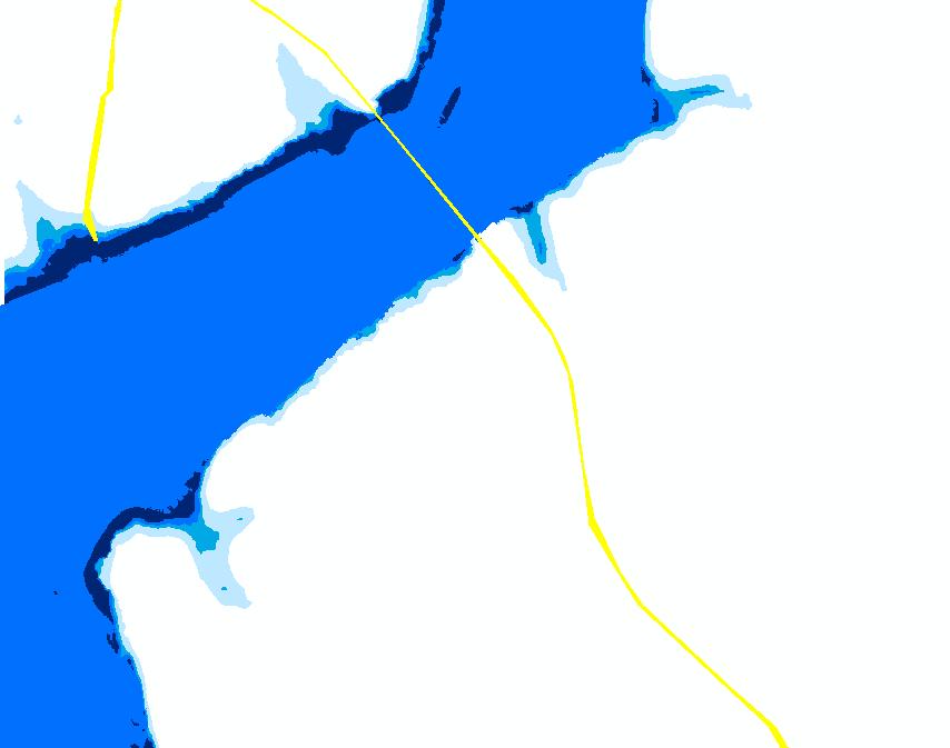
11 Demographic vulnerability Leg end Population_night Inh per km² Bo sp orus Folie 11


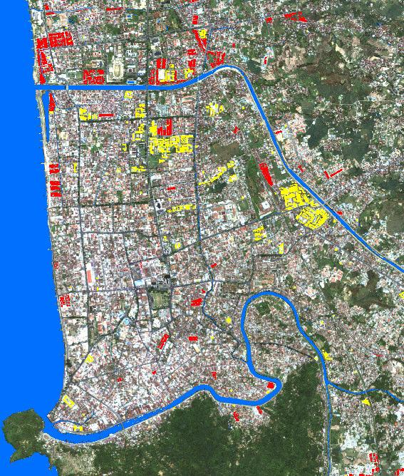
12 Urbanization in Istanbul Landsat ETM from 2000 Folie 12
13 Components Cause Indicator / Variable R H A Z A R D Natural Hazard Natural disaster, Human Threat, Phenomenon Secondary hazards Time, Frequency, Magnitude, spatial exposure, Probability of occurence, Length of time Landslides, Tsunami, Fire I S K V U L N E R A B I L I T Y Physical Vulnerability Demographic Vulnerability Social Vulnerability Economic Vulnerability Structural vulnerability Location Infrastructure Natural Resources Population structure Population development Social status Accessibility of local facilities for supply Individual financial potential Governmental potential Urban structure, building density, building height, building material, building type, fragility of buildings, number of buildings Accessibility, inclination of surface, soil type, height information Street network, publich transport, communication, pipelines, supply units Water supply, agriculture, Land cover type Population density, day- and night time population, age structure, gender Population growth, migrations rate, urbanization Education, health, social network Hospital, school, fire brigade, emergency accomondation Per capita income, insurance, property, unemployment rate Gross national product, inflation, help organisations, Human Poverty Index (HPI) Political Vulnerability Decision structures Political system, early warning system, crisis

14 Risk Hazard - Vulnerability Izmit Earthquake 1999 Folie 14
15 Interdisciplinary building assessment Land cover classification Spatial reference 100,0 80,0 Low building, flat roof, > 1975 Low building, pitched roof, > 1975 Medium high building, flat roof, > 1975 High building, pitched roof, > 1975 Building height Roof type Building age MDF [%] 60,0 40,0 MDF = Mean Damage Factor Type of construction Statistical parameter 20,0 0, minor damages damages strong damages destructive devastating catastrophe Intensity Folie 15

16 Structural vulnerability assessment Example Earthquake Scenario: Intensity 11 Folie 16


17 Land cover classification: Padang Legend Water Streets Buildings Grassland Trees Bare soil Sealed area Ikonos imagery, 2005 Folie 17


18 Folie 18
 Height 500 250 0")
19 Digital Elevation Model (DEM) Height Folie 19

20 Safe areas Legend 8 15 Meter Meter Meter > 25 Meter Water Excursion "Introduction to Geographical Remote Sensing, Folie 20 DLR Oberpfaffenhofen, Institut für Methodik der Fernerkundung January bzw. 25th Deutsches 2008 Fernerkundungsdatenzentrum

21 Inundation probability for 60 scenarios 100 % 50 % 25 % 10 % 5 % Folie 21


22 Evacuation t = 0 min t = 10 min t = 20 min Preliminary results: t = 30 min Total population: t = 40 min t = 20: ca in safe areas t = 50 min t = 60 min t = 70 min t = 80 min Folie 22
23 Accuracy assessment Location Processing type Istanbul, Turkey Automated object-oriented approach Padang, Indonesia Combination of digitization and automated classification Classes User Acc. [%] Prod. Acc[%] User Acc. [%] Prod. Acc[%] Houses 83,3 % 82,4 % 96,9 % 97,4 % Vegetation 84,2 % 86,4 % 95,1 % 94,4 % Streets 79,7 % 74,9 % 98,7 % 97,1 % Water 100 % 100 % 99,9 % 100 % Bare Soil 75,8 % 71,1 % 88,4 % 91,3 % Total 84,54 % 96,20 % Folie 23
24 Estimated Processing Effort for Mexico City Mexico City ~ 15 scenes IKONOS, 20 scenes Quickbird Processing effort of proposed procedure (automated) IKONOS ~ 4 days per scene => 60 working days Quickbird ~ 5 days per scene => 100 working days Processing effort of manual procedure (digitizing) Padang (GITEWS project) Mexico City 1 IKONOS scene objects (buildings and street network) 6 man months (MM) per scene IKONOS => 90 MM Quickbird => 120 MM Folie 24

25 Contribution of remote sensing data and methods to the risk and vulnerability framework How many people are at risk How many buildings are at risk What is their spatial distribution Where are safe areas How can we reach safe areas Spatial information as basis to recognize, anticipate, measure and understand risk and vulnerability Folie 25
26 Selected Literature: Taubenböck, H., Joachim Post, Ralph Kiefl, Achim Roth, Febrin, Günter Strunz, Stefan Dech (2008): Risk and vulnerability assessment to tsunami hazard using very high resolution satellite data. In: Proceedings of the EARSeL Joint Workshop: Remote Sensing: New Challenges of high resolution. (Eds., Carsten Jürgens). pp Bochum, Germany. Taubenböck, H., Roth, A., Dech, S. (2007): Linking structural urban characteristics derived from high resolution satellite data to population distribution. In: Urban and Regional Data Management. In: Coors, Rumor, Fendel & Zlatanova (Hrsg.). Taylor & Francis Group, London, ISBN S Esch, T. (2006): Automatisierte Analyse von siedlungsflächen auf der Basis höchstauflösender Radardaten. Bayerische Julius-Maximilian Universität. Dissertation. S Taubenböck, H., Habermeyer, M., Roth, A. and Dech, S.(2006): Automated allocation of highly-structured urban areas in homogeneous zones from remote sensing data by Savitzky-Golay Filtering and curve sketching. In: IEEE Geoscience and Remote Sensing Letters. Volume 3, Issue 4, pp ISSN X. Münich, J., Taubenböck, H., Stempniewski, L., Dech, S., Roth, A. (2006): Remote sensing and engineering: An interdisciplinary approach to assess vulnerability in urban areas, In: First European Conference on Earthquake Engineering and Seismology. Geneva, Switzerland. S.10. Esch, T., Roth, A. and Dech, S. W. (2005): Robust approach towards an automated detection of built-up areas from high resolution radar imagery. In: Proceedings of the ISPRS WG VII/1 Human Settlement and Impact Analysis, 3rd International Symposium on Remote Sensing and Data Fusion over Urban Areas (URBAN 2005) and 5th International Symposium on Remote Sensing on Urban Areas (URS 2005). Tempe, AZ, USA. CD-ROM. Thanks for your kind attention! Folie 26

27 Spatial vulnerability assessment Folie 27

28 Disaster risk circle Folie 28
1st EARSeL Workshop of the SIG Urban Remote Sensing Humboldt-Universität zu Berlin, 2-3 March 2006
 1 AN URBAN CLASSIFICATION APPROACH BASED ON AN OBJECT ORIENTED ANALYSIS OF HIGH RESOLUTION SATELLITE IMAGERY FOR A SPATIAL STRUCTURING WITHIN URBAN AREAS Hannes Taubenböck, Thomas Esch, Achim Roth German
Remote Sensing for Seismic Vulnerability Assessment of Built Environments
 www.dlr.de Folie 1/20 Remote Sensing for Seismic Vulnerability Assessment of Built Environments Christian Geiß, Joachim Post, Hannes Taubenböck et al. www.dlr.de Folie 2/20 Motivation - Rapid urbanization
Uses of free satellite imagery for Disaster Risk Reduction (DRR)
") Centre of Applied Geoscience, Disaster Risk Reduction Research Group, School of Earth and Environmental Science, University of Portsmouth, UK Uses of free satellite imagery for Disaster Risk Reduction
Centre of Applied Geoscience, Disaster Risk Reduction Research Group, School of Earth and Environmental Science, University of Portsmouth, UK Uses of free satellite imagery for Disaster Risk Reduction
2013 Esri Europe, Middle East and Africa User Conference October 23-25, 2013 Munich, Germany
 2013 Esri Europe, Middle East and Africa User Conference October 23-25, 2013 Munich, Germany Environmental and Disaster Management System in the Valles Altos Region in Carabobo / NW-Venezuela Prof.Dr.habil.Barbara
Georeferencing and Satellite Image Support: Lessons learned, Challenges and Opportunities
 Georeferencing and Satellite Image Support: Lessons learned, Challenges and Opportunities Shirish Ravan shirish.ravan@unoosa.org UN-SPIDER United Nations Office for Outer Space Affairs (UNOOSA) UN-SPIDER
Use of Geospatial data for disaster managements
 Use of Geospatial data for disaster managements Source: http://alertsystemsgroup.com Instructor : Professor Dr. Yuji Murayama Teaching Assistant : Manjula Ranagalage What is GIS? A powerful set of tools
Developing fragility functions for tsunami damage estimation using the numerical model and satellite imagery
 Developing fragility functions for tsunami damage estimation using the numerical model and satellite imagery Shunichi KOSHIMURA 1 and Hideaki YANAGISAWA 2 1 Associate Professor, Disaster Control Research
Advanced Image Analysis in Disaster Response
 Advanced Image Analysis in Disaster Response Creating Geographic Knowledge Thomas Harris ITT The information contained in this document pertains to software products and services that are subject to the
Copernicus Overview. Major Emergency Management Conference Athlone 2017
 Copernicus Overview Major Emergency Management Conference Athlone 2017 Copernicus is a European programme implemented by the European Commission. The services address six thematic areas: land, marine,
World Geography. WG.1.1 Explain Earth s grid system and be able to locate places using degrees of latitude and longitude.
 Standard 1: The World in Spatial Terms Students will use maps, globes, atlases, and grid-referenced technologies, such as remote sensing, Geographic Information Systems (GIS), and Global Positioning Systems
Introduction. Thematic Mapping for Disaster Risk Assessment in Case of Earthquake FIG Working Week
 Thematic Mapping for Disaster Risk Assessment in Case of Earthquake Silvia MARINOVA, Temenoujka BANDROVA, Mihaela KOUTEVA-GUENTCHEVA, Stefan BONCHEV University of Architecture, Civil Engineering and Geodesy
INDIANA ACADEMIC STANDARDS FOR SOCIAL STUDIES, WORLD GEOGRAPHY. PAGE(S) WHERE TAUGHT (If submission is not a book, cite appropriate location(s))
 WHERE TAUGHT (If submission is not a book, cite appropriate location(s))") Prentice Hall: The Cultural Landscape, An Introduction to Human Geography 2002 Indiana Academic Standards for Social Studies, World Geography (Grades 9-12) STANDARD 1: THE WORLD IN SPATIAL TERMS Students
Prentice Hall: The Cultural Landscape, An Introduction to Human Geography 2002 Indiana Academic Standards for Social Studies, World Geography (Grades 9-12) STANDARD 1: THE WORLD IN SPATIAL TERMS Students
Disaster Management & Recovery Framework: The Surveyors Response
 Disaster Management & Recovery Framework: The Surveyors Response Greg Scott Inter-Regional Advisor Global Geospatial Information Management United Nations Statistics Division Department of Economic and
Current Landscape of Spatial Decision Support Systems (SDSS) and Software Applications for Earthquake Disaster Management in Turkey
 and Software Applications for Earthquake Disaster Management in Turkey") Presented at the FIG Congress 2018, May 6-11, 2018 in Istanbul, Turkey Current Landscape of Spatial Decision Support Systems (SDSS) and Software Applications for Earthquake Disaster Management in Turkey
Presented at the FIG Congress 2018, May 6-11, 2018 in Istanbul, Turkey Current Landscape of Spatial Decision Support Systems (SDSS) and Software Applications for Earthquake Disaster Management in Turkey
FLOOD HAZARD AND RISK ASSESSMENT IN MID- EASTERN PART OF DHAKA, BANGLADESH
 FLOOD HAZARD AND RISK ASSESSMENT IN MID- EASTERN PART OF DHAKA, BANGLADESH Muhammad MASOOD MEE07180 Supervisor: Prof. Kuniyoshi TAKEUCHI ABSTRACT An inundation simulation has been done for the mid-eastern
Summary of Available Datasets that are Relevant to Flood Risk Characterization
 Inter-Agency Characterization Workshop February 25-27, 2014 USACE Institute for Water Resources, Alexandria, VA, IWR Classroom Summary of Available Datasets that are Relevant to Characterization National
National Disaster Management Centre (NDMC) Republic of Maldives. Location
 Republic of Maldives. Location") National Disaster Management Centre (NDMC) Republic of Maldives Location Country Profile 1,190 islands. 198 Inhabited Islands. Total land area 300 sq km Islands range b/w 0.2 5 sq km Population approx.
National Disaster Management Centre (NDMC) Republic of Maldives Location Country Profile 1,190 islands. 198 Inhabited Islands. Total land area 300 sq km Islands range b/w 0.2 5 sq km Population approx.
REMOTE SENSING FOR MEGACITIES RESEARCH
 1st EARSeL Workshop of the SIG Urban Remote Sensing 1 REMOTE SENSING FOR MEGACITIES RESEARCH Maik Netzband 1, Ellen Banzhaf 1 and Ulrike Weiland 1 1. Center for Environmental Research Leipzig-Halle GmbH,
DAMAGE DETECTION OF THE 2008 SICHUAN, CHINA EARTHQUAKE FROM ALOS OPTICAL IMAGES
 DAMAGE DETECTION OF THE 2008 SICHUAN, CHINA EARTHQUAKE FROM ALOS OPTICAL IMAGES Wen Liu, Fumio Yamazaki Department of Urban Environment Systems, Graduate School of Engineering, Chiba University, 1-33,
Earthquake Hazard Analysis Methods: A Review
 IOP Conference Series: Earth and Environmental Science PAPER OPEN ACCESS Earthquake Hazard Analysis Methods: A Review To cite this article: A M Sari and A Fakhrurrozi 2018 IOP Conf. Ser.: Earth Environ.
Building Disaster Resilience Community in Asia: Indonesian perspective
 Workshop C of the 7th Science Council of Asia (SCA) Conference Construction of Secure and Safe Society against Global Changes of Natural Disasters Okinawa, June 14 th, 2007 Building Disaster Resilience
The UN-GGIM: Europe core data initiative to encourage Geographic information supporting Sustainable Development Goals Dominique Laurent, France
 INSPIRE conference Strasbourg 6 September 2017 The UN-GGIM: Europe core data initiative to encourage Geographic information supporting Sustainable Development Goals Dominique Laurent, France Introduction
World Meteorological Organization
 World Meteorological Organization Opportunities and Challenges for Development of Weather-based Insurance and Derivatives Markets in Developing Countries By Maryam Golnaraghi, Ph.D. Head of WMO Disaster
AUTOMATED BUILDING DETECTION FROM HIGH-RESOLUTION SATELLITE IMAGE FOR UPDATING GIS BUILDING INVENTORY DATA
 13th World Conference on Earthquake Engineering Vancouver, B.C., Canada August 1-6, 2004 Paper No. 678 AUTOMATED BUILDING DETECTION FROM HIGH-RESOLUTION SATELLITE IMAGE FOR UPDATING GIS BUILDING INVENTORY
Pacific Catastrophe Risk Assessment And Financing Initiative
 Pacific Catastrophe Risk Assessment And Financing Initiative VANUATU September 211 Country Risk Profile: VANUATU is expected to incur, on average, 48 million USD per year in losses due to earthquakes and
J M MIRANDA UNIVERSITY OF LISBON THE USE OF REMOTE SENSING FOR EARTHQUAKE RISK ASSESSMENT AND MITIGATION
 1 THE USE OF REMOTE SENSING FOR EARTHQUAKE RISK ASSESSMENT AND MITIGATION 2 the observation of strong ground motion and aftershock sequences as well as the investigation of the destruction from these earthquakes
Remote Sensing the Urban Landscape
 Remote Sensing the Urban Landscape Urban landscape are composed of a diverse assemblage of materials (concrete, asphalt, metal, plastic, shingles, glass, water, grass, shrubbery, trees, and soil) arranged
Foundation Geospatial Information to serve National and Global Priorities
 Foundation Geospatial Information to serve National and Global Priorities Greg Scott Inter-Regional Advisor Global Geospatial Information Management United Nations Statistics Division UN-GGIM: A global
LARGE-SCALE INDUSTRIAL SITE SELECTION USING A MINIMUM NATURAL RISK APPROACH CONCEPT AND PROTOTYPIC IMPLEMENTATION. Master Thesis Defence Anne Birckigt
 LARGE-SCALE INDUSTRIAL SITE SELECTION USING A MINIMUM NATURAL RISK APPROACH CONCEPT AND PROTOTYPIC IMPLEMENTATION Master Thesis Defence Anne Birckigt Dresden, Dresden, 23.09.2011 Outline 1. Motivation
Introduction to GIS. Dr. M.S. Ganesh Prasad
 Introduction to GIS Dr. M.S. Ganesh Prasad Department of Civil Engineering The National Institute of Engineering, MYSORE ganeshprasad.nie@gmail.com 9449153758 Geographic Information System (GIS) Information
Geography General Course Year 12. Selected Unit 3 syllabus content for the. Externally set task 2019
 Geography General Course Year 12 Selected Unit 3 syllabus content for the Externally set task 2019 This document is an extract from the Geography General Course Year 12 syllabus, featuring all of the content
SDG s and the role of Earth Observation
 SDG s and the role of Earth Observation Christian Heipke IPI - Institute for Photogrammetry and GeoInformation Leibniz Universität Hannover Germany Secretary General, ISPRS 1. No Poverty 2. Zero Hunger
Meeting the Challenges of Earthquake Risk Dynamics and Globalisation
 Check Against Delivery. Embargoed until 4:15 PM, 5 November 2010 Meeting the Challenges of Earthquake Risk Dynamics and Globalisation by Jochen Zschau GFZ German Research Centre for Geosciences, Potsdam,
SUPPORTS SUSTAINABLE GROWTH
 DDSS BBUUN NDDLLEE G E O S P AT I A L G O V E R N A N C E P A C K A G E SUPPORTS SUSTAINABLE GROWTH www.digitalglobe.com BRISBANE, AUSTRALIA WORLDVIEW-3 30 CM International Civil Government Programs US
The AIR Bushfire Model for Australia
 The AIR Bushfire Model for Australia In February 2009, amid tripledigit temperatures and drought conditions, fires broke out just north of Melbourne, Australia. Propelled by high winds, as many as 400
DOWNLOAD OR READ : GIS BASED FLOOD LOSS ESTIMATION MODELING IN JAPAN PDF EBOOK EPUB MOBI
 DOWNLOAD OR READ : GIS BASED FLOOD LOSS ESTIMATION MODELING IN JAPAN PDF EBOOK EPUB MOBI Page 1 Page 2 gis based flood loss estimation modeling in japan gis based flood loss pdf gis based flood loss estimation
EXPLORING THE DEMANDS ON HYPERSPECTRAL DATA PRODUCTS FOR URBAN PLANNING: A CASE STUDY IN THE MUNICH REGION
 EXPLORING THE DEMANDS ON HYPERSPECTRAL DATA PRODUCTS FOR URBAN PLANNING: A CASE STUDY IN THE MUNICH REGION W.Heldens 1, T. Esch 2, U. Heiden 2, A. Müller 2 and S. Dech 1,2 1 Department of Remote Sensing,
THE STUDY ON 4S TECHNOLOGY IN THE COMMAND OF EARTHQUAKE DISASTER EMERGENCY 1
 THE STUDY ON 4S TECHNOLOGY IN THE COMMAND OF EARTHQUAKE DISASTER EMERGENCY 1 Zhou Wensheng 1, Huang Jianxi 2, Li Qiang 3, Liu Ze 3 1 Associate Professor, School of Architecture, Tsinghua University, Beijing.
Geospatial Information Management in the Americas: Lessons for the Post-2015 development agenda
 Geospatial Information Management in the Americas: Lessons for the Post-2015 development agenda Rolando Ocampo President, UN-GGIM: Americas October 2014 The integration of statistical and geographical
Pacific Catastrophe Risk Assessment And Financing Initiative
 Pacific Catastrophe Risk Assessment And Financing Initiative PALAU September is expected to incur, on average,.7 million USD per year in losses due to earthquakes and tropical cyclones. In the next 5 years,
UGRC 144 Science and Technology in Our Lives/Geohazards
 UGRC 144 Science and Technology in Our Lives/Geohazards Session 1 Introduction to Hazards and Disasters Dr. Patrick Asamoah Sakyi Department of Earth Science, UG, Legon College of Education School of Continuing
Integrated Approach to Assess the Impact of Tsunami Disaster
 Integrated Approach to Assess the Impact of Tsunami Disaster Shunichi Koshimura & Shintaro Kayaba Disaster Control Research Center, Graduate School of Engineering, Tohoku University, Japan Masashi Matsuoka
MULTI-HAZARD RISK ASSESSMENT AND DECISION MAKING
 MULTI-HAZARD RISK ASSESSMENT AND DECISION MAKING JULINDA KEÇI Epoka University Logo of the institution CONTENT: Introduction Multi Hazard Risks Multi-Hazard Risk Assessment Quantitative Assessment Event
They include earthquakes, volcanic eruptions, floods, landslides, and other processes and occurrences. They are included in the broader concept of.
 They include earthquakes, volcanic eruptions, floods, landslides, and other processes and occurrences. They are included in the broader concept of. In general, natural processes are labeled hazardous only
GIS and Remote Sensing Support for Evacuation Analysis
 GIS and Remote Sensing Support for Evacuation Analysis Presented to GIS for Transportation Symposium Rapid City, South Dakota March 28-31, 2004 Demin Xiong Oak Ridge National Laboratory 2360 Cherahala
Status after Six Years
 German-Indonesian Tsunami Early Warning System () Status after Six Years Joern Lauterjung and the -Team Challenge Indonesia Short Early Warning Time Tsunamis are generated at the trench (orange line) Traveltimes
Disaster Risk Assessment: Opportunities for GIS and data management with Open DRI
 Disaster Risk Assessment: Opportunities for GIS and data management with Open DRI Jacob Opadeyi Department of Geomatics Engineering and Land Management, The University of the West Indies, St. Augustine,
Remote Sensing and GIS Contribution to. Tsunami Risk Sites Detection. of Coastal Areas in the Mediterranean
 The Third International Conference on Early Warning (EWC III), 26.-29.March 2006 in Bonn Remote Sensing and GIS Contribution to Tsunami Risk Sites Detection of Coastal Areas in the Mediterranean BARBARA
Determination of flood risks in the yeniçiftlik stream basin by using remote sensing and GIS techniques
 Determination of flood risks in the yeniçiftlik stream basin by using remote sensing and GIS techniques İrfan Akar University of Atatürk, Institute of Social Sciences, Erzurum, Turkey D. Maktav & C. Uysal
GIS methodologies for local tsunami risk assessment: examples
 GIS methodologies for local tsunami risk assessment: examples R. Frauenfelder 1,2, C.B. Harbitz 1,2, Sverdrup-Thygeson 1,2, G. Kaiser 2,4, R. Swarny 3, L. Gruenburg 3, S. Glimsdal 1,2, F. Løvholt 1,2,
COMPREHENSIVE GIS-BASED SOLUTION FOR ROAD BLOCKAGE DUE TO SEISMIC BUILDING COLLAPSE IN TEHRAN
 COMPREHENSIVE GIS-BASED SOLUTION FOR ROAD BLOCKAGE DUE TO SEISMIC BUILDING COLLAPSE IN TEHRAN B. Mansouri 1, R. Nourjou 2 and K.A. Hosseini 3 1 Assistant Professor, Dept. of Emergency Management, International
Interpretive Map Series 24
 Oregon Department of Geology and Mineral Industries Interpretive Map Series 24 Geologic Hazards, and Hazard Maps, and Future Damage Estimates for Six Counties in the Mid/Southern Willamette Valley Including
Initiative. Country Risk Profile: papua new guinea. Better Risk Information for Smarter Investments PAPUA NEW GUINEA.
 Pacific Catastrophe Risk Assessment And Financing Initiative PAPUA NEW GUINEA September 211 Country Risk Profile: papua new is expected to incur, on average, 85 million USD per year in losses due to earthquakes
Pacific Catastrophe Risk Assessment And Financing Initiative
 Pacific Catastrophe Risk Assessment And Financing Initiative TIMOR-LESTE September Timor-Leste is expected to incur, on average, 5.9 million USD per year in losses due to earthquakes and tropical cyclones.
Pacific Catastrophe Risk Assessment And Financing Initiative
 Pacific Catastrophe Risk Assessment And Financing Initiative TUVALU is expected to incur, on average,. million USD per year in losses due to earthquakes and tropical cyclones. In the next 5 years, has
FLOOD HAZARD MAPPING OF DHAKA-NARAYANGANJ-DEMRA (DND) PROJECT USING GEO-INFORMATICS TOOLS
 PROJECT USING GEO-INFORMATICS TOOLS") FLOOD HAZARD MAPPING OF DHAKA-NARAYANGANJ-DEMRA (DND) PROJECT USING GEO-INFORMATICS TOOLS Md. Aminul Islam MEE07178 Supervisor: Prof. Kuniyoshi TAKEUCHI ABSTRACT Dhaka-Narayanganj-Demra (DND) Project is
FLOOD HAZARD MAPPING OF DHAKA-NARAYANGANJ-DEMRA (DND) PROJECT USING GEO-INFORMATICS TOOLS Md. Aminul Islam MEE07178 Supervisor: Prof. Kuniyoshi TAKEUCHI ABSTRACT Dhaka-Narayanganj-Demra (DND) Project is
RiskCity Training package on the Application of GIS for multi- hazard risk assessment in an urban environment.
 RiskCity Training package on the Application of GIS for multi- hazard risk assessment in an urban environment. Cees van Westen (Westen@itc.nl) & Nanette C. Kingma (Kingma@itc.nl) ITC: Training & Research
Global Atmospheric Circulation. Past climate change and natural causes. Global climate change and human activity
 GCSE Geography Edexcel B Revision Checklist Paper 1. Global Geographical Issues Topic 1. Hazardous Earth Key Idea I know/ understand The world s climate system Global Atmospheric Circulation Past climate
Academic Vocabulary CONTENT BUILDER FOR THE PLC WORLD GEOGRAPHY
 Academic Vocabulary CONTENT BUILDER FOR THE PLC WORLD GEOGRAPHY : academic vocabulary directly taken from the standard STANDARD WG.1A analyze the effects of physical and human geographic patterns and processes
Report of the Working Group 2 Data Sharing and Integration for Disaster Management *
 UNITED NATIONS E/CONF.104/6 ECONOMIC AND SOCIAL COUNCIL Twentieth United Nations Regional Cartographic Conference for Asia and the Pacific Jeju, 6-9 October 2015 Item 5 of the provisional agenda Report
COASTAL FLOOD RISK MODELING TOOL (Preliminary assessment of impact of climate change in north Jakarta coastal area)
") COASTAL FLOOD RISK MODELING TOOL (Preliminary assessment of impact of climate change in north Jakarta coastal area) Prof. Dr. rer.nat. Muh Aris Marfai, M.Sc Dr. Philip Ward Workshop-Seminar Jakarta Climate
COASTAL FLOOD RISK MODELING TOOL (Preliminary assessment of impact of climate change in north Jakarta coastal area) Prof. Dr. rer.nat. Muh Aris Marfai, M.Sc Dr. Philip Ward Workshop-Seminar Jakarta Climate
Development of an urban classification method using a built-up index
 Development of an urban classification method using a built-up index JIN A LEE, SUNG SOON LEE, KWANG HOON CHI Dep.Geoinformatic Engineering, University of Science & Technology Dep. Geoscience Information,
Risk-based land use and spatial planning
 Risk-based land use and spatial planning Miho OHARA International Centre for Water Hazards and Risk Management (ICHARM) Public Works Research Institute PWRI), Japan Under the auspices of UNESCO Introduction
Earthquake Emergency Preparedness in Central-Hungary
 UN-SPIDER Fourth United Nations International UN-SPIDER Bonn Workshop on Disaster Management and Space Technology: The 4C Challenge:Communication Coordination Cooperation Capacity Development Bonn, Germany,
Enquiry question: How does the world s climate system function, why does it change and how can this be hazardous for people?
 Content Topic 1: Hazardous Earth Enquiry question: How does the world s climate system function, why does it change and how can this be hazardous for people? 1.1 The atmosphere operates as a global system
We greatly appreciate the review of the manuscript by the anonymous referee#3. We hereby put forth the clarifications as follows.
 Point by point response to the observations & comments of Anonymous Reviewer # 3 on the manuscript titled Seismic Vulnerability & Risk Assessment of Kolkata City, India (ms# nhess-2013-467) We greatly
3D BUILDING GIS DATABASE GENERATION FROM LIDAR DATA AND FREE ONLINE WEB MAPS AND ITS APPLICATION FOR FLOOD HAZARD EXPOSURE ASSESSMENT
 3D BUILDING GIS DATABASE GENERATION FROM LIDAR DATA AND FREE ONLINE WEB MAPS AND ITS APPLICATION FOR FLOOD HAZARD EXPOSURE ASSESSMENT Jojene R. Santillan, Meriam Makinano-Santillan, Linbert C. Cutamora,
Source:
 Source: http://www.pastforward.ca/perspectives/columns/10_02_05.htm At 16:53, on Wednesday, January 12th, 2010, a devastating 7.0 earthquake struck Haiti's capital, Port-au-Prince. The earthquake left
Baldwin County, Alabama
 2015 Baldwin County, Alabama Multi-Hazard Mitigation Plan I. Comprehensive Plan A multi-jurisdiction plan City of Bay Minette City of Daphne Town of Elberta City of Fairhope City of Foley City of Gulf
Jeopardy. Final Jeopardy $100 $100 $100 $100 $100 $200 $200 $200 $200 $200 $300 $300 $300 $300 $400 $400 $400 $500 $500 $500 $500 $500
 Jeopardy Earthquakes Volcanoes Tsunamis Wildfires Landslides/ Droughts $100 $100 $100 $100 $100 $200 $200 $200 $200 $200 $300 $300 $300 $300 $300 $400 $400 $400 $400 $400 $500 $500 $500 $500 $500 Final
GIS = Geographic Information Systems;
 What is GIS GIS = Geographic Information Systems; What Information are we talking about? Information about anything that has a place (e.g. locations of features, address of people) on Earth s surface,
Word Cards. 2 map. 1 geographic representation. a description or portrayal of the Earth or parts of the Earth. a visual representation of an area
 Name: Date: Hour: Word Cards 1 geographic representation a description or portrayal of the Earth or parts of the Earth Example: A map is a representation of an actual location or place. 2 map a visual
Joint Research Centre (JRC)
") Joint Research Centre (JRC) IPSC - Institute for the Protection and Security of the Citizen SES - Support to External Security Unit Ispra Italy http://isferea.jrc.ec.europa.eu/ http://www.jrc.ec.europa.eu/
Joint Research Centre (JRC) IPSC - Institute for the Protection and Security of the Citizen SES - Support to External Security Unit Ispra Italy http://isferea.jrc.ec.europa.eu/ http://www.jrc.ec.europa.eu/
Lesson 8. Natural Disasters
 Lesson 8 Natural Disasters 1 Reading is NOT a spectator sport! 2 Reading requires active participation! 3 PREDICT Try to figure out what information will come next and how the selection might end. 4 Natural
Wainui Beach Management Strategy (WBMS) Summary of Existing Documents. GNS Tsunami Reports
 Summary of Existing Documents. GNS Tsunami Reports") Wainui Beach Management Strategy (WBMS) Summary of Existing Documents GNS Tsunami Reports a) Review of Tsunami Hazard and Risk in New Zealand ( National Risk Report ) b) Review of New Zealand s Preparedness
Wainui Beach Management Strategy (WBMS) Summary of Existing Documents GNS Tsunami Reports a) Review of Tsunami Hazard and Risk in New Zealand ( National Risk Report ) b) Review of New Zealand s Preparedness
Potential Open Space Detection and Decision Support for Urban Planning by Means of Optical VHR Satellite Imagery
 Remote Sensing and Geoinformation Lena Halounová, Editor not only for Scientific Cooperation EARSeL, 2011 Potential Open Space Detection and Decision Support for Urban Planning by Means of Optical VHR
Disaster Prevention and Management in Asia: The Context of Human Security and Its Relevance to Infrastructure Planning and Management
 Disaster Prevention and Management in Asia: The Context of Human Security and Its Relevance to Infrastructure Planning and Management Rajib Shaw http://www.iedm.ges.kyoto-u.ac.jp/ Contents Background and
GIS and Remote Sensing
 Spring School Land use and the vulnerability of socio-ecosystems to climate change: remote sensing and modelling techniques GIS and Remote Sensing Katerina Tzavella Project Researcher PhD candidate Technology
Copernicus Overview and Emergency Management Service
 Copernicus Overview and Emergency Management Service Frédéric BASTIDE European Commission Open informal session of the United Nations Inter-Agency Meeting on Outer Space Activities 12 March 2013, Geneva
EMERGENCY PLANNING IN NORTHERN ALGERIA BASED ON REMOTE SENSING DATA IN RESPECT TO TSUNAMI HAZARD PREPAREDNESS
 EMERGENCY PLANNING IN NORTHERN ALGERIA BASED ON REMOTE SENSING DATA IN RESPECT TO TSUNAMI HAZARD PREPAREDNESS Barbara Theilen-Willige Technical University of Berlin, Institute of Applied Geosciences Department
SCENARIO DESIGN ON THE IMPACT OF A HIGH-MAGNITUDE EARTHQUAKE IN THE CITY OF LIMA, PERU
 SCENARIO DESIGN ON THE IMPACT EARTHQUAKE IN THE CITY OF LIMA, Methodology Determination of the characteristics of the probable earthquake (magnitude, intensity, acceleration). Seismic geotechnical soil
Globally Estimating the Population Characteristics of Small Geographic Areas. Tom Fitzwater
 Globally Estimating the Population Characteristics of Small Geographic Areas Tom Fitzwater U.S. Census Bureau Population Division What we know 2 Where do people live? Difficult to measure and quantify.
Application of a GIS for Earthquake Hazard Assessment and Risk Mitigation in Vietnam
 Application of a GIS for Earthquake Hazard Assessment and Risk Mitigation in Vietnam Nguyen Hong Phuong Earthquake Information and Tsunami Warning Centre, VAST OUTLINE Introduction Fault Source Model and
SEISMIC RISK ASSESSMENT IN ARMENIA
 SEISMIC RISK ASSESSMENT IN ARMENIA Hovhannes Khangeldyan Head of National Crisis Management Center Rescue Service Ministry of Emergency Situations of the Republic of Armenia Tokyo, 2016 ARMENIA: GEOGRAPHICAL
ACCURACY ASSESSMENT OF ASTER GLOBAL DEM OVER TURKEY
 ACCURACY ASSESSMENT OF ASTER GLOBAL DEM OVER TURKEY E. Sertel a a ITU, Civil Engineering Faculty, Geomatic Engineering Department, 34469 Maslak Istanbul, Turkey sertele@itu.edu.tr Commission IV, WG IV/6
I&CLC2000 in support to new policy initiatives (INSPIRE, GMES,..)
") I&CLC2000 in support to new policy initiatives (INSPIRE, GMES,..) Manfred Grasserbauer, Director Joint Research Centre Institute for Environment and Sustainability 1 IMAGE 2000 European mosaic of satellite
I&CLC2000 in support to new policy initiatives (INSPIRE, GMES,..) Manfred Grasserbauer, Director Joint Research Centre Institute for Environment and Sustainability 1 IMAGE 2000 European mosaic of satellite
Status & Challengers of Cook Islands GEO DRM. Cook Islands GEO S/GIS History
 Status & Challengers of Cook Islands GEO DRM By Patrick A. ARIOKA Planning & Advisory Officer EMERGENCY MANAGEMENT COOK ISLANDS Cook Islands GEO S/GIS History 1990 NZODA/MFAT trained by Landcare Research
FIG Congress 2014 Engaging the Challenges, Enhancing the Relevance Kuala Lumpur, Malaysia, June 2014
 FIG Congress 2014 Engaging the Challenges, Enhancing the Relevance Kuala Lumpur, Malaysia, 16 21 June 2014 Disaster Risk Maps for Gender Empowerment in Disaster Management Lalitya Narieswari, Sri Lestari
Sustainable and Harmonised Development for Smart Cities The Role of Geospatial Reference Data. Peter Creuzer
 Sustainable and Harmonised Development for Smart Cities The Role of Geospatial Reference Data Peter Creuzer 1. Introduction - Smart Cities and Geodata 2. Geodata in Germany 3. Examples 4. Data and Service
Liana Talaue McManus. Division of Marine Affairs and Policy Rosenstiel School of Marine & Atmospheric Science University of Miami
 Liana Talaue McManus Division of Marine Affairs and Policy Rosenstiel School of Marine & Atmospheric Science University of Miami Outline 1. Coasts as vulnerable & resilient social ecological systems 2.
Kimberly J. Mueller Risk Management Solutions, Newark, CA. Dr. Auguste Boissonade Risk Management Solutions, Newark, CA
 1.3 The Utility of Surface Roughness Datasets in the Modeling of United States Hurricane Property Losses Kimberly J. Mueller Risk Management Solutions, Newark, CA Dr. Auguste Boissonade Risk Management
Floodplain Modeling and Mapping Using The Geographical Information Systems (GIS) and Hec-RAS/Hec-GeoRAS Applications. Case of Edirne, Turkey.
 and Hec-RAS/Hec-GeoRAS Applications. Case of Edirne, Turkey.") Floodplain Modeling and Mapping Using The Geographical Information Systems (GIS) and Hec-RAS/Hec-GeoRAS Applications. Case of Edirne, Turkey. Fuad Hajibayov *1, Basak Demires Ozkul 1, Fatih Terzi 1 1 Istanbul
Floodplain Modeling and Mapping Using The Geographical Information Systems (GIS) and Hec-RAS/Hec-GeoRAS Applications. Case of Edirne, Turkey. Fuad Hajibayov *1, Basak Demires Ozkul 1, Fatih Terzi 1 1 Istanbul
Predicting Tsunami Inundated Area and Evacuation Road Based On Local Condition Using GIS
 IOSR Journal of Environmental Science, Toxicology and Food Technology (IOSR-JESTFT) ISSN: 2319-2402, ISBN: 2319-2399. Volume 1, Issue 4 (Sep-Oct. 2012), PP 05-11 Predicting Tsunami Inundated Area and Evacuation
Challenges in data management during disasters
 Challenges in data management during disasters Sisi Zlatanova Associate Professor section GIST technology Leader Theme Group Geo-information for Crisis management OTB Research Institute for the built Environment
sentinel-2 COLOUR VISION FOR COPERNICUS
 sentinel-2 COLOUR VISION FOR COPERNICUS SATELLITES TO SERVE By providing a set of key information services for a wide range of practical applications, Europe s Copernicus programme is providing a step
Perception of Earthquake Risk and Postdisaster
 Perception of Earthquake Risk and Postdisaster Reconstruction: Comparative Study of Two Residential Neighborhoods on Different Socio-economic Status in Tehran Seyed Ali Badri University of Tehran, sabadri@ut.ac.ir
THE 3D SIMULATION INFORMATION SYSTEM FOR ASSESSING THE FLOODING LOST IN KEELUNG RIVER BASIN
 THE 3D SIMULATION INFORMATION SYSTEM FOR ASSESSING THE FLOODING LOST IN KEELUNG RIVER BASIN Kuo-Chung Wen *, Tsung-Hsing Huang ** * Associate Professor, Chinese Culture University, Taipei **Master, Chinese
Crisis Support and Disaster Response. in Latin America and the Caribbean
 Crisis Support and Disaster Response in Latin America and the Caribbean The Pan American Agenda 2010-2020 of the Pan American Institute of Geography and History (PAIGH), and the resulting 2010 Implementation
Contents. Introduction Study area Data and Methodology Results Conclusions
 Modelling Spatial Changes in Suburban Areas of Istanbul Using Landsat 5 TM Data Şinasi Kaya(Assoc. Prof. Dr. ITU) Elif Sertel(Assoc. Prof. Dr. ITU) Dursun Z. Şeker(Prof. Dr. ITU) 1 Contents Introduction
Measuring Disaster Risk for Urban areas in Asia-Pacific
 Measuring Disaster Risk for Urban areas in Asia-Pacific Acknowledgement: Trevor Clifford, Intl Consultant 1 SDG 11 Make cities and human settlements inclusive, safe, resilient and sustainable 11.1: By