GIS methodologies for local tsunami risk assessment: examples
|
|
|
- Leona Lloyd
- 5 years ago
- Views:
Transcription


1 GIS methodologies for local tsunami risk assessment: examples R. Frauenfelder 1,2, C.B. Harbitz 1,2, Sverdrup-Thygeson 1,2, G. Kaiser 2,4, R. Swarny 3, L. Gruenburg 3, S. Glimsdal 1,2, F. Løvholt 1,2, B. McAdoo 3 1 Norwegian Geotechnical Institute, Norway 2 International Centre for Geohazards, Norway 3 Department of Earth Sciences and Geography, Vassar College, Poughkeepsie, NY 4 Previously: Christian-Albrechts University of Kiel, Germany CONCERT-Japan Resilience Against Disasters NGI
2 Background and motivation Three tsunami vulnerability and risk analyses performed. GIS model being adapted to the available information. 1. Bridgetown, Barbados: possible future tsunami scenario, much information available Topography, population from local partners Field survey for building use and vulnerability 2. Batangas, The Philippines: possible future scenario, little information available Internet and other sources of information 3. American Samoa: hindcast of 2009 South Pacific tsunami for validation of the tsunami vulnerability and risk model


3 Methodology Bridgetown, Barbados Intentions: Develop methodology Demonstration study for local partners in a UWI/NGI capacity building programme Caribbean Sea Caribbean Sea
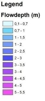
4 SITE DEPENDENT GENERAL Tsunami risk assessment Risk = Hazard * Consequence Hazard = maximum tsunami flow depth related to a certain probability of occurrence Consequence described by exposure and mortality Exposure; density of population Mortality; function of flow depth and building vulnerability 4 factors describing the buildings: height material barrier use
5 Structural building vulnerability Total structural building vulnerability was assessed using field survey data and their spatial extrapolation to bigger units Height code Height Vulnerability Description 1 4 Only one floor floors or more floors Use code Use Vulnerability Description 1 1 Residential/community service 2 3 Business/Commercial 3 4 Tourism Material code Material Vulnerability Description 1 2 Stone 2 4 Wood or timber 3 3 Wood + concrete 4 1 Concrete 5 2 Metal 6 3 stone and wood 7 Barrier code 2 Barrier Vulnerability concrete/metal Description 1 4 No barrier 8 3 concrete/stone/glasslow/narrow earth 2 3 embankment 3 2 Low concrete wall 4 1 High concrete wall 5 2 Low stone wall 6 1 High stone wall Heritage Sites Government Services (Health, Education, Fisheries, transportation etc) Emergency Services (Police, Fire, Coast Guard, EMS, medical etc) Community facilities (e.g. churches, community centers, recreational areas) Utilities (water, electricity, sewage, telecommunications, fuel, gas stations) 9 5 Banking and finance 10 0 Abandoned Credit: Nadia Gour, UWI
6 Total predicted mortality Convert all building vulnerability scores to 0,1 Use vulnerability score to pick the correct S-curve. 0.8 Example: 10 m flow depth- S-curve returns M 0.2,0.8 Norm. build. vuln. score = 0.4 Mortality = x ( ) = 0.44 Number of deaths = 0.44 x (population in cell) m


7 Local mortality risk Bridgetown, Barbados Hazard = Flow depth


8 Methodology Batangas City, The Philippines Intentions: Apply Bridgetown methodology in different study area Local demonstration project Challenge: Limited amount of data from local partners Therefore, everything was searched on the internet or studied from the sky, i.e. from google maps and a purchased Quickbird image


9 Structural building vulnerability Total structural building vulnerability was assessed using publicly available photographic imagery available on GE ID Assigned Vulnerability Description 1 0,25 concrete-stone, several floors 2 0,5 concrete-stone-wood, one or two floors 3 0,75 stone-wood, one or two floors 4 1 wood-corrugated iron, one floor 5 0,25 Large industrial plants Image credit: GoogleEarth, users: batangas, Romeo E. Barcena, samuel006, Teban


10 Local mortality risk Batangas

11 Hindcast of 2009 South Pacific tsunami for American Samoa Intentions: Validating the GIS model approach for building vulnerability and mortality American Samoa Maximum flow depth was obtained by back calculating the 2009 South Pacific earthquake and tsunami, A lot of data on population, building types, infrastructure, inundation, flow depth, damages, and death tolls The GIS model was adapted for optimal use of the available data
")


12 Comparison to trimlines ( v7 ) Leone Pago Pago Buildings and infrastructure not included in the simulations (may reduce the run-up)
13 Concluding remarks Method for quantitative tsunami risk assessment developed Flexibility with regard to amount and type of data at hand Two assessments + 1 validation successfully performed Potential for further development (distribution of people night/day, indoors/streets/public areas, importance of TEWS )
14 First deliverable to Rapsodi Publication in peer-reviewed journal about the three studies in Bridgetown, Batangas and Samoa, comparison of similarities and differences (WP1, D.1) Further work within Rapsodi Apply modified tsunami risk assessment for 2011 Tohoku event (WP4, D.8) Collaboration with PARI necessary Data, location, focus?
15 Quantitative tsunami risk assessment Our suggestion: to use extended tsunami risk model used at NGI extension could include: Specification of people exposure according to different scenarios Inclusion of economical values of private building and companies Accounting for environmental impacts and socio-economical interrelations (e.g. loss of ecosystem services) Inclusion of risk to lifelines (such as railway networks or social facilities)
16 General data interests High resolution (better than SRTM) digital elevation model Alternatively, digital contour line maps Census data aggregated by geographical units (enumeration districts, city quarters, etc.), the smaller the aggregation units, the better Data on structural building vulnerability (material, height, barriers)
17 General data interests Information on: Location of shelters Location of mitigation measures (evacuation plans and routes, safe elevated areas, barriers, etc.) Age of population (distribution) Differences in seasonal (residents?, seasonal workers?, tourism?) and/or night and day use of specific buildings, traffic routes, etc. -> Scenariobased distribution of people
18 Specific data interests (depending on final focus) Ecological focus: Land use/land cover map Value of ecosystems services/functions Location of industrial sites with potential for harm Economical focus: Property values (from statistics, GDP, number of employees, etc.) Critical infrastructure focus: Location of critical infrastructure, shelters, lifelines,

19 Thank you for your attention! Information from: N. Gour, H. Fritz, B. Jaffe, Shona v Z de Jong, S. Koshimura, J. Melby USGS EERI report American Samoa Department of Homeland Security Much more downloaded from internet Funding by: NGI/ICG/The Research Council of Norway US National Science Foundation (RAPID, PIRE) Vassar College
National Disaster Management Centre (NDMC) Republic of Maldives. Location
 Republic of Maldives. Location") National Disaster Management Centre (NDMC) Republic of Maldives Location Country Profile 1,190 islands. 198 Inhabited Islands. Total land area 300 sq km Islands range b/w 0.2 5 sq km Population approx.
National Disaster Management Centre (NDMC) Republic of Maldives Location Country Profile 1,190 islands. 198 Inhabited Islands. Total land area 300 sq km Islands range b/w 0.2 5 sq km Population approx.
Outline of Guideline for Development and Utilization of Tsunami Disaster Management Map
 Outline of Guideline for Development and Utilization of Tsunami Disaster Management Map Port and Airport Research Institute, Japan The Overseas Coastal Area Development Institute of Japan Ports and Harbours
KNOWLEDGE NOTE 5-1. Risk Assessment and Hazard Mapping. CLUSTER 5: Hazard and Risk Information and Decision Making. Public Disclosure Authorized
 Public Disclosure Authorized Public Disclosure Authorized Public Disclosure Authorized Public Disclosure Authorized KNOWLEDGE NOTE 5-1 CLUSTER 5: Hazard and Risk Information and Decision Making Risk Assessment
WESTERN STATES SEISMIC POLICY COUNCIL POLICY RECOMMENDATION Earthquake and Tsunami Planning Scenarios
 WESTERN STATES SEISMIC POLICY COUNCIL POLICY RECOMMENDATION 18-1 Earthquake and Tsunami Planning Scenarios Policy Recommendation 18-1 WSSPC strongly encourages states, provinces, territories, First Nations,
GIS and Remote Sensing Support for Evacuation Analysis
 GIS and Remote Sensing Support for Evacuation Analysis Presented to GIS for Transportation Symposium Rapid City, South Dakota March 28-31, 2004 Demin Xiong Oak Ridge National Laboratory 2360 Cherahala
Remote Sensing the Urban Landscape
 Remote Sensing the Urban Landscape Urban landscape are composed of a diverse assemblage of materials (concrete, asphalt, metal, plastic, shingles, glass, water, grass, shrubbery, trees, and soil) arranged
CONCERT-Japan Research and Innovation Joint Call
 CONCERT-Japan Research and Innovation Joint Call Efficient Energy Storage and Distribution Resilience against Disasters RAPSODI Project Risk Assessment and design of Prevention Structures for enhanced
Use of Geospatial data for disaster managements
 Use of Geospatial data for disaster managements Source: http://alertsystemsgroup.com Instructor : Professor Dr. Yuji Murayama Teaching Assistant : Manjula Ranagalage What is GIS? A powerful set of tools
The UN-GGIM: Europe core data initiative to encourage Geographic information supporting Sustainable Development Goals Dominique Laurent, France
 INSPIRE conference Strasbourg 6 September 2017 The UN-GGIM: Europe core data initiative to encourage Geographic information supporting Sustainable Development Goals Dominique Laurent, France Introduction
Lessons Learned from Past Tsunamis Warning and Emergency Response
 UNESCO IOC CTIC US NOAA ITIC Regional Training Workshop on Strengthening Tsunami Warning and Emergency Response Standard Operating Procedures and the Development of the ICG/CARIBE-EWS PTWC New Enhanced
Summary of Available Datasets that are Relevant to Flood Risk Characterization
 Inter-Agency Characterization Workshop February 25-27, 2014 USACE Institute for Water Resources, Alexandria, VA, IWR Classroom Summary of Available Datasets that are Relevant to Characterization National
TOOLS FOR RISK MANAGEMENT Related to climate change
 TOOLS FOR RISK MANAGEMENT Related to climate change copyright CONTENT 1 CLIMATE CHANGE AND ENVIRONMENTAL STUDIES 2 METHODS AND TOOLS DEVELOPED BY EGIS For infrastructures For urban areas For crisis management
APPLICATIONS OF EARTHQUAKE HAZARD MAPS TO LAND-USE AND EMERGENCY PLANNING EXAMPLES FROM THE PORTLAND AREA
 APPLICATIONS OF EARTHQUAKE HAZARD MAPS TO LAND-USE AND EMERGENCY PLANNING EXAMPLES FROM THE PORTLAND AREA O. Gerald Uba Metro, Portland, Oregon OVERVIEW The extent to which we understand "below ground"
TOWARDS CLIMATE-RESILIENT COASTAL MANAGEMENT: OPPORTUNITIES FOR IMPROVED ICZM IN BELIZE
 TOWARDS CLIMATE-RESILIENT COASTAL MANAGEMENT: OPPORTUNITIES FOR IMPROVED ICZM IN BELIZE CHANTALLE SAMUELS Coastal Zone Management Authority and Institute The Caribbean Community Climate Change Centre VULNERABILITY
Predicting Tsunami Inundated Area and Evacuation Road Based On Local Condition Using GIS
 IOSR Journal of Environmental Science, Toxicology and Food Technology (IOSR-JESTFT) ISSN: 2319-2402, ISBN: 2319-2399. Volume 1, Issue 4 (Sep-Oct. 2012), PP 05-11 Predicting Tsunami Inundated Area and Evacuation
New Tsunami Disaster Mitigation System considering Local Conditions of Indian Ocean Rim Regions
 New Tsunami Disaster Mitigation System considering Local Conditions of Indian Ocean Rim Regions Kimiro Meguro Professor, Institute of Industrial Science, The University of Tokyo, Japan Shunichi Koshimura
RAPSODI Risk Assessment and design of Prevention Structures for enhanced tsunami DIsaster resilience
 RAPSODI Risk Assessment and design of Prevention Structures for enhanced tsunami DIsaster resilience Possible NGI contributions related to tsunami modelling activities Finn Løvholt and Carl B. Harbitz
Risk-based land use and spatial planning
 Risk-based land use and spatial planning Miho OHARA International Centre for Water Hazards and Risk Management (ICHARM) Public Works Research Institute PWRI), Japan Under the auspices of UNESCO Introduction
Wainui Beach Management Strategy (WBMS) Summary of Existing Documents. GNS Tsunami Reports
 Summary of Existing Documents. GNS Tsunami Reports") Wainui Beach Management Strategy (WBMS) Summary of Existing Documents GNS Tsunami Reports a) Review of Tsunami Hazard and Risk in New Zealand ( National Risk Report ) b) Review of New Zealand s Preparedness
Wainui Beach Management Strategy (WBMS) Summary of Existing Documents GNS Tsunami Reports a) Review of Tsunami Hazard and Risk in New Zealand ( National Risk Report ) b) Review of New Zealand s Preparedness
Vulnerability of Bangladesh to Cyclones in a Changing Climate
 Vulnerability of Bangladesh to Cyclones in a Changing Climate Susmita Dasgupta Kiran Pandey Mainul Huq Zahirul Huq Khan M.M. Zahid Ahmed Nandan Mukherjee Malik Fida Khan 2010 Bangladesh: Tropical Cyclone
Salem Coastal Vulnerability. By: Ariabel Adames, Abby Jackson, Mariluz Ayala, Mikara Crowley, Karley Skutul
 Salem Coastal Vulnerability By: Ariabel Adames, Abby Jackson, Mariluz Ayala, Mikara Crowley, Karley Skutul Total Population: 42,544 Sea level Rise: 10,700 Worst Case Storm Surge: 22,560 Minority Income
A More Comprehensive Vulnerability Assessment: Flood Damage in Virginia Beach
 A More Comprehensive Vulnerability Assessment: Flood Damage in Virginia Beach By Raj Shah GIS in Water Resources Fall 2017 Introduction One of the most obvious effects of flooding events is death. Humans
World Meteorological Organization
 World Meteorological Organization Opportunities and Challenges for Development of Weather-based Insurance and Derivatives Markets in Developing Countries By Maryam Golnaraghi, Ph.D. Head of WMO Disaster
Copernicus Overview. Major Emergency Management Conference Athlone 2017
 Copernicus Overview Major Emergency Management Conference Athlone 2017 Copernicus is a European programme implemented by the European Commission. The services address six thematic areas: land, marine,
On Tsunami Risk Assessment for the West Coast of Thailand
 On Tsunami Risk Assessment for the West Coast of Thailand Farrokh Nadim International Centre for Geohazards (ICG) / Norwegian Geotechnical Institute Thomas Glade University of Bonn Geohazards - Technical,
Climate Resilience Decision Making Framework in the Caribbean. A case of Spatial Data Management
 Climate Resilience Decision Making Framework in the Caribbean A case of Spatial Data Management Bishwa Pandey Sr. Data Management Specialist The World Bank Background The mission of The World Bank s Latin
From Vulnerability to Resilience And the Tools to Get There. Out of Harm s Way Partnership for the Delaware Estuary August 1, 2012
 From Vulnerability to Resilience And the Tools to Get There Out of Harm s Way Partnership for the Delaware Estuary August 1, 2012 Today s Presentation Tour of New Jersey Challenges Definitions so we re
SUPPORTS SUSTAINABLE GROWTH
 DDSS BBUUN NDDLLEE G E O S P AT I A L G O V E R N A N C E P A C K A G E SUPPORTS SUSTAINABLE GROWTH www.digitalglobe.com BRISBANE, AUSTRALIA WORLDVIEW-3 30 CM International Civil Government Programs US
ELEVATION IS FOUNDATIONAL. A DEM that is inaccurate or of poor resolution will pass those characteristics onto other data layers
 ELEVATION IS FOUNDATIONAL A DEM that is inaccurate or of poor resolution will pass those characteristics onto other data layers THE DEM IS FOUNDATIONAL TO ALL GIS (Geospatial Information System) LAYERS
Status and Challenges on Geo-DRM Information Systems in Tonga
 Name: Mafua- i-vai utukakau Maka Status and Challenges on Geo-DRM Information Systems in Tonga 1 Roles and Relationships Land and Geographic Information Systems (LGIS) Unit: Establish updated high-resolution
Applied Geoscience and Technology Division SOPAC. Joy Papao, Risk Information Systems Officer
 Joy Papao, Risk Information Systems Officer Secretariat of the Pacific Community SPC 22 Pacific Island States Head office in Noumea, New Caledonia 2 Regional offices (Pohnpei and Honiara) 600 staff 9 Technical
USING 3D GIS TO ASSESS ENVIRONMENTAL FLOOD HAZARDS IN MINA
 King Fahd University of Petroleum & Minerals College of Environmental Design Geographical Information system USING 3D GIS TO ASSESS ENVIRONMENTAL FLOOD HAZARDS IN MINA Prepared by : Ali AL-Zahrani OUTLINE
Geospatial Information and Services for Disasters (GIS4D)
") Geospatial Information and Services for Disasters (GIS4D) 31 July 2017 Tae Hyung KIM ICT and Disaster Risk Reduction Division (IDD) UNESCAP 1 About ESCAP Who is ESCAP? United Nations Economic and Social
Geospatial Information and Services for Disasters (GIS4D) 31 July 2017 Tae Hyung KIM ICT and Disaster Risk Reduction Division (IDD) UNESCAP 1 About ESCAP Who is ESCAP? United Nations Economic and Social
Georeferencing and Satellite Image Support: Lessons learned, Challenges and Opportunities
 Georeferencing and Satellite Image Support: Lessons learned, Challenges and Opportunities Shirish Ravan shirish.ravan@unoosa.org UN-SPIDER United Nations Office for Outer Space Affairs (UNOOSA) UN-SPIDER
STATUS OF HAZARD MAPS VULNERABILITY ASSESSMENTS AND DIGITAL MAPS
 JapanInternational Cooperation Agency STATUS OF HAZARD MAPS VULNERABILITY ASSESSMENTS AND DIGITAL MAPS ANGUILLA REPORT THE CARIBBEAN DISASTER EMERGENCY RESPONSE AGENCY () Table of Contents Page Preface
Source:
 Source: http://www.pastforward.ca/perspectives/columns/10_02_05.htm At 16:53, on Wednesday, January 12th, 2010, a devastating 7.0 earthquake struck Haiti's capital, Port-au-Prince. The earthquake left
Evidence for plate tectonics
 Evidence for plate tectonics See class powerpoint Printed tables 2x essay Qs markschemes Discuss/Evaluate the evidence for plate tectonics Discuss/evaluate the evidence for plate tectonics Essay: To what
Applying Hazard Maps to Urban Planning
 Applying Hazard Maps to Urban Planning September 10th, 2014 SAKAI Yuko Disaster Management Expert JICA Study Team for the Metro Cebu Roadmap Study on the Sustainable Urban Development 1 Contents 1. Outline
FLOOD HAZARD AND RISK ASSESSMENT IN MID- EASTERN PART OF DHAKA, BANGLADESH
 FLOOD HAZARD AND RISK ASSESSMENT IN MID- EASTERN PART OF DHAKA, BANGLADESH Muhammad MASOOD MEE07180 Supervisor: Prof. Kuniyoshi TAKEUCHI ABSTRACT An inundation simulation has been done for the mid-eastern
Geospatial Information Management in the Americas: Lessons for the Post-2015 development agenda
 Geospatial Information Management in the Americas: Lessons for the Post-2015 development agenda Rolando Ocampo President, UN-GGIM: Americas October 2014 The integration of statistical and geographical
The Tampa Bay Catastrophic Plan Presentation to CFGIS Users Group FDOT District 5 Urban Offices - Orlando July 30, 2010
 The Tampa Bay Catastrophic Plan Presentation to CFGIS Users Group FDOT District 5 Urban Offices - Orlando July 30, 2010 Brady Smith Senior Planner Tampa Bay Regional Planning Council Introduction Recent
EMERGENCY PLANNING IN NORTHERN ALGERIA BASED ON REMOTE SENSING DATA IN RESPECT TO TSUNAMI HAZARD PREPAREDNESS
 EMERGENCY PLANNING IN NORTHERN ALGERIA BASED ON REMOTE SENSING DATA IN RESPECT TO TSUNAMI HAZARD PREPAREDNESS Barbara Theilen-Willige Technical University of Berlin, Institute of Applied Geosciences Department
Department of Urban Environment Systems, Chiba University, Japan. Kajima Technical Research Institute, Kajima Corporation Co., Ltd., Japan.
 Proceedings of the Tenth Pacific Conference on Earthquake Engineering Building an EarthquakeResilient Pacific 68 November 5, Sydney, Australia Vulnerability analysis of water distribution pipes based on
Disaster Prevention and Management in Asia: The Context of Human Security and Its Relevance to Infrastructure Planning and Management
 Disaster Prevention and Management in Asia: The Context of Human Security and Its Relevance to Infrastructure Planning and Management Rajib Shaw http://www.iedm.ges.kyoto-u.ac.jp/ Contents Background and
Interpretive Map Series 24
 Oregon Department of Geology and Mineral Industries Interpretive Map Series 24 Geologic Hazards, and Hazard Maps, and Future Damage Estimates for Six Counties in the Mid/Southern Willamette Valley Including
Uses of free satellite imagery for Disaster Risk Reduction (DRR)
") Centre of Applied Geoscience, Disaster Risk Reduction Research Group, School of Earth and Environmental Science, University of Portsmouth, UK Uses of free satellite imagery for Disaster Risk Reduction
Centre of Applied Geoscience, Disaster Risk Reduction Research Group, School of Earth and Environmental Science, University of Portsmouth, UK Uses of free satellite imagery for Disaster Risk Reduction
M14/3/GEOGR/SP2/ENG/TZ0/XX/Q GEOGRAPHY STANDARD LEVEL PAPER 2. Monday 19 May 2014 (morning) 1 hour 20 minutes INSTRUCTIONS TO CANDIDATES
 1 hour 20 minutes INSTRUCTIONS TO CANDIDATES") M14/3/GEOGR/SP2/ENG/TZ0/XX/Q 22145203 GEOGRAPHY STANDARD LEVEL PAPER 2 Monday 19 May 2014 (morning) 1 hour 20 minutes INSTRUCTIONS TO CANDIDATES Do not open this examination paper until instructed to do
M14/3/GEOGR/SP2/ENG/TZ0/XX/Q 22145203 GEOGRAPHY STANDARD LEVEL PAPER 2 Monday 19 May 2014 (morning) 1 hour 20 minutes INSTRUCTIONS TO CANDIDATES Do not open this examination paper until instructed to do
Assessment Objectives Grid for Geography - G1. Summer Application Skills Total. (a) (b) (c) (a)
 (b) (c) (a)") Assessment Objectives Grid for Geography - G1 Summer 2014 Question 1 Knowledge and Understanding Application Skills Total Key Question (a) 0 2 3 5 1.5 (b) 8 2 10 1.3 (c) 7 3 10 1.4 15 7 3 25 Question 2
Assessment Objectives Grid for Geography - G1 Summer 2014 Question 1 Knowledge and Understanding Application Skills Total Key Question (a) 0 2 3 5 1.5 (b) 8 2 10 1.3 (c) 7 3 10 1.4 15 7 3 25 Question 2
Tsunami Risk Reduction Measures Phase 2
 Tsunami Risk Reduction Measures Phase 2 November 2009 Cover pictures; Initial water displacements (m) for the three northernmost Sunda Arc scenarios of magnitude M 8.55, 8.53 and 8.60 respectively, as
Trends of Natural Disasters in the Asia- Pacific Region and the Direction of Disaster Management
 2016 APEC SCCC, Arequipa, Peru Session 6 - Human Security: Food, Health, Natural Disasters and Environmental Issues Trends of Natural Disasters in the Asia- Pacific Region and the Direction of Disaster
Initiative. Country Risk Profile: papua new guinea. Better Risk Information for Smarter Investments PAPUA NEW GUINEA.
 Pacific Catastrophe Risk Assessment And Financing Initiative PAPUA NEW GUINEA September 211 Country Risk Profile: papua new is expected to incur, on average, 85 million USD per year in losses due to earthquakes
Coastal Resiliency: Planning for Natural Variability and Recovering from Extreme Events
 Coastal Resiliency: Planning for Natural Variability and Recovering from Extreme Events Stephanie Showalter, J.D., M.S.E.L. Director, National Sea Grant Law Center University of Mississippi Coastal Hazards
THE 3D SIMULATION INFORMATION SYSTEM FOR ASSESSING THE FLOODING LOST IN KEELUNG RIVER BASIN
 THE 3D SIMULATION INFORMATION SYSTEM FOR ASSESSING THE FLOODING LOST IN KEELUNG RIVER BASIN Kuo-Chung Wen *, Tsung-Hsing Huang ** * Associate Professor, Chinese Culture University, Taipei **Master, Chinese
Surviving the Big One: Understanding and Preparing for a Major Earthquake in Western Oregon
 Surviving the Big One: Understanding and Preparing for a Major Earthquake in Western Oregon May 21, 2013 City of Salem Salem Public Library Althea Rizzo, Geological Hazards Program Coordinator Oregon Emergency
Sentinel Asia Tsunami Working Group
 Sentinel Asia Tsunami Working Group Co-Chairman: Prof. Shunichi Koshimura Abdul Muhari, PhD 4 th Joint Project Team Meeting (JPTM 2017): Sentinel Asia STEP 3 Abdul MUHARI, PhD Ministry of Marine Affairs
1The Many Uses of GIS
 1The Many Uses of GIS BUILDING EUROPEAN SPATIAL DATA INFRASTRUCTURES In April 2006, Esri president Jack Dangermond gave a presentation on the INSPIRE Directive at the European Union (EU) Interparliamentary
Labs. Exposure modeling. Dr. Keiko Saito GFDRRLabs, The World Bank
 Labs Exposure modeling Dr. Keiko Saito GFDRRLabs, The World Bank Labs Risk Modeling Hazard (e.g. hurricane wind) Exposure (e.g. houses) Vulnerability (e.g. of house to wind) Risk (e.g. probable loss) From
ENSURE. Coordinator: Hormoz MODARESSI Website:
 ENSURE Coordinator: Hormoz MODARESSI h.modaressi@brgm.fr Website: http://ensureproject.eu/ The project is financed by the European Commission under the 7th Framework Programme for Research and Technological
Pacific Catastrophe Risk Assessment And Financing Initiative
 Pacific Catastrophe Risk Assessment And Financing Initiative VANUATU September 211 Country Risk Profile: VANUATU is expected to incur, on average, 48 million USD per year in losses due to earthquakes and
Introducing the. a partnership of
 Introducing the a partnership of Background Need for online atlas identified by managers and researchers to make coastal data available Shoreline data Ocean and coastal resources Sea-level rise potential
Geospatial Technologies for Resources Planning & Management
 Geospatial Technologies for Resources Planning & Management Lal Samarakoon, PhD Director, Geoinformatics Center Asian Institute of Technology, Thailand Content Geoinformatics for SDG Information Integration
KENTUCKY HAZARD MITIGATION PLAN RISK ASSESSMENT
 KENTUCKY HAZARD MITIGATION PLAN RISK ASSESSMENT Presentation Outline Development of the 2013 State Hazard Mitigation Plan Risk Assessment Determining risk assessment scale Census Data Aggregation Levels
Data Dictionary Hudson River Features: Estuary shoreline Flood scenario Emergency Services: Police stations Fire stations EMS
 Data Dictionary Hudson River Features: Estuary shoreline This data layer represents the border of the Hudson River in our study area. New York State Department of Environmental Conservation. 2009. Hudson
Climate Risk Visualization for Adaptation Planning and Emergency Response
 Climate Risk Visualization for Adaptation Planning and Emergency Response NCR Flood Fact Finding Workshop Ricardo Saavedra ricardo@vizonomy.com Social Media, Mobile, and Big Data St. Peter s Basilica,
Measuring Disaster Risk for Urban areas in Asia-Pacific
 Measuring Disaster Risk for Urban areas in Asia-Pacific Acknowledgement: Trevor Clifford, Intl Consultant 1 SDG 11 Make cities and human settlements inclusive, safe, resilient and sustainable 11.1: By
UGRC 144 Science and Technology in Our Lives/Geohazards
 UGRC 144 Science and Technology in Our Lives/Geohazards Session 1 Introduction to Hazards and Disasters Dr. Patrick Asamoah Sakyi Department of Earth Science, UG, Legon College of Education School of Continuing
Understanding Weather and Climate Risk. Matthew Perry Sharing an Uncertain World Conference The Geological Society, 13 July 2017
 Understanding Weather and Climate Risk Matthew Perry Sharing an Uncertain World Conference The Geological Society, 13 July 2017 What is risk in a weather and climate context? Hazard: something with the
Status after Six Years
 German-Indonesian Tsunami Early Warning System () Status after Six Years Joern Lauterjung and the -Team Challenge Indonesia Short Early Warning Time Tsunamis are generated at the trench (orange line) Traveltimes
Vulnerability assessment using remote sensing. Achim Roth, Hannes Taubenböck German Aerospace Center, German Remote Sensing Data Center
 Vulnerability assessment using remote sensing Achim Roth, Hannes Taubenböck German Aerospace Center, German Remote Sensing Data Center Risk Hazard - Vulnerability Izmit Earthquake 1999 Folie 2 Risk Hazard
Baldwin County, Alabama
 2015 Baldwin County, Alabama Multi-Hazard Mitigation Plan I. Comprehensive Plan A multi-jurisdiction plan City of Bay Minette City of Daphne Town of Elberta City of Fairhope City of Foley City of Gulf
John Laznik 273 Delaplane Ave Newark, DE (302)
") Office Address: John Laznik 273 Delaplane Ave Newark, DE 19711 (302) 831-0479 Center for Applied Demography and Survey Research College of Human Services, Education and Public Policy University of Delaware
Office Address: John Laznik 273 Delaplane Ave Newark, DE 19711 (302) 831-0479 Center for Applied Demography and Survey Research College of Human Services, Education and Public Policy University of Delaware
Disaster Risk Assessment: Opportunities for GIS and data management with Open DRI
 Disaster Risk Assessment: Opportunities for GIS and data management with Open DRI Jacob Opadeyi Department of Geomatics Engineering and Land Management, The University of the West Indies, St. Augustine,
SEISMIC RISK ASSESSMENT IN ARMENIA
 SEISMIC RISK ASSESSMENT IN ARMENIA Hovhannes Khangeldyan Head of National Crisis Management Center Rescue Service Ministry of Emergency Situations of the Republic of Armenia Tokyo, 2016 ARMENIA: GEOGRAPHICAL
Tsunami Risk Mitigation Strategy for Thailand. Kjell Karlsrud Norwegian Geotechnical Institute (NGI)
") Tsunami Risk Mitigation Strategy for Thailand Kjell Karlsrud Norwegian Geotechnical Institute (NGI) The project was undertaken by NGI in cooperation with: NORSAR, UiB, UiO, NIBR, B.Heyerdahl, NTNU, Sintef
Tsunami Risk Mitigation Strategy for Thailand Kjell Karlsrud Norwegian Geotechnical Institute (NGI) The project was undertaken by NGI in cooperation with: NORSAR, UiB, UiO, NIBR, B.Heyerdahl, NTNU, Sintef
Borah Peak Earthquake HAZUS Scenario Project Executive Summary Idaho Bureau of Homeland Security Idaho Geological Survey Western States Seismic
 Borah Peak Earthquake HAZUS Scenario Project Executive Summary Idaho Bureau of Homeland Security Idaho Geological Survey Western States Seismic Policy Council 12/30/2008 The HAZUS-MH analysis of the Borah
Pacific Catastrophe Risk Assessment And Financing Initiative
 Pacific Catastrophe Risk Assessment And Financing Initiative PALAU September is expected to incur, on average,.7 million USD per year in losses due to earthquakes and tropical cyclones. In the next 5 years,
Geo-hazard Potential Mapping Using GIS and Artificial Intelligence
 Geo-hazard Potential Mapping Using GIS and Artificial Intelligence Theoretical Background and Uses Case from Namibia Andreas Knobloch 1, Dr Andreas Barth 1, Ellen Dickmayer 1, Israel Hasheela 2, Andreas
Land Use in the context of sustainable, smart and inclusive growth
 Land Use in the context of sustainable, smart and inclusive growth François Salgé Ministry of sustainable development France facilitator EUROGI vice president AFIGéO board member 1 Introduction e-content+
Geography General Course Year 12. Selected Unit 3 syllabus content for the. Externally set task 2019
 Geography General Course Year 12 Selected Unit 3 syllabus content for the Externally set task 2019 This document is an extract from the Geography General Course Year 12 syllabus, featuring all of the content
Safety Procedures for Volcanic Activity in the United States and Japan
 Parkland College A with Honors Projects Honors Program 2015 Safety Procedures for Volcanic Activity in the United States and Japan Ashley Eisenmenger Parkland College Recommended Citation Eisenmenger,
Pacific Catastrophe Risk Assessment And Financing Initiative
 Pacific Catastrophe Risk Assessment And Financing Initiative TIMOR-LESTE September Timor-Leste is expected to incur, on average, 5.9 million USD per year in losses due to earthquakes and tropical cyclones.
Understanding China Census Data with GIS By Shuming Bao and Susan Haynie China Data Center, University of Michigan
 Understanding China Census Data with GIS By Shuming Bao and Susan Haynie China Data Center, University of Michigan The Census data for China provides comprehensive demographic and business information
JMA Tsunami Warning Services. Tomoaki OZAKI Senior Coordinator for Tsunami Forecast Modeling Japan Meteorological Agency
 JMA Tsunami Warning Services Tomoaki OZAKI Senior Coordinator for Tsunami Forecast Modeling Japan Meteorological Agency Organization Chart of the Government of Japan Cabinet Office Diet Ministry of Internal
Southington. Challenges
 Southington Southington, similar to its next-door neighbor Berlin, is a suburban community in the southeast part of the region. Originally an agricultural community, Southington has also hosted industry
Status & Challengers of Cook Islands GEO DRM. Cook Islands GEO S/GIS History
 Status & Challengers of Cook Islands GEO DRM By Patrick A. ARIOKA Planning & Advisory Officer EMERGENCY MANAGEMENT COOK ISLANDS Cook Islands GEO S/GIS History 1990 NZODA/MFAT trained by Landcare Research
Norwegian spatial data infrastructure supporting disaster risk management Norwegian Mapping Authority
 Norwegian spatial data infrastructure supporting disaster risk management Norwegian Mapping Authority Arvid Lillethun, Norwegian Mapping Authority Land and Poverty 2018 Conference, World Bank 19.-23. March
HAZUS-MH: Earthquake Event Report
 HAZUS-MH: Earthquake Event Report Region Name: El Paso County Earthquake Scenario: El Paso County Random EQ Print Date: February 08, 2006 Disclaimer: The estimates of social and economic impacts contained
ANALYSIS OF EVACUATION BEHAVIORS IN DIFFERENT AREAS BEFORE AND AFTER THE GREAT EAST JAPAN EARTHQUAKE
 Fifth International Conference on Geotechnique, Construction Materials and Environment, Osaka, Japan, Nov. 16-18, 2015, ISBN: 978-4-9905958-4-5 C3051 ANALYSIS OF EVACUATION BEHAVIORS IN DIFFERENT AREAS
Poverty and Hazard Linkages
 Poverty and Hazard Linkages Global Risk Identification Programme Proposal Development Coordination Meeting Friday, 19 May 2006 CIESIN Earth Institute Columbia University www.ciesin.columbia.edu Data Improvements
Pacific Catastrophe Risk Assessment And Financing Initiative
 Pacific Catastrophe Risk Assessment And Financing Initiative TUVALU is expected to incur, on average,. million USD per year in losses due to earthquakes and tropical cyclones. In the next 5 years, has
Spatial Analysis of Natural Hazard and Climate Change Risks in Peri-Urban Expansion Areas of Dakar, Senegal
 1 Spatial Analysis of Natural Hazard and Climate Change Risks in Peri-Urban Expansion Areas of Dakar, Senegal URBAN WEEK 2009 BBL Preston Lounge Thursday, March 12, 2009 Christian Hoffmann GeoVille group
Report of the Working Group 2 Data Sharing and Integration for Disaster Management *
 UNITED NATIONS E/CONF.104/6 ECONOMIC AND SOCIAL COUNCIL Twentieth United Nations Regional Cartographic Conference for Asia and the Pacific Jeju, 6-9 October 2015 Item 5 of the provisional agenda Report
Oman NSDI Supporting Economic Development. Saud Al-Nofli Director of Spatial Data Directorate General of NSDI, NCSI
 Oman NSDI Supporting Economic Development 2017 Saud Al-Nofli Director of Spatial Data Directorate General of NSDI, NCSI "It s critical to make correct decisions the first time to optimize the Investments
NUMERICAL SIMULATION AS GUIDANCE IN MAKING TSUNAMI HAZARD MAP FOR LABUAN ISLAND
 NUMERICAL SIMULATION AS GUIDANCE IN MAKING TSUNAMI HAZARD MAP FOR LABUAN ISLAND MOHD RIDZUAN bin Adam Supervisor: Fumihiko IMAMURA MEE09199 ABSTRACT At the northeast end of the South China Sea, tsunamis
Coastal Inundation Forecasting Demonstration Project CIFDP. Flood Forecasting Initiative-Advisory Group (FFI-AG 3), Geneva, 5-7 Dec, 2017
, Geneva, 5-7 Dec, 2017") Coastal Inundation Forecasting Demonstration Project CIFDP Flood Forecasting Initiative-Advisory Group (FFI-AG 3), Geneva, 5-7 Dec, 2017 Coastal Flooding & Vulnerable Populations Coastal populations are
Coastal Inundation Forecasting Demonstration Project CIFDP Flood Forecasting Initiative-Advisory Group (FFI-AG 3), Geneva, 5-7 Dec, 2017 Coastal Flooding & Vulnerable Populations Coastal populations are
ACCESSIBILITY TO SERVICES IN REGIONS AND CITIES: MEASURES AND POLICIES NOTE FOR THE WPTI WORKSHOP, 18 JUNE 2013
 ACCESSIBILITY TO SERVICES IN REGIONS AND CITIES: MEASURES AND POLICIES NOTE FOR THE WPTI WORKSHOP, 18 JUNE 2013 1. Significant differences in the access to basic and advanced services, such as transport,
DOWNLOAD OR READ : GIS BASED FLOOD LOSS ESTIMATION MODELING IN JAPAN PDF EBOOK EPUB MOBI
 DOWNLOAD OR READ : GIS BASED FLOOD LOSS ESTIMATION MODELING IN JAPAN PDF EBOOK EPUB MOBI Page 1 Page 2 gis based flood loss estimation modeling in japan gis based flood loss pdf gis based flood loss estimation
Approach of Estimating Tsunami Economic Losses in The. Okinawa Island with Scenario-based of Input-Output Table. and Okinawa Earthquake Sources
 ORIGINAL ARTICLE Approach of Estimating Tsunami Economic Losses in The Okinawa Island with Scenario-based of Input-Output Table and Okinawa Earthquake Sources Kwanchai Pakoksung 1*, Anawat Suppasri 1,
Semester Project Final Report. Logan River Flood Plain Analysis Using ArcGIS, HEC-GeoRAS, and HEC-RAS
 Semester Project Final Report Logan River Flood Plain Analysis Using ArcGIS, HEC-GeoRAS, and HEC-RAS Kedric Curtis, Josh Hogge, Jordan Jarrett, Jared Justensen May 6, 2016 CEE 6190 GIS for Civil Engineers
James M. Shultz MS PhD 1 Zelde Espinel MD MA MPH 2 Andreas Rechkemmer MA Dr rer pol 3
 National Academy of Sciences: Data matters: ethics, data, and international research collaboration in a changing world Domain-specific examples: Disasters James M. Shultz MS PhD 1 Zelde Espinel MD MA MPH