Southington. Challenges
|
|
|
- Scott Copeland
- 5 years ago
- Views:
Transcription

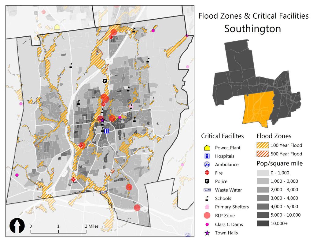
1 Southington Southington, similar to its next-door neighbor Berlin, is a suburban community in the southeast part of the region. Originally an agricultural community, Southington has also hosted industry and now boasts several designated historic districts and a revitalized downtown. Physically, it is among the largest towns in the region, at 36 square miles, and is home to a variety of landscapes. With 39,728 residents in 2000, the town had a population density of 1104 people per square mile. Median age is 42, and 77% of all housing is single-family. According to the Department of Transportation, Southington is projected to see a 50% increase in its population aged 60 and over; this cohort is expected to comprise almost 1/3 of the town s population by Southington is one of the three towns in the region that are not served by public transportation. Challenges Flooding from the Quinnipiac River is the main challenge for Southington. The town is relatively flat throughout, which means that floodwaters tend to recede very slowly. The Plantsville area is particularly hard-hit by flooding. It has an undersized drainage system that needs to be upgraded, especially within the floodplain of the Quinnipiac. Upgrading the system would improve the situation during smaller flood events, although the area would still likely flood during larger events. Woodruff Street is another area with recurrent flooding. Although the publicly-owned culvert was replaced 15 years ago and is in good condition, the channel that runs across private land is undersized and needs to be widened and deepened for a length of approximately 3,000 feet. As the flooding issue occurs on private land, it is beyond the town s ability to remedy. The town s floodplain ordinance mandates zero increase in storm water runoff in flood plain areas, and town staff places high priority on convincing property owners to provide adequate on-site floodwater storage. 67
2 The town faces the same challenges from winter storms as do the other towns in the region: cleanup and management of the storms can be expensive; residents can be isolated by snowy and icy roads; and downed trees can block roads and cause power outages, depriving residents of electricity, communications, and even heat. As in other towns, the vast majority of residents, accustomed to Connecticut's weather, choose to shelter in place, waiting out the storms from the comfort of their own homes. Current Mitigation and Response Activities The town's Open Space and Land Acquisition Committee cites water quality / resource protection and flood control as two of its rationales for acquisitions and targets wetlands and other properties valuable for pursuing those ends The health department keeps lists of crucial facilities and vulnerable populations, and assists with evacuations during emergencies. The health director, Chuck Motes, is also the deputy emergency management director. The water department has a water conservation plan in place, to be used in the event of drought Town tests its emergency operations plan every 12 to 18 months; the last test was on July 15, 2009 Flood plain regulations limit development that can occur in flood zones and flood ways The town participates in the National Flood Insurance Program Participates in DEMHS Region 3 planning activities Goals, Objectives, and Strategies Goal: reduce losses of life and property, and minimize economic consequences of natural hazards. Objective 1: Increase capacity to shelter large numbers of people in the case of an emergency Strategy Priority Lead Hazard S1 Inventory town shelters High Emergency Management Winter Storms S2 Invest in supplies sufficient to stock at least one shelter in case of a major High Emergency Management Winter Storms event S3 Develop a comprehensive shelter plan Medium Emergency Management Winter Storms 68
3 Objective 2: Improve town's capacity to deal with hazards by investing in necessary equipment and upgrading infrastructure S1 S2 S3 S4 Strategy Priority Lead Hazard Invest in emergency generators in order to keep critical facilities online during emergencies Invest in chainsaws and a wood chipper to expedite removal of downed trees Invest in sump pumps to more quickly remove floodwaters Increase capacity of Plantsville drainage system High High Public Works Public Works Winter Storms, Wind Storms Winter Storms, Wind Storms High Public Works Flooding Medium Public Works Flooding Objective 3: Improve citizen notification, awareness, and response time S1 S2 S3 S4 Strategy Priority Lead Hazard Take advantage of the statewide Reverse-911 system offered through Everbridge Develop & distribute household preparedness pamphlet Encourage preparedness workshops in schools Post preparedness pamphlet and town evacuation plans on town website High Administration, Emergency Management High Emergency Management All High Emergency Management All High Emergency Management All All Objective 4: Continue Participation in National Flood Insurance Program Strategy Priority Lead Hazard S1 Continue enforcement of floodplain management ordinances by regulating all new and substantially High Planning & Zoning Flooding improved construction in flood zones S2 Work with FEMA to update FIRMs as necessary High Planning, Public Works Flooding S3 Continue to distribute information about the NFIP to homeowners High Planning Flooding S4 Continue to assist homeowners with amendments to NFIP maps as necessary High Planning Flooding 69
4 Contributors Mark Sciota (Deputy Town Manager / Emergency Management Director), Tony Tranquillo (Director of Public Works), Jim Grappone (Assistant Town Engineer), Mary Savage-Dunham (Town Planner), Jim Butler (Assistant Building Inspector) 70
5
6 Hazus-MH: Flood Event Report Region Name: Southington Flood Scenario: Flood100 Print Date Wednesday, October 1, 2014 Disclaimer: Totals only reflect data for those census tracts/blocks included in the user s study region. The estimates of social and economic impacts contained in this report were produced using Hazus loss estimation methodology software which is based on current scientific and engineering knowledge. There are uncertainties inherent in any loss estimation technique. Therefore, there may be significant differences between the modeled results contained in this report and the actual social
7 Section Page # General Description of the Region 3 Building Inventory 4 General Building Stock Essential Facilities Damage Flood Scenario Parameters 5 Building Damage 6 General Building Stock Essential Facilities Damage Induced Flood Damage 8 Debris Generation Social Impact 8 Shelter Requirements Economic Loss 9 Building-Related Losses Appendix A: Listing for the Region 10 Appendix B: Regional Population and Building Value Data 11 Flood Event Summary Report Page 2 of 11
8 General Description of the Region Hazus is a regional multi-hazard loss estimation model that was developed by the Federal Emergency Management Agency (FEMA) and the National Institute of Building Sciences (NIBS). The primary purpose of Hazus is to provide a methodology and software application to develop multi -hazard losses at a regional scale. These loss estimates would be used primarily by local, state and regional officials to plan and stimulate efforts to reduce risks from multihazards and to prepare for emergency response and recovery. The flood loss estimates provided in this report were based on a region that included 1 county(ies) from the following state(s): - Connecticut Note: Appendix A contains a complete listing of the counties contained in the region. The geographical size of the region is 37 square miles and contains 442 census blocks. The region contains over 15 thousand households and has a total population of 39,514 people (2000 Census Bureau data). The distribution of population by State and County for the study region is provided in Appendix B. There are an estimated 15,079 buildings in the region with a total building replacement value (excluding contents) of 3,576 million dollars (2006 dollars). Approximately 91.86% of the buildings (and 74.09% of the building value) are associated with residential housing. Flood Event Summary Report Page 3 of 11
9 Building Inventory General Building Stock Occupancy Table 1 Building Exposure by Occupancy Type for the Study Region Exposure ($1000) Percent of Total Residential 2,649, % Commercial 612, % Industrial 220, % Agricultural 17, % Religion 39, % Government 9, % Education 26, % Total 3,576, % Table 2 Building Exposure by Occupancy Type for the Scenario Occupancy Exposure ($1000) Percent of Total Residential 1,653, % Commercial 366, % Industrial 191, % Agricultural 14, % Religion 30, % Government 3, % Education 11, % Total 2,271, % Essential Facility Inventory For essential facilities, there are 1 hospitals in the region with a total bed capacity of 74 beds. There are 14 schools, 1 fire stations, 1 police stations and 1 emergency operation centers. Flood Event Summary Report Page 4 of 11
10 Flood Scenario Parameters Study Region Name: Scenario Name: CCRPA Disaster Resilience Flood100 Return period Analyzed: 100 Analysis Option Analyzed: No What-Ifs Flood Event Summary Report Page 5 of 11
11 Building Damage General Building Stock Damage Table 3: Expected Building Damage by Occupancy Substantially Occupancy Count (%) Count (%) Count (%) Count (%) Count (%) Count (%) Agricultural Commercial Education Government Industrial Religion Residential Total Table 4: Expected Building Damage by Building Type Building Substantially Type Count (%) Count (%) Count (%) Count (%) Count (%) Count (%) Concrete ManufHousing Masonry Steel Wood Flood Event Summary Report Page 6 of 11
12 Essential Facility Damage scenario flood event, the model estimates that 74 hospital beds are available in the region. Table 5: Expected Building Damage by Occupancy # Facilities At Least At Least Classification Total Moderate Substantial Loss of Use Fire Stations Hospitals Police Stations Schools If this report displays all zeros or is blank, two possibilities can explain this. (1) None of your facilities were flooded. This can be checked by mapping the inventory data on the depth grid. (2) The analysis was not run. This can be tested by checking the run box on the Analysis Menu and seeing if a message box asks you to replace the existing results. Flood Event Summary Report Page 7 of 11
13 Debris Generation Shelter Requirements Flood Event Summary Report Page 8 of 11
14 Economic Loss Building-Related Losses because of the damage sustained during the flood. Business interruption losses also include the temporary living expenses for those people displaced from their homes because of the flood. business interruption of the region. The residential occupancies made up 27.51% of the total loss. Table 6 below provides a summary of the losses associated with the building damage. Table 6: Building-Related Economic Loss Estimates (Millions of dollars) Category Area Residential Commercial Industrial Others Total Building Loss Building Content Inventory Subtotal Business Interruption Income Relocation Rental Income Wage Subtotal ALL Total Flood Event Summary Report Page 9 of 11
15 Appendix A: County Listing for the Region Flood Event Summary Report Page 10 of 11
16 Appendix B: Regional Population and Building Value Data Building Value (thousand of dollars) Population Residential Non-Residential Total Connecticut Hartford 39,514 2,649, ,459 3,576,365 Total 39,514 2,649, ,459 3,576,365 Total Study Region 39,514 2,649, ,459 3,576,365 Flood Event Summary Report Page 11 of 11
Municipal Mitigation Goals, Objectives, and Strategies
 Municipal Mitigation Goals, Objectives, and Strategies While the risks from natural hazards confronting the seven municipalities of Central Connecticut may be largely similar, priorities, concerns, economic
HAZUS-MH: Earthquake Event Report
 HAZUS-MH: Earthquake Event Report Region Name: El Paso County Earthquake Scenario: El Paso County Random EQ Print Date: February 08, 2006 Disclaimer: The estimates of social and economic impacts contained
Hazus Methodology and Results Report
 Cumberland County 2014 All-Hazard Mitigation Plan Update Appendix G Hazus Methodology and Results Report The Cumberland County HMP used an enhanced Hazus run to model the 1% annual-chanceflood. Enhancements
2014 HAZUS Methodology and Results Reports
 Union County 2014 Hazard Vulnerability Assessment and Mitigation Plan Update Appendix F 2014 HAZUS Methodology and Results Reports F-1 Union County 2014 Hazard Vulnerability Assessment and Mitigation Plan
CITY OF VESTAVIA HILLS
 CITY OF VESTAVIA HILLS FLOODPLAIN MANAGEMENT PLAN FMPC Meeting #3 September 29, 2015 ORGANIZATION OF 2015 FMP 2015 Floodplain Management Plan Structure Chapter 1 Introduction Chapter 2 Community Profile
Table G - 6. Mitigation Actions Identified for Implementation by the City of Kent ( ) (From Wilkin County Master Mitigation Action Chart)
 (From Wilkin County Master Mitigation Action Chart)") Table G - 6. Actions Identified by the () (From Master Action Chart) Multi-Hazard Plan, 2017 Action Comments 5 All-Hazards Local Planning & Regulations Update the Operations Plan on an annual basis. Work
Table G - 6. Actions Identified by the () (From Master Action Chart) Multi-Hazard Plan, 2017 Action Comments 5 All-Hazards Local Planning & Regulations Update the Operations Plan on an annual basis. Work
APPLICATIONS OF EARTHQUAKE HAZARD MAPS TO LAND-USE AND EMERGENCY PLANNING EXAMPLES FROM THE PORTLAND AREA
 APPLICATIONS OF EARTHQUAKE HAZARD MAPS TO LAND-USE AND EMERGENCY PLANNING EXAMPLES FROM THE PORTLAND AREA O. Gerald Uba Metro, Portland, Oregon OVERVIEW The extent to which we understand "below ground"
Earthquakes. & Expansive Soils
 Earthquakes & Expansive Soils January 22, 2009 Plan Update Flanagan & Associates, LLC Consultants Tulsa, OK www.rdflanagan.com rdflanagan@rdflanagan.com Plan can be reviewed at: www.rdflanagan.com/.html
HAZUS-MH: A Predictable Hurricane Risk Assessment Tool for the City of Houston and Harris County
 HAZUS-MH: A Predictable Hurricane Risk Assessment Tool for the City of Houston and Harris County Presented by Melvin G. Spinks, P.E., President Annie Ding, PhD, GISP October 29, 2008 Rice University Contents
Timeframe. Crow Wing County, Baxter, Brainerd, Breezy Point, Crosby, Crosslake, Cuyuna, Deerwood, Emily, Fifty
 Table G - 13. s Identified for by the () (From Crow Wing County Master Chart) 1 5 9 All- Hazards All- Hazards Winter Work to ensure that all Crow Wing County residents are aware of and sign-up for the
Page G Crow Wing County Multi-Hazard Mitigation Plan, 2017
 Table G - 10. s Identified by the () (From Crow Wing County Master Chart) 1 5 All- Hazards All- Hazards Work to ensure that all Crow Wing County residents are aware of and sign-up for the County s Emergency
Risk Identification using Hazus
 Risk Identification using Hazus City of Boston, Suffolk County, MA Dave Shortman, GISP, CFM 6/21/2016 Agenda Objective Project Location Hazus Overview Hazus Level 2 Risk Assessment Comparison and Reporting
West Carroll Parish Hazard Mitigation Plan Update Public Meeting. August 25, 2015 Oak Grove, LA
 West Carroll Parish Hazard Mitigation Plan Update Public Meeting August 25, 2015 Oak Grove, LA Agenda Hazard Mitigation Planning Process SDMI Staff Risk Assessment SDMI Staff Update on Previous/Current
KENTUCKY HAZARD MITIGATION PLAN RISK ASSESSMENT
 KENTUCKY HAZARD MITIGATION PLAN RISK ASSESSMENT Presentation Outline Development of the 2013 State Hazard Mitigation Plan Risk Assessment Determining risk assessment scale Census Data Aggregation Levels
2014 Annual Mitigation Plan Review Meeting
 2014 Annual Mitigation Plan Review Meeting Highland County EMA MEETING OBJECTIVES Understand Your Natural Disaster Risk Review of Previous Plans Current Plan Status Future Activity Plan/Needs of Each Community
Baldwin County, Alabama
 2015 Baldwin County, Alabama Multi-Hazard Mitigation Plan I. Comprehensive Plan A multi-jurisdiction plan City of Bay Minette City of Daphne Town of Elberta City of Fairhope City of Foley City of Gulf
The Use of Geographic Information Systems (GIS) by Local Governments. Giving municipal decision-makers the power to make better decisions
 by Local Governments. Giving municipal decision-makers the power to make better decisions") The Use of Geographic Information Systems (GIS) by Local Governments Giving municipal decision-makers the power to make better decisions Case Study: Examples of GIS Usage by Local Governments in North
The Use of Geographic Information Systems (GIS) by Local Governments Giving municipal decision-makers the power to make better decisions Case Study: Examples of GIS Usage by Local Governments in North
Summary of Available Datasets that are Relevant to Flood Risk Characterization
 Inter-Agency Characterization Workshop February 25-27, 2014 USACE Institute for Water Resources, Alexandria, VA, IWR Classroom Summary of Available Datasets that are Relevant to Characterization National
The Tampa Bay Catastrophic Plan Presentation to CFGIS Users Group FDOT District 5 Urban Offices - Orlando July 30, 2010
 The Tampa Bay Catastrophic Plan Presentation to CFGIS Users Group FDOT District 5 Urban Offices - Orlando July 30, 2010 Brady Smith Senior Planner Tampa Bay Regional Planning Council Introduction Recent
Assumption Parish Hazard Mitigation Plan Update Public Meeting. September 1, 2015 Napoleonville, LA
 Assumption Parish Hazard Mitigation Plan Update Public Meeting September 1, 2015 Napoleonville, LA Agenda Hazard Mitigation Planning Process SDMI Staff Risk Assessment SDMI Staff Update on Previous/Current
Interpretive Map Series 24
 Oregon Department of Geology and Mineral Industries Interpretive Map Series 24 Geologic Hazards, and Hazard Maps, and Future Damage Estimates for Six Counties in the Mid/Southern Willamette Valley Including
Proposed Scope of Work Village of Farmingdale Downtown Farmingdale BOA Step 2 BOA Nomination Study / Draft Generic Environmental Impact Statement
 Proposed Scope of Work Village of Farmingdale Downtown Farmingdale BOA Step 2 BOA Nomination Study / Draft Generic Environmental Impact Statement The scope of work that follows incorporates and covers
Hazus: Estimated Damage and Economic Losses. North Carolina and South Carolina United States
 Hurricane Florence Advisory 53, 12 September 2018 1100 EST (1500Z) Hazus: Estimated Damage and Economic Losses North Carolina and South Carolina United States Caution: Due to the level of uncertainty associated
Impact of Cyclone Nargis
 Lessons Learnt from Nargis Recovery for the Next Disaster International Recovery Forum (2011) 12, JAN 2011, Kobe, Japan Home for over 100 national races. Profile of Myanmar The 2 nd largest country in
West Baton Rouge Parish Hazard Mitigation Plan Update Public Meeting. September 9, 2015 Port Allen, LA
 West Baton Rouge Parish Hazard Mitigation Plan Update Public Meeting September 9, 2015 Port Allen, LA Agenda Hazard Mitigation Planning Process SDMI Staff Risk Assessment SDMI Staff Update on Previous/Current
Bossier Parish Hazard Mitigation Plan Update Public Meeting. August 10, 2016 Bossier City, LA
 Bossier Parish Hazard Mitigation Plan Update Public Meeting August 10, 2016 Bossier City, LA Agenda Hazard Mitigation Planning Process SDMI Staff Risk Assessment SDMI Staff Update on Previous/Current Mitigation
WHAT HAPPENS WHEN A TORNADO STRIKES THE COMMUNITY? Carroll County Sheriff s Office Emergency Management
 WHAT HAPPENS WHEN A TORNADO STRIKES THE COMMUNITY? Carroll County Sheriff s Office Emergency Management WHAT IS EMERGENCY MANAGEMENT? Carroll County Sheriff s Office Emergency Management Agency is responsible
RISK ASSESSMENT COMMUNITY PROFILE NATURAL HAZARDS COMMUNITY RISK PROFILES. Page 13 of 524
 RISK ASSESSMENT COMMUNITY PROFILE NATURAL HAZARDS COMMUNITY RISK PROFILES Page 13 of 524 Introduction The Risk Assessment identifies and characterizes Tillamook County s natural hazards and describes how
Borah Peak Earthquake HAZUS Scenario Project Executive Summary Idaho Bureau of Homeland Security Idaho Geological Survey Western States Seismic
 Borah Peak Earthquake HAZUS Scenario Project Executive Summary Idaho Bureau of Homeland Security Idaho Geological Survey Western States Seismic Policy Council 12/30/2008 The HAZUS-MH analysis of the Borah
Oregon APA Legal Issues Workshop December 7, Tricia Sears, DLCD With information from Bill Burns, DOGAMI
 Oregon APA Legal Issues Workshop December 7, 2018 Tricia Sears, DLCD With information from Bill Burns, DOGAMI How this Topic Arrived WE FREQUENTLY HEAR CONCERNS ABOUT LIABILITY AND TAKINGS. Current federal
4.4 Assessing Vulnerability: Estimating Potential Losses
 4.4 Assessing Vulnerability: Estimating Potential Losses This section presents exposure, damage, and loss estimates, for each of the 8 hazards evaluated. The findings support planning efforts based on
On Page 1, following Paragraph 2 of the Planning Participants subsection, insert the following: 2012 Committee members included:
 Appendix 4: City of West Linn Addendum to the Clackamas County Natural Hazards Mitigation Plan 2012 Amendments and Update The Oregon Partnership for Disaster Resilience prepared this Appendix to the City
REGIONAL HAZARD MITIGATION PLANNING IN SOUTH CENTRAL CONNECTICUT. Association of State Floodplain Managers Conference June 13, 2013 Hartford, CT
 REGIONAL HAZARD MITIGATION PLANNING IN SOUTH CENTRAL CONNECTICUT Association of State Floodplain Managers Conference June 13, 2013 Hartford, CT MULTI-JURISDICTION MITIGATION PLAN South Central Regional
Risk Assessment and Mitigation. Hurricane Checklist
 Risk Assessment and Mitigation Hurricane Checklist Hurricane Checklist Hurricanes are severe tropical storms with sustained winds of at least 74 miles per hour. Hurricane winds can reach 160 miles per
Appendix C Fluvial Flood Hazards
 Appendix C Fluvial Flood Hazards Sea Level Rise Vulnerability Assessment and Adaptation Project March 2019 Contents Contents... i Figures... i Tables... i Definitions, Acronyms, & Abbreviations... ii
Pre-Disaster Natural Hazard Mitigation Plan Guilford, Connecticut History of Hazard Mitigation Planning Authority Disaster Mitigation Act of 2000 (ame
 Pre-Disaster Natural Hazard Mitigation Plan Guilford, Connecticut History of Hazard Mitigation Planning Authority Disaster Mitigation Act of 2000 (amendments to Stafford Act of 1988) Presented by: David
Village of Giltner. Hamilton County Multi-Jurisdictional Hazard Mitigation Plan
 Village of Giltner Hamilton County Multi-Jurisdictional Hazard Mitigation Plan 2014 HISTORY Settlement began in the community of Giltner in 1886 when the Lincoln Land Company, a business that developed
NC Emergency Management A View from the Counties
 NC Emergency Management A View from the Counties Amy Bason, NCACC Rocky Hyder, Henderson County Jeff Batten, Durham County Norman Bryson, Onslow County PARTNERSHIP Emergency Management efforts require
Table-Top Exercise for Emergency Preparedness Evaluation: Little Anse, Isle Madame
 Table-Top Exercise for Emergency Preparedness Evaluation: Little Anse, Isle Madame Alexander Chung, M.Sc. Candidate C-Change Student Research Associate May 2013 The Community of Little Anse Coastal community
SECTION 6 VULNERABILITY ASSESSMENT
 SECTION 6 VULNERABILITY ASSESSMENT This section identifies and quantifies the vulnerability of the MEMA District 1 Region to the significant hazards identified in the previous sections (Hazard Identification
Pacific Catastrophe Risk Assessment And Financing Initiative
 Pacific Catastrophe Risk Assessment And Financing Initiative TIMOR-LESTE September Timor-Leste is expected to incur, on average, 5.9 million USD per year in losses due to earthquakes and tropical cyclones.
8.0 City of New Britain Annex
 Hazard Mitigation Plan for the Former Central Connecticut Region 2016 2021 Update Page 180 8.0 City of New Britain Annex 8.1 Introduction The former Central Connecticut Region, which includes New Britain,
Residents Emergency Response Checklist
 COMMUNITY RESILIENCE PLAN Residents Emergency Response Checklist A helpful guide in the event of extreme weather or bushfire events. < PREVIOUS I NEXT > 02 Purchasing an existing property or building a
From Vulnerability to Resilience And the Tools to Get There. Out of Harm s Way Partnership for the Delaware Estuary August 1, 2012
 From Vulnerability to Resilience And the Tools to Get There Out of Harm s Way Partnership for the Delaware Estuary August 1, 2012 Today s Presentation Tour of New Jersey Challenges Definitions so we re
Running Head: HAZARD MITIGATION PLAN OUTLINE FOR MISSISSIPPI 1
 Running Head: HAZARD MITIGATION PLAN OUTLINE FOR MISSISSIPPI 1 Hazard Mitigation Plan Outline for Mississippi Name: Institution: HAZARD MITIGATION PLAN OUTLINE FOR MISSISSIPPI 2 Hazard Mitigation Plan
Chippewa County Natural Hazards Mitigation Plan
 2014 Chippewa County Natural Hazards Mitigation Plan Prepared for: Chippewa County Office of Emergency Management With the Assistance of: Eastern U.P. Regional Planning & Development Commission April,
Hurricane Readiness for Coastal Communities
 Hurricane Readiness for Participant Guide Developed for: Federal Emergency Management Agency Emergency Management Institute 16825 South Seton Avenue Emmitsburg, MD 21727-8998 Developed by: C² Technologies,
RISK ASSESSMENT IDENTIFYING HAZARDS
 RISK ASSESSMENT IDENTIFYING HAZARDS In order to properly identify mitigation strategies and projects, the hazards that may affect Van Buren County must be identified Iowa s foundation for hazard mitigation
City of Manitou Springs
 March 2018 City of Manitou Springs Implementing Land Use tools to reduce and mitigate natural hazard risk Context & History Past Present Historic homes Older infrastructure Hillside development Creekside
Pacific Catastrophe Risk Assessment And Financing Initiative
 Pacific Catastrophe Risk Assessment And Financing Initiative TUVALU is expected to incur, on average,. million USD per year in losses due to earthquakes and tropical cyclones. In the next 5 years, has
GIS Monroe Geographic Information System March 14, 2018
 GIS Monroe Geographic Information System March 14, 2018 Goals Maintain Enterprise/County-wide geo-database Increase spatial accuracy of data Build and acquire more data layers Increase use of GIS; as another
Module 10 Summative Assessment
 Module 10 Summative Assessment Activity In this activity you will use the three dimensions of vulnerability that you learned about in this module exposure, sensitivity, and adaptive capacity to assess
Pacific Catastrophe Risk Assessment And Financing Initiative
 Pacific Catastrophe Risk Assessment And Financing Initiative PALAU September is expected to incur, on average,.7 million USD per year in losses due to earthquakes and tropical cyclones. In the next 5 years,
Outline of Guideline for Development and Utilization of Tsunami Disaster Management Map
 Outline of Guideline for Development and Utilization of Tsunami Disaster Management Map Port and Airport Research Institute, Japan The Overseas Coastal Area Development Institute of Japan Ports and Harbours
GOAL 7 AREAS SUBJECT TO NATURAL DISASTERS AND HAZARDS. To protect life and property from natural disasters and hazards.
 GOAL 7 AREAS SUBJECT TO NATURAL DISASTERS AND HAZARDS A. GOALS: To protect life and property from natural disasters and hazards. B. POLICIES: 1. Floodplains shall be maintained as natural drainage-ways.
MISSOURI LiDAR Stakeholders Meeting
 MISSOURI LiDAR Stakeholders Meeting East-West Gateway June 18, 2010 Tim Haithcoat Missouri GIO Enhanced Elevation Data What s different about it? Business requirements are changing.fast New data collection
Appendix E Guidance for Shallow Flooding Analyses and Mapping
 Appendix E Guidance for Shallow Flooding Analyses and Mapping E.1 Introduction Different types of shallow flooding commonly occur throughout the United States. Types of flows that result in shallow flooding
Initiative. Country Risk Profile: papua new guinea. Better Risk Information for Smarter Investments PAPUA NEW GUINEA.
 Pacific Catastrophe Risk Assessment And Financing Initiative PAPUA NEW GUINEA September 211 Country Risk Profile: papua new is expected to incur, on average, 85 million USD per year in losses due to earthquakes
Use of Geospatial data for disaster managements
 Use of Geospatial data for disaster managements Source: http://alertsystemsgroup.com Instructor : Professor Dr. Yuji Murayama Teaching Assistant : Manjula Ranagalage What is GIS? A powerful set of tools
A Simple Procedure for Estimating Loss of Life from Dam Failure. Wayne J. Graham, P.E. 1
 A Simple Procedure for Estimating Loss of Life from Dam Failure Wayne J. Graham, P.E. 1 INTRODUCTION Evaluating the consequences resulting from a dam failure is an important and integral part of any dam
Copernicus Overview. Major Emergency Management Conference Athlone 2017
 Copernicus Overview Major Emergency Management Conference Athlone 2017 Copernicus is a European programme implemented by the European Commission. The services address six thematic areas: land, marine,
STEUBEN COUNTY, NEW YORK. Hazard Analysis Report
 STEUBEN COUNTY, NEW YORK Hazard Analysis Report Prepared by: April 1, 2014 Background On April 1, 2014 the Steuben County Office of Emergency Management conducted a hazard analysis using the automated
7.0 Town of Burlington Annex
 Hazard Mitigation Plan for the Former Central Connecticut Region 2016 2021 Update Page 157 7.0 Town of Burlington Annex 7.1 Introduction The former Central Connecticut Region, which includes Burlington,
Pacific Catastrophe Risk Assessment And Financing Initiative
 Pacific Catastrophe Risk Assessment And Financing Initiative VANUATU September 211 Country Risk Profile: VANUATU is expected to incur, on average, 48 million USD per year in losses due to earthquakes and
Appendix F Public Outreach & Engagement Documentation
 Appendix F Public Outreach & Engagement Documentation Page F - 1 Page F - 2 Page F - 3 Page F - 4 Page F - 5 Page F - 6 Page F - 7 Page F - 8 Page F - 9 Page F - 10 Page F - 11 Page F - 12 https://scse.d.umn.edu/steele-county-mhmp
HORIZON 2030: Land Use & Transportation November 2005
 PROJECTS Land Use An important component of the Horizon transportation planning process involved reviewing the area s comprehensive land use plans to ensure consistency between them and the longrange transportation
WINTER STORM Annex II
 WINTER STORM Annex II I. PURPOSE A. This annex has been prepared to ensure a coordinated response by state agencies to requests from local jurisdictions to reduce potential loss of life and to ensure essential
Climate Risk Visualization for Adaptation Planning and Emergency Response
 Climate Risk Visualization for Adaptation Planning and Emergency Response NCR Flood Fact Finding Workshop Ricardo Saavedra ricardo@vizonomy.com Social Media, Mobile, and Big Data St. Peter s Basilica,
MUNICIPALITY OF ANCHORAGE PUBLIC TRANSPORTATION DEPARTMENT AnchorRIDES PARATRANSIT SYSTEM
 Purpose: The Public Transportation Department (PTD) and AnchorRIDES paratransit contractor will provide transportation in as safe a manner as effectively possible. Paratransit vehicles primarily operate
The UN-GGIM: Europe core data initiative to encourage Geographic information supporting Sustainable Development Goals Dominique Laurent, France
 INSPIRE conference Strasbourg 6 September 2017 The UN-GGIM: Europe core data initiative to encourage Geographic information supporting Sustainable Development Goals Dominique Laurent, France Introduction
Application #: TEXT
 TOWN OF FORT MYERS BEACH 2008 PROPOSED COMPREHENSIVE PLAN AMENDMENTS Application #: 2008-13-TEXT Description: Modify the Coastal Management and Future Land Use Elements to reflect the state s new definition
Preparing for Earthquakes in Dallas-Fort Worth Applying HAZUS to assess shelter accessibility. Crystal Curtis
 Preparing for Earthquakes in Dallas-Fort Worth Applying HAZUS to assess shelter accessibility Crystal Curtis Introduction 20+ earthquakes in the city of Irving October 2014 to March 2015 HAZUS can be used
COMMUNITY EMERGENCY RESPONSE TEAM FLOODS INTRODUCTION
 INTRODUCTION Floods are one of the most common hazards in the United States. A flood occurs any time a body of water rises to cover what is usually dry land. Flood effects can be local, impacting a neighborhood
Management Workshop. Sponsored by: University of Florida Hinkley Center for Solid and Hazardous Waste
 Hurricane Debris Management Workshop Sponsored by: Alachua County Solid Waste and Emergency Management University of Florida Hinkley Center for Solid and Hazardous Waste April 9, 2008 Agenda 9:45 10:00
CLAREMONT MASTER PLAN 2017: LAND USE COMMUNITY INPUT
 Planning and Development Department 14 North Street Claremont, New Hampshire 03743 Ph: (603) 542-7008 Fax: (603) 542-7033 Email: cityplanner@claremontnh.com www.claremontnh.com CLAREMONT MASTER PLAN 2017:
Mitigation planning in Epirus- The case of frost and snowfalls. Thematic seminar Epirus September 2011
 Mitigation planning in Epirus- The case of frost and snowfalls Thematic seminar Epirus September 2011 1 Structure of Mitigation Planning in Greece First Level: General Plan for Civil Protection Ksenokratis
In the early morning hours of
 Figure 1. Brace that Chimney! Bracing of masonry chimneys is very difficult to do properly and has generally been ineffective in preventing their failure during earthquakes. While replacement of the chimney
Flood Hazard Zone Modeling for Regulation Development
 Flood Hazard Zone Modeling for Regulation Development By Greg Lang and Jared Erickson Pierce County GIS June 2003 Abstract The desire to blend current digital information with government permitting procedures,
Advisory Committee Meeting December 5, 2012
 SOUTH CENTRAL REGION MULTI-JURISDICTION HAZARD MITIGATION PLAN Advisory Committee Meeting December 5, 2012 MEETING PURPOSE Review Municipality Meetings and Capabilities Review Hazard Identification and
Discovery Data Questionnaire
 Region III Discovery Data Questionnaire Thank you for taking the time to complete this Discovery Data questionnaire. It will provide important information to help FEMA better understand flood risk issues
Understanding China Census Data with GIS By Shuming Bao and Susan Haynie China Data Center, University of Michigan
 Understanding China Census Data with GIS By Shuming Bao and Susan Haynie China Data Center, University of Michigan The Census data for China provides comprehensive demographic and business information
Monitoring Scour Critical Bridges During Floods For Local Bridge Owners. Presented by
 Monitoring Scour Critical Bridges During Floods For Local Bridge Owners Presented by SAFETY FIRST DO NOT ENDANGER YOURSELF OR OTHERS WHILE MONITORING BRIDGES DO NOT ENTER FLOOD WATERS FLOOD WATERS INCLUDE
Table 31. Steele County Master Mitigation Action Chart ( )
") Table 31. Master Action Chart () Action Comments on Planning 1 All-Hazards 2 All-Hazards Education & Awareness Programs Work to ensure that all residents are aware of and sign-up for the Everbridge emergency
Table 31. Master Action Chart () Action Comments on Planning 1 All-Hazards 2 All-Hazards Education & Awareness Programs Work to ensure that all residents are aware of and sign-up for the Everbridge emergency
Environmental Analysis, Chapter 4 Consequences, and Mitigation
 Environmental Analysis, Chapter 4 4.17 Environmental Justice This section summarizes the potential impacts described in Chapter 3, Transportation Impacts and Mitigation, and other sections of Chapter 4,
Assessing Social Vulnerability to Biophysical Hazards. Dr. Jasmine Waddell
 Assessing Social Vulnerability to Biophysical Hazards Dr. Jasmine Waddell About the Project Built on a need to understand: The pre-disposition of the populations in the SE to adverse impacts from disaster
Electric Distribution Storm Hardening Initiatives. Paul V. Stergiou Distribution Engineering October 14 th, 2015
 Consolidated Edison Company of New York, Inc. Electric Distribution Storm Hardening Initiatives Paul V. Stergiou Distribution Engineering October 14 th, 2015 Energy For New York City And Westchester 3.3
Grimes County Hazard Mitigation
 Grimes County Hazard Mitigation Mitigating Risk: Protecting Grimes County from All Hazards 2013-2018 Department of Emergency Management Anderson, Texas EXECUTIVE SUMMARY PURPOSE AND PROCESS OF DEVELOPMENT
PUBLIC SAFETY POWER SHUTOFF POLICIES AND PROCEDURES
 PACIFIC GAS AND ELECTRIC COMPANY PUBLIC SAFETY POWER SHUTOFF POLICIES AND PROCEDURES SEPTEMBER 2018 1 PACIFIC GAS AND ELECTRIC COMPANY PUBLIC SAFETY POWER SHUTOFF POLICIES AND PROCEDURES SEPTEMBER 2018
Pequabuck River Flooding Study and Flood Mitigation Plan The City of Bristol and Towns of Plainville and Plymouth, CT
 Pequabuck River Flooding Study and Flood Mitigation Plan The City of Bristol and Towns of Plainville and Plymouth, CT Raymond Rogozinski and Maged Aboelata The City of Bristol and Towns of Plainville and
RETA 6422: Mainstreaming Environment for Poverty Reduction Category 2 Subproject
 RETA 6422: Mainstreaming Environment for Poverty Reduction Category 2 Subproject A. Basic Data 1. Subproject Title: Poverty-Environment Mapping to Support Decision Making 2. Country Director: Adrian Ruthenberg
Flood Scenario Worksheet
 Flood Scenario Worksheet Scenario adapted from: http://www.epa.gov/watersecurity/tools/trainingcd/simple/source/scenario-8/ssc8-0.pdf Simple Tabletop Exercise, Interdependency Natural Disaster Scenario,
OnTheMap for Emergency Management
 OnTheMap for Emergency Management Robert Pitts Geographer/Project Manager Longitudinal Employer Household Dynamics (LEHD) Center for Economic Studies U.S. Census Bureau Jody Hoon-Star Geographer/Application
2014 Russell County Hazard Mitigation Plan Update STAKEHOLDERS AND TECHNICAL ADVISORS MEETING 2/6/14
 2014 Russell County Hazard Mitigation Plan Update STAKEHOLDERS AND TECHNICAL ADVISORS MEETING 2/6/14 Welcome and Introductions We cannot direct the wind, but we can adjust our sails. 44 CFR 201.6; Local
Tornado Safety: 2013 Practical Steps for Weather-Related Emergencies
 Tornado Safety: 2013 Practical Steps for Weather-Related Emergencies Campbell County Public Safety One County, One Mission, One Call Away Tornado Preparedness Day March 12, 2013 As 62 tornadoes struck
Hurricane Preparation and Recovery. October 11, 2011 Jon Nance, Chief Engineer, NCDOT
 Hurricane Preparation and Recovery October 11, 2011 Jon Nance, Chief Engineer, NCDOT North Carolina & Severe Weather Our state often bears the brunt of storms, which include: Ice storms Snow storms Heavy
PARTICIPANT SECTION CITY OF OSHKOSH
 PARTICIPANT SECTION CITY OF OSHKOSH North Platte NRD Multi-Jurisdictional Hazard Mitigation Plan Update January 2016 North Platte NRD Multi-Jurisdictional Hazard Mitigation Plan Update January 2016 1 INTRODUCTION
Madison County Hazard Mitigation
 Madison County Hazard Mitigation Mitigating Risk: Protecting Madison County from All Hazards 2013-2018 Emergency Management 101 W. Main Street, Suite B, 13 Madisonville, Texas 77864 EXECUTIVE SUMMARY PURPOSE
Managing Floods at Boscastle. Learning Objective: Examine the benefits of managing floods
 Managing Floods at Boscastle Learning Objective: Examine the benefits of managing floods Learning Outcomes: Describe how Boscastle has been affected by flooding Explain strategies to reduce the risk Evaluate
1 IA 1 Severe Weather (Including. Landslides)
") 1 IA 1 Severe Weather (Including Landslides) THIS PAGE LEFT BLANK INTENTIONALLY 1 Purpose The purpose of this annex is to provide a framework of coordination among agencies to help ensure the safety of
1 IA 1 Severe Weather (Including Landslides) THIS PAGE LEFT BLANK INTENTIONALLY 1 Purpose The purpose of this annex is to provide a framework of coordination among agencies to help ensure the safety of
A More Comprehensive Vulnerability Assessment: Flood Damage in Virginia Beach
 A More Comprehensive Vulnerability Assessment: Flood Damage in Virginia Beach By Raj Shah GIS in Water Resources Fall 2017 Introduction One of the most obvious effects of flooding events is death. Humans