Tsunami Risk Reduction Measures Phase 2
|
|
|
- Patience Foster
- 6 years ago
- Views:
Transcription


1 Tsunami Risk Reduction Measures Phase 2 November 2009
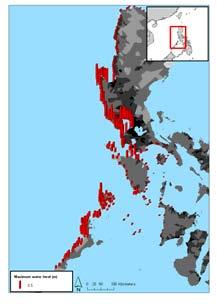
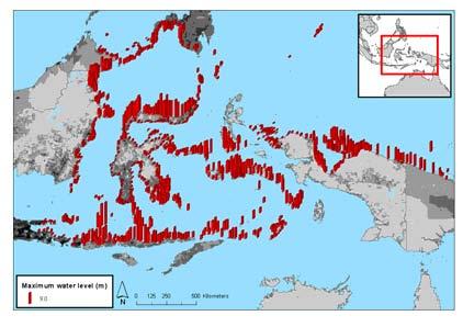
2 Cover pictures; Initial water displacements (m) for the three northernmost Sunda Arc scenarios of magnitude M 8.55, 8.53 and 8.60 respectively, as well as the M 8.86 Burma fault scenario. Seismicity of the study region for , with symbols differentiating the magnitudes. Merged tsunami hazard map for Sri Lanka. Merged tsunami hazard map for the Philippines Merged tsunami hazard map for Eastern Indonesia The designations employed and the presentation of material in this publication do not imply the expression of any opinion whatsoever on the part of the CCOP Technical Secretariat concerning the legal status of any country, territory, city or area or of its authorities, or concerning the delimitation of its frontiers or boundaries. Note: The conclusions and recommendations of this publication have not been specifically endorsed by, or reflect the views of the organizations which have supported the production of this project, both financially and with content. Coordinating Committee for Geosciences Programmes in East and Southeast Asia, 2009
3 Project Project: Tsunami Risk Reduction Measures phase 2 Document No.: R Document title: Evaluation tsunami hazard in Sri Lanka Date: 6 November 2009 Client Client: CCOP Technical Secretariat Client s contact person: Niran Chaimanee Contract reference: Contract between CCOP and NGI of 17. April 2008 For NGI Project manager: Prepared by: Reviewed by: Kjell Karlsrud Finn Løvholt, Sylfest Glimsdal, Daniela Kühn, Hilmar Bungum, Bjørn Kalsnes, Bjørn Vidar Vangelsten Carl Bonnevie Harbitz Summary This report presents tsunami hazard analyses for the coastline of Sri Lanka. The tsunami threat towards Sri Lanka originates from a range of potential megathrust earthquakes extending from the Burma Fault in the North, to the Sumatra Trench in the South. The return periods associated with the earthquakes ranges from years. A rough regional evaluation based on numerical simulations concludes that maximum water levels of 3-7 m along the East and South coast of Sri Lanka may occur. Even though these large water levels constitutes a threat, a propagation time of 2 hours or more suggests that a well functioning warning system combined with evacuation drills and public awareness could prove effective. Today, the tsunami hazard is lowered somewhat due to the release of stress in the Sumatra-Andaman section of the Sunda Arc after the 2004 Great
4 Summary (cont.) Document No.: R Page: 4 Sumatra earthquake; however the tsunami risk due to earthquakes along the same segment will increase. Elements required performing risk analyses are also highlighted in this report. The elements are also included in a model for tsunami vulnerability and risk at a local level, which is detailed in one of the Appendices of the main project report, NGI (2009).
5 Contents Document No.: R Page: 5 1 Introduction 6 2 Definitions 7 3 Historical tsunamis along the Western Sunda Arc and Burma 10 4 Tsunamigenic earthquake scenarios with return periods 11 5 Tsunami simulations and hazard evaluations for Sri Lanka 12 6 Required input for risk evaluations 14 7 Acknowledgements 14 8 References 14 Review and reference page
6 Document No.: R Page: 6 1 Introduction The project Tsunami Risk Assessment and mitigation in S&SE Asia Phase 2 has been financed by The Norwegian Ministry of Foreign Affairs (MFA). The Coordinating Committee for Geoscience Programmes in East and Southeast Asia (CCOP), through their Technical Secretariat in Bangkok, acted as the project responsible institution towards MFA. The Norwegian Geotechnical Institute (NGI) had the role as Technical Executing Organisation (TEO). NGI subcontracted NORSAR for performing the seismological analyses required. The project was contracted in 2008 with four Asian countries: Indonesia, the Philippines, Vietnam, and Sri Lanka. The main goals of the project have been to reduce the tsunami risk in South and Southeast Asia by: Enhanced assessment of tsunami hazard and recommendations of risk mitigation measures in specified regions Enhanced capacities of hazard assessment and risk reduction for regional, national, and local institutions The detailed scope of work (SoW) for the invited countries the Philippines, Indonesia, Vietnam, and Sri Lanka varied according to the needs defined from previous tsunami hazard assessments and the capabilities of the individual countries. The SoW s were agreed in project meetings with the countries in the early phase of the project. In Sri Lanka, the National Disaster Management Center is the cooperating partner. This report presents tsunami hazard analyses dedicated to the coastline of Sri Lanka (a map is given in Figure 1). Elements required performing risk analyses are also highlighted. In the complete project report (NGI, 2009), findings for all the four countries and more elaborate details of the analysis relevant for Sri Lanka are given. For this purpose, NGI (2009) is extensively cited herein. It is emphasised that this report considers only potential tsunamis of seismic origin, hence tsunamis generated by landslides and volcanoes are omitted. Moreover, it is stressed that a scenario based approach rather than a full probabilistic method is applied in this report. Some of the scenarios described here are based on the Tsunami Phase I risk study of possible future tsunamis towards Thailand (NGI, 2006; Løvholt et al., 2006). However, the current hazard study towards Sri Lanka includes a revised and extended list of large scale scenarios due to the more exposed location of Sri Lanka compared to western Thailand.
 is endeavoured.")
7 Document No.: R Page: 7 Figure 1: Map of Sri Lanka.. 2 Definitions Below, some definitions of technical key terms used in this text are given to help the reader. As far as possible, compatibility with the UNESCO-IOC tsunami glossary (UNESCO-IOC, 2006) is endeavoured. In addition, a brief definition sketch defining the parameters related to the tsunami inundation process is given in Figure 2. Fault - A fracture or a zone of fractures along which displacement has occurred parallel to the fracture. Earthquakes are caused by a sudden rupture along a fault or fault system; the ruptured area may be up to several thousand square kilometers. Relative movements across a fault may typically be tens of centimeters for magnitude earthquakes, several meters for magnitude 7-9 earthquakes.
8 Flow depth Water elevation above land during inundation. Hazard - Probability that a particular danger (threat) occurs within a given period of time. Here, the tsunami hazard is the maximum water level associated with a scenario return period. Inundation distance Maximum horizontal penetration of the tsunami from the shoreline (see Figure 2). Magnitude - A measure of earthquake size at its source. Magnitude was defined by C. Richter in 1935 as: The logarithm to the trace amplitude in mm on a standard Wood-Anderson seismometer located 100 km from the epicenter The Wood-Anderson instrument measures the responses in the period range near 1 sec. Other magnitude scales have later been devised based on the responses measured in other period ranges, and on maximum amplitudes of specific wave forms. In this report, we mostly refer to the moment magnitude (with abbreviation Mw). The moment magnitude is based on the seismic moment computed directly from source parameters or from long period components in the earthquake record. Symbol M is also used for this magnitude. Maximum water level Here, defined as the largest water elevation above the still water level (see Figure 2). Probability - A measure of the degree of certainty. This measure has a value between zero (impossibility) and 1.0 (certainty). It is an estimate of the likelihood of the magnitude of the uncertain quantity, or the likelihood of the occurrence of the uncertain future event. Return period - Average time period between events of a given size in a particular region, cycle time. Risk - Measure of the probability and severity of an adverse effect to life, health, property, or the environment. Quantitatively, Risk = Hazard Potential Worth of Loss. This can be also expressed as Probability of an adverse event times the consequences if the event occurs. Run-up height Water level above the still water level at the inundation limit (see Figure 2). Surface elevation Here, defined as the water elevation relative to the mean sea (can be negative or positive). See Figure 2 for a definition sketch. Threat - The natural phenomenon that could lead to damage, described in terms of its geometry, mechanical and other characteristics. The danger can be an existing one (such as a creeping slope) or a potential one (such as a tsunami). The characterization of a danger or threat does not include any forecasting. Here, the tsunami threat is mostly reported as the maximum water level. Trench - Topographic depressions of the sea floor. Vulnerability - (1) The degree of loss to a given element at risk, or set of such elements, resulting from an event of a given magnitude or intensity, usually expressed on a scale from 0 (no loss) to 1 (total loss). (2) Degree of damage caused by various levels of loading. Document No.: R Page: 8
9 Figure 2: Definition sketch for tsunami parameters. Document No.: R Page: 9

10 Document No.: R Page: 10 3 Historical tsunamis along the Western Sunda Arc and Burma Figure 3: Source location and year of occurrence for recorded earthquake generated historical tsunamis along the western Sunda Arc and Burma with source information. Yellow markers indicate non seismic or unknown sources, red markers indicate seismic sources. Large stars magnitudes M 8; small stars 8.5; > M 8.0; squares 8.0 > M 7.5; circles M < 7.5; asterisk, no magnitude reported. Upward-pointing triangles indicate volcanoes or combinations of volcanoes and other sources. Downward-pointing triangles indicate landslides or landslides and earthquakes. Diamonds indicate unknown sources.
11 Document No.: R Page: 11 Figure 3 shows historical tsunami events along the western Sunda Arc and Burma. The historical events reveal 5 megathrust events with magnitude larger than 8.5 along Sumatra. Along the Sunda Arc north of Sumatra, reported magnitudes do not exceed 7.9 (the 1881 earthquake), but the northward rupture of the 2004 Indian Ocean tsunami must be kept in mind. Finally, in 1762, a large earthquake of proposed upper limit of magnitude 8.8 possibly generated a tsunami (Cummins 2007) along the Arakan Fault near Burma and Bangladesh. The existence of large historical earthquakes from southern Sumatra north to Bangladesh illustrates the potential for these fault zones to generate destructive tsunamis over transoceanic distances. 4 Tsunamigenic earthquake scenarios with return periods The seabed displacements due to various earthquake scenarios that may generate tsunamis posing a threat to the coastlines of Sri Lanka are shown in Figure 4. For details on the computation of the seabed displacements, see NGI (2009). For the north-western Sunda Arc and Burma the parameterization essentially comes from an earlier study (Løvholt et al., 2006) where it was concluded that it most likely will take more than 400 years for another event of similar size (>M9) to occur again (the return period is likely to be even longer, see also Jankaew et al., 2008), and that scenario events of the order of M 8.5 may have return periods of the order of 200 years (but occurring less regularly than the megathrust events). It is added that, the northernmost source in Figure 4 complies with the one given by Cummins (2007). Cummins (2007) also estimates a return period of 500 years for a megathrust earthquake along the Burma fault. It is noted that the possibility of another megathrust earthquake of similar magnitude as the 2004 Indian Ocean extending from Sumatra to the Andaman Islands is highly unlikely today (Løvholt et al., 2006; NGI, 2006). However, megathrust earthquakes of magnitudes equal to or larger than 9 may occur along Sumatra, and significant impact of such events towards southern Sri Lanka cannot be excluded. For the south-western part of the Sunda Arc (off western Sumatra), two megathrust scenario earthquakes of magnitudes larger than 9 are defined, as shown in Figure 4. Sieh (2006) reports return periods of years for megathrust events in this region.
, as well as the magnitude M w 8.86 Burma fault scenario.")

12 Document No.: R Page: 12 Figure 4: Left panel: Upper panel: Initial water displacements (m) for the three northernmost Sunda Arc scenarios of magnitudes M w 8.55, 8.53, and 8.60, respectively (the two northernmost ones partly overlapping), as well as the magnitude M w 8.86 Burma fault scenario. Right panel: Initial water displacements (m) of the two south-western Sunda Arc scenarios of magnitudes 9.19 and 9.13 respectively (partly overlapping). 5 Tsunami simulations and hazard evaluations for Sri Lanka For the scenarios shown in Figure 4, tsunami simulations were performed in the Bengal Bay, and for the Sumatra scenarios also for the Indian Ocean, using a dispersive wave propagation model described by NGI (2009). For all simulations, results were compiled for different offshore control points along the Sri Lankan coastline. For each control point, the largest surface elevation from all simulations was extracted. The further amplification of the surface elevation to the maximum water level was computed using the method of amplification factors described by NGI (2009). This method is an approximate way of incorporating wave amplification regionally, and may be used to give a rough overall picture of the tsunami hazard. Figure 5 shows the resulting maximum water level evaluated at different locations along the Sri Lankan coastline. The largest waves are mostly originating from earthquake scenarios between Sumatra and Andaman, and are hence associated with return periods of more than 400 years. However, for some south-eastern locations of the Island, the largest waves originate from earthquakes off southern Sumatra, having return periods of roughly years. Clearly, the resulting maximum water levels displayed in Figure 5 show that tsunamis still represent a severe threat, and that Sri Lanka should be prepared for future tsunamis. On the other hand, the potential maximum water levels, particularly in the southern and

13 Document No.: R Page: 13 western part of Sri Lanka, are clearly smaller than the run-up heights and maximum water levels found for the 2004 Indian Ocean tsunami (Goff et al., 2006). It is finally noted that for all locations along the Sri Lankan coastline, the travel time of the tsunami is generally at least two hours. Such large travel times are expected to increase the success rate of a well functioning warning system. On the other hand, a natural warning of sea withdrawal will not take place in Sri Lanka, as the positive wave will arrive first. Figure 5: Maximum water level caused by credible worst case tsunami scenarios along the Sri Lankan coastline. It is stressed that although the control points are located offshore, the water levels represent shore line values. Rough estimates of the return periods range from approximately years. Three of the southern locations are associated with years return periods (maximum water levels of 1.8, 2.5, and 4.7 m); whereas the other locations are associated with years return periods.
14 Document No.: R Page: 14 6 Required input for risk evaluations The previous chapters briefly present the tsunami hazard towards Sri Lanka for large scale events. Risk analyses, however, also include the effects a tsunami event may have on a society, ranging from number of fatalities to economical or environmental consequences of a disaster. This project is primarily focussed on tsunami risk related to loss of human lives (mortality risk). Key elements in such risk analyses (beyond the hazard analyses described above) are elements at risk and vulnerability. In coming studies, the following information is therefore required: Demographic maps along the coastline showing the population density or numbers versus elevation height. Vulnerability factors related to physical elements (arrival time, housing, building types, number of floors, infrastructure, etc.) and social elements (training, age, gender etc.). Existing and planned early warning systems and mitigation measures. Risk management systems such as emergency plans, awareness procedures, stakeholder processes, etc. In the main project report, NGI (2009) presents a methodology for tsunami risk assessment for an example case study in the city of Batangas, the Philippines. This methodology demonstrates some elements that enter the risk assessment procedure. 7 Acknowledgements The NGI and NORSAR staffs in charge of producing this report greatly acknowledge the contributions made from the coordinating committee CCOP under the guidance of Mr. Niran Chaimanee, and from our partner in Sri Lanka, the Disaster Management Center, DMC. 8 References Cummins, P.R. (2007). The potential for giant tsunamigenic earthquakes in the northern Bay of Bengal. Nature, 449, Goff, J., Liu, P. L.-F., Higman, B., Morton, R., Jaffe, B.E., Fernando, H., Lynett, P., Fritz, H., Synolakis, C., and Fernando, S. (2006). Sri Lanka Field Survey after the December 2004 Indian Ocean Tsunami. Earthquake Spectra, 22, S3, S155 S172. Jankaew, K., Atwater, B.F., Sawai, Y., Choowong, M., Charoentitirat, T., Martin, M.E., and Prendergast, A. (2008). Medieval forewarning of the 2004 Indian Ocean tsunami in Thailand. Nature, 455, , doi: /nature07373.
15 Document No.: R Page: 15 Løvholt, F., Bungum, H., Harbitz, C.B., Glimsdal, S., Lindholm, C.D., and Pedersen, G. (2006). Earthquake related tsunami hazard along the western coast of Thailand. Nat. Hazards Earth Sys. Sci., 6, NGI (2006). Tsunami Risk Reduction Measures with Focus on Land use and Rehabilitation, NGI report , available at: F:\i\41\KOR\Informasjon\Ekstern\ summary report-complete.pdf NGI (2009). Tsunami Risk Reduction Measures phase 2 Main Report. NGI report no R. Sieh, K. (2006). Sumatran Megathrust Earthquakes - From Science to Saving Lives. Philos. Trans. R. Soc. London A 364(1845), UNESCO-IOC (2006). Tsunami Glossary.
16
17
18
News Release December 30, 2004 The Science behind the Aceh Earthquake
 News Release December 30, 2004 The Science behind the Aceh Earthquake PASADENA, Calif. - Kerry Sieh, the Robert P. Sharp Professor of Geology at the California Institute of Technology and a member of Caltech's
Indian Ocean Tsunami Warning System: Example from the 12 th September 2007 Tsunami
 Indian Ocean Tsunami Warning System: Example from the 12 th September 2007 Tsunami Charitha Pattiaratchi 1 Professor of Coastal Oceanography, The University of Western Australia Email: chari.pattiaratchi@uwa.edu.au
Tsunami Risk Mitigation Strategy for Thailand. Kjell Karlsrud Norwegian Geotechnical Institute (NGI)
") Tsunami Risk Mitigation Strategy for Thailand Kjell Karlsrud Norwegian Geotechnical Institute (NGI) The project was undertaken by NGI in cooperation with: NORSAR, UiB, UiO, NIBR, B.Heyerdahl, NTNU, Sintef
Tsunami Risk Mitigation Strategy for Thailand Kjell Karlsrud Norwegian Geotechnical Institute (NGI) The project was undertaken by NGI in cooperation with: NORSAR, UiB, UiO, NIBR, B.Heyerdahl, NTNU, Sintef
NUMERICAL SIMULATION OF TSUNAMI PROPAGATION AND INUNDATION ALONG THE RAKHINE COAST AREAS IN MYANMAR
 NUMERICAL SIMULATION OF TSUNAMI PROPAGATION AND INUNDATION ALONG THE RAKHINE COAST AREAS IN MYANMAR Su Hninn Htwe Supervisor: Bunichiro SHIBAZAKI MEE12619 Yushiro FUJII ABSTRACT This study aimed to assess
Advisors: Arcadii Grinshpan, Mathematics and Statistics Rocco Malservisi, School of Geosciences. Problem Suggested By: Rocco Malservisi
 Undergraduate Journal of Mathematical Modeling: One + Two Volume 8 2018 Spring 2018 Issue 2 Article 6 Tsunami Waves Samantha Pennino University of South Florida Advisors: Arcadii Grinshpan, Mathematics
Preparation for Future Earthquake and Tsunami Hazards: Lessons Learned from the 2004 Sumatra-Andaman Earthquake and the Asian Tsunami
 First International Conference of Aceh and Indian Ocean Studies Organized by Asia Research Institute, National University of Singapore & Rehabilitation and Construction Executing Agency for Aceh and Nias
On Tsunami Risk Assessment for the West Coast of Thailand
 On Tsunami Risk Assessment for the West Coast of Thailand Farrokh Nadim International Centre for Geohazards (ICG) / Norwegian Geotechnical Institute Thomas Glade University of Bonn Geohazards - Technical,
Lessons from the 2004 Sumatra earthquake and the Asian tsunami
 Lessons from the 2004 Sumatra earthquake and the Asian tsunami Kenji Satake National Institute of Advanced Industrial Science and Technology Outline 1. The largest earthquake in the last 40 years 2. Tsunami
Evaluation of Tsunami Risk Posed to Sri Lanka by Potential Mega-Thrust Earthquakes in the Makran Subduction Zone
 1 ENGINEER - Vol. XXXXII, No. 01, pp. [21-28], 2009 The Institution of Engineers, Sri Lanka Evaluation of Tsunami Risk Posed to Sri Lanka by Potential Mega-Thrust Earthquakes in the Makran Subduction Zone
Wainui Beach Management Strategy (WBMS) Summary of Existing Documents. GNS Tsunami Reports
 Summary of Existing Documents. GNS Tsunami Reports") Wainui Beach Management Strategy (WBMS) Summary of Existing Documents GNS Tsunami Reports a) Review of Tsunami Hazard and Risk in New Zealand ( National Risk Report ) b) Review of New Zealand s Preparedness
Wainui Beach Management Strategy (WBMS) Summary of Existing Documents GNS Tsunami Reports a) Review of Tsunami Hazard and Risk in New Zealand ( National Risk Report ) b) Review of New Zealand s Preparedness
2. Tsunami Source Details
 2. Tsunami Source Details The Northland area faces a range of potential tsunamigenic sources that include several local and distant fault systems and underwater landslides. A NIWA study (Goff et al. 2006)
Disclaimer. This report was compiled by an ADRC visiting researcher (VR) from ADRC member countries.
 from ADRC member countries.") Disclaimer This report was compiled by an ADRC visiting researcher (VR) from ADRC member countries. The views expressed in the report do not necessarily reflect the views of the ADRC. The boundaries and
Disclaimer This report was compiled by an ADRC visiting researcher (VR) from ADRC member countries. The views expressed in the report do not necessarily reflect the views of the ADRC. The boundaries and
Introduction to Environmental Geology, 5e Case History: Indonesian Tsunami Indonesian Tsunami (2) Introduction Historic Tsunamis
 Introduction Historic Tsunamis") 1 2 3 4 5 6 7 8 9 Introduction to Environmental Geology, 5e Chapter 7 Tsunami Case History: Indonesian Tsunami December 26, 2004, within a few hours, close to 250,000 people were killed With no warning
1 2 3 4 5 6 7 8 9 Introduction to Environmental Geology, 5e Chapter 7 Tsunami Case History: Indonesian Tsunami December 26, 2004, within a few hours, close to 250,000 people were killed With no warning
Earthquake Hazards. Tsunami
 Earthquake Hazards Tsunami Review: What is an earthquake? Earthquake is the vibration (shaking) and/or displacement of the ground produced by the sudden release of energy. The point inside the Earth where
Introduction to Environmental Geology, 5e
 Lecture Presentation prepared by X. Mara Chen, Salisbury University Introduction to Environmental Geology, 5e Edward A. Keller Chapter 7 Tsunami Case History: Indonesian Tsunami December 26, 2004, within
Earthquake Hazards. Tsunami
 Earthquake Hazards Tsunami Measuring Earthquakes Two measurements that describe the power or strength of an earthquake are: Intensity a measure of the degree of earthquake shaking at a given locale based
On Tsunami Risk Assessment for the West Coast of Thailand
 2006 ECI Conference on Geohazards Lillehammer, Norway Editors: Farrokh Nadim, Rudolf Pöttler, Herbert Einstein, Herbert Klapperich, and Steven Kramer Year 2006 Paper 28 On Tsunami Risk Assessment for the
Earthquakes 11/14/2014. Earthquakes Occur at All Boundaries. Earthquakes. Key Aspects of an Earthquake. Epicenter. Focus
 Earthquakes Earthquakes Caused by friction and movement between Earth s tectonic plates A release of force Often caused by a catch between two plates As plates slide by, they stick to each other When the
NUMERICAL SIMULATION AS GUIDANCE IN MAKING TSUNAMI HAZARD MAP FOR LABUAN ISLAND
 NUMERICAL SIMULATION AS GUIDANCE IN MAKING TSUNAMI HAZARD MAP FOR LABUAN ISLAND MOHD RIDZUAN bin Adam Supervisor: Fumihiko IMAMURA MEE09199 ABSTRACT At the northeast end of the South China Sea, tsunamis
Earthquake related tsunami hazard along the western coast of Thailand
 Earthquake related tsunami hazard along the western coast of Thailand F. Løvholt, H. Bungum, C. B. Harbitz, S. Glimsdal, C. D. Lindholm, G. Pedersen To cite this version: F. Løvholt, H. Bungum, C. B. Harbitz,
We have previously looked at artificial seismograms such as this one here.
 We have previously looked at artificial seismograms such as this one here. S P A realistic Seismic Record Each vertical line = 1 minute Each horizontal line = 15 minutes Seismic station PMM is in Parkfield,
RAPSODI Risk Assessment and design of Prevention Structures for enhanced tsunami DIsaster resilience
 RAPSODI Risk Assessment and design of Prevention Structures for enhanced tsunami DIsaster resilience Possible NGI contributions related to tsunami modelling activities Finn Løvholt and Carl B. Harbitz
Tsunami Hazard Assessment in the Northern Bay of Bengal
 Tsunami Hazard Assessment in the Northern Bay of Bengal Final Report March 2011 Institute of Water and Flood Management, Bangladesh University of Engineering and Technology Institute of Water Modelling
Status after Six Years
 German-Indonesian Tsunami Early Warning System () Status after Six Years Joern Lauterjung and the -Team Challenge Indonesia Short Early Warning Time Tsunamis are generated at the trench (orange line) Traveltimes
LOCAL TSUNAMIS: CHALLENGES FOR PREPAREDNESS AND EARLY WARNING
 LOCAL TSUNAMIS: CHALLENGES FOR PREPAREDNESS AND EARLY WARNING HARALD SPAHN 1 1 German Technical Cooperation International Services, Jakarta, Indonesia ABSTRACT: Due to the threat of local tsunamis warning
STUDY ON APPROPRIATE MODELING OF TSUNAMIS IN MALAYSIA FOR RISK EVALUATION
 STUDY ON APPROPRIATE MODELING OF TSUNAMIS IN MALAYSIA FOR RISK EVALUATION Zaty Aktar binti Mokhtar* Supervisor: Fumihiko Imamura** MEE06025 Shunichi Koshimura** ABSTRACT In order to design a tsunami warning
The Indian Ocean. Copyright 2010 LessonSnips
 The Indian Ocean One of the five major geographic divisions of the world s ocean, the Indian Ocean is located in the Eastern Hemisphere. The Indian Ocean is bounded by three continents: Africa to the west,
Preliminary Study of Possible Tsunami Hazards in Taiwan Region
 Preliminary Study of Possible Tsunami Hazards in Taiwan Region Xiaoming Wang and Philip L.-F. Liu Cornell University (First Draft on May 25 2006) (Second Draft on June 1 2006) (Final Update on June 8 2006)
Tsunami Inundation Modeling in the Aegean Sea
 Tsunami Inundation Modeling in the Aegean Sea B. Aydın Akdeniz University, Antalya, Turkey O. Hoto & U. Kânoğlu Middle East Technical University, Ankara, Turkey SUMMARY: The tsunami forecasting system
Mainstream Space Technology in Implementing SFDRR - GPSTAR. Srimal Samansiri Disaster Management Centre Government of Sri Lanka
 Mainstream Space Technology in Implementing SFDRR - GPSTAR Srimal Samansiri Disaster Management Centre Government of Sri Lanka SFDRR Priority Actions Effective use of Space technology in SFDRR Priority
Earthquake Hazards. Tsunami
 Earthquake Hazards Tsunami Review: What is an earthquake? Earthquake is the vibration (shaking) and/or displacement of the ground produced by the sudden release of energy. The point inside the Earth where
What is a Tsunami? Tsu = harbor Nami = wave (Japanese terms)
") Tsunami Hazard What is a Tsunami? Tsu = harbor Nami = wave (Japanese terms) A tsunami is a series of travelling waves most commonly generated by vertical displacements of the sea floor associated with
Tsunami Hazard What is a Tsunami? Tsu = harbor Nami = wave (Japanese terms) A tsunami is a series of travelling waves most commonly generated by vertical displacements of the sea floor associated with
Earthquakes and Earthquake Hazards Earth - Chapter 11 Stan Hatfield Southwestern Illinois College
 Earthquakes and Earthquake Hazards Earth - Chapter 11 Stan Hatfield Southwestern Illinois College What Is an Earthquake? An earthquake is the vibration of Earth, produced by the rapid release of energy.
GIS methodologies for local tsunami risk assessment: examples
 GIS methodologies for local tsunami risk assessment: examples R. Frauenfelder 1,2, C.B. Harbitz 1,2, Sverdrup-Thygeson 1,2, G. Kaiser 2,4, R. Swarny 3, L. Gruenburg 3, S. Glimsdal 1,2, F. Løvholt 1,2,
Tsunami Inundation Modelling for Bay of Plenty - Executive Summary March 2013
 Tsunami Inundation Modelling for Bay of Plenty - Executive Summary March 2013 1 Inundation Modelling for the Bay of Plenty Executive Summary Tsunami Inundation Modelling for Bay of Plenty - Executive
Tsunamis and ocean waves
 Department of Mathematics & Statistics AAAS Annual Meeting St. Louis Missouri February 19, 2006 Introduction Tsunami waves are generated relatively often, from various sources Serious tsunamis (serious
This document is downloaded from DR-NTU, Nanyang Technological University Library, Singapore.
 This document is downloaded from DR-NTU, Nanyang Technological University Library, Singapore. Title Aceh Andaman earthquake : what happened and what's next? Author(s) Sieh, Kerry Citation Sieh, K. (2005).
RELOCATION OF LARGE EARTHQUAKES ALONG THE PHILIPPINE FAULT ZONE AND THEIR FAULT PLANES
 RELOCATION OF LARGE EARTHQUAKES ALONG THE PHILIPPINE FAULT ZONE AND THEIR FAULT PLANES Rey M. Lumbang MEE12608 Supervisor: Nobuo Hurukawa ABSTRACT We relocated large magnitude (Mw 7.0) earthquakes that
Overview of Consequences of the Tsunami in Thailand and Roles and Activities of the Department of Mineral Resources after the 26 December 2004 Tsunami
 Overview of Consequences of the Tsunami in Thailand and Roles and Activities of the after the 26 December 2004 Tsunami By Mr.Worawoot Tantiwanit, Thailand 1 Earthquake in NW of North Sumatra Island 580
Publishable Summary. Summary Description of the project context and main objectives
 Publishable Summary Summary Description of the project context and main objectives Tsunamis are low frequency but high impact natural disasters. In 2004, the Boxing Day tsunami killed hundreds of thousands
Earthquakes. Earthquake Magnitudes 10/1/2013. Environmental Geology Chapter 8 Earthquakes and Related Phenomena
 Environmental Geology Chapter 8 Earthquakes and Related Phenomena Fall 2013 Northridge 1994 Kobe 1995 Mexico City 1985 China 2008 Earthquakes Earthquake Magnitudes Earthquake Magnitudes Richter Magnitude
STUDY ON TSUNAMIGENIC EARTHQUAKE CRITERIA FOR THE INDONESIAN TSUNAMI EARLY WARNING SYSTEM
 STUDY ON TSUNAMIGENIC EARTHQUAKE CRITERIA FOR THE INDONESIAN TSUNAMI EARLY WARNING SYSTEM Nanang T. Puspito 1 1 Geophysics Research Group, Faculty of Mining and Petroleum Engineering, Institute of Technology
PoS(ISGC 2011 & OGF 31)078
078") Modeling scenarios of earthquake-generated tsunamis for Vietnam coasts Davide Bisignano Università degli Studi di Trieste, Department of Geosciences Via E. Weiss 4, Trieste, Italy E-mail: davide.bisignano@gmail.com
Modeling scenarios of earthquake-generated tsunamis for Vietnam coasts Davide Bisignano Università degli Studi di Trieste, Department of Geosciences Via E. Weiss 4, Trieste, Italy E-mail: davide.bisignano@gmail.com
Mechanism of tsunami generation,propagation and runup -sharing experiences with Japanese
 Mechanism of tsunami generation,propagation and runup -sharing experiences with Japanese Mechanism of tsunami generation Predicting the propagation, runup and inundation of tsunamis Near and far-field
Global Map: A Tool for Disaster Mitigation for the Asia and Pacific Region
 Global Map: A Tool for Disaster Mitigation for the Asia and Pacific Region D. R. Fraser Taylor Chair, International Steering Committee for Global Mapping (ISCGM) fraser_taylor@carleton.ca www. 18 th United
Word Cards. 2 map. 1 geographic representation. a description or portrayal of the Earth or parts of the Earth. a visual representation of an area
 Name: Date: Hour: Word Cards 1 geographic representation a description or portrayal of the Earth or parts of the Earth Example: A map is a representation of an actual location or place. 2 map a visual
TSUNAMI HAZARD ASSESSMENT IN NORTHERN EGYPT USING NUMERICAL SIMULATION
 TSUNAMI HAZARD ASSESSMENT IN NORTHERN EGYPT USING NUMERICAL SIMULATION Abutaleb Ali Supervisor: Bunichiro SHIBAZAKI MEE16717 Yushiro FUJII ABSTRACT To investigate the tsunami hazard along the northern
REPORT TO THE PLANNING, TRANSPORTATION AND PROTECTIVE SERVICES COMMITTEE MEETING OF JUNE 26, 2013
 PPS/PS 2013-07 REPORT TO THE PLANNING, TRANSPORTATION AND PROTECTIVE SERVICES COMMITTEE MEETING OF JUNE 26, 2013 SUBJECT UPDATES TO THE CAPITAL REGIONAL DISTRICT MODELLING OF POTENTIAL TSUNAMI INUNDATION
Establishment and Operation of a Regional Tsunami Warning Centre
 Establishment and Operation of a Regional Tsunami Warning Centre Dr. Charles McCreery, Director NOAA Richard H. Hagemeyer Pacific Tsunami Warning Center Ewa Beach, Hawaii USA Why A Regional Tsunami Warning
"The Natural Disasters, like The Sumatra Tsunami had taught us before -BUT" U Than Myint President Myanmar Engineering Society
 "The Natural Disasters, like The Sumatra Tsunami had taught us before -BUT" U Than Myint President Myanmar Engineering Society Present Day Regional Tectonic Setting of South East Asia Tsunami-generated
Assessment of tsunami threat to Sri Lanka from potential mega-thrust earthquakes in the Arakan subduction zone
 J.Natn.Sci.Foundation Sri Lanka 2010 38 (2): 101-108 RESEARCH ARTICLE Assessment of tsunami threat to Sri Lanka from potential mega-thrust earthquakes in the Arakan subduction zone Janaka J. Wijetunge
History of International Training in Seismology and Earthquake Engineering at IISEE
 History of International Training in Seismology and Earthquake Engineering at IISEE Activities of International Institute of Seismology and Earthquake Engineering (IISEE), BRI - Training for young researchers/engineers
Predicting of Tsunami Inundation Area based on Propagation and Runup Numerical Model in Pacitan City
 Predicting of Tsunami Inundation Area based on Propagation and Runup Numerical Model in Pacitan City 1 Agus Suharyanto, 1 Alwafi Pujiraharjo, 2 Adipandang Yudono, 3 Keisuke Murakami, and 3 Chikashi Deguchi
Earthquakes Chapter 19
 Earthquakes Chapter 19 Does not contain complete lecture notes. What is an earthquake An earthquake is the vibration of Earth produced by the rapid release of energy Energy released radiates in all directions
Magnitude 7.0 N of ANCHORAGE, ALASKA
 A magnitude 7.0 earthquake occurred just before 8:30 am local time 8 miles north of Anchorage at a depth of 40.9 km (25.4 miles). There are reports of major infrastructure damage and damage to many homes
National Disaster Management Centre (NDMC) Republic of Maldives. Location
 Republic of Maldives. Location") National Disaster Management Centre (NDMC) Republic of Maldives Location Country Profile 1,190 islands. 198 Inhabited Islands. Total land area 300 sq km Islands range b/w 0.2 5 sq km Population approx.
National Disaster Management Centre (NDMC) Republic of Maldives Location Country Profile 1,190 islands. 198 Inhabited Islands. Total land area 300 sq km Islands range b/w 0.2 5 sq km Population approx.
Name: Date: Bell: The Sumatra Earthquake and Tsunami December 26, 2004
 Name: Date: Bell: The Sumatra Earthquake and Tsunami December 26, 2004 Introduction: The incredible damage and tragic loss of life resulting from the 9.0 magnitude earthquake and ensuing tsunami was shocking
Magnitude 7.9 SE of KODIAK, ALASKA
 A magnitude 7.9 earthquake occurred at 12:31 am local time 181 miles southeast of Kodiak at a depth of 25 km (15.5 miles). There are no immediate reports of damage or fatalities. Light shaking from this
REAL-TIME TSUNAMI INUNDATION FORECAST STUDY IN CHIMBOTE CITY, PERU
 REAL-TIME TSUNAMI INUNDATION FORECAST STUDY IN CHIMBOTE CITY, PERU Nabilt Moggiano Supervisor: Kenji SATAKE MEE16720 ABSTRACT For rapid forecast of tsunami inundation during a tsunamigenic event, we constructed
Strategic approach towards Post Tsunami Mitigation and Conservation of the Sri Lankan coastline
 Strategic approach towards Post Tsunami Mitigation and Conservation of the Sri Lankan coastline Dr. S.S.L.Hettiarachchi Dr. S.P.Samarawickrama University of Moratuwa Illustrated via a Case Study for the
Geospatial application in Kiribati
 Geospatial application in Kiribati ICC-21 ST RESAP (9 TH TO 13 TH OCTOBER, 2017) BANGKOK, THAILAND Outline Kiribati Profile Natural disasters in Kiribati Achievements Challenges/Issues Ways forward 1 Kiribati
Cooperating Country Report of GERMANY
 CCOP-47AS/4.1-19 COORDINATING COMMITTEE FOR GEOSCIENCE PROGRAMMES IN EAST AND SOUTHEAST ASIA (CCOP) 47 th CCOP Annual Session 17-21 October 2010 Manado, Indonesia Cooperating Country Report of GERMANY
Lecture 7: Oceanographic Applications.
 Lecture 7: Oceanographic Applications. Lecturer: Harvey Segur. Write-up: Daisuke Takagi June 18, 2009 1 Introduction Nonlinear waves can be studied by a number of models, which include the Korteweg de
DETERMINATION OF EARTHQUAKE PARAMETERS USING SINGLE STATION BROADBAND DATA IN SRI LANKA
 DETERMINATION OF EARTHQUAKE PARAMETERS USING SINGLE STATION BROADBAND DATA IN SRI LANKA S.W.M. SENEVIRATNE* MEE71 Supervisors: Yasuhiro YOSHIDA** Tatsuhiko HARA*** ABSTRACT We determined epicenters and
Dr. ELIAS A., International Day for Disaster Risk Reduction, AUB - 15 Oct 2012
 3/3/14 Dr. Ata ELIAS, Geology department AUB Outline 1. Tsunami events: 2. The physical and geological tsunami event 3. Global tsunami mitigation efforts Tsunami hazard 1. The tsunami hazard in the Mediterranean
1.3 Short Review: Preliminary results and observations of the December 2004 Great Sumatra Earthquake Kenji Hirata
 1.3 Short Review: Preliminary results and observations of the December 2004 Great Sumatra Earthquake Kenji Hirata We give a brief review about observations and preliminary results regarding the 2004 great
Magnitude 8.2 NORTHWEST OF IQUIQUE, CHILE
 An 8.2-magnitude earthquake struck off the coast of northern Chile, generating a local tsunami. The USGS reported the earthquake was centered 95 km (59 miles) northwest of Iquique at a depth of 20.1km
SCENARIO DESIGN ON THE IMPACT OF A HIGH-MAGNITUDE EARTHQUAKE IN THE CITY OF LIMA, PERU
 SCENARIO DESIGN ON THE IMPACT EARTHQUAKE IN THE CITY OF LIMA, Methodology Determination of the characteristics of the probable earthquake (magnitude, intensity, acceleration). Seismic geotechnical soil
Lessons Learned from Past Tsunamis Warning and Emergency Response
 UNESCO IOC CTIC US NOAA ITIC Regional Training Workshop on Strengthening Tsunami Warning and Emergency Response Standard Operating Procedures and the Development of the ICG/CARIBE-EWS PTWC New Enhanced
NUMERICAL SIMULATIONS FOR TSUNAMI FORECASTING AT PADANG CITY USING OFFSHORE TSUNAMI SENSORS
 NUMERICAL SIMULATIONS FOR TSUNAMI FORECASTING AT PADANG CITY USING OFFSHORE TSUNAMI SENSORS Setyoajie Prayoedhie Supervisor: Yushiro FUJII MEE10518 Bunichiro SHIBAZAKI ABSTRACT We conducted numerical simulations
SCIENCE OF TSUNAMI HAZARDS
 SCIENCE OF TSUNAMI HAZARDS ISSN 8755-6839 Journal of Tsunami Society International Volume 29 Number 3 2010 POTENTIAL DEFICIENCIES IN EDUCATION, INSTRUMENTATION, AND WARNINGS FOR LOCALLY GENERATED TSUNAMIS
SIMULATION OF A WORST CASE TSUNAMI SCENARIO FROM THE MANILA TRENCH TO VIETNAM
 SIMULATION OF A WORST CASE TSUNAMI SCENARIO FROM THE MANILA TRENCH TO VIETNAM Nguyen Hong Phuong, Vu Ha Phuong, Pham The Truyen Earthquake Information and Tsunami Warning Centre, VAST OUTLINE Earthquake
SEISMIC RISK ASSESSMENT IN ARMENIA
 SEISMIC RISK ASSESSMENT IN ARMENIA Hovhannes Khangeldyan Head of National Crisis Management Center Rescue Service Ministry of Emergency Situations of the Republic of Armenia Tokyo, 2016 ARMENIA: GEOGRAPHICAL
Earthquakes. Building Earth s Surface, Part 2. Science 330 Summer What is an earthquake?
 Earthquakes Building Earth s Surface, Part 2 Science 330 Summer 2005 What is an earthquake? An earthquake is the vibration of Earth produced by the rapid release of energy Energy released radiates in all
Originally published as:
 Originally published as: Brune, S., Ladage, S., Babeyko, A. Y., Müller, C., Kopp, H., Sobolev, S. V. (2010): Submarine slope failures at the eastern Sunda Arc : bathymetry analysis and tsunami modeling.
Predicting Tsunami Inundated Area and Evacuation Road Based On Local Condition Using GIS
 IOSR Journal of Environmental Science, Toxicology and Food Technology (IOSR-JESTFT) ISSN: 2319-2402, ISBN: 2319-2399. Volume 1, Issue 4 (Sep-Oct. 2012), PP 05-11 Predicting Tsunami Inundated Area and Evacuation
Tsunami Physics and Preparedness. March 6, 2005 ICTP Public Information Office 1
 Tsunami Physics and Preparedness March 6, 2005 ICTP Public Information Office 1 What we do Provide world-class research facilities for scientists from developing world Foster advanced scientific research,
SEISMIC HAZARD ANALYSIS AND SEISMIC INPUT TO TSUNAMI MODELING FOR MICROZONATION OF MEURAXA DISTRICT CITY OF BANDA ACEH
 SEISMIC HAZARD ANALYSIS AND SEISMIC INPUT TO TSUNAMI MODELING FOR MICROZONATION OF MEURAXA DISTRICT CITY OF BANDA ACEH I W. Sengara 1, Hendarto 1, P. Sumiartha 1, H. Latief 1, S.B. Kusuma 1 and Munirwansjah
REPORT ON THE TOHOKU AREA PASIFIC OFFSHORE EARTHQUAKE
 REPORT ON THE TOHOKU AREA PASIFIC OFFSHORE EARTHQUAKE GENERAL PERSPECTIVE The Highest Magnitude Ever Recorded The 2011 off the Pacific Coast of Tohoku Earthquake (hereafter, the 2011 Tohoku- Pacific Earthquake
I. Locations of Earthquakes. Announcements. Earthquakes Ch. 5. video Northridge, California earthquake, lecture on Chapter 5 Earthquakes!
 51-100-21 Environmental Geology Summer 2006 Tuesday & Thursday 6-9:20 p.m. Dr. Beyer Earthquakes Ch. 5 I. Locations of Earthquakes II. Earthquake Processes III. Effects of Earthquakes IV. Earthquake Risk
Perception of Earthquake Risk and Postdisaster
 Perception of Earthquake Risk and Postdisaster Reconstruction: Comparative Study of Two Residential Neighborhoods on Different Socio-economic Status in Tehran Seyed Ali Badri University of Tehran, sabadri@ut.ac.ir
JMA Tsunami Warning Services. Tomoaki OZAKI Senior Coordinator for Tsunami Forecast Modeling Japan Meteorological Agency
 JMA Tsunami Warning Services Tomoaki OZAKI Senior Coordinator for Tsunami Forecast Modeling Japan Meteorological Agency Organization Chart of the Government of Japan Cabinet Office Diet Ministry of Internal
Keywords: Tsunami hazard assessment, 2004, with many smaller events reported each
 ෨ࢥ ݪࡄڠ ༭ ల 31 Ȫ2014ȫ/ Report of Tsunami Engineering Vol.31Ȫ2014ȫȁ75 ȡ 91 75 ŔűŢŵŪŢŭġŻŰůŪůŨġŰŧġųŦŨŪŰůŢŭġŵŴŶůŢŮŪġũŢŻŢųťġŢůťġŦŹűŰŴŶųŦġŪůġŵũŦġŊůťŪŢůġŐŤŦŢůġ ŶŴŪůŨġŴŤŦůŢųŪŰ ţţŵŧťġůŷůŧųūťţŭġŵŵŷůţůūġŵūůŷŭţŵūűůġţůťġũŭűţţŭġűűűŷŭţŵūűůġťţŵţ
Meeting July 2018 Agenda Item 7.1. Tsunami Service Provider Messages for the Maritime Community. Submitted by IOC Secretariat SUMMARY
 WWNWS WWNWS10/7/1 Meeting 10 19 July 2018 Agenda Item 7.1 Tsunami Service Provider Messages for the Maritime Community Submitted by IOC Secretariat SUMMARY Executive Summary: This document provides details
New Tsunami Disaster Mitigation System considering Local Conditions of Indian Ocean Rim Regions
 New Tsunami Disaster Mitigation System considering Local Conditions of Indian Ocean Rim Regions Kimiro Meguro Professor, Institute of Industrial Science, The University of Tokyo, Japan Shunichi Koshimura
Interpretive Map Series 24
 Oregon Department of Geology and Mineral Industries Interpretive Map Series 24 Geologic Hazards, and Hazard Maps, and Future Damage Estimates for Six Counties in the Mid/Southern Willamette Valley Including
Section Forces Within Earth. 8 th Grade Earth & Space Science - Class Notes
 Section 19.1 - Forces Within Earth 8 th Grade Earth & Space Science - Class Notes Stress and Strain Stress - is the total force acting on crustal rocks per unit of area (cause) Strain deformation of materials
M w 9.0 Tonga-Kermadec subduction zone scenario
 4.3.3. M w 9.0 Tonga-Kermadec subduction zone scenario The arrival times of the first and maximum waves (as calculated by the method outlined in section 4.1) for the tsunami generated by a M w 8.5 subduction
Application of a GIS for Earthquake Hazard Assessment and Risk Mitigation in Vietnam
 Application of a GIS for Earthquake Hazard Assessment and Risk Mitigation in Vietnam Nguyen Hong Phuong Earthquake Information and Tsunami Warning Centre, VAST OUTLINE Introduction Fault Source Model and
Training System and Information Network for Earthquake Disaster Mitigation. Taiki SAITO. Building Research Institute (BRI)
") 1 Training System and Information Network for Earthquake Disaster Mitigation Taiki SAITO Chief Research Engineer, International Institute of Seismology and Earthquake Engineering (IISEE), Building Research
1 Training System and Information Network for Earthquake Disaster Mitigation Taiki SAITO Chief Research Engineer, International Institute of Seismology and Earthquake Engineering (IISEE), Building Research
Earthquakes down under: a rare but real hazard
 University of Wollongong Research Online Faculty of Science, Medicine and Health - Papers Faculty of Science, Medicine and Health 2015 Earthquakes down under: a rare but real hazard Solomon Buckman University
Guidelines for Site-Specific Seismic Hazard Reports for Essential and Hazardous Facilities and Major and Special-Occupancy Structures in Oregon
 Guidelines for Site-Specific Seismic Hazard Reports for Essential and Hazardous Facilities and Major and Special-Occupancy Structures in Oregon By the Oregon Board of Geologist Examiners and the Oregon
Georeferencing and Satellite Image Support: Lessons learned, Challenges and Opportunities
 Georeferencing and Satellite Image Support: Lessons learned, Challenges and Opportunities Shirish Ravan shirish.ravan@unoosa.org UN-SPIDER United Nations Office for Outer Space Affairs (UNOOSA) UN-SPIDER
The Earthquake of Padang, Sumatra of 30 September 2009 scientific information and update
 The Earthquake of Padang, Sumatra of 30 September 2009 scientific information and update 01-October-2009 Christophe Vigny Directeur de recherches at CNRS Laboratoire de Géologie Geoscience Dept. Of ENS,
4. Regions Northland Region Distant Eastern source: South America (Chile/Peru)
") 4. Regions Maximum water surface elevation images are presented below for tsunamis generated from the sources discussed above; Distant Eastern source: South America (Chile/Peru), Regional Eastern source:
4. Regions Maximum water surface elevation images are presented below for tsunamis generated from the sources discussed above; Distant Eastern source: South America (Chile/Peru), Regional Eastern source:
Chapter 4 Earthquakes and Tsunamis
 Geology of the Hawaiian Islands Class 21 30 March 2004 100 100 100 96 A B C D F Exam Scores 95 94 94 90 85 83 83 83 Mean 72 67 61 59 59 55 54 41 Mean = 78.5 Median = 83 Any Questions? Chapter 4 Earthquakes
Chapter 4 Earthquakes and Tsunamis. Geology of the Hawaiian Islands. Any Questions? Class March Mean = 78.
 Geology of the Hawaiian Islands Class 21 30 March 2004 Any Questions? 100 100 100 96 A B C D F Exam Scores 95 94 94 90 85 83 83 83 Mean 72 67 61 59 59 55 54 41 Mean = 78.5 Median = 83 Chapter 4 Earthquakes
RESAP Progress Report
 RESAP Progress Report December 2016 to October 2017 Presentation to the Twenty-first session of the Intergovernmental Consultative Committee on the Regional Space Applications Programme for Sustainable
THE DEPOSITS OF TSUNAMIS WESLEY PESANTEZ, CATHERINE NIELD, COLIN WINTER
 THE DEPOSITS OF TSUNAMIS WESLEY PESANTEZ, CATHERINE NIELD, COLIN WINTER AN OVERVIEW OF OUR SEMINAR WHAT IS A TSUNAMI WHY STUDY TSUNAMIS PROPERTIES OF TSUNAMIS TSUNAMI HYDRODYNAMICS IDEALIZED DEPOSITS SEDIMENT
Earthquakes Physical Geology 2017 Part 1: Exploring Earthquake distributions. Home butto California Earthquakes: 1) 2) 3) above
 2) 3) above") Earthquakes Physical Geology 2017 Adapted from a lab by Jennifer Wenner This lab is designed to give you experience exploring seismicity associated with different plate boundaries. You will examine seismograms
Earthquakes Physical Geology 2017 Adapted from a lab by Jennifer Wenner This lab is designed to give you experience exploring seismicity associated with different plate boundaries. You will examine seismograms