2015 Hurricane Season Outlook and Preparedness. Amy Godsey State Meteorologist State Emergency Response Team Florida Division of Emergency Management
|
|
|
- Emory Harris
- 5 years ago
- Views:
Transcription


1 2015 Hurricane Season Outlook and Preparedness Amy Godsey State Meteorologist State Emergency Response Team Florida Division of Emergency Management

2 2015 Hurricane Season

3


4 Last Hurricane Landfall: Kate 1985 Last Major Hurricane Landfall: Eloise 1975
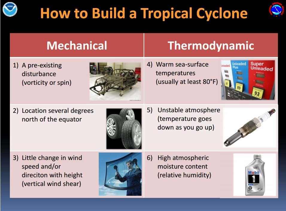
5 Tropical Cyclone Hazards


6 Tropical Cyclone Classifications Tropical Depression Tropical Storm Hurricane Sub-Tropical Storm, Extratropical Storm, Post-Tropical Storm
7

8

9
10

11
12


13 Hurricanes Come In All Sizes FLOYD VS. ANDREW -- A SIZE COMPARISON Larger storms will generate hazardous conditions over a much greater area

14


15 Storm Surge

16 Storm surge is an abnormal rise of water generated by a storm, over and above the astronomical tides. Storm surge should not be confused with storm tide, which is defined as the water level rise due to the combination of storm surge and the astronomical tide. This rise in water level can cause extreme flooding in coastal areas particularly when storm surge coincides with normal high tide, resulting in storm tides reaching up to 20 feet or more in some cases.

17 Debunking the Myth: Surge Height Connected to Storm Category Cat. 3 Katrina: 27 ft Cat. 2 IKE: 20 ft Cat. 4 Charley: 7 ft


18 Factors Affecting Storm Surge Intensity (wind speed) Forward Speed Angle of Approach Size - Radius of Maximum Winds (RMW) Width and Slope of Shelf Local features concavity of coastlines, bays, rivers, headlands, or islands


19 Storm Surge Model Map


20 Know Your Zone

21 Storm Surge Inundation Map (NHC) will issue the Potential Storm Surge Flooding Map for areas along the Gulf and Atlantic coasts of the United States at risk of storm surge from a tropical cyclone. This new map will show: Geographical areas where inundation from storm surge could occur. How high above ground the water could reach in those areas. Here are some things to know about this map: The map shows inundation levels that have a 10% chance of being exceeded, and can be though of as representing a reasonable worst-case scenario. The map is subject to change every 6 hours with every new NHC advisory. Due to processing time required to produce the map, it may not be available until minutes after the advisory release. Available as an interactive image for GIS exportable data (able to be uploaded into GATOR) possibly available for 2015.


22 Waves and Rip Currents 6 deaths in 2010 & 2012 Hidden danger because it can occur when a storm is well offshore Swells from a large hurricane can affect the beaches of the entire western Atlantic
 spawned at")

: 141 Hurricane Ivan (2004): 117")
: 90 Hurricane Camille (1969): 80")
23 Hurricane-Induced Tornadoes Nearly 70% of landfalling hurricanes ( ) spawned at least 1 tornado 40% of landfalling hurricanes spawn more than 3 tornadoes Some hurricanes produce tornado outbreaks Hurricane Beulah (1967): 141 Hurricane Ivan (2004): 117 Hurricane Frances (2004): 101 Hurricane Rita (2005): 90 Hurricane Camille (1969): 80 Hurricane Katrina (2005): 43

24 Where Do Most Tornadoes Occur? Tornadoes with hurricanes: Friction with land creates low-level wind conditions favorable for the development of tornadoes More than 90% of all tornadoes occur in the right front quadrant of the storm relative to the storm motion Most develop more than 100 miles away from the center of the storm Low Tornado Threat Lowest Tornado Threat Greatest Tornado Threat Moderate Tornado Threat


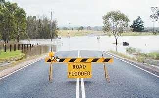


25 Floods Magnified in urban areas Boats Float, Cars Don t

26 Percentage of Significant Floods Associated With Tropical Cyclones
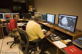
27 Hurricane Forecasting

28 Forecasting Hurricanes sparse ocean data Reconnaissance: Vital Data Satellites: GOES and QuikSCAT (OSVW) Ships and Buoys: ocean surface data Dropsondes from Reconnaissance NWS WFOs: Radar, Upper Air soundings, Local expertise Land Observations


29

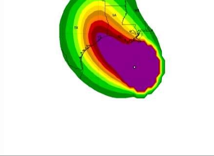
30 Katrina 5 Day Forecast Model Plots 08/24/2005 1:00 pm CDT.

31


32 Forecast Cone It s not an impact cone! Represents the probable track of the cyclone center Formed by connecting circles on each forecast point (12hr, 24, 36, etc)


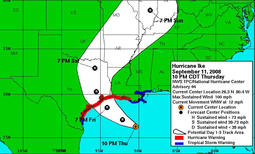

33 Impacts often occur outside the cone
34 How Does 2015 Look?


35 Total # Named Storms Tropical Storms Hurricanes Major Hurricanes Florida Landfalls ENSO phase El Niño La Niña Weak La Niña Weak La Niña - Neutral Neutral Neutral
36

37


38 Pre-Season Forecasts Named Storms Hurricanes Major Hurricanes
 & 2002 (12/4/2) were two recent prior years that featured developing El Nino conditions in the Pacific Seasonal predictions CAN T tell you where landfalls are most likely.")
39 Whether below or above normal tropical cyclones in the Atlantic Basin will always pose risks & preparedness is a must Seasonal forecast models look at similar years to make seasonal predictions 1997 (8/3/1) & 2002 (12/4/2) were two recent prior years that featured developing El Nino conditions in the Pacific Seasonal predictions CAN T tell you where landfalls are most likely. Note the differences between 2001 and 2008

40 2001 Hurricane Season 15 named storms 8 hurricanes

41 2008 Hurricane Season 16 named storms 8 hurricanes
42

43

44

45 Steering Currents are the Key
 62%(+) 85%(+) 91%(-) 66%(+) 95% 83% 62%(-)")
46 Named Storms Actual Named Hurricanes Actual Hurricanes Accuracy 51% (-) 62%(+) 85%(+) 91%(-) 66%(+) 95% 83% 62%(-) 53%(+)
47 Named Storms Actual Named Hurricanes Actual Hurricanes Accuracy 53%(-) 57%(+) 77%(+) 97% 63%(+) 89%(-) 84% 59%(-) 50%(+)


48 The Only Seasonal Forecast You Need

49 Preparedness is Key


50 A Growing Population At Risk KS +6.1% OK +8.7% TX +20.6% MO +7.0% TX +9.1% LA +1.4% VA +13.0% KY +7.4% NC TN +11.5% +18.3% SC +15.3% AL GA MS +7.5% +18.3% +4.3% Percent Change From FL +17.6% Population Density, Census 2000

51

52 What Every Floridian Needs to Know About Hurricanes It s Going to Happen, It s Just a Question of When A Hurricane is NOT a Point on the Map What are the Hurricane Hazards/Risks? What does it mean to you? What actions should you take to be prepared? Where do I get information?
53

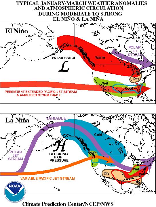
54 The Ugly Side of El Nino
55
56 Hazard Analysis Probability Frequency Severity Risk Factor Human Property Business Potential Damage Total Vulnerability Hazard (P/F)*S=RF H+P+B=PD RF/PD = V Severe Weather % Tropical Storm % Cyber Attack/Virus % Building Fire % Sick Building % Sink Holes % Hurricane - Cat 1 & % Tornado % Workplace Violence % Health Hazard/Disease % Building System Failure % Flooding % Hazmat Release % Bomb Threat % Terrorist Threat % Hurricane - Cat 3, 4, & % Lightning % Freeze % Drought % Earthquake % Tsunami % Explosion % Terrorist Event WMD % Aircraft Accident % Civil Disturbance % Nuclear Attack % SCALE SCALE Low 1 Low 1 Below Average 2 Average 2 Average 3 High 3 Above Average 4 Extensive 4 High 5 Catastrophic 5
57 COOP Level DEM COOP Activation Level SEOC/SWO Division/SEOC Timeline All Other Functions 3 Tallahassee Area Disruption to 1 or 2 essential functions or to a vital system for no more than three days. Example: Power outage, Chiller incident, small fire or moderate flood, renovations to primary facility Less than 6 hours Full SEOC Capabilities Less than 24 hours 2 Orlando / State Logistics Resource Center Disruption up to 3 or 4 essential functions or entire agency with potential of lasting more than three days. COOP activation to move staff to an alternate facility Example: Hurricane, workplace violence, major communications failure or major power outage, sick building, HAZMAT or Elevated Homeland Security Advisory System Threat Level 6-12 hours Full SEOC Capabilities Up to 72 hours 1 Camp Blanding Disruption to the entire agency with a potential for lasting at least two weeks or more Example: catastrophic event, explosion, terrorist attack, contamination of primary facility; major fire or flooding; earthquake, tsunami or Elevated Homeland Security Advisory System Threat Level 6-12 hours Full SEOC Capabilities Up to 30 days/indefinite period of time
58 COOP Level 3 CHECKLIST Phase I- Activation and Relocation COOP Activation Checklist Division/SEOC Timeline 1. Notify Relocation Team Manager and alternate facility of impending activation and relocation requirements. 2. Notify DEM staff of impending activation 3. Notify affected local, state and federal agencies( by priority) 4. Activate COOP plans to transfer to alternate facility. 5. Instruct relocation team and IMT team to deploy to get alternate site ready for staff. 6. Notify staff regarding activation of COOP plan and their status. 7. Notify vendors regarding activation of COOP plan and their status 8. Prepare for movement of documents and equipment required for primary mission essential functions at alternate site. 9. Purchase/order needed equipment/supplies. 10. Transport documents, equipment and communications. 11. Make sure primary facility is secured before departure 12. Continue mission essential functions at primary facility, if available, until alternate facility is ready. 13. Make sure primary facility is secured before departure 14. Advise alternate facility on status. 15. Deploy and Activate operations and support teams as necessary


59
Frank Revitte National Weather Service. Weather Forecast Office New Orleans/Baton Rouge
 Frank Revitte National Weather Service Weather Forecast Office New Orleans/Baton Rouge Above normal activity 17 Total Named Storms 7 Tropical Storms 4 Hurricanes 6 Major Hurricanes Not the most active,
Tropical Update. 5 AM EDT Tuesday, September 12, 2017 Post-Tropical Cyclone Irma, Hurricane Jose, & Tropical Wave (10%)
") Tropical Update 5 AM EDT Tuesday, September 12, 2017 Post-Tropical Cyclone Irma, Hurricane Jose, & Tropical Wave (10%) This update is intended for government and emergency response officials, and is provided
Tropical Update 5 AM EDT Tuesday, September 12, 2017 Post-Tropical Cyclone Irma, Hurricane Jose, & Tropical Wave (10%) This update is intended for government and emergency response officials, and is provided
2015 Hurricane Season BY: STORM TEAM 8 METEOROLOGIST JULIE PHILLIPS
 2015 Hurricane Season BY: STORM TEAM 8 METEOROLOGIST JULIE PHILLIPS FORECAST COLORADO STATE UNIVERSITY FORECAST IS CALLING FOR ONE OF THE LEAST ACTIVE SEASONS SINCE THE MID 20 TH CENTURY! THE OFFICIAL
2008 Hurricane Caravan. Daniel Noah Meteorologist National Weather Service x1 May 22, 2008
 2008 Hurricane Caravan Daniel Noah Meteorologist National Weather Service daniel.noah@noaa.gov, 813-645-2323 x1 May 22, 2008 National Weather Service We never close! Open 24 hours a day 365 days per year
Tropical Storm Harvey: SE Texas Impacts
 Tropical Storm Harvey: SE Texas Impacts 10 AM CDT UPDATE Thursday, August 24, 2017 Prepared by: Dan Reilly, Brian Kyle PLEASE MUTE YOUR LINES AND DON T PUT ON HOLD! Situation Overview Tropical Storm Harvey
Tropical Update. 5 AM EDT Monday, October 8, 2018 Tropical Storm Michael, Tropical Storm Leslie, Invest 92L (10%) & African Tropical Wave (50%)
 & African Tropical Wave (50%)") Tropical Update 5 AM EDT Monday, October 8, 2018 Tropical Storm Michael, Tropical Storm Leslie, Invest 92L (10%) & African Tropical Wave (50%) This update is intended for government and emergency response
Tropical Update 5 AM EDT Monday, October 8, 2018 Tropical Storm Michael, Tropical Storm Leslie, Invest 92L (10%) & African Tropical Wave (50%) This update is intended for government and emergency response
2017 Hurricane Season and Beyond
 2017 Hurricane Season and Beyond Ken Graham National Hurricane Center Building a Weather-Ready Nation Much of U.S. Coast Saw Tropical Wind Watches or Warnings 2017 Hurricane Season Facts and Figures 7th
Are You Ready For Hurricane Season? 2018 Hurricane Talk B Y : S T O R M T E A M 8 M E T E O R O L O G I S T J U L I E P H I L L I P S
 Are You Ready For Hurricane Season? 2018 Hurricane Talk B Y : S T O R M T E A M 8 M E T E O R O L O G I S T J U L I E P H I L L I P S About Me I am Currently a Weekday Meteorologist at WFLA Channel 8.
Tropical Update. 11 AM EDT Tuesday, October 9, 2018 Hurricane Michael, Tropical Storm Leslie, Tropical Storm Nadine
 Tropical Update 11 AM EDT Tuesday, October 9, 2018 Hurricane Michael, Tropical Storm Leslie, Tropical Storm Nadine This update is intended for government and emergency response officials, and is provided
Continuity in the Face of Hurricanes: What Every Business Needs To Know. Cameron Self, Tropical Meteorologist. StormGeo
 Continuity in the Face of Hurricanes: What Every Business Needs To Know Cameron Self, Tropical Meteorologist. StormGeo A Hurricane is a Big Heat Engine Forming over warm tropical waters, wind speeds range
Saturday, October 6, :30 a.m. EDT
 Saturday, October 6, 2018 8:30 a.m. EDT Significant Activity Oct 5-6 Significant Events: None Tropical Activity: Atlantic Tropical Storm Leslie; Disturbance 1 (High: 90%) Eastern Pacific Hurricane Sergio
HVX-HURREVAC (Beta) Webinar Series
 Webinar Series") HVX-HURREVAC (Beta) Webinar Series Day 1 - An introduction to HURREVAC and the new web-based HVX platform 2018 HVX-HURREVAC Webinar Series 1. Intro to HURREVAC and General Overview of the Program (August
HVX-HURREVAC (Beta) Webinar Series Day 1 - An introduction to HURREVAC and the new web-based HVX platform 2018 HVX-HURREVAC Webinar Series 1. Intro to HURREVAC and General Overview of the Program (August
LECTURE #18: Hurricane Damage, Monitoring & Case Study
 GEOL 0820 Ramsey Natural Disasters Spring, 2018 LECTURE #18: Hurricane Damage, Monitoring & Case Study Date: 27 March 2018 I. Exam II grades now posted online o high: 98, low: 46, average: 80 (~3 points
Ch. 11: Hurricanes. Be able to. Define what hurricane is. Identify the life and death of a hurricane. Identify the ways we track hurricanes.
 Ch. 11: Hurricanes Be able to Define what hurricane is. Identify the life and death of a hurricane. Identify the ways we track hurricanes. What are Hurricanes? Smaller than mid-latitude cyclones. Don t
Tropical Update. 5 PM EDT Thursday, September 7, 2017 Hurricane Irma, Hurricane Jose, and Hurricane Katia
 Tropical Update 5 PM EDT Thursday, September 7, 2017 Hurricane Irma, Hurricane Jose, and Hurricane Katia This update is intended for government and emergency response officials, and is provided for informational
Hurricane Readiness for Coastal Communities
 Hurricane Readiness for Participant Guide Developed for: Federal Emergency Management Agency Emergency Management Institute 16825 South Seton Avenue Emmitsburg, MD 21727-8998 Developed by: C² Technologies,
El Niño Update Impacts on Florida
 Current Issues in Emergency Management (CIEM) Sessions 1 &2 October 12 th and 26 th, 2006 Florida Division of Emergency Management Tallahassee, Florida El Niño Update Impacts on Florida Bart Hagemeyer
#FakeWeather, Cape Fear Hurricanes, and the 2018 Hurricane Season Outlook. Building a Weather-Ready Nation
 #FakeWeather, Cape Fear Hurricanes, and the 2018 Hurricane Season Outlook The #FakeWeather Epidemic #FakeWeather Expect it Before, During, & After an Event Before an event the spread of highly uncertain
NWS HURRICANES June 3, 2015
 NWS HURRICANES June 3, 2015 Hurricane Season June 1 November 30 2 What s the concern? All tropical systems passing within 125nm of central Maryland since 1950 Mid-Atlantic Hurricanes Greatest Risk: August
What s s New for 2009
 What s s New for 2009 Graphical Tropical Weather Outlook becomes operational Special Tropical Disturbance Statement replaced with Special Tropical Weather Outlook Tropical Cyclone Wind Field Graphic becomes
Tropical Update. 5 AM EDT Thursday, September 7, 2017 Hurricane Irma, Hurricane Jose, and Hurricane Katia
 Tropical Update 5 AM EDT Thursday, September 7, 2017 Hurricane Irma, Hurricane Jose, and Hurricane Katia This update is intended for government and emergency response officials, and is provided for informational
Chapter 24 Tropical Cyclones
 Chapter 24 Tropical Cyclones Tropical Weather Systems Tropical disturbance a cluster of thunderstorms about 250 to 600 km in diameter, originating in the tropics or sub-tropics Tropical depression a cluster
(April 7, 2010, Wednesday) Tropical Storms & Hurricanes Part 2
 Tropical Storms & Hurricanes Part 2") Lecture #17 (April 7, 2010, Wednesday) Tropical Storms & Hurricanes Part 2 Hurricane Katrina August 2005 All tropical cyclone tracks (1945-2006). Hurricane Formation While moving westward, tropical disturbances
Lecture #17 (April 7, 2010, Wednesday) Tropical Storms & Hurricanes Part 2 Hurricane Katrina August 2005 All tropical cyclone tracks (1945-2006). Hurricane Formation While moving westward, tropical disturbances
Tropical Update. 5 PM EDT Sunday, October 7, 2018 Tropical Storm Michael, Tropical Storm Leslie, & Invest 92L (30%)
") Tropical Update 5 PM EDT Sunday, October 7, 2018 Tropical Storm Michael, Tropical Storm Leslie, & Invest 92L (30%) This update is intended for government and emergency response officials, and is provided
Tropical Update 5 PM EDT Sunday, October 7, 2018 Tropical Storm Michael, Tropical Storm Leslie, & Invest 92L (30%) This update is intended for government and emergency response officials, and is provided
Hurricane Matthew. National Weather Service Wilmington NC. Steven Pfaff, WCM.
 Hurricane Matthew Threat Assessment for northeast South Carolina & southeast North Carolina National Weather Service Wilmington NC 730 AM EDT Tuesday October 4, 2016 Steven Pfaff, WCM Steven.Pfaff@noaa.gov
TROPICAL STORM NATE BRIEFING
 TROPICAL STORM NATE BRIEFING 2:00 PM CDT Friday, October 06, 2017 Prepared by: NWS NWSNewOrleans www.weather.gov/neworleans Situation Overview Track forecast has not changed since the 10 am advisory. Hurricane
Tropical Update. 12 PM EDT Friday, October 7, 2016 Hurricane Matthew & Tropical Storm Nicole
 Tropical Update 12 PM EDT Friday, October 7, 2016 Hurricane Matthew & Tropical Storm Nicole This update is intended for government and emergency response officials, and is provided for informational and
Natural Disasters. in Florida. Severe Thunderstorms
 Natural Disasters in Florida SC.6.E.7.7 Investigate how natural disasters have affected human life in Florida. Severe Thunderstorms While the typical afternoon thunderstorm in Florida may not appear to
The Wind Hazard: Messaging the Wind Threat & Corresponding Potential Impacts
 The Wind Hazard: Messaging the Wind Threat & Corresponding Potential Impacts Scott Spratt Warning Coordination Meteorologist NWS Melbourne, FL David Sharp Science & Operations Officer NWS Melbourne, FL
2006 & 2007 Pre-Hurricane Scenario Analyses
 2006 & 2007 Pre-Hurricane Scenario Analyses Executive Summary May 2007 Page 1 OF X FOR OFFICIAL USE ONLY 4 Public Availability to be Determined Under 5 U.S.C. 552 NOTE: Limited Distribution. Release of
Introduction to Tropical Cyclones
 Introduction to Tropical Cyclones Daniel Brown & Robbie Berg National Hurricane Center Florida Governor s Hurricane Conference 24 May 2010 Image courtesy of NASA/Goddard Space Flight Center Scientific
Agricultural Outlook Forum Presented: February 17, 2006 THE SCIENCE BEHIND THE ATLANTIC HURRICANES AND SEASONAL PREDICTIONS
 Agricultural Outlook Forum Presented: February 17, 2006 THE SCIENCE BEHIND THE ATLANTIC HURRICANES AND SEASONAL PREDICTIONS Gerald Bell Meteorologist, National Centers for Environmental Prediction NOAA,
Tropical Update. 5 PM EDT Tuesday, September 5, 2017 Hurricane Irma, Tropical Storm Jose, and Tropical Depression Thirteen
 Tropical Update 5 PM EDT Tuesday, September 5, 2017 Hurricane Irma, Tropical Storm Jose, and Tropical Depression Thirteen This update is intended for government and emergency response officials, and is
Hurricane Season 2010 & NOAA s Deepwater Response
 Hurricane Season 2010 & NOAA s Deepwater Response What s Happened? What Will 2010 Bring? Possible Shoreline Effects Darin Figurskey Meteorologist-in-Charge NOAA s NWS Raleigh, NC NOAA s National Weather
GC Briefing. Weather Sentinel Tropical Storm Michael. Status at 8 AM EDT (12 UTC) Today (NHC) Discussion. October 11, 2018
 Today (NHC) Discussion. October 11, 2018") GC Briefing Weather Sentinel Tropical Storm Michael October 11, 2018 After making landfall as a high-end category-4 hurricane on the Florida Panhandle, Michael weakened to tropical storm status early this
GC Briefing Weather Sentinel Tropical Storm Michael October 11, 2018 After making landfall as a high-end category-4 hurricane on the Florida Panhandle, Michael weakened to tropical storm status early this
TROPICAL STORM NATE BRIEFING
 TROPICAL STORM NATE BRIEFING 10:30 AM CDT Friday, October 06, 2017 Prepared by: NWS NWSNewOrleans www.weather.gov/neworleans Situation Overview Track forecast has shifted slightly eastward. Hurricane Watch
Tropical Update. 5 PM EDT Sunday, September 10, 2017 Hurricane Irma, Hurricane Jose, Tropical Wave (60%)
") Tropical Update 5 PM EDT Sunday, September 10, 2017 Hurricane Irma, Hurricane Jose, Tropical Wave (60%) This update is intended for government and emergency response officials, and is provided for informational
Tropical Update 5 PM EDT Sunday, September 10, 2017 Hurricane Irma, Hurricane Jose, Tropical Wave (60%) This update is intended for government and emergency response officials, and is provided for informational
At the Midpoint of the 2008
 At the Midpoint of the 2008 Atlantic Hurricane Season Editor s note: It has been an anxious couple of weeks for those with financial interests in either on- or offshore assets in the Gulf of Mexico and
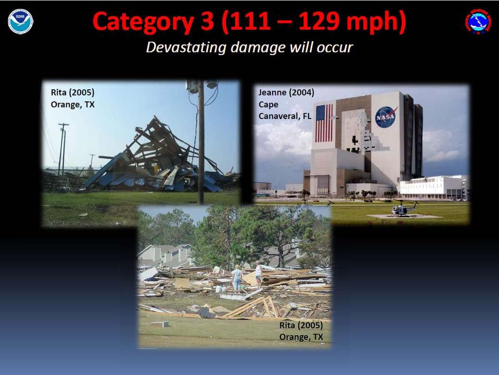
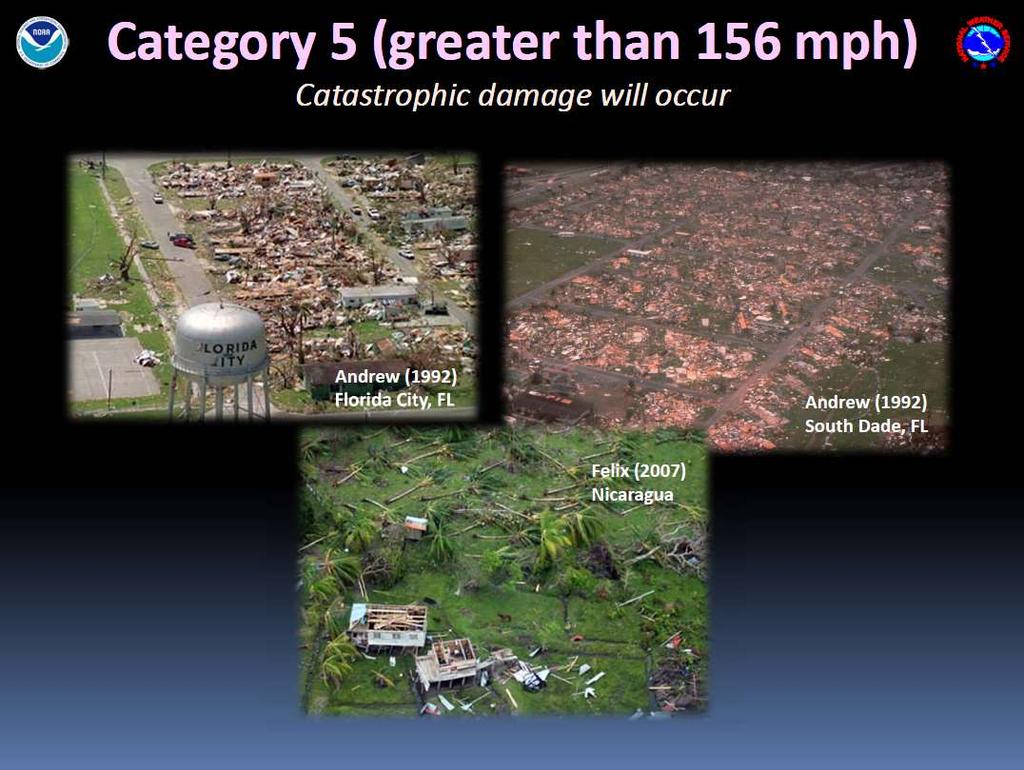
The Saffir-Simpson Hurricane Wind Scale
 The Saffir-Simpson Hurricane Wind Scale The Saffir-Simpson Hurricane Wind Scale is a one to five categorization based on the hurricane's intensity at the indicated time. The scale provides examples of
HURRICANES. Source:
 HURRICANES Source: http://www.dc.peachnet.edu/~pgore/students/w97/matheson/hpage.htm What is a hurricane? Violent cyclonic storm that develops in the tropical region Wind speeds are > 74 mph Source: http://www.google.com/imgres?hl=en&sa=x&biw=1920&bih=955&tbm=
Hurricane Charley: A Retrospective 2014 Florida Governor s Hurricane Conference
 Hurricane Charley: A Retrospective 2014 Florida Governor s Hurricane Conference 2004 Hurricane Season: Storm Tracks Satellite Images of 2004 Hurricanes Charley Frances Ivan Jeanne Three Hurricanes in Polk
Societal impacts of inland moving tropical cyclones across the southeastern U.S
 Societal impacts of inland moving tropical cyclones across the southeastern U.S Maggie M. Kovach, Gretchen Carlson, Charles E. Konrad II NOAA Southeast Regional Climate Center Department of Geography University
HURRICANE NATE BRIEFING
 HURRICANE NATE BRIEFING 2:00 PM CDT Saturday, October 07, 2017 Prepared by: NWS NWSNewOrleans www.weather.gov/neworleans Situation Overview continues to intensify. It is now forecast to be a category 2
30 If Vmax > 150, HSI intensity pts = 25
 Hurricane Severity Index: A New Way of Estimating a Tropical Cyclone s Destructive Potential 1. Introduction Christopher G. Hebert*, Robert A. Weinzapfel*, Mark A. Chambers* Impactweather, Inc., Houston,
KCC White Paper: The 100 Year Hurricane. Could it happen this year? Are insurers prepared? KAREN CLARK & COMPANY. June 2014
 KAREN CLARK & COMPANY KCC White Paper: The 100 Year Hurricane Could it happen this year? Are insurers prepared? June 2014 Copyright 2014 Karen Clark & Company The 100 Year Hurricane Page 1 2 COPLEY PLACE
TROPICAL CYCLONE TORNADOES
 TROPICAL CYCLONE TORNADOES 2018 GOVERNOR S HURRICANE CONFERENCE TUESDAY, MAY 15, 2018 WILL ULRICH NWS FORECAST OFFICE MELBOURNE WHERE ARE THE TORNADOES? WHERE ARE THE TORNADOES? C B A WEST MELBOURNE, FL
Hurricane Shelter Standards Governors Hurricane Conference 2018
 Hurricane Shelter Standards Governors Hurricane Conference 2018 Partnership with Florida Local Level State Level Hurricane Evacuation Studies Hurricane Evacuation Study Fresh Water Flooding Storm Surge
Standardizing hurricane size descriptors for broadcast to the public
 Standardizing hurricane size descriptors for broadcast to the public Lori Drake, Hurricane Roadmap Project AMS 40th Conference on Broadcast Meteorology August 22-24, 2012, Boston, MA, Operational Forecasting
TROPICAL STORM NATE BRIEFING
 TROPICAL STORM NATE BRIEFING 5:00 AM CDT Friday, October 6, 2017 Prepared by: NWS NWSNewOrleans www.weather.gov/neworleans Situation Overview No significant changes to the track forecast this morning.
Daily Operations Briefing. Monday, October 9, :30 a.m. EDT
 Daily Operations Briefing Monday, October 9, 2017 8:30 a.m. EDT Significant Activity Oct 8-9 Significant Events: Response for Hurricane Maria Tropical Activity: Atlantic Tropical Depression Seventeen Eastern
LECTURE #17: Severe Weather: Introduction to Hurricanes
 GEOL 0820 Ramsey Natural Disasters Spring, 2018 LECTURE #17: Severe Weather: Introduction to Hurricanes Date: 15 March 2018 I. Hurricane Overview hurricanes o what they are? o how they form? storm stages:
The National Hurricane Center
 The National Hurricane Center Where we are and where we hope to go Bill Read, Director National Hurricane Center U.S. HURRICANE FORECAST SERVICE HISTORY MODERN ERA HIGHLIGHTS 1935: Began 24 hour forecast
A Look Back at the 2012 Hurricane Season and a Look Ahead to 2013 & Beyond. Daniel Brown National Hurricane Center Miami, Florida 24 April 2013
 A Look Back at the 2012 Hurricane Season and a Look Ahead to 2013 & Beyond Daniel Brown National Hurricane Center Miami, Florida 24 April 2013 2012 Atlantic Verification Good News- Lots of Accuracy Records
Daily Operations Briefing. Wednesday, August 23, :30 a.m. EDT
 Daily Operations Briefing Wednesday, August 23, 2017 8:30 a.m. EDT Significant Activity August 22-23 Significant Events: Tropical Weather Threat Gulf Coast Tropical Activity: Atlantic Disturbance 1 High
GC Briefing. Weather Sentinel Hurricane Florence. Status at 5 PM EDT (21 UTC) Today (NHC) Discussion. September 13, 2018
 Today (NHC) Discussion. September 13, 2018") GC Briefing September 13, 2018 Weather Sentinel Hurricane Florence Tropical storm conditions have been reported for areas of North Carolina and will continue to spread inland to the west and south. Hurricane
GC Briefing September 13, 2018 Weather Sentinel Hurricane Florence Tropical storm conditions have been reported for areas of North Carolina and will continue to spread inland to the west and south. Hurricane
Daily Operations Briefing. Thursday, September 21, :30 a.m. EDT
 Daily Operations Briefing Thursday, September 21, 2017 8:30 a.m. EDT Significant Activity Sep 20-21 Significant Events: Response for Hurricane Maria Tropical Activity: Atlantic Tropical Storm Jose; Hurricane
Tropical Update. 5 AM EDT Wednesday, September 6, 2017 Hurricane Irma, Tropical Storm Jose, and Tropical Storm Katia
 Tropical Update 5 AM EDT Wednesday, September 6, 2017 Hurricane Irma, Tropical Storm Jose, and Tropical Storm Katia This update is intended for government and emergency response officials, and is provided
Canes on Canes: Keeping South Florida Prepared During the Calm Before the Storm. Matt Onderlinde and Pete Finocchio
 Canes on Canes: Keeping South Florida Prepared During the Calm Before the Storm Matt Onderlinde and Pete Finocchio Outline The Science of Hurricanes Why and When South Floridians Must Be Weather-Ready
SLOSH New Orleans Basin 2012 Update
 SLOSH New Orleans Basin 2012 Update Michael Koziara Science and Operations Officer National Weather Service Slidell, LA The Basics What is storm surge? What is SLOSH? Details Assumptions Inundation = Storm
Hurricane Matthew. Life Threatening Flash Flooding Likely. National Weather Service Wilmington NC. Josh Weiss, Meteorologist
 Hurricane Matthew Life Threatening Flash Flooding Likely Threat Assessment for northeast South Carolina & southeast North Carolina National Weather Service Wilmington NC 630 PM EDT Friday October 7, 2016
DYNAMIC POSITIONING CONFERENCE October 7-8, Operations. Using GIS to Understand Hurricane Windfields in the Gulf of Mexico
 Return to Session Directory DYNAMIC POSITIONING CONFERENCE October 7-8, 2008 Operations Using GIS to Understand Hurricane Windfields in the Gulf of Mexico Jill F. Hasling and Maureen T. Maiuri Weather
11/17/2017. Memorable Hurricanes of 2004 MET 4532
 MET 4532 2004 Hurricane Season Lecture 31 & 32 2004, 2005, and After 17-20 November 2017 1 2 Memorable Hurricanes of 2004 Hurricane Dates Damage (US) Deaths (US) Charlie (4) 9-14 AUG $14B 10 Ivan (4) 2-24
Environmental Geology Lab 6 Coastal Hazards. Tropical cyclones are classified based on substained wind speed as indicated below.
 Environmental Geology Lab 6 Coastal Hazards page - 1 In the continental United States there are two fundamental types of shorelines. Tectonically passive margins that have low relief and consist of smooth
Hurricanes. Environmental Geology Mr. Paul Lowrey. Stacey Singleton, Cassandra Combs, Dwight Stephenson, Matt Smithyman
 Environmental Geology Mr. Paul Lowrey Stacey Singleton, Cassandra Combs, Dwight Stephenson, Matt Smithyman Hurricanes EMPACTS Project, Spring 2017 Northwest Arkansas Community College, Bentonville, AR
TROPICAL STORM HARVEY BRIEFING
 TROPICAL STORM HARVEY BRIEFING 10:00 AM CDT Sunday, August 27, 2017 Prepared by: NWS LIX NWSNewOrleans www.weather.gov/neworleans Situation Overview New Information Tropical Storm Winds 40mph Immediate
Atlantic Basin Satellite Image
 Tropical Update 11 AM EDT Friday, September 7, 2018 Tropical Depression Gordon, Tropical Storm Florence, Potential Tropical Cyclone #8 (90%), Invest 92L (90%) This update is intended for government and
Tropical Update. 11 AM EDT Wednesday, October 10, 2018 Hurricane Michael, Hurricane Leslie & Tropical Storm Nadine, Caribbean Low (40%)
") Tropical Update 11 AM EDT Wednesday, October 10, 2018 Hurricane Michael, Hurricane Leslie & Tropical Storm Nadine, Caribbean Low (40%) This update is intended for government and emergency response officials,
Tropical Update 11 AM EDT Wednesday, October 10, 2018 Hurricane Michael, Hurricane Leslie & Tropical Storm Nadine, Caribbean Low (40%) This update is intended for government and emergency response officials,
Exercise Brunswick ALPHA 2018
 ALPHA Exercise Brunswick ALPHA 2018 Who we are (our structure) What we do (our forecasts) How you can access the information Tropical cyclone information (basic) Overview of the products used for Exercise
Tropical Update 11 AM EDT Thursday, September 6, 2018 Tropical Depression Gordon, Hurricane Florence, Invest 92L (90%) & African Tropical Wave (50%)
 & African Tropical Wave (50%)") Tropical Update 11 AM EDT Thursday, September 6, 2018 Tropical Depression Gordon, Hurricane Florence, Invest 92L (90%) & African Tropical Wave (50%) This update is intended for government and emergency
Tropical Update 11 AM EDT Thursday, September 6, 2018 Tropical Depression Gordon, Hurricane Florence, Invest 92L (90%) & African Tropical Wave (50%) This update is intended for government and emergency
Weather Research Center
 Weather Research Center 3227 Audley Houston, Texas 77098 Phone: 713-529-3076 Fax: 713-528-3538 E-mail: wrc@wxresearch.org Press Release For Immediate Release November 29, 2005 For Information Contact:
Hazardous Weather and Flooding Preparedness. Hazardous Weather and Flooding Preparedness
 Hazardous Weather and Flooding Preparedness 1 A Cooperative Effort 2 Administrative Information Emergency exits and procedures Location of restrooms Mobile devices Procedure for questions Course materials
Daily Operations Briefing. Sunday, September 24, :30 a.m. EDT
 Daily Operations Briefing Sunday, September 24, 2017 8:30 a.m. EDT Significant Activity Sep 23-24 Significant Events: Response for Hurricane Maria Tropical Activity: Atlantic Hurricane Maria (CAT 2); Hurricane
Tropical Update 6 AM EDT Friday, October 7, 2016 Hurricane Matthew & Hurricane Nicole
 Tropical Update 6 AM EDT Friday, October 7, 2016 Hurricane Matthew & Hurricane Nicole This update is intended for government and emergency response officials, and is provided for informational and situational
Tropical Cyclone Hazards. Presentation
 Tropical Cyclone Hazards Presentation Kerry N Mallory AE5JY September 7, 2011 Tropical Cyclone Hazards The Four Primary Weapons of a Tropical Cyclone are: 1. Wind 2. Storm Surge 3. Rain/Freshwater Flooding
Joseph E. Boxhorn, Ph.D., Senior Planner Southeastern Wisconsin Regional Planning Commission #
 Joseph E. Boxhorn, Ph.D., Senior Planner Southeastern Wisconsin Regional Planning Commission # 228395 Chapter I Introduction and Background Chapter II Basic Study Area Inventory and Analysis Hazard
Hurricane Wilma Post Storm Data Acquisition Estimated Peak Wind Analysis and Storm Tide Data. December 27, 2005
 Hurricane Wilma Post Storm Data Acquisition Estimated Peak Wind Analysis and Storm Tide Data December 27, 2005 Hurricane Wilma was the sixth major hurricane of the record-breaking 2005 Atlantic hurricane
Miami-Dade County Overview
 Miami-Dade County Overview 2,000 square miles World s busiest cruise port 2.6 million residents Second busiest US airport for international travelers Gateway to the Caribbean and Latin America Natural
Current Details from the National Hurricane Center (NHC)
") Current Watches/Warnings A Hurricane Warning is in effect from Surf City, North Carolina to the North Carolina/Virginia border; Pamlico Sound; Eastern Albemarle Sound A Hurricane Watch is in effect from
Current Watches/Warnings A Hurricane Warning is in effect from Surf City, North Carolina to the North Carolina/Virginia border; Pamlico Sound; Eastern Albemarle Sound A Hurricane Watch is in effect from
Hurricane Matthew Threats and Impacts Briefing for Eastern NC
 Hurricane Matthew Threats and Impacts Briefing for Eastern NC October 6 th, 2016 Date/Time Created: 10/6/2016, Noon EDT National Weather Service Newport/Morehead City, NC Hurricane Matthew Key Points Changes
HURRICANE IRENE. CONFERENCE CALL BRIEFING SLIDES Saturday August 27, :30 AM
 HURRICANE IRENE CONFERENCE CALL BRIEFING SLIDES Saturday August 27, 2011 8:30 AM NHC TRACK AND CONE HURRICANE IRENE WATCHES/WARNINGS Hurricane Warning along south coast including all of Cape Cod and Islands
Experimental Probabilistic Hurricane Inundation Surge Height (PHISH) Guidance
 Guidance") Experimental Probabilistic Hurricane Inundation Surge Height (PHISH) Guidance DRBC Flood Advisory Committee John Kuhn - NWS/OCWWS Anne Myckow (NWS/MDL), Arthur Taylor (NWS/MDL) SLOSH Sea, Lake and Overland
Experimental Probabilistic Hurricane Inundation Surge Height (PHISH) Guidance DRBC Flood Advisory Committee John Kuhn - NWS/OCWWS Anne Myckow (NWS/MDL), Arthur Taylor (NWS/MDL) SLOSH Sea, Lake and Overland
Key Takeaways: - Rain: Coastal NC: ; isolated totals to 40 Central, Western, & Northeastern NC: 5-10 ; isolated totals to 20
 Key Takeaways: - Life-Threatening Impacts Will Extend Far From The Storm s Center: Despite the southward shift in track, widespread and extreme impacts from heavy rain, storm surge, and wind are still
5.2. IDENTIFICATION OF NATURAL HAZARDS OF CONCERN
 5.2. IDENTIFICATION OF NATURAL HAZARDS OF CONCERN To provide a strong foundation for mitigation strategies considered in Sections 6 and 9, County considered a full range of natural hazards that could impact
Storm Surge Forecast with Shifting Forecast Tracks
 Storm Surge Forecast with Shifting Forecast Tracks Storm Surge Findings in the Florida Keys Jon Rizzo Warning Coordination Meteorologist National Weather Service Florida Keys Florida Keys Life History
Tuesday, September 13, 16
 Weather Weather State Objectives 4.c, 4.d, 4.h. Discussion What are some ways in which weather affects your everyday life? Discussion What are some ways in which weather affects your everyday life? What
HURRICANE FRANCES CHARACTERISTICS and STORM TIDE EVALUATION
 HURRICANE FRANCES CHARACTERISTICS and STORM TIDE EVALUATION ((DRAFT)) By Robert Wang and Michael Manausa Sponsored by Florida Department of Environmental Protection, Bureau of Beaches and Coastal Systems
Tropical Storm Colin Briefing Last Briefing on this System
 Tropical Storm Colin Briefing Last Briefing on this System NWS WFO Jacksonville, Florida Tuesday, June 07, 2016 6:00 a.m. EDT Tropical Storm Colin s Impacts SE Georgia & North Florida Local Watches & Warnings:
Outlook 2008 Atlantic Hurricane Season. Kevin Lipton, Ingrid Amberger National Weather Service Albany, New York
 Outlook 2008 Atlantic Hurricane Season Kevin Lipton, Ingrid Amberger National Weather Service Albany, New York Summary 2007 Hurricane Season Two hurricanes made landfall in the Atlantic Basin at category-5
Tropical Storm Ana. Created 6:00 AM Sun May 10, 2015 John Cole Warning Coordination Meteorologist
 Tropical Storm Ana Threat Assessment for Eastern North Carolina Created 6:00 AM Sun May 10, 2015 John Cole Warning Coordination Meteorologist John.cole@noaa.gov National Weather Service Newport/Morehead
Weather Middle School Teacher Instructions and Activity
 Weather Middle School Teacher Instructions and Activity Based on the guidelines of the Saffir-Simpson Scale for hurricane severity and the Fujita Scale for tornado damage, students will write a brief synopsis
Canadian Hurricane Center: How NHC Products are used to issue Warnings and Communicate Hazards
 Canadian Hurricane Center: How NHC Products are used to issue Warnings and Communicate Hazards Bob Robichaud Warning Preparedness Meteorologist Canadian Hurricane Centre Contents Brief background on the
Hurricane Matthew Life Threatening Flash Flooding Likely
 Hurricane Matthew Life Threatening Flash Flooding Likely Threat Assessment for northeast South Carolina & southeast North Carolina National Weather Service Wilmington NC 12 AM EDT Saturday October 8, 2016
National Weather Service. Building a Weather Ready Nation
 National Weather Service Building a Weather Ready Nation The NWS is a federal agency Department of Commerce National Oceanic and Atmospheric Administration National Weather Service Today s National Weather
Monday, October 8, :30 a.m. EDT
 Monday, October 8, 2018 8:30 a.m. EDT Significant Activity Oct 7-8 Significant Events: Tropical Storm Michael Preparation Tropical Activity: Atlantic Tropical Storm Leslie; Tropical Storm Michael; Disturbance
PRMS WHITE PAPER 2014 NORTH ATLANTIC HURRICANE SEASON OUTLOOK. June RMS Event Response
 PRMS WHITE PAPER 2014 NORTH ATLANTIC HURRICANE SEASON OUTLOOK June 2014 - RMS Event Response 2014 SEASON OUTLOOK The 2013 North Atlantic hurricane season saw the fewest hurricanes in the Atlantic Basin
Daily Operations Briefing Wednesday, May 27, :30 a.m. EDT
 Daily Operations Briefing Wednesday, May 27, 2015 8:30 a.m. EDT Significant Activity May 26 27 Significant Events: Flooding/Severe Weather Southern Plains Tropical Activity: Atlantic Tropical cyclone activity
Hurricane Harvey: SE Texas Impacts. 10 PM CDT UPDATE Friday, August 25, 2017 Prepared by: Lance Wood
 Hurricane Harvey: SE Texas Impacts 10 PM CDT UPDATE Friday, August 25, 2017 Prepared by: Lance Wood Latest Observations Hurricane Harvey making landfall this evening near Rockport as a category 4 hurricane.
Hurricane Preparedness and Awareness!
 Hurricane Preparedness and Awareness! Check these out Time to begin executing the evacuation plan What kind of damage are we talking about here? What Exactly Is a Hurricane? A hurricane can best be described
HURRICANE HARVEY COE Navigation BRIEFING
 HURRICANE HARVEY COE Navigation BRIEFING 10:00 AM CDT Friday, August 25, 2017 NWSNewOrleans www.weather.gov/neworleans Situation Overview New Information Harvey continues to strengthen Max sustained winds
Florida Statewide Regional Evacuation Study Program
 Florida Statewide Regional Evacuation Study Program Directional Atlas Lafayette County Volume 10-3 Book 4 Florida Division of Emergency Management North Central Florida Regional Planning Council North