Annual Meeting Luncheon
|
|
|
- Annabella O’Neal’
- 5 years ago
- Views:
Transcription

1 Annual Meeting Luncheon MCEER s s Post-Hurricane Katrina Reconnaissance Investigations Featured Speakers Gilberto Mosqueda, University at Buffalo Lucy Arendt, University of Wisconsin-Green Bay Ryan Shannon, Tulane University
2 Hurricane Katrina Made landfall on August 29, 2005 at 7:10 AM near Louisiana-Mississippi border Category 3 hurricane with sustained winds of 125 MPH, storm surges up to 28 ft., and strong winds up to 100 miles away from it center Most destructive and costly disaster in US history Multihazard event: wind, storm surge, and flooding Background photo credit: NOAA

3 Hurricane Katrina Saffir-Simpson Hurricane Intensity Scale (ASCE 2005) Category Wind speed (mph) >155 Barometric Pressure (in) <27.17 Storm surge (ft) >18 Level of damage minimal moderate extensive extreme catastrophic Background photo credit: NOAA
")

4 Katrina s s Path and Wind Speed (Wind speed below design level) New Orleans ~100 MPH Mobile, AL ~80 MPH Max ~125 MPH Figure credit: NOAA
 Ramp Bridge US-90 to I-10 EB Baldwin County, AL just East of Mobile, AL")
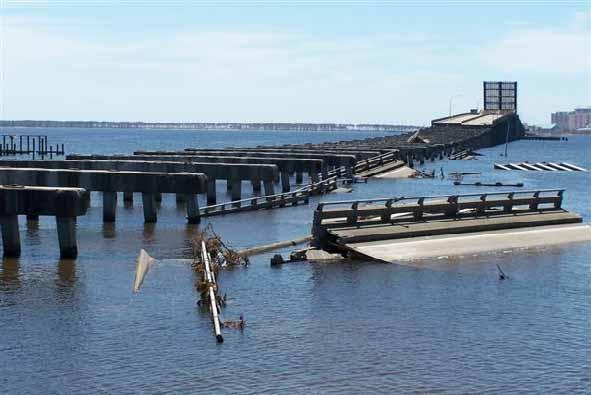
5 Storm surge along Gulf Coast US90 to I-10EB I Ramp Bridge Baldwin County, Alabama (Just East of Mobile) Ramp Bridge US-90 to I-10 EB Baldwin County, AL just East of Mobile, AL

6 New Orleans flooding Major levee breaches in 3 canals 80 sq mi, 250,000 acre-feet of water Photo Credit: USGS/EROS
7 MCEER Reconnaissance Objectives Assess damage to built environment and emergency response and recovery from a multi-hazard perspective Examine lessons learned and their application to disaster mitigation for other extreme events (earthquakes, terrorist attack) Extent of damage required multidisciplinary investigations; teams with various expertise were deployed
8 Multidisciplinary Investigations Remote Sensing Shubharoop Ghosh, ImageCat, Inc. Carol Hill, Louisiana State University Arn Womble, Texas Tech University Damage to Buildings, Bridges, and Lifelines Paul McAnany, Practicing Engineer Gilberto Mosqueda, University at Buffalo Jerome S. O Connor, MCEER Keith A. Porter, California Institute of Technology Planning, Response and Recovery of Critical Facilities Lucy Arendt, University of Wisconsin Daniel Hess, University at Buffalo Environmental and Public Health Issues James Jensen, University at Buffalo Pavani Ram, University at Buffalo

9 Areas of Investigation 100 miles Katrina s Path
10 MCEER Reconnaissance of Mississippi and Alabama Teams deployed Sept to Mississippi and Alabama Remote sensing Structural investigations Teams deployed Oct. 3-9, Oct to New Orleans Remote sensing Structural damage investigations Response of hospitals, transportation systems and other critical facilities Environmental and public health issues

11 Rapid Dissemination - Web Reports Posted from Field

12 Technical reports available
13 Remote Sensing Use remote sensing technologies and the VIEWS TM reconnaissance system in post Katrina urban damage assessment Wind, storm surge, flooding and levee breach Use in-field observations to correlate and validate nature and extent of damage detected from Satellite images

14 Overview of Post-Katrina Remote Sensing Data Photo Credit: NOAA
15 Overview of Post-Katrina Remote Sensing Data Photo Credit: NOAA

16 1. Storm Surge Effects Photo Credit: NOAA Surge line Extreme damage


17 2. Flood Inundation Damage Rapid airborne mapping using VIEWS TM Flood status August 30 th Extreme Moderate Low or none Satellite image-based Flood line delineation Flood status Sept 3rd 2005 Boundary of Extreme flooding
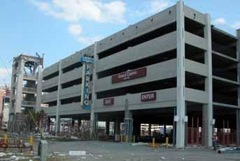
18 3. Inundation damage adjacent to levee breach Photo Credit: NOAA 17 th street canal levee breach No flooding Flooding


19 4. Wind Damage Effects Windspeed Estimate: mph (sustained at 10m) BEFORE Aerial image courtesy: NOAA AFTER

20 VIEWS TM and Google Earth VIEWS/ GOOGLE EARTH
21 Structural Damage Investigations Examine damage to large engineered structures, primarily bridges and commercial buildings Assess structural damage from a multihazard perspective; similarities to other hazards Identify potential applications of seismic design principles to mitigate hurricane damage


22 US 90 Eastbound Pass Christian to Bay St. Louis, Mississippi

23 Bridges Biloxi Bay CSX Railroad Pedestrian Bridge US-90 N
24 Bridges

25 Railroad bridge over Biloxi Bay

26 U.S. Gulf Coast Major Bridge Damage


27 Collapse of Parking Structures Due to Storm Surge

28 Some parking structures performed well

29 Partial collapse of parking structures in Biloxi Partial collapse storm surge Partial collapse impact No structural damage Internet Map Server Art Lembo, Cornell

30 Buildings in Downtown Gulfport Few collapsed unreinforced masonry structures Most engineered buildings suffered only nonstructural damage Rain and wind penetrated building interior through broken windows


31 Gulfport Coastal Hotels Significant nonstructural damage to building exterior and interior


32 Partial Collapse of Building Due to Barge Impact Impact


33 Glazing damage to downtown New Orleans office buildings
34 Preliminary Lessons Learned: Structural Damage Structural damage caused by storm surge and surge-borne debris (casino barges) Storm surge damaged mainly precast concrete structures: bridges and parking structures Significant nonstructural glazing damage occurred to structures that were downwind of gravel roofs due to wind and wind-borne debris Additional damage in building interior Backup systems located in basement were damaged by flooding

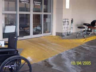
35 Multihazard aspects: Structural damage Similar losses occur in earthquakes & hurricanes importance of nonstructural elements Precast bridges and parking structures had similar failure in past earthquakes Photo Credit: Los Angeles Times Seismic resistant details have been developed for precast construction and may be useful for storm surge resistant design
36 Multihazard aspects: Overall Combined disasters Hurricane Katrina followed by flooding destroyed New Orleans In 1906 San Francisco Earthquake ground shaking followed by fires destroyed San Francisco Need to consider multiple hazards in enhancing resilience of communities

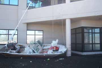
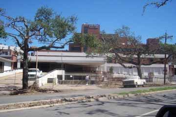
37 Hospitals in New Orleans
38 Why study hospitals? People expect hospitals to withstand all natural disasters, including floods, hurricanes, blizzards, and earthquakes. People expect hospitals to respond when their community faces nuclear, industrial, transportation, or other manmade disasters (e.g., terrorism). Hospitals merit special attention thanks to their complexity and occupancy characteristics, and because of their role during disasters.
39

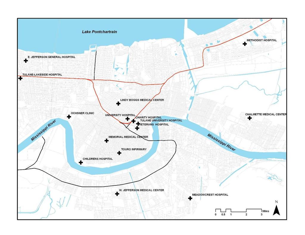
40 Disaster Preparedness & Response Hospitals prepared and performed well during the Hurricane, but were shocked by the widespread flooding that followed.

41 The View from Methodist Hospital

42 Inside Methodist Hospital

43 Disaster Preparedness & Response Location, location, location
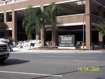
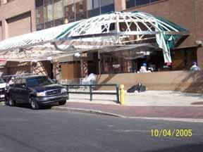
44 The Aftermath After days without communication and outside support, food, medication, power and potable water ran out hospitals turned from emergency responders to victims.

45 Paradigm Shift
46 The Aftermath Hospitals evacuated after their ability to deliver quality healthcare became compromised.

47 Evacuating Methodist Hospital

48 Evacuating Memorial Hospital
49 The Aftermath Chalmette Medical Center (St. Bernard Parish) Lindy Boggs Medical Center (Mercy) Charity/University Hospital Memorial Medical Center (Baptist) Methodist Hospital Tulane University Hospital reopened 2/14/06 VA Hospital

50 Chalmette Medical Center

51 Lindy Boggs


52 Charity Hospital

53 Memorial Medical Center
54 Tulane University Hospital


55 VA Hospital
56 The Aftermath Children s Hospital Touro Infirmary Tulane-Lakeside East Jefferson General Hospital Ochsner Clinic Foundation West Jefferson Medical Center Meadowcrest Hospital


57 Touro Infirmary
58 Preliminary Lessons Learned: Hospitals Constructing Resilient Building Systems: Hospitals should have their own power and water supplies independent of municipal utilities. Expecting To Be Self-Sufficient: Hospitals should expect to be on their own in the event of an emergency. Networking: Hospital staff members should build strong networks with local, regional, state, and national sources of assistance (both governmental and private).
59 Preliminary Lessons Learned: Hospitals Staffing: Hospitals should continue to hire the best staff members and be certain that those staff members are on site when needed. Communicating Emergency Plans: Hospitals should plan for the worst and be certain that all staff members know their role in an emergency. Leading Effectively: Having planned for the worst, hospital executives should be poised to lead.
60 Hospital Recovery Negative Media Attention Re-Establishing a Healthcare System Hospital Staffing
61 New Orleans Today
62 Acknowledgements National Science Foundation ImageCat, Inc. Michel Bruneau, Andre Filiatrault, Jane Stoyle, David Parisi, Michelle Zuppa, MCEER Headquarters
63 Thank you! More information available at
Report on the Damage Survey Caused by Hurricane Katrina (Tentative Report)
") Report on the Damage Survey Caused by Hurricane Katrina (Tentative Report) November 1, 2005 Coastal Disaster Prevention Technology Survey Team 1. Introduction Hurricane Katrina struck the United States
Report on the Damage Survey Caused by Hurricane Katrina (Tentative Report) November 1, 2005 Coastal Disaster Prevention Technology Survey Team 1. Introduction Hurricane Katrina struck the United States
A Utility s Response and Recovery. Marc Butts Southern Company 03/19/2014
 A Utility s Response and Recovery Marc Butts Southern Company 03/19/2014 Service territory across four states: 120,000 square miles Serves approximately 4 million customers Other Subsidiaries: Southern
Typhoon Maemi and Hurricane Katrina: Impacts and Aftermath. Typhoon Maemi: September 13, Typhoon Maemi Track and Characteristics
 Typhoon Maemi and Hurricane Katrina: Impacts and Aftermath Pierre Julien Un Ji Department of Civil Engineering Colorado State University Fort Collins, Colorado USA September, 2005 Typhoon Maemi: September
Hurricane Katrina and Oil Spills: Impact on Coastal and Ocean Environments
 Archived version from NCDOCKS Institutional Repository http://libres.uncg.edu/ir/asu/ Pine, J. C. (June 2006). Hurricane Katrina and oil spills: Impact on coastal and ocean environments. Oceanography,
A HURRICANE IS COMING. Presented by Atiba Upchurch Broward Emergency Management Division
 A HURRICANE IS COMING Presented by Atiba Upchurch Broward Emergency Management Division Mission Statement To safeguard the lives and property of the people of Broward County from major hazards and emergencies
Coastal Resiliency: Planning for Natural Variability and Recovering from Extreme Events
 Coastal Resiliency: Planning for Natural Variability and Recovering from Extreme Events Stephanie Showalter, J.D., M.S.E.L. Director, National Sea Grant Law Center University of Mississippi Coastal Hazards
Using Remote Sensing Technologies to Improve Resilience
 4 Using Remote Sensing Technologies to Improve Resilience Ronald T. Eguchi CEO, ImageCat, Inc. 6 years ago The world had just survived the Y2K bug with no major incidents Nations around the world commit
National Situation Report As of 3:00 a.m. EDT, Sunday, October 8, 2017 Table of Contents Current Operations Monitoring Recovery
 Overview National Situation Report As of 3:00 a.m. EDT, Sunday, October 8, 2017 Table of Contents Current Operations Monitoring Recovery FEMA Headquarters Status FEMA Region Status NRCC Level I (24/7)
Hurricanes and Storm Surge : Before coming to lab, visit the following web site:
 Geol 108 Lab #7 Week of October 15-19, 2012 Coastal Studies Hurricanes and Storm Surge : Before coming to lab, visit the following web site: http://www.usatoday.com/graphics/weather/gra/gsurge/flash.htm
3Chapter Three: Rescue and Response
 17 16 Report Science Title and the Storms: the USGS Response to the Hurricanes of 2005 3Chapter Three: Rescue and Response This chapter documents the U.S. Geological Survey s (USGS) humanitarian rescue
MODELLING CATASTROPHIC COASTAL FLOOD RISKS AROUND THE WORLD
 MODELLING CATASTROPHIC COASTAL FLOOD RISKS AROUND THE WORLD Nicola Howe Christopher Thomas Copyright 2016 Risk Management Solutions, Inc. All Rights Reserved. June 27, 2016 1 OUTLINE MOTIVATION What we
PART 4 HURRICANE KATRINA STRIKES NEW ORLEANS AUGUST 2005
 PART 4 HURRICANE KATRINA STRIKES NEW ORLEANS AUGUST 2005 Hurricane Katrina Hurricane Katrina swept across southern Florida and lost momentum, then gained speed and water, showing the second lowest barometric
Welcome Jeff Orrock Warning Coordination Meteorologist National Weather Service Raleigh
 Welcome Jeff Orrock Warning Coordination Meteorologist National Weather Service Raleigh Jeff.orrock@noaa.gov Sources: Operational Significant Event Imagery and the Environmental Applications Team (EAT)
Daily Operations Briefing. Sunday, October 8, :30 a.m. EDT
 Daily Operations Briefing Sunday, October 8, 2017 8:30 a.m. EDT Significant Activity Oct 7-8 Significant Events: Response for Hurricane Maria Preparations/Response for Hurricane Nate Tropical Activity:
Fort Lauderdale s GIS Supports Response to. Hurricane Irma
 Fort Lauderdale s GIS Supports Response to Hurricane Irma By Monica Pratt, ArcUser Editor When Hurricane Irma first made landfall in the Florida Keys on September 10, 2017, it brought destructive 70 mph
The Saffir-Simpson Hurricane Wind Scale
 The Saffir-Simpson Hurricane Wind Scale The Saffir-Simpson Hurricane Wind Scale is a one to five categorization based on the hurricane's intensity at the indicated time. The scale provides examples of
HURRICANE MARIA PUERTO RICO ASSESSMENT FOUR & SIX MONTHS POST LANDFALL. January & March 2018
 HURRICANE MARIA PUERTO RICO ASSESSMENT FOUR & SIX MONTHS POST LANDFALL January & March 2018 CONCLUSIONS OF FIELD RECON JANUARY AND MARCH 2018 JLT Re conducted an island wide damage survey four month after
Hurricane Tracking Lab
 Hurricane Tracking Lab Background: Hurricanes are one of nature s most powerful disasters. To equal the power of a hurricane, one would have to set off about a thousand nuclear devices per second for as
Comparative Analysis of Hurricane Vulnerability in New Orleans and Baton Rouge. Dr. Marc Levitan LSU Hurricane Center. April 2003
 Comparative Analysis of Hurricane Vulnerability in New Orleans and Baton Rouge Dr. Marc Levitan LSU Hurricane Center April 2003 In order to compare hurricane vulnerability of facilities located in different
Ahead of the Wave: The Change Coming to the Saffir-Simpson
 Ahead of the Wave: The Change Coming to the Saffir-Simpson Classification System Editor s note: In 2009, the National Hurricane Center announced that it was updating the Saffir-Simpson Hurricane Scale
The Tampa Bay Catastrophic Plan Presentation to CFGIS Users Group FDOT District 5 Urban Offices - Orlando July 30, 2010
 The Tampa Bay Catastrophic Plan Presentation to CFGIS Users Group FDOT District 5 Urban Offices - Orlando July 30, 2010 Brady Smith Senior Planner Tampa Bay Regional Planning Council Introduction Recent
Friday, August 31, :30 a.m. EDT
 Friday, August 31, 2018 8:30 a.m. EDT Significant Activity Aug 30-31 Significant Events: Flooding Wisconsin Tropical Activity: Atlantic Potential Tropical Cyclone Six High (90%); Disturbance 1: Low (10%)
Saturday, October 6, :30 a.m. EDT
 Saturday, October 6, 2018 8:30 a.m. EDT Significant Activity Oct 5-6 Significant Events: None Tropical Activity: Atlantic Tropical Storm Leslie; Disturbance 1 (High: 90%) Eastern Pacific Hurricane Sergio
Weather Middle School Teacher Instructions and Activity
 Weather Middle School Teacher Instructions and Activity Based on the guidelines of the Saffir-Simpson Scale for hurricane severity and the Fujita Scale for tornado damage, students will write a brief synopsis
Major Hurricane Matthew Briefing Situation Overview
 Major Hurricane Matthew Briefing Situation Overview THIS IS NOW A WORST CASE STORM SURGE SCENARIO Catastrophic Damage is Anticipated for Coastal Areas. Major Hurricane Matthew is still expected to move
HAZUS-MH: Earthquake Event Report
 HAZUS-MH: Earthquake Event Report Region Name: El Paso County Earthquake Scenario: El Paso County Random EQ Print Date: February 08, 2006 Disclaimer: The estimates of social and economic impacts contained
2006 & 2007 Pre-Hurricane Scenario Analyses
 2006 & 2007 Pre-Hurricane Scenario Analyses Executive Summary May 2007 Page 1 OF X FOR OFFICIAL USE ONLY 4 Public Availability to be Determined Under 5 U.S.C. 552 NOTE: Limited Distribution. Release of
Daily Operations Briefing. Monday, October 9, :30 a.m. EDT
 Daily Operations Briefing Monday, October 9, 2017 8:30 a.m. EDT Significant Activity Oct 8-9 Significant Events: Response for Hurricane Maria Tropical Activity: Atlantic Tropical Depression Seventeen Eastern
M-8.1 EARTHQUAKE 87KM SW OF PIJIJIAPAN, MEXICO EXACT LOCATION: N W DEPTH: 69.7KM SEPTEMBER 7, 11:49 PST
 M-8.1 EARTHQUAKE 87KM SW OF PIJIJIAPAN, MEXICO EXACT LOCATION: 15.068 N 93.715 W DEPTH: 69.7KM SEPTEMBER 7, 2017 @ 11:49 PST Photo: Luis Alberto Cruz / AP Photo: Carlos Jasso 1 THE 2017 CHIAPAS MEXICO
2008 Hurricane Caravan. Daniel Noah Meteorologist National Weather Service x1 May 22, 2008
 2008 Hurricane Caravan Daniel Noah Meteorologist National Weather Service daniel.noah@noaa.gov, 813-645-2323 x1 May 22, 2008 National Weather Service We never close! Open 24 hours a day 365 days per year
Chapter 16, Part Hurricane Paths. 2. Hurricane Paths. Hurricane Paths and Damage
 Chapter 16, Part 2 Hurricane Paths and Damage 1. Hurricane Paths Start over tropical water except South Atlantic and eastern South Atlantic, where water is too cold. Initially steered by easterly winds
Hurricane Protection and Environmental Restoration
 November 16, 2010 Hurricane Protection and Environmental Restoration Presented by: Colonel (Ret.) Leonard Waterworth AGENDA How do we protect People/Environment/Economy 1900 Year Storm Hurricane Carla
HURRICANES. Source:
 HURRICANES Source: http://www.dc.peachnet.edu/~pgore/students/w97/matheson/hpage.htm What is a hurricane? Violent cyclonic storm that develops in the tropical region Wind speeds are > 74 mph Source: http://www.google.com/imgres?hl=en&sa=x&biw=1920&bih=955&tbm=
HAZUS-MH: A Predictable Hurricane Risk Assessment Tool for the City of Houston and Harris County
 HAZUS-MH: A Predictable Hurricane Risk Assessment Tool for the City of Houston and Harris County Presented by Melvin G. Spinks, P.E., President Annie Ding, PhD, GISP October 29, 2008 Rice University Contents
Hurricanes. Cause: a low pressure storm system over warm ocean water. Effect: potential massive widespread destruction and flooding.
 Hurricanes Hurricanes Cause: a low pressure storm system over warm ocean water. Effect: potential massive widespread destruction and flooding. Hurricanes also known as: cyclone (Indian Ocean) or typhoon
Business Preparedness. Hurricane Preparedness 2018 NFP InForum February 15, 2018
 Business Preparedness Hurricane Preparedness 2018 NFP InForum February 15, 2018 Agenda Past Experience Hugo Floyd Matthew Irma Hurricane Tabletop Exercise Pre-Landfall Post-Landfall (1 day and 10 days)
Hazard Vulnerability Analysis (HVA)
") Hazard Vulnerability Analysis (HVA) What is an HVA Systematic approach to recognizing hazards that may effect the ability to care for residents The risks associated with each hazard are analyzed to prioritize
Hazard Vulnerability Analysis (HVA) What is an HVA Systematic approach to recognizing hazards that may effect the ability to care for residents The risks associated with each hazard are analyzed to prioritize
Pacific Catastrophe Risk Assessment And Financing Initiative
 Pacific Catastrophe Risk Assessment And Financing Initiative TUVALU is expected to incur, on average,. million USD per year in losses due to earthquakes and tropical cyclones. In the next 5 years, has
Superstorm Sandy What Risk Managers and Underwriters Learned
 Superstorm Sandy What Risk Managers and Underwriters Learned Gary Ladman Vice President, Property Underwriting AEGIS Insurance Services, Inc. Superstorm Sandy Change in the Weather Recent years appears
Response Case Study: April 2014 Historic Flood Event. Severe Weather April 29 30, 2014
 Response Case Study: April 2014 Historic Flood Event NOAA s Regional Preparedness Training (NRPT) Natural Disaster Causing Technology Disasters in Mobile Bay Area Kimberly Albins Gulf of Mexico Regional
Residential building damage from hurricane storm surge: proposed methodologies to describe, assess and model building damage
 Louisiana State University LSU Digital Commons LSU Doctoral Dissertations Graduate School 2009 Residential building damage from hurricane storm surge: proposed methodologies to describe, assess and model
Wind Engineering Research at UIUC
 Wind Engineering Research at UIUC Franklin T. Lombardo (and students) Assistant Professor University of Illinois at Urbana-Champaign Department of Civil and Environmental Engineering THE Conference Illini
M 7.1 EARTHQUAKE 5KM ENE OF RABOSO, MEXICO EXACT LOCATION: N W DEPTH: 51.0KM SEPTEMBER 19, 1:14 LOCAL TIME
 M 7.1 EARTHQUAKE 5KM ENE OF RABOSO, MEXICO EXACT LOCATION: 18.584 N 98.399 W DEPTH: 51.0KM SEPTEMBER 19, 2017 @ 1:14 LOCAL TIME Photo: Eduardo Verdugo / AP Photo: Alfredo Estrella/ Agence France-Presse/
Daily Operations Briefing. Wednesday, September 27, :30 a.m. EDT
 Daily Operations Briefing Wednesday, September 27, 2017 8:30 a.m. EDT Significant Activity Sep 26-27 Significant Events: Response for Hurricane Maria Tropical Activity: Atlantic Tropical Storm Maria; Hurricane
Pacific Catastrophe Risk Assessment And Financing Initiative
 Pacific Catastrophe Risk Assessment And Financing Initiative PALAU September is expected to incur, on average,.7 million USD per year in losses due to earthquakes and tropical cyclones. In the next 5 years,
Advanced Image Analysis in Disaster Response
 Advanced Image Analysis in Disaster Response Creating Geographic Knowledge Thomas Harris ITT The information contained in this document pertains to software products and services that are subject to the
Jefferson Parish GIS Hurricane Response Review. From the information given by A.J. Tapie, GIS Manager of Jefferson Parish, the use of
 Neil Dixon and Ryan Ziegelbauer URPL 969 3/10/2006 Jefferson Parish GIS Hurricane Response Review From the information given by A.J. Tapie, GIS Manager of Jefferson Parish, the use of GIS in the Parish
HURRICANE IVAN CHARACTERISTICS and STORM TIDE EVALUATION
 HURRICANE IVAN CHARACTERISTICS and STORM TIDE EVALUATION By Robert Wang and Michael Manausa Sponsored by Florida Department of Environmental Protection, Bureau of Beaches and Coastal Systems Submitted
Hurricane Preparedness and Awareness!
 Hurricane Preparedness and Awareness! Check these out Time to begin executing the evacuation plan What kind of damage are we talking about here? What Exactly Is a Hurricane? A hurricane can best be described
Daily Operations Briefing. Friday, October 6, :30 a.m. EDT
 Daily Operations Briefing Friday, October 6, 2017 8:30 a.m. EDT Significant Activity Oct 5-6 Significant Events: Response for Hurricane Maria, Preparations for Tropical Storm Nate Tropical Activity: Atlantic
Hurricane Tracks. Isaac versus previous storms Impacts and solutions. ( Continue by clicking on the slide bar to the right)
") Hurricane Tracks Isaac versus previous storms Impacts and solutions ( Continue by clicking on the slide bar to the right) 1 Hurricane Tracks 2 Sample Hurricanes The sample hurricanes selected were chosen
Hurricane Tracks Isaac versus previous storms Impacts and solutions ( Continue by clicking on the slide bar to the right) 1 Hurricane Tracks 2 Sample Hurricanes The sample hurricanes selected were chosen
AN ENGINEERING ANALYSIS OF THE GRAND ISLAND, NE TORNADOES
 (Presented at the 12th Conf. on Severe Local Storms, San Antonio, Texas, January 1982, p. 293-296). AN ENGINEERING ANALYSIS OF THE GRAND ISLAND, NE TORNADOES Timothy P. Marshall and James R. McDonald Institute
4Chapter Four: How Technology Helps
 63 Report Title 62 Science and the Storms: the USGS Response to the Hurricanes of 2005 4Chapter Four: How Technology Helps Technology in many forms enables U.S. Geological Survey scientists to assess conditions
CATEX Hurricane Zachary
 CATEX Hurricane Zachary EXERCISE, EXERCISE,EXERCISE East Coast CATEX Power Restoration Functional Exercise 2013 This document was prepared under a grant from FEMA's Grants Programs Directorate, U.S. Department
GC Briefing. Weather Sentinel Tropical Storm Michael. Status at 8 AM EDT (12 UTC) Today (NHC) Discussion. October 11, 2018
 Today (NHC) Discussion. October 11, 2018") GC Briefing Weather Sentinel Tropical Storm Michael October 11, 2018 After making landfall as a high-end category-4 hurricane on the Florida Panhandle, Michael weakened to tropical storm status early this
GC Briefing Weather Sentinel Tropical Storm Michael October 11, 2018 After making landfall as a high-end category-4 hurricane on the Florida Panhandle, Michael weakened to tropical storm status early this
Parish of Ascension. ASCENSION PARISH SITUATIONAL REPORT 06 August 2008 As of: 1600 Hours
 Parish of Ascension OFFICE OF HOMELAND SECURITY AND EMERGENCY PREPAREDNESS Tommy Martinez Parish President Richard A. Webre Director ASCENSION PARISH SITUATIONAL REPORT 06 August 2008 As of: 1600 Hours
Initiative. Country Risk Profile: papua new guinea. Better Risk Information for Smarter Investments PAPUA NEW GUINEA.
 Pacific Catastrophe Risk Assessment And Financing Initiative PAPUA NEW GUINEA September 211 Country Risk Profile: papua new is expected to incur, on average, 85 million USD per year in losses due to earthquakes
A bright flash that is produced due to electrical discharge and occurs during a thunderstorm.
 Science Mr. G/Mrs. Kelly Name: KEY Date: Inv.6.1 - That s a Fact: An Introduction to Thunderstorms, Tornadoes, and Hurricanes (pgs.92-97) 1. Define lightning. A bright flash that is produced due to electrical
CHAPTER FIVE: THE LOWER MISSISSIPPI REGION AND PLAQUEMINES PARISH
 CHAPTER FIVE: THE LOWER MISSISSIPPI REGION AND PLAQUEMINES PARISH 5.1 Overview Plaquemines Parish is the area where the last portion of the Mississippi River flows out into the Gulf of Mexico (see Figures
Post-Hurricane Recovery: How Long Does it Take?
 Post-Hurricane Recovery: How Long Does it Take? Implications for disaster recovery after hurricanes Harvey and Irma In the following report, BuildFax analyzed the geographic areas impacted by three of
SEVERE WEATHER 101. Flood Basics
 SEVERE WEATHER 101 Flood Basics What is flooding? Flooding is an overflowing of water onto land that is normally dry. Floods can happen during heavy rains, when ocean waves come on shore, when snow melts
Daily Operations Briefing. Thursday, October 26, :30 a.m. EDT
 Daily Operations Briefing Thursday, October 26, 2017 8:30 a.m. EDT Significant Activity Oct 25-26 Significant Events: Response and recovery Tropical Cyclones Harvey, Irma and Maria Tropical Activity: Atlantic
Using Operating Experience to Prevent or Mitigate Nuclear Events. What Is, Was and Will Be Available
 Using Operating Experience to Prevent or Mitigate Nuclear Events What Is, Was and Will Be Available Introduction Remember, it is by understanding the lessons learned from past events that we can adequately
Exploring the costs of sea level rise: should we focus on means or extremes?
 Exploring the costs of sea level rise: should we focus on means or extremes? Robert Muir-Wood Chief Research Officer, RMS AAAS Chicago Feb 16 th 2009 Change Points in Cat 3-5 Hurricane Numbers (the drivers
Pacific Catastrophe Risk Assessment And Financing Initiative
 Pacific Catastrophe Risk Assessment And Financing Initiative VANUATU September 211 Country Risk Profile: VANUATU is expected to incur, on average, 48 million USD per year in losses due to earthquakes and
HURRICANE NATE BRIEFING
 HURRICANE NATE BRIEFING 2:00 PM CDT Saturday, October 07, 2017 Prepared by: NWS NWSNewOrleans www.weather.gov/neworleans Situation Overview continues to intensify. It is now forecast to be a category 2
NWS HURRICANES June 3, 2015
 NWS HURRICANES June 3, 2015 Hurricane Season June 1 November 30 2 What s the concern? All tropical systems passing within 125nm of central Maryland since 1950 Mid-Atlantic Hurricanes Greatest Risk: August
Comprehensive Emergency Management Plan
 Comprehensive Emergency Management Plan Section 6-Earthquake Annex Blank Intentionally 2 CEMP Annex 6 1 Earthquake Annex I. PURPOSE II. SITUATION The earthquake annex is a hazard-specific annex to be used
Application #: TEXT
 TOWN OF FORT MYERS BEACH 2008 PROPOSED COMPREHENSIVE PLAN AMENDMENTS Application #: 2008-13-TEXT Description: Modify the Coastal Management and Future Land Use Elements to reflect the state s new definition
Severe Weather: Tornadoes and Hurricanes
 Severe Weather: Tornadoes and Hurricanes Tornadoes Grab Toto!! TORNADOES Are a low pressure storm that usually forms over land in an average year, 800 tornadoes are reported in the U.S. a tornado is defined
Baldwin County, Alabama
 2015 Baldwin County, Alabama Multi-Hazard Mitigation Plan I. Comprehensive Plan A multi-jurisdiction plan City of Bay Minette City of Daphne Town of Elberta City of Fairhope City of Foley City of Gulf
Greater New Orleans Hurricane and Storm Damage Risk Reduction System 101
 Greater New Orleans Hurricane and Storm Damage Risk Reduction System 101 René Poché New Orleans District U.S. Army Corps of Engineers US Army Corps of Engineers BUILDING STRONG 1878 Gentilly Ridge Metairie
Daily Operations Briefing December 25, 2012 As of 6:30 a.m. EST
 Daily Operations Briefing December 25, 2012 As of 6:30 a.m. EST 1 Significant Activity: Dec 24-25 Significant Events: Possible Severe thunderstorms - Gulf Coast Sandy/Nor easter recovery Significant Weather:
Hurricane Basics and Preparedness. Jim Weyman Director, Central Pacific Hurricane Center Phone Office:
 Hurricane Basics and Preparedness Jim Weyman Director, Central Pacific Hurricane Center Phone Office: 973-5270 james.weyman@noaa.gov United States Hurricane/Typhoon Centers National Hurricane Center, Miami
COMMUNITY EMERGENCY RESPONSE TEAM
 COMMUNITY EMERGENCY RESPONSE TEAM INSTRUCTOR GUIDE 40 hour curriculum DEVELOPED FOR: FEDERAL EMERGENCY MANAGEMENT AGENCY EMERGENCY MANAGEMENT INSTITUTE UNITED STATES FIRE ADMINISTRATION DEVELOPED BY: HUMAN
US Army Corps of Engineers BUILDING STRONG
 Greater New Orleans Hurricane and Storm Damage Risk Reduction System Robert Rowlette Senior Senior Program Manager Task Force Hope U.S. Army Corps of Engineers April 19, 2012 US Army Corps of Engineers
Daily Operations Briefing. Wednesday, August 23, :30 a.m. EDT
 Daily Operations Briefing Wednesday, August 23, 2017 8:30 a.m. EDT Significant Activity August 22-23 Significant Events: Tropical Weather Threat Gulf Coast Tropical Activity: Atlantic Disturbance 1 High
Hurricane Readiness for Coastal Communities
 Hurricane Readiness for Participant Guide Developed for: Federal Emergency Management Agency Emergency Management Institute 16825 South Seton Avenue Emmitsburg, MD 21727-8998 Developed by: C² Technologies,
Hurricanes and coastal storms pose a risk because powerful winds and storm surges can:
 HURRICANES A hurricane is a violent area of low pressure forming in the tropical Atlantic Ocean from June to November. August and September are peak months. (Similar Western Pacific Ocean storms are called
Miami-Dade County Overview
 Miami-Dade County Overview 2,000 square miles World s busiest cruise port 2.6 million residents Second busiest US airport for international travelers Gateway to the Caribbean and Latin America Natural
Natural Disasters. in Florida. Severe Thunderstorms
 Natural Disasters in Florida SC.6.E.7.7 Investigate how natural disasters have affected human life in Florida. Severe Thunderstorms While the typical afternoon thunderstorm in Florida may not appear to
The Worst Places for Hurricanes
 The Worst Places for Hurricanes Hurricane Hotspots By now, everyone knows that the last two hurricane seasons have been particularly severe. Severe yes, but compared to what? Hurricane experts are saying
Geography Year 9 Home Learning Booklet. Hurricanes and Hurricane Katrina
 Geography Year 9 Home Learning Booklet Hurricanes and Hurricane Katrina Name Tutor Group Teacher Given out Tuesday 31st October Hand in Monday 6th November Parent/Carer Comment Staff Comment Target Your
Management Workshop. Sponsored by: University of Florida Hinkley Center for Solid and Hazardous Waste
 Hurricane Debris Management Workshop Sponsored by: Alachua County Solid Waste and Emergency Management University of Florida Hinkley Center for Solid and Hazardous Waste April 9, 2008 Agenda 9:45 10:00
Are You Ready For Hurricane Season? 2018 Hurricane Talk B Y : S T O R M T E A M 8 M E T E O R O L O G I S T J U L I E P H I L L I P S
 Are You Ready For Hurricane Season? 2018 Hurricane Talk B Y : S T O R M T E A M 8 M E T E O R O L O G I S T J U L I E P H I L L I P S About Me I am Currently a Weekday Meteorologist at WFLA Channel 8.
Friday, September 28, :30 a.m. EDT
 Friday, September 28, 2018 8:30 a.m. EDT Significant Activity Sep 26-27 Significant Events: Hurricane Florence Response / Recovery Tropical Activity: Atlantic Tropical Storm Kirk; Disturbance 1: High (90%)
The Joplin Tornado: Lessons Learned from the NIST Investigation
 February 4, 2014 AMS Annual Meeting The Joplin Tornado: Lessons Learned from the NIST Investigation Franklin T. Lombardo, NIST Erica Kuligowski, NIST Marc Levitan, NIST Long Phan, NIST David Jorgensen,
Construction complete on all HSDRRS projects across storm evacuation routes
 Task Force Hope Status Report August 29, 2013 Construction complete on all HSDRRS projects across storm evacuation routes Eastern Tie-In Swing Gates positioned across Hwy. 23 By Susan Spaht If a tropical
Table 1: Saffir-Simpson Hurricane Wind Scale (NHC)
") SCIPP HURRICANE INFORMATION DOCUMENT INTRODUCTION TO HURRICANES : Since 1980, hurricanes and tropical storms have been responsible for $367.3 billion in damage out of all billion dollar U.S. climate and
SCIPP HURRICANE INFORMATION DOCUMENT INTRODUCTION TO HURRICANES : Since 1980, hurricanes and tropical storms have been responsible for $367.3 billion in damage out of all billion dollar U.S. climate and
Tuesday, September 4, :30 a.m. EDT
 Tuesday, September 4, 2018 8:30 a.m. EDT Significant Activity Aug 31- Sep 4 Significant Events: Tropical Storm Gordon Tropical Activity: Atlantic Tropical Storm Florence; Tropical Storm Gordon; Disturbance
Parcels & Hazard Layers in Emergency Preparedness and Response. John Siegman Brady Foust First American Spatial Solutions
 Parcels & Hazard Layers in Emergency Preparedness and Response John Siegman Brady Foust First American Spatial Solutions What is Parcel Data? Parcel boundary: the legal extents of each taxable U.S. property
Riding Out The Storm Hurricane Preparation and Recovery Considerations for Cruise Ports
 Riding Out The Storm Hurricane Preparation and Recovery Considerations for Cruise Ports Lessons Learned from Hurricane Ivan AAPA Cruise Workshop February 18, 2005 Chuck Porter, Port of Pensacola Storm
2015 Hurricane Season Outlook and Preparedness. Amy Godsey State Meteorologist State Emergency Response Team Florida Division of Emergency Management
 2015 Hurricane Season Outlook and Preparedness Amy Godsey State Meteorologist State Emergency Response Team Florida Division of Emergency Management 2015 Hurricane Season Last Hurricane Landfall: Kate
Hurricane Katrina August 29 th, 2005 Costliest Disaster/One of the 5 deadliest Hurricanes in US History. Total Cost: Approx. $100 Billion in damages O
 Eddie Katz Hurricane Katrina August 29 th, 2005 Costliest Disaster/One of the 5 deadliest Hurricanes in US History. Total Cost: Approx. $100 Billion in damages Over 15 million affected by Katrina whether
TORNADO VS HURRICANE WHICH IS MORE DETRIMENTAL TO THE SAFETY OF US NUCLEAR POWER PLANTS
 Transactions, SMiRT-22 TORNADO VS HURRICANE WHICH IS MORE DETRIMENTAL TO THE SAFETY OF US NUCLEAR POWER PLANTS Javad Moslemian 1, Sara Dirks 2, and Matthew Mathien 2 1 Senior Manager & Vice President,
Massachusetts Department of Public Health Emergency Preparedness Bureau. August 27, hrs
 Massachusetts Department of Public Health Emergency Preparedness Bureau August 27, 2011 1500 hrs Health and Medical Situational Awareness Report: Hurricane Irene Situational Awareness Report: Hurricane
Tropical Update. 11 AM EDT Wednesday, October 10, 2018 Hurricane Michael, Hurricane Leslie & Tropical Storm Nadine, Caribbean Low (40%)
") Tropical Update 11 AM EDT Wednesday, October 10, 2018 Hurricane Michael, Hurricane Leslie & Tropical Storm Nadine, Caribbean Low (40%) This update is intended for government and emergency response officials,
Tropical Update 11 AM EDT Wednesday, October 10, 2018 Hurricane Michael, Hurricane Leslie & Tropical Storm Nadine, Caribbean Low (40%) This update is intended for government and emergency response officials,
Frank Revitte National Weather Service. Weather Forecast Office New Orleans/Baton Rouge
 Frank Revitte National Weather Service Weather Forecast Office New Orleans/Baton Rouge Above normal activity 17 Total Named Storms 7 Tropical Storms 4 Hurricanes 6 Major Hurricanes Not the most active,
Daily Operations Briefing. Sunday, October 22, :30 a.m. EDT
 Daily Operations Briefing Sunday, October 22, 2017 8:30 a.m. EDT Significant Activity Oct 21-22 Significant Events: Response and recovery Harvey, Irma, Maria; CA Wildfires Tropical Activity: Atlantic No
West Hollywood General Plan
 ITEM 2.RR. EXHIBIT B Providing a safe living environment is a fundamental goal and one of the most important challenges cities face today. Anticipating, planning for, and guarding against threats to public