Hurricane Katrina August 29 th, 2005 Costliest Disaster/One of the 5 deadliest Hurricanes in US History. Total Cost: Approx. $100 Billion in damages O
|
|
|
- Loren Davidson
- 5 years ago
- Views:
Transcription

1 Eddie Katz
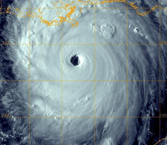
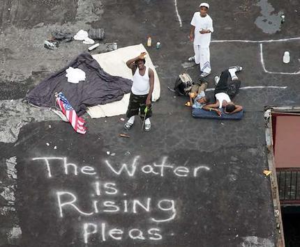
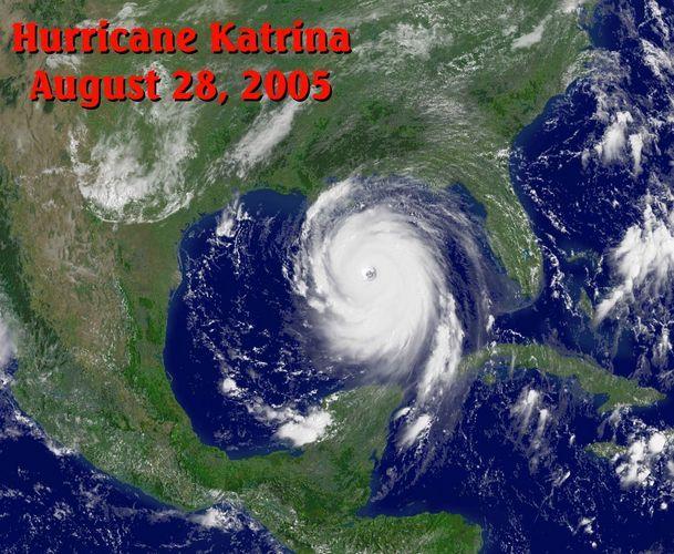
2 Hurricane Katrina August 29 th, 2005 Costliest Disaster/One of the 5 deadliest Hurricanes in US History. Total Cost: Approx. $100 Billion in damages Over 15 million affected by Katrina whether it was due to the economy, evacuations, gas shortages, or even drinking water. 1,836 people died Wind Gusts 175 MPH/ 14 inches of rain 24 hours

3
4 Hurricane History New Orleans has always been a target for Storm Surges Over 10% of hurricanes that make landfall in American Atlantic Coast between 1851 and 2004 made landfall in Louisiana. 18/92 with Saffir Simpson Rating of Cat 3 or above struck stated Hurricane of 1947, Hurricane Betsy (1965), Hurricane Camille (1969) Hurricane Georges (1998) and Hurricane Ivan (2004) demonstrated the potential dangers in New Orleans Hurricane Response Tactics. Especially the evacuation plans
5

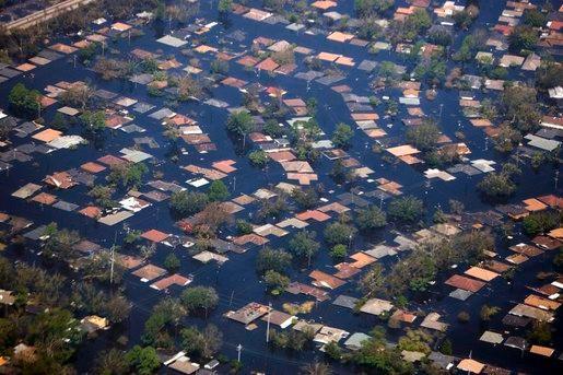
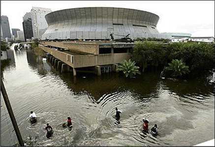
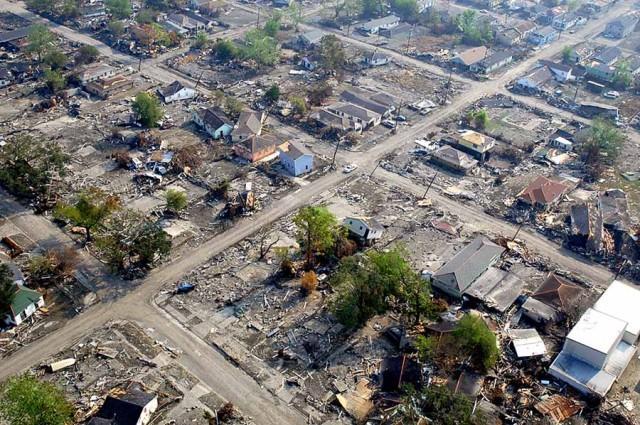
6 We were expecting a hurricane but we got a flood Mayor Mitch Landrieu New Orleans s experiences with hurricanes means the city is prepared to deal with a hurricane Levee System The Breaking of the Levee/Overload of the Pumping System The city would have still undertook a significant amount of damage however the levee flooding is where the majority of damage came from.


7 BEFORE AFTER

8 Federal Emergency Management Agency Heavily criticized for their response to the Hurricane House of Reps organized the Select Bipartisan Committee to Investigate the Preparation for and Response to Hurricane Katrina: "The Secretary Department of Homeland Security should have designated the Principal Federal Official on Saturday, two days prior to landfall, from the roster of PFOs who had successfully completed the required training, unlike then FEMA Director Michael Brown. Considerable confusion was caused by the Secretary s PFO decisions." "Department of Homeland Security and FEMA lacked adequate trained and experienced staff for the Katrina response." "The readiness of FEMA s national emergency response teams was inadequate and reduced the effectiveness of the federal response." "Long-standing weaknesses and the magnitude of the disaster overwhelmed FEMA s ability to provide emergency shelter and temporary housing." FEMA logistics and contracting systems did not support a targeted, massive, and sustained provision of commodities." "Before Katrina, FEMA suffered from a lack of sufficiently trained procurement professionals. Michael D Brown, then FEMA director, resigned on Sept. 12, 2005 after taking extreme criticism.
9 New Orleans Evacuation Plan for Katrina Headlines/Quotes in Newspapers pre-katrina New Orleans City Officials Plan to Use Buses to Evacuate Some Residents; Lacks Capacity for Full Evacuation July 2005: Times-Picayune Hurricane Ivan Demonstrates Need to Improve New Orleans Evacuation Plan September 2004: Washington Post Ivan was a real wake-up call. We have to take Ivan s near-miss to get the federal government to fast-track some of these restoration projects, says Ivor van Heerden, the deputy director of the LSU Hurricane Center. Oct Philidelphia Inquirer For example, FEMA writes that the emergency management community has long feared the occurrence of a catastrophic disaster that would cause unprecedented levels of damage, casualties, dislocation, and disruption that would have nationwide consequences and jeopardize national security. Dept. of Homeland Sec They saw it coming!

10 Evacuation Evacuation statistics are not too bad. Better than Hurricane Ivan because of Mandatory Evacuation: About 80% of city evacuated 26,000 sheltered in New Orleans Superdome Lack of public transportation however kept many of the poor stranded.
11 Hurricane Gustav s Relevance Fall 2008 Anticipated to be the storm of the century Mayor Ray Nagin:"This is the real deal, not a test, "For everyone thinking they can ride this storm out, I have news for you: that will be one of the biggest mistakes you can make in your life." Contraflow Lane Reversal on all major highways, and 700 buses to help move evacuees. 1.9 Million people evacuated South Louisiana City much more wary of Hurricanes


12 Post-Katrina: What now? Rebuilding: Voluntary Programs, Religious Organization Help, Celebrity Coverage BUT, how to make sure it won t happen again?


13 US Army Corp of Engineers Given the task of recreating the city s defense against hurricanes First task: Get rid of the water: removed 250 gallons of water from the city in 53 days Next: Protect the city
14 100-Year Level of Protection Plan Protects from storm surge flooding caused by hurricanes with a 1 percent chance of occurring in any year, often referred to as a 100-year storm. 4/50 major levee resulted from foundation-induced failures. Remainder: combination of overtopping and scour. To address these issues: some levees and floodwalls have been (or are in the process of being) raised and in some areas widened.
 Turf Reinforced Mats Concrete")
15 100-Year Level of Protection Plan How to protect from scour: Extra Grass Large Stones (rip-rap) Turf Reinforced Mats Concrete Slabs
16 Progress Today June 1 st 2011 is the projected completion date $10 billion in construction contracts (288) has been obligated (60% to New Orleans Businesses) 98% of projects completed as of now All surge barriers, interior floodwalls, exterior floodwalls, T-walls and levees will be ready by June 1 st. 1.8 miles of wall/month is the rate now; expected to increase to 2.
17 Works Cited 100-Year Level of Protection. US Army Corp of Engineers: Team New Orleans. US Army, n.d. Web. 13 Nov < Guarino, Mark. Would New Orleans levees hold for a second Katrina? The Christian Science Monitor. The First Church of Christ, 29 Aug Web. 13 Nov < Hurricane Katrina: Evacuation. History Commons. Center for Grassroots Oversight, n.d. Web. 12 Nov < timeline=hurricane_katrina_tmln&katrina_emergency_preparedness/response_plans=katrina_evacuationplanning>. Kurpis, Brian. Hurricane Katrina Relief FAQs. HurricaneKatrinaRelief.com. N.p., Web. 14 Nov < McCarragher, Barbara. Hurricanes: History. Mission: Project New Orleans. Massachusetts Institute of Technology, n.d. Web. 13 Nov < New Orleans Levee System. New Orleans Levees.com. Official Florida Visitor Guide.com Network & Internet Publishing Group, n.d. Web. 12 Nov < Schleifstein, Mark. Corps says 100-year level of protection due June 1. Times-Picayune 10 Nov. 2010: n. pag. Web. 12 Nov <
Hurricane Tracking Lab
 Hurricane Tracking Lab Background: Hurricanes are one of nature s most powerful disasters. To equal the power of a hurricane, one would have to set off about a thousand nuclear devices per second for as
Greater New Orleans Hurricane and Storm Damage Risk Reduction System 101
 Greater New Orleans Hurricane and Storm Damage Risk Reduction System 101 René Poché New Orleans District U.S. Army Corps of Engineers US Army Corps of Engineers BUILDING STRONG 1878 Gentilly Ridge Metairie
US Army Corps of Engineers BUILDING STRONG
 Greater New Orleans Hurricane and Storm Damage Risk Reduction System Robert Rowlette Senior Senior Program Manager Task Force Hope U.S. Army Corps of Engineers April 19, 2012 US Army Corps of Engineers
2006 & 2007 Pre-Hurricane Scenario Analyses
 2006 & 2007 Pre-Hurricane Scenario Analyses Executive Summary May 2007 Page 1 OF X FOR OFFICIAL USE ONLY 4 Public Availability to be Determined Under 5 U.S.C. 552 NOTE: Limited Distribution. Release of
Phases of Disaster Response. John Yeaw, Gavin Vanstone, Haochen Wu, Jordan Tyler
 Phases of Disaster Response John Yeaw, Gavin Vanstone, Haochen Wu, Jordan Tyler BP Oil Spill One of the worst man made disasters in human history The BP oil spill occurred in April of 2010 when the Deepwater
Improvements to Southeast Louisiana s floodwalls and pump stations since Katrina: the Hurricane and Storm Damage Risk Reduction System (HSDRRS)
") Improvements to Southeast Louisiana s floodwalls and pump stations since Katrina: the Hurricane and Storm Damage Risk Reduction System (HSDRRS) Pat Fitzpatrick Mississippi State University Review of levee
Improvements to Southeast Louisiana s floodwalls and pump stations since Katrina: the Hurricane and Storm Damage Risk Reduction System (HSDRRS) Pat Fitzpatrick Mississippi State University Review of levee
Hurricane KATRINA Lessons Learned for Managing Risk
 Hurricane KATRINA Lessons Learned for Managing Risk Steven L. Stockton, P.E. Deputy Director of Civil Works U.S. Army Corps of Engineers What Happened? Storm Path from August 23 to 31, 2005 Mon. August
Hurricanes and Storm Surge : Before coming to lab, visit the following web site:
 Geol 108 Lab #7 Week of October 15-19, 2012 Coastal Studies Hurricanes and Storm Surge : Before coming to lab, visit the following web site: http://www.usatoday.com/graphics/weather/gra/gsurge/flash.htm
A HURRICANE IS COMING. Presented by Atiba Upchurch Broward Emergency Management Division
 A HURRICANE IS COMING Presented by Atiba Upchurch Broward Emergency Management Division Mission Statement To safeguard the lives and property of the people of Broward County from major hazards and emergencies
PART 4 HURRICANE KATRINA STRIKES NEW ORLEANS AUGUST 2005
 PART 4 HURRICANE KATRINA STRIKES NEW ORLEANS AUGUST 2005 Hurricane Katrina Hurricane Katrina swept across southern Florida and lost momentum, then gained speed and water, showing the second lowest barometric
Construction complete on all HSDRRS projects across storm evacuation routes
 Task Force Hope Status Report August 29, 2013 Construction complete on all HSDRRS projects across storm evacuation routes Eastern Tie-In Swing Gates positioned across Hwy. 23 By Susan Spaht If a tropical
NWS HURRICANES June 3, 2015
 NWS HURRICANES June 3, 2015 Hurricane Season June 1 November 30 2 What s the concern? All tropical systems passing within 125nm of central Maryland since 1950 Mid-Atlantic Hurricanes Greatest Risk: August
Department of Industrial and Manufacturing Systems Engineering. The Online Hurricane Decision Simulator
 Department of The Online Hurricane Decision Simulator Cameron MacKenzie Assistant Professor Iowa State University Eva Regnier Associate Professor Naval Postgraduate 1 U.S. Marine Forces Reserve (MFR) Lt.
CHAPTER FIVE: THE LOWER MISSISSIPPI REGION AND PLAQUEMINES PARISH
 CHAPTER FIVE: THE LOWER MISSISSIPPI REGION AND PLAQUEMINES PARISH 5.1 Overview Plaquemines Parish is the area where the last portion of the Mississippi River flows out into the Gulf of Mexico (see Figures
City of Punta Gorda Community Emergency Management Plan 2013
 City of Punta Gorda Community Emergency Management Plan 2013 Hurricane Andrew- August 24, 1992 Category 5 hurricane. The second-most-destructive hurricane in U.S. history. The first named storm of the
Geography Year 9 Home Learning Booklet. Hurricanes and Hurricane Katrina
 Geography Year 9 Home Learning Booklet Hurricanes and Hurricane Katrina Name Tutor Group Teacher Given out Tuesday 31st October Hand in Monday 6th November Parent/Carer Comment Staff Comment Target Your
SITUATION REPORT #7 September 8 th, 2017
 MCO AIRPORT EMERGENCY OPERATIONS CENTER SITUATION REPORT #7 September 8 th, 2017 STATE OF FLORIDA REGION V FEMA REGION IV GENERAL INFORMATION Local State of Emergency Declaration Number: 17-235 Dated:
Chapter 16, Part Hurricane Paths. 2. Hurricane Paths. Hurricane Paths and Damage
 Chapter 16, Part 2 Hurricane Paths and Damage 1. Hurricane Paths Start over tropical water except South Atlantic and eastern South Atlantic, where water is too cold. Initially steered by easterly winds
Major Hurricane Matthew Briefing Situation Overview
 Major Hurricane Matthew Briefing Situation Overview THIS IS NOW A WORST CASE STORM SURGE SCENARIO Catastrophic Damage is Anticipated for Coastal Areas. Major Hurricane Matthew is still expected to move
Typhoon Maemi and Hurricane Katrina: Impacts and Aftermath. Typhoon Maemi: September 13, Typhoon Maemi Track and Characteristics
 Typhoon Maemi and Hurricane Katrina: Impacts and Aftermath Pierre Julien Un Ji Department of Civil Engineering Colorado State University Fort Collins, Colorado USA September, 2005 Typhoon Maemi: September
The Saffir-Simpson Hurricane Wind Scale
 The Saffir-Simpson Hurricane Wind Scale The Saffir-Simpson Hurricane Wind Scale is a one to five categorization based on the hurricane's intensity at the indicated time. The scale provides examples of
Top 10 Actions a CIO Can Take to Prepare for a Hurricane
 May 2013 Walter E. Washington Convention Center Washington, DC Top 10 Actions a CIO Can Take to Prepare for a Hurricane Lessons learned from Hurricane Sandy Bill Venteicher Marketing Manager Dell Email
2008 Hurricane Caravan. Daniel Noah Meteorologist National Weather Service x1 May 22, 2008
 2008 Hurricane Caravan Daniel Noah Meteorologist National Weather Service daniel.noah@noaa.gov, 813-645-2323 x1 May 22, 2008 National Weather Service We never close! Open 24 hours a day 365 days per year
Tropical Revolving Storms: Cuba 2008 By The British Geographer
 Place Context Tropical Revolving Storms: Cuba 2008 By The British Geographer The Republic of Cuba is located in the northern tropics with in island chain of the Caribbean. It is made up of one large Island,
Hurricane Preparation and Recovery. October 11, 2011 Jon Nance, Chief Engineer, NCDOT
 Hurricane Preparation and Recovery October 11, 2011 Jon Nance, Chief Engineer, NCDOT North Carolina & Severe Weather Our state often bears the brunt of storms, which include: Ice storms Snow storms Heavy
Miami-Dade County Overview
 Miami-Dade County Overview 2,000 square miles World s busiest cruise port 2.6 million residents Second busiest US airport for international travelers Gateway to the Caribbean and Latin America Natural
Hurricane Tracks. Isaac versus previous storms Impacts and solutions. ( Continue by clicking on the slide bar to the right)
") Hurricane Tracks Isaac versus previous storms Impacts and solutions ( Continue by clicking on the slide bar to the right) 1 Hurricane Tracks 2 Sample Hurricanes The sample hurricanes selected were chosen
Hurricane Tracks Isaac versus previous storms Impacts and solutions ( Continue by clicking on the slide bar to the right) 1 Hurricane Tracks 2 Sample Hurricanes The sample hurricanes selected were chosen
Navigating the Hurricane Highway Understanding Hurricanes With Google Earth
 Navigating the Hurricane Highway Understanding Hurricanes With Google Earth 2008 Amato Evan, Kelda Hutson, Steve Kluge, Lindsey Kropuenke, Margaret Mooney, and Joe Turk Images and data courtesy hurricanetracking.com,
KCC White Paper: The 100 Year Hurricane. Could it happen this year? Are insurers prepared? KAREN CLARK & COMPANY. June 2014
 KAREN CLARK & COMPANY KCC White Paper: The 100 Year Hurricane Could it happen this year? Are insurers prepared? June 2014 Copyright 2014 Karen Clark & Company The 100 Year Hurricane Page 1 2 COPLEY PLACE
2015 Plymouth Rock Assurance New Jersey Hurricane Preparedness Study
 2015 Plymouth Rock Assurance New Jersey Hurricane Preparedness Study About This Study Tropical storms and hurricanes directly and indirectly impact New Jersey and its 130 miles of Atlantic coastline. Although
Welcome Jeff Orrock Warning Coordination Meteorologist National Weather Service Raleigh
 Welcome Jeff Orrock Warning Coordination Meteorologist National Weather Service Raleigh Jeff.orrock@noaa.gov Sources: Operational Significant Event Imagery and the Environmental Applications Team (EAT)
A Utility s Response and Recovery. Marc Butts Southern Company 03/19/2014
 A Utility s Response and Recovery Marc Butts Southern Company 03/19/2014 Service territory across four states: 120,000 square miles Serves approximately 4 million customers Other Subsidiaries: Southern
Hurricane Katrina. Learning Objective: -Analyse the causes, effects and responses of a tropical storm
 Hurricane Katrina Learning Objective: -Analyse the causes, effects and responses of a tropical storm Learning Outcomes: -Classify the impacts of Hurricane Katrina -Apply understanding to an exam question
Report on the Damage Survey Caused by Hurricane Katrina (Tentative Report)
") Report on the Damage Survey Caused by Hurricane Katrina (Tentative Report) November 1, 2005 Coastal Disaster Prevention Technology Survey Team 1. Introduction Hurricane Katrina struck the United States
Report on the Damage Survey Caused by Hurricane Katrina (Tentative Report) November 1, 2005 Coastal Disaster Prevention Technology Survey Team 1. Introduction Hurricane Katrina struck the United States
4.2: Disaster Mitigation Strategies
 WMO/CAS/WWW SEVENTH INTERNATIONAL WORKSHOP ON TROPICAL CYCLONES 4.2: Disaster Mitigation Strategies Rapporteurs: Bill Read Regional Specialized Meteorological Center (RSMC) WMO Region IV 11691 SW 17 th
SLOSH New Orleans Basin 2012 Update
 SLOSH New Orleans Basin 2012 Update Michael Koziara Science and Operations Officer National Weather Service Slidell, LA The Basics What is storm surge? What is SLOSH? Details Assumptions Inundation = Storm
Hurricane Katrina kills hundreds
 www.breaking News English.com Ready-to-use ESL / EFL Lessons Hurricane Katrina kills hundreds URL: http://www.breakingnewsenglish.com/0508/050831-katrina-e.html Today s contents The Article 2 Warm-ups
2017 Hurricane Season and Beyond
 2017 Hurricane Season and Beyond Ken Graham National Hurricane Center Building a Weather-Ready Nation Much of U.S. Coast Saw Tropical Wind Watches or Warnings 2017 Hurricane Season Facts and Figures 7th
Hurricane Sandy. Background Information and (first) Disaster Assessment Report. ( as of) Nov, 2 nd 2012
 Disaster Assessment Report. ( as of) Nov, 2 nd 2012") Background Information and (first) Disaster Assessment Report ( as of) Nov, 2 nd 2012 Wasserbau und Küsteningenieurwesen BSc Bau- und Umweltingenieurwesen - WS2012/13 Prof. Dr. T. Schlurmann Franzius-Institute
Background Information and (first) Disaster Assessment Report ( as of) Nov, 2 nd 2012 Wasserbau und Küsteningenieurwesen BSc Bau- und Umweltingenieurwesen - WS2012/13 Prof. Dr. T. Schlurmann Franzius-Institute
Rebuilding Flood-Conscious Society
 A zone where strong flood flow or river bank erosion by levee breach are anticipated, which likely to occur collapsing/washing away of house. Set up the joint councils by relative stakeholders(river managers,
Research Report. Hurricane Sandy. 20F Science Extreme Weather. October, By: November 5th, 2013 Period 6 20F Science Submitted to: Miss Brunel
 20F Science Extreme Weather Research Report Hurricane Sandy October, 2012 By: November 5th, 2013 Period 6 20F Science Submitted to: Miss Brunel Table of Contents 1.0 Introduction... 2 2.0 Summary of [Hurricanes]...
STORM HISTORY FOR COLLIER COUNTY
 STORM HISTORY FOR COLLIER COUNTY In 1960, when hurricane 'Donna' struck, there were approximately 15,500 people living full time in Collier County. Today there are more than 330,000 residents, most of
Ch. 11: Hurricanes. Be able to. Define what hurricane is. Identify the life and death of a hurricane. Identify the ways we track hurricanes.
 Ch. 11: Hurricanes Be able to Define what hurricane is. Identify the life and death of a hurricane. Identify the ways we track hurricanes. What are Hurricanes? Smaller than mid-latitude cyclones. Don t
A Hurricane Outlook for the 21st Century.
 A Hurricane Outlook for the 21st Century. Hugh Willoughby Florida International University Cat Winds Effects One 74-95 mph No real damage to building structures. Two Three Four Five 96-110 mph 111-130
Hurricane Basics and Preparedness. Jim Weyman Director, Central Pacific Hurricane Center Phone Office:
 Hurricane Basics and Preparedness Jim Weyman Director, Central Pacific Hurricane Center Phone Office: 973-5270 james.weyman@noaa.gov United States Hurricane/Typhoon Centers National Hurricane Center, Miami
Weather Compass Webquest: Hurricane Edition
 Property of Weather Compass!2011 1 Weather Compass Webquest: Hurricane Edition www.weathercompass.webs.com Name: Class: Date: Period: Welcome to the Weather Compass Webquest: Hurricane Edition. The pictures
MODELLING CATASTROPHIC COASTAL FLOOD RISKS AROUND THE WORLD
 MODELLING CATASTROPHIC COASTAL FLOOD RISKS AROUND THE WORLD Nicola Howe Christopher Thomas Copyright 2016 Risk Management Solutions, Inc. All Rights Reserved. June 27, 2016 1 OUTLINE MOTIVATION What we
Hurricanes and coastal storms pose a risk because powerful winds and storm surges can:
 HURRICANES A hurricane is a violent area of low pressure forming in the tropical Atlantic Ocean from June to November. August and September are peak months. (Similar Western Pacific Ocean storms are called
HAZUS-MH: A Predictable Hurricane Risk Assessment Tool for the City of Houston and Harris County
 HAZUS-MH: A Predictable Hurricane Risk Assessment Tool for the City of Houston and Harris County Presented by Melvin G. Spinks, P.E., President Annie Ding, PhD, GISP October 29, 2008 Rice University Contents
GC Briefing. Weather Sentinel Tropical Storm Michael. Status at 8 AM EDT (12 UTC) Today (NHC) Discussion. October 11, 2018
 Today (NHC) Discussion. October 11, 2018") GC Briefing Weather Sentinel Tropical Storm Michael October 11, 2018 After making landfall as a high-end category-4 hurricane on the Florida Panhandle, Michael weakened to tropical storm status early this
GC Briefing Weather Sentinel Tropical Storm Michael October 11, 2018 After making landfall as a high-end category-4 hurricane on the Florida Panhandle, Michael weakened to tropical storm status early this
Canes on Canes: Keeping South Florida Prepared During the Calm Before the Storm. Matt Onderlinde and Pete Finocchio
 Canes on Canes: Keeping South Florida Prepared During the Calm Before the Storm Matt Onderlinde and Pete Finocchio Outline The Science of Hurricanes Why and When South Floridians Must Be Weather-Ready
Urgent Computing for Hurricane Forecasts
 Urgent Computing for Hurricane Forecasts Gabrielle Allen Center for Computation & Technology Dept Computer Science Louisiana State University gallen@cct.lsu.edu Representing the SURA Coastal Ocean Observing
Weather Middle School Teacher Instructions and Activity
 Weather Middle School Teacher Instructions and Activity Based on the guidelines of the Saffir-Simpson Scale for hurricane severity and the Fujita Scale for tornado damage, students will write a brief synopsis
LECTURE #18: Hurricane Damage, Monitoring & Case Study
 GEOL 0820 Ramsey Natural Disasters Spring, 2018 LECTURE #18: Hurricane Damage, Monitoring & Case Study Date: 27 March 2018 I. Exam II grades now posted online o high: 98, low: 46, average: 80 (~3 points
National Hurricane Program. FEMA Region IV
 National Hurricane Program FEMA Region IV Percent NHP A quick background Hurricane Program major buckets (Toolboxes) Hurricane Evacuation Study HURREVAC Post Storm Assessments Training Hurricane Liaison
Hurricane Protection and Environmental Restoration
 November 16, 2010 Hurricane Protection and Environmental Restoration Presented by: Colonel (Ret.) Leonard Waterworth AGENDA How do we protect People/Environment/Economy 1900 Year Storm Hurricane Carla
Post-Hurricane Recovery: How Long Does it Take?
 Post-Hurricane Recovery: How Long Does it Take? Implications for disaster recovery after hurricanes Harvey and Irma In the following report, BuildFax analyzed the geographic areas impacted by three of
Tropical Cyclone Hazards. Presentation
 Tropical Cyclone Hazards Presentation Kerry N Mallory AE5JY September 7, 2011 Tropical Cyclone Hazards The Four Primary Weapons of a Tropical Cyclone are: 1. Wind 2. Storm Surge 3. Rain/Freshwater Flooding
Hurricane Recipe. Hurricanes
 Hurricanes A hurricane is a powerful, rotating storm that forms over warm oceans near the Equator. Hurricanes have strong, rotating winds (at least 74 miles per hour), a huge amount of rain, low air pressure,
Hurricane Irma. City of Cocoa Beach September 8 12, 2017
 Hurricane Irma City of Cocoa Beach September 8 12, 2017 Monitoring prior to landfall Expected effects What happened What went well What didn t go well Changes and improvements After Action Outline Storm
Hurricane Katrina and Oil Spills: Impact on Coastal and Ocean Environments
 Archived version from NCDOCKS Institutional Repository http://libres.uncg.edu/ir/asu/ Pine, J. C. (June 2006). Hurricane Katrina and oil spills: Impact on coastal and ocean environments. Oceanography,
WEDNESDAY 30 TH AUGUST, :57 p.m. Tropical Storm Irma forms in the Atlantic. Don t let your guard down, always #Be Ready.
 Chapter 1 - The Set Up In the days leading up to Irma a series of composed and sobering text messages, presented in truncated form below, from Department of Disaster Management warned us of the pending
3Chapter Three: Rescue and Response
 17 16 Report Science Title and the Storms: the USGS Response to the Hurricanes of 2005 3Chapter Three: Rescue and Response This chapter documents the U.S. Geological Survey s (USGS) humanitarian rescue
Table 1: Saffir-Simpson Hurricane Wind Scale (NHC)
") SCIPP HURRICANE INFORMATION DOCUMENT INTRODUCTION TO HURRICANES : Since 1980, hurricanes and tropical storms have been responsible for $367.3 billion in damage out of all billion dollar U.S. climate and
SCIPP HURRICANE INFORMATION DOCUMENT INTRODUCTION TO HURRICANES : Since 1980, hurricanes and tropical storms have been responsible for $367.3 billion in damage out of all billion dollar U.S. climate and
Tropical Activity. Atlantic Hurricane Florence (CAT 4)
") Tropical Activity Atlantic Hurricane Florence (CAT 4) Located 530 miles southeast of Cape Fear, NC Moving WNW at 17 mph; maximum sustained winds 130 mph Expected to slow down considerably by late Thursday
Tropical Activity Atlantic Hurricane Florence (CAT 4) Located 530 miles southeast of Cape Fear, NC Moving WNW at 17 mph; maximum sustained winds 130 mph Expected to slow down considerably by late Thursday
Friday, September 7, :30 a.m. EDT
 Friday, September 7, 2018 8:30 a.m. EDT Tropical Depression Gordon - Final Situation (Advisory #20 as of 5:00 a.m. EDT) Located 30 miles S of Little Rock, AR Moving N at 5 mph; this motion expected to
Racing against time, an unprecedented year: the US Army Corps of Engineers (USACE) response to the hurricanes of 2004
 response to the hurricanes of 2004") Environmental Problems in Coastal Regions VI 205 Racing against time, an unprecedented year: the US Army Corps of Engineers (USACE) response to the hurricanes of 2004 R. I. McMillen 1, D. R. Haubner 2,
Environmental Problems in Coastal Regions VI 205 Racing against time, an unprecedented year: the US Army Corps of Engineers (USACE) response to the hurricanes of 2004 R. I. McMillen 1, D. R. Haubner 2,
Tropical Activity. Atlantic Hurricane Florence (CAT 4)
") Tropical Activity Atlantic Hurricane Florence (CAT 4) As of 8 a.m. ET Tuesday, Florence's center had maximum sustained winds of 130 mph and was about 950 miles east-southeast of Cape Fear, North Carolina.
Tropical Activity Atlantic Hurricane Florence (CAT 4) As of 8 a.m. ET Tuesday, Florence's center had maximum sustained winds of 130 mph and was about 950 miles east-southeast of Cape Fear, North Carolina.
Hurricane Preparedness and Awareness!
 Hurricane Preparedness and Awareness! Check these out Time to begin executing the evacuation plan What kind of damage are we talking about here? What Exactly Is a Hurricane? A hurricane can best be described
Hurricanes. Cause: a low pressure storm system over warm ocean water. Effect: potential massive widespread destruction and flooding.
 Hurricanes Hurricanes Cause: a low pressure storm system over warm ocean water. Effect: potential massive widespread destruction and flooding. Hurricanes also known as: cyclone (Indian Ocean) or typhoon
Hurricanes. Environmental Geology Mr. Paul Lowrey. Stacey Singleton, Cassandra Combs, Dwight Stephenson, Matt Smithyman
 Environmental Geology Mr. Paul Lowrey Stacey Singleton, Cassandra Combs, Dwight Stephenson, Matt Smithyman Hurricanes EMPACTS Project, Spring 2017 Northwest Arkansas Community College, Bentonville, AR
Homework Assignment IV. Weather Exercises
 Page 1 of 5 EENS 3050/6050 Tulane University Natural Disasters Prof. Stephen A. Nelson Homework Assignment IV. Weather Exercises This document last updated on 16-Nov-2016 1. Go to the following link to
Modeling Nearshore Waves for Hurricane Katrina
 Modeling Nearshore Waves for Hurricane Katrina Jane McKee Smith US Army Engineer Research & Development Center Coastal and Hydraulics Laboratory Outline Introduction Modeling Approach Hurricane Katrina
HURRICANE MARIA PUERTO RICO ASSESSMENT FOUR & SIX MONTHS POST LANDFALL. January & March 2018
 HURRICANE MARIA PUERTO RICO ASSESSMENT FOUR & SIX MONTHS POST LANDFALL January & March 2018 CONCLUSIONS OF FIELD RECON JANUARY AND MARCH 2018 JLT Re conducted an island wide damage survey four month after
The Hurricane Decision Simulator A Tool for Marine Forces in New Orleans to Practice Operations Management in Advance of a Hurricane
 Department of The Hurricane Decision Simulator A Tool for Marine Forces in New Orleans to Practice Operations Management in Advance of a Hurricane Eva Regnier, Associate Professor, Graduate School of Business
Tropical Storm Isaac Situation Report #2 Monday, August 27, :30 PM (EDT)
") Tropical Storm Isaac Situation Report #2 Monday, August 27, 2012 2:30 PM (EDT) CURRENT SITUATION: RAINFALL BEGINS TO IMPACT THE FLORIDA GULF COAST... FLORIDA, MISSISSIPPI, LOUISIANA, AND ALABAMA HAVE DECLARED
Tropical Storm Isaac Situation Report #2 Monday, August 27, 2012 2:30 PM (EDT) CURRENT SITUATION: RAINFALL BEGINS TO IMPACT THE FLORIDA GULF COAST... FLORIDA, MISSISSIPPI, LOUISIANA, AND ALABAMA HAVE DECLARED
CATEX Hurricane Zachary
 CATEX Hurricane Zachary EXERCISE, EXERCISE,EXERCISE East Coast CATEX Power Restoration Functional Exercise 2013 This document was prepared under a grant from FEMA's Grants Programs Directorate, U.S. Department
United States Multi-Hazard Early Warning System
 United States Multi-Hazard Early Warning System Saving Lives Through Partnership Lynn Maximuk National Weather Service Director, Central Region Kansas City, Missouri America s s Weather Enterprise: Protecting
OSCILLATIONS OF SEMI-ENCLOSED WATER BODY INDUCED BY HURRICANES. Yuan-Hung Paul Tan 1 and Jiin-Jen Lee 1
 OSCILLATIONS OF SEMI-ENCLOSED WATER BODY INDUCED BY HURRICANES Yuan-Hung Paul Tan 1 and Jiin-Jen Lee 1 The primary focus of this research is to study the oscillations of semi-enclosed water body induced
Exploring the costs of sea level rise: should we focus on means or extremes?
 Exploring the costs of sea level rise: should we focus on means or extremes? Robert Muir-Wood Chief Research Officer, RMS AAAS Chicago Feb 16 th 2009 Change Points in Cat 3-5 Hurricane Numbers (the drivers
HURRICANE CHARLEY CHARACTERISTICS and STORM TIDE EVALUATION
 HURRICANE CHARLEY CHARACTERISTICS and STORM TIDE EVALUATION By Robert Wang, Michael Manausa And Jenny Cheng Sponsored by Florida Department of Environmental Protection, Bureau of Beaches and Coastal Systems
Hurricane Katrina Tracking Lab
 Hurricane Katrina Tracking Lab Introduction: The 2005 hurricane season was the most active season on record resulting in 28 named storms. Hurricane Katrina was the eleventh named storm and would end up
Smart Flood Risk Management Solutions
 Smart Flood Risk Management Solutions - RHDHV s Experience in the Gulf of Mexico Mathijs van Ledden, Marten Hillen and Ries Kluskens Challenge Extreme weather around the world (hurricanes, cyclones, extratropical
Skupos Data Helps Convenience Stores Predict Inventory Needs Before Hurricanes
 Case Study: Hurricane Florence Winter 2018 SKUPOS Inc. 300 Kansas St. Suite 103 San Francisco, CA 94103 www.skupos.com Skupos Data Helps Convenience Stores Predict Inventory Needs Before Hurricanes A Look
Managing an Extreme Weather Event of Prolonged Duration May 22, 2013
 Managing an Extreme Weather Event of Prolonged Duration May 22, 2013 MISSOURI RIVER FLOOD OF 2011 M I C H A E L J. K E N N E R L Y P. E. D I R E C T O R O F T H E O F F I C E O F D E S I G N I O W A D
National Situation Report As of 3:00 a.m. EDT, Sunday, October 8, 2017 Table of Contents Current Operations Monitoring Recovery
 Overview National Situation Report As of 3:00 a.m. EDT, Sunday, October 8, 2017 Table of Contents Current Operations Monitoring Recovery FEMA Headquarters Status FEMA Region Status NRCC Level I (24/7)
2015 Hurricane Season BY: STORM TEAM 8 METEOROLOGIST JULIE PHILLIPS
 2015 Hurricane Season BY: STORM TEAM 8 METEOROLOGIST JULIE PHILLIPS FORECAST COLORADO STATE UNIVERSITY FORECAST IS CALLING FOR ONE OF THE LEAST ACTIVE SEASONS SINCE THE MID 20 TH CENTURY! THE OFFICIAL
2015 Hurricane Season Outlook and Preparedness. Amy Godsey State Meteorologist State Emergency Response Team Florida Division of Emergency Management
 2015 Hurricane Season Outlook and Preparedness Amy Godsey State Meteorologist State Emergency Response Team Florida Division of Emergency Management 2015 Hurricane Season Last Hurricane Landfall: Kate
HURRICANES. Source:
 HURRICANES Source: http://www.dc.peachnet.edu/~pgore/students/w97/matheson/hpage.htm What is a hurricane? Violent cyclonic storm that develops in the tropical region Wind speeds are > 74 mph Source: http://www.google.com/imgres?hl=en&sa=x&biw=1920&bih=955&tbm=
2014 Emergency Preparedness Conference. Tuesday, June 3, 2014 The Wildwoods Convention Center 4501 Boardwalk Wildwood, New Jersey 08260
 2014 Emergency Preparedness Conference Tuesday, June 3, 2014 The Wildwoods Convention Center 4501 Boardwalk Wildwood, New Jersey 08260 A Look back at Winter 2013-2014 A Look ahead to the 2014 Hurricane
Monday, May 28, :30 a.m. EDT
 Monday, May 28, 2018 8:30 a.m. EDT Significant Activity May 27-28 Significant Events: Subtropical Storm Alberto; Ellicott City, MD flooding Tropical Activity: Atlantic Subtropical Storm Alberto Significant
Hurricane Florence: Rain this heavy comes along once every 1,000 years
 Hurricane Florence: Rain this heavy comes along once every 1,000 years By Associated Press, adapted by Newsela staff on 09.17.18 Word Count 786 Level 810L Image 1. This satellite image provided by the
NC Emergency Management A View from the Counties
 NC Emergency Management A View from the Counties Amy Bason, NCACC Rocky Hyder, Henderson County Jeff Batten, Durham County Norman Bryson, Onslow County PARTNERSHIP Emergency Management efforts require
Hurricane Andrew was truly
 HOW PALM HARBOR HOMES SURVIVED HURRICANE ANDREW. Hurricane Andrew was truly a monstrous storm. Blasting South Florida with gusts of more than 175 miles an hour and spawning tornadoes of even greater ferocity,
Hurricane Awareness 2017
 Hurricane Awareness 2017 Hurricane Isabel from the International Space Station NASCC Emergency Management Department When will a Hurricane hit Corpus Christi? Port Lavaca Rockport Corpus Christi Kingsville
Agricultural Outlook Forum Presented: February 17, 2006 THE SCIENCE BEHIND THE ATLANTIC HURRICANES AND SEASONAL PREDICTIONS
 Agricultural Outlook Forum Presented: February 17, 2006 THE SCIENCE BEHIND THE ATLANTIC HURRICANES AND SEASONAL PREDICTIONS Gerald Bell Meteorologist, National Centers for Environmental Prediction NOAA,
30 If Vmax > 150, HSI intensity pts = 25
 Hurricane Severity Index: A New Way of Estimating a Tropical Cyclone s Destructive Potential 1. Introduction Christopher G. Hebert*, Robert A. Weinzapfel*, Mark A. Chambers* Impactweather, Inc., Houston,
Where Do Hurricanes Occur?
 Where Do Hurricanes Occur? How Often Do Hurricanes Hit the U.S.? Hurricane Return Periods Hurricane return periods are the frequency at which a certain intensity of hurricane can be expected within a
Hurricane Season 2018
 Hurricane Season 2018 Mission Protect LIFE and Property (Save Lives and Livelihoods) NOAA/ National Weather Service We are NOT a 9-to-5 agency. We operate 24/7/365 serving communities. We are available
Using Functions in Models and Decision Making: Step and Piecewise Functions V.C Student Activity Sheet 8: Introducing Step and Piecewise Functions
 Using in Models and Decision Making: Step and Piecewise Texas experiences a wide variety of weather, including hurricanes. Coastal residents often feel the direct effects of hurricanes when they make landfall