HURRICANE MARIA PUERTO RICO ASSESSMENT FOUR & SIX MONTHS POST LANDFALL. January & March 2018
|
|
|
- Morgan Stanley
- 5 years ago
- Views:
Transcription

1 HURRICANE MARIA PUERTO RICO ASSESSMENT FOUR & SIX MONTHS POST LANDFALL January & March 2018
2 CONCLUSIONS OF FIELD RECON JANUARY AND MARCH 2018 JLT Re conducted an island wide damage survey four month after landfall in January 2018, with a follow up assessment in greater San Juan six months after landfall. Common themes included: 1. Whether residential or commercial, category 4-5 winds can be sustained without major structural damage, and are likely fully operational once electric power is restored. These structures are built exceeding building code requirements and have appropriate emergency contingency plans in place. 2. Mixed construction saw poor performance in wind speeds as low as category 2. Any roofs that were not concrete performed poorly in category 3 or higher wind speeds, including wood roofs.
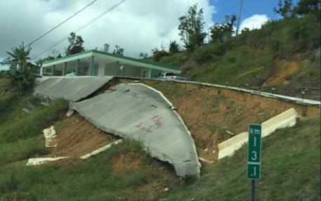
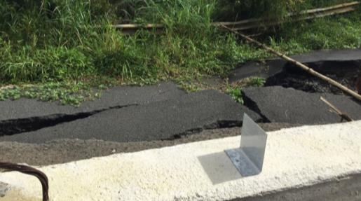
3 CONCLUSIONS OF FIELD RECON JANUARY AND MARCH For large commercial structures and high-rise residential, building maintenance, window type and window coverings (storm shutters) appeared to be the three largest factors governing whether or not these buildings were inhabitable. For structures not operational, it is assumed that high floor window damage led to large amounts of water intrusion, which thereafter manifested large quantities of mold. In these buildings, the repair of the structure as well as replacement of nearly all contents is a meaningful factor for extended downtime. 4. Widespread infrastructure damage, particularly to electric power utility assets outside of San Juan, was readily apparent in January. By March, although power restoration was seen across much of the island, old damaged and destroyed infrastructure remained visible. Debris accumulation and its removal is an increasingly publicized issue in Puerto Rico as well as the Virgin Islands.


4 RESIDENTIAL DAMAGE TRENDS ROOF FAILURES FREQUENT FOR OLDER CONSTRUCTION 155 mph ~Cat mph Cat mph Cat 3 Roof failures common for older, non-reinforced concrete and mixed construction residential structures. 140 mph Cat mph Cat 2


 fared well")

5 RESIDENTIAL STRUCTURES MIXED CONSTRUCTION WERE MORE DAMAGEABLE 155mph ~Cat feet of storm surge 120 mph Cat mph Cat mph Cat 4 Newer construction with bunker style homes (see middle left) fared well even at category 4 winds. 155 mph Cat mph Cat mph Cat 3


6 GOLF COURSE & CLUB HOUSE PALMAS DEL MAR 155mph ~Cat 5 Widespread clay tile roof damage, soffit damage with roof/wall connection compromised, cladding and tree damage. 155mph ~Cat 5 155mph ~Cat 5 Storm surge of 3-4 feet at coastal areas largely undetected 4 months post landfall 155mph ~Cat 5


7 HOTELS & TALL/LARGE COMMERCIAL FARAJDO & OLD SAN JUAN 6 feet of surge Extreme variability in damage within close distance. Building maintenance and advanced preparedness appeared to be key factors in determining speed of recovery. 110 mph Cat 2 building to on top of hill


8 HOTELS OLD SAN JUAN & CONDADO BEACH 130mph Cat 3 Within 1 mile in Condado Beach, hotel damage ranged from fully operational to expectations of full limits loss with downtime expectations of 1 year. Building age and additional efforts beyond code likely play a strong role in estimating total downtime. 110 mph Cat 2


9 HIGH-RISE COMMERCIAL 10 STORIES HIGH ~ AN ADDITIONAL 25 MPH WINDS 120 mph Cat 3 120mph Cat 3 Window damage and boarded up windows both 4 and 6 months post-maria were more frequently seen at higher floors of buildings. Most buildings appeared operational if not fully repaired four months post landfall. 125 mph ~Cat 3


10 MULTI-FAMILY DWELLING HIGHEST QUALITY CONSTRUCTION FARED WELL 110 mph ~Cat 2 Heavily reinforced concrete ( bunker-style ) construction fared best with reinforced walls, concrete slab roofs, and adequate protection for windows from air missiles. Older construction saw frequent damage to higher floor balconies and building cladding. 130 mph ~Cat mph ~Cat mph ~Cat 3


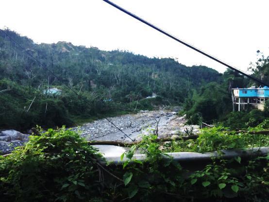
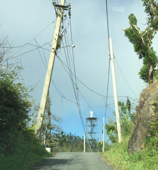
11 INFRASTRUCTURE CAT 3 AND ABOVE; MAJOR DESTRUCTION OF INFRASTRUCTURE 150 mph Cat 4 Destroyed water tower 155 mph Cat 4 Category 3+ winds left downed electrical power distribution system components in most locations, particularly outside of San Juan Metro. Category 4-5 winds snapped concrete poles in half. 125 mph Cat mph Cat mph Cat mph Cat 4


12 INFRASTRUCTURE ~80% OF STOPLIGHTS ON TRIP WERE NOT FUNCTIONAL 135 mph Cat mph Cat 3 Four months after landfall, the majority of stoplights were not functional except in downtown San Juan. The majority of highway signs on the island were damaged as well as municipal infrastructure such as baseball stadiums and the San Juan Natatorium (Olympic size swimming facility). 120 mph Cat mph Cat 3


13 STORM SURGE NOT A MAJOR DRIVER OF LOSS 3-4 feet 5-6 feet 5-6 feet


14 AIR BORNE MISSILE DAMAGE COMMON AT CATEGORY 4 AND 5 WINDS 155 mph ~ Cat mph ~ Cat mph ~ Cat mph ~ Cat 3


15 GAS STATIONS NOTORIOUSLY THE MOST DAMAGEABLE STRUCTURES TO WIND 120 mph Cat mph Cat 4 While gasoline station canopies were damaged in nearly all instances, no canopies were seen completely blown over. This stands in contrast to the US where this can be seen with category 1 or 2 storms in the past 20 years. 125 mph Cat mph Cat 4


16 RETAIL WIDESPREAD INDICATIONS OF BUILDING DAMAGE 150 mph Cat mph Cat 3 Significant deterioration of retail facilities occurred beyond maximum sustained winds of 125 miles. Those exposed to high-end category 4 winds or higher were not operational. Shingle style roof on McDonalds above average damage for region. 135 mph Cat 3


17 RETAIL CLAY TILE ROOFS DAMAGE ESCALATES CAT 3 AND HIGHER 140 mph Cat mph Cat 4 Age of retail construction, roof type and shape, as well as local businesses were primary attributes in damage potential. 4 out of 6 Walgreens surveyed on the island in late January were operational. 155 mph Cat mph Cat mph Cat 2


18 PHARMA/TECHNOLOGY (LIGHT INDUSTRIAL) ON-SITE POWER GENERATION AND EQUIPMENT PREVALENT 150 mph Cat 4 Of the 10 pharmaceutical and major manufacturing facilities surveyed in late January, all were operational. Nearly half had temporary roadside power generation, water, or gasoline trucks to aid in operations.


19 PHARMA/TECHNOLOGY (LIGHT INDUSTRIAL) OPERATIONS WERE BACK ONLINE WITH SOME CAPACITY 150 mph Cat mph Cat 4 While facilities were largely operational, older construction still had building damage that had yet to be fully repaired. Multiple instances of large piles of debris from interior contents and destroyed roof equipment was prevalent on these properties.


20 INDUSTRIAL FACILITIES PRODUCTIVITY NOTED EVEN WITH DAMAGE 125 mph Cat 3 Similar to homes, any construction featuring light metal elements sustained visible if not structural damage whereas facilities with concrete roofs fared well. Full BI losses not anticipated due to recovery of individual facilities.


21 INDUSTRIAL/ENERGY WIDESPREAD DEVASTATION AT CAT 3-5 WINDS mph Cat 4 The second largest solar plant in the Caribbean, located in Humacao, sustained meaningful damage to at least 50% of solar panels. A wind farm on the southeast coast of ten wind turbines saw complete damage to the wind blades and in multiple instances will need full replacement. A petroleum tank farm in Humacao on the coast also saw one tank with meaningful damage (below right). 115 mph Cat mph ~Cat 5


22 DEBRIS REMOVAL MANY INFORMAL COLLECTIONS, PREDOMINANTLY ROOF EQUIPMENT 155 mph Cat 4 Most prevalent in commercial structures sustaining category 3 or higher while older homes without reinforced concrete construction saw meaningful damage at category 2 levels. 135 mph Cat mph Cat 4


23 MUDSLIDES AND FLOOD WINDS , HIGHER AT ELEVATION, RAINFALL


24 FIELD RECONNAISSANCE TRIP IN PUERTO RICO 607 KILOMETERS, 377 MILES Monday January 22, 2018 Tuesday January 23, 2018 Thursday January 25, 2018
Caribbean Tropical Cyclone Modeling
 Caribbean Tropical Cyclone Modeling Filmon Habte, PhD 2018 RAA Catastrophe Risk Management Conference Orlando, Florida February 14, 2018 Agenda Hurricane risk in the Caribbean 2017 hurricane season Lessons
The Saffir-Simpson Hurricane Wind Scale
 The Saffir-Simpson Hurricane Wind Scale The Saffir-Simpson Hurricane Wind Scale is a one to five categorization based on the hurricane's intensity at the indicated time. The scale provides examples of
Hurricane Season 2018
 Hurricane Season 2018 Mission Protect LIFE and Property (Save Lives and Livelihoods) NOAA/ National Weather Service We are NOT a 9-to-5 agency. We operate 24/7/365 serving communities. We are available
Hurricane Irma. Willis Re Hurricane Damage Survey Report. Executive Summary
 Willis Re Hurricane Damage Survey Report Hurricane Irma Willis Re s post-event field damage survey report Representatives from Willis Re spent four days in the field assessing the damage caused by Hurricane
2015 Hurricane Season BY: STORM TEAM 8 METEOROLOGIST JULIE PHILLIPS
 2015 Hurricane Season BY: STORM TEAM 8 METEOROLOGIST JULIE PHILLIPS FORECAST COLORADO STATE UNIVERSITY FORECAST IS CALLING FOR ONE OF THE LEAST ACTIVE SEASONS SINCE THE MID 20 TH CENTURY! THE OFFICIAL
Risk Assessment and Mitigation. Hurricane Checklist
 Risk Assessment and Mitigation Hurricane Checklist Hurricane Checklist Hurricanes are severe tropical storms with sustained winds of at least 74 miles per hour. Hurricane winds can reach 160 miles per
Superstorm Sandy Willis Re s post-event field damage survey preliminary report
 HURRICANE DAMAGE SURVEY REPORT event November 8, 2012 Superstorm Sandy Willis Re s post-event field damage survey preliminary report Immediately after Sandy s landfall, representatives of Willis Re s Catastrophe
Post-Hurricane Recovery: How Long Does it Take?
 Post-Hurricane Recovery: How Long Does it Take? Implications for disaster recovery after hurricanes Harvey and Irma In the following report, BuildFax analyzed the geographic areas impacted by three of
Weather Middle School Teacher Instructions and Activity
 Weather Middle School Teacher Instructions and Activity Based on the guidelines of the Saffir-Simpson Scale for hurricane severity and the Fujita Scale for tornado damage, students will write a brief synopsis
Hurricane Irma. City of Cocoa Beach September 8 12, 2017
 Hurricane Irma City of Cocoa Beach September 8 12, 2017 Monitoring prior to landfall Expected effects What happened What went well What didn t go well Changes and improvements After Action Outline Storm
Ensuring the Building of Community Resiliency through Effective Partnership December 4, 2017 Melia Nassau Beach Valentino A. Hanna
 Ensuring the Building of Community Resiliency through Effective Partnership December 4, 2017 Melia Nassau Beach Valentino A. Hanna Sol Caribbean Presence What Occurred Mega Storms 2017 Cat 5 Hurricane
Name Earth Science Pd. Hurricanes. Directions: Read the information, view diagrams and answer the questions in the worksheet.
 Hurricanes Directions: Read the information, view diagrams and answer the questions in the worksheet. Hurricane Basics The ingredients for a hurricane include a pre-existing weather disturbance, warm tropical
Major Hurricane Matthew Briefing Situation Overview
 Major Hurricane Matthew Briefing Situation Overview THIS IS NOW A WORST CASE STORM SURGE SCENARIO Catastrophic Damage is Anticipated for Coastal Areas. Major Hurricane Matthew is still expected to move
The Tampa Bay Catastrophic Plan Presentation to CFGIS Users Group FDOT District 5 Urban Offices - Orlando July 30, 2010
 The Tampa Bay Catastrophic Plan Presentation to CFGIS Users Group FDOT District 5 Urban Offices - Orlando July 30, 2010 Brady Smith Senior Planner Tampa Bay Regional Planning Council Introduction Recent
Are You Ready For Hurricane Season? 2018 Hurricane Talk B Y : S T O R M T E A M 8 M E T E O R O L O G I S T J U L I E P H I L L I P S
 Are You Ready For Hurricane Season? 2018 Hurricane Talk B Y : S T O R M T E A M 8 M E T E O R O L O G I S T J U L I E P H I L L I P S About Me I am Currently a Weekday Meteorologist at WFLA Channel 8.
LECTURE #18: Hurricane Damage, Monitoring & Case Study
 GEOL 0820 Ramsey Natural Disasters Spring, 2018 LECTURE #18: Hurricane Damage, Monitoring & Case Study Date: 27 March 2018 I. Exam II grades now posted online o high: 98, low: 46, average: 80 (~3 points
photo courtesy of
 BRITISH VIRGIN ISLANDS REPORT TROPICAL STORM JEANNE photo courtesy of www.bviplatinum.com PREPARED BY THE DEPARTMENT OF DISASTER MANAGEMENT 1 EVENT 13 th -16 th September, 2004 TROPICAL STORM JEANNE Sequence
Chapter 16, Part Hurricane Paths. 2. Hurricane Paths. Hurricane Paths and Damage
 Chapter 16, Part 2 Hurricane Paths and Damage 1. Hurricane Paths Start over tropical water except South Atlantic and eastern South Atlantic, where water is too cold. Initially steered by easterly winds
HURRICANES. Source:
 HURRICANES Source: http://www.dc.peachnet.edu/~pgore/students/w97/matheson/hpage.htm What is a hurricane? Violent cyclonic storm that develops in the tropical region Wind speeds are > 74 mph Source: http://www.google.com/imgres?hl=en&sa=x&biw=1920&bih=955&tbm=
...TORNADO CONFIRMED NEAR SANFORD...BROADWAY...HOLLY SPRINGS AND RALEIGH IN LEE AND WAKE COUNTIES COUNTY NORTH CAROLINA...
 ...TORNADO CONFIRMED NEAR SANFORD...BROADWAY...HOLLY SPRINGS AND RALEIGH IN LEE AND WAKE COUNTIES COUNTY NORTH CAROLINA... LOCATION...SANFORD...BROADWAY...HOLLY SPRINGS AND RALEIGH IN LEE AND WAKE COUNTIES
Diagnosing the Large Swell Event Associated with the Extratropical Transition of Hurricane Florence
 Diagnosing the Large Swell Event Associated with the Extratropical Transition of Hurricane Florence Mark Willis National Hurricane Center Tropical Analysis and Forecast Branch (TAFB) Thanks to: Jack Beven,
GC Briefing. Weather Sentinel Tropical Storm Michael. Status at 8 AM EDT (12 UTC) Today (NHC) Discussion. October 11, 2018
 Today (NHC) Discussion. October 11, 2018") GC Briefing Weather Sentinel Tropical Storm Michael October 11, 2018 After making landfall as a high-end category-4 hurricane on the Florida Panhandle, Michael weakened to tropical storm status early this
GC Briefing Weather Sentinel Tropical Storm Michael October 11, 2018 After making landfall as a high-end category-4 hurricane on the Florida Panhandle, Michael weakened to tropical storm status early this
A bright flash that is produced due to electrical discharge and occurs during a thunderstorm.
 Science Mr. G/Mrs. Kelly Name: KEY Date: Inv.6.1 - That s a Fact: An Introduction to Thunderstorms, Tornadoes, and Hurricanes (pgs.92-97) 1. Define lightning. A bright flash that is produced due to electrical
WEDNESDAY 30 TH AUGUST, :57 p.m. Tropical Storm Irma forms in the Atlantic. Don t let your guard down, always #Be Ready.
 Chapter 1 - The Set Up In the days leading up to Irma a series of composed and sobering text messages, presented in truncated form below, from Department of Disaster Management warned us of the pending
Insurer-Funded Non-Profit Promotes Resilient Construction Research & Communications. Tornado Proof Near Ultimate Protection Tornado Resistant
 Who is IBHS Tornado Resistant Construction: Design Issues Plus Pros and Cons of Various Building Systems Timothy Reinhold Sr. VP for Research, Chief Engineer Insurance Institute for Business & Home Safety
Hurricanes. Cause: a low pressure storm system over warm ocean water. Effect: potential massive widespread destruction and flooding.
 Hurricanes Hurricanes Cause: a low pressure storm system over warm ocean water. Effect: potential massive widespread destruction and flooding. Hurricanes also known as: cyclone (Indian Ocean) or typhoon
Steps to Reduce the Risk of Tornado Damage in Commercial Structures
 Hanover Risk Solutions Steps to Reduce the Risk of Tornado Damage in Commercial Structures About 1,000 tornadoes occur each year in the United States, causing an average of $1.1 billion in property damage
TXWARN Tabletop Exercise: Hurricane Helen
 TXWARN Tabletop Exercise: Hurricane Helen July 31, 2015 Administrative Details In-studio participants and remote participants Situation manual Evaluations Training hours 1 In Studio: Welcome and Introductions
Daily Operations Briefing. Tuesday, October 24, :30 a.m. EDT
 Daily Operations Briefing Tuesday, October 24, 2017 8:30 a.m. EDT Significant Activity Oct 23-24 Significant Events: Response and recovery Tropical Cyclones Harvey, Irma, Maria Tropical Activity: Atlantic
Staging for Utility Personnel and Mutual Aid. 1. Hermine- Meeting dates were August 29th_31 st, 2016 and September 1st, 2016.
 Town of Havana, Fl. Response to Review of Electric Utility Hurricane Preparedness and Restoration Actions- Applies only to Hermine and Irma. Maria and Nate posed no serious threat to Havana. Staging for
DAMAGE SURVEY OF THE BINGER, OKLAHOMA TORNADO OF MAY 22, 1981
 DAMAGE SURVEY OF THE BINGER, OKLAHOMA TORNADO OF MAY 22, 1981 1. INTRODUCTION James R. McDonald, H. Scott Norville, and Timothy P. Marshall Institute for Disaster Research Texas Tech University Lubbock,
WEATHER SYSTEMS IMPACTING THE CAYMAN ISLANDS Prepared by the staff of the Cayman Islands National Weather Service
 WEATHER SYSTEMS IMPACTING THE CAYMAN ISLANDS 2008 Prepared by the staff of the Cayman Islands National Weather Service TROPICAL STORM DOLLY Formed 194 miles west of Grand Cayman July 19 th. The tropical
CHAPTER 10. TORNADOES AND WINDSTORMS
 CHAPTER 10. TORNADOES AND WINDSTORMS Wyoming, lying just west of tornado alley, is fortunate to experience less frequent and intense tornadoes than its neighboring states to the east. However, tornadoes
Tropical Cyclone Joaquin (AL112015)
") Tropical Cyclone Joaquin (AL112015) Wind and Storm Surge Event Briefing 9 October 2015 Vito Alessio Robles No.179. Col. Hda Gpe Chimalistac. Del. Álvaro Obregón. Cp 01050, México D.F. Tel: +52 (55) 5616-8161,
Tropical Cyclone Joaquin (AL112015) Wind and Storm Surge Event Briefing 9 October 2015 Vito Alessio Robles No.179. Col. Hda Gpe Chimalistac. Del. Álvaro Obregón. Cp 01050, México D.F. Tel: +52 (55) 5616-8161,
Major Hurricane Matthew Briefing Situation Overview
 Major Hurricane Matthew Briefing Situation Overview At 5 p.m. Tuesday, Category 4 Hurricane Matthew was about 860 miles South-Southeast of Mayport, Florida, moving north around 10 mph. Maximum sustained
Exploring the costs of sea level rise: should we focus on means or extremes?
 Exploring the costs of sea level rise: should we focus on means or extremes? Robert Muir-Wood Chief Research Officer, RMS AAAS Chicago Feb 16 th 2009 Change Points in Cat 3-5 Hurricane Numbers (the drivers
Superstorm Sandy What Risk Managers and Underwriters Learned
 Superstorm Sandy What Risk Managers and Underwriters Learned Gary Ladman Vice President, Property Underwriting AEGIS Insurance Services, Inc. Superstorm Sandy Change in the Weather Recent years appears
Hurricane Tracking Lab
 Hurricane Tracking Lab Background: Hurricanes are one of nature s most powerful disasters. To equal the power of a hurricane, one would have to set off about a thousand nuclear devices per second for as
Comparative Analysis of Hurricane Vulnerability in New Orleans and Baton Rouge. Dr. Marc Levitan LSU Hurricane Center. April 2003
 Comparative Analysis of Hurricane Vulnerability in New Orleans and Baton Rouge Dr. Marc Levitan LSU Hurricane Center April 2003 In order to compare hurricane vulnerability of facilities located in different
Identify levees and dams in your area and determine whether they pose a hazard to you.
 Courtesy of The Insurance Exchange Hurricanes are capable of producing winds in excess of 155 miles per hour and causing catastrophic damage to coastlines and several hundred miles inland. Additionally,
Tornadoes pose a high risk because the low atmospheric pressure, combined with high wind velocity, can:
 Tornadoes are powerful, circular windstorms that may be accompanied by winds in excess of 200 miles per hour. Tornadoes typically develop during severe thunderstorms and may range in width from several
STATUS OF HAZARD MAPS VULNERABILITY ASSESSMENTS AND DIGITAL MAPS
 JapanInternational Cooperation Agency STATUS OF HAZARD MAPS VULNERABILITY ASSESSMENTS AND DIGITAL MAPS ANGUILLA REPORT THE CARIBBEAN DISASTER EMERGENCY RESPONSE AGENCY () Table of Contents Page Preface
Cyclone Larry Fieldwork (RAMP)
") Cyclone Larry Fieldwork (RAMP) Introduction Figure 1 (right): Tropical Cyclone Larry track. Click to enlarge. Severe Tropical Cyclone Larry crossed the far north Queensland coast near Etty Bay around 7
Cyclone Larry Fieldwork (RAMP) Introduction Figure 1 (right): Tropical Cyclone Larry track. Click to enlarge. Severe Tropical Cyclone Larry crossed the far north Queensland coast near Etty Bay around 7
Where Do Hurricanes Occur?
 Where Do Hurricanes Occur? How Often Do Hurricanes Hit the U.S.? Hurricane Return Periods Hurricane return periods are the frequency at which a certain intensity of hurricane can be expected within a
Daily Operations Briefing. Sunday, October 22, :30 a.m. EDT
 Daily Operations Briefing Sunday, October 22, 2017 8:30 a.m. EDT Significant Activity Oct 21-22 Significant Events: Response and recovery Harvey, Irma, Maria; CA Wildfires Tropical Activity: Atlantic No
M8.8 MAULE EARTHQUAKE February 27, 2010
 M8.8 MAULE EARTHQUAKE February 27, 2010 MRP Engineering Summary Report March 2011 On February 27, 2010, a devastating M8.8 earthquake struck off the central coast of Chile, 105 kilometers north of Concepción,
0 1 8 STORM SEASON GUIDE
 2 0 1 8 STORM SEASON GUIDE HURRICANE PREPAREDNESS 101 When it comes to hurricanes, there s no such thing as being too prepared. The key to weathering any storm is to have the right tools. This includes
Tropical Cyclone Sandy (AL182012)
") Tropical Cyclone Sandy (AL182012) Event Briefing Caribbean Risk Managers Ltd Facility Supervisor 29 October 2012 Facility Supervisor: Caribbean Risk Managers Ltd Email: ccrif@ccrif.org Tel (Barbados):
Tropical Cyclone Sandy (AL182012) Event Briefing Caribbean Risk Managers Ltd Facility Supervisor 29 October 2012 Facility Supervisor: Caribbean Risk Managers Ltd Email: ccrif@ccrif.org Tel (Barbados):
TROPICAL DEPRESSION HARVEY BRIEFING
 TROPICAL DEPRESSION HARVEY BRIEFING 10:15 PM CDT Wednesday, August 23, 2017 Prepared by: Lara Beal NWSCorpus www.weather.gov/corpuschristi Situation Overview No changes to Watches. Hurricane Watch remains
Earthquakes. & Expansive Soils
 Earthquakes & Expansive Soils January 22, 2009 Plan Update Flanagan & Associates, LLC Consultants Tulsa, OK www.rdflanagan.com rdflanagan@rdflanagan.com Plan can be reviewed at: www.rdflanagan.com/.html
Tropical Cyclone Hazards. Presentation
 Tropical Cyclone Hazards Presentation Kerry N Mallory AE5JY September 7, 2011 Tropical Cyclone Hazards The Four Primary Weapons of a Tropical Cyclone are: 1. Wind 2. Storm Surge 3. Rain/Freshwater Flooding
Daily Operations Briefing. Monday, October 30, :30 a.m. EDT
 Daily Operations Briefing Monday, October 30, 2017 8:30 a.m. EDT Significant Activity Oct 28-30 Significant Events: Response and Recovery Tropical Cyclones Harvey, Irma, and Maria Severe Weather Northeast
CLIMATE READY BOSTON. Climate Projections Consensus ADAPTED FROM THE BOSTON RESEARCH ADVISORY GROUP REPORT MAY 2016
 CLIMATE READY BOSTON Sasaki Steering Committee Meeting, March 28 nd, 2016 Climate Projections Consensus ADAPTED FROM THE BOSTON RESEARCH ADVISORY GROUP REPORT MAY 2016 WHAT S IN STORE FOR BOSTON S CLIMATE?
A HURRICANE IS COMING. Presented by Atiba Upchurch Broward Emergency Management Division
 A HURRICANE IS COMING Presented by Atiba Upchurch Broward Emergency Management Division Mission Statement To safeguard the lives and property of the people of Broward County from major hazards and emergencies
Draft for Discussion 11/11/2016
 Coastal Risk Consulting (CRC) Climate Vulnerability Assessment for Village of Key Biscayne Deliverable 1.1 in Statement of Work. Preliminary Vulnerability Assessment Identifying Flood Hotspots Introduction...
Daily Operations Briefing. Tuesday, November 7, :30 a.m. EST
 Daily Operations Briefing Tuesday, November 7, 2017 8:30 a.m. EST Significant Activity Nov 6-7 Significant Events: Tropical Cyclones Harvey, Irma, and Maria Tropical Activity: Atlantic Tropical Storm Rina
COMMUNITY EMERGENCY RESPONSE TEAM TORNADOES
 Tornadoes are powerful, circular windstorms that may be accompanied by winds in excess of 200 miles per hour. Tornadoes typically develop during severe thunderstorms and may range in width from several
Section 10: Tornadoes
 Contents Section 10: Tornadoes Why Tornadoes Are a Threat...10-1 Hazard Profile...10-4 History of Tornadoes...10-5 People and Property at Risk... 10-13 Potential Damages and Losses... 10-14 Why Tornadoes
Hurricanes and coastal storms pose a risk because powerful winds and storm surges can:
 HURRICANES A hurricane is a violent area of low pressure forming in the tropical Atlantic Ocean from June to November. August and September are peak months. (Similar Western Pacific Ocean storms are called
5/25/2017. What is projected for Coastal texas? PROTECTING CRITICAL WATER INFRASTRUCTURE FROM SEA LEVEL RISE
 PROTECTING CRITICAL WATER INFRASTRUCTURE FROM SEA LEVEL RISE What is projected for Coastal texas? Mean Sea Level has risen 3 18 to 37 above Mean Sea Level 1800-1992 1992-2015 2030 2060 2100 Mean Sea Level
NATURAL FORCE THREATS, MONITORING AND RESEARCH NEEDS
 NATURAL FORCE THREATS, MONITORING AND RESEARCH NEEDS 1 Southern California Thomas Fire and Montecito Debris Flows 2 Timeline/Description of Conditions Between December 4, 2017 and January 12, 2018, over
Hurricane Preparedness and Awareness!
 Hurricane Preparedness and Awareness! Check these out Time to begin executing the evacuation plan What kind of damage are we talking about here? What Exactly Is a Hurricane? A hurricane can best be described
LECTURE #17: Severe Weather: Introduction to Hurricanes
 GEOL 0820 Ramsey Natural Disasters Spring, 2018 LECTURE #17: Severe Weather: Introduction to Hurricanes Date: 15 March 2018 I. Hurricane Overview hurricanes o what they are? o how they form? storm stages:
HURRICANES IRMA AND MARIA
 EXECUTIVE SUMMARY HURRICANES IRMA AND MARIA Bloomberg Philanthropies USVI Hurricane Recovery and Resilience Task Force 1 Hurricanes Irma and Maria, both Category 5 storms with wind gusts of up to 178 MPH
Advisory #35 Briefing 630 PM EDT Thursday October 06, 2016
 Advisory #35 Briefing 630 PM EDT Thursday October 06, 2016 Disclaimer: The information contained within this briefing is time-sensitive, do not use beyond 6 hours after the issuance Next Webinar Update:
Tornadoes. Tornadoes COMMUNITY EMERGENCY RESPONSE TEAM TORNADOES
 Tornadoes Tornadoes Tell the participants that tornadoes are powerful, circular windstorms that may be accompanied by winds in excess of 200 miles per hour. Tornadoes typically develop during severe thunderstorms
Daily Operations Briefing. Thursday, October 26, :30 a.m. EDT
 Daily Operations Briefing Thursday, October 26, 2017 8:30 a.m. EDT Significant Activity Oct 25-26 Significant Events: Response and recovery Tropical Cyclones Harvey, Irma and Maria Tropical Activity: Atlantic
HURRICANE CHARLEY CHARACTERISTICS and STORM TIDE EVALUATION
 HURRICANE CHARLEY CHARACTERISTICS and STORM TIDE EVALUATION By Robert Wang, Michael Manausa And Jenny Cheng Sponsored by Florida Department of Environmental Protection, Bureau of Beaches and Coastal Systems
HURRICANE JEANNE CHARACTERISTICS and STORM TIDE EVALUATION
 HURRICANE JEANNE CHARACTERISTICS and STORM TIDE EVALUATION ((DRAFT)) By Robert Wang and Michael Manausa Sponsored by Florida Department of Environmental Protection, Bureau of Beaches and Coastal Systems
Development and Implementation of the Japanese Enhanced Fujita Scale
 Development and Implementation of the Japanese Enhanced Fujita Scale May 2018 Japan Meteorological Agency (JMA) The Japan Meteorological Agency released its Guidelines for the Japanese Enhanced Fujita
The AIR Tropical Cyclone Model for the Carribean
 The AIR Tropical Cyclone Model for the Carribean In October 212, Hurricane Sandy wreaked havoc across Jamaica, Cuba, and the Bahamas. The AIR Tropical Cyclone Model for the Caribbean incorporates the latest
AIR Tropical Cyclone Model for the Caribbean
 AIR Tropical Cyclone Model for the Caribbean In October 212, Hurricane Sandy wreaked havoc across Jamaica, Cuba, and the Bahamas. The AIR Tropical Cyclone Model for the Caribbean incorporates the latest
Hurricane KATRINA Lessons Learned for Managing Risk
 Hurricane KATRINA Lessons Learned for Managing Risk Steven L. Stockton, P.E. Deputy Director of Civil Works U.S. Army Corps of Engineers What Happened? Storm Path from August 23 to 31, 2005 Mon. August
Hurricane Matthew. National Weather Service Wilmington NC. Steven Pfaff, WCM.
 Hurricane Matthew Threat Assessment for northeast South Carolina & southeast North Carolina National Weather Service Wilmington NC 730 AM EDT Tuesday October 4, 2016 Steven Pfaff, WCM Steven.Pfaff@noaa.gov
CHAPTER FIVE: THE LOWER MISSISSIPPI REGION AND PLAQUEMINES PARISH
 CHAPTER FIVE: THE LOWER MISSISSIPPI REGION AND PLAQUEMINES PARISH 5.1 Overview Plaquemines Parish is the area where the last portion of the Mississippi River flows out into the Gulf of Mexico (see Figures
Tropical Activity. Atlantic Hurricane Florence (CAT 4)
") Tropical Activity Atlantic Hurricane Florence (CAT 4) As of 8 a.m. ET Tuesday, Florence's center had maximum sustained winds of 130 mph and was about 950 miles east-southeast of Cape Fear, North Carolina.
Tropical Activity Atlantic Hurricane Florence (CAT 4) As of 8 a.m. ET Tuesday, Florence's center had maximum sustained winds of 130 mph and was about 950 miles east-southeast of Cape Fear, North Carolina.
CURRENT AND FUTURE TROPICAL CYCLONE RISK IN THE SOUTH PACIFIC
 CURRENT AND FUTURE TROPICAL CYCLONE RISK IN THE SOUTH PACIFIC COUNTRY RISK PROFILE: SAMOA JUNE 2013 Samoa has been affected by devastating cyclones on multiple occasions, e.g. tropical cyclones Ofa and
Daily Operations Briefing. Sunday, October 29, :30 a.m. EDT
 Daily Operations Briefing Sunday, October 29, 2017 8:30 a.m. EDT Significant Activity Oct 28-29 Significant Events: Response and Recovery Tropical Cyclones Harvey, Irma, and Maria Tropical Activity: Atlantic
Electric Distribution Storm Hardening Initiatives. Paul V. Stergiou Distribution Engineering October 14 th, 2015
 Consolidated Edison Company of New York, Inc. Electric Distribution Storm Hardening Initiatives Paul V. Stergiou Distribution Engineering October 14 th, 2015 Energy For New York City And Westchester 3.3
Daily Operations Briefing. Sunday, September 24, :30 a.m. EDT
 Daily Operations Briefing Sunday, September 24, 2017 8:30 a.m. EDT Significant Activity Sep 23-24 Significant Events: Response for Hurricane Maria Tropical Activity: Atlantic Hurricane Maria (CAT 2); Hurricane
Your Task: Read each slide then use the underlined red or underlined information to fill in your organizer.
 Severe Weather: Tornadoes and Hurricanes Thunderstorms and Lightning S6E4 d. Construct an explanation of the relationship between air pressure, weather fronts, and air masses and meteorological events
Application #: TEXT
 TOWN OF FORT MYERS BEACH 2008 PROPOSED COMPREHENSIVE PLAN AMENDMENTS Application #: 2008-13-TEXT Description: Modify the Coastal Management and Future Land Use Elements to reflect the state s new definition
Welcome Jeff Orrock Warning Coordination Meteorologist National Weather Service Raleigh
 Welcome Jeff Orrock Warning Coordination Meteorologist National Weather Service Raleigh Jeff.orrock@noaa.gov Sources: Operational Significant Event Imagery and the Environmental Applications Team (EAT)
TORNADOES. DISPLAY VISUAL A Tornado Is... Tornadoes can: Rip trees apart. Destroy buildings. Uproot structures and objects.
 TORNADOES Introduce tornadoes by explaining what a tornado is. DISPLAY VISUAL A Tornado Is... A powerful, circular windstorm that may be accompanied by winds in excess of 250 miles per hour. Tell the participants
Hurricane Katrina and Oil Spills: Impact on Coastal and Ocean Environments
 Archived version from NCDOCKS Institutional Repository http://libres.uncg.edu/ir/asu/ Pine, J. C. (June 2006). Hurricane Katrina and oil spills: Impact on coastal and ocean environments. Oceanography,
US Army Corps of Engineers BUILDING STRONG
 Greater New Orleans Hurricane and Storm Damage Risk Reduction System Robert Rowlette Senior Senior Program Manager Task Force Hope U.S. Army Corps of Engineers April 19, 2012 US Army Corps of Engineers
Tropical Cyclone Gonzalo (AL082014)
") Tropical Cyclone Gonzalo (AL082014) Event Briefing 20 October 2014 Registered Office: c/o Sagicor Insurance Managers Ltd., 103 South Church Street 1st Floor Harbour Place, P.O. Box 1087, Grand Cayman KY1-1102,
Tropical Cyclone Gonzalo (AL082014) Event Briefing 20 October 2014 Registered Office: c/o Sagicor Insurance Managers Ltd., 103 South Church Street 1st Floor Harbour Place, P.O. Box 1087, Grand Cayman KY1-1102,
NOAA s National Weather Service Philadelphia/Mt. Holly NJ
 Next Briefing Package: Friday, October 2, 2015 no later than 300 PM Hazards and Impacts: Overview: A dangerous weather pattern still threatens our region. Threats include very heavy rainfall, inland river
HURRICANES (33) Terminology: hurricane = typhoon = strong tropical cyclone.
 Terminology: hurricane = typhoon = strong tropical cyclone.") GG 454 April 9, 2002 1 HURRICANES (33) I Main Topics A Definition and characterization of hurricanes B Conditions required for hurricanes C Tornadoes vs. hurricanes D Storm surges E Case histories II Terminology
GG 454 April 9, 2002 1 HURRICANES (33) I Main Topics A Definition and characterization of hurricanes B Conditions required for hurricanes C Tornadoes vs. hurricanes D Storm surges E Case histories II Terminology
11/28/2017 MET Cyclone Tracy. David & Frederic in Hurricane Hugo in 1989
 MET 4532 Cyclone Tracy Lecture 37 Final Exam Review 6 8 December 2017 Formed on 20DEC74, 500 km NE of Darwin Became visible on Darwin Radar on the 22 nd as a 50 m/s cyclone Slowed and tracked around Bathurst
Hurricane Matthew Threats and Impacts Briefing for Eastern NC
 Hurricane Matthew Threats and Impacts Briefing for Eastern NC October 6 th, 2016 Date/Time Created: 10/6/2016, Noon EDT National Weather Service Newport/Morehead City, NC Hurricane Matthew Key Points Changes
What the Science Tells Us & How Practitioners Can Use the Science
 What the Science Tells Us & How Practitioners Can Use the Science Presented at APTA Los Angeles, CA Presented by Dr. B. Tod Delaney President, First Environment, Inc. Wed. August 3, 2011 1 Agenda 1. What
October By Kimberly Paarlberg, RA, Senior Staff Architect and Dave Bowman, Manager of Codes, ICC
 45 Be Prepared to Weather the Storm New Scoping in the 2015 IBC for Storm Shelters Using the ICC 500 ICC/NSSA Standard for the Design and Construction of Storm Shelters By Kimberly Paarlberg, RA, Senior
Tropical Update. 5 AM EDT Tuesday, September 12, 2017 Post-Tropical Cyclone Irma, Hurricane Jose, & Tropical Wave (10%)
") Tropical Update 5 AM EDT Tuesday, September 12, 2017 Post-Tropical Cyclone Irma, Hurricane Jose, & Tropical Wave (10%) This update is intended for government and emergency response officials, and is provided
Tropical Update 5 AM EDT Tuesday, September 12, 2017 Post-Tropical Cyclone Irma, Hurricane Jose, & Tropical Wave (10%) This update is intended for government and emergency response officials, and is provided
AN ENGINEERING ANALYSIS OF THE GRAND ISLAND, NE TORNADOES
 (Presented at the 12th Conf. on Severe Local Storms, San Antonio, Texas, January 1982, p. 293-296). AN ENGINEERING ANALYSIS OF THE GRAND ISLAND, NE TORNADOES Timothy P. Marshall and James R. McDonald Institute
How to Prepare for a Tornado
 Tornadoes Tornadoes How to Prepare for a Tornado Special Precautions for Mobile Home Dwellers What to Do During a Tornado Warning Responses After a Tornado Inspecting Buildings for Hidden Wind Damage Special
Director, Operations Services, Met-Ed
 Director, Operations Services, Met-Ed Pennsylvania House Republican Policy Committee Hearing on Storm Response Tobyhanna Township Municipal Building Pocono Pines, Pa. August 9, 2018 Planning and Forecast
Research Report. Hurricane Sandy. 20F Science Extreme Weather. October, By: November 5th, 2013 Period 6 20F Science Submitted to: Miss Brunel
 20F Science Extreme Weather Research Report Hurricane Sandy October, 2012 By: November 5th, 2013 Period 6 20F Science Submitted to: Miss Brunel Table of Contents 1.0 Introduction... 2 2.0 Summary of [Hurricanes]...
...TORNADO CONFIRMED NEAR SANFORD...BROADWAY...HOLLY SPRINGS AND RALEIGH IN LEE AND WAKE COUNTIES COUNTY NORTH CAROLINA...
 ...TORNADO CONFIRMED NEAR SANFORD...BROADWAY...HOLLY SPRINGS AND RALEIGH IN LEE AND WAKE COUNTIES COUNTY NORTH CAROLINA... LOCATION...SANFORD...BROADWAY...HOLLY SPRINGS AND RALEIGH IN LEE AND WAKE COUNTIES
Daily Operations Briefing. Thursday, September 21, :30 a.m. EDT
 Daily Operations Briefing Thursday, September 21, 2017 8:30 a.m. EDT Significant Activity Sep 20-21 Significant Events: Response for Hurricane Maria Tropical Activity: Atlantic Tropical Storm Jose; Hurricane