Remote Sensing Techniques for Renewable Energy Projects. Dr Stuart Clough APEM Ltd
|
|
|
- Brian Willis
- 6 years ago
- Views:
Transcription

1 Remote Sensing Techniques for Renewable Energy Projects Dr Stuart Clough APEM Ltd

2 What is Remote Sensing? The use of aerial sensors to detect and classify objects on Earth Remote sensing for ecological applications essentially focuses on the classification of either habitats or of the species themselves

3 Remote Sensing for Renewables - examples Habitat mapping for linear assets such as onshore cable routes from offshore devices Very high resolution imagery of potential routes from landfall to substation Automated classification into land cover types Allows route selection to be refined, fewer landowner contacts Allows for ground surveying to be targeted

4 Remote Sensing for Renewables - examples Habitat mapping for hydropower projects Very high resolution imagery of river channels Automated extraction of water depth and grain size maps, and fish habitat maps Allows for detailed assessment of sediment transport issues Allows effect of changes in flow to be quantified


5 Remote Sensing for Renewables - examples 3D Terrain Mapping - automated digital terrain model extraction from stereo imaging

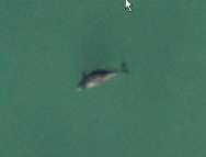
6 Remote Sensing for Renewables - examples Thermal imaging of seals for marine renewables projects abundance, distribution and habitat use
7 Case Study the evolution of remote sensing techniques for offshore wind studies Historically most studies used observer based methods from either a vessel or aircraft platform Used statistical methods to correct for reduced detection ability with distance from the platform The problem with boats some birds are attracted, others are repelled, cause disturbance (high % in flight), post construction bias, unquantifiable error The problem with visual aerial health and safety (200ft), disturbance, post construction bias, unquantifiable error Improvements in sensor technology meant these problems could be overcome
8 Benefits of the switch to digital Operational benefits Health & Safety; survey altitude, less time at sea Survey design consistent; no change post-construction More flexible - responsive to weather windows Cheaper than boat based surveys Biological benefits No disturbance to animals being surveyed Statistical benefits No attraction / repulsion from platform Allows randomised designs (the image is a quadrat!) Quicker reduced effect of temporal change Data can be matched to environmental gradients for modelling Error is quantifiable, population change can be measured Confidence Fully auditable, quality assurance Fully objective; human error reduced
 and very high resolution")
9 Technology continues to improve Moores law 60 megapixels First camera system to provide forward motion compensation on 2 axes: Stability and accuracy Multispectral (RGB and NIR bands) and very high resolution Leica RCD30
10 Survey design Case-by case-basis Consider site, species, consenting risks How best to answer the questions Specialist software plots flight lines and nodes Camera only fires when target location reached
11 Survey approach: Grid-based survey Back to first principles Classic design quadrat style Independent samples of population Statistically more powerful than transect based methods Trade off between percentage coverage and processing cost
12
13 Project specific outputs: Which species are present? Distribution and abundance? Bird flight altitude Proportion of adults/juveniles Direction of bird movement (SPA linked?) Population estimates

14 Example images - high resolution
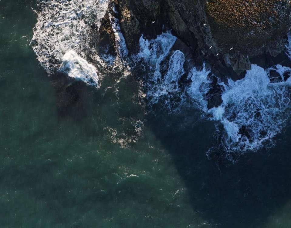
15

16


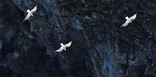
17 Automated image analysis Automated Object Recognition Bird wing span and body length Bird flight direction Bird flight height

18 Example GIS Output
 External independent QA BTO and")
19 Quality Assurance APEM image assessment by trained observers Number of birds/marine mammals Grouping/species Individual Position (GIS based) External independent QA BTO and SMRU

20 UKAS Accreditation UKAS accredited for the Identification & Enumeration of Birds from Aerial Photographs Extension of existing Lab Accreditation Ensures Quality of Results Ensures Reproducibility & Traceability Drives continuous improvements Evidence of high standards client and regulator confidence in our data
 Camera Bird")
 Surface")
21 Additional outputs - bird flight height Altitude of Aircraft (known) Camera Bird Altitude (calculated) Bird Resolution (Calculated from average size) Surface Resolution (known)
22 Additional outputs - flight direction & SPA connectivity Individual birds are georeferenced Bearing is automatically determined from headtail axis Extraction to GIS Rose diagrams produced for defined areas
23 Statistical methods for population estimates Generalised Additive Models (GAMs): Method of fitting a smooth relationship between two or more variables to assess complex relationships. Geographical, physical and environmental covariates used to inform model E ( s j ) exp 0 fk ( z jk ) k Where Ѳ 0 is the intercept, f k are smoothed functions of the explanatory covariates, and z jk is the value of the k th explanatory covariate in the j th group Fitted with a suitable error distribution to cope with the non-parametric nature of counts
 are spatially joined to the")
24 Data preparation A template grid is created, with an appropriate cell size to cover entire survey area Cell size chosen to minimise the number of assumptions about the spatial distribution of individuals Environmental parameters (depth, X, Y, and distance to shoreline/spas) are spatially joined to the survey grid

25 GAM outputs 5 km 25
26 GAM outputs Animal abundance within each cell predicted by a GAM based on significant environmental parameters GAM-derived values spatially joined to the template grid to create GAM prediction maps for individual bird groups/season and imported into ArcGIS Enables sensitive planning of renewable energy projects as well as population estimates / distribution

27 Conclusions Sensor technology continues to improve New sensors and better sensor resolution will result in new applications Remote sensing produces a permanent record and statistically robust, auditable data Expert ecological interpretation will always be required Remote sensing will have an increasing role in ecology and environmental management projects in the future


28 Thank you Dr Stuart Clough Director APEM Limited Tel: (0161)
Renewable Energy Development and Airborne Wildlife Conservation
 Whitepaper ECHOTRACK TM RADAR ACOUSTIC TM SURVEILLANCE SYSTEM Renewable Energy Development and Airborne Wildlife Conservation Renewable energy developers must meet regulatory requirements to mitigate for
Global UAV-based solutions for the industry and agriculture.
 Global UAV-based solutions for the industry and agriculture. Remote sensing of vegetation from drones (UAS). The example of the Trimble Unmanned Aerial Solution Emmanuel de Maistre, co-founder & CEO demaistre@redbird.fr
Mermaid. The most sophisticated marine operations planning software available.
 Mermaid The most sophisticated marine operations planning software available. Mojo Maritime / Marine economic risk management aid Mermaid : marine economic risk management aid The most sophisticated marine
Imagery and the Location-enabled Platform in State and Local Government
 Imagery and the Location-enabled Platform in State and Local Government Fred Limp, Director, CAST Jim Farley, Vice President, Leica Geosystems Oracle Spatial Users Group Denver, March 10, 2005 TM TM Discussion
Alex Zerbini. National Marine Mammal Laboratory Alaska Fisheries Science Center, NOAA Fisheries
 Alex Zerbini National Marine Mammal Laboratory Alaska Fisheries Science Center, NOAA Fisheries Introduction Abundance Estimation Methods (Line Transect Sampling) Survey Design Data collection Why do we
GEOMATICS. Shaping our world. A company of
 GEOMATICS Shaping our world A company of OUR EXPERTISE Geomatics Geomatics plays a mayor role in hydropower, land and water resources, urban development, transport & mobility, renewable energy, and infrastructure
DUC 2017 Fieldwork Overview: Akaitcho Wetland Mapping Project
 DUC 2017 Fieldwork Overview: Akaitcho Wetland Mapping Project Prepared for MobileDemand Project Managers: Kevin Smith, Al Richard Lead Technical Analyst: *Michael Merchant Support Analysts: Becca Warren,
INSTITUTE OF AERONAUTICAL ENGINEERING (Autonomous) Dundigal, Hyderabad
 Dundigal, Hyderabad") INSTITUTE OF AERONAUTICAL ENGINEERING (Autonomous) Dundigal, Hyderabad -00 0 CIVIL ENGINEERING TUTORIAL QUESTION BANK Course Name : Remote Sensing and GIS Course Code : A00 Class : IV B. Tech I Semester
INSTITUTE OF AERONAUTICAL ENGINEERING (Autonomous) Dundigal, Hyderabad -00 0 CIVIL ENGINEERING TUTORIAL QUESTION BANK Course Name : Remote Sensing and GIS Course Code : A00 Class : IV B. Tech I Semester
Site Investigations for Offshore Wind
 Site Investigations for Offshore Wind A multi-disciplinary approach Mattijs de Lange Gardline Marine Sciences Limited My thanks to: Maarten Timmerman David Cerda Saltzman Sue Crothers Albert van der Hem
TABLE 1 SSFL CHEMICAL SOIL BACKGROUND STUDY DATA QUALITY OBJECTIVES
 Problem Statement: Soil chemical concentration data for selected constituents are needed from off-site chemical background reference areas (CBRAs) to establish a regulatory-compliant, publicly-reviewed,
Kyoto and Carbon Initiative - the Ramsar / Wetlands International perspective
 Kyoto and Carbon Initiative - the Ramsar / Wetlands International perspective (the thoughts of Max Finlayson, as interpreted by John Lowry) Broad Requirements Guideline(s) for delineating wetlands (specifically,
The next generation in weather radar software.
 The next generation in weather radar software. PUBLISHED BY Vaisala Oyj Phone (int.): +358 9 8949 1 P.O. Box 26 Fax: +358 9 8949 2227 FI-00421 Helsinki Finland Try IRIS Focus at iris.vaisala.com. Vaisala
Ramani Geosystems. Putting Africa On The Map. Authorized Resellers
 Ramani Geosystems Putting Africa On The Map Authorized Resellers Ramani Profile Started in 1999 Aerial, Land Surveying & Mapping Solutions + 10 Countries in the region + 80 Staff working in projects Asset
GIS Workshop Data Collection Techniques
 GIS Workshop Data Collection Techniques NOFNEC Conference 2016 Presented by: Matawa First Nations Management Jennifer Duncan and Charlene Wagenaar, Geomatics Technicians, Four Rivers Department QA #: FRG
Introduction to Part III Examining wildlife distributions and abundance using boat surveys
 Baseline Wildlife Studies in Atlantic Waters Offshore of Maryland: Final Report to the Maryland Department of Natural Resources and Maryland Energy Administration, 2015 Introduction to Part III Examining
Technical Drafting, Geographic Information Systems and Computer- Based Cartography
 Technical Drafting, Geographic Information Systems and Computer- Based Cartography Project-Specific and Regional Resource Mapping Services Geographic Information Systems - Spatial Analysis Terrestrial
Applications of GIS in assessing Coastal Change Rachel Hehre November 30, 2004 NRS 509 OVERVIEW
 Applications of GIS in assessing Coastal Change Rachel Hehre November 30, 2004 NRS 509 OVERVIEW ITRODUCTION Due to the dynamic nature of coastal systems, representing coastal change with precision and
Environmental Risk from Ship traffic along the Norwegian Coast Odd Willy Brude, Det Norske Veritas, Veritasveien 1, 1322 Høvik, Norway
 Environmental Risk from Ship traffic along the Norwegian Coast 15.02.2012 Odd Willy Brude, Det Norske Veritas, Veritasveien 1, 1322 Høvik, Norway Marte Braathen, Det Norske Veritas, Veritasveien 1, 1322
VISUALIZING THE SMART CITY 3D SPATIAL INFRASTRUCTURE GEOSMART ASIA- 30 SEP, 2015
 www.aamgroup.com VISUALIZING THE SMART CITY 3D SPATIAL INFRASTRUCTURE GEOSMART ASIA- 30 SEP, 2015 Agenda AAM What is a Smart City? Data Acquisition 3D Modelling Benefits Questions AAM AAM is a Geospatial
MUDMAP TM. Software Description
 ASA Applied Science Associates, Inc. 70 Dean Knauss Drive Narragansett, RI 02882-1143 U.S.A. Tel: 401-789-6224 Fax: 401-789-1932 asa@asascience.com www.asascience.com MUDMAP TM Software Description MUDMAP
Photogeology In Terrain Evaluation (Part 1) Prof. Javed N Malik. Department of Earth Sciences Indian Institute of Technology, Kanpur
 Prof. Javed N Malik. Department of Earth Sciences Indian Institute of Technology, Kanpur") Photogeology In Terrain Evaluation (Part 1) Prof. Javed N Malik. Department of Earth Sciences Indian Institute of Technology, Kanpur Lecture 01 Introduction to Remote Sensing Photogeology Hello everybody.
Photogeology In Terrain Evaluation (Part 1) Prof. Javed N Malik. Department of Earth Sciences Indian Institute of Technology, Kanpur Lecture 01 Introduction to Remote Sensing Photogeology Hello everybody.
Measurement and Instrumentation, Data Analysis. Christen and McKendry / Geography 309 Introduction to data analysis
 1 Measurement and Instrumentation, Data Analysis 2 Error in Scientific Measurement means the Inevitable Uncertainty that attends all measurements -Fritschen and Gay Uncertainties are ubiquitous and therefore
OFFSHORE. Advanced Weather Technology
 Contents 3 Advanced Weather Technology 5 Working Safely, While Limiting Downtime 6 Understanding the Weather Forecast Begins at the Tender Stage 7 Reducing Time and Costs on Projects is a Priority Across
Mapping Coastal Change Using LiDAR and Multispectral Imagery
 Mapping Coastal Change Using LiDAR and Multispectral Imagery Contributor: Patrick Collins, Technical Solutions Engineer Presented by TABLE OF CONTENTS Introduction... 1 Coastal Change... 1 Mapping Coastal
Lesson 4b Remote Sensing and geospatial analysis to integrate observations over larger scales
 Lesson 4b Remote Sensing and geospatial analysis to integrate observations over larger scales We have discussed static sensors, human-based (participatory) sensing, and mobile sensing Remote sensing: Satellite
USING HYPERSPECTRAL IMAGERY
 USING HYPERSPECTRAL IMAGERY AND LIDAR DATA TO DETECT PLANT INVASIONS 2016 ESRI CANADA SCHOLARSHIP APPLICATION CURTIS CHANCE M.SC. CANDIDATE FACULTY OF FORESTRY UNIVERSITY OF BRITISH COLUMBIA CURTIS.CHANCE@ALUMNI.UBC.CA
Sensors & Transducers Published by IFSA Publishing, S. L., 2016
 Sensors & Transducers Published by IFSA Publishing, S. L., 2016 http://www.sensorsportal.com Ice Detection of Pure and Saline Ice Using Infrared Signature 1 Taimur Rashid, Hassan A. Khawaja and K. Edvardsen
CLICK HERE TO KNOW MORE
 CLICK HERE TO KNOW MORE GENERALIZATION OF TOPOGRAPHIC DATABASE FOR SERVING GEOSPATIAL DATA FOR MILITARY AND SOCIO-ECONOMIC TASKS IN VIETNAM Speaker: Lieutenant Colonel, Nguyen Dinh Minh GENERAL STAFF -
Weather Technology in the Cockpit (WTIC) Program Program Update. Friends/Partners of Aviation Weather (FPAW) November 2, 2016
 Program Program Update. Friends/Partners of Aviation Weather (FPAW) November 2, 2016") Weather Technology in the Cockpit (WTIC) Program Program Update Friends/Partners of Aviation Weather (FPAW) November 2, 2016 Presented by Gary Pokodner, WTIC Program Manager Phone: 202.267.2786 Email:
Weather Technology in the Cockpit (WTIC) Program Program Update Friends/Partners of Aviation Weather (FPAW) November 2, 2016 Presented by Gary Pokodner, WTIC Program Manager Phone: 202.267.2786 Email:
1. Omit Human and Physical Geography electives (6 credits) 2. Add GEOG 677:Internet GIS (3 credits) 3. Add 3 credits to GEOG 797: Final Project
 2. Add GEOG 677:Internet GIS (3 credits) 3. Add 3 credits to GEOG 797: Final Project") The Department of Geography and the Office of Professional Studies propose to modify the Master of Professional Studies in Geospatial Information Sciences (GIS) as follows: 1. Omit Human and Physical Geography
The Department of Geography and the Office of Professional Studies propose to modify the Master of Professional Studies in Geospatial Information Sciences (GIS) as follows: 1. Omit Human and Physical Geography
Impact of Noise on the Marine Environment a Regulatory Perspective
 Impact of Noise on the Marine Environment a Regulatory Perspective John Hartley Hartley Anderson Ltd. Photographs courtesy of JNCC Over-arching Objective Minimise the Impact of Oil and Gas Activities &
Donald K. Stauble and Bill Birkemeier Coastal and Hydraulics Laboratory US Army Corps of Engineers
 Donald K. Stauble and Bill Birkemeier Coastal and Hydraulics Laboratory US Army Corps of Engineers Define the Problem Navigation Shore Protection Environmental Political So what is the problem? Management
P R O U D LY C A N A D I A N
 P R O U D LY C A N A D I A N 1.855.423.3185 info@rmegeomatics.com AERIAL SURVEYING IMAGING TERRAIN ANALYSIS WHO WE ARE HSE & REGULATORY CLIENT INDUSTRIES RME Geomatics (formerly NGF Geomatics) was founded
The next generation in weather radar software.
 The next generation in weather radar software. PUBLISHED BY Vaisala Oyj Phone (int.): +358 9 8949 1 P.O. Box 26 Fax: +358 9 8949 2227 FI-00421 Helsinki Finland Try IRIS Focus at iris.vaisala.com. Vaisala
Scout Aerial Africa DRONES THE BIG PICTURE FOR GEOLOGY AND MINING
 Scout Aerial Africa DRONES THE BIG PICTURE FOR GEOLOGY AND MINING WHO ARE WE? Scout Aerial Group is a diversified operating and investment group with market leading businesses and targeted investment in
Approach to Field Research Data Generation and Field Logistics Part 1. Road Map 8/26/2016
 Approach to Field Research Data Generation and Field Logistics Part 1 Lecture 3 AEC 460 Road Map How we do ecology Part 1 Recap Types of data Sampling abundance and density methods Part 2 Sampling design
GEOGRAPHY (GE) Courses of Instruction
 Courses of Instruction") GEOGRAPHY (GE) GE 102. (3) World Regional Geography. The geographic method of inquiry is used to examine, describe, explain, and analyze the human and physical environments of the major regions of the
GEOGRAPHY (GE) GE 102. (3) World Regional Geography. The geographic method of inquiry is used to examine, describe, explain, and analyze the human and physical environments of the major regions of the
UAV s in Geoinformatics - Trends and Perspectives
 UAV s in Geoinformatics - Trends and Perspectives Torsten Prinz & Christian Knoth Institute for Geoinformatics (IFGI), University of Muenster (WWU) GeoNetzwerk Münsterland (29.11.2013) I. Introduction
Identifying Audit, Evidence Methodology and Audit Design Matrix (ADM)
") 11 Identifying Audit, Evidence Methodology and Audit Design Matrix (ADM) 27/10/2012 Exercise XXX 2 LEARNING OBJECTIVES At the end of this session participants will be able to: 1. Identify types and sources
11 Identifying Audit, Evidence Methodology and Audit Design Matrix (ADM) 27/10/2012 Exercise XXX 2 LEARNING OBJECTIVES At the end of this session participants will be able to: 1. Identify types and sources
Wetland Mapping. Wetland Mapping in the United States. State Wetland Losses 53% in Lower US. Matthew J. Gray University of Tennessee
 Wetland Mapping Caribbean Matthew J. Gray University of Tennessee Wetland Mapping in the United States Shaw and Fredine (1956) National Wetlands Inventory U.S. Fish and Wildlife Service is the principle
GIS = Geographic Information Systems;
 What is GIS GIS = Geographic Information Systems; What Information are we talking about? Information about anything that has a place (e.g. locations of features, address of people) on Earth s surface,
STEREO ANALYST FOR ERDAS IMAGINE Stereo Feature Collection for the GIS Professional
 STEREO ANALYST FOR ERDAS IMAGINE Stereo Feature Collection for the GIS Professional STEREO ANALYST FOR ERDAS IMAGINE Has Your GIS Gone Flat? Hexagon Geospatial takes three-dimensional geographic imaging
Chapter 6: Recommendations for high resolution digital video aerial surveys in the U.S.
 Chapter 6: Recommendations for high resolution digital video aerial surveys in the U.S. Final Report to the Department of Energy Wind and Water Power Technologies Office, 2015 Melissa Duron, Andrew Gilbert,
Eyes in the Sky & Data Analysis.
 Eyes in the Sky & Data Analysis How can we collect Information about Earth Climbing up Trees & Mountains Gathering Food Self Protection Understanding Surroundings By Travelling Collected Information Converted
DP Project Development Pvt. Ltd.
 Dear Sir/Madam, Greetings!!! Thanks for contacting DP Project Development for your training requirement. DP Project Development is leading professional training provider in GIS technologies and GIS application
Managing bathymetric data in a hydrographic survey company
 Managing bathymetric data in a hydrographic survey company Overview Brief Introduction to MMT How MMT use GIS Why we need to manage bathy data The BIS Inputting Data to the BIS Using the BIS GIS Product
Transect width and missed observations in counting muskoxen (Ovibos moschatus) from fixed-wing aircraft
 from fixed-wing aircraft") Paper presented at The First Arctic Ungulate Conference, Nuuk, Greenland, 3-8 September, 1991. Transect width and missed observations in counting muskoxen (Ovibos moschatus) from fixed-wing aircraft P.
Paper presented at The First Arctic Ungulate Conference, Nuuk, Greenland, 3-8 September, 1991. Transect width and missed observations in counting muskoxen (Ovibos moschatus) from fixed-wing aircraft P.
Cell-based Model For GIS Generalization
 Cell-based Model For GIS Generalization Bo Li, Graeme G. Wilkinson & Souheil Khaddaj School of Computing & Information Systems Kingston University Penrhyn Road, Kingston upon Thames Surrey, KT1 2EE UK
What is GIS? Introduction to data. Introduction to data modeling
 What is GIS? Introduction to data Introduction to data modeling 2 A GIS is similar, layering mapped information in a computer to help us view our world as a system A Geographic Information System is a
14.2 Weather impacts and routing services in support of airspace management operations. David I. Knapp, Jeffrey O. Johnson, David P.
 14.2 Weather impacts and routing services in support of airspace management operations David I. Knapp, Jeffrey O. Johnson, David P. Sauter U.S. Army Research Laboratory, Battlefield Environment Division,
VCS MODULE VMD0018 METHODS TO DETERMINE STRATIFICATION
 VMD0018: Version 1.0 VCS MODULE VMD0018 METHODS TO DETERMINE STRATIFICATION Version 1.0 16 November 2012 Document Prepared by: The Earth Partners LLC. Table of Contents 1 SOURCES... 2 2 SUMMARY DESCRIPTION
ENVS S102 Earth and Environment (Cross-listed as GEOG 102) ENVS S110 Introduction to ArcGIS (Cross-listed as GEOG 110)
 ENVS S110 Introduction to ArcGIS (Cross-listed as GEOG 110)") ENVS S102 Earth and Environment (Cross-listed as GEOG 102) 1. Describe the fundamental workings of the atmospheric, hydrospheric, lithospheric, and oceanic systems of Earth 2. Explain the interactions
ENVS S102 Earth and Environment (Cross-listed as GEOG 102) 1. Describe the fundamental workings of the atmospheric, hydrospheric, lithospheric, and oceanic systems of Earth 2. Explain the interactions
Sampling. Where we re heading: Last time. What is the sample? Next week: Lecture Monday. **Lab Tuesday leaving at 11:00 instead of 1:00** Tomorrow:
 Sampling Questions Define: Sampling, statistical inference, statistical vs. biological population, accuracy, precision, bias, random sampling Why do people use sampling techniques in monitoring? How do
Coastal Inlets Research Program US Army Corps of Engineers Engineering Research and Development Center
 Coastal Inlets Research Program US Army Corps of Engineers Engineering Research and Development Center Site of Moriches Inlet Nov. 1951 Julie Dean Rosati and Nicholas C. Kraus, CIRP Program Manager Shinnecock
Visibility and present weather sensors. you can trust... visibly better
 Visibility and present weather sensors you can trust... Biral HSS sensors visibly better CONTENTS HSS Application Examples PAGE 2 (this page) APPLICATION EXAMPLES 1 (Highway and Research) TRACK RECORD
GIS-Based Sediment Quality Database for the St. Louis River Area of Concern (AOC): Overview Presentations and Demonstration
: Overview Presentations and Demonstration") GIS-Based Sediment Quality Database for the St. Louis River Area of Concern (AOC): Overview Presentations and Demonstration Judy L. Crane 1 and Dawn E. Smorong 2 1 Minnesota Pollution Control Agency, St.
GIS-Based Sediment Quality Database for the St. Louis River Area of Concern (AOC): Overview Presentations and Demonstration Judy L. Crane 1 and Dawn E. Smorong 2 1 Minnesota Pollution Control Agency, St.
GIS and conservation biology: A case study with animal movement data
 GIS and conservation biology: A case study with animal movement data BIOL 037: Conservation Genetics, week of April 22 2013 In this lab exercise we will explore bird migration data and how it can be used
Footprint Ecology Training 2016
 Footprint Ecology B USINESS NAME Training 2016 Footprint Ecology is an independent ecology consultancy based in Dorset. Our work focuses on nature conservation and in particular: recreation and wildlife
23. SUBSISTENCE USES AND TRADITIONAL KNOWLEDGE
 23. SUBSISTENCE USES AND TRADITIONAL KNOWLEDGE 23.1 Introduction The purpose of the subsistence uses and traditional knowledge study is to establish a description of subsistence uses and knowledge of local
Unmanned Aircraft Systems (UAS) Activities in Earth Sciences
 Activities in Earth Sciences") Unmanned Aircraft Systems (UAS) Activities in Earth Sciences Bruce K. Quirk quirk@usgs.gov Department of the Interior U.S. Geological Survey June 22, 2015 Department of the Interior Bureau of Land Management
Unmanned Aircraft Systems (UAS) Activities in Earth Sciences Bruce K. Quirk quirk@usgs.gov Department of the Interior U.S. Geological Survey June 22, 2015 Department of the Interior Bureau of Land Management
USING GIS CARTOGRAPHIC MODELING TO ANALYSIS SPATIAL DISTRIBUTION OF LANDSLIDE SENSITIVE AREAS IN YANGMINGSHAN NATIONAL PARK, TAIWAN
 CO-145 USING GIS CARTOGRAPHIC MODELING TO ANALYSIS SPATIAL DISTRIBUTION OF LANDSLIDE SENSITIVE AREAS IN YANGMINGSHAN NATIONAL PARK, TAIWAN DING Y.C. Chinese Culture University., TAIPEI, TAIWAN, PROVINCE
Introduction-Overview. Why use a GIS? What can a GIS do? Spatial (coordinate) data model Relational (tabular) data model
 data model Relational (tabular) data model") Introduction-Overview Why use a GIS? What can a GIS do? How does a GIS work? GIS definitions Spatial (coordinate) data model Relational (tabular) data model intro_gis.ppt 1 Why use a GIS? An extension
Introduction-Overview Why use a GIS? What can a GIS do? How does a GIS work? GIS definitions Spatial (coordinate) data model Relational (tabular) data model intro_gis.ppt 1 Why use a GIS? An extension
July 5-6, 2010 Mytilene, Greece
 Web GIS platform for forest fire management Prof. Kostas Kalabokidis Principal Investigator Univ. of the Aegean, Dept. of Geography, Greece Prof. George Kallos Univ. of Athens, Dept. of Physics, Greece
DATA APPLIANCE FOR ARCGIS
 DATA APPLIANCE FOR ARCGIS Data Appliance for ArcGIS Provides Access to Multi-Scale Basemaps Down to Medium Scale Levels Worldwide And Large Scale for Most of the World The Data Appliance includes Several
Using satellite images to calculate land use and land cover statistics
 Using satellite images to calculate land use and land cover statistics National Administrative Department of Statistics DANE Colombia April 2016 @DANE_Colombia /DANEColombia /DANEColombia Background (1)
Introduction to GIS. Dr. M.S. Ganesh Prasad
 Introduction to GIS Dr. M.S. Ganesh Prasad Department of Civil Engineering The National Institute of Engineering, MYSORE ganeshprasad.nie@gmail.com 9449153758 Geographic Information System (GIS) Information
Home About Us Articles Press Releases Image Gallery Contact Us Media Kit Free Subscription 10/5/2006 5:56:35 PM
 Home About Us Articles Press Releases Image Gallery Contact Us Media Kit Free Subscription 10/5/2006 5:56:35 PM Industry Resources Industry Directory NASA Links Missions/Launches Calendar Human development
Applications of GIS in Electrical Power System
 Applications of GIS in Electrical Power System Abdulrahman M. AL-Sakkaf 201102310 CRP 514 May 2013 Dr. Baqer M. AL-Ramadan Abstract GIS has been widely used in various areas and disciplines. This paper
Combining radar systems to get a 3D - picture of the bird migration Liechti, F.; Dokter, A.; Shamoun-Baranes, J.Z.; van Gasteren, J.R.; Holleman, I.
 UvA-DARE (Digital Academic Repository) Combining radar systems to get a 3D - picture of the bird migration Liechti, F.; Dokter, A.; Shamoun-Baranes, J.Z.; van Gasteren, J.R.; Holleman, I. Published in:
Airborne Corridor-Mapping. Planning and documentation of company infrastructure: precise, rapid, and cost effective
 Airborne Corridor-Mapping Planning and documentation of company infrastructure: precise, rapid, and cost effective Technology Airborne Laser-Scanning, digital orthophotos and thermal imaging: one flight
TASMANIAN SEAGRASS COMMUNITIES
 TASMANIAN SEAGRASS COMMUNITIES by Christopher Grant Rees, B.Ed (}Ions.) Submitted in partial fulfilment of the requirement for the degree of Master of Environmental Studies (By Coursework) Centre for Environmental
v=7tat9croynk&feature=youtu.be
 https://www.youtube.com/watch? v=7tat9croynk&feature=youtu.be Malta Summer School 2018 Operational Oceanography for Blue Growth EMODnet in a nutshell: unlocking, and offering access to, European marine
Copyright is owned by the Author of the thesis. Permission is given for a copy to be downloaded by an individual for the purpose of research and
 Copyright is owned by the Author of the thesis. Permission is given for a copy to be downloaded by an individual for the purpose of research and private study only. The thesis may not be reproduced elsewhere
What is sampling? shortcut whole population small part Why sample? not enough; time, energy, money, labour/man power, equipment, access measure
 What is sampling? A shortcut method for investigating a whole population Data is gathered on a small part of the whole parent population or sampling frame, and used to inform what the whole picture is
Fine-scale Survey of Right and Humpback Whale Prey Abundance and Distribution
 DISTRIBUTION STATEMENT A: Approved for public release; distribution is unlimited. Fine-scale Survey of Right and Humpback Whale Prey Abundance and Distribution Joseph D. Warren School of Marine and Atmospheric
Flood Hazard Zone Modeling for Regulation Development
 Flood Hazard Zone Modeling for Regulation Development By Greg Lang and Jared Erickson Pierce County GIS June 2003 Abstract The desire to blend current digital information with government permitting procedures,
Course Syllabus. Geospatial Data & Spatial Digital Technologies: Assessing Land Use/Land Cover Change in the Ecuadorian Amazon.
 Course Syllabus Geospatial Data & Spatial Digital Technologies: Assessing Land Use/Land Cover Change in the Ecuadorian Amazon Co- Instructors Dr. Carlos F. Mena, Universidad San Francisco de Quito, Ecuador
Charting the Arctic Risk Map
 Charting the Arctic Risk Map Use of ArcGIS Server to portray risks in the Arctic Øivin Aarnes, Principal Specialist DNV GL, Environmental Modelling and GIS ESRI UC 2014, San Diego CA 1 SAFER, SMARTER,
an accessible interface to marine environmental data Russell Moffitt
 an accessible interface to marine environmental data Russell Moffitt The Atlas Project GOAL: To provide a single point of access to oceanographic and environmental data for use by marine resource researchers,
HKND Group Ltd Grand Canal Project
 HKND Group Ltd Grand Canal Project General Overview of Aerial Survey Project Managua, Nicaragua September 21 st 2015 Presented by: Jeff Elliott Managing Director CSA Global About CSA Global CSA Global
CE 59700: Digital Photogrammetric Systems
 CE 59700: Digital Photogrammetric Systems Fall 2016 1 Instructor: Contact Information Office: HAMP 4108 Tel: (765) 496-0173 E-mail: ahabib@purdue.edu Lectures (HAMP 2102): Monday, Wednesday & Friday (12:30
Physical Geography: Patterns, Processes, and Interactions, Grade 11, University/College Expectations
 Geographic Foundations: Space and Systems SSV.01 explain major theories of the origin and internal structure of the earth; Page 1 SSV.02 demonstrate an understanding of the principal features of the earth
Give 4 advantages of using ICT in the collection of data. Give. Give 4 disadvantages in the use of ICT in the collection of data
 Give 4 advantages of using ICT in the collection of data can use a handheld GPS to get accurate location information which can be used to show data linked to specific locations within a GIS can collect
Introduction to Geographic Information Systems (GIS): Environmental Science Focus
: Environmental Science Focus") Introduction to Geographic Information Systems (GIS): Environmental Science Focus September 9, 2013 We will begin at 9:10 AM. Login info: Username:!cnrguest Password: gocal_bears Instructor: Domain: CAMPUS
Introduction to Geographic Information Systems (GIS): Environmental Science Focus September 9, 2013 We will begin at 9:10 AM. Login info: Username:!cnrguest Password: gocal_bears Instructor: Domain: CAMPUS
identify tile lines. The imagery used in tile lines identification should be processed in digital format.
 Question and Answers: Automated identification of tile drainage from remotely sensed data Bibi Naz, Srinivasulu Ale, Laura Bowling and Chris Johannsen Introduction: Subsurface drainage (popularly known
2009 WMU 525 Moose. Section Authors: Nathan Carruthers and Dave Moyles
 2009 WMU 525 Moose Section Authors: Nathan Carruthers and Dave Moyles Suggested Citation: Carruthers, N. and D. Moyles. WMU 525 Moose. Pages 78 83. In: N. Webb and R. Anderson. Delegated aerial ungulate
Weekly summary of Tropic101x as posted by student Lucia_Agudelo
 Weekly summary of Tropic101x as posted by student Lucia_Agudelo With minor grammatical and content edits by Tropic101x team Summary of Week 6 FIELD METHODS LECTURE 6.1.1 Being able to measure the distribution,
Marine Mammal Observer Report
 Marine Mammal Observer Report Project: Maintenance Dredging, Dublin Port Marine Mammal Observers Report for Dredging and Dumping Activity June-July 2016 Client: Dublin Port Company Foreshore License: AKC/2016/00262
New Zealand Aeronautical Charting the ArcMap Challenge. Presenter: Beryl Pimblott Explorer Graphics Ltd
 New Zealand Aeronautical Charting the ArcMap Challenge Presenter: Beryl Pimblott Explorer Graphics Ltd Abstract This presentation will be on the production of a national series of Visual Navigation charts
CHANGE DETECTION USING REMOTE SENSING- LAND COVER CHANGE ANALYSIS OF THE TEBA CATCHMENT IN SPAIN (A CASE STUDY)
") CHANGE DETECTION USING REMOTE SENSING- LAND COVER CHANGE ANALYSIS OF THE TEBA CATCHMENT IN SPAIN (A CASE STUDY) Sharda Singh, Professor & Programme Director CENTRE FOR GEO-INFORMATICS RESEARCH AND TRAINING
CHANGE DETECTION USING REMOTE SENSING- LAND COVER CHANGE ANALYSIS OF THE TEBA CATCHMENT IN SPAIN (A CASE STUDY) Sharda Singh, Professor & Programme Director CENTRE FOR GEO-INFORMATICS RESEARCH AND TRAINING
MODELLING AND UNDERSTANDING MULTI-TEMPORAL LAND USE CHANGES
 MODELLING AND UNDERSTANDING MULTI-TEMPORAL LAND USE CHANGES Jianquan Cheng Department of Environmental & Geographical Sciences, Manchester Metropolitan University, John Dalton Building, Chester Street,
WESTERN GRAY WHALE ADVISORY PANEL WGWAP 5/18 5 th Meeting December 2008 ENGLISH. Comparison of shore-based scan counts WGWAP 5/18
 WESTERN GRAY WHALE ADVISORY PANEL WGWAP 5/18 5 th Meeting December 2008 ENGLISH Comparison of shore-based scan counts WGWAP 5/18 Comparison of Shore-Based Scan Counts Background As part of the recommendations
Fugro Geospatial: Turning Spatial Data into Knowledge
 Fugro Geospatial: Turning Spatial Data into Knowledge 2016 Fugro Geospatial, GIS and Consultants Locations Variety of Collection Platforms Traditional Mapping Traditional Mapping Imagery Photogrammetric
GIS and Remote Sensing
 Spring School Land use and the vulnerability of socio-ecosystems to climate change: remote sensing and modelling techniques GIS and Remote Sensing Katerina Tzavella Project Researcher PhD candidate Technology
Using Remote Piloted Aircraft for Seawall Condition Assessment
 Using Remote Piloted Aircraft for Seawall Condition Assessment Moreton Bay Regional Council Shamim Yazdani Senior Engineer - Stormwater Planning DJI Industries Phantom FC-40 remotely-piloted aircraft 1
EO-Based Ice and Iceberg Monitoring in Support of Offshore Engineering Design and Tactical Operations
 EO-Based Ice and Iceberg Monitoring in Support of Offshore Engineering Design and Tactical Operations Desmond Power, C-CORE ESA Industry Workshop on Satellite EO for the Oil and Gas Sector Overview Operations
CAP 437 Offshore Meteorological Observer Training
 CAP 437 Offshore Meteorological Observer Training Training for Meteorological Observers in support of Offshore Helicopter Operations CAP 437 Offshore Meteorological Observer Training Page 1 Meteorological
Ice Observations on the Churchill River using Satellite Imagery
 CGU HS Committee on River Ice Processes and the Environment 15 th Workshop on River Ice St. John s, Newfoundland and Labrador, June 15-17, 2009 Ice Observations on the Churchill River using Satellite Imagery
Vegetation and Wildlife Habitat Mapping Study in the Upper and Middle Susitna Basin Study Plan Section 11.5
 (FERC No. 14241) Vegetation and Wildlife Habitat Mapping Study in the Upper and Middle Susitna Basin Study Plan Section 11.5 Initial Study Report Part C: Executive Summary and Section 7 Prepared for Prepared
Estimating Stream Gradient Using NHD Stream Lines and DEM Data
 Estimating Stream Gradient Using NHD Stream Lines and DEM Data David Nagel, John M. Buffington, and Daniel Isaak U.S. Forest Service, Rocky Mountain Research Station Boise Aquatic Sciences Lab Boise, ID