DEMOSS. Title: Development of Marine Oil Spills/slicks Satellite monitoring System elements for the Black Sea, Caspian Sea and /Kara/Barents Seas
|
|
|
- Tracy Norman
- 6 years ago
- Views:
Transcription
1 DEMOSS Title: Development of Marine Oil Spills/slicks Satellite monitoring System elements for the Black Sea, Caspian Sea and /Kara/Barents Seas INTAS Thematic Call on Earth Sciences and Environment in cooperation with with ESA, 2006 by Stein Sandven 1, Vladimir Kudriavtsev 2 and Vladimir Malinovsky 3 1 NERSC, Bergen, Norway 2 NIERSC, St. Petersburg, Russia 3 MHI, Sevastopol, Ukraine With contribution form the other DEMOSSS partners
, St.Petersburg, Russia 5. Institute of Applied Physics Russian Academy of Sciences (IAP), Nizhny Novgorod, Russia 6.")
2 Partners 1. Nansen Environmental and Remote Sensing Center (NERSC), Norway 2. BOOST Technologies, Brest, France 3. University of Hamburg, Hamburg, Germany 4. Nansen International Environmental and Remote Sensing Center (NIERSC), St.Petersburg, Russia 5. Institute of Applied Physics Russian Academy of Sciences (IAP), Nizhny Novgorod, Russia 6. Marine Hydrophysical Institute of the Ukrainian National Academy of Sciences, Sevastopol, Ukraine 7. Arctic and Antarctic Research Institute (AARI), St.Petersburg, Russia 8. Research Center for Earth Operative Monitoring (NTs OMZ), Moscow, Russia
3 Project Objectives To develop and demonstrate components of a marine oil spill detection and prediction system based on satellite SAR and other space data in combination with models for oil slick/spill monitoring and prediction
4 Overview of Tasks Task 1 Task 2 Task 3 Task 4 Task 5 Field experiment with oil slicks in the Black Sea, IAP/MHI Radar Imaging Model Development, NIERSC Algorithm for detection & quantification of oil spills and look-alikes, NIERSC Satellite monitoring of selected areas: * Barents/Kara Sea, NIERSC * Black Sea, MHI * Caspian Sea, NTsOMZ and validation of oil slick detection, BOOST Oil spill modelling and drift forecasting, AARI

5 SAR acquisition of the study areas 1 2 Region Total* Details 3 The Barents Sea (1) and Kara Sea (2) are relatively clean areas with little ship traffic and offshore exploration has just started. The areas are expected to become much more exposed to oil pollution in the future. The Black Sea (3) and the Caspian Sea (4) have already significant tanker traffic and offshore exploitation has started from several platforms 4 Barents Kara Black Caspian WSM: 131 APM: 12 IMM: 240 WSM: 276 APM: 3 IMM: 168 WSM: 58 APM: 38 IMM: 86 WSM: 38 APM: 1 IMM: 52 * Number of image obtained from ESA rolling archive from May to December In addition, archived data from earlier years are available for the studies.

6 Radar scattering modelling DEMOSSS develops an improved model of radar scattering from a sea surface covered by oil and biogenic films to be used in detection and classification of surface film in SAR images Flow diagram of the radar scatter model for simulation of a given surface condition
7 Wind Waves Spectrum and Effect of Thin OLE Film 10 2 OmniDirectional 10 2 Up Wind Direction Oleic adic (OLE): monomolecular film B(k) 10 4 u10=6m/s OLE E=0.022 B(k,0 0 ) k, rad/m k, rad/m Contrast, db 20 Contrast, db k, rad/m k, rad/m
8 Backscatter from clean and film-covered water in tank experiments (inc. angle 30 ) Blue dots: observed backscatter from clean water Blue circles: observed backscatter from oil films (also triangles and crosses) Blue line: modelled backscatter from clean surface Green line: modelled backscatter from surface film (Ref. Gade at el.,jgr 1998, Kudriavtsev et al, JGR, 2005)
9 Spectral Contrasts for different surface films: Comparison of models with data Data from tank experiments (Ermakov et al.) 10 2 u10=7m/s Model simulations OLE Vegetable oil Crude oil Diesel oil Spectral Contrast 10 1 OLE E=0.022 VO E=0.012 CO E=0.004 Wavenumber k, rad/cm k, rad/m Contrast between wind wave spectrum for clean water and different surface films
10 Effective Oil Film Viscosity Experimental estimates by Ermakov et al. vs. Jacobs and Jenkins (1997) model Wave damping coefficients as function of film thickness 15 Hz waves 25 Hz waves Oil thickness in mm Oil thickness in mm
11 Up-wind Radar contrasts vs. oil film thickness at C- and X-band VV&HH contrast in db C band θ=20 0 u 10 =5m/s VV&HH contrast in db X band θ=20 0 u 10 =5m/s Film Thickness [m] Film Thickness [m] VV&HH contrast in db C band θ=20 0 u 10 =10m/s VV&HH contrast in db X band θ=20 0 u 10 =10m/s Film Thickness [m] Film Thickness [m]

12 Analysis of oil spill signatures in SAR images NRCS Incidence angle direction Wind speed


13 Comparison of observed (from SAR archive) and modelled C-band backscatter contrasts in oil spill signatures C band Oil Slicks Contrast, db Wnd Speed, m/s
 5 m/s and (b) 15 m/s.")
14 Modelled backscatter of surfactants in an eddy Simulated NRCS field (in db) for an eddy current field in presence of surfactants. Wind speed (a) 5 m/s and (b) 15 m/s. Radar geometry is for ERS SAR.

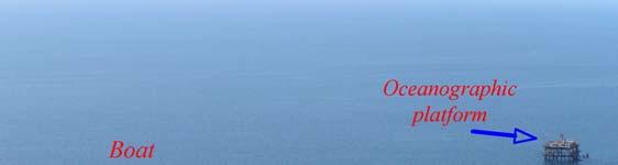
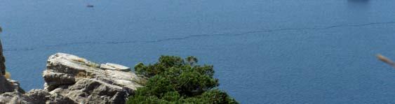
15 Field experiment from an offshore tower in the Black Sea Optical system to measure short wave spectrum and surface mean slope Video system to measure wave breaking characteristics

16 Optical Spectrum Analyzer X-band radar Ka-band radar
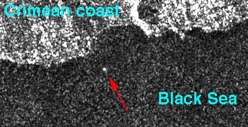
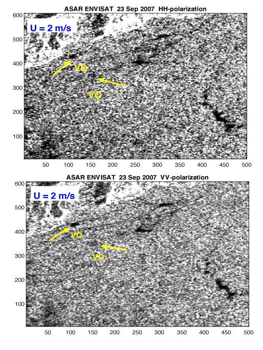
17 Experiments with slick observations from the tower Date, start time : , 16:47 Wind direction No wind 145º (SE) 90º (E) Wind speed Z=4m 0 m/s <0.5 m/s (14:07) 2.5m/s? Wave Vector dir 260º 270º Slick observations VO (13:03) VO (14:15) OLO (15:07) Natural slick (17:12) DF (17:14) Artificial slicks: Veg.Oil, Olive oil, Dodecyl Alcohol, Diesel fuel. Total: , 10: , 15:46 110º No wind 107º (11:43) 90º (12:28) 0 m/s 1-2 m/s 2-3 m/s 1-2 m/s 270º 280º Natural slick (12:00) Natural slick (12:42) Natural slick (12:54) Natural slick (12:59) + VO Natural slick (13:13) OLO (13:43) Natural slick (15:50) Natural slick (16:03) OLO (16:09) Natural slick (16:14) Natural slicks periodic and single bands Total number of slicks: , 10:34 120º 0-2 m/s 300º Natural slick (12:37) , 15:46 150º 1-3 m/s 330º Natural slick (17:17) , 10: , 10:02 0º - 5º 70º 2-4 m/s? 2-4 m/s? 270º 250º VO (12:22) Natural slick (12:30) OLO (12:44) DA (13:00) VO (13:39) VO (15:39) VO (15:50) DA (16:09) OLO (16:23) VO (16:23) OLO (11:55) Periodic Natural slicks ASAR image
18 Contrasts in slicks observed on 05 Oct OSA 10 Radars Photo Contrast Ka-band X-band Contrast OSA Wavenumber, rad/cm Wavenumber, rad/cm Dodecyl alcohol slick (film elasticity E=50-70 mn/m) Vegetable oil slick (film elasticity E=12-15 mn/m) Wind velocity 2-4 m/s
19 SAR observation of experimental oil spills


20 NRCS profile across a slick observed in ASAR APP data Results from SAR analysis of AP images form 2003: The largest slick has a contrast of about 15 db compared to the surrounding clean water
 VV-pol (b) HH-pol (c) Pol ratio (PR) For clean")

21 Another slick observation in SAR APP image Subset of ENVISAT ASAR AP image on 23 August 2003 off Novorossisk coast: (a) VV-pol (b) HH-pol (c) Pol ratio (PR) For clean seas PR is defined by contribution of bragg scattering and wave breaking, with typical value of 5 for this inc angle. In slicks bragg waves disappear and PR becomes close to 1
, resulting in 68")

22 Distribution of oil spills in the Black Sea derived from 68 SAR images SAR images from ERS-2 and ENVISAT were analyzed for a period of three years ( ), resulting in 68 images with 424 likely oil spill events. The distribution of the spills are concentrated along the main shipping lanes and in the offshore drilling area in the western Black Sea
.")

23 Example from the Caspian Sea The ASAR Wideswath image from 04 July 2007 covers most of the Caspian Sea (left figure). A subset of the image (above) was analyzed for the area off Baku (red circle) where a spill event could be detected. The SARTool provided by BOOST Technologies was used to detect and quantify the oil spill area.


24 Oil spill event Kerch Strait 11 November 2007 C-band: RADARSAT X-band: TerraSAR L-band: ALOS PALSAR Courtesy: Scanex Courtesy: DLR Images obtained 16 November - > case study for model comparison

25 Comparison with previous SIR-C/X SAR data and field experiments
26 Oil drift modelling Oil spill input oil spill location oil spill volume and spill rate oil properties fractional composition of the oil Oil spill simulation spreading of the spillets advection evaporation advection turbulent diffusion evaporation emulsification dispersion photo-oxidation bio-oxidation Sea state input currents wind wind waves thermohaline structure bathymetry ice conditions AARI is developing an oil drift model, OilMARS, based on the components shown in the diagram. The model has been tested in the Barents and Kara Seas. Oil spill output Oil slick spatial distribution Oil mass balance

27 Oil spill modelling in Kara Sea: open water AARI uses its oil spill model OilMARS to simulate oil drift in the Kara Sea. The figures show the spreading of a spill over a period of 20 days. The red area indicate where oil reached the coast and caused pollution at the beach.

28 Oil spill modelling in Kara Sea: sea ice waters AARI uses its oil spill model Oilmars to simulate oil drift in the Kara Sea. The figures show the spreading of a spill over a period of 20 days in winter when the sea ice icecovered. Black indicates oil spill in open water, blue indicate oil spill on top of th eice and red is oil spill under the ice.
29 Summary and further work Radar scattering modelling tools is ready for use Field experiments with artificial oil spills at the tower in the Black Sea were performed in 2007, more experiments are planned in 2008 Lab experiments with radar observation of wave damping by various oil types have been conducted Build-up of SAR data base for the study regions have started, primarily with ASAR data. Will be supplemented by other SAR data (X- and L-band) Analysis of SAR data for slick and other ocean surface features, including comparison with models has started Verify hypothesis that PR can be used to identify oil and natural slicks and discriminate them from look-alikes Establish monitoring scheme using satellite data in combination with models and in situ data for validation
30 Acknowledgement The SAR data for the study is provided ESA through AOBE-2780) The research is supported by INTAS (contract no ), EU FP6 (contract no MONRUK), and national projects
MOPED Monitoring of Oil Pollution using Earth Observation Data
 MOPED Monitoring of Oil Pollution using Earth Observation Data ESA/INTAS Project 06-1000025-9091 Earth Sciences and the Environment: Water Quality Contributors Valborg Byfield National Oceanograph Centre,
MONRUK Publishable Final Activity Report
 Project No. 031001 MONRUK Monitoring the marine environment in Russia, Ukraine and Kazakhstan using Synthetic Aperture Radar SPECIFIC TARGETED RESEARCH OR INNOVATION PROJECT SIXTH FRAMEWORK PROGRAMME PRIORITY
Training Course on Radar & Optical RS, IES, Cēsis, Latvia, 5-9 September SAR Marine Applications. Wind and Waves
 SAR Marine Applications Wind and Waves Martin Gade Uni Hamburg, Institut für Meereskunde martin.gade@uni-hamburg.de SAR Marine Applications Friday, 9 Sep, Morning: 1 - History & Basics Introduction Radar/SAR
Arctic Regional Ocean Observing System Arctic ROOS Report from 2012
 Arctic Regional Ocean Observing System Arctic ROOS Report from 2012 By Stein Sandven Nansen Environmental and Remote Sensing Center (www.arctic-roos.org) Focus in 2012 1. Arctic Marine Forecasting Center
Currents and Objects
 SAR Marine Applications Currents and Objects Martin Gade Uni Hamburg, Institut für Meereskunde martin.gade@uni-hamburg.de SAR Maritime Applications Friday, 9 Sep, Morning: 1 - History & Basics Introduction
SAR Training Course, MCST, Kalkara, Malta, November SAR Maritime Applications. Wind and Waves
 SAR Maritime Applications Wind and Waves Martin Gade Uni Hamburg, Institut für Meereskunde SAR Maritime Applications Thursday, 13 Nov.: 1 - History & Basics Introduction Radar/SAR History Basics Scatterometer
MARINE MONITORING OF THE SOUTH- AND EAST CHINA SEAS BASED ON ENVISAT ASAR
 MARINE MONITORING OF THE SOUTH- AND EAST CHINA SEAS BASED ON ENVISAT ASAR Knut-Frode Dagestad (1), Johnny Johannessen (1), Vincent Kerbaol (2), Fabrice Collard (2), Vladimir Kudryavtsev (3, 4), Dmitry
Training Course on Radar & Optical RS, IES, Cēsis, Latvia, 5-9 September SAR Marine Applications. Practicals
 SAR Marine Applications Practicals Martin Gade Uni Hamburg, Institut für Meereskunde martin.gade@uni-hamburg.de SAR Marine Applications Friday, 9 Sep, Morning: 1 - History & Basics Introduction Radar/SAR
Fjernmåling og modellering av oljesøl - på åpen sjø og i is
 Fjernmåling og modellering av oljesøl - på åpen sjø og i is Associate Professor, Camilla Brekke CIRFA (SFI) WP3 leader - Oil Spill Remote Sensing cirfa.uit.no What we are aiming for Detection & characterization
Investigating Coastal Polynya Thin Sea Ice State in the Laptev Sea Using TerraSAR-X Dual-Pol Stripmap Data
 Investigating Coastal Polynya Thin Sea Ice State in the Laptev Sea Using TerraSAR-X Dual-Pol Stripmap Data Thomas Busche (1), Irena Hajnsek (1), Thomas Krumpen (2), Lasse Rabenstein (2), Jens Hoelemann
Utilization of SAR and optical images/data for monitoring of the coastal environment
 Utilization of SAR and optical images/data for monitoring of the coastal environment What is an oil spill? Various petroleum products and their derivatives (petrol, kerosene, gasoline, diesel fuel, fuel,
Monitoring Sea Ice with Space-borne Synthetic Aperture Radar
 Monitoring Sea Ice with Space-borne Synthetic Aperture Radar Torbjørn Eltoft UiT- the Arctic University of Norway CIRFA A Centre for Research-based Innovation cirfa.uit.no Sea ice & climate Some basic
Linking Different Spatial Scales For Retrieval Of Sea Ice Conditions From SAR Images
 Linking Different Spatial Scales For Retrieval Of Sea Ice Conditions From SAR Images Matt Arkett 2, Wolfgang Dierking 1, Jakob Griebel 1, Thomas Hollands 1, Stefanie Linow 1, Eero Rinne 3, Markku Similä
Sharafat GADIMOVA Azerbaijan National Aerospace Agency (ANASA), Azerbaijan
, Azerbaijan") TOWARDS THE DEVELOPMENT OF AN OPERATIONAL STRATEGY FOR OIL SPILL DETECTION AND MONITORING IN THE CASPIAN SEA BASED UPON A TECHNICAL EVALUATION OF SATELLITE SAR OBSERVATIONS IN SOUTHEAST ASIA Sharafat GADIMOVA
TOWARDS THE DEVELOPMENT OF AN OPERATIONAL STRATEGY FOR OIL SPILL DETECTION AND MONITORING IN THE CASPIAN SEA BASED UPON A TECHNICAL EVALUATION OF SATELLITE SAR OBSERVATIONS IN SOUTHEAST ASIA Sharafat GADIMOVA
Remote Sensing for Sea Surface Monitoring. Cristina Bentz PETROBRAS R&D Center Environment Assessment and Monitoring
 Remote Sensing for Sea Surface Monitoring Cristina Bentz PETROBRAS R&D Center Environment Assessment and Monitoring cris@petrobras.com.br Overview Introduction Orbital sea surface monitoring: Scope and
J2.6 SONAR MEASUREMENTS IN THE GULF STREAM FRONT ON THE SOUTHEAST FLORIDA SHELF COORDINATED WITH TERRASAR-X SATELLITE OVERPASSES
 J2.6 SONAR MEASUREMENTS IN THE GULF STREAM FRONT ON THE SOUTHEAST FLORIDA SHELF COORDINATED WITH TERRASAR-X SATELLITE OVERPASSES Chris Maingot 1, Alexander Soloviev 1, Silvia Matt 1, Mikhail Gilman 1,
ICE DRIFT IN THE FRAM STRAIT FROM ENVISAT ASAR DATA
 ICE DRIFT IN THE FRAM STRAIT FROM ENVISAT ASAR DATA Stein Sandven (1), Kjell Kloster (1), and Knut F. Dagestad (1) (1) Nansen Environmental and Remote Sensing Center (NERSC), Thormøhlensgte 47, N-5006
The Wind-Wave Tank of Univ Hamburg
 The Wind-Wave Tank of Univ Hamburg An Overview of Four Decades of Studies of Air-Sea Interactions ГАДЕ, Мартин Хорстович (aka Martin Gade) Institut für Meereskunde, Universität Hamburg, Германия Universität
SAR Data Help Improving the Monitoring of Intertidal Flats on the German North Sea Coast
 SAR Data Help Improving the Monitoring of Intertidal Flats on the German North Sea Coast Martin Gade (1), Kerstin Stelzer (2), and Jörn Kohlus (3) (1) Institut für Meereskunde, Universität Hamburg, Hamburg,
Application of Wavelet Spectrum Analysis to Oil Spill Detection by Using Satellite Observation Data
 PAJ Oil Spill Symposium 2008 Application of Wavelet Spectrum Analysis to Oil Spill Detection by Using Satellite Observation Data February 21, 2008 Tokyo, Japan Masanao Hara Dr., VisionTech Inc. 1. Background
Improved sea-ice monitoring for the Baltic Sea Project summary
 Improved sea-ice monitoring for the Baltic Sea Project summary Leif E.B. Eriksson (1), Karin Borenäs (2), Wolfgang Dierking (3), Anders Berg (1) and Per Pemberton (2) (1) Chalmers University of Technology,
OPERATIONAL SATELLITE MONITORING OF OIL SPILL POLLUTION IN THE SOUTHEASTERN BALTIC SEA: 1.5 YEARS EXPERIENCE
 US/EU-Baltic International Symposium May 23-25, 2006 Klaipeda, Lithuania OPERATIONAL SATELLITE MONITORING OF OIL SPILL POLLUTION IN THE SOUTHEASTERN BALTIC SEA: 1.5 YEARS EXPERIENCE 2006, Andrey G. Kostianoy
The Importance of Microwave Remote Sensing for Operational Sea Ice Services And Challenges
 The Importance of Microwave Remote Sensing for Operational Sea Ice Services And Challenges Wolfgang Dierking January 2015 (1) Why is microwave remote sensing important (=useful) for sea ice mapping? Problems
Indonesian seas Numerical Assessment of the Coastal Environment (IndoNACE) Executive Summary
 Executive Summary") Indonesian seas Numerical Assessment of the Coastal Environment (IndoNACE) Executive Summary Study team members: Dr. Martin Gade, PD Dr. Thomas Pohlmann, Dr. Mutiara Putri Research Centres: Universität
Indonesian seas Numerical Assessment of the Coastal Environment (IndoNACE) Executive Summary Study team members: Dr. Martin Gade, PD Dr. Thomas Pohlmann, Dr. Mutiara Putri Research Centres: Universität
TerraSAR-X and TanDEM-X Applications for Maritime Domain Awereness
 TerraSAR-X and TanDEM-X Applications for Maritime Domain Awereness Dr. Stephan Brusch German Aerospace Center DLR Remote Sensing Technology Institute DLR Oberpfaffenhofen (Germany) Dr. Jürgen Drescher
DLR s TerraSAR-X contributes to international fleet of radar satellites to map the Arctic and Antarctica
 DLR s TerraSAR-X contributes to international fleet of radar satellites to map the Arctic and Antarctica The polar regions play an important role in the Earth system. The snow and ice covered ocean and
The TOPAZ3 forecasting system. L. Bertino, K.A. Lisæter, Mohn-Sverdrup Center/NERSC
 The TOPAZ3 forecasting system L. Bertino, K.A. Lisæter, Mohn-Sverdrup Center/NERSC LOM meeting, Bergen Beach, 20 th Aug. 2007 Introduction Main objective of data assimilation Estimate the most likely
Multisensor monitoring of Peter the Great Bay
 Multisensor monitoring of Peter the Great Bay Leonid Mitnik, Vyacheslav Dubina, Oleg Konstantinov and Vitaly Fischenko V.I. Il'ichev Pacific Oceanological Institute FEB RAS 43 Baltiyskaya St. 690041 Vladivostok,
ANALYSIS OF ASAR POLARISATION SIGNATURES FROM URBAN AREAS (AO-434)
") ANALYSIS OF ASAR POLARISATION SIGNATURES FROM URBAN AREAS (AO-434) Dan Johan Weydahl and Richard Olsen Norwegian Defence Research Establishment (FFI), P.O. Box 25, NO-2027 Kjeller, NORWAY, Email: dan-johan.weydahl@ffi.no
ANALYSIS OF ASAR POLARISATION SIGNATURES FROM URBAN AREAS (AO-434) Dan Johan Weydahl and Richard Olsen Norwegian Defence Research Establishment (FFI), P.O. Box 25, NO-2027 Kjeller, NORWAY, Email: dan-johan.weydahl@ffi.no
Ice surveys, meteorological and oceanographic data What is available and up-to-date?
 Ice surveys, meteorological and oceanographic data What is available and up-to-date? Leader of the Norwegian Ice Service +47 77 62 13 15 - nick.hughes@met.no Norwegian Meteorological Institute met.no 1
CopernicusEU. the EU's Earth Observation Programme. Sara Zennaro Atre Delegation of the European Union to Japan
 Copernicus the EU's Earth Observation Programme Sara Zennaro Atre Delegation of the European Union to Japan Status Overview, Sept 2016 & Ocean Policies Seminar 4 October 2016 ollow us on: Copernicus EU
Iceberg monitoring service by joint use of drift model, SAR and altimeter data
 Iceberg monitoring service by joint use of drift model, SAR and altimeter data N. Longépé, F. Mercier, J.Y Lebras, M. Sutton, G. Hajduch Collecte Localisation Satellites (CLS) SeaSAR, Tromso, June 21,
Experiences with Experimental Spills
 Overview Presentation US Coast Guard Arctic Response Workshop Anchorage April 23, 2010 Experiences with Experimental Spills David Dickins DF Dickins Associates Topics Arctic oil spill R&D history Experimental
1 Introduction. 2 Wind dependent boundary conditions for oil slick detection. 2.1 Some theoretical aspects
 On C-Band SAR Based Oil Slick Detection in the Baltic Sea Markku Similä, István Heiler, Juha Karvonen, and Kimmo Kahma Finnish Institute of Marine Research (FIMR), PB 2, FIN-00561, Helsinki, Finland Email
Validation of sea ice concentration in the myocean Arctic Monitoring and Forecasting Centre 1
 Note No. 12/2010 oceanography, remote sensing Oslo, August 9, 2010 Validation of sea ice concentration in the myocean Arctic Monitoring and Forecasting Centre 1 Arne Melsom 1 This document contains hyperlinks
Routine high resolution observation of selected major surface currents from space
 1 Routine high resolution observation of selected major surface currents from space Fabrice Collard(1), Alexis Mouche(1), Celine Danilo(1), Bertrand Chapron(2), Jordi Isern-Fontanet(2), Johnny Johannessen(3)
Mud Volcanoes in the South Caspian Basin: Activity Inferred From ENVISAT ASAR Images
 Mud Volcanoes in the South Caspian Basin: Activity Inferred From ENVISAT ASAR Images Martin Weinelt & Warner Brückmann Helmholtz Centre for Ocean Research Kiel 1 Mud Volcanoes in the South Caspian Basin
Space for the Arctic
 Space for the Arctic Bo Andersen Norwegian Polar Committee & Norwegian Space Centre 1 My Mantra for Space Few, if any of the global challenges can be resolved by space alone But Few, if any can be resolved
OIL POLLUTION IN THE SOUTHEASTERN BALTIC SEA IN
 Transport and Telecommunication, 2014, volume 15, no. 4, 285-294 Transport and Telecommunication Institute, Lomonosova 1, Riga, LV-1019, Latvia OIL POLLUTION IN THE SOUTHEASTERN BALTIC SEA IN 2009-2011
Developing integrated remote sensing and GIS procedures for oil spill monitoring on the Libyan coast
 Coastal Processes III 125 Developing integrated remote sensing and GIS procedures for oil spill monitoring on the Libyan coast A. Eljabri & C. Gallagher Department of Civil Engineering and Built Environment,
PREDICTION OF OIL SPILL TRAJECTORY WITH THE MMD-JMA OIL SPILL MODEL
 PREDICTION OF OIL SPILL TRAJECTORY WITH THE MMD-JMA OIL SPILL MODEL Project Background Information MUHAMMAD HELMI ABDULLAH MALAYSIAN METEOROLOGICAL DEPARTMENT(MMD) MINISTRY OF SCIENCE, TECHNOLOGY AND INNOVATION
Making a case for full-polarimetric radar remote sensing
 Making a case for full-polarimetric radar remote sensing Jeremy Nicoll Alaska Satellite Facility, University of Alaska Fairbanks 1 Polarization States of a Coherent Plane Wave electric field vector vertically
STUDIES OF OCEAN S SCATTERING PROPERTIES BASED ON AIRSAR DATA
 STUDIES OF OCEAN S SCATTERING PROPERTIES BASED ON AIRSAR DATA Wang Wenguang *, Sun Jinping, Wang Jun, Hu Rui School of EIE, Beihang University, Beijing 00083, China- wwenguang@ee.buaa.edu.cn KEY WORDS:
COMPLEX MONITORING OF OIL POLLUTION IN THE BALTIC, BLACK AND CASPIAN SEAS
 COMPLEX MONITORING OF OIL POLLUTION IN THE BALTIC, BLACK AND CASPIAN SEAS Kostianoy A.G. (1), Lavrova O.Yu. (2), Mityagina M.I. (2), Bocharova T.Yu. (2), Litovchenko K.Ts. (3), Lebedev S.A. (4, 5), Stanichny
OCEAN SURFACE DRIFT BY WAVELET TRACKING USING ERS-2 AND ENVISAT SAR IMAGES
 OCEAN SURFACE DRIFT BY WAVELET TRACKING USING ERS-2 AND ENVISAT SAR IMAGES Antony K. Liu, Yunhe Zhao Ocean Sciences Branch, NASA Goddard Space Flight Center, Greenbelt, Maryland, USA Ming-Kuang Hsu Northern
TOWARDS A TRACKING OF SMALL SCALE EDDIES USING HIGH- RESOLUTION RADARSAT-2 AND TERRASAR-X IMAGERY
 1 st EARSeL Workshop on Temporal Analysis of Satellite Images 1 TOWARDS A TRACKING OF SMALL SCALE EDDIES USING HIGH- RESOLUTION RADARSAT-2 AND TERRASAR-X IMAGERY Benjamin Seppke 1, Prof. Dr. Leonie Dreschler-Fischer
INTAROS Integration of the existing Arctic observing systems into a common data frame. Roberta Pirazzini, Finnish Meteorological Institute
 INTAROS Integration of the existing Arctic observing systems into a common data frame Roberta Pirazzini, Finnish Meteorological Institute Outline 1. Overview of the INTAROS project 2. Overview of the INTAROS
Platform measurements of Ka-band sea surface radar Doppler characteristics. Yu. Yu. Yurovsky, Semyon Grodsky (UMD), V. N. Kudryavtsev, and B.
, V. N. Kudryavtsev, and B.") Platform measurements of Ka-band sea surface radar Doppler characteristics Yu. Yu. Yurovsky, Semyon Grodsky (UMD), V. N. Kudryavtsev, and B. Chapron With support from NASA/PhO, IOWVST 2017 Outline Instrument
Platform measurements of Ka-band sea surface radar Doppler characteristics Yu. Yu. Yurovsky, Semyon Grodsky (UMD), V. N. Kudryavtsev, and B. Chapron With support from NASA/PhO, IOWVST 2017 Outline Instrument
Integrated Space Applications in Transport, Energy & Safety Oil & Gas Exploration
 Exploration & Production Technology delivering breakthrough solutions Integrated Space Applications in Transport, Energy & Safety Oil & Gas Exploration Dr Colin Grant Engineering Technical Authority, Metocean
Arctic Observing Systems Challenges, New opportunities and Integration
 Arctic Observing Systems Challenges, New opportunities and Integration Japan Norway Arctic Science Week 03 June 2016 By Stein Sandven, NERSC Building an integrated Arctic Observing System Need to collect,
Operational ice charting in mid-latitudes using Near-Real-Time SAR imagery
 Operational ice charting in mid-latitudes using Near-Real-Time SAR imagery Sergey Vernyayev Ice Engineer ICEMAN.KZ Carles Debart Project Manager Energy, Environment and Security Yevgeniy Kadranov Ice charting
RADAR PHOTO SMOOTH OCEAN LONG WAVES. Introduction
 Formation of radar and visible contrasts from the water surface RADAR PHOTO SMOOTH OCEAN SHORT WAVES Beal, 1994 LONG WAVES INTERNAL WAVES Introduction Satellite RAR and SAR have a high potential to study
Low-Backscatter Ocean Features in Synthetic Aperture Radar Imagery
 P. CLEMENTE-COLÓN AND X-H. YAN Low-Backscatter Ocean Features in Synthetic Aperture Radar Imagery Pablo Clemente-Colón and Xiao-Hai Yan Many ocean surface signatures in synthetic aperture radar (SAR) imagery
EXPLOITING SUNGLINT SIGNATURES FROM MERIS AND MODIS IMAGERY IN COMBINATION TO SAR DATA TO DETECT OIL SLICKS
 EXPLOITING SUNGLINT SIGNATURES FROM MERIS AND MODIS IMAGERY IN COMBINATION TO SAR DATA TO DETECT OIL SLICKS M. Adamo 1, G. De Carolis 2, V. De Pasquale 2, and G. Pasquariello 2 1 Dept. of Physics, University
OPTIMIZATION IN OIL SLICK COMBATING STATIONS ALLOCATION. APPLICATION TO THE SEA OF AZOV
 Global NEST Journal, Vol 16, No 2, pp 402-410, 2014 Copyright 2014 Global NEST Printed in Greece. All rights reserved OPTIMIZATION IN OIL SLICK COMBATING STATIONS ALLOCATION. APPLICATION TO THE SEA OF
EO-Based Ice and Iceberg Monitoring in Support of Offshore Engineering Design and Tactical Operations
 EO-Based Ice and Iceberg Monitoring in Support of Offshore Engineering Design and Tactical Operations Desmond Power, C-CORE ESA Industry Workshop on Satellite EO for the Oil and Gas Sector Overview Operations
Shashi Kumar. Indian Institute of Remote Sensing. (Indian Space Research Organisation)
") Practical-1 SAR Image Interpretation Shashi Kumar Indian Institute of Remote Sensing (Indian Space Research Organisation) Department of Space, Government of India 04 Kalidas Road, Dehradun - 248 001, U.K.
Practical-1 SAR Image Interpretation Shashi Kumar Indian Institute of Remote Sensing (Indian Space Research Organisation) Department of Space, Government of India 04 Kalidas Road, Dehradun - 248 001, U.K.
MESOSCALE VARIABILITIES IN SEA SURFACE CURRENT FIELDS DERIVED THROUGH MULTI-SENSOR TRACKING OF SEA SURFACE FILMS
 MESOSCALE VARIABILITIES IN SEA SURFACE CURRENT FIELDS DERIVED THROUGH MULTI-SENSOR TRACKING OF SEA SURFACE FILMS Benjamin Seppke (1), Martin Gade (2), Leonie Dreschler-Fischer (2) (1) University of Hamburg,
GEOSC/METEO 597K Kevin Bowley Kaitlin Walsh
 GEOSC/METEO 597K Kevin Bowley Kaitlin Walsh Timeline of Satellites ERS-1 (1991-2000) NSCAT (1996) Envisat (2002) RADARSAT (2007) Seasat (1978) TOPEX/Poseidon (1992-2005) QuikSCAT (1999) Jason-2 (2008)
Coastal Ocean Applications Demonstrations of ALOS PALSAR Imagery for NOAA CoastWatch
 Coastal Ocean Applications Demonstrations of ALOS PALSAR Imagery for NOAA CoastWatch William Pichel Center for Satellite Applications and Research Frank Monaldo The Johns Hopkins University Applied Physics
Marine Situational Awareness and Environmental Monitoring using Satellites
 1 The Ny-ålesund Symposium 2013 The Changing Arctic Opportunity or Threat Marine Situational Awareness and Environmental Monitoring using Satellites Rolf Skatteboe President, Kongsberg Satellite Services
C-BAND MULTIPLE POLARIZATION SAR FOR ICE MONITORING WHAT CAN IT DO FOR THE CANADIAN ICE SERVICE
 C-BAND MULTIPLE POLARIZATION SAR FOR ICE MONITORING WHAT CAN IT DO FOR THE CANADIAN ICE SERVICE Matt Arkett, Dean Flett, and Roger De Abreu Canadian Ice Service, Meteorological Service of Canada, Environment
5. TRACKING AND SURVEILLANCE
 5. Knowledge of the present position of spilled oil and an ability to predict its motion are essential components of any oil spill response. This function is known as surveillance and tracking and has
SYNERGY OF MERIS/ASAR FOR OBSERVING MARINE FILM SLICKS AND SMALL SCALE PROCESSES.
 SYNERGY OF MERIS/ASAR FOR OBSERVING MARINE FILM SLICKS AND SMALL SCALE PROCESSES. J.C.B. da Silva (1), S. Correia (1), S.A. Ermakov (), I. A. Sergievskaya () and I.S. Robinson (3) (1) Department of Physics
Challenges for SAR operations in the Barents Sea. Tor Einar Berg, Beate Kvamstad
 Challenges for SAR operations in the Barents Sea Tor Einar Berg, Beate Kvamstad MARINTEK, Trondheim, Norway, Tor.E.Berg@marintek.sintef.no This paper gives a brief overview of challenges in SAR operations
Opportunities for advanced Remote Sensing; an outsider s perspective
 Opportunities for advanced Remote Sensing; an outsider s perspective Ramon Hanssen Delft University of Technology 1 Starting questions Can we do more with the data we are already acquire? What s in stock
SAR data Sensords and examples
 SAR data Sensords and examples Sar Technical Training for Forest Mapping 2014/2015 Cédric Lardeux Jean-Paul Rudant Pierre-Louis Frison cedric.lardeux@onfinternational.com rudant@univ-mlv.fr frison@univ-mlv.fr
Sea Ice Monitoring in the European Arctic Seas Using a Multi-Sensor Approach
 Sea Ice Monitoring in the European Arctic Seas Using a Multi-Sensor Approach Stein Sandven Nansen Environmental and Remote Sensing Center, Bergen, Norway Abstract. Advances in satellite remote sensing
Numerical Simulation of the Wind Stress Effect on ALOS PALSAR Images of Far Wakes of Ships Atsushi Fujimura and Alexander Soloviev
 Numerical Simulation of the Wind Stress Effect on ALOS PALSAR Images of Far Wakes of Ships Atsushi Fujimura and Alexander Soloviev Nova Southeastern University Oceanographic Center Dania Beach, Florida,
Infrastructure monitoring using SAR interferometry
 Infrastructure monitoring using SAR interferometry Hossein Nahavandchi Roghayeh Shamshiri Norwegian University of Science and Technology (NTNU), Department of Civil and Environmental Engineering Geodesy
Mersea Oil Spill Drift Forecast Demonstrations in TOP2
 Mersea Oil Spill Drift Forecast Demonstrations in TOP2 Bruce Hackett (met.no), George Zodiatis (UCY), Pierre Daniel (MeteoFrance), Francois Parthiot (Cedre) Presented at 3rd Mersea Plenary Meeting, CNR,
ASAR practical training session
 ASAR practical training session Dr. Fabrice Collard and Dr. Vincent Kerbaol, BOOST Technologies, Brest, France Prof. Johnny Johannessen NERSC, Bergen, Norway 2 Presentation of the company The activities
K&C Phase 4 Status report. Ice Sheet Monitoring using ALOS-2. University of California, Irvine 2 JPL
 K&C Phase 4 Status report Ice Sheet Monitoring using ALOS-2 Bernd Scheuchl 1, Jeremie Mouginot 1, Eric Rignot 1,2 1 University of California, Irvine 2 JPL Science Team meeting #24 Tokyo, Japan, January
Wave Propagation Model for Coherent Scattering from a Randomly Distributed Target
 Wave Propagation Model for Coherent Scattering from a Randomly Distributed Target Don Atwood,Ben Matthiss, Liza Jenkins, Shimon Wdowinski, Sang Hoon Hong, and Batuhan Osmanoglu Outline Requirements for
TOSCA RESULTS OVERVIEW
 TOSCA RESULTS OVERVIEW Almost 3 years after the project started, TOSCA has proved capable of improving oil spill tracking systems. TOSCA has brought updated knowledge on surface currents and noticeable
SAR Raw Signal Simulation of Oil Slicks in Ocean Environments
 IEEE TRANSACTIONS ON GEOSCIENCE AND REMOTE SENSING, VOL. 40, NO. 9, SEPTEMBER 2002 1935 SAR Raw Signal Simulation of Oil Slicks in Ocean Environments Giorgio Franceschetti, Life Fellow, IEEE, Antonio Iodice,
SAWS: Met-Ocean Data & Infrastructure in Support of Industry, Research & Public Good. South Africa-Norway Science Week, 2016
 SAWS: Met-Ocean Data & Infrastructure in Support of Industry, Research & Public Good South Africa-Norway Science Week, 2016 Marc de Vos, November 2016 South Africa: Context http://learn.mindset.co.za/sites/default/files/resourcelib/e
GEOGG141 Principles & Practice of Remote Sensing (PPRS) RADAR III: Applications Revision
 RADAR III: Applications Revision") UCL DEPARTMENT OF GEOGRAPHY GEOGG141 Principles & Practice of Remote Sensing (PPRS) RADAR III: Applications Revision Dr. Mathias (Mat) Disney UCL Geography Office: 113, Pearson Building Tel: 7670 0592
UCL DEPARTMENT OF GEOGRAPHY GEOGG141 Principles & Practice of Remote Sensing (PPRS) RADAR III: Applications Revision Dr. Mathias (Mat) Disney UCL Geography Office: 113, Pearson Building Tel: 7670 0592
British Colombia Knight Inlet Strait of Georgia Strait of Juan de Fuca
 An Atlas of Oceanic Internal Solitary Waves (February 2004) Knight Inlet Strait of Georgia Strait of Juan de Fuca Overview Knight Inlet, the Strait of Georgia and the Strait of Juan de Fuca are all shallow
1. Regarding the availability of two co-polarized (HH and VV) channels.
 channels.") Dear Anonymous Referee #2, Thank you for your insightful and stimulating review comments. Modifications based on these comments will significantly improve the quality of this research paper. General Comments:
Dear Anonymous Referee #2, Thank you for your insightful and stimulating review comments. Modifications based on these comments will significantly improve the quality of this research paper. General Comments:
PETROLEUM HAZARDS MANAGEMENT BY GEOMATIC SYSTEMS
 PETROLEUM HAZARDS MANAGEMENT BY GEOMATIC SYSTEMS H. ASSILZADEH Spatial Information Technology & Engineering (SITE) Research Center Faculty of Engineering, Universiti Putra Malaysia, 43400 UPM, Serdang
The 3 rd NOWPAP Joint Training Courses on Remote Sensing Data Analysis. Vladivostok, Russia, 11 October 2011
 The 3 rd NOWPAP Joint Training Courses on Remote Sensing Data Analysis Vladivostok, Russia, 11 October 2011 Monitoring of oil pollution with the use of satellite imagery Leonid M. Mitnik V.I. Il'ichev
MARINE AND MARITIME SAR APPLICATIONS: COSMO-SKYMED FROM 1 ST TO 2 ND GENERATION
 MARINE AND MARITIME SAR APPLICATIONS: COSMO-SKYMED FROM 1 ST TO 2 ND GENERATION Maurizio Migliaccio, Ferdinando Nunziata, Andrea Buono Dipartimento di Ingegneria, Università degli Studi di Napoli Parthenope
ABSTRACT 1. INTRODUCTION
 Multi-Sensor Satellite Survey of the Surface Oil Pollution in the Caspian Sea Marina I. Mityagina and Olga Yu. Lavrova Space Research Institute, Russian Academy of Sciences, 117997, Moscow, Russia, Profsoyuznaya
EONav Satellite data in support of maritime route optimization
 EONav Satellite data in support of maritime route optimization Leif Eriksson Department of Space, Earth and Environment Chalmers University of Technology Outline Why is maritime navigation support needed?
DUAL-POLARIZED COSMO SKYMED SAR DATA TO OBSERVE METALLIC TARGETS AT SEA
 DUAL-POLARIZED COSMO SKYMED SAR DATA TO OBSERVE METALLIC TARGETS AT SEA F. Nunziata, M. Montuori and M. Migliaccio Università degli Studi di Napoli Parthenope Dipartimento per le Tecnologie Centro Direzionale,
Detection, tracking and study of polar lows from satellites Leonid P. Bobylev
 Detection, tracking and study of polar lows from satellites Leonid P. Bobylev Nansen Centre, St. Petersburg, Russia Nansen Centre, Bergen, Norway Polar lows and their general characteristics International
Snow property extraction based on polarimetry and differential SAR interferometry
 Snow property extraction based on polarimetry and differential SAR interferometry S. Leinß, I. Hajnsek Earth Observation and Remote Sensing, Institute of Enviromental Science, ETH Zürich TerraSAR X and
Sentinel-1 Mission Status
 Sentinel-1 Mission Status Pierre Potin, Sentinel-1 Mission Manager, ESA Luca Martino, Technical Support Engineer, ESA... and the Sentinel-1 operations team PSTG SAR Coordination Working Group 14 December
Floating Ice: Progress in Addressing Science Goals
 Polar Floating Ice: Progress in Addressing Science Goals Stephen Howell 1, Leif Toudal Pedersen 2 and Roberto Saldo 3 1 Environment Canada, Climate Research Division, Toronto, Canada 2 Danish Meteorological
Microwave Remote Sensing of Soil Moisture. Y.S. Rao CSRE, IIT, Bombay
 Microwave Remote Sensing of Soil Moisture Y.S. Rao CSRE, IIT, Bombay Soil Moisture (SM) Agriculture Hydrology Meteorology Measurement Techniques Survey of methods for soil moisture determination, Water
Annex VI-1. Draft National Report on Ocean Remote Sensing in China. (Reviewed by the Second Meeting of NOWPAP WG4)
") UNEP/NOWPAP/CEARAC/WG4 2/9 Page1 Draft National Report on Ocean Remote Sensing in China (Reviewed by the Second Meeting of NOWPAP WG4) UNEP/NOWPAP/CEARAC/WG4 2/9 Page1 1. Status of RS utilization in marine
UNEP/NOWPAP/CEARAC/WG4 2/9 Page1 Draft National Report on Ocean Remote Sensing in China (Reviewed by the Second Meeting of NOWPAP WG4) UNEP/NOWPAP/CEARAC/WG4 2/9 Page1 1. Status of RS utilization in marine
Air-sea Gas Exchange and Bio-surfactants: Low and High Wind Speed Extremes
 Air-sea Gas Exchange and Bio-surfactants: Low and High Wind Speed Extremes A. Soloviev in collaboration with M. McGauley, S. Matt, M.Shivji, A. Tartar, N. Kurata, K. Vella, W. Perrie B. Haus, D. Ortiz-Suslow,
On the Shape of the Fast Ice Drift Ice Contact Zone
 Geophysica (004), 40(1-), 3-13 On the Shape of the Fast Ice Drift Ice Contact Zone Robert V. Goldstein 1, Nikolai N. Osipenko 1 and Matti Leppäranta 1 Institute of Problems in Mechanics, Russian Academy
Seatrack Web Developments
 Seatrack Web Seatrack Web Developments HELCOM RESPONSE 16/2012, 21 November 2012 Johan Mattsson, DCOO Seatrack Web Contents Short overview Recent developments Online demonstration (experimental) Questions
On radar imaging of current features: 2. Mesoscale eddy and current front detection
 JOURNAL OF GEOPHYSICAL RESEARCH, VOL. 110,, doi:10.1029/2004jc002802, 2005 On radar imaging of current features: 2. Mesoscale eddy and current front detection J. A. Johannessen, 1,2 V. Kudryavtsev, 3,4
Ice Analyst Workshop Case Study Routine Monitoring Of Ice Islands. WMO IAW-2 Tromso Norway Laurie Weir CIS Vladimir Bessonov AARI June
 Ice Analyst Workshop Case Study Routine Monitoring Of Ice Islands WMO IAW-2 Tromso Norway Laurie Weir CIS Vladimir Bessonov AARI June 15-19 2009 Outline Ice Shelves to Ice Islands Resources & tools for
Amina Rangoonwala and Elijah Ramsey III Wetland and Aquatic Research Center. U.S. Geological Survey. Lafayette, LA
 First I will show examples of radar mapping of hurricane surge extent and duration and optical mapping of the resultant marsh dieback along the Louisiana coast Next we extend these works to hurricane Sandy
The Polar Ice Sheets Monitoring Project A Coordinated Response from Space Agencies
 The Polar Ice Sheets Monitoring Project A Coordinated Response from Space Agencies Yves Crevier / Members of the PSTG SAR Coordination WG Canadian Space Agency CEOS SIT-28 Meeting Hampton, Virginia, USA
Studies of Austfonna ice cap (Svalbard) using radar altimetry with other satellite techniques
 using radar altimetry with other satellite techniques") 15 Years of progress in Radar Altimetry Symposium Ocean surface topography science team (OSTST) International Doris Service (IDS) Workshop, Argo Workshop 13-18 March 2006, Venice, Italy Alexei V. Kouraev,
15 Years of progress in Radar Altimetry Symposium Ocean surface topography science team (OSTST) International Doris Service (IDS) Workshop, Argo Workshop 13-18 March 2006, Venice, Italy Alexei V. Kouraev,