Ice Analyst Workshop Case Study Routine Monitoring Of Ice Islands. WMO IAW-2 Tromso Norway Laurie Weir CIS Vladimir Bessonov AARI June
|
|
|
- Willis Cobb
- 5 years ago
- Views:
Transcription
1 Ice Analyst Workshop Case Study Routine Monitoring Of Ice Islands WMO IAW-2 Tromso Norway Laurie Weir CIS Vladimir Bessonov AARI June
2 Outline Ice Shelves to Ice Islands Resources & tools for analysis Partnerships in tracking Imagery Review

3 Ice Shelf Genesis Ice shelves found in the Canadian High arctic are created by very different processes than their Antarctic counterparts. The Canadian ice shelves are created by accumulations of snow and basal accretion on multiyear land-fast ice occurring over a long period of time, while the Antarctic and southern Greenlandic is shelves are created by glacial systems located on land extending over the ocean. This has sometimes led to the former being termed ice shelves and the latter being termed glacial ice tongues. (Dowdeswell et al 1994, Jeffries 1987) Ward Hunt Ice Shelf Ayles Ice Shelf Milne Ice Shelf Petersen Ice Shelf Serson Ice Shelf Wesley Van Wychen CIS CO-OP OP 2007
4 Whats going on? Ice Shelves are Calving as a result of a combination of: Long-term temperature increases leads to Long-term reduction in ice shelf thickness; Dramatic reductions in arctic sea ice leads to more Open water at the shelf face for extended periods in summer 2005 & 2008 saw record warm temperatures High winds (Dr Luke Copland University of Ottawa)

5 Ice Island Calving Mechanisms With warmer temperatures weakening the ice structure here are some scenarios: Scenario 1: Persistent winds, tidal action and pressure from the surrounding ice pack may cause cracks to develop within ice shelf: thus producing and ice island. (Holdsworth 1971, Jeffries 1985) Winds Tidal Action Ice Pack Pressure Wesley Van Wychen CIS CO-OP OP 2007
6 Ice Island Calving Mechanisms Scenario 2: Vibrations due to wave action cause a resonance that causes stresses in the ice shelf to the point where a fracture can occur. (Holdsworth & Glynn 1978) Ice Island Ice Shelf Wave Action Causing Resonance on Ice Shelf Fracture Wesley Van Wychen CIS CO-OP OP 2007
7 Ice Island Calving Mechanisms Scenario 3: Strong tides associated with storm surges occur, creating a period of time of intense pressure against the ice shelf, which causes the shelf to crack. The prevailing winds then change, creating open water and areas where the newly calved ice island can flow into. (Sackinger 1987) Storm Surge Wind Wesley Van Wychen CIS CO-OP OP 2007

8 Dr. Luke Copland University of Ottawa
9 Fracture History and Tracking Ayles Ice Shelf Fractured August 2005 Largest calving event in the last 40+ years Produced an ice island 66 km sq. 45m thick 2007 Sept Ayles fractures into 2 ice islands 2008 Ward Hunt lost 42 km all of Markham ice island 2008 Serson lost 60% of its area losing 122 km July Petermann Ice Island calves - NW Greenland-25 km Petersen Ice Shelf has lost ~1/3 its area in last 3 years (Copland) 2009 June Ayles 2 nd ice island, now seen in multiple fragments in McDougall Snd/Penny Strait

10 Ice Shelves to Ice Islands Modis

11 Shelves Left

12 Remaining Shelves Ward Hunt Milne Petersen-partial Serson 24 May 2009 RADARSAT MDA LTD All Rights Reserved

13 Markham Ice Island Ayles Ice islands Petermann Ice Island June RADARSAT-2 Data and Products MacDONALD, DETTWILER AND ASSOCIATES LTD. (2009)


14 Tracking with Beacons Ayles & Serson s, Petermann
 From Jan 25/09 RADARSAT-2 image: Size ~15 km 2 (down from 21 km 2 ) Estimated Mass 750,000,000 tons (Assuming a 55m")
15 Petermann Ice Island RADARSAT-2 Data and Products MacDONALD, DETTWILER AND ASSOCIATES LTD. (2009) From Jan 25/09 RADARSAT-2 image: Size ~15 km 2 (down from 21 km 2 ) Estimated Mass 750,000,000 tons (Assuming a 55m thickness) Drift speed (Dec-Feb) ~ 9 nm/day


16 Extreme Ice Features May 18 Ongoing Focus Ice Islands CANATEC R2 HH+HV+VV+VH ALOS PALSAR In situ obs Met. data


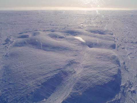
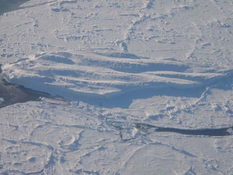
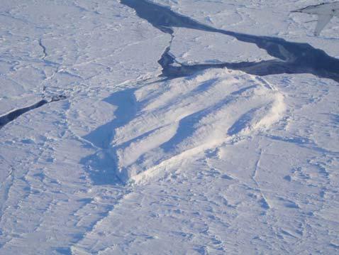
17 Photos Dr Derek Mueller and Dr Luke Copland


18 Tracking: With High Resolution Imagery Isn t Always Possible RADARSAT-1 09 MARCH / MARS 2007 RADARSAT-2 14 MARCH / MARS M Resolution

19 Need A Multi Sensor Approach It s not always black and white ESA Envisat ASAR June Landsat 06 June 09

20 Landsat June 06 and RSAT2-June z Landsat 06 June 09 RADARSAT-2 Data and Products MacDONALD, DETTWILER AND ASSOCIATES LTD. (2009)


21 Calculating Drift of Ayles Fragments Landsat June RSAT2 June June June 15th RADARSAT-2 Data and Products MacDONALD, DETTWILER AND ASSOCIATES LTD. (2009)
22 Acknowledgements Workshops such as this illustrate that frequently, we are all monitoring the same ice regime and can improve and learn from each others experience RADARSAT-2 Data MacDonald, Dettwiler and Associates Ltd. (2009) - All Rights Reserved. Données et produits de RADARSAT-2 MacDonald, Dettwiler and Associates Ltd. (2009) tous droits réservés. MODIS NASA Envisat images ESA Content- Luke Copland, Derek Mueller, Luc Desjardins, Roger DeAbreu

23 Thanks for your attention Questions?
Glaciology Exchange (Glacio-Ex) Norwegian/Canadian/US Partnership Program
 Norwegian/Canadian/US Partnership Program") Glaciology Exchange (Glacio-Ex) Norwegian/Canadian/US Partnership Program Luke Copland University of Ottawa, Canada Jon Ove Hagen University of Oslo, Norway Kronebreeen, Svalbard. Photo: Monica Sund The
Glaciology Exchange (Glacio-Ex) Norwegian/Canadian/US Partnership Program Luke Copland University of Ottawa, Canada Jon Ove Hagen University of Oslo, Norway Kronebreeen, Svalbard. Photo: Monica Sund The
Rapid loss of the Ayles Ice Shelf, Ellesmere Island, Canada
 Click Here for Full Article GEOPHYSICAL RESEARCH LETTERS, VOL. 34, L21501, doi:10.1029/2007gl031809, 2007 Rapid loss of the Ayles Ice Shelf, Ellesmere Island, Canada Luke Copland, 1 Derek R. Mueller, 2
Glaciers, Ice Shelves and Ice Islands
 Glaciers, Ice Shelves and Ice Islands Lead authors Luke Copland 1, Adrienne White 1, Anna Crawford 2 Contributing authors Derek R. Mueller 2, Wesley Van Wychen 1, Laura Thomson 3, Warwick F. Vincent 4
Canadian Ice Service
 Canadian Ice Service Key Points and Details concerning the 2009 Arctic Minimum Summer Sea Ice Extent October 1 st, 2009 http://ice-glaces.ec.gc.ca 1 Key Points of Interest Arctic-wide The Arctic-wide minimum
Linking Different Spatial Scales For Retrieval Of Sea Ice Conditions From SAR Images
 Linking Different Spatial Scales For Retrieval Of Sea Ice Conditions From SAR Images Matt Arkett 2, Wolfgang Dierking 1, Jakob Griebel 1, Thomas Hollands 1, Stefanie Linow 1, Eero Rinne 3, Markku Similä
Today s Lecture: Land, biosphere, cryosphere (All that stuff we don t have equations for... )
") Today s Lecture: Land, biosphere, cryosphere (All that stuff we don t have equations for... ) 4 Land, biosphere, cryosphere 1. Introduction 2. Atmosphere 3. Ocean 4. Land, biosphere, cryosphere 4.1 Land
Today s Lecture: Land, biosphere, cryosphere (All that stuff we don t have equations for... ) 4 Land, biosphere, cryosphere 1. Introduction 2. Atmosphere 3. Ocean 4. Land, biosphere, cryosphere 4.1 Land
Polar Portal Season Report 2013
 Polar Portal Season Report 2013 All in all, 2013 has been a year with large melting from both the Greenland Ice Sheet and the Arctic sea ice but not nearly as large as the record-setting year of 2012.
Sea Ice Motion: Physics and Observations Ron Kwok Jet Propulsion Laboratory California Institute of Technology, Pasadena, CA
 Sea Ice Motion: Physics and Observations Ron Kwok Jet Propulsion Laboratory California Institute of Technology, Pasadena, CA 7 th ESA Earth Observation Summer School ESRIN, Frascati, Italy 4-14 August
The Importance of Microwave Remote Sensing for Operational Sea Ice Services And Challenges
 The Importance of Microwave Remote Sensing for Operational Sea Ice Services And Challenges Wolfgang Dierking January 2015 (1) Why is microwave remote sensing important (=useful) for sea ice mapping? Problems
K&C Phase 4 Status report. Ice Sheet Monitoring using ALOS-2. University of California, Irvine 2 JPL
 K&C Phase 4 Status report Ice Sheet Monitoring using ALOS-2 Bernd Scheuchl 1, Jeremie Mouginot 1, Eric Rignot 1,2 1 University of California, Irvine 2 JPL Science Team meeting #24 Tokyo, Japan, January
Monitoring Sea Ice with Space-borne Synthetic Aperture Radar
 Monitoring Sea Ice with Space-borne Synthetic Aperture Radar Torbjørn Eltoft UiT- the Arctic University of Norway CIRFA A Centre for Research-based Innovation cirfa.uit.no Sea ice & climate Some basic
VIDEO/LASER HELICOPTER SENSOR TO COLLECT PACK ICE PROPERTIES FOR VALIDATION OF RADARSAT SAR BACKSCATTER VALUES
 VIDEO/LASER HELICOPTER SENSOR TO COLLECT PACK ICE PROPERTIES FOR VALIDATION OF RADARSAT SAR BACKSCATTER VALUES S.J. Prinsenberg 1, I.K. Peterson 1 and L. Lalumiere 2 1 Bedford Institute of Oceanography,
Freeze-Up Studies of the Alaskan Beaufort and Chukchi Seas: through Coastal Frontiers Corporation Vaudrey & Associates, Inc.
 Freeze-Up Studies of the Alaskan Beaufort and Chukchi Seas: 2009-10 through 2015-16 Coastal Frontiers Corporation Vaudrey & Associates, Inc. Joint-Industry Sponsors U.S. Department of the Interior Bureau
Changing Marine Access in the Arctic Ocean: The Arctic Climate Impact Assessment Panama Canal Authority 11 January 2005
 Changing Marine Access in the Arctic Ocean: The Arctic Climate Impact Assessment Panama Canal Authority 11 January 2005 Lawson Brigham Deputy Director, U.S. Arctic Research Commission ACIA Contributing
An Overview. Jeff Key (NOAA) PSTG Vice-Chair. on behalf of Polar Space Task Group. Polar Space Task Group
 PSTG Vice-Chair. on behalf of Polar Space Task Group. Polar Space Task Group") An Overview Jeff Key (NOAA) PSTG Vice-Chair on behalf of Asia CryoNet Meeting 4 December 2013, Beijing Cryosphere Satellite Missions International Year (IPY) The IPY provided an international framework
An Overview Jeff Key (NOAA) PSTG Vice-Chair on behalf of Asia CryoNet Meeting 4 December 2013, Beijing Cryosphere Satellite Missions International Year (IPY) The IPY provided an international framework
ATOC OUR CHANGING ENVIRONMENT Class 19 (Chp 6) Objectives of Today s Class: The Cryosphere [1] Components, time scales; [2] Seasonal snow
![ATOC OUR CHANGING ENVIRONMENT Class 19 (Chp 6) Objectives of Today s Class: The Cryosphere [1] Components, time scales; [2] Seasonal snow](/thumbs/95/126309683.jpg "ATOC OUR CHANGING ENVIRONMENT Class 19 (Chp 6) Objectives of Today s Class: The Cryosphere [1] Components, time scales; [2] Seasonal snow") ATOC 1060-002 OUR CHANGING ENVIRONMENT Class 19 (Chp 6) Objectives of Today s Class: The Cryosphere [1] Components, time scales; [2] Seasonal snow cover, permafrost, river and lake ice, ; [3]Glaciers and
ATOC 1060-002 OUR CHANGING ENVIRONMENT Class 19 (Chp 6) Objectives of Today s Class: The Cryosphere [1] Components, time scales; [2] Seasonal snow cover, permafrost, river and lake ice, ; [3]Glaciers and
Southern Ocean observations & change
 Southern Ocean observations & change Steve Rintoul Project leader CSHOR Project staff Steve Rintoul (Project leader and research scientist) Laura Herraiz-Borreguero (Research scientist) Alessandro Silvano
Canadian Space Agency Update. STG 3 ESRIN, Frascati May 5-6, 2008 Yves Crevier
 Canadian Space Agency Update STG 3 ESRIN, Frascati May 5-6, 2008 Yves Crevier Role of CSA in IPY Ensure the use of Space Technologies in IPY Science initiatives Guarantee fluid and continued availability
The Polar Ice Sheets Monitoring Project A Coordinated Response from Space Agencies
 The Polar Ice Sheets Monitoring Project A Coordinated Response from Space Agencies Yves Crevier / Members of the PSTG SAR Coordination WG Canadian Space Agency CEOS SIT-28 Meeting Hampton, Virginia, USA
Exploring The Polar Connection to Sea Level Rise NGSS Disciplinary Core Ideas Science & Engineering Crosscutting Concepts
 Exploring The Polar Connection to Sea Level Rise NGSS Disciplinary Core Ideas Science & Engineering Crosscutting Concepts Practices MS - ESS: Earth & Space Science 1. Ask questions 2. Developing and using
Discussion of Glacier velocities and dynamic discharge from the ice masses of Baffin Island and Bylot Island, Nunavut, Canada"
 Canadian Journal of Earth Sciences Discussion of Glacier velocities and dynamic discharge from the ice masses of Baffin Island and Bylot Island, Nunavut, Canada" Journal: Canadian Journal of Earth Sciences
The Wilkins Ice Shelf Con Job
 The Wilkins Ice Shelf Con Job John McLean 2 April 2008 On 25 March the US National Snow and Ice Data Center (NSIDC) and the British Antarctic Survey (BAS) jointly published a press statement declaring
Fri. Apr. 06, Map Projections Environmental Applications. Reading: Finish Chapter 9 ( Environmental Remote Sensing )
") Fri. Apr. 06, 2018 Map Projections Environmental Applications Reading: Finish Chapter 9 ( Environmental Remote Sensing ) Once again -- Satellites old but principles still apply Skim Sabins Chapter 10.
Fri. Apr. 06, 2018 Map Projections Environmental Applications Reading: Finish Chapter 9 ( Environmental Remote Sensing ) Once again -- Satellites old but principles still apply Skim Sabins Chapter 10.
SAR Coordination for Snow Products
 Polar SAR Coordination Working Meeting 5 SAR Coordination for Snow Products David Small 1, Thomas Nagler 2, David Jäger 1, Christoph Rohner 1, Adrian Schubert 1 1: University of Zurich, Switzerland 2:
Changing Arctic: climate, environment, metocean conditions, with a special focus on sea ice
 Changing Arctic: climate, environment, metocean conditions, with a special focus on sea ice (IPCC AR4, WG II, Ch.15) Julienne Stroeve National Snow and Ice Data Center (NSIDC), Cooperative Institute for
NASA Images of Antarctica and the Arctic covered in both land and sea ice
 ICE SHELVES ACTIVITY 1: DECODING THE ROLE OF ANTARCTIC ICE IN GLOBAL CLIMATE Ice Shelves play a critical role in Antarctica, serving as a buffer between the ocean and the continental ice sheet covering
Regional Outlook for the Bering-Chukchi-Beaufort Seas Contribution to the 2018 Sea Ice Outlook
 Regional Outlook for the Bering-Chukchi-Beaufort Seas Contribution to the 2018 Sea Ice Outlook 25 July 2018 Matthew Druckenmiller (National Snow and Ice Data Center, Univ. Colorado Boulder) & Hajo Eicken
Sentinel-1 Mission Status
 Sentinel-1 Mission Status Pierre Potin, Sentinel-1 Mission Manager, ESA Luca Martino, Technical Support Engineer, ESA... and the Sentinel-1 operations team PSTG SAR Coordination Working Group 14 December
Climate Change in Newfoundland & Labrador
 Climate Change in Newfoundland & Labrador Impacts and Adaptation Newleef Conference 08 October 2015 Met-Ocean Services The Team 55 personnel; 24/7 operational weather forecast desk; Equipment technician
DLR s TerraSAR-X contributes to international fleet of radar satellites to map the Arctic and Antarctica
 DLR s TerraSAR-X contributes to international fleet of radar satellites to map the Arctic and Antarctica The polar regions play an important role in the Earth system. The snow and ice covered ocean and
Multisensor monitoring of Peter the Great Bay
 Multisensor monitoring of Peter the Great Bay Leonid Mitnik, Vyacheslav Dubina, Oleg Konstantinov and Vitaly Fischenko V.I. Il'ichev Pacific Oceanological Institute FEB RAS 43 Baltiyskaya St. 690041 Vladivostok,
Sea-ice change around Alaska & Impacts on Human Activities
 Sea-ice change around Alaska & Impacts on Human Activities Hajo Eicken Geophysical Institute University of Alaska Fairbanks, hajo.eicken@gi.alaska.edu Introduction The Arctic sea-ice cover: Observations
Meltwater produced by wind-albedo interaction stored in an East Antarctic ice shelf Supplementary Information
 Meltwater produced by wind-albedo interaction stored in an East Antarctic ice shelf Supplementary Information 1 Supplementary Figure 1: (a) Upper and (b) lower surface of an englacial lake surveyed by
Distribution and Thickness of Different Sea Ice Types and Extreme Ice Features in the Beaufort Sea: 2012 Field Report
 Distribution and Thickness of Different Sea Ice Types and Extreme Ice Features in the Beaufort Sea: 2012 Field Report July 2012 NCR#5859681 - v1 DISTRIBUTION AND THICKNESS OF DIFFERENT SEA ICE TYPES AND
Ice in a changing climate
 Ice in a changing climate ESA$Ice$sheets$CCI$$ Phase$1$Results$&$Contribu8on$to$Climate$ Research$ $ $ R"Forsberg,"L"Sørensen,"R"Meister,"J"Levinsen,"" J"Dall,"A"Kusk"(DTU>Space,"Denmark)" T"Nagler"(ENVEO,"Austria)"
C-BAND MULTIPLE POLARIZATION SAR FOR ICE MONITORING WHAT CAN IT DO FOR THE CANADIAN ICE SERVICE
 C-BAND MULTIPLE POLARIZATION SAR FOR ICE MONITORING WHAT CAN IT DO FOR THE CANADIAN ICE SERVICE Matt Arkett, Dean Flett, and Roger De Abreu Canadian Ice Service, Meteorological Service of Canada, Environment
OCEAN SURFACE DRIFT BY WAVELET TRACKING USING ERS-2 AND ENVISAT SAR IMAGES
 OCEAN SURFACE DRIFT BY WAVELET TRACKING USING ERS-2 AND ENVISAT SAR IMAGES Antony K. Liu, Yunhe Zhao Ocean Sciences Branch, NASA Goddard Space Flight Center, Greenbelt, Maryland, USA Ming-Kuang Hsu Northern
Exemplar for Internal Achievement Standard. Mathematics and Statistics Level 3
 Exemplar for internal assessment resource Mathematics and Statistics for Achievement Standard 91580 Exemplar for Internal Achievement Standard Mathematics and Statistics Level 3 This exemplar supports
APPENDIX B PHYSICAL BASELINE STUDY: NORTHEAST BAFFIN BAY 1
 APPENDIX B PHYSICAL BASELINE STUDY: NORTHEAST BAFFIN BAY 1 1 By David B. Fissel, Mar Martínez de Saavedra Álvarez, and Randy C. Kerr, ASL Environmental Sciences Inc. (Feb. 2012) West Greenland Seismic
Overview: Key Concepts: Time: 2, minute class periods. Materials:
 Text and Activities Adapted from: Teachers Domain, Texas A&M University: Ocean Drilling Distance Learning Program, The New York Times, Center for Remote Sensing of Ice Sheets (CReSIS), the Natural Resources
Ice and Ocean Mooring Data Statistics from Barrow Strait, the Central Section of the NW Passage in the Canadian Arctic Archipelago
 Ice and Ocean Mooring Data Statistics from Barrow Strait, the Central Section of the NW Passage in the Canadian Arctic Archipelago Simon Prinsenberg and Roger Pettipas Bedford Institute of Oceanography,
EO-Based Ice and Iceberg Monitoring in Support of Offshore Engineering Design and Tactical Operations
 EO-Based Ice and Iceberg Monitoring in Support of Offshore Engineering Design and Tactical Operations Desmond Power, C-CORE ESA Industry Workshop on Satellite EO for the Oil and Gas Sector Overview Operations
Ice Sheets and Sea Level -- Concerns at the Coast (Teachers Guide)
") Ice Sheets and Sea Level -- Concerns at the Coast (Teachers Guide) Roughly 153 million Americans (~53% of the US population) live in coastal counties. World wide some 3 billion people live within 200 km
Ice Sheets and Sea Level -- Concerns at the Coast (Teachers Guide) Roughly 153 million Americans (~53% of the US population) live in coastal counties. World wide some 3 billion people live within 200 km
ICEBERGS IN THE BARENTS SEA
 ICEBERGS IN THE BARENTS SEA Mapping ice and snow conditions in the Barents Sea, part-report 1 Icebergs Leif J Dalsgaard, Petroleum Safety Authority Norway Tore Syversen, Sintef Mars Goals Achieve better
UNDERSTANDING STORM TIDES
 UNDERSTANDING STORM TIDES Run from the water, hide from the wind.. CATEGORY CATEGORY CATEGORY CATEGORY CATEGORY 1 2 3 4 5 WIND 74-95 mph 64-82 knots 96-110 mph 83-95 knots 111-130 mph 96-113 knots 131-155
Ice & Snow Session. Chairs: J. Mouginot & N. Gourmelen
 Ice & Snow Session Chairs: J. Mouginot & N. Gourmelen Session 12 talks and 10 posters Antarctic ice motion, ground-line detection and monitoring, dynamics ice-fluctuations in Antarctica and Greenland,
Measuring recent dynamic behaviour of Svalbard glaciers to investigate calving and surging
 Measuring recent dynamic behaviour of Svalbard glaciers to investigate calving and surging Adrian Luckman, Swansea University, UNIS Doug Benn, Heidi Sevestre, University of St Andrews Suzanne Bevan, Swansea
The importance of long-term Arctic weather station data for setting the research stage for climate change studies
 The importance of long-term Arctic weather station data for setting the research stage for climate change studies Taneil Uttal NOAA/Earth Systems Research Laboratory Boulder, Colorado Things to get out
KOPRI s initiative for YOPP ( )
") YOPP-Summit 13 15 July 2015, WMO Headquarters, Geneva, Switzerland KOPRI s initiative for YOPP (2017-2018) Seong-Joong Kim Division of Polar Climate Change Research Korea Polar Research Institute Contributors:
YOPP-Summit 13 15 July 2015, WMO Headquarters, Geneva, Switzerland KOPRI s initiative for YOPP (2017-2018) Seong-Joong Kim Division of Polar Climate Change Research Korea Polar Research Institute Contributors:
British Colombia Knight Inlet Strait of Georgia Strait of Juan de Fuca
 An Atlas of Oceanic Internal Solitary Waves (February 2004) Knight Inlet Strait of Georgia Strait of Juan de Fuca Overview Knight Inlet, the Strait of Georgia and the Strait of Juan de Fuca are all shallow
Satellite-based Lake Surface Temperature (LST) Homa Kheyrollah Pour Claude Duguay
 Homa Kheyrollah Pour Claude Duguay") Satellite-based Lake Surface Temperature (LST) Homa Kheyrollah Pour Claude Duguay Lakes in NWP models Interaction of the atmosphere and underlying layer is the most important issue in climate modeling
Satellite-based Lake Surface Temperature (LST) Homa Kheyrollah Pour Claude Duguay Lakes in NWP models Interaction of the atmosphere and underlying layer is the most important issue in climate modeling
Figure 1: Two schematic views of the global overturning circulation. The Southern Ocean plays two key roles in the global overturning: (1) the
 the") Figure 1: Two schematic views of the global overturning circulation. The Southern Ocean plays two key roles in the global overturning: (1) the Antarctic Circumpolar Current connects the ocean basins, establishing
Figure 1: Two schematic views of the global overturning circulation. The Southern Ocean plays two key roles in the global overturning: (1) the Antarctic Circumpolar Current connects the ocean basins, establishing
Claim: Arctic, antarctic and Greenland ice loss is accelerating due to global warming REBUTTAL
 Claim: Arctic, antarctic and Greenland ice loss is accelerating due to global warming REBUTTAL Satellite and surface temperature records and sea surface temperatures show that both the East Antarctic Ice
Ice surveys, meteorological and oceanographic data What is available and up-to-date?
 Ice surveys, meteorological and oceanographic data What is available and up-to-date? Leader of the Norwegian Ice Service +47 77 62 13 15 - nick.hughes@met.no Norwegian Meteorological Institute met.no 1
AMSR-E Sea Ice Parameters and Validation Studies
 AMSR-E Sea Ice Parameters and Validation Studies Josefino C. Comiso Cryospheric Sciences Branch, Code 614.1 NASA/Goddard Space Flight Center Email: josefino.c.comiso@nasa.gov AMSR Workshop, 13-15 September
Welcome to ATMS 111 Global Warming.
 Welcome to ATMS 111 Global Warming http://www.atmos.washington.edu/2010q1/111 http://cgz.e2bn.net/e2bn/leas/c99/schools/cgz/accounts/staff/rchambers/geobytes/gcse/case%20studies/causes_of_flooding_in_bangladesh.jpg
 Page 1 of 10 Search NSIDC... Search Education Center Photo Gallery Home Data Programs & Projects Science Publications News & Events About Overview Global Temperatures Northern Hemisphere Snow Glaciers
Coastal Antarctic polynyas: A coupled process requiring high model resolution in the ocean and atmosphere
 Coastal Antarctic polynyas: A coupled process requiring high model resolution in the ocean and atmosphere Mike Dinniman and John Klinck Center for Coastal Physical Oceanography Old Dominion University
Sea Ice Characteristics and Operational Conditions for Ships Working in the Eastern Zone of the NSR
 The Arctic 2030 Project: Feasibility and Reliability of Shipping on the Northern Sea Route and Modeling of an Arctic Marine Transportation & Logistics System 3-rd. Industry Seminar: Sea-Ice & Operational
How Will Melting Ice Sheets Affect Us?
 PASSAGE 4 How Will Melting Ice Sheets Affect Us? Variation is normal. During the last ice age, for example, ice sheets also covered much of North America and Scandinavia. Why is what s happening now different
Arctic epishelf lakes as sentinel ecosystems: Past, present and future
 Click Here for Full Article JOURNAL OF GEOPHYSICAL RESEARCH, VOL. 113,, doi:10.1029/2008jg000730, 2008 Arctic epishelf lakes as sentinel ecosystems: Past, present and future Julie Veillette, 1 Derek R.
Thomas P. Phillips CIRES Prof K. Steffen, L. Colgan PhD ABD, D. McGrath MA
 Thomas P. Phillips CIRES Prof K. Steffen, L. Colgan PhD ABD, D. McGrath MA Problem: we know very little about the processes happening within the Greenland Ice Sheet. What is the velocity at the base? What
Northwest Outlook October 2016
 Northwest Outlook October 2016 Rainfall Opportunities and Challenges Rainfall over the month of September presented some challenges for the fall harvest while other producers benefitted. Figure 1a shows
Sinéad Louise Farrell1,2,3 Thomas Newman1,2,, Alek Petty 1,2, Jackie Richter-Menge4, Dave McAdoo1,2, Larry Connor2
 Sinéad Louise Farrell1,2,3 Thomas Newman1,2,, Alek Petty 1,2, Jackie Richter-Menge4, Dave McAdoo1,2, Larry Connor2 1 Earth System Science Interdisciplinary Center, University of Maryland, USA 2 NOAA Laboratory
Application of Wavelet Spectrum Analysis to Oil Spill Detection by Using Satellite Observation Data
 PAJ Oil Spill Symposium 2008 Application of Wavelet Spectrum Analysis to Oil Spill Detection by Using Satellite Observation Data February 21, 2008 Tokyo, Japan Masanao Hara Dr., VisionTech Inc. 1. Background
Fluid Dynamics of the Solid Earth
 Fluid Dynamics of the Solid Earth Jerome A. Neufeld, M. Grae Worster MWF, 0900-1000, MR13 j.neufeld@bpi.cam.ac.uk, grae@damtp.cam.ac.uk Patterns of global seismicity Earthquake Magnitude Earthquake Depth
Where is Earth s Water?
 PASSAGE 1 Where is Earth s Water? Our planet contains a limited amount of water that is always in motion. The water that comes out of your faucet moved through the atmosphere, flowed across Earth s surface,
Contradistinction of Arctic and Antarctic Sea Ice Change
 The Eighth International Conference on Bioenvironment, Biodiversity and Renewable Energies BIONATURE 2017 Contradistinction of Arctic and Antarctic Sea Ice Change Keynote Speaker: S. V. Nghiem NASA Jet
u Ottawa L'Universite eanadienne Canada's university
 nm u Ottawa L'Universite eanadienne Canada's university run FACULTE DES ETUDES SUPERIEURES 1 = 1 FACULTY OF GRADUATE AND ET POSTOCTORALES U Ottawa POSDOCTORAL STUDIES L'Universitc caiiadienne Canada's
Operational ice charting in mid-latitudes using Near-Real-Time SAR imagery
 Operational ice charting in mid-latitudes using Near-Real-Time SAR imagery Sergey Vernyayev Ice Engineer ICEMAN.KZ Carles Debart Project Manager Energy, Environment and Security Yevgeniy Kadranov Ice charting
YOPP-SH Implementation Plan of KOPRI
 YOPP-SH, 6 June 2016, Byrd Polar and Climate Research Center, The Ohio State University YOPP-SH Implementation Plan of KOPRI Sang-Jong Park Division of Polar Climate Change, Korea Polar Research Institute
Chapter outline. Reference 12/13/2016
 Chapter 2. observation CC EST 5103 Climate Change Science Rezaul Karim Environmental Science & Technology Jessore University of science & Technology Chapter outline Temperature in the instrumental record
The known requirements for Arctic climate services
 The known requirements for Arctic climate services based on findings described in STT White paper 8/2015 Johanna Ekman / EC PHORS STT Regional drivers The Arctic region is home to almost four million people
Current Climate Science and Climate Scenarios for Florida
 Current Climate Science and Climate Scenarios for Florida Daniel Bader and Vivien Gornitz Water Utilities and Climate Change Workshop Palm Beach County Water Utilities/ Water Research Foundation June 10,
What are the consequences of melting pack ice?
 The Hydrosphere s Cryosphere: A-Pack Ice: (Sea Ice) They are large sheets of ice found in the oceans around Antarctica and in the Arctic Ocean. Smaller ones are called ice floes. Example 1: What are the
Figure 3.1: Illustration showing the bathymetry s role for the tsunami propagation following the earth quake 26 December 2004 outside of Sumatra.
 Figure 3.1: Illustration showing the bathymetry s role for the tsunami propagation following the earth quake 26 December 2004 outside of Sumatra. The left globe shows the seafloor bathymetry as portrayed
Advancements and Limitations in Understanding and Predicting Arctic Climate Change
 Advancements and Limitations in Understanding and Predicting Arctic Climate Change Wieslaw Maslowski Naval Postgraduate School Collaborators: Jaclyn Clement Kinney, Rose Tseng, Timothy McGeehan - NPS Jaromir
Validation of the Antarctic Snow Accumulation and Ice Discharge Basal Stress Boundary of the Southeastern Region of the Ross Ice Shelf, Antarctica
 Validation of the Antarctic Snow Accumulation and Ice Discharge Basal Stress Boundary of the Southeastern Region of the Ross Ice Shelf, Antarctica TEAM MEMBERS Ayanna Overton, junior Charlie Nelson, senior
SEA ICE PREDICTION NETWORK (SIPN) Template for Pan-Arctic Sea Ice Outlook Core Contributions August 2015 Report
 Template for Pan-Arctic Sea Ice Outlook Core Contributions August 2015 Report") SEA ICE PREDICTION NETWORK (SIPN) Template for Pan-Arctic Sea Ice Outlook Core Contributions August 2015 Report 1. David Rennie / Amateur Individual 2. Executive summary This estimate is primarily based
SEA ICE PREDICTION NETWORK (SIPN) Template for Pan-Arctic Sea Ice Outlook Core Contributions August 2015 Report 1. David Rennie / Amateur Individual 2. Executive summary This estimate is primarily based
Spectral Albedos. a: dry snow. b: wet new snow. c: melting old snow. a: cold MY ice. b: melting MY ice. d: frozen pond. c: melting FY white ice
 Spectral Albedos a: dry snow b: wet new snow a: cold MY ice c: melting old snow b: melting MY ice d: frozen pond c: melting FY white ice d: melting FY blue ice e: early MY pond e: ageing ponds Extinction
Northern European Sea Level Rise. Aslak Grinsted Centre for Ice and Climate Niels Bohr Institute University of Copenhagen
 Northern European Sea Level Rise Aslak Grinsted Centre for Ice and Climate Niels Bohr Institute University of Copenhagen Global Sea Level Rise The world is warming and this causes sea level to rise because:
Observations of sea ice and ice sheet interaction in Greenland and the Antarctic Peninsula
 Observations of sea ice and ice sheet interaction in Greenland and the Antarctic Peninsula Twila Moon 1,2, Ted Scambos 1, Mark Fahnestock 3, Ian Joughin 2, Ben Smith 2, Terry Haran 1, Marin Klinger 1,
The Seasonal Evolution of Sea Ice Floe Size Distribution
 DISTRIBUTION STATEMENT A. Approved for public release; distribution is unlimited. The Seasonal Evolution of Sea Ice Floe Size Distribution Jacqueline A. Richter-Menge and Donald K. Perovich CRREL 72 Lyme
Polar Portal Season Report 2018
 Polar Portal Season Report 2018 Unusual weather resulted in an atypical melting season in the Arctic The 2017-18 season in the Arctic has once again been extraordinary. A cold summer with high levels of
Causes of Changes in Arctic Sea Ice
 Causes of Changes in Arctic Sea Ice Wieslaw Maslowski Naval Postgraduate School Outline 1. Rationale 2. Observational background 3. Modeling insights on Arctic change Pacific / Atlantic Water inflow 4.
Extreme Weather and Climate Change: the big picture Alan K. Betts Atmospheric Research Pittsford, VT NESC, Saratoga, NY
 Extreme Weather and Climate Change: the big picture Alan K. Betts Atmospheric Research Pittsford, VT http://alanbetts.com NESC, Saratoga, NY March 10, 2018 Increases in Extreme Weather Last decade: lack
Will a warmer world change Queensland s rainfall?
 Will a warmer world change Queensland s rainfall? Nicholas P. Klingaman National Centre for Atmospheric Science-Climate Walker Institute for Climate System Research University of Reading The Walker-QCCCE
The surface of the ocean floor is as varied as the land. The five major oceans, from largest to smallest, are
 11.1 Ocean Basins The surface of the ocean floor is as varied as the land. The five major oceans, from largest to smallest, are w the Pacific w the Atlantic w the Indian w the Southern w the Arctic The
OTC Copyright 2012, Offshore Technology Conference
 OTC 23714 Petermann Ice Island A Survey Results, Offshore Labrador E. Julie Halliday, C-CORE & Memorial University, Tony King and Pradeep Bobby, C-CORE, Luke Copland, University of Ottawa, and Derek Mueller,
Glacial Geomorphology Lecture 1: Glaciers & Glacial Environments. GGY 166: Geomorphology of Southern Africa
 Glacial Geomorphology Lecture 1: Glaciers & Glacial Environments GGY 166: Geomorphology of Southern Africa Relevance in Southern African Context South African landscape has been influenced by glacial action
Water Stress, Droughts under Changing Climate
 Water Stress, Droughts under Changing Climate Professor A.K.M. Saiful Islam Institute of Water and Flood Management Bangladesh University of Engineering and Technology (BUET) Outline of the presentation
ENIGMA: something that is mysterious, puzzling, or difficult to understand.
 Lecture 12. Attempts to solve the Eccentricity Enigma ENIGMA: something that is mysterious, puzzling, or difficult to understand. Milankovitch forcing glacier responses pre-900,000 yr BP glacier responses
Implementing an Arctic Regional Climate Centre Version Date: March 5, 2018 WORLD METEOROLOGICAL ORGANIZATION
 Implementing an Arctic Regional Climate Centre Version Date: March 5, 2018 WORLD METEOROLOGICAL ORGANIZATION 1 Table of Contents 1. Background 3 2. Difference between Weather and Climate 3 2.1. Weather
8.1 Attachment 1: Ambient Weather Conditions at Jervoise Bay, Cockburn Sound
 8.1 Attachment 1: Ambient Weather Conditions at Jervoise Bay, Cockburn Sound Cockburn Sound is 20km south of the Perth-Fremantle area and has two features that are unique along Perth s metropolitan coast
ICE DRIFT IN THE FRAM STRAIT FROM ENVISAT ASAR DATA
 ICE DRIFT IN THE FRAM STRAIT FROM ENVISAT ASAR DATA Stein Sandven (1), Kjell Kloster (1), and Knut F. Dagestad (1) (1) Nansen Environmental and Remote Sensing Center (NERSC), Thormøhlensgte 47, N-5006
SEA ICE MICROWAVE EMISSION MODELLING APPLICATIONS
 SEA ICE MICROWAVE EMISSION MODELLING APPLICATIONS R. T. Tonboe, S. Andersen, R. S. Gill Danish Meteorological Institute, Lyngbyvej 100, DK-2100 Copenhagen Ø, Denmark Tel.:+45 39 15 73 49, e-mail: rtt@dmi.dk
JCOMM-CHy Coastal Inundation Forecasting Demonstration Project (CIFDP)
") WMO World Meteorological Organization Working together in weather, climate and water JCOMM-CHy Coastal Inundation Forecasting Demonstration Project (CIFDP) Coastal Flooding & Vulnerable Populations Coastal
WMO World Meteorological Organization Working together in weather, climate and water JCOMM-CHy Coastal Inundation Forecasting Demonstration Project (CIFDP) Coastal Flooding & Vulnerable Populations Coastal
Second Session of the Pan-Arctic Regional Climate Outlook Forum (PARCOF-2), virtual forum, October 2018
, virtual forum, October 2018") Second Session of the Pan-Arctic Regional Climate Outlook Forum (PARCOF-2), virtual forum, October 2018 Consensus Statement for the Arctic Winter 2018-2019 Season Outlook Climate change in the Arctic is
Second Session of the Pan-Arctic Regional Climate Outlook Forum (PARCOF-2), virtual forum, October 2018 Consensus Statement for the Arctic Winter 2018-2019 Season Outlook Climate change in the Arctic is
Ice Observations on the Churchill River using Satellite Imagery
 CGU HS Committee on River Ice Processes and the Environment 15 th Workshop on River Ice St. John s, Newfoundland and Labrador, June 15-17, 2009 Ice Observations on the Churchill River using Satellite Imagery
Activity 2.2: Recognizing Change (Observation vs. Inference)
") Activity 2.2: Recognizing Change (Observation vs. Inference) Teacher Notes: Evidence for Climate Change PowerPoint Slide 1 Slide 2 Introduction Image 1 (Namib Desert, Namibia) The sun is on the horizon
Activity 2.2: Recognizing Change (Observation vs. Inference) Teacher Notes: Evidence for Climate Change PowerPoint Slide 1 Slide 2 Introduction Image 1 (Namib Desert, Namibia) The sun is on the horizon