Sinéad Louise Farrell1,2,3 Thomas Newman1,2,, Alek Petty 1,2, Jackie Richter-Menge4, Dave McAdoo1,2, Larry Connor2
|
|
|
- Matilda Patterson
- 5 years ago
- Views:
Transcription


1 Sinéad Louise Farrell1,2,3 Thomas Newman1,2,, Alek Petty 1,2, Jackie Richter-Menge4, Dave McAdoo1,2, Larry Connor2 1 Earth System Science Interdisciplinary Center, University of Maryland, USA 2 NOAA Laboratory for Satellite Altimetry 3 Cryospheric Sciences Branch, NASA Goddard 4 Terrestrial & Cryospheric Sciences Branch, ERDC CRREL
2 NOAA/CICS-MD Sea Ice Research Group - Activities Measurement techniques utility of altimetry to derive sea ice thickness Brief overview of Operation IceBridge and sea ice data products Arctic sea ice fieldwork in 2014 Review of Arctic wintertime sea ice conditions Arctic Sea Ice Thickness Observations: Assessing interannual variability of first-year and multi-year sea ice Summary and future work


 European Space")

3 Dr. Sinéad Farrell Dr. David McAdoo Dr. Tom Newman Dr. Alek Petty NOAA Federal Sponsor: Dr. Laury Miller, Chief, Laboratory for Satellite Altimetry (LSA) NOAA Sea Ice Team Lead: Dr. Larry Connor Julia Ruth Kyle Duncan Collaborations with: NASA GSFC/Cryospheric Sciences Branch US Army Cold Regions Research and Engineering Laboratory (CRREL) US Naval Research Laboratory (NRL) European Space Agency (ESA) Office of Naval Research (ONR) Oregon State University, University of Washington University College London, University of Reading, York University
4 Research Activities Assessment of decadal time-series of Arctic sea ice thickness from satellite altimeters (ICESat, Envisat, and CryoSat-2) and related parameters incl. reanalysis data, satellite imagery, sea ice drift datasets Data synthesis to improve seasonal-to-decadal predictions of Arctic sea ice Validation of airborne altimeter measurements using in-situ field data sets, assigning accuracy estimates with respect to sea ice type Validation of satellite altimeter data via coincident airborne campaigns Deliver key observational datasets for model validation / initialization Derive novel, high-resolution sea ice parameters (ice type and morphology) for input to next-generation sea ice models (model parameterizations) Team Members of IceBridge and ICESat-2 science teams: mission support and planning, algorithm development, support Early Adopter Scheme
5 Measurement Technique Sea Ice Thickness from Airborne and Satellite Altimetry An inferred measurement Measure surface elevation Discriminate leads from floes Radar Altimeter: Ice Surface LiDAR Altimeter: Snow surface Open water required for calibration Derive freeboard Assuming hydrostacy: Infer ice thickness, which is a function of: Sea Surface Snow Sea Ice Snow Depth Ice Freeboard Ice Draft Ice Thickness Snow, ice and water density Snow depth Ice freeboard Ice thickness uncertainty influenced by errors freeboard and snow depth Uncertainty of 11 cm in snow depth => contributes ~ 50 cm to the total ice thickness unc. from laser altimeter system
 => sea-ice surface topography and roughness Snow Depth (C) Derived Products Mean Freeboard (& uncertainty) (D = B-A) Snow Depth (& uncertainty) (C) Ice")
6 Measurement Technique Sea Ice Thickness from Airborne and Satellite Altimetry An inferred measurement B C A D Photo Credit: Andrew Roberts, SEDNA 2007 Measurements Lead locations Lead Elevation (A) => sea surface height Floe Elevation (B) => sea-ice surface topography and roughness Snow Depth (C) Derived Products Mean Freeboard (& uncertainty) (D = B-A) Snow Depth (& uncertainty) (C) Ice Thickness (& uncertainty) ( f (C, D) ) Examples of missions employing this technique: ERS-1, -2; Envisat; ICESat; IceBridge; CryoSat-2; ICESat-2

 FMCW Snow Radar (snow depth) High resolution digital camera (lead locations) Gravimeter (gravity field) KT19 Thermal imager (surface temp) Sea")
7 NASA Operation IceBridge Airborne mission with a suite of remote sensing instruments, launched in March 2009 to bridge gap between ICESat and ICESat-2 More info at: icebridge.gsfc.nasa.gov nsidc.org/data/icebridge/ Instruments for snow depth and sea ice thickness: ATM Laser Altimeter (lead / floe elevation, surface topography, freebaord) FMCW Snow Radar (snow depth) High resolution digital camera (lead locations) Gravimeter (gravity field) KT19 Thermal imager (surface temp) Sea ice conditions Southern Weddell Sea Oct 20 th 2014! Photo Credit: J. Yungel, NASA IceBridge


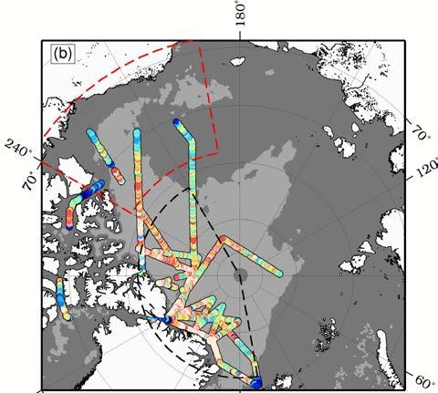
8 Coordinated Field Experiments, March 2014 Goal: Characterize snow depth on Arctic sea ice in a range of locations and varying snow conditions. Multiple field teams validate a suite of airborne radar and laser sensors 17 March, Barrow, AK: first year undeformed and deformed ice 18 March, Sachs Harbor: multiyear ice; lighter snow cover 30 March, Stn. Nord: Older, multiyear ice; heavier snow cover Background: ASCAT backscatter data indicates surface conditions, delineating FYI and MYI Credit: NASA Scatterometer Climate Record Pathfinder (SCP) Project ( From: Richter-Menge et al. (2014, in prep)


9 Arctic Field Work 2014 Barrow, Alaska: March 2014 Arctic Ocean: October 2014 NASA P-3B on the ramp at Fairbanks Intl Airport, Alaska 6 am Making visual observations of ice conditions Tom Newman participated in the NRL DISTANCE airborne project, March NRL aircraft conducted surveys above field teams and underflights of CryoSat-2 Alek Petty participated in the JOIS/Beaufort Gyre Exploration Project research cruise in the Beaufort Sea on board the CCGS Louis S. St Laurent, Relatively warm day at U. Alaska Fairbanks

 Maslanik et al.")
![[2011] reported that MY ice extent in the Arctic Ocean reached](/docs-images/89/100003586/images/10-4.jpg "record minimum in March 2008.")

10 Winter Sea Ice Conditions over Last Decade Multi-year ice First year ice EUMETSAT Ocean and Sea Ice Satellite Application Facilities (OSI-SAF) sea ice type product ( Maslanik et al. [2011] reported that MY ice extent in the Arctic Ocean reached record minimum in March Loss of MY ice was particularly dramatic in the western Arctic, including the Beaufort Sea and the Canada Basin March 2013 and 2014: Return of MY ice in Canada Basin reverting to 2005/2006 levels


11 Updated From: Richter-Menge and Farrell (2013)


12 Updated From: Richter-Menge and Farrell (2013)


13 MYI FYI Updated From: Richter-Menge and Farrell (2013)
14 Sea Ice Thickness in western Arctic has remained generally consistent over last six yrs, after dramatic drop in winter 2007/08 (Kwok et al. 2009; Giles et al., 2009) Mean thickness decreased slightly in winter 2013, after record min. in Sept 2012: ~ m (MYI) and ~ m (FYI) Central Arctic: Dominant multiyear ice (MYI) zone: 90% + Beaufort /Chukchi Sea (BC) Region: Mix of MYI and first-year ice: ~ 25 %: 75 % Persistent MYI tongue in Beaufort and Chukchi Seas in winter 2014 Slight rebound in ice thickness after winter 2013 Snow depth estimates from IceBridge now available for western Arctic Snow on multi-year ice consistent with snow climatology of Warren et al. (1999) Snow on first-year ice ~60 % of snow climatology See Tom Newman s presentation later today! A look ahead NASA s ICESat-2 due for launch in late 2017 with coverage to 88 o N/S 14
Optimizing Observations of Sea Ice Thickness and Snow Depth in the Arctic
 DISTRIBUTION STATEMENT A. Approved for public release; distribution is unlimited. Optimizing Observations of Sea Ice Thickness and Snow Depth in the Arctic Jacqueline A. Richter-Menge CRREL, 72 Lyme Road,
Optimizing Observations of Sea Ice Thickness and Snow Depth in the Arctic
 DISTRIBUTION STATEMENT A. Approved for public release; distribution is unlimited. Optimizing Observations of Sea Ice Thickness and Snow Depth in the Arctic Sinead L. Farrell University of Maryland, ESSIC
Sea Ice Observations: Where Would We Be Without the Arctic Observing Network? Jackie Richter-Menge ERDC-CRREL
 Sea Ice Observations: Where Would We Be Without the Arctic Observing Network? Jackie Richter-Menge ERDC-CRREL Sea Ice Observations: Where Would We Be Without the Arctic Observing Network? Jackie Richter-Menge
Optimizing Observations of Sea Ice Thickness and Snow Depth in the Arctic
 DISTRIBUTION STATEMENT A. Approved for public release; distribution is unlimited. Optimizing Observations of Sea Ice Thickness and Snow Depth in the Arctic Jacqueline A. Richter-Menge CRREL, 72 Lyme Road
Observations of Arctic snow and sea ice thickness from satellite and airborne surveys. Nathan Kurtz NASA Goddard Space Flight Center
 Observations of Arctic snow and sea ice thickness from satellite and airborne surveys Nathan Kurtz NASA Goddard Space Flight Center Decline in Arctic sea ice thickness and volume Kwok et al. (2009) Submarine
Mass balance of sea ice in both hemispheres Airborne validation and the AWI CryoSat-2 sea ice data product
 Mass balance of sea ice in both hemispheres Airborne validation and the AWI CryoSat-2 sea ice data product Stefan Hendricks Robert Ricker Veit Helm Sandra Schwegmann Christian Haas Andreas Herber Airborne
Determining the Impact of Sea Ice Thickness on the
 US NAVAL RESEARCH LABORATORY FIVE YEAR RESEARCH OPTION Determining the Impact of Sea Ice Thickness on the Arctic s Naturally Changing Environment (DISTANCE) Co-PI s for NRL John Brozena, Joan Gardner (Marine
Using Remote-sensed Sea Ice Thickness, Extent and Speed Observations to Optimise a Sea Ice Model
 Using Remote-sensed Sea Ice Thickness, Extent and Speed Observations to Optimise a Sea Ice Model Paul Miller, Seymour Laxon, Daniel Feltham, Douglas Cresswell Centre for Polar Observation and Modelling
Product Validation Report Polar Ocean
 Product Validation Report Polar Ocean Lars Stenseng PVR, Version 1.0 July 24, 2014 Product Validation Report - Polar Ocean Lars Stenseng National Space Institute PVR, Version 1.0, Kgs. Lyngby, July 24,
Precipitation, snow accumulation and sea ice thickness over the Arctic Ocean
 Precipitation, snow accumulation and sea ice thickness over the Arctic Ocean Alek Petty, Linette Boisvert, Melinda Webster, Thorsten Markus, Nathan Kurtz, Jeremy Harbeck www.alekpetty.com / @alekpetty
Applying High Resolution Imagery to Understand the Role of Dynamics in the Diminishing Arctic Sea Ice Cover
 DISTRIBUTION STATEMENT A. Approved for public release; distribution is unlimited. Applying High Resolution Imagery to Understand the Role of Dynamics in the Diminishing Arctic Sea Ice Cover Dr. Sinead
Remote sensing of sea ice
 Remote sensing of sea ice Ice concentration/extent Age/type Drift Melting Thickness Christian Haas Remote Sensing Methods Passive: senses shortwave (visible), thermal (infrared) or microwave radiation
Arctic sea ice thickness, volume, and multiyear ice coverage: losses and coupled variability ( )
") Environmental Research Letters LETTER OPEN ACCESS Arctic sea ice thickness, volume, and multiyear ice coverage: losses and coupled variability (1958 2018) To cite this article: R Kwok 2018 Environ. Res.
Environmental Research Letters LETTER OPEN ACCESS Arctic sea ice thickness, volume, and multiyear ice coverage: losses and coupled variability (1958 2018) To cite this article: R Kwok 2018 Environ. Res.
Welcome to PolarConnect. With Kelly McCarthy and NASA s Operation IceBridge
 Welcome to PolarConnect With Kelly McCarthy and NASA s Operation IceBridge 5 May 2016 If you are joining by phone, please mute your phone. Press *6 to mute and *6 to unmute. Participant Introductions In
Merged sea-ice thickness product from complementary L-band and altimetry information
 Merged sea-ice thickness product from complementary L-band and altimetry information Contributors AWI Team Stefan Hendricks Robert Ricker Stephan Paul University Hamburg Team Lars Kaleschke Xiangshan Tian-Kunze
Recent Improvements in the U.S. Navy s Ice Modeling Efforts Using CryoSat-2 Ice Thickness for Model Initialization
 Recent Improvements in the U.S. Navy s Ice Modeling Efforts Using CryoSat-2 Ice Thickness for Model Initialization Richard Allard 1, David Hebert 1, Pamela Posey 1, Alan Wallcraft 1, Li Li 2, William Johnston
Assessment of Contemporary Satellite Sea Ice Thickness Products for Arctic Sea Ice
 Assessment of Contemporary Satellite Sea Ice Thickness Products for Arctic Sea Ice Heidi Sallila 1, Joshua McCurry 2,3, Sinéad Louise Farrell 2,3 and Eero Rinne 1 1 Finnish Meteorological Institute, Helsinki,
In-situ and airborne sea ice observations for better sea ice prediction and climate analysis. Christian Haas
 In-situ and airborne sea ice observations for better sea ice prediction and climate analysis Christian Haas Data assimilation improves sea ice forecasts Most important parameters are: Concentration (SIC),
Observing Arctic Sea Ice Change. Christian Haas
 Observing Arctic Sea Ice Change Christian Haas Decreasing Arctic sea ice extent in September Ice extent is decreasing, but regional patterns are very different every year The Cryosphere Today, http://arctic.atmos.uiuc.edu;
CryoSat: ESA s Ice Mission:
 CryoSat: ESA s Ice Mission: 6 years in operations: status and achievements T. Parrinello CryoSat Mission Manager M. Drinkwater Mission Scientist CryoSat March 2016 sea-ice thickness CryoSat: A bit of history
Sea Ice Prediction Network (SIPN) Webinar: Industry Needs for Seasonal and Sub-seasonal Sea Ice Information and Predictions
 Webinar: Industry Needs for Seasonal and Sub-seasonal Sea Ice Information and Predictions") Sea Ice Prediction Network (SIPN) Webinar: Industry Needs for Seasonal and Sub-seasonal Sea Ice Information and Predictions Hajo Eicken International Arctic Research Center University of Alaska Fairbanks,
Sea Ice Prediction Network (SIPN) Webinar: Industry Needs for Seasonal and Sub-seasonal Sea Ice Information and Predictions Hajo Eicken International Arctic Research Center University of Alaska Fairbanks,
Geoid and MDT of the Arctic Ocean
 Geoid and MDT of the Arctic Ocean Rene Forsberg, Henriette Skourup Geodynamics Dept National Space Institute Techical University of Denmark rf@space.dtu.dk Outline: Determination of MDT from remote sensing
This is version v0.2 of this report issued together with the SIT and SIV data sets at the ICDC ESA-CCI- Projekt web page
 Report about Retrieval of sea-ice volume (SIV) from SICCI-2 sea-ice thickness (SIT) data and combined OSI-450 and SICCI-2 sea-ice concentration (SIC) data version v0.2, June 2018 by Stefan Kern, ICDC,
High-resolution airborne observations of sea-ice pressure ridge sail height
 Annals of Glaciology 59(76pt2) 2018 doi: 10.1017/aog.2018.2 137 The Author(s) 2018. This is an Open Access article, distributed under the terms of the Creative Commons Attribution-NonCommercial-NoDerivatives
Floating Ice: Progress in Addressing Science Goals
 Polar Floating Ice: Progress in Addressing Science Goals Stephen Howell 1, Leif Toudal Pedersen 2 and Roberto Saldo 3 1 Environment Canada, Climate Research Division, Toronto, Canada 2 Danish Meteorological
Observing Snow: Conventional Measurements, Satellite and Airborne Remote Sensing. Chris Derksen Climate Research Division, ECCC
 Observing Snow: Conventional Measurements, Satellite and Airborne Remote Sensing Chris Derksen Climate Research Division, ECCC Outline Three Snow Lectures: 1. Why you should care about snow 2. How we measure
Some NOAA Products that Address PSTG Satellite Observing Requirements. Jeff Key NOAA/NESDIS Madison, Wisconsin USA
 Some NOAA Products that Address PSTG Satellite Observing Requirements Jeff Key NOAA/NESDIS Madison, Wisconsin USA WMO Polar Space Task Group, 4 th meeting, Greenbelt, 30 September 2014 Relevant Missions
The Seasonal Evolution of Sea Ice Floe Size Distribution
 DISTRIBUTION STATEMENT A. Approved for public release; distribution is unlimited. The Seasonal Evolution of Sea Ice Floe Size Distribution Jacqueline A. Richter-Menge and Donald K. Perovich CRREL, 72 Lyme
Dual-Frequency Ku- Band Radar Mission Concept for Snow Mass
 Dual-Frequency Ku- Band Radar Mission Concept for Snow Mass Chris Derksen Environment and Climate Change Canada Study Team: Climate Research Division/Meteorological Research Division, ECCC Canadian Space
Small-scale horizontal variability of snow, sea-ice thickness and freeboard in the first-year ice region north of Svalbard
 Annals of Glaciology 54(62) 2013 doi:10.3189/2013aog62a157 261 Small-scale horizontal variability of snow, sea-ice thickness and freeboard in the first-year ice region north of Svalbard Jari HAAPALA, 1
Spectral Albedos. a: dry snow. b: wet new snow. c: melting old snow. a: cold MY ice. b: melting MY ice. d: frozen pond. c: melting FY white ice
 Spectral Albedos a: dry snow b: wet new snow a: cold MY ice c: melting old snow b: melting MY ice d: frozen pond c: melting FY white ice d: melting FY blue ice e: early MY pond e: ageing ponds Extinction
Evaluating the Discrete Element Method as a Tool for Predicting the Seasonal Evolution of the MIZ
 DISTRIBUTION STATEMENT A. Approved for public release; distribution is unlimited. Evaluating the Discrete Element Method as a Tool for Predicting the Seasonal Evolution of the MIZ Arnold J. Song Cold Regions
Office of Naval Research Update and Status of Arctic Environmental Programs
 Office of Naval Research Update and Status of Arctic Environmental Programs October 2017 CDR Blake McBride Deputy, Ocean, Atmosphere and Space Research Division Office of Naval Research marvin.mcbride@navy.mil
Sea Ice Growth And Decay. A Remote Sensing Perspective
 Sea Ice Growth And Decay A Remote Sensing Perspective Sea Ice Growth & Decay Add snow here Loss of Sea Ice in the Arctic Donald K. Perovich and Jacqueline A. Richter-Menge Annual Review of Marine Science
Remote Sensing 4 Global mass changes from remote sensing
 Remote Sensing 4 Global mass changes from remote sensing Nick Barrand School of Geography, Earth & Environmental Sciences University of Birmingham, UK Why glacier mass changes? o Water resources o Energy
LEGOS Altimetric Sea Ice Thickness Data Product v1.0
 LEGOS Altimetric Sea Ice Thickness Data Product v1.0 (a) Ice thickness c2 02/2015 (m) 3.24 2.88 2.52 2.16 1.80 1.44 1.08 0.72 0.36 0.00 Authors: Kevin Guerreiro & Sara Fleury September 2017 (b) Incertitude
The ICESat 2 Mission Laser altimetry of ice, clouds and land elevation
 OSTM SWT San Diego October 2011 The ICESat 2 Mission Laser altimetry of ice, clouds and land elevation and also ocean, coastal, and continental waters Charon Birkett, ESSIC/UMD on behalf of T. Markus,
This is a repository copy of Increased Arctic sea ice volume after anomalously low melting in 2013.
 This is a repository copy of Increased Arctic sea ice volume after anomalously low melting in 2013. White Rose Research Online URL for this paper: http://eprints.whiterose.ac.uk/92413/ Version: Accepted
Julia Figa-Saldaña & Klaus Scipal
 Julia Figa-Saldaña & Klaus Scipal julia.figa@eumetsat.int klaus.scipal@esa.int Meeting, Outline MetOp/EPS status MetOp/EPS Second Generation status 2016 scatterometer conference Other European ocean programme
Large scale surveys of snow depth on Arctic sea ice from Operation IceBridge
 GEOPHYSICAL RESEARCH LETTERS, VOL. 38,, doi:10.1029/2011gl049216, 2011 Large scale surveys of snow depth on Arctic sea ice from Operation IceBridge Nathan T. Kurtz 1,2 and Sinead L. Farrell 2,3 Received
An Assessment of the Navy's Sea Ice Outlook Predictions for 2014
 An Assessment of the Navy's Sea Ice Outlook Predictions for 2014 Pam Posey 1, Rick Allard 1, David Hebert 1, Joe Metzger 1, Ruth Preller 1, Alan Wallcraft 1, Ole Martin Smedstad 2, Michael Phelps 3 and
Airborne sea ice thickness sounding
 Airborne sea ice thickness sounding 1, Christian Haas 2, Lasse Rabenstein 1, John Lobach 3 1. Alfred Wegener Institute for Polar and Marine Research, Germany 2. University of Alberta, Canada 3. Ferra Dynamics
TECH NOTE. New Mean Sea Surface for the CryoSat-2 L2 SAR Chain. Andy Ridout, CPOM, University College London
 TECH NOTE Subject : From : To : New Mean Sea Surface for the CryoSat-2 L2 SAR Chain Andy Ridout, CPOM, University College London Tommaso Parrinello, CryoSat Mission Manager, ESRIN Date : 30 th June 2014
Sea-ice change around Alaska & Impacts on Human Activities
 Sea-ice change around Alaska & Impacts on Human Activities Hajo Eicken Geophysical Institute University of Alaska Fairbanks, hajo.eicken@gi.alaska.edu Introduction The Arctic sea-ice cover: Observations
FAMOS for YOPP Forum for Arctic Modeling and Observational Synthesis (FAMOS) for Year of Polar Prediction (YOPP)
 for Year of Polar Prediction (YOPP)") FAMOS for YOPP Forum for Arctic Modeling and Observational Synthesis (FAMOS) for Year of Polar Prediction (YOPP) Andrey Proshutinsky (Woods Hole Oceanographic Institution) and research FAMOS team YOPP-Summit
FAMOS for YOPP Forum for Arctic Modeling and Observational Synthesis (FAMOS) for Year of Polar Prediction (YOPP) Andrey Proshutinsky (Woods Hole Oceanographic Institution) and research FAMOS team YOPP-Summit
Accelerated decline in the Arctic sea ice cover
 Click Here for Full Article GEOPHYSICAL RESEARCH LETTERS, VOL. 35, L01703, doi:10.1029/2007gl031972, 2008 Accelerated decline in the Arctic sea ice cover Josefino C. Comiso, 1 Claire L. Parkinson, 1 Robert
IABP Deployment Plans for 2004
 IABP Buoy Positions IABP Deployment Plans for 2004 SPRING NPEO (Multiple buoys provided by NOAA/PMEL, JAMSTEC, & CRREL) EC/NIC- CES (80N 120W, & 80N 130W) SUMMER IARC/NABOS Cruise 2 NOAA-PSC IMB (North
Regional Outlook for the Bering-Chukchi-Beaufort Seas Contribution to the 2018 Sea Ice Outlook
 Regional Outlook for the Bering-Chukchi-Beaufort Seas Contribution to the 2018 Sea Ice Outlook 25 July 2018 Matthew Druckenmiller (National Snow and Ice Data Center, Univ. Colorado Boulder) & Hajo Eicken
Sea Ice Motion: Physics and Observations Ron Kwok Jet Propulsion Laboratory California Institute of Technology, Pasadena, CA
 Sea Ice Motion: Physics and Observations Ron Kwok Jet Propulsion Laboratory California Institute of Technology, Pasadena, CA 7 th ESA Earth Observation Summer School ESRIN, Frascati, Italy 4-14 August
Arctic Ocean Mean Sea Surface, Geoid and Gravity from Surface Data, Icesat and GRACE a reference for Cryosat sea-ice mapping
 Arctic Ocean Mean Sea Surface, Geoid and Gravity from Surface Data, Icesat and GRACE a reference for Cryosat sea-ice mapping R. Forsberg and H. Skourup, Geodynamics Dept., DNSC rf@spacecenter.dk Arctic
U.S. Arctic Campaign Scenario
 Prepared by the NOAA Office of Ocean Exploration and Research for Nation Ocean Exploration Forum 2016: Beyond the Ships. Sea ice extent from National Snow Service Layer Credits: NOAA National Centers for
 Page 1 of 10 Search NSIDC... Search Education Center Photo Gallery Home Data Programs & Projects Science Publications News & Events About Overview Global Temperatures Northern Hemisphere Snow Glaciers
Recent changes in the dynamic properties of declining Arctic sea ice: A model study
 GEOPHYSICAL RESEARCH LETTERS, VOL. 39,, doi:10.1029/2012gl053545, 2012 Recent changes in the dynamic properties of declining Arctic sea ice: A model study Jinlun Zhang, 1 Ron Lindsay, 1 Axel Schweiger,
The Seasonal Evolution of Sea Ice Floe Size Distribution
 DISTRIBUTION STATEMENT A. Approved for public release; distribution is unlimited. The Seasonal Evolution of Sea Ice Floe Size Distribution Jacqueline A. Richter-Menge and Donald K. Perovich CRREL 72 Lyme
Experiences of using ECV datasets in ECMWF reanalyses including CCI applications. David Tan and colleagues ECMWF, Reading, UK
 Experiences of using ECV datasets in ECMWF reanalyses including CCI applications David Tan and colleagues ECMWF, Reading, UK Slide 1 Main points Experience shows benefit of integrated & iterative approach
Notes for Remote Sensing: Glacier Elevation, Volume and Mass Change
 Notes for Remote Sensing: Glacier Elevation, Volume and Mass Change Elevation and Volume Change: Alex S Gardner Atmospheric Oceanic and Space Sciences, University of Michigan Aircraft- and satellite- mounted
Arctic sea ice falls below 4 million square kilometers
 SOURCE : http://nsidc.org/arcticseaicenews/ Arctic sea ice falls below 4 million square kilometers September 5, 2012 The National Snow and Ice Data Center : Advancing knowledge of Earth's frozen regions
Seasonal forecasts of Arctic sea ice initialized with observations of ice thickness
 GEOPHYSICAL RESEARCH LETTERS, VOL. 39,, doi:10.1029/2012gl053576, 2012 Seasonal forecasts of Arctic sea ice initialized with observations of ice thickness R. Lindsay, 1 C. Haas, 2 S. Hendricks, 3 P. Hunkeler,
Fri. Apr. 06, Map Projections Environmental Applications. Reading: Finish Chapter 9 ( Environmental Remote Sensing )
") Fri. Apr. 06, 2018 Map Projections Environmental Applications Reading: Finish Chapter 9 ( Environmental Remote Sensing ) Once again -- Satellites old but principles still apply Skim Sabins Chapter 10.
Fri. Apr. 06, 2018 Map Projections Environmental Applications Reading: Finish Chapter 9 ( Environmental Remote Sensing ) Once again -- Satellites old but principles still apply Skim Sabins Chapter 10.
IMPORTANCE OF SATELLITE DATA (FOR REANALYSIS AND BEYOND) Jörg Schulz EUMETSAT
 Jörg Schulz EUMETSAT") IMPORTANCE OF SATELLITE DATA (FOR REANALYSIS AND BEYOND) Jörg Schulz EUMETSAT Why satellite data for climate monitoring? Global coverage Global consistency, sometimes also temporal consistency High spatial
IMPORTANCE OF SATELLITE DATA (FOR REANALYSIS AND BEYOND) Jörg Schulz EUMETSAT Why satellite data for climate monitoring? Global coverage Global consistency, sometimes also temporal consistency High spatial
Sea ice as a key climate indicator in the Arctic
 Sea ice as a key climate indicator in the Arctic Leif Toudal Pedersen, DMI Natalia Ivanova, NERSC Eero Rinne, FMI Roberto Saldo, DTU Georg Heygster, U-Bremen Rasmus Tonboe, DMI Thomas Lavergne, Met Norway
Korean Arctic Research 2015 update
 FARO Annual Meeting, ASSW 2016 Fairbanks, Alaska, 12 March 2016 Korean Arctic Research 2015 update International Cooperation Department Korea Polar Research Institute Outline KOPRI and Korean Arctic research;
Seasonal Ice Zone Reconnaissance Surveys Coordination
 DISTRIBUTION STATEMENT A. Approved for public release; distribution is unlimited. Seasonal Ice Zone Reconnaissance Surveys Coordination phone: (206) 543 1394 James Morison Polar Science Center, APL-UW
Development of sea ice climate data records. W. Meier
 Development of sea ice climate data records W. Meier WOAP Workshop, Frascati, Italy, 18 April 2011 Passive microwave sea ice data 32+ year record able to track long-term trends Near-complete, daily fields
Ice, Cloud, and land Elevation Satellite (ICESat) over Arctic sea ice: Retrieval of freeboard
 over Arctic sea ice: Retrieval of freeboard") Click Here for Full Article JOURNAL OF GEOPHYSICAL RESEARCH, VOL. 112,, doi:1.129/26jc3978, 27 Ice, Cloud, and land Elevation Satellite (ICESat) over Arctic sea ice: Retrieval of freeboard R. Kwok, 1 G.
Click Here for Full Article JOURNAL OF GEOPHYSICAL RESEARCH, VOL. 112,, doi:1.129/26jc3978, 27 Ice, Cloud, and land Elevation Satellite (ICESat) over Arctic sea ice: Retrieval of freeboard R. Kwok, 1 G.
Visible and Thermal Imaging of Sea Ice and Open Water from Coast Guard Arctic Domain Awareness Flights
 DISTRIBUTION STATEMENT A. Approved for public release; distribution is unlimited. Visible and Thermal Imaging of Sea Ice and Open Water from Coast Guard Arctic Domain Awareness Flights Ronald Lindsay Applied
An account of fieldwork in the Arctic Ocean
 An account of fieldwork in the Arctic Ocean Katharine Giles Centre for Polar Observation and Modelling, University College London 2007 marked the start of the 4th International Polar Year (IPY 2007 2008),
Analysis of CryoSat s radar altimeter waveforms over different Arctic sea ice regimes
 53 Analysis of CryoSat s radar altimeter waveforms over different Arctic sea ice regimes Marta Zygmuntowska, Kirill Khvorostovsky Nansen Environmental and Remote Sensing Center Abstract Satellite altimetry
Ice in a changing climate
 Ice in a changing climate ESA$Ice$sheets$CCI$$ Phase$1$Results$&$Contribu8on$to$Climate$ Research$ $ $ R"Forsberg,"L"Sørensen,"R"Meister,"J"Levinsen,"" J"Dall,"A"Kusk"(DTU>Space,"Denmark)" T"Nagler"(ENVEO,"Austria)"
NSIDC Sea Ice Outlook Contribution, 31 May 2012
 Summary NSIDC Sea Ice Outlook Contribution, 31 May 2012 Julienne Stroeve, Walt Meier, Mark Serreze, Ted Scambos, Mark Tschudi NSIDC is using the same approach as the last 2 years: survival of ice of different
The relation between sea ice thickness and freeboard in the Arctic
 The Cryosphere, 4, 373 380, 2010 doi:10.5194/tc-4-373-2010 Author(s) 2010. CC Attribution 3.0 License. The Cryosphere The relation between sea ice thickness and freeboard in the Arctic V. Alexandrov 1,2,
SSH retrieval in the ice covered Arctic Ocean: from waveform classification to regional sea level maps
 ESA Climate Change Initiative SSH retrieval in the ice covered Arctic Ocean: from waveform classification to regional sea level maps CLS LEGOS PML Arctic SIE status 2 nd lowest on record with 4.14 10 6
The Arctic Sea Ice Cover
 The Arctic Sea Ice Cover From the Living Earth Interface, Impediment, Integrator Frozen ocean 8-15 million km 2 Size of U.S. Meters thick Floating, moving ice Highly variable Large albedo Climate change!
Loan 867. Calibration and validation of the CryoSat radar altimeter: field studies on the Greenland Ice Sheet.
 Loan 867. Calibration and validation of the CryoSat radar altimeter: field studies on the Greenland Ice Sheet. Elizabeth M. MORRIS Scott Polar Research Institute, Lensfield Road, Cambridge CB2 1ER, UK.
CryoSat-2: A new perspective on Antarctica
 CryoSat-2: A new perspective on Antarctica K. Briggs 1, R. Cullen 2, L. Foresta 3, R. Francis 2, A. Hogg 1, M. McMillan 1, A. Muir 4, N. Galin 4, L. Gilbert 4, N. Gourmelen 3, A. Ridout 4, A. Shepherd
CEOS and Climate monitoring
 CEOS and Climate monitoring Committee on Earth Observation Satellites www.ceos.org Climate challenges and the need for observations Observations play a crucial role in the detection of climate change and
WRF Historical and PGW Simulations over Alaska
 WRF Historical and PGW Simulations over Alaska Andrew J. Newman 1, Andrew J. Monaghan 2, Martyn P. Clark 1, Kyoko Ikeda 1, Lulin Xue 1, and Jeff R. Arnold 3 GEWEX CPCM Workshop II 1 National Center for
Mass Balance of Multiyear Sea Ice in the Southern Beaufort Sea
 DISTRIBUTION STATEMENT A. Approved for public release; distribution is unlimited. Mass Balance of Multiyear Sea Ice in the Southern Beaufort Sea PI Andrew R. Mahoney Geophysical Institute University of
Arctic Regional Ocean Observing System Arctic ROOS Report from 2012
 Arctic Regional Ocean Observing System Arctic ROOS Report from 2012 By Stein Sandven Nansen Environmental and Remote Sensing Center (www.arctic-roos.org) Focus in 2012 1. Arctic Marine Forecasting Center
Possible Applications of Deep Neural Networks in Climate and Weather. David M. Hall Assistant Research Professor Dept. Computer Science, CU Boulder
 Possible Applications of Deep Neural Networks in Climate and Weather David M. Hall Assistant Research Professor Dept. Computer Science, CU Boulder Quick overview of climate and weather models Weather models
Office of Naval Research Arctic Observing Activities
 Office of Naval Research Arctic Observing Activities Jim Thomson Applied Physics Laboratory, University of Washington jthomson@apl.washington.edu Scott L. Harper, Program Officer, Arctic and Global Prediction
Three years of sea ice freeboard, snow depth, and ice thickness of the Weddell Sea from Operation IceBridge and CryoSat-2
 Three years of sea ice freeboard, snow depth, and ice thickness of the Weddell Sea from Operation IceBridge and CryoSat-2 Ron Kwok 1, Sahra Kacimi 1 1 Jet Propulsion Laboratory, California Institute of
EUMETSAT STATUS AND PLANS
 1 EUM/TSS/VWG/15/826793 07/10/2015 EUMETSAT STATUS AND PLANS François Montagner, Marine Applications Manager, EUMETSAT WMO Polar Space Task Group 5 5-7 October 2015, DLR, Oberpfaffenhofen PSTG Strategic
Annual Progress Report Year 1 (3 June June 2009)
") Annual Progress Report Year 1 (3 June 2008-2 June 2009) Project Title: Antarctic sea ice thickness from space: validating estimates from the laser and radar satellite altimeters with ship-based measurements
Annual Progress Report Year 1 (3 June 2008-2 June 2009) Project Title: Antarctic sea ice thickness from space: validating estimates from the laser and radar satellite altimeters with ship-based measurements
Major NASA activities in the Arctic
 Major NASA activities in the Arctic Arctic sea ice extent and thickness is declining The last four years have seen the lowest four minimum extents ever recorded for Arctic sea ice. NASA s researchers and
Remote Sensing I: Basics
 Remote Sensing I: Basics Kelly M. Brunt Earth System Science Interdisciplinary Center, University of Maryland Cryospheric Science Laboratory, Goddard Space Flight Center kelly.m.brunt@nasa.gov (Based on
ASCAT NRT Data Processing and Distribution at NOAA/NESDIS
 ASCAT NRT Data Processing and Distribution at NOAA/NESDIS Paul S. Chang, Zorana Jelenak, Seubson Soisuvarn, Qi Zhu Gene Legg and Jeff Augenbaum National Oceanic and Atmospheric Administration (NOAA) National
ESA Climate Change Initiative (CCI)
") ESA Climate Change Initiative (CCI) New ESA Programme with the aim to contribute to worldwide efforts to generate Essential Climate Variables (ECVs) C. Zehner Barcelona, 07/09/2009 Two climate action paths
ESA Climate Change Initiative (CCI) New ESA Programme with the aim to contribute to worldwide efforts to generate Essential Climate Variables (ECVs) C. Zehner Barcelona, 07/09/2009 Two climate action paths
NOAA/NESDIS Contributions to the International Polar Year (IPY)
") NOAA/NESDIS Contributions to the International Polar Year (IPY) WMO Space Task Group for IPY 5-66 May 2008 Frascati, Italy Jeff Key and Pablo Clemente-Col Colón Overview NESDIS is responsible for operational
NOAA/NESDIS Contributions to the International Polar Year (IPY) WMO Space Task Group for IPY 5-66 May 2008 Frascati, Italy Jeff Key and Pablo Clemente-Col Colón Overview NESDIS is responsible for operational
Antarctic sea ice is a crucial component of the global
 US CLIVAR VARIATIONS Improving our understanding of Antarctic sea ice with NASA's Operation IceBridge and the upcoming ICESat-2 mission Alek A. Petty 1,2, Thorsten Markus 2, and Nathan T. Kurtz 2 1 University
EC-PORS III Research. Sodankylä, February Developing a Polar Prediction System
 EC-PORS III Research Sodankylä, February 2012 Developing a Polar Prediction System Polar Prediction System - Status 1. EC-PORS I (Oct. 2009) -> initial discussions 2. WWRP/THORPEX Polar Prediction Workshop,
Visible and Thermal Imaging of Sea Ice and Open Water from Coast Guard Arctic Domain Awareness Flights
 DISTRIBUTION STATEMENT A. Approved for public release; distribution is unlimited. Visible and Thermal Imaging of Sea Ice and Open Water from Coast Guard Arctic Domain Awareness Flights Chris Chickadel
Changing Marine Access in the Arctic Ocean: The Arctic Climate Impact Assessment Panama Canal Authority 11 January 2005
 Changing Marine Access in the Arctic Ocean: The Arctic Climate Impact Assessment Panama Canal Authority 11 January 2005 Lawson Brigham Deputy Director, U.S. Arctic Research Commission ACIA Contributing
Ice sheet mass balance from satellite altimetry. Kate Briggs (Mal McMillan)
") Ice sheet mass balance from satellite altimetry Kate Briggs (Mal McMillan) Outline Background Recap 25 year altimetry record Recap Measuring surface elevation with altimetry Measuring surface elevation
Ice sheet mass balance from satellite altimetry Kate Briggs (Mal McMillan) Outline Background Recap 25 year altimetry record Recap Measuring surface elevation with altimetry Measuring surface elevation
QUALITY INFORMATION DOCUMENT For Arctic Ice Extent Indicator. ARC_SEAICE_INDEX_002
 QUALITY INFORMATION DOCUMENT For Arctic Ice Extent Indicator. Issue: 1.2 Contributors: Steinar Eastwood, Lars-Anders Breivik, Bruce Hackett, Thomas Lavergne, Gorm Dybkjær, Cecilie Wettre Approval Date
The thinning of Arctic sea ice Ronald Kwok and Norbert Untersteiner
 feature The thinning of Arctic sea ice Ronald Kwok and Norbert Untersteiner The surplus heat needed to explain the loss of Arctic sea ice during the past few decades is on the order of 1 W/m 2. Observing,
June Report: Outlook Based on May Data Regional Outlook: Beaufort and Chuckchi Seas, High Arctic, and Northwest Passage
 June Report: Outlook Based on May Data Regional Outlook: Beaufort and Chuckchi Seas, High Arctic, and Northwest Passage Charles Fowler, Sheldon Drobot, James Maslanik; University of Colorado James.Maslanik@colorado.edu
Sea ice thickness. Ed Blanchard-Wrigglesworth University of Washington
 Sea ice thickness Ed Blanchard-Wrigglesworth University of Washington Sea ice thickness Ed Blanchard-Wrigglesworth University of Washington Part II: variability Sea ice thickness Ed Blanchard-Wrigglesworth
Climate Models and Snow: Projections and Predictions, Decades to Days
 Climate Models and Snow: Projections and Predictions, Decades to Days Outline Three Snow Lectures: 1. Why you should care about snow 2. How we measure snow 3. Snow and climate modeling The observational
Weather and ice information as a tool for arctic marine and offshore services
 Weather and ice information as a tool for arctic marine and offshore services World Meteorological Organization Executive Council Panel of Experts on Polar Observations, Research and Services President