NOAA/NESDIS Contributions to the International Polar Year (IPY)
|
|
|
- Anna Davidson
- 5 years ago
- Views:
Transcription
 WMO")

1 NOAA/NESDIS Contributions to the International Polar Year (IPY) WMO Space Task Group for IPY 5-66 May 2008 Frascati, Italy Jeff Key and Pablo Clemente-Col Colón
2 Overview NESDIS is responsible for operational weather satellites,, in contrast to NASA, which designs and operates research satellites. NESDIS does not operate any active microwave sensors. NESDIS products are global and there are generally no scheduling conflicts. cts. NESDIS is contributing to the IPY by providing: experimental and operational snow, ice, atmosphere, and space products, compiling an IPY bibliography, and performing research on new satellite products and data assimilation. ion. NESDIS leads an effort to coordinate, evaluate, and enhance the global observing system for the cryosphere (snow and ice). This process is implemented as the Integrated Global Observing Strategy (IGOS) Cryosphere Theme, which has a near-term goal of providing a legacy of IPY observations and a long-term goal of a robust cryosphere observing system that will be part of the Global Earth Observation System of Systems (GEOSS). Many NOAA satellite datasets and products are supporting IPY activities, though there are only a few IPY-specific NESDIS activities.
3 What s s New NESDIS is now supporting the implementation of some real-time products as well as the reprocessing of others. Real-time atmosphere and cryosphere products at direct broadcast (DB) sites: Parameters: : polar winds, cloud properties (amount, phase, height, optical depth, particle size), surface temperature and albedo, ice extent, concentration, motion, and thickness, snow cover Instruments: : MODIS (Terra and Aqua) and AVHRR (NOAA-15, - 16, -17, -18). Satellites are site-dependent. MODIS DB Sites: : McMurdo, Antarctica, Tromsø,, Norway, Sodandylä,, Finland, Fairbanks, Alaska. AVHRR HRPT Sites: : Barrow, Alaska, Rothera,, Antarctica (UK), Davis or Casey, Antarctica (Australia). Note STG2, A2 action (more on that later). Not all products will be available at all sites.
4 Reprocessing: What s s New, cont. AVHRR Polar Pathfinder extended (APP-x), 1982-present AVHRR polar winds, 1982-present Historical products will be tied into real-time products, but will be periodically reprocessed for consistency. National Ice Center (NIC): The T NIC is improving its sea ice analysis in the Antarctic region with the availability of ESA Envisat ASAR background data and products. The NIC expects to be increasingly dependent on such data over both polar regions as we lose access to the Canadian R-1 data. (Issue from PC-C: We are losing access to the vast amount of Canadian RADARSAT-1 SAR data acquisitions we have enjoyed over Alaska during more than a decade. We are now trying to establish in a long-term collaboration with Canada leading to a government-to-government agreement for the U.S. to participate in the operational RADARSAT-Constellation mission to begin in 2013.)
5 NESDIS Satellite Products Relevant to IPY Polar-specific Products Polar winds Real-time: from MODIS, bent-pipe and direct broadcast. AVHRR winds from NOAA and MetOp satellites; HRPT sites expanding. Historical: from AVHRR, , both poles. Will be reprocessed and extended. Cloud properties, surface temperature and albedo, radiative fluxes from AVHRR Real-time: Once daily, both poles Extended AVHRR Polar Pathfinder (APP-x), both poles, twice daily, Will be extended. MODIS direct broadcast products: Winds, cloud properties, temperature inversion characteristics, surface temperature and albedo. Snow and ice products are being added. Generated in real-time at direct broadcast sites in Norway, Finland, Antarctica Development of a similar system at Fairbanks, Alaska (Gilmore Creek) is underway. The National Ice Center (NIC) produces operational hemispheric sea ice analyses for both polar regions using national and international satellite assets. In addition, the NIC is participating in research and validation of radar altimetry observations over Arctic sea ice for the measurement of ice thickness, also developing experimental sea ice coverage charts for the Polar Regions from QuikSCAT scatterometer backscatter data, in collaboration with NASA/JPL, developing/updating Arctic and Antarctic ice chart climatologies, transferring of the Operational Snow and Ice Analysis and Mapping System to the NIC, a participant in the GMES Polar View IPY Activities ( Synthetic aperture radar (SAR) research activities. NIC provides the Alaska Region with imagery and experimental derived products for safety of fisheries, marine transportation, and low-flying aircraft. Ice imagery for Arctic, coastal, and river ice analyses Storm imagery for mesoscale storm prediction High-resolution winds for coastal wind analyses and climate studies.
6 NESDIS Satellite Products Relevant to IPY Global Products Hydrological Products (Snow cover/swe; precipitation, water vapor, sea-ice, etc.): Daily snow and ice cover at Real-time from POES/AMSU (see and including snow cover, snow water equivalent, cloud water, land surface temperature, rain rate, total precipitable water. Archived at CLASS (2000 to present); pentad and monthly products (see Real-time from DMSP/SSMI (see NG.html). Archived at CLASS ( present); Monthly products ( present) archived at NCDC (see Real-time from Aqua/AMSR-E (see Atmospheric temperature and humidity from AIRS and IASI. Ocean products (SST, winds, etc.) at: Measurements of auroral particle precipitation from the polar-orbiting POES satellites. NGDC is helping provide NOAA space weather data and analysis in collaborative research efforts with IPY scientists.
7 NESDIS Non-Satellite Products Relevant to IPY National Oceanographic Data Center participating in:: Preparation of oceanographic atlas and database of the Sub-Arctic Seas by the Ocean Climate Laboratory Division (OC5): Atlas and accompanying CD-ROM will contain oceanographic data collected for the Sub- Arctic seas with anticipated monthly data distribution plots for each year; monthly climatic maps of temperature and salinit. The Atlas will also include, in electronic format, selected copies of rare books and articles about the history of the sub-arctic exploration and climate studies as well as photos, which provide information about the people and environment of this region. NOAA Central Library (OC4) - Preparation of a printed and online bibliography of NOAA library polar resources ( ): "International Polar Year Resources on Polar Research in the NOAA Central Library Network: A Selected Bibliography" - links to over hundred and fifty historically unique documents and other resources on exploration and research in the Polar Regions from the 18th century to the present. A four sections Bibliography: 1. What is the International Polar Year? 2. Historical resources on Polar research in the NOAA Central Library Special Collections. 3. Current resources on Polar research in the NOAA Central Library Network. 4. Internet resources on Polar research. A Polar Resources webpage in the NOAA Library Network home page has been prepared to support the Agency and NOAA Central Library (NCL) activities during International Polar Year ( A Polar Poster has been developed in the NOAA Central Library to provide a visual display of the unique historical and contemporary Polar Resources in the NOAA Library Network. The poster has been also requested and sent to the National Archive and Records Administration (NARA) to be kept for posterity. (PDF with abstract) (JPEG for easy access) (TIFF for archiving)
8 AON Non-Satellite (and non-nesdis) Data Relevant to IPY Arctic Observing Network (AON): 100% International Arctic Observing Network (AON) goal: 21 ice-tethered buoys 60 ice buoys 21 ice mass balance buoys 68 oceanographic moorings (serviced once per year) 19 annual ship line 6 coastal climate observatories (Barrow, Eureka, Tiksi, Summit, Ny Alesund, Alert). 100% NOAA component of the AON goal: 54 Ice Buoys = 30 International Arctic Buoy Program + 12 IMB + 12 Tethered Platforms 40 Moorings = 10 pairs Pathway + 8 pairs Gateway + 8 Bering/Chukchi Seas + 4 Deep Western Boundary Current 12 Annual Ship Lines = 5 Pathway + 2 Gateway + 4 Bering/Chukchi Seas + 1 Deep Western Boundary Current to service the buoys & moorings and provide physical, chemical and biological data to describe changes in Arctic Ocean climate and impacts to ecosystems. 4 Coastal Observatories: Eureka, Tiksi, Greenland Summit, and Ny Alesund Note: Coastal Observatories: A system of strategically located, long-term Atmospheric Observatories will be developed around the Arctic to carry out both routine measurements made at meteorological stations and intensive measurements at the surface and through the depth of the atmosphere. Among the quantities to be measured are solar radiation, aerosols, air chemistry, trace gases, cloud properties, water vapor, ozone, temperatures, winds, precipitation, surface albedo, and stratospheric properties. These measurements are essential to calibrate and validate satellite sensors and to improve the reliability of climate models.

9 Clouds and Radiation AVHRR Cloud amount, height, phase, optical depth, particle size; surface temperature and albedo; surface and top-of-atmosphere radiation. Coming soon: snow cover, ice extent, ice motion, concentration, and thickness


10 Polar Winds AVHRR, METOP, MODIS MODIS: bent-pipe, MODIS direct broadcast, Terra & Aqua separately and combined; AVHRR: GAC, HRPT, NOAA & MetOp (with EUMETSAT) satellites; historical GAC
11 Some Receiving Station Masks in the Arctic and Antarctic Station masks for Fairbanks, Alaska Tromsø, Norway Svalbard Station masks for McMurdo Troll (Norway)

12 Examples of Direct Broadcast Products
 on March 31,")


 and")


13 Ice Products MODIS Aqua true color image (left) on March 31, 2006 over Kara Sea, and derived surface skin temperature in Kelvin degree (middle), and ice concentration in percentage (right). Comparison of sea ice thickness distribution measured by submarine ULS (solid line) and observed by AVHRR (dotted line) in terms of cumulative frequency along the submarine track during the Scientific Ice Expedition (SCICEX) from April 2 ~ May 13, An example of ice motion over the Arctic from MODIS on 4 May 2008.

14 DB Products on the Web
. ERA-40 used as background. ERA- 40 is ECMWF s 1957-2002 reanalysis product. Pros: An essential product for reanalysis projects.")
15 Historical AVHRR Polar Winds January 1, 1982 to August 31, One satellite at any given time, NOAA-7, -9, -11, -14, -16. Global Area Coverage (GAC) data gridded at 5 km. Cloud-track winds using IR channel only (no water vapor channel). ERA-40 used as background. ERA- 40 is ECMWF s reanalysis product. Pros: An essential product for reanalysis projects. Cons: Low resolution. Currently only one satellite at any given time. Height assignment uncertainty for thin clouds.

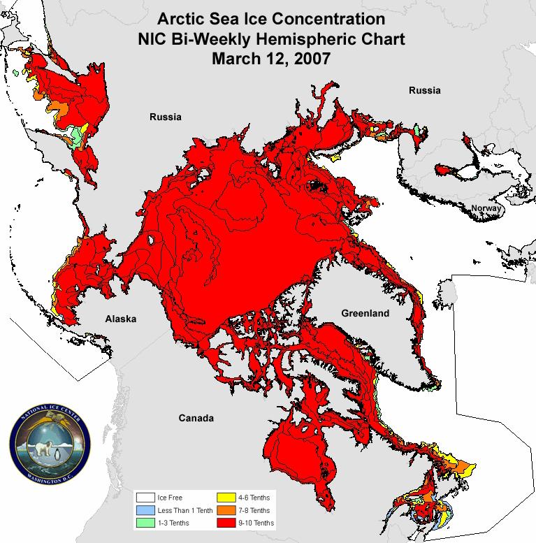
16 NIC
 images are acquired both day and night regardless of weather conditions.")
17 2007 Arctic Sea Ice Extent Record Minimum Captured by CSA RADARSAT-1 The Alaska Satellite Facility (ASF) downlinks and mosaics Canadian Space Agency (CSA) RADARSAT- 1 images of the western Arctic Ocean every three days. These synthetic aperture radar (SAR) images are acquired both day and night regardless of weather conditions. The data are used for research and operational monitoring of changes in sea ice cover. The National Ice Center (NIC) provides the Alaska Region with synthetic aperture radar (SAR) imagery and experimental derived products for safety of fisheries, marine transportation, and low-flying aircraft.
18


19 Improve Antarctic Hemispheric Coverage Sea Ice Extent and Concentration IPY Plans Enhancement of the analyses through increased used of Envisat data. Extension of the sea ice partial concentration analysis to all Antarctic regions (presently only done for the Ross Sea) This analysis can be used to produce an ice thickness proxy chart Development of an MIZ product Completion of the Antarctic sea ice chart climatology Manpower analysis to support a weekly ice charting of the Antarctic region.

20 NOAA Operational Snow and Ice Products

21 Surface and Precipitation Products


22 NOAA Central Library IPY
23 Other Items


24 STG2-A2 To investigate feasibility of establishing a single consolidated AVHRR 1 km Antarctic dataset This would be a nice international effort, particularly if historical 1 km data could be recovered and/or it continues into the future rather than just a snapshot. If only a snapshot, why AVHRR HRPT? Why not MODIS? MODIS data are available from a single source, at 1 km, 500 m, and 250 m, with more spectral information. What about NSIDC s Mosaic of Antarctica (MOA) Image map? Why not MetOp AVHRR, with global 1 km data? HRPT Station Masks
25
Some NOAA Products that Address PSTG Satellite Observing Requirements. Jeff Key NOAA/NESDIS Madison, Wisconsin USA
 Some NOAA Products that Address PSTG Satellite Observing Requirements Jeff Key NOAA/NESDIS Madison, Wisconsin USA WMO Polar Space Task Group, 4 th meeting, Greenbelt, 30 September 2014 Relevant Missions
NESDIS Polar (Region) Products and Plans. Jeff Key NOAA/NESDIS Madison, Wisconsin USA
 Products and Plans. Jeff Key NOAA/NESDIS Madison, Wisconsin USA") NESDIS Polar (Region) Products and Plans Jeff Key NOAA/NESDIS Madison, Wisconsin USA WMO Polar Space Task Group, 2 nd meeting, Geneva, 12 14 June 2012 Relevant Missions and Products GOES R ABI Fractional
NESDIS Polar (Region) Products and Plans Jeff Key NOAA/NESDIS Madison, Wisconsin USA WMO Polar Space Task Group, 2 nd meeting, Geneva, 12 14 June 2012 Relevant Missions and Products GOES R ABI Fractional
Satellite-derived Wind, Cloud, and Surface Products at Direct Broadcast Sites in the Antarctic and Arctic
 Satellite-derived Wind, Cloud, and Surface Products at Direct Broadcast Sites in the Antarctic and Arctic William Straka III +, Jeff Key*, Dave Santek +, Matthew Lazzara #, Liam Gumley +, Kathy Strabala
EUMETSAT STATUS AND PLANS
 1 EUM/TSS/VWG/15/826793 07/10/2015 EUMETSAT STATUS AND PLANS François Montagner, Marine Applications Manager, EUMETSAT WMO Polar Space Task Group 5 5-7 October 2015, DLR, Oberpfaffenhofen PSTG Strategic
DLR s TerraSAR-X contributes to international fleet of radar satellites to map the Arctic and Antarctica
 DLR s TerraSAR-X contributes to international fleet of radar satellites to map the Arctic and Antarctica The polar regions play an important role in the Earth system. The snow and ice covered ocean and
The Polar Wind Product Suite
 The Polar Wind Product Suite Jeff Key*, Dave Santek +, Richard Dworak +, Chris Velden +, Jaime Daniels #, Andrew Bailey @ *NOAA/National Environmental Satellite, Data, and Information Service Madison,
Sustaining Arctic Observing Networks SAON
 Sustaining Arctic Observing Networks SAON Atmosphere Breakout Group Stockholm, Sweden November 12 14, 2007 Lisa Darby (NOAA) & Jussi Paatero (FMI) What role does the atmosphere play in the reduction of
Canadian Space Agency Update. STG 3 ESRIN, Frascati May 5-6, 2008 Yves Crevier
 Canadian Space Agency Update STG 3 ESRIN, Frascati May 5-6, 2008 Yves Crevier Role of CSA in IPY Ensure the use of Space Technologies in IPY Science initiatives Guarantee fluid and continued availability
HY-2A Satellite User s Guide
 National Satellite Ocean Application Service 2013-5-16 Document Change Record Revision Date Changed Pages/Paragraphs Edit Description i Contents 1 Introduction to HY-2 Satellite... 1 2 HY-2 satellite data
OSI SAF Sea Ice products
 OSI SAF Sea Ice products Lars-Anders Brevik, Gorm Dybkjær, Steinar Eastwood, Øystein Godøy, Mari Anne Killie, Thomas Lavergne, Rasmus Tonboe, Signe Aaboe Norwegian Meteorological Institute Danish Meteorological
REVISION OF THE STATEMENT OF GUIDANCE FOR GLOBAL NUMERICAL WEATHER PREDICTION. (Submitted by Dr. J. Eyre)
") WORLD METEOROLOGICAL ORGANIZATION Distr.: RESTRICTED CBS/OPAG-IOS (ODRRGOS-5)/Doc.5, Add.5 (11.VI.2002) COMMISSION FOR BASIC SYSTEMS OPEN PROGRAMME AREA GROUP ON INTEGRATED OBSERVING SYSTEMS ITEM: 4 EXPERT
WORLD METEOROLOGICAL ORGANIZATION Distr.: RESTRICTED CBS/OPAG-IOS (ODRRGOS-5)/Doc.5, Add.5 (11.VI.2002) COMMISSION FOR BASIC SYSTEMS OPEN PROGRAMME AREA GROUP ON INTEGRATED OBSERVING SYSTEMS ITEM: 4 EXPERT
Observational Needs for Polar Atmospheric Science
 Observational Needs for Polar Atmospheric Science John J. Cassano University of Colorado with contributions from: Ed Eloranta, Matthew Lazzara, Julien Nicolas, Ola Persson, Matthew Shupe, and Von Walden
THE POLAR WIND PRODUCT SUITE
 THE POLAR WIND PRODUCT SUITE Jeffrey Key 1, David Santek 2, Christopher Velden 2, Jaime Daniels 1, Richard Dworak 2 1 Center for Satellite Applications and Research, NOAA/NESDIS 2 Cooperative Institute
Lake ice cover and surface water temperature II: Satellite remote sensing
 Lake ice cover and surface water temperature II: Satellite remote sensing Claude Duguay University of Waterloo (Canada) Earth Observation Summer School ESA-ESRIN, Frascati, Italy (4-14 August 2014) Lecture
The Polar Ice Sheets Monitoring Project A Coordinated Response from Space Agencies
 The Polar Ice Sheets Monitoring Project A Coordinated Response from Space Agencies Yves Crevier / Members of the PSTG SAR Coordination WG Canadian Space Agency CEOS SIT-28 Meeting Hampton, Virginia, USA
NOAA Arctic Priorities and Potential Contributions to PPP/YOPP. Randall Dole NOAA Earth System Research Laboratory Physical Sciences Division
 NOAA Arctic Priorities and Potential Contributions to PPP/YOPP Randall Dole NOAA Earth System Research Laboratory Physical Sciences Division 1 NOAA s Arctic Goals Forecast Sea Ice Strengthen Foundational
IPY International Polar Year Observing System Legacy
 International Polar Year - Observing System Legacy Dr E. Sarukhanian, Special Adviser to WMO Secretary- General on IPY 1 Purpose of the presentation IPY provides a unique opportunity to convert valuable
NOAA Great Lakes CoastWatch Program
 Great Lakes Workshop Series on Remote Sensing of Water Quality May 7-8, 2014 NOAA GLERL, 4840 South State Rd, Ann Arbor, MI NOAA Great Lakes CoastWatch Program CoastWatch is a nationwide National Oceanic
IMPORTANCE OF SATELLITE DATA (FOR REANALYSIS AND BEYOND) Jörg Schulz EUMETSAT
 Jörg Schulz EUMETSAT") IMPORTANCE OF SATELLITE DATA (FOR REANALYSIS AND BEYOND) Jörg Schulz EUMETSAT Why satellite data for climate monitoring? Global coverage Global consistency, sometimes also temporal consistency High spatial
IMPORTANCE OF SATELLITE DATA (FOR REANALYSIS AND BEYOND) Jörg Schulz EUMETSAT Why satellite data for climate monitoring? Global coverage Global consistency, sometimes also temporal consistency High spatial
Ice surveys, meteorological and oceanographic data What is available and up-to-date?
 Ice surveys, meteorological and oceanographic data What is available and up-to-date? Leader of the Norwegian Ice Service +47 77 62 13 15 - nick.hughes@met.no Norwegian Meteorological Institute met.no 1
The Delaware Environmental Monitoring & Analysis Center
 The Delaware Environmental Monitoring & Analysis Center Tina Callahan Delaware Estuary Science & Environmental Summit 2013 January 27-30, 2013 What is DEMAC? Delaware Environmental Monitoring & Analysis
ERA5 and the use of ERA data
 ERA5 and the use of ERA data Hans Hersbach, and many colleagues European Centre for Medium-Range Weather Forecasts Overview Overview of Reanalysis products at ECMWF ERA5, the follow up of ERA-Interim,
Direct Readout at the Meteorological Service of Canada
 Direct Readout at the Meteorological Service of Canada CSPP Users Meeting 2015 Darmstadt, Germany April 14-16, 2015 David Bradley Manager, Earth Observation and Geomatics Meteorological Service of Canada
Coastal Ocean Applications Demonstrations of ALOS PALSAR Imagery for NOAA CoastWatch
 Coastal Ocean Applications Demonstrations of ALOS PALSAR Imagery for NOAA CoastWatch William Pichel Center for Satellite Applications and Research Frank Monaldo The Johns Hopkins University Applied Physics
Hydrometeorological support of the safety of marine activity in the Arctic
 International Conference "Through the Northern Sea Route to strategic stability in the Arctic" Hydrometeorological support of the safety of marine activity in the Arctic Alexander Frolov Head of Roshydromet
Meteorological Service of Canada Perspectives. WMO Coordination Group on Satellite Data Requirements for RAIII/IV
 Meteorological Service of Canada Perspectives presented to the WMO Coordination Group on Satellite Data Requirements for RAIII/IV David Bradley Meteorological Service of Canada Environment Canada April
Joint Polar Satellite System. 3 rd Post-EPS User Consultation Workshop Mike Haas
 3 rd Post-EPS User Consultation Workshop Mike Haas Overview Introduction - Policy Drivers - Management System Description - Space Segment - Ground Segment Partnerships Status Benefits 2 Introduction (Policy
The CEOS Atmospheric Composition Constellation (ACC) An Example of an Integrated Earth Observing System for GEOSS
 An Example of an Integrated Earth Observing System for GEOSS") The CEOS Atmospheric Composition Constellation (ACC) An Example of an Integrated Earth Observing System for GEOSS Presentation Authors: E. Hilsenrath NASA, C. Zehner ESA, J. Langen ESA, J. Fishman NASA
The CEOS Atmospheric Composition Constellation (ACC) An Example of an Integrated Earth Observing System for GEOSS Presentation Authors: E. Hilsenrath NASA, C. Zehner ESA, J. Langen ESA, J. Fishman NASA
An Arctic Perspective NCEI's Prototype Arctic Data Viewer
 An Arctic Perspective NCEI's Prototype Arctic Data Viewer NCEI Arctic Action Team Kate Rose NOAA National Environmental Satellite, Data, and Information Service National Centers for Environmental Information
An Overview. Jeff Key (NOAA) PSTG Vice-Chair. on behalf of Polar Space Task Group. Polar Space Task Group
 PSTG Vice-Chair. on behalf of Polar Space Task Group. Polar Space Task Group") An Overview Jeff Key (NOAA) PSTG Vice-Chair on behalf of Asia CryoNet Meeting 4 December 2013, Beijing Cryosphere Satellite Missions International Year (IPY) The IPY provided an international framework
An Overview Jeff Key (NOAA) PSTG Vice-Chair on behalf of Asia CryoNet Meeting 4 December 2013, Beijing Cryosphere Satellite Missions International Year (IPY) The IPY provided an international framework
International Arctic Systems for Observing the Atmosphere IPY Activity 196 Taneil Uttal NOAA Earth Systems Laboratory.
 International Arctic Systems for Observing the Atmosphere IPY Activity 196 Taneil Uttal NOAA Earth Systems Laboratory www.iasoa.org http://ipy.arcticportal.org/ IASOA Beginnings Lots of high level governments
Arctic System Reanalysis *
 Arctic System Reanalysis * David H. Bromwich 1,2, Keith M. Hines 1 and Le-Sheng Bai 1 1 Polar Meteorology Group, Byrd Polar Research Center 2 Atmospheric Sciences Program, Dept. of Geography The Ohio State
EUMETSAT Activities Related to Climate
 EUMETSAT Activities Related to Climate Jörg Schulz joerg.schulz@eumetsat.int Slide: 1 What we do USER REQUIREMENTS European National Meteorological Services Operating Agency! European Space Industry Private
The importance of long-term Arctic weather station data for setting the research stage for climate change studies
 The importance of long-term Arctic weather station data for setting the research stage for climate change studies Taneil Uttal NOAA/Earth Systems Research Laboratory Boulder, Colorado Things to get out
VISION FOR THE GOS IN 2025 ( Approved by CBS-XIV and Adopted by EC LXI in June 2009)
") WORLD METEOROLOGICAL ORGANIZATION Weather Climate Water VISION FOR THE GOS IN 2025 ( Approved by CBS-XIV and Adopted by EC LXI in June 2009) PREAMBLE This Vision provides high-level goals to guide the
WORLD METEOROLOGICAL ORGANIZATION Weather Climate Water VISION FOR THE GOS IN 2025 ( Approved by CBS-XIV and Adopted by EC LXI in June 2009) PREAMBLE This Vision provides high-level goals to guide the
Remote sensing of sea ice
 Remote sensing of sea ice Ice concentration/extent Age/type Drift Melting Thickness Christian Haas Remote Sensing Methods Passive: senses shortwave (visible), thermal (infrared) or microwave radiation
CGMS Baseline In response to CGMS action/recommendation A45.01 HLPP reference: 1.1.8
 Prepared by WGIII Agenda Item: 7.1 Discussed in WGIII CGMS Baseline In response to CGMS action/recommendation A45.01 HLPP reference: 1.1.8 In CGMS-45, Working Group III agreed to hold a review of the CGMS
Satellite Application Facility on Ocean and Sea Ice (OSI SAF) Cécile Hernandez Plouzané, 20 June 2017
 Cécile Hernandez Plouzané, 20 June 2017") Satellite Application Facility on Ocean and Sea Ice (OSI SAF) Cécile Hernandez Plouzané, 20 June 2017 About OSI SAF EUMETSAT SAFs : dedicated centres of excellence for processing satellite data OSI SAF
Satellite Application Facility on Ocean and Sea Ice (OSI SAF) Cécile Hernandez Plouzané, 20 June 2017 About OSI SAF EUMETSAT SAFs : dedicated centres of excellence for processing satellite data OSI SAF
Climate Change Service
 Service Metadata for the Data Store Dick Dee, ECMWF C3S: data + expertise + operational Open and free access to climate data (observations, reanalyses, model predictions) Tools and best scientific practices
Ice Surface temperatures, status and utility. Jacob Høyer, Gorm Dybkjær, Rasmus Tonboe and Eva Howe Center for Ocean and Ice, DMI
 Ice Surface temperatures, status and utility Jacob Høyer, Gorm Dybkjær, Rasmus Tonboe and Eva Howe Center for Ocean and Ice, DMI Outline Motivation for IST data production IST from satellite Infrared Passive
Experiences of using ECV datasets in ECMWF reanalyses including CCI applications. David Tan and colleagues ECMWF, Reading, UK
 Experiences of using ECV datasets in ECMWF reanalyses including CCI applications David Tan and colleagues ECMWF, Reading, UK Slide 1 Main points Experience shows benefit of integrated & iterative approach
OSE/OSSEs at NOAA. Eric Bayler NOAA/NESDIS/STAR
 OSE/OSSEs at NOAA Eric Bayler NOAA/NESDIS/STAR OSE/OSSEs at NOAA NOAA Leadership view: Relatively inexpensive way to: Assess the impact of potential new observations Refine and redirect current observing
Global reanalysis: Some lessons learned and future plans
 Global reanalysis: Some lessons learned and future plans Adrian Simmons and Sakari Uppala European Centre for Medium-Range Weather Forecasts With thanks to Per Kållberg and many other colleagues from ECMWF
Contribution to global Earth observation from satellites
 Contribution to global Earth observation from satellites - JAXA s Earth Observation strategy - April 16, 2008 Makoto Kajii Japan Aerospace Exploration Agency Earth Observation Summits and GEOSS 1 st EO
Ocean Observation from Haiyang Satellites:
 SPACE SCIENCE ACTIVITIES IN CHINA Ocean Observation from Haiyang Satellites: 2012 2014 AUTHORS JIANG Xingwei LIN Mingsen National Satellite Ocean Application Service, Beijing 100081 ABSTRACT During 2012
OSI SAF Sea Ice Products
 OSI SAF Sea Ice Products Steinar Eastwood, Matilde Jensen, Thomas Lavergne, Gorm Dybkjær, Signe Aaboe, Rasmus Tonboe, Atle Sørensen, Jacob Høyer, Lars-Anders Breivik, RolfHelge Pfeiffer, Mari Anne Killie
Validation of satellite derived snow cover data records with surface networks and m ulti-dataset inter-comparisons
 Validation of satellite derived snow cover data records with surface networks and m ulti-dataset inter-comparisons Chris Derksen Climate Research Division Environment Canada Thanks to our data providers:
GEOSC/METEO 597K Kevin Bowley Kaitlin Walsh
 GEOSC/METEO 597K Kevin Bowley Kaitlin Walsh Timeline of Satellites ERS-1 (1991-2000) NSCAT (1996) Envisat (2002) RADARSAT (2007) Seasat (1978) TOPEX/Poseidon (1992-2005) QuikSCAT (1999) Jason-2 (2008)
Update on SCOPE-Nowcasting Pilot Project Real Time Ocean Products Suman Goyal Scientist-E
 Update on SCOPE-Nowcasting Pilot Project Real Time Ocean Products Suman Goyal Scientist-E 19-22 Nov 2013 SCOPE-Nowcasting-1 Agenda Item 5 Pilot Projects Overview Users /Clients User requirements Product
Remote Sensing of SWE in Canada
 Remote Sensing of SWE in Canada Anne Walker Climate Research Division, Environment Canada Polar Snowfall Hydrology Mission Workshop, June 26-28, 2007 Satellite Remote Sensing Snow Cover Optical -- Snow
The known requirements for Arctic climate services
 The known requirements for Arctic climate services based on findings described in STT White paper 8/2015 Johanna Ekman / EC PHORS STT Regional drivers The Arctic region is home to almost four million people
Assimilation of Snow and Ice Data (Incomplete list)
") Assimilation of Snow and Ice Data (Incomplete list) Snow/ice Sea ice motion (sat): experimental, climate model Sea ice extent (sat): operational, U.S. Navy PIPs model; Canada; others? Sea ice concentration
Assimilation of Snow and Ice Data (Incomplete list) Snow/ice Sea ice motion (sat): experimental, climate model Sea ice extent (sat): operational, U.S. Navy PIPs model; Canada; others? Sea ice concentration
Lectures 7 and 8: 14, 16 Oct Sea Surface Temperature
 Lectures 7 and 8: 14, 16 Oct 2008 Sea Surface Temperature References: Martin, S., 2004, An Introduction to Ocean Remote Sensing, Cambridge University Press, 454 pp. Chapter 7. Robinson, I. S., 2004, Measuring
Dual-Frequency Ku- Band Radar Mission Concept for Snow Mass
 Dual-Frequency Ku- Band Radar Mission Concept for Snow Mass Chris Derksen Environment and Climate Change Canada Study Team: Climate Research Division/Meteorological Research Division, ECCC Canadian Space
Floating Ice: Progress in Addressing Science Goals
 Polar Floating Ice: Progress in Addressing Science Goals Stephen Howell 1, Leif Toudal Pedersen 2 and Roberto Saldo 3 1 Environment Canada, Climate Research Division, Toronto, Canada 2 Danish Meteorological
Julia Figa-Saldaña & Klaus Scipal
 Julia Figa-Saldaña & Klaus Scipal julia.figa@eumetsat.int klaus.scipal@esa.int C. Anderson, F. Fois, C. Lin, M. Loiselet, F. Ticconi, J.J.W. Wilson Meeting, Outline Overview and objectives of European
Climate Modeling Research & Applications in Wales. John Houghton. C 3 W conference, Aberystwyth
 Climate Modeling Research & Applications in Wales John Houghton C 3 W conference, Aberystwyth 26 April 2011 Computer Modeling of the Atmosphere & Climate System has revolutionized Weather Forecasting and
EUMETSAT Polar System (EPS)
") EUMETSAT Polar System (EPS) Synergetic Operational Earth Observations with the EPS/MetOp System Dieter Klaes EPS Programme Scientist Outline 1. Introduction 2. EPS System and Observations 3. Outlook 1.
EUMETSAT Polar System (EPS) Synergetic Operational Earth Observations with the EPS/MetOp System Dieter Klaes EPS Programme Scientist Outline 1. Introduction 2. EPS System and Observations 3. Outlook 1.
New NASA Ocean Observations and Coastal Applications
 New NASA Ocean Observations and Coastal Applications Duane Armstrong Chief, Applied Science & Technology Project Office August 20, 2014 1 Outline NASA s new Earth Science Ocean Science Missions for 2014
CGMS Baseline. Sustained contributions to the Global Observing System. Endorsed by CGMS-46 in Bengaluru, June 2018
 CGMS Baseline Sustained contributions to the Global Observing System Best Practices for Achieving User Readiness for New Meteorological Satellites Endorsed by CGMS-46 in Bengaluru, June 2018 CGMS/DOC/18/1028862,
Instrumentation planned for MetOp-SG
 Instrumentation planned for MetOp-SG Bill Bell Satellite Radiance Assimilation Group Met Office Crown copyright Met Office Outline Background - the MetOp-SG programme The MetOp-SG instruments Summary Acknowledgements:
Detection, tracking and study of polar lows from satellites Leonid P. Bobylev
 Detection, tracking and study of polar lows from satellites Leonid P. Bobylev Nansen Centre, St. Petersburg, Russia Nansen Centre, Bergen, Norway Polar lows and their general characteristics International
Anfang. German Arctic expeditions ASSW, March 27 April 1, 2011, Seoul, Korea. Foto: L. Tadday
 Anfang German Arctic expeditions 2010-2011 ASSW, March 27 April 1, 2011, Seoul, Korea Foto: L. Tadday Overview: Research facilities around the globe Arctic Science Summit Week, March 27 April 1, 2011,
EUMETSAT SAF NETWORK. Lothar Schüller, EUMETSAT SAF Network Manager
 1 EUMETSAT SAF NETWORK Lothar Schüller, EUMETSAT SAF Network Manager EUMETSAT ground segment overview METEOSAT JASON-2 INITIAL JOINT POLAR SYSTEM METOP NOAA SATELLITES CONTROL AND DATA ACQUISITION FLIGHT
Appendix E: Oceanographic Databases
 Appendix E: Oceanographic Databases Many of the principal U.S. and international database depositories for worldwide ocean observations are listed below, as are a few technical reports with descriptions
An Overview of NOAA s Satellite, Data, and Information Stewardship Program
 An Overview of NOAA s Satellite, Data, and Information Stewardship Program John J. Bates and Mitch Goldberg National Oceanic and Atmospheric Administration National Environmental Satellite Data and Information
Investigation of Arctic ice cover variance using XX century historical ice charts information and last decades microwave data
 Investigation of Arctic ice cover variance using XX century historical ice charts information and last decades microwave data Vasily Smolyanitsky, Arctic and Antarctic Research Institute & JCOMM Expert
The Eumetsat Polar System
 The Eumetsat Polar System A Major Step for Operational Meteorology MetOp Marc Cohen, Graeme Mason, Yves Buhler, Dany Provost, Dieter Klaes & Xavier Calbet Eumetsat Programme Development Department, Darmstadt,
Surface UV Irradiance from OMI on EOS Aura. Atmospheric Science Conference ESRIN, 8-12 May 2006 Aapo Tanskanen
 Surface UV Irradiance from OMI on EOS Aura Atmospheric Science Conference ESRIN, 8-12 May 2006 Aapo Tanskanen Contents OMI Surface UV Algorithm N. Krotkov /GEST Center, University of Maryland J. Herman
ESA Climate Change Initiative (CCI)
") ESA Climate Change Initiative (CCI) New ESA Programme with the aim to contribute to worldwide efforts to generate Essential Climate Variables (ECVs) C. Zehner Barcelona, 07/09/2009 Two climate action paths
ESA Climate Change Initiative (CCI) New ESA Programme with the aim to contribute to worldwide efforts to generate Essential Climate Variables (ECVs) C. Zehner Barcelona, 07/09/2009 Two climate action paths
NASA Flood Monitoring and Mapping Tools
 National Aeronautics and Space Administration ARSET Applied Remote Sensing Training http://arset.gsfc.nasa.gov @NASAARSET NASA Flood Monitoring and Mapping Tools www.nasa.gov Outline Overview of Flood
Climate Models and Snow: Projections and Predictions, Decades to Days
 Climate Models and Snow: Projections and Predictions, Decades to Days Outline Three Snow Lectures: 1. Why you should care about snow 2. How we measure snow 3. Snow and climate modeling The observational
Observing Snow: Conventional Measurements, Satellite and Airborne Remote Sensing. Chris Derksen Climate Research Division, ECCC
 Observing Snow: Conventional Measurements, Satellite and Airborne Remote Sensing Chris Derksen Climate Research Division, ECCC Outline Three Snow Lectures: 1. Why you should care about snow 2. How we measure
Arctic observational network
 Arctic observational network Alexander Makshtas Arctic and Antarctic Research Institute Russian drifting stations in XX and XXI centures 003-013 195-1991 Lidar Echo-sounder Echo-sounder emitter Radiation
FUTURE PLAN AND RECENT ACTIVITIES FOR THE JAPANESE FOLLOW-ON GEOSTATIONARY METEOROLOGICAL SATELLITE HIMAWARI-8/9
 FUTURE PLAN AND RECENT ACTIVITIES FOR THE JAPANESE FOLLOW-ON GEOSTATIONARY METEOROLOGICAL SATELLITE HIMAWARI-8/9 Toshiyuki Kurino Japan Meteorological Agency, 1-3-4 Otemachi Chiyodaku, Tokyo 100-8122,
GCOM-W1 now on the A-Train
 GCOM-W1 now on the A-Train GCOM-W1 Global Change Observation Mission-Water Taikan Oki, K. Imaoka, and M. Kachi JAXA/EORC (& IIS/The University of Tokyo) Mini-Workshop on A-Train Science, March 8 th, 2013
The MSC Beaufort Wind and Wave Reanalysis
 The MSC Beaufort Wind and Wave Reanalysis Val Swail Environment Canada Vincent Cardone, Brian Callahan, Mike Ferguson, Dan Gummer and Andrew Cox Oceanweather Inc. Cos Cob, CT, USA Introduction: History
EUMETSAT PLANS. K. Dieter Klaes EUMETSAT Darmstadt, Germany
 EUMETSAT PLANS K. Dieter Klaes EUMETSAT Darmstadt, Germany 1. INTRODUCTION The European Organisation for the Exploitation of Meteorological Satellites (EUMETSAT), contributes to the World Weather Watch
Monitoring Sea Surface temperature change at the Caribbean Sea, using AVHRR images. Y. Santiago Pérez, and R. Mendez Yulfo
 Monitoring Sea Surface temperature change at the Caribbean Sea, using AVHRR images. Y. Santiago Pérez, and R. Mendez Yulfo Department of Geology, University of Puerto Rico Mayagüez Campus, P.O. Box 9017,
SST in Climate Research
 SST in Climate Research Roger Saunders, Met Office with inputs from Nick Rayner, John Kennedy, Rob Smith, Karsten Fennig, Sarah Millington, Owen Embury. This work is supported by the Joint DECC and Defra
Add NOAA nowcoast Layers to Maps
 WebEOC Maps Add-on Quick Reference Guide Add NOAA nowcoast Layers to Maps Overview With Maps Add-on, you can configure an unlimited number of map layers. These layers allow you to control the data you
MONITORING WEATHER AND CLIMATE FROM SPACE
 MONITORING WEATHER AND CLIMATE FROM SPACE EUMETSAT Report on New Services Anders Meier Soerensen New X/L-band antenna, Greenland Athens: New 3.0 m L/X-band antenna New 2.4 m L/Xband antenna Installations
The ESA SnowPex project and an introduction to the APVE workshops
 The ESA SnowPex project and an introduction to the APVE workshops Bojan R. Bojkov Head Sensor Performance, Products and Algorithms Directorate of Earth Observation Programmes European Space Agency ESA/ESRIN
Sea ice charts and SAR for sea ice classification. Patrick Eriksson Juha Karvonen Jouni Vainio
 Sea ice charts and SAR for sea ice classification Patrick Eriksson Juha Karvonen Jouni Vainio ECMWF Ocean Workshop, 22-25 January 2018 Ice service from past to present Finland has long experience in ice
Operational systems for SST products. Prof. Chris Merchant University of Reading UK
 Operational systems for SST products Prof. Chris Merchant University of Reading UK Classic Images from ATSR The Gulf Stream ATSR-2 Image, ƛ = 3.7µm Review the steps to get SST using a physical retrieval
Changing Marine Access in the Arctic Ocean: The Arctic Climate Impact Assessment Panama Canal Authority 11 January 2005
 Changing Marine Access in the Arctic Ocean: The Arctic Climate Impact Assessment Panama Canal Authority 11 January 2005 Lawson Brigham Deputy Director, U.S. Arctic Research Commission ACIA Contributing
Generation and Initial Evaluation of a 27-Year Satellite-Derived Wind Data Set for the Polar Regions NNX09AJ39G. Final Report Ending November 2011
 Generation and Initial Evaluation of a 27-Year Satellite-Derived Wind Data Set for the Polar Regions NNX09AJ39G Final Report Ending November 2011 David Santek, PI Space Science and Engineering Center University
NOAA CONSIDERATION OF PRODUCING AMV WIND PRODUCTS OVER THE POLES In response to CGMS Action 34.21
 Prepared by Jeff Key Agenda Item: II/5 Discussed in WG II NOAA CONSIDERATION OF PRODUCING AMV WIND PRODUCTS OVER THE POLES In response to CGMS Action 34.21 This paper summarizes current wind products from
EUMETSAT SAF NETWORK. Lothar Schüller, EUMETSAT SAF Network Manager
 1 EUMETSAT SAF NETWORK Lothar Schüller, EUMETSAT SAF Network Manager EUMETSAT ground segment overview METEOSAT JASON-2 INITIAL JOINT POLAR SYSTEM METOP NOAA SATELLITES CONTROL AND DATA ACQUISITION FLIGHT
Long-Term Time Series of Water Vapour Total Columns from GOME, SCIAMACHY and GOME-2
 Graphics: ESA Graphics: ESA Graphics: ESA Long-Term Time Series of Water Vapour Total Columns from GOME, SCIAMACHY and GOME-2 S. Noël, S. Mieruch, H. Bovensmann, J. P. Burrows Institute of Environmental
- satellite orbits. Further Reading: Chapter 04 of the text book. Outline. - satellite sensor measurements
 (1 of 12) Further Reading: Chapter 04 of the text book Outline - satellite orbits - satellite sensor measurements - remote sensing of land, atmosphere and oceans (2 of 12) Introduction Remote Sensing:
Regional offline land surface simulations over eastern Canada using CLASS. Diana Verseghy Climate Research Division Environment Canada
 Regional offline land surface simulations over eastern Canada using CLASS Diana Verseghy Climate Research Division Environment Canada The Canadian Land Surface Scheme (CLASS) Originally developed for the
EUMETSAT Beitrag zu CAMS und C3S. Jörg Schulz. Credits to many EUMETSAT Staff
 ETSAT Beitrag zu CAMS und C3S Jörg Schulz Credits to many ETSAT Staff The Copernicus Programme at ETSAT ETSAT is entrusted by the European Commission; ETSAT s Delegation Agreement is organised in 3 major
HUMAN FINGERPRINTS (1): OBSERVATIONS
: OBSERVATIONS") HUMAN FINGERPRINTS (1): OBSERVATIONS 1. Introduction: the story so far. 2. Global warming: the last 150 years 3. Is it really warming? 4. Fingerprints: the stratosphere, the hockey sticks Radiance (mw.m
HUMAN FINGERPRINTS (1): OBSERVATIONS 1. Introduction: the story so far. 2. Global warming: the last 150 years 3. Is it really warming? 4. Fingerprints: the stratosphere, the hockey sticks Radiance (mw.m
1.6 TRENDS AND VARIABILITY OF SNOWFALL AND SNOW COVER ACROSS NORTH AMERICA AND EURASIA. PART 2: WHAT THE DATA SAY
 1.6 TRENDS AND VARIABILITY OF SNOWFALL AND SNOW COVER ACROSS NORTH AMERICA AND EURASIA. PART 2: WHAT THE DATA SAY David A. Robinson* Rutgers University, Department of Geography, Piscataway, New Jersey
Sinéad Louise Farrell1,2,3 Thomas Newman1,2,, Alek Petty 1,2, Jackie Richter-Menge4, Dave McAdoo1,2, Larry Connor2
 Sinéad Louise Farrell1,2,3 Thomas Newman1,2,, Alek Petty 1,2, Jackie Richter-Menge4, Dave McAdoo1,2, Larry Connor2 1 Earth System Science Interdisciplinary Center, University of Maryland, USA 2 NOAA Laboratory
WHAT CAN WE LEARN FROM THE NWP SAF ATMOSPHERIC MOTION VECTOR MONITORING?
 WHAT CAN WE LEARN FROM THE NWP SAF ATMOSPHERIC MOTION VECTOR MONITORING? Mary Forsythe 1, James Cotton 1, Antonio Garcia-Mendez 2, Bryan Conway 1 (1) Met Office, FitzRoy Road, Exeter, EX1 3PB, United Kingdom
An Assessment of Contemporary Global Reanalyses in the Polar Regions
 An Assessment of Contemporary Global Reanalyses in the Polar Regions David H. Bromwich Polar Meteorology Group, Byrd Polar Research Center and Atmospheric Sciences Program, Department of Geography The
EUMETSAT Satellite Data Records for Reanalysis
 EUMETSAT Satellite Data Records for Reanalysis Jörg Schulz, Tim Hewison, Rob Roebeling, Roger Huckle Acknowledgements: Julia Figa, Christian Marquardt, Rüdiger Lang, Lothar Schüller, Bertrand Theodore
The use of Direct Broadcast Processing System in Poland
 The use of Direct Broadcast Processing System in Poland B.Łapeta, P.Struzik Satellite Remote Sensing Department, Institute of Meteortology and Water Management National Reasearch Institute About IMWM-NRI