Determining the Impact of Sea Ice Thickness on the
|
|
|
- Meredith Hardy
- 5 years ago
- Views:
Transcription
1 US NAVAL RESEARCH LABORATORY FIVE YEAR RESEARCH OPTION Determining the Impact of Sea Ice Thickness on the Arctic s Naturally Changing Environment (DISTANCE) Co-PI s for NRL John Brozena, Joan Gardner (Marine Geosciences Division) Li Li, Peter Gaiser, Justin Bobak (Remote Sensing Division) Richard Allard, Pamela Posey, Alan Wallcraft, Joseph Metzger, Erick Rogers (Oceanography Division) Co-PI s for ERDC-CRREL-NH (Cold Regions Research and Engineering Lab) Jackie Richter-Menge, Don Perovich, Bruce Elder PI for Arctic Submarine Lab Jeff Gossett 1
2 Objective: Understand the changing Arctic environment, characterized by reduced ice volume, using new techniques for deriving accurate multi sensor snow and ice thickness information and coupled ice ocean models to explore the new Arctic dynamics. Payoff: Provide the Navy with an improved forecast capability that accurately describes these changing conditions in the Arctic and provide new global lfields of snow and ice thickness for data assimilation. 2
3 Approach Develop new algorithms from satellite and aircraft measurements to determine Arctic wide satellite derived ice and snow thickness; Validate/calibrate lib t these new measurements with an Arctic insitu/airborne field program; Utilize the Navy s coupled ice ocean model and these new data types to better understand the impact of ice and snow volume on Arctic dynamics and thermodynamics; Evaluate ocean processes that now play a larger role in the prediction of the reduced volume ice ocean system, e.g., wave dynamics. 3


4 An Integrated Multi Discipline Program Code 7220 Code 7320 Satellite Algorithms Arctic Modeling NRL Code 7420 Airborne Campaign ICE THICKNESS SURFACE WINDS Strategy WAVE HEIGHTS boreholes ASL/Navy NRL, CRREL In situ ICEX Remote Sensing Synergism Collect in situ data (ice/snow thickness) Develop airborne algorithm from in situ data Utilize airborne data to derive satellite algorithm Ice Ocean Modeling Scheme Validate model ice thickness against new satellite/airborne data Simulate snow forcing on ice distribution Leverage existing Arctic programs 4
5 LiDAR Altimetry of Sea Ice Thickness LiDAR Altimeter F Snow S LiDAR measures freeboard from the air/surface i/ (ice or snow) interface Air/Snow Interface Ice/Snow Interface Isostatic Balance For LiDAR Altimeter, freeboard F=I f + S Ice thickness I=I f + D I w s w F S w 10.4F 7. 2S i w i I Sea Ice I f D Sea Surface i I f s S ( w i ) D Reference Ellipsoid Sea ice thickness measurements are highly sensitive to errors in snow depth data ARCTIC RO 5
6 Radar Altimetry of Sea Ice Thickness Radar Altimeter Radar measures freeboard from the ice/snow interface For Radar Altimeter, freeboard F=I f Ice thickness I=I f + D F I Dry Snow Sea Ice S I f D Air/Snow Interface Ice/Snow Interface Sea Surface Isostatic Balance I f S ( ) D i s w i I w s F S w 10.4F 3. 1S i w i Reference Ellipsoid Sea ice thickness measurements are highly sensitive to errors in snow depth data ARCTIC RO 6
 returns < 1 cm vertical resolution of features @ 10 khz 18 GHz High Power, Pulse Limited Radar Altimeter")
 returns Digital True Color Photogrammetry Lead discrimination Previous Campaigns Skagit Bay, Afghanistan, Arctic, Greenland, etc")
7 The NRL Field Program: Combined LiDAR/Radar Airborne Instrumentation 10 GHz High Power, Pulse Limited Radar Altimeter ~3nsec pulse width => 32m diameter altitude Wave form digitization for mixed (lead & ice) returns < 1 cm vertical resolution of 10 khz 18 GHz High Power, Pulse Limited Radar Altimeter Similar parameters as 10 GHz unit Dual frequency radars provide degree of wet snow discrimination Scanning Topographic LiDAR < 1 cm range resolution Wave form digitization for mixed (lead & ice) returns Digital True Color Photogrammetry Lead discrimination Previous Campaigns Skagit Bay, Afghanistan, Arctic, Greenland, etc ARCTIC RO 7
8 NRL Flight CONOPS Twin Otter aircraft will be based in Barrow and will perform daily flights either along satellite tracks or in a grid pattern. Flights will take place between March 18 and April 1. Approximate length of each flight will be 3-4 hours on site. Flight altitude will be ~2000 ft. VHF and Satellite Phone Comms available from the aircraft.
9 In Situ Measurements with Joint 2011 CRREL/NRL/ASL Polar Expedition i Leverage ASL 2011 ICEX Ice island camp and submarine transits Coordinate with airborne and satellite measurements Perform surface characterization of sea ice and snow on ice Install three survey lines with a total length of km Measure snow depth and ice thickness at meter resolution along survey lines Ice thickness profile of a ridge Snowcharacterizationincluding including verticalprofilesof grainsize, graintype, density, water equivalent at several sites Ice characterization include vertical profiles of ice temperature, salinity, brine volume, density, and crystallography at several sites Upward Looking Sonar (ULS) on submarine lines Airborne measurements, validated by in situ measurements, will provide regional ice thickness and snow depth on ice; These data will aid development of satellite retrieval 02 DEC 2009 ARCTIC RO 9


10 Sea Ice Thickness Observations Ice-based survey Satellite Airborne On ice observations Submarine Ice based survey of snow depth and ice thickness to Ice-based survey of snow depth and ice thickness to evaluate submarine and airborne instruments Coordination key to success: Transect line and timing


11 Sea Ice Thickness Observations Ice-based survey Airborne EM31: Rapid survey of total thickness (snow + ice) Limitation: Thickness > 6 m On ice observations MagnaProbe: Rapid survey of snow depth Submarine Mechanical Drilling: 0-3m thick ice 4-Person Team: 2 CRREL, 2 NRL Based in ice camp March Hot Water Drilling: > 3m thick ice


12 Sea Ice Thickness Observations US Navy Arctic Submarine Science Program (SCICEX) Airborne On ice observations Topsounder Measure ice draft Estimate ice thickness Coordinated by ASL March 2011 Submarine


13 Sea Ice Thickness Observations NASA IceBridge and AWI Polar 5 NASA P3 Altimeter Snow radar Digital camera Airborne On ice observations AWI Polar 5 EM31 Lidar Submarine


14 GreenArc Project, April 09: Danish Ice Camp Freeboard from Laser altimeter 2-km validation line, all near shore camp NOAA Instruments on P-3: Laser and radar altimeters S FYI MYI, level < 4m Ice camp MYI, rubble field > 4m MYI, level floe ~ 2m N


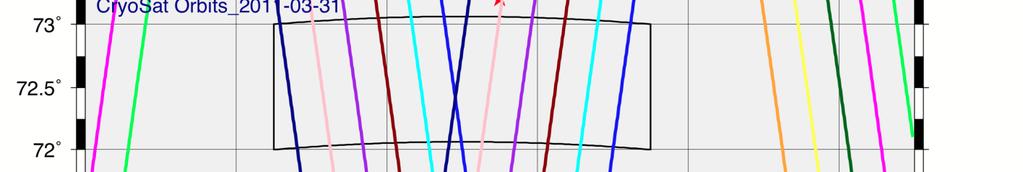
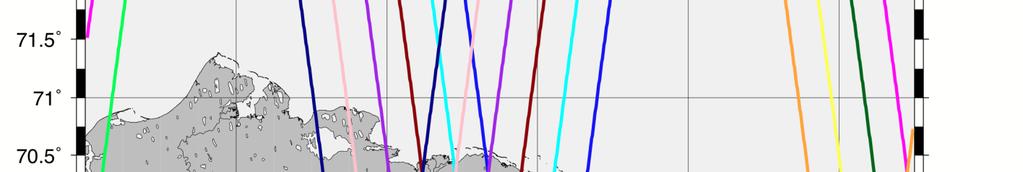


15 Cryosat2 Satellite Orbit Tracks


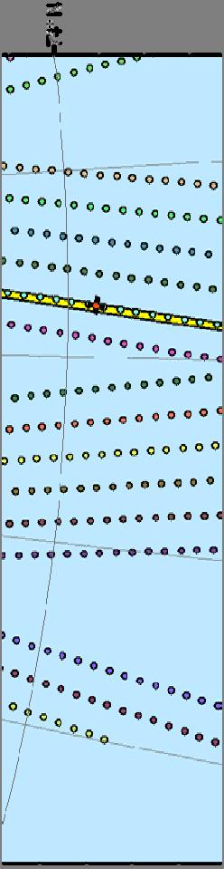


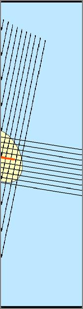
16 Up and Back Flight Along Satellite Track


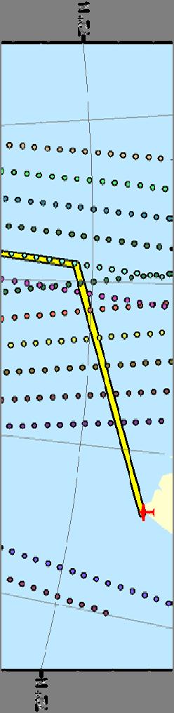
17 Notional Grid Flight Profile Over Ice Camp
Optimizing Observations of Sea Ice Thickness and Snow Depth in the Arctic
 DISTRIBUTION STATEMENT A. Approved for public release; distribution is unlimited. Optimizing Observations of Sea Ice Thickness and Snow Depth in the Arctic Jacqueline A. Richter-Menge CRREL, 72 Lyme Road,
Optimizing Observations of Sea Ice Thickness and Snow Depth in the Arctic
 DISTRIBUTION STATEMENT A. Approved for public release; distribution is unlimited. Optimizing Observations of Sea Ice Thickness and Snow Depth in the Arctic Sinead L. Farrell University of Maryland, ESSIC
Recent Improvements in the U.S. Navy s Ice Modeling Efforts Using CryoSat-2 Ice Thickness for Model Initialization
 Recent Improvements in the U.S. Navy s Ice Modeling Efforts Using CryoSat-2 Ice Thickness for Model Initialization Richard Allard 1, David Hebert 1, Pamela Posey 1, Alan Wallcraft 1, Li Li 2, William Johnston
In-situ and airborne sea ice observations for better sea ice prediction and climate analysis. Christian Haas
 In-situ and airborne sea ice observations for better sea ice prediction and climate analysis Christian Haas Data assimilation improves sea ice forecasts Most important parameters are: Concentration (SIC),
Sinéad Louise Farrell1,2,3 Thomas Newman1,2,, Alek Petty 1,2, Jackie Richter-Menge4, Dave McAdoo1,2, Larry Connor2
 Sinéad Louise Farrell1,2,3 Thomas Newman1,2,, Alek Petty 1,2, Jackie Richter-Menge4, Dave McAdoo1,2, Larry Connor2 1 Earth System Science Interdisciplinary Center, University of Maryland, USA 2 NOAA Laboratory
Mass balance of sea ice in both hemispheres Airborne validation and the AWI CryoSat-2 sea ice data product
 Mass balance of sea ice in both hemispheres Airborne validation and the AWI CryoSat-2 sea ice data product Stefan Hendricks Robert Ricker Veit Helm Sandra Schwegmann Christian Haas Andreas Herber Airborne
Sea Ice Observations: Where Would We Be Without the Arctic Observing Network? Jackie Richter-Menge ERDC-CRREL
 Sea Ice Observations: Where Would We Be Without the Arctic Observing Network? Jackie Richter-Menge ERDC-CRREL Sea Ice Observations: Where Would We Be Without the Arctic Observing Network? Jackie Richter-Menge
Observations of Arctic snow and sea ice thickness from satellite and airborne surveys. Nathan Kurtz NASA Goddard Space Flight Center
 Observations of Arctic snow and sea ice thickness from satellite and airborne surveys Nathan Kurtz NASA Goddard Space Flight Center Decline in Arctic sea ice thickness and volume Kwok et al. (2009) Submarine
Optimizing Observations of Sea Ice Thickness and Snow Depth in the Arctic
 DISTRIBUTION STATEMENT A. Approved for public release; distribution is unlimited. Optimizing Observations of Sea Ice Thickness and Snow Depth in the Arctic Jacqueline A. Richter-Menge CRREL, 72 Lyme Road
Welcome to PolarConnect. With Kelly McCarthy and NASA s Operation IceBridge
 Welcome to PolarConnect With Kelly McCarthy and NASA s Operation IceBridge 5 May 2016 If you are joining by phone, please mute your phone. Press *6 to mute and *6 to unmute. Participant Introductions In
Spectral Albedos. a: dry snow. b: wet new snow. c: melting old snow. a: cold MY ice. b: melting MY ice. d: frozen pond. c: melting FY white ice
 Spectral Albedos a: dry snow b: wet new snow a: cold MY ice c: melting old snow b: melting MY ice d: frozen pond c: melting FY white ice d: melting FY blue ice e: early MY pond e: ageing ponds Extinction
Remote sensing of sea ice
 Remote sensing of sea ice Ice concentration/extent Age/type Drift Melting Thickness Christian Haas Remote Sensing Methods Passive: senses shortwave (visible), thermal (infrared) or microwave radiation
Evaluating the Discrete Element Method as a Tool for Predicting the Seasonal Evolution of the MIZ
 DISTRIBUTION STATEMENT A. Approved for public release; distribution is unlimited. Evaluating the Discrete Element Method as a Tool for Predicting the Seasonal Evolution of the MIZ Arnold J. Song Cold Regions
Methods of Evaluating Arctic Sea-Ice Distribution and Thickness for Arctic Shipping
 Faculty of Engineering Science and Technology Department of Marine Technology Sustainable Arctic Sea Transport Group SAST ntnu.edu/sast Methods of Evaluating Arctic Sea-Ice Distribution and Thickness for
Merged sea-ice thickness product from complementary L-band and altimetry information
 Merged sea-ice thickness product from complementary L-band and altimetry information Contributors AWI Team Stefan Hendricks Robert Ricker Stephan Paul University Hamburg Team Lars Kaleschke Xiangshan Tian-Kunze
Sea Ice Growth And Decay. A Remote Sensing Perspective
 Sea Ice Growth And Decay A Remote Sensing Perspective Sea Ice Growth & Decay Add snow here Loss of Sea Ice in the Arctic Donald K. Perovich and Jacqueline A. Richter-Menge Annual Review of Marine Science
Using Remote-sensed Sea Ice Thickness, Extent and Speed Observations to Optimise a Sea Ice Model
 Using Remote-sensed Sea Ice Thickness, Extent and Speed Observations to Optimise a Sea Ice Model Paul Miller, Seymour Laxon, Daniel Feltham, Douglas Cresswell Centre for Polar Observation and Modelling
Product Validation Report Polar Ocean
 Product Validation Report Polar Ocean Lars Stenseng PVR, Version 1.0 July 24, 2014 Product Validation Report - Polar Ocean Lars Stenseng National Space Institute PVR, Version 1.0, Kgs. Lyngby, July 24,
Airborne sea ice thickness sounding
 Airborne sea ice thickness sounding 1, Christian Haas 2, Lasse Rabenstein 1, John Lobach 3 1. Alfred Wegener Institute for Polar and Marine Research, Germany 2. University of Alberta, Canada 3. Ferra Dynamics
SEA ICE OUTLOOK 2016 Report
 SEA ICE OUTLOOK 2016 Report Core Requirements for Pan-Arctic Contributions: * REQUIRED 1. *Name of Contributor or name of Contributing Organization and associated contributors as you would like your contribution
Arctic Cap Nowcast Forecast System (ACNFS) end of summer 2013 Ice Extent Projection July Report
 end of summer 2013 Ice Extent Projection July Report") Arctic Cap Nowcast Forecast System (ACNFS) end of summer 2013 Ice Extent Projection July Report Naval Research Laboratory, Stennis Space Center, MS The NRL Ice Team consists of: Pamela Posey 1, E. Joseph
Arctic Cap Nowcast Forecast System (ACNFS) end of summer 2013 Ice Extent Projection July Report Naval Research Laboratory, Stennis Space Center, MS The NRL Ice Team consists of: Pamela Posey 1, E. Joseph
An Assessment of the Navy's Sea Ice Outlook Predictions for 2014
 An Assessment of the Navy's Sea Ice Outlook Predictions for 2014 Pam Posey 1, Rick Allard 1, David Hebert 1, Joe Metzger 1, Ruth Preller 1, Alan Wallcraft 1, Ole Martin Smedstad 2, Michael Phelps 3 and
CryoSat: ESA s Ice Mission:
 CryoSat: ESA s Ice Mission: 6 years in operations: status and achievements T. Parrinello CryoSat Mission Manager M. Drinkwater Mission Scientist CryoSat March 2016 sea-ice thickness CryoSat: A bit of history
Loan 867. Calibration and validation of the CryoSat radar altimeter: field studies on the Greenland Ice Sheet.
 Loan 867. Calibration and validation of the CryoSat radar altimeter: field studies on the Greenland Ice Sheet. Elizabeth M. MORRIS Scott Polar Research Institute, Lensfield Road, Cambridge CB2 1ER, UK.
Arctic Regional Ocean Observing System Arctic ROOS Report from 2012
 Arctic Regional Ocean Observing System Arctic ROOS Report from 2012 By Stein Sandven Nansen Environmental and Remote Sensing Center (www.arctic-roos.org) Focus in 2012 1. Arctic Marine Forecasting Center
HY-2A Satellite User s Guide
 National Satellite Ocean Application Service 2013-5-16 Document Change Record Revision Date Changed Pages/Paragraphs Edit Description i Contents 1 Introduction to HY-2 Satellite... 1 2 HY-2 satellite data
Arctic sea ice thickness, volume, and multiyear ice coverage: losses and coupled variability ( )
") Environmental Research Letters LETTER OPEN ACCESS Arctic sea ice thickness, volume, and multiyear ice coverage: losses and coupled variability (1958 2018) To cite this article: R Kwok 2018 Environ. Res.
Environmental Research Letters LETTER OPEN ACCESS Arctic sea ice thickness, volume, and multiyear ice coverage: losses and coupled variability (1958 2018) To cite this article: R Kwok 2018 Environ. Res.
Geomorphologic Mapping by Airborne Laser Scanning in Southern Victoria Land
 Geomorphologic Mapping by Airborne Laser Scanning in Southern Victoria Land Bea Csatho, Terry Wilson, Tony Schenk, Garry McKenzie, Byrd Polar Research Center, The Ohio State University, Columbus, OH William
Assessment of Contemporary Satellite Sea Ice Thickness Products for Arctic Sea Ice
 Assessment of Contemporary Satellite Sea Ice Thickness Products for Arctic Sea Ice Heidi Sallila 1, Joshua McCurry 2,3, Sinéad Louise Farrell 2,3 and Eero Rinne 1 1 Finnish Meteorological Institute, Helsinki,
Airborne Measurement of Snow Thickness Over Sea Ice
 Airborne Measurement of Snow Thickness Over Sea Ice Uniquiea B. Wade Elizabeth City State University Elizabeth City, North Carolina 27909 Abstract Snow cover on sea ice plays an important role in the climate
Office of Naval Research Update and Status of Arctic Environmental Programs
 Office of Naval Research Update and Status of Arctic Environmental Programs October 2017 CDR Blake McBride Deputy, Ocean, Atmosphere and Space Research Division Office of Naval Research marvin.mcbride@navy.mil
Appendix E: Oceanographic Databases
 Appendix E: Oceanographic Databases Many of the principal U.S. and international database depositories for worldwide ocean observations are listed below, as are a few technical reports with descriptions
Observing Arctic Sea Ice Change. Christian Haas
 Observing Arctic Sea Ice Change Christian Haas Decreasing Arctic sea ice extent in September Ice extent is decreasing, but regional patterns are very different every year The Cryosphere Today, http://arctic.atmos.uiuc.edu;
The ICESat 2 Mission Laser altimetry of ice, clouds and land elevation
 OSTM SWT San Diego October 2011 The ICESat 2 Mission Laser altimetry of ice, clouds and land elevation and also ocean, coastal, and continental waters Charon Birkett, ESSIC/UMD on behalf of T. Markus,
Monitoring Sea Ice with Space-borne Synthetic Aperture Radar
 Monitoring Sea Ice with Space-borne Synthetic Aperture Radar Torbjørn Eltoft UiT- the Arctic University of Norway CIRFA A Centre for Research-based Innovation cirfa.uit.no Sea ice & climate Some basic
Buoy deployment by the ice breaker USCG Healy
 Enhancements of the Arctic Buoys for the International Polar Year Buoy deployment by the ice breaker USCG Healy Buoys-on-Ice 2007 a success: Deployment flights 26 and 29 March o Flying hours funded by
Airborne Remote Sensing for Ocean and Coastal Applications
 Airborne Remote Sensing for Ocean and Coastal Applications Ben Reineman, Luc Lenain, Nick Statom, David Castel, Ken Melville Scripps Institution of Oceanography 17 October, 2011 Address for correspondence:
The US Navy s Current and Future Sea Ice Forecast Capabilities
 The US Navy s Current and Future Sea Ice Forecast Capabilities Pamela G. Posey, E. Joseph Metzger, Alan J. Wallcraft, Richard A. Allard, David A. Hebert, Ole Martin Smedstad, Julia Crout and Michael Phelps
Research Interests: variability of sea ice thickness interactions among ocean, seaice and atmosphere climate modelling
 Dr. Richard Moritz Department Chair, Polar Science Center M.S. (Yale University, 1979), M.A. (University of Colorado, 1979), PhD (Yale University, 1988) Research Interests: variability of sea ice thickness
AIRBORNE EM SEA-ICE THICHNESS PROFILING OVER BRACKISH BALTIC SEA WATER
 17th International Symposium on Ice Saint Petersburg, Russia, 21-25 June 2004 International Association of Hydraulic Engineering and Research AIRBORNE EM SEA-ICE THICHNESS PROFILING OVER BRACKISH BALTIC
How thick can Baltic sea ice get? Mikko Lensu Finnish Meteorological Institute
 How thick can Baltic sea ice get? Mikko Lensu Finnish Meteorological Institute In the Baltic ice research is closely related to winter navigation there are about 25 000 port calls to Finnish ports during
The Properties of Convective Clouds Over the Western Pacific and Their Relationship to the Environment of Tropical Cyclones
 The Properties of Convective Clouds Over the Western Pacific and Their Relationship to the Environment of Tropical Cyclones Principal Investigator: Dr. Zhaoxia Pu Department of Meteorology, University
Seasonal forecasts of Arctic sea ice initialized with observations of ice thickness
 GEOPHYSICAL RESEARCH LETTERS, VOL. 39,, doi:10.1029/2012gl053576, 2012 Seasonal forecasts of Arctic sea ice initialized with observations of ice thickness R. Lindsay, 1 C. Haas, 2 S. Hendricks, 3 P. Hunkeler,
High-resolution airborne observations of sea-ice pressure ridge sail height
 Annals of Glaciology 59(76pt2) 2018 doi: 10.1017/aog.2018.2 137 The Author(s) 2018. This is an Open Access article, distributed under the terms of the Creative Commons Attribution-NonCommercial-NoDerivatives
Arctic Ocean Mean Sea Surface, Geoid and Gravity from Surface Data, Icesat and GRACE a reference for Cryosat sea-ice mapping
 Arctic Ocean Mean Sea Surface, Geoid and Gravity from Surface Data, Icesat and GRACE a reference for Cryosat sea-ice mapping R. Forsberg and H. Skourup, Geodynamics Dept., DNSC rf@spacecenter.dk Arctic
SMOSIce L-Band Radiometry for Sea Ice Applications
 Institute of Environmental Physics University of Bremen SMOSIce L-Band Radiometry for Sea Ice Applications Georg Heygster 1), Christian Haas 2), Lars Kaleschke 3), Helge Rebhan 5), Detlef Stammer 3), Rasmus
METOC at Defence Center for Operational Oceanography (FCOO)
") METOC at Defence Center for Operational Oceanography (FCOO) Forsvarets Center for Operativ Oceanografi Dr. Johan Söderqvist Oceanographer jos@fcoo.dk FCOO Staff (13 pos.) Geophysical expertise: oceanography,
METOC at Defence Center for Operational Oceanography (FCOO) Forsvarets Center for Operativ Oceanografi Dr. Johan Söderqvist Oceanographer jos@fcoo.dk FCOO Staff (13 pos.) Geophysical expertise: oceanography,
Sea Ice Prediction Network (SIPN) Webinar: Industry Needs for Seasonal and Sub-seasonal Sea Ice Information and Predictions
 Webinar: Industry Needs for Seasonal and Sub-seasonal Sea Ice Information and Predictions") Sea Ice Prediction Network (SIPN) Webinar: Industry Needs for Seasonal and Sub-seasonal Sea Ice Information and Predictions Hajo Eicken International Arctic Research Center University of Alaska Fairbanks,
Sea Ice Prediction Network (SIPN) Webinar: Industry Needs for Seasonal and Sub-seasonal Sea Ice Information and Predictions Hajo Eicken International Arctic Research Center University of Alaska Fairbanks,
Geoid and MDT of the Arctic Ocean
 Geoid and MDT of the Arctic Ocean Rene Forsberg, Henriette Skourup Geodynamics Dept National Space Institute Techical University of Denmark rf@space.dtu.dk Outline: Determination of MDT from remote sensing
An account of fieldwork in the Arctic Ocean
 An account of fieldwork in the Arctic Ocean Katharine Giles Centre for Polar Observation and Modelling, University College London 2007 marked the start of the 4th International Polar Year (IPY 2007 2008),
SEA ICE PREDICTION NETWORK (SIPN) Pan-Arctic Sea Ice Outlook Core Contributions July 2015 Report
 Pan-Arctic Sea Ice Outlook Core Contributions July 2015 Report") 1. Contributor Name(s)/Group SEA ICE PREDICTION NETWORK (SIPN) Pan-Arctic Sea Ice Outlook Core Contributions July 2015 Report Naval Research Laboratory (NRL), Stennis Space Center, MS The NRL Sea Ice Team
1. Contributor Name(s)/Group SEA ICE PREDICTION NETWORK (SIPN) Pan-Arctic Sea Ice Outlook Core Contributions July 2015 Report Naval Research Laboratory (NRL), Stennis Space Center, MS The NRL Sea Ice Team
The Seasonal Evolution of Sea Ice Floe Size Distribution
 DISTRIBUTION STATEMENT A. Approved for public release; distribution is unlimited. The Seasonal Evolution of Sea Ice Floe Size Distribution Jacqueline A. Richter-Menge and Donald K. Perovich CRREL, 72 Lyme
This is version v0.2 of this report issued together with the SIT and SIV data sets at the ICDC ESA-CCI- Projekt web page
 Report about Retrieval of sea-ice volume (SIV) from SICCI-2 sea-ice thickness (SIT) data and combined OSI-450 and SICCI-2 sea-ice concentration (SIC) data version v0.2, June 2018 by Stefan Kern, ICDC,
EUMETSAT STATUS AND PLANS
 1 EUM/TSS/VWG/15/826793 07/10/2015 EUMETSAT STATUS AND PLANS François Montagner, Marine Applications Manager, EUMETSAT WMO Polar Space Task Group 5 5-7 October 2015, DLR, Oberpfaffenhofen PSTG Strategic
MOSAiC Science Implementation The Multidisciplinary drifting Observatory for the Study of Arctic Climate
 MOSAiC Science Implementation The Multidisciplinary drifting Observatory for the Study of Arctic Climate MOSAiC Coordination Team M. Shupe. 13 March 2016 MOSAiC Plan Drifting, interdisciplinary process
EM ice thickness measurements during GreenICE 2004 field campaign
 EM ice thickness measurements during GreenICE field campaign Latitude ( N).... Ice thickness (m).. Longitude ( E) GreenICE Deliverable D Christian Haas October Executive summary This report summarizes
Some NOAA Products that Address PSTG Satellite Observing Requirements. Jeff Key NOAA/NESDIS Madison, Wisconsin USA
 Some NOAA Products that Address PSTG Satellite Observing Requirements Jeff Key NOAA/NESDIS Madison, Wisconsin USA WMO Polar Space Task Group, 4 th meeting, Greenbelt, 30 September 2014 Relevant Missions
Dual-Frequency Ku- Band Radar Mission Concept for Snow Mass
 Dual-Frequency Ku- Band Radar Mission Concept for Snow Mass Chris Derksen Environment and Climate Change Canada Study Team: Climate Research Division/Meteorological Research Division, ECCC Canadian Space
Objectives for meeting
 Objectives for meeting 1) Summarize planned experiments 2) Discuss resource availability Aircraft Instrumentation Expendables 3) Assign working groups to complete each experiment plan Flight planning and
SMAP Winds. Hurricane Irma Sep 5, AMS 33rd Conference on Hurricanes and Tropical Meteorology Ponte Vedra, Florida, 4/16 4/20, 2018
 Intensity and Size of Strong Tropical Cyclones in 2017 from NASA's SMAP L-Band Radiometer Thomas Meissner, Lucrezia Ricciardulli, Frank Wentz, Remote Sensing Systems, Santa Rosa, USA Charles Sampson, Naval
A two-season impact study of the Navy s WindSat surface wind retrievals in the NCEP global data assimilation system
 A two-season impact study of the Navy s WindSat surface wind retrievals in the NCEP global data assimilation system Li Bi James Jung John Le Marshall 16 April 2008 Outline WindSat overview and working
SCICEX Phase 2 Accommodation Cruises. Provided by T. Boyd
 SCICEX Phase 2 Accommodation Cruises Provided by T. Boyd OBJECTIVES Re-invigorate the SCICEX Science Advisory Committee Maximize the contribution of SCICEX in understanding di the Arctic Ocean processes
Ku-band radar penetration into snow cover on Arctic sea ice using airborne data
 Annals of Glaciology 52(57) 2011 197 Ku-band radar penetration into snow cover on Arctic sea ice using airborne data Rosemary WILLATT, 1 Seymour LAXON, 1 Katharine GILES, 1 Robert CULLEN, 2 Christian HAAS,
Floating Ice: Progress in Addressing Science Goals
 Polar Floating Ice: Progress in Addressing Science Goals Stephen Howell 1, Leif Toudal Pedersen 2 and Roberto Saldo 3 1 Environment Canada, Climate Research Division, Toronto, Canada 2 Danish Meteorological
Snow on sea ice retrieval using microwave radiometer data. Rasmus Tonboe and Lise Kilic Danish Meteorological Institute Observatoire de Paris
 Snow on sea ice retrieval using microwave radiometer data Rasmus Tonboe and Lise Kilic Danish Meteorological Institute Observatoire de Paris We know something about snow The temperature gradient within
High-Resolution Satellite-Derived Ocean Surface Winds in the Nordic-Barents Seas Region in : Implications for Ocean Modeling
 High-Resolution Satellite-Derived Ocean Surface Winds in the Nordic-Barents Seas Region in 2007-2008: Implications for Ocean Modeling Векторные поля приповерхностных скоростей ветра над Cеверным и Баренцевым
Remote sensing with FAAM to evaluate model performance
 Remote sensing with FAAM to evaluate model performance YOPP-UK Workshop Chawn Harlow, Exeter 10 November 2015 Contents This presentation covers the following areas Introduce myself Focus of radiation research
TECH NOTE. New Mean Sea Surface for the CryoSat-2 L2 SAR Chain. Andy Ridout, CPOM, University College London
 TECH NOTE Subject : From : To : New Mean Sea Surface for the CryoSat-2 L2 SAR Chain Andy Ridout, CPOM, University College London Tommaso Parrinello, CryoSat Mission Manager, ESRIN Date : 30 th June 2014
Concurrent simulation of the eddying general circulation and tides in a global ocean model
 Concurrent simulation of the eddying general circulation and tides in a global ocean model Brian K. Arbic 1 E. Joseph Metzger 2 Alan J. Wallcraft 2 1 Department of Oceanography and Center for Ocean-Atmospheric
P. Cipollini, H. Snaith - A short course on Altimetry. Altimetry 2 - Data processing (from satellite height to sea surface height)
") P. Cipollini, H. Snaith - A short course on Altimetry Altimetry 2 - Data processing (from satellite height to sea surface height) 1 2 Satellite height to sea surface height The altimeter measures the altitude
P. Cipollini, H. Snaith - A short course on Altimetry Altimetry 2 - Data processing (from satellite height to sea surface height) 1 2 Satellite height to sea surface height The altimeter measures the altitude
The Seasonal Evolution of Sea Ice Floe Size Distribution
 DISTRIBUTION STATEMENT A. Approved for public release; distribution is unlimited. The Seasonal Evolution of Sea Ice Floe Size Distribution Jacqueline A. Richter-Menge and Donald K. Perovich CRREL 72 Lyme
VIDEO/LASER HELICOPTER SENSOR TO COLLECT PACK ICE PROPERTIES FOR VALIDATION OF RADARSAT SAR BACKSCATTER VALUES
 VIDEO/LASER HELICOPTER SENSOR TO COLLECT PACK ICE PROPERTIES FOR VALIDATION OF RADARSAT SAR BACKSCATTER VALUES S.J. Prinsenberg 1, I.K. Peterson 1 and L. Lalumiere 2 1 Bedford Institute of Oceanography,
Small-scale horizontal variability of snow, sea-ice thickness and freeboard in the first-year ice region north of Svalbard
 Annals of Glaciology 54(62) 2013 doi:10.3189/2013aog62a157 261 Small-scale horizontal variability of snow, sea-ice thickness and freeboard in the first-year ice region north of Svalbard Jari HAAPALA, 1
Aircraft Observations for ONR DRI and DYNAMO. Coupled Air-sea processes: Q. Wang, D. Khelif, L. Mahrt, S. Chen
 Aircraft Observations for ONR DRI and DYNAMO (NOAA/ONR/NSF) Coupled Air-sea processes: Q. Wang, D. Khelif, L. Mahrt, S. Chen Deep convection/mjo initiation: Dave Jorgensen, S. Chen, R. Houze Aerosol/Cloud
Measuring Ice Like NASA Does!
 Details Arctic / Antarctic About 1 Period Download, share, and remix Middle School and Up Measuring Ice Like NASA Does! Overview One of the most important indicators of our warming climate is the extent
Notes for Remote Sensing: Glacier Elevation, Volume and Mass Change
 Notes for Remote Sensing: Glacier Elevation, Volume and Mass Change Elevation and Volume Change: Alex S Gardner Atmospheric Oceanic and Space Sciences, University of Michigan Aircraft- and satellite- mounted
Sea ice thickness. Ed Blanchard-Wrigglesworth University of Washington
 Sea ice thickness Ed Blanchard-Wrigglesworth University of Washington Sea ice thickness Ed Blanchard-Wrigglesworth University of Washington Part II: variability Sea ice thickness Ed Blanchard-Wrigglesworth
Arctic Observing Systems Challenges, New opportunities and Integration
 Arctic Observing Systems Challenges, New opportunities and Integration Japan Norway Arctic Science Week 03 June 2016 By Stein Sandven, NERSC Building an integrated Arctic Observing System Need to collect,
Precipitation, snow accumulation and sea ice thickness over the Arctic Ocean
 Precipitation, snow accumulation and sea ice thickness over the Arctic Ocean Alek Petty, Linette Boisvert, Melinda Webster, Thorsten Markus, Nathan Kurtz, Jeremy Harbeck www.alekpetty.com / @alekpetty
Observing Snow: Conventional Measurements, Satellite and Airborne Remote Sensing. Chris Derksen Climate Research Division, ECCC
 Observing Snow: Conventional Measurements, Satellite and Airborne Remote Sensing Chris Derksen Climate Research Division, ECCC Outline Three Snow Lectures: 1. Why you should care about snow 2. How we measure
Knowledge-based sea ice classification by polarimetric SAR
 Downloaded from orbit.dtu.dk on: Dec 17, 217 Knowledge-based sea ice classification by polarimetric SAR Skriver, Henning; Dierking, Wolfgang Published in: IEEE International Geoscience Remote Sensing Symposium,
The Arctic Sea Ice Cover
 The Arctic Sea Ice Cover From the Living Earth Interface, Impediment, Integrator Frozen ocean 8-15 million km 2 Size of U.S. Meters thick Floating, moving ice Highly variable Large albedo Climate change!
Applying High Resolution Imagery to Understand the Role of Dynamics in the Diminishing Arctic Sea Ice Cover
 DISTRIBUTION STATEMENT A. Approved for public release; distribution is unlimited. Applying High Resolution Imagery to Understand the Role of Dynamics in the Diminishing Arctic Sea Ice Cover Dr. Sinead
Derivation of Ice Thickness and Age for Use with GOES-R ABI Data
 GOES-R AWG Cryosphere Team Derivation of Ice Thickness and Age for Use with GOES-R ABI Data Presented by: Xuanji Wang 1 Other team members: Jeff Key 2, Yinghui Liu 1 1 UW-Madison/CIMSS 2 NOAA/NESDIS/STAR
Steven Greco* and George D. Emmitt Simpson Weather Associates, Charlottesville, VA. 2. Experiments
 3.3 INVESTIGATION OF FLOWS WITHIN COMPLEX TERRAIN AND ALONG COASTLINES USING AN AIRBORNE DOPPLER WIND LIDAR: OBSERVATIONS AND MODEL COMPARISONS Steven Greco* and George D. Emmitt Simpson Weather Associates,
Regional Outlook for the Bering-Chukchi-Beaufort Seas Contribution to the 2018 Sea Ice Outlook
 Regional Outlook for the Bering-Chukchi-Beaufort Seas Contribution to the 2018 Sea Ice Outlook 25 July 2018 Matthew Druckenmiller (National Snow and Ice Data Center, Univ. Colorado Boulder) & Hajo Eicken
JALBTCX AND THE USACE NATIONAL COASTAL MAPPING PROGRAM
 JALBTCX AND THE USACE NATIONAL COASTAL MAPPING PROGRAM 237 237 237 217 217 217 200 200 200 80 119 27 252 174.59 1 255 255 255 0 0 0 163 163 163 131 132 122 239 65 53 110 135 120 112 92 56 62 102 130 102
Coupling of Waves, Turbulence and Thermodynamics across the Marginal Ice Zone
 DISTRIBUTION STATEMENT A. Approved for public release; distribution is unlimited. Coupling of Waves, Turbulence and Thermodynamics across the Marginal Ice Zone Tim Stanton and Bill Shaw Oceanography Department,
Earth Exploration-Satellite Service (EESS)- Active Spaceborne Remote Sensing and Operations
- Active Spaceborne Remote Sensing and Operations") Earth Exploration-Satellite Service (EESS)- Active Spaceborne Remote Sensing and Operations SRTM Radarsat JASON Seawinds TRMM Cloudsat Bryan Huneycutt (USA) Charles Wende (USA) WMO, Geneva, Switzerland
Earth Exploration-Satellite Service (EESS)- Active Spaceborne Remote Sensing and Operations SRTM Radarsat JASON Seawinds TRMM Cloudsat Bryan Huneycutt (USA) Charles Wende (USA) WMO, Geneva, Switzerland
Glacier Elevation, Volume and Mass Change
 8/8/12 Glacier Elevation, Volume and Mass Change 1 Outline: Elevation, Volume and Mass Change ① Elevation change fundamentals ② Elevation measurement platforms ③ Calculating elevation change ④ Calculating
High resolution ground-based snow measurements during the NASA CLPX-II campaign, North Slope, Alaska
 High resolution ground-based snow measurements during the NASA CLPX-II campaign, North Slope, Alaska H.P. Marshall1, N. Rutter2, K. Tape3, M. Sturm4, R. Essery5 1 Boise State University, Department of
PIPS 3.0. Pamela G. Posey NRL Code 7322 Stennis Space Center, MS Phone: Fax:
 PIPS 3.0 Ruth H. Preller Naval Research Laboratory, Code 7322 Stennis Space Center, MS 39529 phone: (228) 688-5444 fax: (228)688-4759 email: preller@nrlssc.navy.mil Pamela G. Posey NRL Code 7322 Stennis
HYCOM Caspian Sea Modeling. Part I: An Overview of the Model and Coastal Upwelling. Naval Research Laboratory, Stennis Space Center, USA
 HYCOM Caspian Sea Modeling. Part I: An Overview of the Model and Coastal Upwelling By BIROL KARA, ALAN WALLCRAFT AND JOE METZGER Naval Research Laboratory, Stennis Space Center, USA MURAT GUNDUZ Institute
CryoSat Monthly Quality Report #93
 9th May 2018-7th June 2018 Author(s): CryoSat Quality Control Team (Telespazio UK) IDEAS+-VEG-OQC-REP-2987 17 July 2018 AMENDMENT RECORD SHEET The Amendment Record Sheet below records the history and issue
Improved EM Tactical Applications through UAS-Enhanced High-Resolution Mesoscale Data Assimilation and Modeling
 DISTRIBUTION STATEMENT A. Approved for public release; distribution is unlimited. Improved EM Tactical Applications through UAS-Enhanced High-Resolution Mesoscale Data Assimilation and Modeling Teddy R.
Three years of sea ice freeboard, snow depth, and ice thickness of the Weddell Sea from Operation IceBridge and CryoSat-2
 Three years of sea ice freeboard, snow depth, and ice thickness of the Weddell Sea from Operation IceBridge and CryoSat-2 Ron Kwok 1, Sahra Kacimi 1 1 Jet Propulsion Laboratory, California Institute of
ICE ENVIRONMENTAL DATA COLLECTION FOR THE NORTH CASPIAN SEA
 Ice in the Environment: Proceedings of the 16th IAHR International Symposium on Ice Dunedin, New Zealand, 2nd 6th December 2002 International Association of Hydraulic Engineering and Research ICE ENVIRONMENTAL
Anfang. German Arctic expeditions ASSW, March 27 April 1, 2011, Seoul, Korea. Foto: L. Tadday
 Anfang German Arctic expeditions 2010-2011 ASSW, March 27 April 1, 2011, Seoul, Korea Foto: L. Tadday Overview: Research facilities around the globe Arctic Science Summit Week, March 27 April 1, 2011,
New Salinity Product in the Tropical Indian Ocean Estimated from OLR
 New Salinity Product in the Tropical Indian Ocean Estimated from OLR Aquarius Bulusu Subrahmanyam and James J. O Brien Center for Ocean-Atmospheric Prediction Studies, Florida State University V.S.N. Murty
CryoVEx 2011 Alert Sea Ice Ground Team Report
 CryoVEx 2011 Alert Sea Ice Ground Team Report Ground Team Operating out of Alert base, April 11 th 18 th 2011: Christian Haas (PI) & Justin Beckers, University of Alberta; Seymour Laxon, Katharine Giles