K&C Phase 4 Status report. Ice Sheet Monitoring using ALOS-2. University of California, Irvine 2 JPL
|
|
|
- Roger Clarke
- 5 years ago
- Views:
Transcription
1 K&C Phase 4 Status report Ice Sheet Monitoring using ALOS-2 Bernd Scheuchl 1, Jeremie Mouginot 1, Eric Rignot 1,2 1 University of California, Irvine 2 JPL Science Team meeting #24 Tokyo, Japan, January 29-31, 2018

 needed to make")


")


2 Climate Change, International Conventions Motivation for this work Ice sheets are acknowledged by WMO and UNFCCC as Essential Climate Variable (ECV) needed to make significant progress in the generation of global climate products and derived information. The 2011 update for the GCOS Systematic observation requirements for satellite- based data products for climate specifically mentions the need to monitor the great ice sheets. Background As contribution to the International Polar Year (IPY, ) the Space Task Group coordinated large scale SAR data acquisitions in Antarctica and Greenland. The campaign was a spectacular success and the science community responded by producing continent wide ice velocity maps and related products. Current situation Post IPY: The Polar Space Task Group (PSTG) was established to succeed STG and build on the IPY success.

3 Global mean sea level will continue to rise during the 21st century. Under all RCP scenarios the rate of sea level rise will very likely exceed that observed during due to increased ocean warming and increased loss of mass from glaciers and ice sheets. IPCC IV Working Group I Contribution to the IPCC Fifth Assessment Report Climate Change 2013: The Physical Science Basis Summary for Policymakers

4 Key Question: Are the ice sheets loosing mass? Background Three independent methods are available to measure mass balance Shepherd et al. Science (47 authors)

5 Ice Sheet Acquisition Requirements - PSTG Key ice sheet science issues include: Surface elevation change (SEC) Ice velocity (IV) Grounding line location (GLL) Calving front location (CFL) Ice discharge SEC IV GLL CFL Minimum spatial resolution 1-5 km 100 m 1 km 100 m 1 km 100 m 500 m Optimum spatial resolution 100 m 50 m 50 m 50 m Minimum temporal resolution annual annual annual annual Optimum temporal resolution monthly monthly monthly monthly Minimum Accuracy m/yr 30m/yr 1 km 200 m Optimum Accuracy <0.1 m/yr 10 m/yr - - Observations needed All year All year All year All year

 * Weekly was added here to")


6 Frequency Ice Sheet Acquisition Requirements - PSTG Coverage weekly/m onthly * annual 3 years ** Continuous monitoring of Margins / Grounding Zone Ice sheet wide coverage GIS, AIS ** Antarctica Pole Hole filled (** in recognition of current fleet capabilities) * Weekly was added here to reflect the need for ongoing acquisitions using every available repeat. For missions with 1 day interval multiple 1 day repeats in the grounding zone of glaciers would be an asset. ** The 3 year in recognition of current fleet capabilities. More left looking capabilities are being brought online in the future.
7 Project outline and objectives The main objective of our project is to generate ice sheet relevant earth system data records (ESDR) based on ALOS-2. The basic observation plan for ALOS-2 includes systematic InSAR data acquisitions over the ice sheets in Antarctica and Greenland. We propose to utilize a portion of these BOS acquisitions to produce ice velocity and grounding line maps. A secondary objective of our project is the documentation of the impact of CO2-induced warming on glacier retreat. The ESDRs produced will contribute to a reduction of uncertainties related to the climate system. They will also be useful in developing strategies to prepare for the adverse impacts of climate change.
8 Project milestones & Data sharing For each year we envision the production of the aforementioned ESDRs. After year 3, we will also assemble time series products that will be published once the final year (year 4) data can be integrated. Finally, we plan to integrate the ALOS based ESDRs with ESDRs from other spaceborne SAR data to achieve an ice sheet wide, post IPY reference map. We will publish our findings in the scientific literature. We do not collect ground truth data for this project but we will share with JAXA all ice sheet ESDRs that were generated using data from multiple SAR satellites
9 Deliverables Annual ice velocity maps over selected regions in Antarctica and Greenland Grounding line maps for selected regions in Antarctica where data proves suitable to generate this information (delivery at project end) Ice front maps for selected ice shelves and glaciers in Antarctica and Greenland Publications
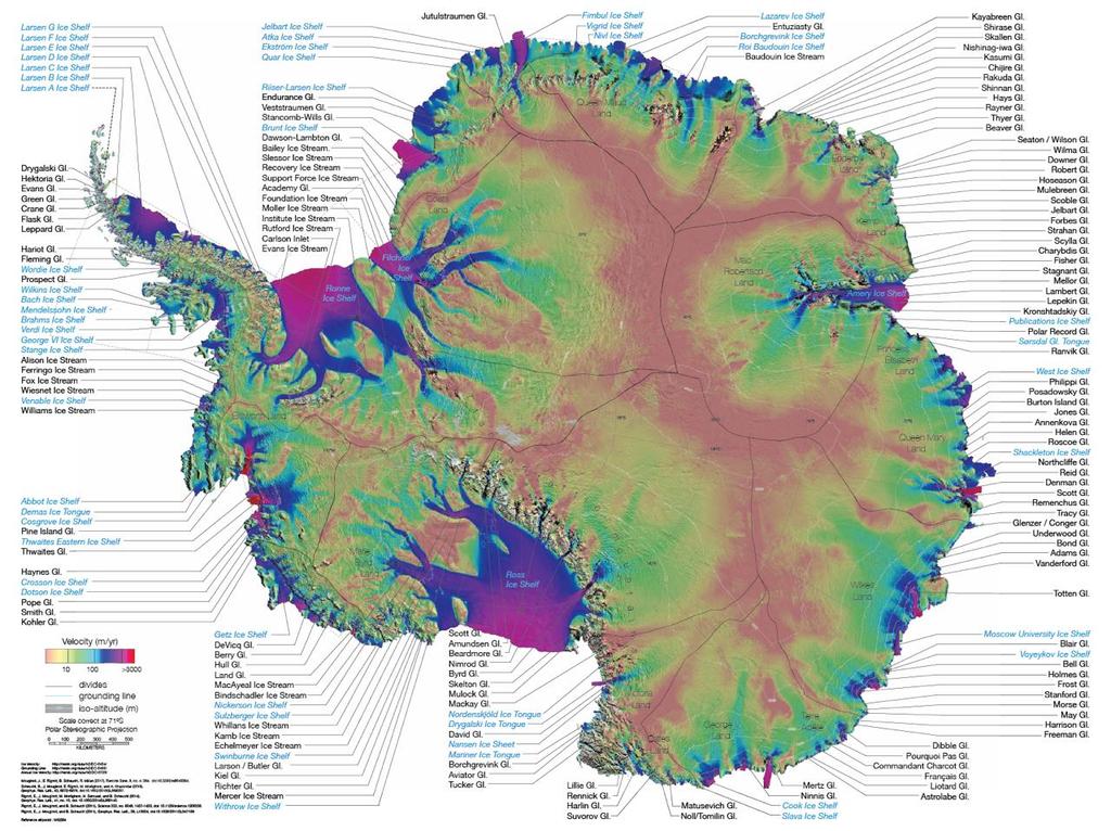
10 MEaSUREs Antarctica MEaSUREs Annual Antarctic Ice Velocity Maps , V1 MEaSUREs Antarctic Boundaries for IPY from Satellite Radar, V2 MEaSUREs InSAR-Based Antarctica Ice Velocity Map, V2 MEaSUREs Antarctic Grounding Line from Differential Satellite Radar Interferometry, V2 MEaSUREs InSAR-Based Ice Velocity of the Amundsen Sea Embayment, Antarctica, V1 MEaSUREs InSAR-Based Ice Velocity Maps of Central Antarctica: 1997 and 2009, V1

11 Antarctic Grounding Line Product MEaSUREs Antarctic Grounding Line from Differential Satellite Radar Interferometry, V 2 Link Funding Program: NASA MEaSUREs Data Sources: ERS-1, ERS-2, RADARSAT-1, RADARSAT-2, ENVISAT ASAR, ALOS PALSAR, Copernicus SENTINEL-1, and Cosmo-Skymed The WMO Polar Space Task Group is gratefully acknowledged for its role in coordinating data acquisition plans. Rignot et al 2011 Rignot et al Li et al Scheuchl et al Milillo et al 2017
12 Antarctic Boundaries Product MEaSUREs Antarctic Boundaries for IPY from Satellite Radar, Version 2 Link Funding Program: NASA MEaSUREs Data Sources: ERS-1, ERS-2, RADARSAT-1, RADARSAT-2, ENVISAT ASAR, ALOS PALSAR, Copernicus SENTINEL-1, and Cosmo-Skymed The WMO Polar Space Task Group is gratefully acknowledged for its role in coordinating data acquisition plans. Rignot, E., S. S. Jacobs, J. Mouginot, and B. Scheuchl Ice-shelf melting around Antarctica, Science Improved flow direction in slow moving areas is the basis for improved glacier basins, which are crucial for mass balance studies IMBIE-2 basins + a refined version Ice shelf mask (IPY, Rignot et al. 2013) Coast line and grounding line (continuous product based on InSAR GL and other available products)
13 Continent-Wide Ice Velocity Map Product MEaSUREs InSAR-Based Antarctica Ice Velocity Map V2. Link Funding Program: NASA MEaSUREs Data Sources: ERS-1, ERS-2, RADARSAT-1, RADARSAT-2, ENVISAT ASAR, ALOS PALSAR, ALOS-2 PALSAR-2, Copernicus SENTINEL-1, LANDSAT-8 The WMO Polar Space Task Group is gratefully acknowledged for its role in coordinating data acquisition plans. Mouginot, J., Rignot, E., Scheuchl, B., Millan, R Comprehensive Annual Ice Sheet Velocity Mapping Using Landsat-8, Sentinel-1, and RADARSAT-2 Data. Remote Sensing 9(4): Art. #364. doi:

14 Annual Ice Velocity Maps Product MEaSUREs Annual Ice Velocity Maps of Antarctica. Link Funding Program: NASA MEaSUREs Data Sources: ERS-1, ERS-2, RADARSAT-1, RADARSAT-2, ENVISAT ASAR, ALOS PALSAR, ALOS-2 PALSAR-2, Copernicus SENTINEL-1, LANDSAT-8 The WMO Polar Space Task Group is gratefully acknowledged for its role in coordinating data acquisition plans. Mouginot, J., Rignot, E., Scheuchl, B., Millan, R Comprehensive Annual Ice Sheet Velocity Mapping Using Landsat-8, Sentinel-1, and RADARSAT-2 Data. Remote Sensing 9(4): Art. #364. doi:
15

")


16 Flow Direction Speed (km/yr) < >3 Speckle Tracking InSAR Phase
 and with")
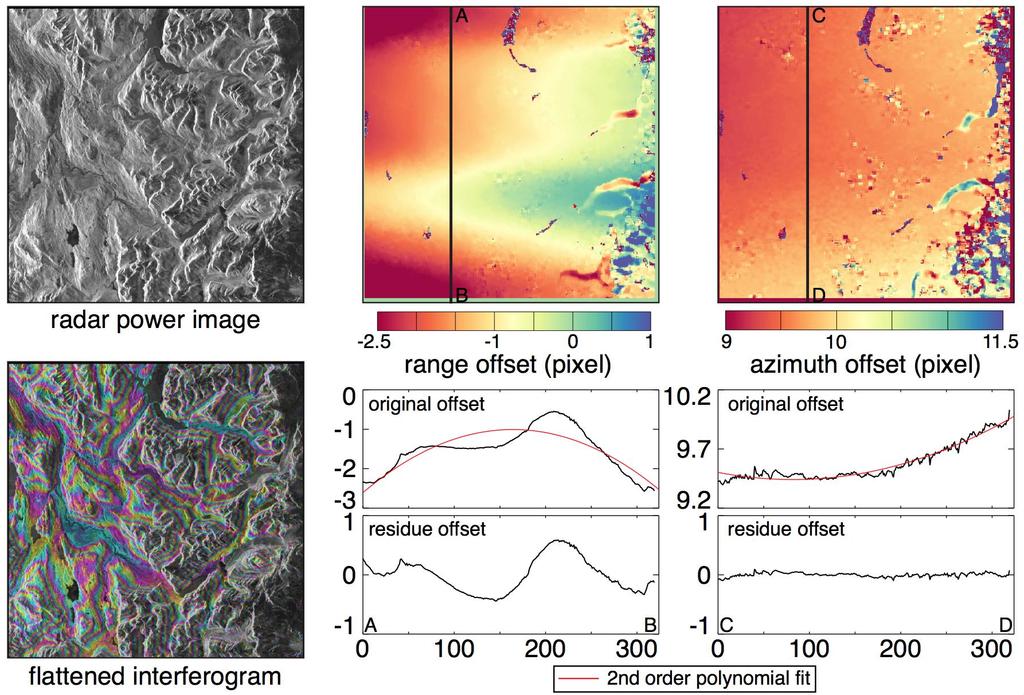
17 Ionosphere correction Collaboration with Heming Liao and Franz Meyer, University of Alaska. Liao, H., Meyer, F., Scheuchl, B., Mouginot, J., Rignot, E., Joughin, I. (in revision). Ionospheric Correction of InSAR Data for Accurate Ice Velocity Measurement at Polar Regions Antarctic time series slant range ice velocity measurements profile analysis without (top) and with ionospheric correction (bottom). Shown in gray is the tracking-based reference ice velocity from MEaSUREs (Mouginot et al., 2012, 2017; Rignot et al., 2011).
18 Ionosphere correction Collaboration with Heming Liao and Franz Meyer, University of Alaska. Liao, H., Meyer, F., Scheuchl, B., Mouginot, J., Rignot, E., Joughin, I. (in revision). Ionospheric Correction of InSAR Data for Accurate Ice Velocity Measurement at Polar Regions Average ice velocity of non-ionosphere-corrected measurements and its standard error (red line and shading) vs. the ionosphere-corrected ice velocity and its standard error (blue line and shading). Shown in gray is the trackingbased reference ice velocity from MEaSUREs.
")
")
19 > 3800 unwrapped phases ESA CSA ENVISAT/ASAR (627) RADARSAT (1063) JAXA ESA ALOS/PALSAR (2014) ERS1996 (164)
20
 Phase (parallel flow)")
21 Speed (m/yr) Balance Velocity Modeled result (M. Morlighem) < >300 Image corr. (parallel flow) Phase (parallel flow)

22 Canadian High Arctic Research Station (CHARS) 2018 Multi-frequency, polarimetric, scatterometer measurements of sea ice Goal: collect time series polarimetric L- and C-band backscatter data for first-year and multiyear sea ice types from winter to summer. Sea ice is landfast, enabling fundamental studies of seasonal signature evolution without need for ice tracking. Data: April (winter): airborne survey of first-year and multiyear ice thickness and roughness by EM-induction and laser scanner (baseline conditions). April to June (winter to summer): In situ collection of polarimetric L- and C-band scatterometer and ice geophysical property data. Coincident ALOS-2 and RADARSAT-2 SAR data. Polarimetric RADARSAT-2 data provided by government of Canada.
 5.55 1.26 Bandwidth (GHz) 0.5 0.5 Antenna beam-width ( ) 5.")
 30 30 Sampling footprint 0.4m at 17 to 2.6m at 81 15-80 (programmable) 1.")
23 Canadian High Arctic Research Station (CHARS) 2018 Multi-frequency, polarimetric, scatterometer measurements of sea ice L-band Specification C-band L-band C-band Centre frequency (GHz) Bandwidth (GHz) Antenna beam-width ( ) Polarizations Fully-polarimetric (VV, HH, HV, VH) Noise floor (dbm 2 ) Incidence angle range (increments) ( ) (2) Antenna height (m) Range resolution (cm) Sampling footprint 0.4m at 17 to 2.6m at (programmable) 1.2m to ranges of 6m (1/2 far field distance) First deployment of L-band scatterometer designed for low temperature environment on sea ice adjacent to CHARS.

, Ice thickness in the Northwest Passage, Geophys. Res. Lett., 42, 7673 7680, doi:10.")
24 Canadian High Arctic Research Station (CHARS) 2018 Multi-frequency, polarimetric, scatterometer measurements of sea ice Victoria Strait and M Clintock Channel regions have been studied extensively since Data collection has included Full Polarimetry RADARSAT-2 but limited Full Polarimetry ALOS-2 to date. Haas, C., and S. E. L. Howell (2015), Ice thickness in the Northwest Passage, Geophys. Res. Lett., 42, , doi: /2015gl
25 Conclusions Ice Sheets as well as the arctic sea ice are undergoing significant changes in response to a changing climate L-band InSAR data make a difference! Ice sheet observations should be interferometric stripmap. Prefer at least 3 consecutive cycles (more would be an asset Super Site consideration). 10 m HH/HV is the preferred mode HH only would suffice (if this helps to ease downlink) Thank You Bernd Scheuchl Department of Earth System Science University of California, Irvine Croul Hall, Irvine, CA bscheuch@uci.edu
26

27 Polar Space Task Group: SAR Coordination Working Group:

28 Processing Status ALOS PALSAR - Antarctica Combined
The Polar Ice Sheets Monitoring Project A Coordinated Response from Space Agencies
 The Polar Ice Sheets Monitoring Project A Coordinated Response from Space Agencies Yves Crevier / Members of the PSTG SAR Coordination WG Canadian Space Agency CEOS SIT-28 Meeting Hampton, Virginia, USA
DLR s TerraSAR-X contributes to international fleet of radar satellites to map the Arctic and Antarctica
 DLR s TerraSAR-X contributes to international fleet of radar satellites to map the Arctic and Antarctica The polar regions play an important role in the Earth system. The snow and ice covered ocean and
Ice in a changing climate
 Ice in a changing climate ESA$Ice$sheets$CCI$$ Phase$1$Results$&$Contribu8on$to$Climate$ Research$ $ $ R"Forsberg,"L"Sørensen,"R"Meister,"J"Levinsen,"" J"Dall,"A"Kusk"(DTU>Space,"Denmark)" T"Nagler"(ENVEO,"Austria)"
Ice & Snow Session. Chairs: J. Mouginot & N. Gourmelen
 Ice & Snow Session Chairs: J. Mouginot & N. Gourmelen Session 12 talks and 10 posters Antarctic ice motion, ground-line detection and monitoring, dynamics ice-fluctuations in Antarctica and Greenland,
Grounding line mapping in Antarctica using 15 years of DInSAR data
 Grounding line mapping in Antarctica using 15 years of DInSAR data Jérémie Mouginot 1 Eric Rignot 1,2, Bernd Scheuchl 1 1 University of California, Irvine 2 Jet Propulsion Laboratory Introduction Outline
Major NASA activities in the Arctic
 Major NASA activities in the Arctic Arctic sea ice extent and thickness is declining The last four years have seen the lowest four minimum extents ever recorded for Arctic sea ice. NASA s researchers and
DETECTING ICE MOTION IN GROVE MOUNTAINS, EAST ANTARCTICA WITH ALOS/PALSAR AND ENVISAT/ASAR DATA
 DETECTING ICE MOTION IN GROVE MOUNTAINS, EAST ANTARCTICA WITH ALOS/PALSAR AND ENVISAT/ASAR DATA TIAN Xin (1), LIAO Mingsheng (1), ZHOU Chunxia (2), ZHOU Yu (3) (1) State Key Laboratory of Information Engineering
DLR/TerraSAR-X: development of IPY portofolio since the SAR coordination workshop (CSA, March 2008) Dana Floricioiu
 Dana Floricioiu") DLR/TerraSAR-X: development of IPY portofolio since the SAR coordination workshop (CSA, March 2008) Dana Floricioiu STG-3 Meeting, ESRIN Frascati 5/6 May 2008 Acquisitions themes adopted at the SAR coordination
DLR/TerraSAR-X: development of IPY portofolio since the SAR coordination workshop (CSA, March 2008) Dana Floricioiu STG-3 Meeting, ESRIN Frascati 5/6 May 2008 Acquisitions themes adopted at the SAR coordination
An Overview. Jeff Key (NOAA) PSTG Vice-Chair. on behalf of Polar Space Task Group. Polar Space Task Group
 PSTG Vice-Chair. on behalf of Polar Space Task Group. Polar Space Task Group") An Overview Jeff Key (NOAA) PSTG Vice-Chair on behalf of Asia CryoNet Meeting 4 December 2013, Beijing Cryosphere Satellite Missions International Year (IPY) The IPY provided an international framework
An Overview Jeff Key (NOAA) PSTG Vice-Chair on behalf of Asia CryoNet Meeting 4 December 2013, Beijing Cryosphere Satellite Missions International Year (IPY) The IPY provided an international framework
SAR Coordination Working Group
 SAR Coordination Working Group Update for 2015 and Plans for 2016-18 The Polar Space Task Group (PSTG) was established under the auspices of the World Meteorological Organization. The PSTG provides coordination
ALOS-2 Basic Observation Scenario (First Edition) January 10, 2014 JAXA/ALOS-2 Project
 January 10, 2014 JAXA/ALOS-2 Project") ALOS-2 Basic Observation Scenario (First Edition) January 10, 2014 JAXA/ALOS-2 Project 1 1.First edition 2.Purpose and Background 3.Approach of the Basic Observation Scenario 4.Basic Observation
ALOS-2 Basic Observation Scenario (First Edition) January 10, 2014 JAXA/ALOS-2 Project 1 1.First edition 2.Purpose and Background 3.Approach of the Basic Observation Scenario 4.Basic Observation
ALOS-2 Basic Observation Scenario (First Edition) October 10, 2014 JAXA/ALOS-2 Project
 October 10, 2014 JAXA/ALOS-2 Project") ALOS-2 Basic Observation Scenario (First Edition) October 10, 2014 JAXA/ALOS-2 Project 1 Revision details Rev. Date Page Revision details A October 10, 2014 P13,P30 P17 Updated the date of Basic Observation
ALOS-2 Basic Observation Scenario (First Edition) October 10, 2014 JAXA/ALOS-2 Project 1 Revision details Rev. Date Page Revision details A October 10, 2014 P13,P30 P17 Updated the date of Basic Observation
Monitoring Sea Ice with Space-borne Synthetic Aperture Radar
 Monitoring Sea Ice with Space-borne Synthetic Aperture Radar Torbjørn Eltoft UiT- the Arctic University of Norway CIRFA A Centre for Research-based Innovation cirfa.uit.no Sea ice & climate Some basic
Remote Sensing 4 Global mass changes from remote sensing
 Remote Sensing 4 Global mass changes from remote sensing Nick Barrand School of Geography, Earth & Environmental Sciences University of Birmingham, UK Why glacier mass changes? o Water resources o Energy
Floating Ice: Progress in Addressing Science Goals
 Polar Floating Ice: Progress in Addressing Science Goals Stephen Howell 1, Leif Toudal Pedersen 2 and Roberto Saldo 3 1 Environment Canada, Climate Research Division, Toronto, Canada 2 Danish Meteorological
Making a case for full-polarimetric radar remote sensing
 Making a case for full-polarimetric radar remote sensing Jeremy Nicoll Alaska Satellite Facility, University of Alaska Fairbanks 1 Polarization States of a Coherent Plane Wave electric field vector vertically
ALOS-2 Basic Observation Scenario (3rd Edition Ver. A) August 15, 2018 JAXA/ALOS-2 Project
 August 15, 2018 JAXA/ALOS-2 Project") ALOS-2 Basic Observation Scenario (3rd Edition Ver. A) August 15, 2018 JAXA/ALOS-2 Project 1 Details of revision Version Date Page Details of revision A 2018/8/15 P4, 8, 14 Changed the observation mode
ALOS-2 Basic Observation Scenario (3rd Edition Ver. A) August 15, 2018 JAXA/ALOS-2 Project 1 Details of revision Version Date Page Details of revision A 2018/8/15 P4, 8, 14 Changed the observation mode
Canadian Space Agency Update. STG 3 ESRIN, Frascati May 5-6, 2008 Yves Crevier
 Canadian Space Agency Update STG 3 ESRIN, Frascati May 5-6, 2008 Yves Crevier Role of CSA in IPY Ensure the use of Space Technologies in IPY Science initiatives Guarantee fluid and continued availability
Dual-Frequency Ku- Band Radar Mission Concept for Snow Mass
 Dual-Frequency Ku- Band Radar Mission Concept for Snow Mass Chris Derksen Environment and Climate Change Canada Study Team: Climate Research Division/Meteorological Research Division, ECCC Canadian Space
POLAR SPACE TASK GROUP - SAR COORDINATION WORKING GROUP
 POLAR SPACE TASK GROUP - SAR COORDINATION WORKING GROUP SPACE AGENCIES INVOLVED IN THE SAR COORDINATION WORKING GROUP OF PSTG Polar Space Task Group SAR Coordination Working Group A Summary Documentation
Observing Arctic Sea Ice Change. Christian Haas
 Observing Arctic Sea Ice Change Christian Haas Decreasing Arctic sea ice extent in September Ice extent is decreasing, but regional patterns are very different every year The Cryosphere Today, http://arctic.atmos.uiuc.edu;
Ice dynamics from Earth observations
 Ice dynamics from Earth observations Twila Moon Bristol Glaciology Centre Geographical Sciences University of Bristol twila.moon@bristol.ac.uk www.twilamoon.com 1 When you have mapped the ice sheets once
1. Regarding the availability of two co-polarized (HH and VV) channels.
 channels.") Dear Anonymous Referee #2, Thank you for your insightful and stimulating review comments. Modifications based on these comments will significantly improve the quality of this research paper. General Comments:
Dear Anonymous Referee #2, Thank you for your insightful and stimulating review comments. Modifications based on these comments will significantly improve the quality of this research paper. General Comments:
Ice sheet mass balance from satellite altimetry. Kate Briggs (Mal McMillan)
") Ice sheet mass balance from satellite altimetry Kate Briggs (Mal McMillan) Outline Background Recap 25 year altimetry record Recap Measuring surface elevation with altimetry Measuring surface elevation
Ice sheet mass balance from satellite altimetry Kate Briggs (Mal McMillan) Outline Background Recap 25 year altimetry record Recap Measuring surface elevation with altimetry Measuring surface elevation
The Cryosphere CCI s. Glaciers CCI Greenland Ice Sheet CCI Antarctica Ice Sheet CCI Sea Ice CCI 2012-
 The Cryosphere CCI s. Glaciers CCI 2011- Greenland Ice Sheet CCI 2012- Antarctica Ice Sheet CCI 2015- Sea Ice CCI 2012- Ilulissat Climate Days 2015 International workshops on Changes of the Greenland Cryosphere
Observation of Surface Displacements on Glaciers, Sea Ice, and Ice Shelves Around Canisteo Peninsula, West Antarctica Using 4-Pass DInSAR
 4 hyangsun@kangwon.ac.kr, hoonyol@kangwon.ac.kr Observation of Surface Displacements on Glaciers, Sea Ice, and Ice Shelves Around Canisteo Peninsula, West Antarctica Using 4-Pass DInSAR Hyangsun Han and
Remote sensing of sea ice
 Remote sensing of sea ice Ice concentration/extent Age/type Drift Melting Thickness Christian Haas Remote Sensing Methods Passive: senses shortwave (visible), thermal (infrared) or microwave radiation
Sentinel-1 Mission Status
 Sentinel-1 Mission Status Pierre Potin, Sentinel-1 Mission Manager, ESA Luca Martino, Technical Support Engineer, ESA... and the Sentinel-1 operations team PSTG SAR Coordination Working Group 14 December
Fri. Apr. 06, Map Projections Environmental Applications. Reading: Finish Chapter 9 ( Environmental Remote Sensing )
") Fri. Apr. 06, 2018 Map Projections Environmental Applications Reading: Finish Chapter 9 ( Environmental Remote Sensing ) Once again -- Satellites old but principles still apply Skim Sabins Chapter 10.
Fri. Apr. 06, 2018 Map Projections Environmental Applications Reading: Finish Chapter 9 ( Environmental Remote Sensing ) Once again -- Satellites old but principles still apply Skim Sabins Chapter 10.
SAR Science Requirements for Ice Sheets
 1 A recommendation to the Polar Space Task Group (PSTG) V1.0 - May 2013 Coordinating Author and Point of Contact for this document: Bernd Scheuchl Associate Project Scientist Department of Earth System
SCIENTIFIC REPORT NERC GEF
 SCIENTIFIC REPORT NERC GEF Loan 927 Measuring changes in the dynamics of Pine Island Glacier, Antarctica A.M. Smith & E.C. King, British Antarctic Survey (BAS) pp J.B.T. Scott ABSTRACT A brief period of
Merged sea-ice thickness product from complementary L-band and altimetry information
 Merged sea-ice thickness product from complementary L-band and altimetry information Contributors AWI Team Stefan Hendricks Robert Ricker Stephan Paul University Hamburg Team Lars Kaleschke Xiangshan Tian-Kunze
SENTINEL 1 Mission status and contribution to PSTG
 PSTG SAR WG meeting, 12 September 2016, ESTEC SENTINEL 1 Mission status and contribution to PSTG First Sentinel1B Images 28 April 2016 Sentinel-1B Launch from Kourou, 25 April 2016 Sentinel 1 Mission Operations
S3-A Land and Sea Ice Cyclic Performance Report. Cycle No Start date: 30/09/2017. End date: 27/10/2017
 PREPARATION AND OPERATIONS OF THE MISSION PERFORMANCE CENTRE (MPC) FOR THE COPERNICUS SENTINEL-3 MISSION Start date: 30/09/2017 End date: 27/10/2017 Ref. S3MPC.UCL.PR.08-023 Contract: 4000111836/14/I-LG
Antarctic Ice Sheet cci. Anna Hogg
 Antarctic Ice Sheet cci Anna Hogg Overview 1.Project Summary and Status 2.AIS cci Products Surface Elevation Change Gravimetry Mass Balance Ice Velocity Grounding Line Location 3.Climate Assessment 4.AIS
Currents and Objects
 SAR Marine Applications Currents and Objects Martin Gade Uni Hamburg, Institut für Meereskunde martin.gade@uni-hamburg.de SAR Maritime Applications Friday, 9 Sep, Morning: 1 - History & Basics Introduction
Sentinel-1 Mission Status
 Sentinel-1 Mission Status Pierre Potin, Sentinel-1 Mission Manager 5TH GEOGLAM RAPP Workshop 16-17 May 2017, ESRIN Sentinel-1: Copernicus radar imaging mission for ocean, land, emergency Part of the Copernicus
S3-A Land and Sea Ice Cyclic Performance Report. Cycle No Start date: 21/04/2017. End date: 18/05/2017
 PREPARATION AND OPERATIONS OF THE MISSION PERFORMANCE CENTRE (MPC) FOR THE COPERNICUS SENTINEL-3 MISSION Cycle No. 017 Start date: 21/04/2017 End date: 18/05/2017 Ref. S3MPC.UCL.PR.08-017 Contract: 4000111836/14/I-LG
Swath Mode Altimetry. Noel Gourmelen
 Swath Mode Altimetry Noel Gourmelen 1 Outline Background Impact case studies: Topography Rates of surface elevation change 2 Products and applications of radar altimetry over Ice Sheet, Ice Caps, Glaciers:
Measuring recent dynamic behaviour of Svalbard glaciers to investigate calving and surging
 Measuring recent dynamic behaviour of Svalbard glaciers to investigate calving and surging Adrian Luckman, Swansea University, UNIS Doug Benn, Heidi Sevestre, University of St Andrews Suzanne Bevan, Swansea
The Importance of Microwave Remote Sensing for Operational Sea Ice Services And Challenges
 The Importance of Microwave Remote Sensing for Operational Sea Ice Services And Challenges Wolfgang Dierking January 2015 (1) Why is microwave remote sensing important (=useful) for sea ice mapping? Problems
Improved sea-ice monitoring for the Baltic Sea Project summary
 Improved sea-ice monitoring for the Baltic Sea Project summary Leif E.B. Eriksson (1), Karin Borenäs (2), Wolfgang Dierking (3), Anders Berg (1) and Per Pemberton (2) (1) Chalmers University of Technology,
Status DLR (TerraSAR X / TanDEM X)
") SAR Coordination Working Meeting 5 Status DLR (TerraSAR X / TanDEM X) Dana Floricioiu, Achim Roth Imaging Requirements for TerraSAR X & TanDEM X Missions Ice Sheets: TSX supports Greenland outlet glaciers,
SAR Coordination Working Meeting 5 Status DLR (TerraSAR X / TanDEM X) Dana Floricioiu, Achim Roth Imaging Requirements for TerraSAR X & TanDEM X Missions Ice Sheets: TSX supports Greenland outlet glaciers,
Radar mapping of snow melt over mountain glaciers in High Mountain Asia Mentor: Tarendra Lakhankar Collaborators: Nir Krakauer, Kyle MacDonald and
 Radar mapping of snow melt over mountain glaciers in High Mountain Asia Mentor: Tarendra Lakhankar Collaborators: Nir Krakauer, Kyle MacDonald and Nick Steiner How are Glaciers Formed? Glaciers are formed
Current and near-future SAR (and LIDAR) systems
 systems") Current and near-future SAR (and LIDAR) systems Ake Rosenqvist solo Earth Observation, Japan Mexico City, Mexico June 7-9, 2016 1 Current and near-future SARs & LIDARs ALOS-2/PALSAR-2 global mosaics SAOCOM-1A/1B
Current and near-future SAR (and LIDAR) systems Ake Rosenqvist solo Earth Observation, Japan Mexico City, Mexico June 7-9, 2016 1 Current and near-future SARs & LIDARs ALOS-2/PALSAR-2 global mosaics SAOCOM-1A/1B
Ice surveys, meteorological and oceanographic data What is available and up-to-date?
 Ice surveys, meteorological and oceanographic data What is available and up-to-date? Leader of the Norwegian Ice Service +47 77 62 13 15 - nick.hughes@met.no Norwegian Meteorological Institute met.no 1
PROGRESS IN ADDRESSING SCIENCE GOALS FOR SNOW MONITORING BY MEANS OF SAR
 Polar Space Task Group PROGRESS IN ADDRESSING SCIENCE GOALS FOR SNOW MONITORING BY MEANS OF SAR Thomas Nagler, Helmut Rott, ENVEO IT GmbH, Innsbruck, Austria SNOW: Observational Requirements and SAR Products
Ice Analyst Workshop Case Study Routine Monitoring Of Ice Islands. WMO IAW-2 Tromso Norway Laurie Weir CIS Vladimir Bessonov AARI June
 Ice Analyst Workshop Case Study Routine Monitoring Of Ice Islands WMO IAW-2 Tromso Norway Laurie Weir CIS Vladimir Bessonov AARI June 15-19 2009 Outline Ice Shelves to Ice Islands Resources & tools for
Moving Ice and Satellites: The Motion of Crevasses in Antarctica
 Moving Ice and Satellites: The Motion of Crevasses in Antarctica Amelia Carolina Sparavigna 1 1 Department of Applied Science and Technology, Politecnico di Torino, Italy Abstract: Antarctica is a remote
Current Status of the ALOS-2 Operation and PALSAR-2 Calibration Activities
 Current Status of the ALOS-2 Operation and PALSAR-2 Calibration Activities Takeshi Motohka, Ryo Natsuaki, Yukihiro Kankaku, Shinichi Suzuki, Masanobu Shimada (JAXA) Osamu Isoguchi (RESTEC) CEOS SAR CALVAL
Opportunities for advanced Remote Sensing; an outsider s perspective
 Opportunities for advanced Remote Sensing; an outsider s perspective Ramon Hanssen Delft University of Technology 1 Starting questions Can we do more with the data we are already acquire? What s in stock
K&C Phase 4 Status report. Use of short-period ALOS-2 observations for vegetation characterization and classification
 K&C Phase 4 Status report Use of short-period ALOS-2 observations for vegetation characterization and classification Paul Siqueira, Tracy Whelen University of Massachusetts, Amherst Yang Lei NASA JPL Science
New Era of Global Monitoring by ALOS-2: Advanced Land Observing Satellite-2 DAICHI-2 Yuko Suzuki
 New Era of Global Monitoring by ALOS-2: Advanced Land Observing Satellite-2 DAICHI-2 Yuko Suzuki International Relations and Research Department Japan Aerospace Exploration Agency (JAXA) 1 Dawning Era
Glaciers Response after Disintegration of Northern Larsen Ice Shelf, Antarctic Peninsula, observed by Multisensor Satellite Data
 Glaciers Response after Disintegration of Northern Larsen Ice Shelf, Antarctic Peninsula, observed by Multisensor Satellite Data Helmut Rott1,2, Jan Wuite1, Thomas Nagler1, Dana Floricioiu3, Michael Kern4
Changing Marine Access in the Arctic Ocean: The Arctic Climate Impact Assessment Panama Canal Authority 11 January 2005
 Changing Marine Access in the Arctic Ocean: The Arctic Climate Impact Assessment Panama Canal Authority 11 January 2005 Lawson Brigham Deputy Director, U.S. Arctic Research Commission ACIA Contributing
SAR data Sensords and examples
 SAR data Sensords and examples Sar Technical Training for Forest Mapping 2014/2015 Cédric Lardeux Jean-Paul Rudant Pierre-Louis Frison cedric.lardeux@onfinternational.com rudant@univ-mlv.fr frison@univ-mlv.fr
ESA Status Report. ET-SAT-11, WMO, Geneva, CH, 4 April Prepared by Earth Observation Programmes Directorate
 ESA Status Report ET-SAT-11, WMO, Geneva, CH, 4 April 2017 Prepared by Earth Observation Programmes Directorate Presented by Ivan Petiteville, ESA, Earth Observation Programmes Issue/Revision: 0.0 Reference:
Monitoring of Arctic Conditions from a Virtual Constellation of Synthetic Aperture Radar Satellites
 DISTRIBUTION STATEMENT A. Approved for public release; distribution is unlimited. Monitoring of Arctic Conditions from a Virtual Constellation of Synthetic Aperture Radar Satellites Hans C. Graber RSMAS
Changes in West Antarctic ice stream dynamics observed with ALOS PALSAR data
 Click Here for Full Article GEOPHYSICAL RESEARCH LETTERS, VOL. 35, L12505, doi:10.1029/2008gl033365, 2008 Changes in West Antarctic ice stream dynamics observed with ALOS PALSAR data Eric Rignot 1,2 Received
Polar Space Task Group Permafrost Review of Requirements, Achievements and Expected Data
 Permafrost Review of Requirements, Achievements and Expected Data Annett Bartsch HORIZON2020 project NUNATARYUK (lead AWI with focus on coastal erosion and infrastructure) Dedicated Pleiades acquisitions
Impact of the Envisat Mission Extension on SAR data
 Impact of the Envisat Mission Extension on SAR data Impact of Envisat Mission Extension on SAR data - 1.0 Prepared by Nuno Miranda, Berthyl Duesmann, Monserrat Pinol, Davide Giudici, Davide D Aria Reference
ECVs: What s operational and what still requires R&D?
 Glaciers_cci input on ECVs: What s operational and what still requires R&D? Frank Paul* Department of Geography, University of Zurich *on behalf of the Glaciers_cci consortium Google Earth Operational
Mass balance of sea ice in both hemispheres Airborne validation and the AWI CryoSat-2 sea ice data product
 Mass balance of sea ice in both hemispheres Airborne validation and the AWI CryoSat-2 sea ice data product Stefan Hendricks Robert Ricker Veit Helm Sandra Schwegmann Christian Haas Andreas Herber Airborne
Earth Exploration-Satellite Service (EESS)- Active Spaceborne Remote Sensing and Operations
- Active Spaceborne Remote Sensing and Operations") Earth Exploration-Satellite Service (EESS)- Active Spaceborne Remote Sensing and Operations SRTM Radarsat JASON Seawinds TRMM Cloudsat Bryan Huneycutt (USA) Charles Wende (USA) WMO, Geneva, Switzerland
Earth Exploration-Satellite Service (EESS)- Active Spaceborne Remote Sensing and Operations SRTM Radarsat JASON Seawinds TRMM Cloudsat Bryan Huneycutt (USA) Charles Wende (USA) WMO, Geneva, Switzerland
Impact of the Envisat Mission Extension on SAR data
 Impact of the Envisat Mission Extension on SAR data Impact of Envisat extension on SAR data Prepared by nuno miranda Reference Issue 0.9 Revision Date of Issue 23 August 2010 Status Preliminary version
Geoscience Australia Report on Cal/Val Activities
 Medhavy Thankappan Geoscience Australia Agency Report I Berlin May 6-8, 2015 Outline 1. Calibration / validation at Geoscience Australia Corner reflector infrastructure for SAR calibration (for information)
CHARACTERISTICS OF SNOW AND ICE MORPHOLOGICAL FEATURES DERIVED FROM MULTI-POLARIZATION TERRASAR-X DATA
 CHARACTERISTICS OF SNOW AND ICE MORPHOLOGICAL FEATURES DERIVED FROM MULTI-POLARIZATION TERRASAR-X DATA Dana Floricioiu 1, Helmut Rott 2, Thomas Nagler 2, Markus Heidinger 2 and Michael Eineder 1 1 DLR,
Sea level contribution of Antarctica & Greenland Andrew Shepherd
 Andrew Shepherd School of Geosciences, Edinburgh Sea Subglacial level contribution lakes of Antarctica & Greenland Climate change Satellite observations Ice Sheets and Sea level Climate change Climate
CryoSat-2: A new perspective on Antarctica
 CryoSat-2: A new perspective on Antarctica K. Briggs 1, R. Cullen 2, L. Foresta 3, R. Francis 2, A. Hogg 1, M. McMillan 1, A. Muir 4, N. Galin 4, L. Gilbert 4, N. Gourmelen 3, A. Ridout 4, A. Shepherd
SAR Coordination for Snow Products
 Polar SAR Coordination Working Meeting 5 SAR Coordination for Snow Products David Small 1, Thomas Nagler 2, David Jäger 1, Christoph Rohner 1, Adrian Schubert 1 1: University of Zurich, Switzerland 2:
ICE DRIFT IN THE FRAM STRAIT FROM ENVISAT ASAR DATA
 ICE DRIFT IN THE FRAM STRAIT FROM ENVISAT ASAR DATA Stein Sandven (1), Kjell Kloster (1), and Knut F. Dagestad (1) (1) Nansen Environmental and Remote Sensing Center (NERSC), Thormøhlensgte 47, N-5006
IMPACTS OF A WARMING ARCTIC
 The Earth s Greenhouse Effect Most of the heat energy emitted from the surface is absorbed by greenhouse gases which radiate heat back down to warm the lower atmosphere and the surface. Increasing the
ESA Agency Inputs 7 th Meeting of the Polar Space Task Group
 This image cannot currently be displayed. ESA Agency Inputs 7 th Meeting of the Polar Space Task Group Mark Drinkwater, ESA-ESTEC PSTG-7 Innsbruck, Austria 11-12 December, 2017 Sentinel-3 OLCI 864 29 October,
SNOW COVER MONITORING IN ALPINE REGIONS WITH COSMO-SKYMED IMAGES BY USING A MULTITEMPORAL APPROACH AND DEPOLARIZATION RATIO
 SNOW COVER MONITORING IN ALPINE REGIONS WITH COSMO-SKYMED IMAGES BY USING A MULTITEMPORAL APPROACH AND DEPOLARIZATION RATIO B. Ventura 1, T. Schellenberger 1, C. Notarnicola 1, M. Zebisch 1, T. Nagler
Paul A. Rosen Jet Propulsion Laboratory, California Institute of Technology. UNAVCO Workshop Boulder, Colorado March 10, 2010
 GSHAP L. Wood, P. Worfolk et al., SaVi - Satellite constellation Visualisation software, http://savi.sf.net/, 2010. Paul A. Rosen Jet Propulsion Laboratory, California Institute of Technology UNAVCO Workshop
Coastal Ocean Applications Demonstrations of ALOS PALSAR Imagery for NOAA CoastWatch
 Coastal Ocean Applications Demonstrations of ALOS PALSAR Imagery for NOAA CoastWatch William Pichel Center for Satellite Applications and Research Frank Monaldo The Johns Hopkins University Applied Physics
Coordinated Satellite Observations during the International Polar Year : Towards achieving a Polar Constellation
 1 Coordinated Satellite Observations during the International Polar Year 2007-2008: Towards achieving a Polar Constellation Mark R. Drinkwater 1 European Space Agency, Earth Observation Programmes, Mission
Acceleration of the contribution of the Greenland and Antarctic ice sheets to sea level rise
 GEOPHYSICAL RESEARCH LETTERS, VOL. 38,, doi:10.1029/2011gl046583, 2011 Acceleration of the contribution of the Greenland and Antarctic ice sheets to sea level rise E. Rignot, 1,2 I. Velicogna, 1,2 M. R.
Changes in ice front position on Greenland s outlet glaciers from 1992 to 2007
 JOURNAL OF GEOPHYSICAL RESEARCH, VOL. 113,, doi:10.1029/2007jf000927, 2008 Changes in ice front position on Greenland s outlet glaciers from 1992 to 2007 Twila Moon 1 and Ian Joughin 2 Received 24 October
IEEE GEOSCIENCE AND REMOTE SENSING LETTERS, VOL. 2, NO. 4, OCTOBER
 IEEE GEOSCIENCE AND REMOTE SENSING LETTERS, VOL. 2, NO. 4, OCTOBER 2005 413 Digital Elevation Model of King Edward VII Peninsula, West Antarctica, From SAR Interferometry and ICESat Laser Altimetry Sangho
S3 Product Notice Altimetry
 S3 Product Notice Altimetry Mission Sensor Product S3-A SRAL / MWR LAND L2 NRT, STC and NTC Product Notice ID Issue/Rev Date Version 1.0 Preparation S3A.PN-STM-L2L.06 04-April-2018 This Product Notice
Sea level projections with semiempirical and earth system models
 Sea level projections with semiempirical and earth system models John C. Moore College of Global Change and Earth System Science, Beijing Normal University, Beijing, China and Arctic Centre, University
Snow property extraction based on polarimetry and differential SAR interferometry
 Snow property extraction based on polarimetry and differential SAR interferometry S. Leinß, I. Hajnsek Earth Observation and Remote Sensing, Institute of Enviromental Science, ETH Zürich TerraSAR X and
Ocean Ice Interactions: A
 Ocean Ice Interactions: A Cryospheric Perspective Tony Payne a.j.payne@bristol.ac.uk Steph Cornford, Rupert Gladstone and Dan Martin (LLNL) KISS short course Sept. 2013 Slide number 1/37 Outline Evidence
Lake ice cover and surface water temperature II: Satellite remote sensing
 Lake ice cover and surface water temperature II: Satellite remote sensing Claude Duguay University of Waterloo (Canada) Earth Observation Summer School ESA-ESRIN, Frascati, Italy (4-14 August 2014) Lecture
Observing Snow: Conventional Measurements, Satellite and Airborne Remote Sensing. Chris Derksen Climate Research Division, ECCC
 Observing Snow: Conventional Measurements, Satellite and Airborne Remote Sensing Chris Derksen Climate Research Division, ECCC Outline Three Snow Lectures: 1. Why you should care about snow 2. How we measure
Thwaites and Pine Island Glaciers of Antarctica and the Prospect of Rapid Sea Level Rise
 Thwaites and Pine Island Glaciers of Antarctica and the Prospect of Rapid Sea Level Rise Thomas Mortlock and Paul Somerville, Risk Frontiers The Thwaites and Pine Island glaciers in Antarctica are flowing
Basal topography and thinning rates of Petermann Gletscher, northern Greenland, measured by ground-based phase-sensitive radar
 Basal topography and thinning rates of Petermann Gletscher, northern Greenland, measured by ground-based phase-sensitive radar Craig Stewart British Antarctic Survey, Natural Environment Research Council,
Optimizing Observations of Sea Ice Thickness and Snow Depth in the Arctic
 DISTRIBUTION STATEMENT A. Approved for public release; distribution is unlimited. Optimizing Observations of Sea Ice Thickness and Snow Depth in the Arctic Jacqueline A. Richter-Menge CRREL, 72 Lyme Road,
CryoSat: ESA s Ice Mission:
 CryoSat: ESA s Ice Mission: 6 years in operations: status and achievements T. Parrinello CryoSat Mission Manager M. Drinkwater Mission Scientist CryoSat March 2016 sea-ice thickness CryoSat: A bit of history
Errata. Version 11/07/2014 1
 Version 11/7/214 1 Climate Change 213: The Physical Science Basis The Working Group I Contribution to the IPCC Fifth Assessment Report Page Item Correction ii Frontmatter Insert the following text: The
"Ice Sheets and Sea Level Rise: How Should IPCC Handle Deep Uncertainty?" Michael Oppenheimer For Inside the IPCC Princeton University 1 April 2008
 "Ice Sheets and Sea Level Rise: How Should IPCC Handle Deep Uncertainty?" Michael Oppenheimer For Inside the IPCC Princeton University 1 April 2008 This Talk is about: IPCCs (controversial) assessment
ACTIVITY II: THE FATE OF THE LARSEN S, A FAMILY OF ANTARCTIC ICE SHELVES
 ACTIVITY II: THE FATE OF THE LARSEN S, A FAMILY OF ANTARCTIC ICE SHELVES Ice Shelves play a critical role in Antarctica, serving as a buffer between the ocean and the continental ice sheet covering the
The recent retreat of glaciers in the world
 The recent retreat of glaciers in the world Consequences for the global environment Dr Bernard Francou Director of Research Emeritus Grenoble-Alpes University - France Glaciers are part of the cryosphere
Brita Horlings
 Knut Christianson Brita Horlings brita2@uw.edu https://courses.washington.edu/ess431/ Natural Occurrences of Ice: Distribution and environmental factors of seasonal snow, sea ice, glaciers and permafrost
J2.6 SONAR MEASUREMENTS IN THE GULF STREAM FRONT ON THE SOUTHEAST FLORIDA SHELF COORDINATED WITH TERRASAR-X SATELLITE OVERPASSES
 J2.6 SONAR MEASUREMENTS IN THE GULF STREAM FRONT ON THE SOUTHEAST FLORIDA SHELF COORDINATED WITH TERRASAR-X SATELLITE OVERPASSES Chris Maingot 1, Alexander Soloviev 1, Silvia Matt 1, Mikhail Gilman 1,
Future SAR mission concepts
 Future SAR mission concepts PREMIER M. Arcioni, M. Aguirre, P. Bensi, S. D Addio, K. Engel, F. Fois, F. Hélière, M. Kern, A. Lecuyot, C.C. Lin, M. Ludwig, K. Scipal, P. Silvestrin ESTEC, Keplerlaan 1,
Chapter 4 Observations of the Cryosphere. David G. Vaughan British Antarctic Survey
 Chapter 4 Observations of the Cryosphere David G. Vaughan British Antarctic Survey Coordinating Lead Authors: David G. Vaughan (UK), Josefino C. Comiso (USA) Lead Authors: Ian Allison (Australia), Jorge
Knowledge-based sea ice classification by polarimetric SAR
 Downloaded from orbit.dtu.dk on: Dec 17, 217 Knowledge-based sea ice classification by polarimetric SAR Skriver, Henning; Dierking, Wolfgang Published in: IEEE International Geoscience Remote Sensing Symposium,
Summary for the Greenland ice sheet
 Contribution of Greenland and Antarctica to future sea level change Catherine Ritz, Gaël Durand, Fabien Gillet-Chaulet, Olivier Gagliardini, Vincent Peyaud EDGe team, LGGE, CNRS/UJF Grenoble, France Ice