Paul A. Rosen Jet Propulsion Laboratory, California Institute of Technology. UNAVCO Workshop Boulder, Colorado March 10, 2010
|
|
|
- Donna May
- 6 years ago
- Views:
Transcription


1 GSHAP L. Wood, P. Worfolk et al., SaVi - Satellite constellation Visualisation software, Paul A. Rosen Jet Propulsion Laboratory, California Institute of Technology UNAVCO Workshop Boulder, Colorado March 10, 2010
2 Outline Background Planned International Radar Missions DESDynI (NASA) Data Access Summary


3 The Solid Earth Science Working Group Report Recommendations


4 The Solid Earth Science Working Group Report Recommendations 1-5 years


5 The Solid Earth Science Working Group Report Recommendations 5-10 years


6 The Solid Earth Science Working Group Report Recommendations 10+ years
 IEEE Radar Conference")
7 SAR/InSAR Earth Missions Toward Realizing SESWG SeaSAT Challenger SIR-A SIR-B RB SIR-C/ X-SAR SRTM DESDynI ERS-1 ERS-2 Envisat-1 Sentinel 1a/b JERS-1 ALOS ALOS-2 RADARSAT-1 RADARSAT-2 TerraSAR-X TanDEM-X Cosmo-Skymed From: Rosen and Buccolo (2007) IEEE Radar Conference
8 And yet Current SAR satellite capabilities continue to have their limitations Non-uniform and limited coverage Monthly sampling Coherence issues Commercialization (Data access in general is improving greatly, though) The next generation of InSAR systems will need to address these issues
9 Next Generation InSAR-Capable Systems System Agency # of birds Sentinel-1A/ 1B ALOS-2 Radarsat Constellation DESDynI SAOCOM-1 A/1B Repeat Period Band ESA (2012) 2 12-day/6-day C JAXA (2013) CSA ( ) NASA (2017) CONAE (2013) Modes 1 14-day L Multiple 3 12-day/4-day C Multiple 1 8-day L 2 16-day/8-day L Multiple Multiple, primary: wideswath InSAR Multiple, primary: wideswath Pol/InSAR TerraSAR-N DLR (?)?? X Commercial Many others
 From: Sentinel-1 The Radar Mission for GMES Operational")
10 Sentinel-1 Concept Space component of the EU/ESA initiative on Global Monitoring for Environment and Security (GMES) Driven by end user requirements not by Earth observation research Marine Services Land Monitoring Services Emergency/Disaster Frequent observations Operational Emphasis on information products (Sampling using Two Satellites) From: Sentinel-1 The Radar Mission for GMES Operational Land and Sea Services (2007), Attema et al.

11 Sentinel-1 Operating Modes From: The GMES Space Component perspective, 4-th e-collaboration workshop, ESRIN 25 Feb 2009
12 Sentinel-1 Characteristics Lifetime: 7 years (consumables 12 years) Orbit: near-polar Sun-synchronous 693 km; 12-day repeat cycle; 175 revs per cycle Mean Local Solar Time: 18:00 at ascending node Orbital period: 98.6 minutes Orbit knowledge: 10 m (each axis, 3-sigma) using GPS Operating autonomy: 96 hours Spacecraft availability: Science data storage capacity: 900 Gb (end-of-life) X-band data rate: 600 Mbit/s From: Sentinel-1 The Radar Mission for GMES Operational Land and Sea Services (2007), Attema et al.
 by adding foreign satellites] with high resolution [1 3 m] and wide coverage [50 km] for disaster management in Japan, and contribute to the international")
13 - Continue the ALOS mission with enhanced performance - Comprehensive land monitoring (land infrastructure management, resource management and resource exploration) - Provide timely observation [day time <3 hours and night time <6 hours (80%) by adding foreign satellites] with high resolution [1 3 m] and wide coverage [50 km] for disaster management in Japan, and contribute to the international disaster management - Pathfinder of potential use by enhanced performance ALOS-2 L-band SAR Spotlight, Stripmap, ScanSAR mode Right- and left-looking by spacecraft maneuvering Single, Dual, Compact and Full polarimetry From: S. Suzuki (2009), ISTS 2009 ALOS-2 Overview Parameter RF band RF band width Weight SAR antenna size SAR data compression Data transmission rate Max. transmission power Observation duty ALOS-2 target specification Value L-band 85MHz SAR : approx. 640kg Spacecraft : approx. 2 tons 3m (El) * 10m (Az) Active phased array antenna 2 or 4 bit (raw data 8 bit) DT [X-band] : 840M/420Mbps Data relay [Ka-band]: 278Mbps W 30 % per orbit Launch Early 2013
14 ALOS-2 SAR observation modes SAR observation modes and performance incident angle 37deg CP: Compact Polarimetry, FP: Full Polarimetry (HH+HV+VV+VH) km no obs around nadir km 25 km 25km km ScanSAR Spotlight Observation area Stripmap From: Y. Kankaku (2009) PIERS Proceedings, Moscow, Russia, August 18-21, 2009

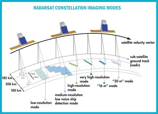
15 RCM Observational Characteristics Daily coverage of Canada's inland, territorial and adjacent waters to support maritime surveillance, including ice monitoring, marine wind monitoring, oil pollution monitoring and ship detection; Ability to image any disaster location in the world within 24 hours to establish the state of critical infrastructure; Ability to monitor all of Canada for disaster mitigation on a regular basis (monthly to twice-weekly) to assess risks and identify damage prone areas; and, Regular coverage of Canada's land mass and inland waters, up to several times weekly in critical periods, for resource and ecosystem monitoring 3 satellites equally-spaced in a dawn-dusk plane Antenna m 2 Power - < 1600 W (peak); < 220 W (average) Orbit km, 100 m radius orbital tube Polarisation - Dual cross selectable pol on all low and medium resolution modes; "experimental" quad pol Imaging Time - 12 minutes/orbit (peak 20 minutes every three orbits) 10 minutes continuous imaging Lifetime - 7 years (each satellite)
16


17 Recommended by the NRC Decadal Survey for near-term launch to address important scientific questions of high societal impact: What drives the changes in ice masses and how does it relate to the climate? How are Earth s carbon cycle and ecosystems changing, and what are the consequences? How do we manage the changing landscape caused by the massive release of energy of earthquakes and volcanoes? Planned by NASA as one of the following 4 Decadal Survey TIER 1 Missions SMAP ICESat-II DESDynI CLARREO Ice sheets and sea level Will there be catastrophic collapse of the major ice sheets, including Greenland and West Antarctic and, if so, how rapidly will this occur? What will be the time patterns of sea level rise as a result? Shifts in ecosystem structure and function in response to climate change How will coastal and ocean ecosystems respond to changes in physical forcing, particularly those subject to intense human harvesting? How will the boreal forest shift as temperature and precipitation change at high latitudes? What will be the impacts on animal migration patterns and invasive species? Extreme events, including earthquakes and volcanic eruptions Are major fault systems nearing release of stress via strong earthquakes Eruptive state of volcanoes? Deformation Biomass Ice Dynamics


18 Polarimetric SAR Multibeam LIDAR Canopy Height g t Biomass Biomass Vegetation Structure Vegetation Disturbance Sea Ice Thickness Repeat Pass InSAR Pass 1 Pass 2 Effects of changing climate on habitats and CO 2 Response of ice sheets to climate change & sea level rise DESDynI will exploit an L-band polarimetric radar operated interferometrically (InSAR) and multibeam lidar Sea Ice and Ice Sheet Dynamics Changes in Earth s Surface Geo-Hazards
 mission to observe global scale change L-band synthetic aperture")
 lidar - Operating in the infrared (1,064 nm) for sensitivity to canopy - 25-m")
19 Common theme in these three disciplines, reflected in mission requirements: Need for finer spatial and temporal sampling DESDynI will join the international fleet of missions to deliver suitable sciencedriven observations with sufficient coverage and sampling Mission Characteristics fulfilling these needs: Multi-year (3/5) mission to observe global scale change L-band synthetic aperture radar (SAR) system - Frequent (8-day) revisit to observe fast processes - Repeat-pass Interferometer (InSAR) for mm-scale accuracy - Multiple polarization for hectare scale biomass and change - Viewable swath of 360 km for complete global coverage at 8 days - 10 m intrinsic ground resolution Multiple-beam (5) lidar - Operating in the infrared (1,064 nm) for sensitivity to canopy - 25-m spatial resolution per beam sampled along-track every 30 m - Sub-meter vertical profiles within 25-m footprint m resolution grid after 5 years 19 19
20 Science Requirement Measurement Requirement Instrument Requirement Ecosystem Structure Global Biomass/Carbon Global Biomass Change Global Biodiversity Dynamics of Ice Ice sheet dynamics Glacier dynamics Sea ice dynamics Deformation Tectonic processes Magmatic processes Sequestration, landslides, and aquifer change Canopy height and structure metrics accurate to 1 m accuracy (0 slope) at m spatial resolution in 5 yrs Biomass at 100 m spatial resolution in low biomass areas Forest change maps, annually 2-D velocity accurate to 1 m/yr at m spatial resolution over ice sheets and glaciers, 5 yrs DEM topography accurate to 1 m at 1 km spatial resolution over ice sheets and glaciers Elevation precise to 3 cm at 25 m profile resolution over sea ice 2-D deformation rates accurate to 1 mm/yr over 50 km length scale at m spatial resolution 2-D deformation accurate to 5-20 mm over 50 km length scale at 100 m resolution, weekly sampling 5-beam profiling lidar operated at near nadir incidence, 25 m profile resolution, Lidar 91-day repeat orbit Quad-pol L-band radar operating in incidence angles at 10 m resolution, seasonally 5-beam profiling lidar operated at near nadir incidence, 25 m profile resolution Lidar 91-day repeat orbit L-band radar operating in 8-day repeat period orbit, global accessibility, at 10 m resolution, continuously over mission Left/Right pointing L-band radar operating in 8-day sampling period orbit Global accessibility 10 m resolution All continuously over mission Left/Right pointing

21 Interseismic strain accumulation at diffusive plate boundary deformation zone An accuracy of 1 mm/yr is needed to study interseismic strain accumulation, plate boundary deformation e.g., Northern metropolitan Los Angeles is shortening at 5 mm/yr. Strain is building up above the Puente Hills Thrust fault. Argus et al mm/yr projected onto InSAR line of sight is 2 mm/yr. Donald Argus
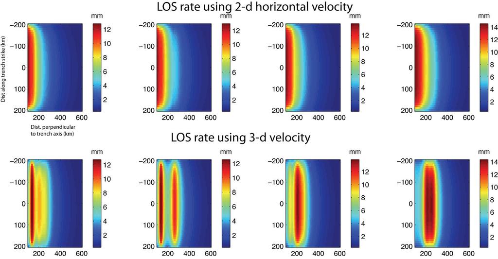
22 Zhen Liu
23 Accuracy improvement by stacking in time Troposphere delay is uncorrelated over several days. If rate is constant, stacking interferograms improves accuracy Stacking interferograms generated every 24 days improves InSAR accuracy to: 1.0 mm/yr 5 year mission 2.2 mm/yr 3 year mission (standard error, horizontal distance 50 km). generated every 8 days 0.6 mm/yr 5 year mission 1.3 mm/yr 3 year mission Donald Argus


24 761 km altitude 8-day repeat 360 km Swath Descending Track Right (Starboard) Pointing Incidence angles degrees 360 km Adjacent Equatorial Ground Track Separation Ascending Track Right (Starboard) Pointing Incidence angles degrees 360 km Swath 761 km altitude 8-day repeat NOTE: NOT TO SCALE! 360 km Adjacent Equatorial Ground Track Separation


25 761 km altitude 8-day repeat Descending Track Left (Port) Pointing Incidence angles km Swath 360 km Adjacent Equatorial Ground Track Separation 761 km altitude 8-day repeat Ascending Track Left (Port) Pointing Incidence angles degrees 360 km Swath NOTE: NOT TO SCALE! 360 km Adjacent Equatorial Ground Track Separation


26 2 observations (1 ascending, 1 descending) in an 8-day cycle Descending Left-Looking coverage shown: Ascending Plan is to acquire this map every cycle Yearly data volume for Solid Earth Science: 163 TB 26
 4 2 1.")
27 Assumes freedom to point left or right at will to target a particular observation Mean Access Interval (Days) Steven Hu, JPL

28 The DESDynI Mission will produce a wide range of products for three distinct science communities Global Ice Global Biomass Tectonic and Volcanic Active Regions Observation Targets (Colored) Some Product Characteristics: 2-D deformation maps of ice sheets - Complete coverage yearly, m resolution, l ti 11 5 m /yr / accuracy 2-D sea-ice motion at both poles - Weekly polar coverage, 5-km resolution, 100 m / day accuracy Biomass and biomass change - Global coverage yearly, m resolution, accuracy of better than 20% 2-D deformation maps of Earth s most severe geohazards - Weekly to yearly over Earth s deforming margins, m resolution, accuracy from mm cm / yr Sea-ice thickness - Monthly-yearly polar coverage, 25 km resolution, better than 60 cm accuracy 28


29 15 m mesh reflector Stowed for Launch in EELV Fairing 4.7 m L-band Polarimetric Radar Feed


 for swath: low impact on data")

30 Strip-mode SAR Standard SAR mode Send a pulse of energy; receive echo; repeat One pulse transmit and receive at a time Swath width limited by radar ambiguities ScanSAR Wider swath low resolution SAR mode Execute sequence as follows: Send a pulse of energy; receive echo; repeat times Repoint the beam across-track to position 2 electrically (almost instantaneous) Send a pulse of energy; receive echo; repeat times Repoint the beam across-track to position 3 electrically (almost instantaneous) Send a pulse of energy; receive echo; repeat times Again, one pulse transmit and receive at a time ScanSAR trades resolution (in along-track dimension) for swath: low impact on data rate Generally poorer ambiguity and radiometric performance than Strip SAR StripSAR ScanSAR 30


31 What is SweepSAR? Transmit pulse over wide beam in elevation Receive echo over narrow beam tracking echo with scanning receive e beam Can require multiple simultaneous receive beams to track multiple echoes A completely new capability Solves the traditional large, complex antenna problem with a large passive reflector and compact digital feed electronics Breaks the standard SAR performance limits by separating transmit and receive apertures with digital beamforming techniques SweepSAR achieves very high h area coverage rates at fine, selectable resolutions, full polarization 31
32 DESDynI is in the formulation phase (pre-phase A) - Radar satellite and instrument being designed by JPL - Lidar satellite and instrument being designed by GSFC Level 1 Science Requirements have been drafted by Steering Group in preparation for Mission Concept Review (MCR) Designs for Radar and Lidar spacecraft and Operations Concept meeting these L1 requirements are reaching maturity for MCR Current plan is to enter Phase A in FY11 President s budget seeks to accelerate all Decadal Survey Mission, including DESDynI 32
33 Mission Sentinel-1A/1B Operations Concept One mode: InSAR Wide Swath, but where? Data Distribution Method Cloud Storage and Distribution; details TBD Data Policy Free and Open Access; details TBD ALOS-2 Campaign; disasters Data Nodes?** Toward Commercial** Radarsat Constellation DESDynI Canada-centric; disasters Systematic Science Observations; disasters ** Observation Plan similar to ALOS-1 is likely New Data Distribution Model Science Nodes; exploring cloud technologies AO driven? And there will be other missions as well providing data Free and Open Access

34 There is a new generation of radar satellites being designed to deliver unprecedented quantities of SAR data This gives a great potential for the InSAR research community to have the kind of data it has been requesting for years Fast-repeat Global Unrestricted Geodetic-grade Whether these data can be used to realize the InSAR potential will depend on many factors, especially data acquisition strategy and data policy Sentinel-1A/1B, albeit at C-band, and possibly other systems seem to be poised to deliver useful data DESDynI is being designed specifically to realize this potential InSAR Everywhere, All the Time is fast approaching!
Current Status of the ALOS-2 Operation and PALSAR-2 Calibration Activities
 Current Status of the ALOS-2 Operation and PALSAR-2 Calibration Activities Takeshi Motohka, Ryo Natsuaki, Yukihiro Kankaku, Shinichi Suzuki, Masanobu Shimada (JAXA) Osamu Isoguchi (RESTEC) CEOS SAR CALVAL
Interferometric Synthetic Aperture Radar (InSAR) and GGOS. Andrea Donnellan NASA/JPL February 21, 2007
 and GGOS. Andrea Donnellan NASA/JPL February 21, 2007") Interferometric Synthetic Aperture Radar (InSAR) and GGOS Andrea Donnellan NASA/JPL February 21, 2007 Sources for Science Objectives Fourth component of EarthScope Involvement: NSF, NASA, USGS, Universities
Interferometric Synthetic Aperture Radar (InSAR) and GGOS Andrea Donnellan NASA/JPL February 21, 2007 Sources for Science Objectives Fourth component of EarthScope Involvement: NSF, NASA, USGS, Universities
New Era of Global Monitoring by ALOS-2: Advanced Land Observing Satellite-2 DAICHI-2 Yuko Suzuki
 New Era of Global Monitoring by ALOS-2: Advanced Land Observing Satellite-2 DAICHI-2 Yuko Suzuki International Relations and Research Department Japan Aerospace Exploration Agency (JAXA) 1 Dawning Era
Future SAR mission concepts
 Future SAR mission concepts PREMIER M. Arcioni, M. Aguirre, P. Bensi, S. D Addio, K. Engel, F. Fois, F. Hélière, M. Kern, A. Lecuyot, C.C. Lin, M. Ludwig, K. Scipal, P. Silvestrin ESTEC, Keplerlaan 1,
Tandem-L: A Mission Proposal for Monitoring Dynamic Earth Processes
 Tandem-L: A Mission Proposal for Monitoring Dynamic Earth Processes A. Moreira, G. Krieger, M. Younis, I. Hajnsek, K. Papathanassiou, M. Eineder, P. Dekker, F. De Zan German Aerospace Center (DLR) Dynamic
Opportunities for advanced Remote Sensing; an outsider s perspective
 Opportunities for advanced Remote Sensing; an outsider s perspective Ramon Hanssen Delft University of Technology 1 Starting questions Can we do more with the data we are already acquire? What s in stock
ALOS-2 Basic Observation Scenario (3rd Edition Ver. A) August 15, 2018 JAXA/ALOS-2 Project
 August 15, 2018 JAXA/ALOS-2 Project") ALOS-2 Basic Observation Scenario (3rd Edition Ver. A) August 15, 2018 JAXA/ALOS-2 Project 1 Details of revision Version Date Page Details of revision A 2018/8/15 P4, 8, 14 Changed the observation mode
ALOS-2 Basic Observation Scenario (3rd Edition Ver. A) August 15, 2018 JAXA/ALOS-2 Project 1 Details of revision Version Date Page Details of revision A 2018/8/15 P4, 8, 14 Changed the observation mode
ALOS-2 Basic Observation Scenario (First Edition) October 10, 2014 JAXA/ALOS-2 Project
 October 10, 2014 JAXA/ALOS-2 Project") ALOS-2 Basic Observation Scenario (First Edition) October 10, 2014 JAXA/ALOS-2 Project 1 Revision details Rev. Date Page Revision details A October 10, 2014 P13,P30 P17 Updated the date of Basic Observation
ALOS-2 Basic Observation Scenario (First Edition) October 10, 2014 JAXA/ALOS-2 Project 1 Revision details Rev. Date Page Revision details A October 10, 2014 P13,P30 P17 Updated the date of Basic Observation
ALOS-2 Basic Observation Scenario (First Edition) January 10, 2014 JAXA/ALOS-2 Project
 January 10, 2014 JAXA/ALOS-2 Project") ALOS-2 Basic Observation Scenario (First Edition) January 10, 2014 JAXA/ALOS-2 Project 1 1.First edition 2.Purpose and Background 3.Approach of the Basic Observation Scenario 4.Basic Observation
ALOS-2 Basic Observation Scenario (First Edition) January 10, 2014 JAXA/ALOS-2 Project 1 1.First edition 2.Purpose and Background 3.Approach of the Basic Observation Scenario 4.Basic Observation
Sentinel-1 Mission Status
 Sentinel-1 Mission Status Pierre Potin, Sentinel-1 Mission Manager 5TH GEOGLAM RAPP Workshop 16-17 May 2017, ESRIN Sentinel-1: Copernicus radar imaging mission for ocean, land, emergency Part of the Copernicus
DLR s TerraSAR-X contributes to international fleet of radar satellites to map the Arctic and Antarctica
 DLR s TerraSAR-X contributes to international fleet of radar satellites to map the Arctic and Antarctica The polar regions play an important role in the Earth system. The snow and ice covered ocean and
Sentinel-1A SAR Interferometry Verification
 Sentinel-1A SAR Interferometry Verification Dirk Geudtner1, Pau Prats2, Nestor Yaguee-Martinez2, Andrea Monti Guarnieri3, Itziar Barat1, Björn Rommen1 and Ramón Torres1 1ESA ESTEC 2DLR, Microwave and Radar
Earth Exploration-Satellite Service (EESS)- Active Spaceborne Remote Sensing and Operations
- Active Spaceborne Remote Sensing and Operations") Earth Exploration-Satellite Service (EESS)- Active Spaceborne Remote Sensing and Operations SRTM Radarsat JASON Seawinds TRMM Cloudsat Bryan Huneycutt (USA) Charles Wende (USA) WMO, Geneva, Switzerland
Earth Exploration-Satellite Service (EESS)- Active Spaceborne Remote Sensing and Operations SRTM Radarsat JASON Seawinds TRMM Cloudsat Bryan Huneycutt (USA) Charles Wende (USA) WMO, Geneva, Switzerland
GEO-VIII November Geohazard Supersites and Natural Laboratories Progress Report. Document 9
 GEO-VIII 16-17 November 2011 Geohazard Supersites and Natural Laboratories Progress Report Document 9 This document is submitted to GEO-VIII for information. Geohazard Supersites and Natural Laboratories
Copernicus Today and Tomorrow GEO Week Group on Earth Observation Geneva, 16 January 2014 The Copernicus Space Infrastructure
 Copernicus Today and Tomorrow GEO Week Group on Earth Observation Geneva, 16 January 2014 The Copernicus Space Infrastructure Thomas Beer, Policy Coordinator, Copernicus Space Office, ESA-ESRIN, Frascati
Towards eenvironment Prague, March GMES Space Component. Josef Aschbacher Head, ESA GMES Space Office
 Towards eenvironment Prague, 25-27 March 2009 GMES Space Component Josef Aschbacher Head, ESA GMES Space Office Prague from Space Segment 2 05 Nov 2003 CNES 2003 GISAT 2007 ESA GSELAND GMES is an EU led
SMAP Data Product Overview
 http://smap.jpl.nasa.gov/ SMAP Data Product Overview ESIP Summer 2014 Copper Mountain, Colorado Barry Weiss Jet Propulsion Laboratory California Institute of Technology Pasadena, CA July 9, 2014 Copyright
Burst overlapping of ALOS-2 PALSAR-2 ScanSAR-ScanSAR interferometry
 Burst overlapping of ALOS-2 PALSAR-2 ScanSAR-ScanSAR interferometry Japan Aerospace Exploration Agency Earth Observation Research Center Ryo Natsuaki, Takeshi Motohka, Shinichi Suzuki and Masanobu Shimada
Current and near-future SAR (and LIDAR) systems
 systems") Current and near-future SAR (and LIDAR) systems Ake Rosenqvist solo Earth Observation, Japan Mexico City, Mexico June 7-9, 2016 1 Current and near-future SARs & LIDARs ALOS-2/PALSAR-2 global mosaics SAOCOM-1A/1B
Current and near-future SAR (and LIDAR) systems Ake Rosenqvist solo Earth Observation, Japan Mexico City, Mexico June 7-9, 2016 1 Current and near-future SARs & LIDARs ALOS-2/PALSAR-2 global mosaics SAOCOM-1A/1B
Radar Remote Sensing: Monitoring Ground Deformations and Geohazards from Space
 Radar Remote Sensing: Monitoring Ground Deformations and Geohazards from Space Xiaoli Ding Department of Land Surveying and Geo-Informatics The Hong Kong Polytechnic University A Question 100 km 100 km
RADAR Remote Sensing Application Examples
 RADAR Remote Sensing Application Examples! All-weather capability: Microwave penetrates clouds! Construction of short-interval time series through cloud cover - crop-growth cycle! Roughness - Land cover,
Surface Deformation Measurements Scientific Requirements & Challenges
 Surface Deformation Measurements Scientific Requirements & Challenges 1st Science and Application Workshop for Germany-Japan Next-Generation SAR M. Eineder, C. Minet, A. Parizzi Tokyo, 27.6.2013 Tandem-L
APPENDIX 2 OVERVIEW OF THE GLOBAL PRECIPITATION MEASUREMENT (GPM) AND THE TROPICAL RAINFALL MEASURING MISSION (TRMM) 2-1
 AND THE TROPICAL RAINFALL MEASURING MISSION (TRMM) 2-1") APPENDIX 2 OVERVIEW OF THE GLOBAL PRECIPITATION MEASUREMENT (GPM) AND THE TROPICAL RAINFALL MEASURING MISSION (TRMM) 2-1 1. Introduction Precipitation is one of most important environmental parameters.
APPENDIX 2 OVERVIEW OF THE GLOBAL PRECIPITATION MEASUREMENT (GPM) AND THE TROPICAL RAINFALL MEASURING MISSION (TRMM) 2-1 1. Introduction Precipitation is one of most important environmental parameters.
Geohazard Supersites and Natural Laboratories
 Geohazard Supersites and Natural Laboratories FRINGE 2011, Frascati, Italy, September 19, 2011 Wolfgang Lengert, ESA Falk Amelung, University of Miami, GEO task lead Craig Dobson, NASA, CEOS task lead
Status DLR (TerraSAR X / TanDEM X)
") SAR Coordination Working Meeting 5 Status DLR (TerraSAR X / TanDEM X) Dana Floricioiu, Achim Roth Imaging Requirements for TerraSAR X & TanDEM X Missions Ice Sheets: TSX supports Greenland outlet glaciers,
SAR Coordination Working Meeting 5 Status DLR (TerraSAR X / TanDEM X) Dana Floricioiu, Achim Roth Imaging Requirements for TerraSAR X & TanDEM X Missions Ice Sheets: TSX supports Greenland outlet glaciers,
Orbit Design Marcelo Suárez. 6th Science Meeting; Seattle, WA, USA July 2010
 Orbit Design Marcelo Suárez Orbit Design Requirements The following Science Requirements provided drivers for Orbit Design: Global Coverage: the entire extent (100%) of the ice-free ocean surface to at
Remote Sensing I: Basics
 Remote Sensing I: Basics Kelly M. Brunt Earth System Science Interdisciplinary Center, University of Maryland Cryospheric Science Laboratory, Goddard Space Flight Center kelly.m.brunt@nasa.gov (Based on
Infrastructure monitoring using SAR interferometry
 Infrastructure monitoring using SAR interferometry Hossein Nahavandchi Roghayeh Shamshiri Norwegian University of Science and Technology (NTNU), Department of Civil and Environmental Engineering Geodesy
HY-2A Satellite User s Guide
 National Satellite Ocean Application Service 2013-5-16 Document Change Record Revision Date Changed Pages/Paragraphs Edit Description i Contents 1 Introduction to HY-2 Satellite... 1 2 HY-2 satellite data
A new era of geodetic big data - challenges and opportunities Tim Wright (COMET, University of
 A new era of geodetic big data - challenges and opportunities Tim Wright (COMET, University of Leeds) S @NERC_COMET N A New Era of Geodetic Big Data? GEM Strain Rate Model 17,491 GNSS sites included in
ACHIEVING THE ERS-2 ENVISAT INTER-SATELLITE INTERFEROMETRY TANDEM CONSTELLATION.
 ACHIEVING THE ERS-2 ENVISAT INTER-SATELLITE INTERFEROMETRY TANDEM CONSTELLATION M. A. Martín Serrano (1), M. A. García Matatoros (2), M. E. Engdahl (3) (1) VCS-SciSys at ESA/ESOC, Robert-Bosch-Strasse
sentinel-2 COLOUR VISION FOR COPERNICUS
 sentinel-2 COLOUR VISION FOR COPERNICUS SATELLITES TO SERVE By providing a set of key information services for a wide range of practical applications, Europe s Copernicus programme is providing a step
JAXA s Contributions to the Climate Change Monitoring
 0 JAXA s Contributions to the Climate Change Monitoring June 7, 2011 Takao Akutsu Planning Manager Japan Aerospace Exploration Agency (JAXA) Japanese Main Activities of Earth Observation 1 GEOSS 10 years
Ice & Snow Session. Chairs: J. Mouginot & N. Gourmelen
 Ice & Snow Session Chairs: J. Mouginot & N. Gourmelen Session 12 talks and 10 posters Antarctic ice motion, ground-line detection and monitoring, dynamics ice-fluctuations in Antarctica and Greenland,
Impact of the Envisat Mission Extension on SAR data
 Impact of the Envisat Mission Extension on SAR data Impact of Envisat extension on SAR data Prepared by nuno miranda Reference Issue 0.9 Revision Date of Issue 23 August 2010 Status Preliminary version
sentinel-3 A BIGGER PICTURE FOR COPERNICUS
 sentinel-3 A BIGGER PICTURE FOR COPERNICUS SATELLITES TO SERVE By providing a set of key information services for a wide range of practical applications, Europe s Copernicus programme has been put in place
Geoscience Australia Report on Cal/Val Activities
 Medhavy Thankappan Geoscience Australia Agency Report I Berlin May 6-8, 2015 Outline 1. Calibration / validation at Geoscience Australia Corner reflector infrastructure for SAR calibration (for information)
Impact of the Envisat Mission Extension on SAR data
 Impact of the Envisat Mission Extension on SAR data Impact of Envisat Mission Extension on SAR data - 1.0 Prepared by Nuno Miranda, Berthyl Duesmann, Monserrat Pinol, Davide Giudici, Davide D Aria Reference
SMAP and SMOS Integrated Soil Moisture Validation. T. J. Jackson USDA ARS
 SMAP and SMOS Integrated Soil Moisture Validation T. J. Jackson USDA ARS Perspective Linkage of SMOS and SMAP soil moisture calibration and validation will have short and long term benefits for both missions.
Interferometric Synthetic Aperture Radar (InSAR): Its Past, Present and Future
: Its Past, Present and Future") Interferometric Synthetic Aperture Radar (InSAR): Its Past, Present and Future by Zhong Lu, Ohig Kwoun, and Russell Rykhus Introduction Very simply, interferometric synthetic aperture radar (InSAR) involves
Interferometric Synthetic Aperture Radar (InSAR): Its Past, Present and Future by Zhong Lu, Ohig Kwoun, and Russell Rykhus Introduction Very simply, interferometric synthetic aperture radar (InSAR) involves
Geohazard Supersites and Natural Laboratories
 Geohazard Supersites and Natural Laboratories FRINGE 2011, Frascati, Italy, September 19, 2011 Wolfgang Lengert, ESA Falk Amelung, University of Miami, GEO task lead Craig Dobson, NASA, CEOS task lead
Retrieving 3D deformation pattern of a landslide with hiresolution InSAR and in-situ measurements: Just landslide case-study
 Retrieving 3D deformation pattern of a landslide with hiresolution InSAR and in-situ measurements: Just landslide case-study Zbigniew Perski (1), Petar Marinković (2), Yngvar Larsen (3), Tomasz Wojciechowski
DUAL-POLARIZED COSMO SKYMED SAR DATA TO OBSERVE METALLIC TARGETS AT SEA
 DUAL-POLARIZED COSMO SKYMED SAR DATA TO OBSERVE METALLIC TARGETS AT SEA F. Nunziata, M. Montuori and M. Migliaccio Università degli Studi di Napoli Parthenope Dipartimento per le Tecnologie Centro Direzionale,
Related missions and programs for Snowfall and Snow Hydrology of JAXA
 Related missions and programs for Snowfall and Snow Hydrology of JAXA ALOS AVNIR-2 2006/11/05 Shuji Shimizu Japan Aerospace Exploration Agency (JAXA) Earth Observation Research Center (EORC) JAXA Earth
K&C Phase 4 Status report. Ice Sheet Monitoring using ALOS-2. University of California, Irvine 2 JPL
 K&C Phase 4 Status report Ice Sheet Monitoring using ALOS-2 Bernd Scheuchl 1, Jeremie Mouginot 1, Eric Rignot 1,2 1 University of California, Irvine 2 JPL Science Team meeting #24 Tokyo, Japan, January
Chart 1 Changing the Perspective: Atmospheric Research on the ISS Prof. Dr. Hansjörg Dittus German Aerospace Center (DLR)
") www.dlr.de Chart 1 Changing the Perspective: Atmospheric Research on the ISS Prof. Dr. Hansjörg Dittus German Aerospace Center (DLR) www.dlr.de Chart 2 DLR German Aerospace Center Research Institution
www.dlr.de Chart 1 Changing the Perspective: Atmospheric Research on the ISS Prof. Dr. Hansjörg Dittus German Aerospace Center (DLR) www.dlr.de Chart 2 DLR German Aerospace Center Research Institution
Dual-Frequency Ku- Band Radar Mission Concept for Snow Mass
 Dual-Frequency Ku- Band Radar Mission Concept for Snow Mass Chris Derksen Environment and Climate Change Canada Study Team: Climate Research Division/Meteorological Research Division, ECCC Canadian Space
Committee on Earth Observation Satellites. The CEOS Volcano Demonstrator Rationale and Implementation
 Committee on Earth Observation Satellites The CEOS Volcano Demonstrator Rationale and Implementation Why focus on volcanoes? Over 300,000 people have been killed by volcanoes since the 1600s Globally,
Ivana Zinno, Francesco Casu, Claudio De Luca, Riccardo Lanari, Michele Manunta. CNR IREA, Napoli, Italy
 An Unsupervised Implementation of the P-SBAS DiNSAR Algorithm for Processing Large Data Volumes through Distributed Computing Infrastructures within Operational Environments Ivana Zinno, Francesco Casu,
Sentinel-1 Mission Status
 Sentinel-1 Mission Status Pierre Potin, Sentinel-1 Mission Manager, ESA Luca Martino, Technical Support Engineer, ESA... and the Sentinel-1 operations team PSTG SAR Coordination Working Group 14 December
The Polar Ice Sheets Monitoring Project A Coordinated Response from Space Agencies
 The Polar Ice Sheets Monitoring Project A Coordinated Response from Space Agencies Yves Crevier / Members of the PSTG SAR Coordination WG Canadian Space Agency CEOS SIT-28 Meeting Hampton, Virginia, USA
Ice surveys, meteorological and oceanographic data What is available and up-to-date?
 Ice surveys, meteorological and oceanographic data What is available and up-to-date? Leader of the Norwegian Ice Service +47 77 62 13 15 - nick.hughes@met.no Norwegian Meteorological Institute met.no 1
DLR/TerraSAR-X: development of IPY portofolio since the SAR coordination workshop (CSA, March 2008) Dana Floricioiu
 Dana Floricioiu") DLR/TerraSAR-X: development of IPY portofolio since the SAR coordination workshop (CSA, March 2008) Dana Floricioiu STG-3 Meeting, ESRIN Frascati 5/6 May 2008 Acquisitions themes adopted at the SAR coordination
DLR/TerraSAR-X: development of IPY portofolio since the SAR coordination workshop (CSA, March 2008) Dana Floricioiu STG-3 Meeting, ESRIN Frascati 5/6 May 2008 Acquisitions themes adopted at the SAR coordination
Floating Ice: Progress in Addressing Science Goals
 Polar Floating Ice: Progress in Addressing Science Goals Stephen Howell 1, Leif Toudal Pedersen 2 and Roberto Saldo 3 1 Environment Canada, Climate Research Division, Toronto, Canada 2 Danish Meteorological
Ice sheet mass balance from satellite altimetry. Kate Briggs (Mal McMillan)
") Ice sheet mass balance from satellite altimetry Kate Briggs (Mal McMillan) Outline Background Recap 25 year altimetry record Recap Measuring surface elevation with altimetry Measuring surface elevation
Ice sheet mass balance from satellite altimetry Kate Briggs (Mal McMillan) Outline Background Recap 25 year altimetry record Recap Measuring surface elevation with altimetry Measuring surface elevation
Sentinel-1 Mission Overview
 Sentinel-1 Mission Overview N. Miranda, ESA S-1 Space Project Team S-1 PDGS Team PolinSAR 2013 Info day Outline Mission objectives S-1 Acquisition Modes S-1 Piloting Modes S-1 Product Family S-1 Product
Current and Upcoming NASA Hurricane Measurement Missions National Hurricane Conference
 NASA Science Mission Directorate Earth Science Division Applied Sciences Program Current and Upcoming NASA Hurricane Measurement Missions National Hurricane Conference April 18, 2017 Formulation Implementation
JAXA agency report. Masumi MATSUNAGA Satellite Applications and Operations Center(SAOC), JAXA
, JAXA") JAXA agency report Masumi MATSUNAGA Satellite Applications and Operations Center(SAOC), JAXA JAXA Activities Space Transportation Human Space Activities Satellite Programs Lunar & Planetary Exploration
JAXA agency report Masumi MATSUNAGA Satellite Applications and Operations Center(SAOC), JAXA JAXA Activities Space Transportation Human Space Activities Satellite Programs Lunar & Planetary Exploration
K&C Phase 4 Status report. Use of short-period ALOS-2 observations for vegetation characterization and classification
 K&C Phase 4 Status report Use of short-period ALOS-2 observations for vegetation characterization and classification Paul Siqueira University of Massachusetts, Amherst Science Team meeting #22 Tokyo, Japan,
The financial and communal impact of a catastrophe instantiated by. volcanoes endlessly impact on lives and damage expensive infrastructure every
 Chapter 1 Introduction The financial and communal impact of a catastrophe instantiated by geophysical activity is significant. Landslides, subsidence, earthquakes and volcanoes endlessly impact on lives
The March 11, 2011, Tohoku-oki earthquake (Japan): surface displacement and source modelling
: surface displacement and source modelling") The March 11, 2011, Tohoku-oki earthquake (Japan): surface displacement and source modelling Salvatore Stramondo Bignami C., Borgstrom S., Chini M., Guglielmino F., Melini D., Puglisi G., Siniscalchi V.,
The March 11, 2011, Tohoku-oki earthquake (Japan): surface displacement and source modelling Salvatore Stramondo Bignami C., Borgstrom S., Chini M., Guglielmino F., Melini D., Puglisi G., Siniscalchi V.,
Wave processes in Arctic Seas, observed from TerraSAR-X
 DISTRIBUTION STATEMENT A. Approved for public release; distribution is unlimited. Wave processes in Arctic Seas, observed from TerraSAR-X Susanne Lehner DLR German Air and Space Research Center Earth Observation
Emergency Management Service (EMS) mapping
 mapping") GMES Emergency Management Service (EMS) mapping Frédéric BASTIDE GMES unit, European Commission UN-SPIDER Expert Meeting: "Crowdsource Mapping for Disaster Risk Management and Emergency Response" 3-5 December,
GMES Emergency Management Service (EMS) mapping Frédéric BASTIDE GMES unit, European Commission UN-SPIDER Expert Meeting: "Crowdsource Mapping for Disaster Risk Management and Emergency Response" 3-5 December,
Canadian Space Agency Update. STG 3 ESRIN, Frascati May 5-6, 2008 Yves Crevier
 Canadian Space Agency Update STG 3 ESRIN, Frascati May 5-6, 2008 Yves Crevier Role of CSA in IPY Ensure the use of Space Technologies in IPY Science initiatives Guarantee fluid and continued availability
Teruyuki Nakajima Director, Earth Observation Research Center (EORC) Japan Aerospace Exploration Agency (JAXA)
 Japan Aerospace Exploration Agency (JAXA)") Tokyo Inter. Conference on the Forest Governance Initiative - Improving Forest Governance using Forest Early Warning Systems and Satellite Technologies - October 24-26, 2017 Teruyuki Nakajima Director,
Tokyo Inter. Conference on the Forest Governance Initiative - Improving Forest Governance using Forest Early Warning Systems and Satellite Technologies - October 24-26, 2017 Teruyuki Nakajima Director,
The Potential of High Resolution Satellite Interferometry for Monitoring Enhanced Oil Recovery
 The Potential of High Resolution Satellite Interferometry for Monitoring Enhanced Oil Recovery Urs Wegmüller a Lutz Petrat b Karsten Zimmermann c Issa al Quseimi d 1 Introduction Over the last years land
Gets Boost from a New Satellite
 Earthquake Monitoring Gets Boost from a New Satellite By J. R. Elliott, A. J. Elliott, A. Hooper, Y. Larsen, P. Marinkovic, T. J. Wright Fig. 1. Sentinel-1A interferogram built by comparing scans near
CopernicusEU. the EU's Earth Observation Programme. Sara Zennaro Atre Delegation of the European Union to Japan
 Copernicus the EU's Earth Observation Programme Sara Zennaro Atre Delegation of the European Union to Japan Status Overview, Sept 2016 & Ocean Policies Seminar 4 October 2016 ollow us on: Copernicus EU
Orbits for Polar Applications Malcolm Macdonald
 Orbits for Polar Applications Malcolm Macdonald www.strath.ac.uk/mae 25 June 2013 malcolm.macdonald.102@strath.ac.uk Slide 1 Image Credit: ESA Overview Where do we currently put spacecraft? Where else
The Orbit Control of ERS-1 and ERS-2 for a Very Accurate Tandem Configuration
 The Orbit Control of ERS-1 and ERS-2 for a Very Accurate Tandem Configuration Mats Rosengren European Space Operations Centre Robert Bosch Str 5 D64293 Darmstadt Germany Email: mrosengr@esoc.esa.de Abstract
to: Interseismic strain accumulation and the earthquake potential on the southern San
 Supplementary material to: Interseismic strain accumulation and the earthquake potential on the southern San Andreas fault system by Yuri Fialko Methods The San Bernardino-Coachella Valley segment of the
EXTRACTION OF FLOODED AREAS DUE THE 2015 KANTO-TOHOKU HEAVY RAINFALL IN JAPAN USING PALSAR-2 IMAGES
 EXTRACTION OF FLOODED AREAS DUE THE 2015 KANTO-TOHOKU HEAVY RAINFALL IN JAPAN USING PALSAR-2 IMAGES F. Yamazaki a, *, W. Liu a a Chiba University, Graduate School of Engineering, Chiba 263-8522, Japan
Japanese Programs on Space and Water Applications
 Japanese Programs on Space and Water Applications Tamotsu IGARASHI Remote Sensing Technology Center of Japan June 2006 COPUOS 2006 Vienna International Centre Water-related hazards/disasters may occur
Volcanoes Session. Chairs: Y. Fukushima & G. Puglisi
 Volcanoes Session Chairs: Y. Fukushima & G. Puglisi Presentation Summary We had presentations on volcanoes all over the world, more than the last FRINGE workshops: Etna, Campi Flegrei, Ethiopian rift,
Sentinel-1 Long Duration Mutual Interference
 MPC-S1 Sentinel-1 Long Duration Mutual Interference Reference: Nomenclature: MPC-0432 DI-MPC-ARC Issue: 1. 0 Date: 2018,Dec.04 MPC-0432 DI-MPC-ARC V1.0 2018,Dec.04 i.1 Chronology Issues: Issue: Date: Reason
GG S. Internal Vision of GGOS. Markus Rothacher. GFZ Potsdam
 Internal Vision of GGOS Markus Rothacher GFZ Potsdam GGOS Retreat DGFI in Munich February 15-16, 2006 Contents Motivation Four Levels of Products of the IAG Services: First Level: Raw Data Collection Second
THE COPERNICUS PROGRAMME
 THE COPERNICUS PROGRAMME Jolyon Martin, Sentinel Data Access Manager & Sentinel-5P Operations Manager, ESA Pierre Potin, Sentinel-1 Mission Manager, ESA Earth Observation Showcase Emerging Applications
Orbit and Transmit Characteristics of the CloudSat Cloud Profiling Radar (CPR) JPL Document No. D-29695
 JPL Document No. D-29695") Orbit and Transmit Characteristics of the CloudSat Cloud Profiling Radar (CPR) JPL Document No. D-29695 Jet Propulsion Laboratory California Institute of Technology Pasadena, CA 91109 26 July 2004 Revised
Orbit and Transmit Characteristics of the CloudSat Cloud Profiling Radar (CPR) JPL Document No. D-29695 Jet Propulsion Laboratory California Institute of Technology Pasadena, CA 91109 26 July 2004 Revised
GCOM-W1 now on the A-Train
 GCOM-W1 now on the A-Train GCOM-W1 Global Change Observation Mission-Water Taikan Oki, K. Imaoka, and M. Kachi JAXA/EORC (& IIS/The University of Tokyo) Mini-Workshop on A-Train Science, March 8 th, 2013
Application of Net Present Benefit to InSAR Monitoring. Audrey K. Moruza, Virginia Transportation Research Council (VDOT)
") Application of Net Present Benefit to InSAR Monitoring Audrey K. Moruza, Virginia Transportation Research Council (VDOT) 11/27/2017 2 11/27/2017 3 11/27/2017 4 In S A R Interferometric Synthetic Aperture
Application of Net Present Benefit to InSAR Monitoring Audrey K. Moruza, Virginia Transportation Research Council (VDOT) 11/27/2017 2 11/27/2017 3 11/27/2017 4 In S A R Interferometric Synthetic Aperture
Towards the use of SAR observations from Sentinel-1 to study snowpack properties in Alpine regions
 Towards the use of SAR observations from Sentinel-1 to study snowpack properties in Alpine regions Gaëlle Veyssière, Fatima Karbou, Samuel Morin et Vincent Vionnet CNRM-GAME /Centre d Etude de la Neige
Satellite Remote Sensing for Ocean
 Satellite Remote Sensing for Ocean August 17, 2017 Masatoshi Kamei RESTEC All rights reserved RESTEC 2015 Contents 1. About RESTEC and Remote Sensing 2. Example of Remote Sensing Technology 3. Remote Sensing
Thermal And Near infrared Sensor for carbon Observation (TANSO) onboard the Greenhouse gases Observing SATellite (GOSAT) Research Announcement
 onboard the Greenhouse gases Observing SATellite (GOSAT) Research Announcement") Thermal And Near infrared Sensor for carbon Observation (TANSO) onboard the Greenhouse gases Observing SATellite (GOSAT) Research Announcement Appendix C Operation Policies of GOSAT and Basic Observation
Thermal And Near infrared Sensor for carbon Observation (TANSO) onboard the Greenhouse gases Observing SATellite (GOSAT) Research Announcement Appendix C Operation Policies of GOSAT and Basic Observation
Interpretation of Polar-orbiting Satellite Observations. Atmospheric Instrumentation
 Interpretation of Polar-orbiting Satellite Observations Outline Polar-Orbiting Observations: Review of Polar-Orbiting Satellite Systems Overview of Currently Active Satellites / Sensors Overview of Sensor
Volcano Monitoring on a Regional Scale:
 Volcano Monitoring on a Regional Scale: Results from the CEOS Disaster Risk Management Volcano Pilot David Arnold 1 Juliet Biggs 1 Francisco Delgado 2 Matt Pritchard 2 Susi Ebmeier 1 Mike Poland 3 Simona
Improved sea-ice monitoring for the Baltic Sea Project summary
 Improved sea-ice monitoring for the Baltic Sea Project summary Leif E.B. Eriksson (1), Karin Borenäs (2), Wolfgang Dierking (3), Anders Berg (1) and Per Pemberton (2) (1) Chalmers University of Technology,
NASA Jet Propulsion Laboratory Data Products
 NASA Jet Propulsion Laboratory Data Products 17 April 2014 Emergency Response Spatial Tools Technical Interchange Maggi Glasscoe Margaret.T.Glasscoe@jpl.nasa.gov Sang-Ho Yun Sang-Ho.Yun@jpl.nasa.gov www.nasa.gov
Earth Observatory of Singapore. Nina Lin 22 Jan 2018
 Earth Observatory of Singapore Nina Lin 22 Jan 2018 EOS Our Mission Our Mission Director Prof. Kerry Sieh The Earth Observatory of Singapore conducts fundamental research on earthquakes, volcanic eruptions,
Osservazione della terra da piattaforme remore ed in-situ fisse e mobili. Massimo Caccia CNR - ISSIA
 Osservazione della terra da piattaforme remore ed in-situ fisse e mobili Massimo Caccia CNR - ISSIA massimo.caccia@ge.issia.cnr.it 1 Research themes geo-physical monitoring environmental hazards monitoring
Introduction of PALSAR and PALSAR Data Application Plan
 Introduction of PALSAR and PALSAR Data Application Plan September 19 th, 2006 Tomonori Deguchi deguchi@ersdac.or.jp Earth Remote Sensing Data Analysis Center (ERSDAC) http://www.ersdac.or.jp Contents 1.
DETECTING ICE MOTION IN GROVE MOUNTAINS, EAST ANTARCTICA WITH ALOS/PALSAR AND ENVISAT/ASAR DATA
 DETECTING ICE MOTION IN GROVE MOUNTAINS, EAST ANTARCTICA WITH ALOS/PALSAR AND ENVISAT/ASAR DATA TIAN Xin (1), LIAO Mingsheng (1), ZHOU Chunxia (2), ZHOU Yu (3) (1) State Key Laboratory of Information Engineering
The Geohazard Supersites and Natural Laboratories (GSNL).
.") The Geohazard Supersites and Natural Laboratories (GSNL). Falk Amelung, University of Miami Mike Poland, Hawaii Volcano Observatory Scott Baker, U of Miami, Unavco Outline: Overview over GSNL (Phase 2)
The Geohazard Supersites and Natural Laboratories (GSNL). Falk Amelung, University of Miami Mike Poland, Hawaii Volcano Observatory Scott Baker, U of Miami, Unavco Outline: Overview over GSNL (Phase 2)
Earth Science Flight Mission Overview
 Earth Science Flight Mission Overview Nand Topiwala Science Mission Directorate NASA Headquarters April 25, 2007 Earth Science Missions Afternoon Constellation, or A-Train, Multi-Satellite Observatory
Systems Engineering in Venus Satellite
 Systems Engineering in Venus Satellite How to benefit from system engineering process in designing a microsatellite Jacob Herscovitz Venus Project Manager RAFAEL - Israel 1 Presentation Contents Introduction
Q1-Q CEOS Seismic Pilot report. CEOS Thematic Pilots
 CEOS Thematic Pilots Q1-Q2 2016 CEOS Seismic Pilot report Seismic Pilot/ Objective A, B and C March 2016- PI or PoC: Philippe Bally August 2016 (ESA) and Stefano Salvi (INGV). Collaborating organisations:
Geomorphologic Mapping by Airborne Laser Scanning in Southern Victoria Land
 Geomorphologic Mapping by Airborne Laser Scanning in Southern Victoria Land Bea Csatho, Terry Wilson, Tony Schenk, Garry McKenzie, Byrd Polar Research Center, The Ohio State University, Columbus, OH William
The ICESat 2 Mission Laser altimetry of ice, clouds and land elevation
 OSTM SWT San Diego October 2011 The ICESat 2 Mission Laser altimetry of ice, clouds and land elevation and also ocean, coastal, and continental waters Charon Birkett, ESSIC/UMD on behalf of T. Markus,
Sentinel and ESA Third-Party Mission data access and processing tools
 Sentinel and ESA Third-Party Mission data access and processing tools Magdalena Fitrzyk RSAC c/o ESA ESRIN 11/09/2018 Content Copernicus Sentinel missions Copernicus Open Access Hub: Sentinels Data Access
China France. Oceanography S A T. The CFOSAT project. e l l i t e. C. Tison (1), D. Hauser (2), A. Mouche (3) CNES, France (2)
, D. Hauser (2), A. Mouche (3) CNES, France (2)") China France The CFOSAT project C. Tison (1), D. Hauser (2), A. Mouche (3) (1) CNES, France (2) OVSQ, CNRS, LATMOS-IPSL, France (3) IFREMER, LOS, France celine.tison@cnes.fr Oceanography S A T e l l i
China France The CFOSAT project C. Tison (1), D. Hauser (2), A. Mouche (3) (1) CNES, France (2) OVSQ, CNRS, LATMOS-IPSL, France (3) IFREMER, LOS, France celine.tison@cnes.fr Oceanography S A T e l l i
GEOSC/METEO 597K Kevin Bowley Kaitlin Walsh
 GEOSC/METEO 597K Kevin Bowley Kaitlin Walsh Timeline of Satellites ERS-1 (1991-2000) NSCAT (1996) Envisat (2002) RADARSAT (2007) Seasat (1978) TOPEX/Poseidon (1992-2005) QuikSCAT (1999) Jason-2 (2008)