MOPED Monitoring of Oil Pollution using Earth Observation Data
|
|
|
- Sherilyn Parks
- 5 years ago
- Views:
Transcription

1 MOPED Monitoring of Oil Pollution using Earth Observation Data ESA/INTAS Project Earth Sciences and the Environment: Water Quality
2 Contributors Valborg Byfield National Oceanograph Centre, Southampton, UK with Wendy King, Dept.of Chemistry, University of Southampton Andrey G. Kostianoy Shirshov Institute of Oceanology, Moscow, Russia Stanislav Ermakov Institute of Applied Physics, Russian Academy of Sciences, Nizhny Novgorod, Sergey Stanichny, Marine Hydrophysical Insitute, Ukrainian Academy of Sciences, Sevastopol Olga Lavrova Space Research Insitute, Russian Academy of Sciences, Moscow Ramiz Mamedov Institute of Geography, Azerbaijan Academy of Sciences, Baku Martin Gade Centre for Marine and Atmospheric Sciences, University of Hamburg, Germany Jose da Silva Institute of Oceanography, University of Lisbon, Portugal And members of their teams
3 Overall aim of MOPED Develop recommendations for a system to use all available information from satellites and independent sources To detect and (where possible) quantify oil pollution, whilst reducing the risk of false positives, and To provide information for use in models to predict oil spill transport and evolution, or carry out hind-casts to identify sources of observed spills
4 Research Objectives Collect, analyse, co-locate and archive satellite data from selected case studies (T2) Retrieve geophysical parameter influencing oil spill evolution and appearance (T3) Improved models for wave damping and backscatter in the presence of surface films (T4) Improved forecast model for oil spill drift (T5) Develop multi-sensor algorithms (T6) Recommendations for a system using all available information to monitor oil pollution (T6)

5 Main areas of interest Main areas : Black Sea Caspian Sea Drawing on past work in other areas, particularly the Baltic
6 A synergistic use of multi-sensor multi-platform satellite data MHI MHI IKI UoL NOC? MHI? IKI UoL NOC? MHI??
7 Baltic Sea case studies Building on Lukoil-Kaliningradmorneft Project Satellite monitoring of oil spills NRC and oil-water contrast (ASAR, RADARSAT) Optical data (MODIS 250m) Satellite derived geophysical parameters Surface wind field (QuikSCAT, + NCEP,ECMWF and MM5 for downscaling) Wave height (along-track altimetry, Topex, Jason) Fronts and mesoscale current dynamics SST (AVHRR, MODIS-Terra and -Aqua) Chlorophyll, radiances (MODIS, SeaWiFS) SMHI SeaTrack numerical model (oil spill drift) Meteorological observations


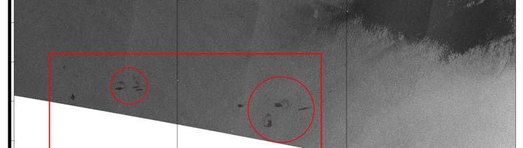
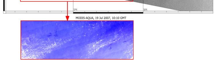
8 Right: ENIVSAT ASAR WSM image from SE Baltic Sea, 30 July 2004, 20:08 GMT. ESA 2004 Distributed by Kongsberg Satellite Station 1. Chain of oil spills in the Bay of Gdansk; 2. round patch of unknown nature. Ancillary satellite and meteo information is required for full interpretation Below: MODIS Terra 250m, 30 July 09:40 GMT , Andrey G. Kostianoy


9 Comparison with model output Forecast: D-6 for 48 hours with SMHI SeaTrack Web model Oil spills will move south with wind and current fields, towards Vistula Spit. ASAR and MODIS data: Westward drift along vortex streamlines Reason for discrepancy meso- and small-scale dynamical features accounted for in model Need to include current field in eddies, dipoles, jets, filaments, meanders, etc. MODIS Aqua 11:35 GMT


10 Daily forecast of oil spill drift from D-6 for 48 hours basing on SMHI SeaTrack Web model D


11 Potential probability of oil spill drift from D-6 6 oil platform 9% 9% 7% 5% 67% (35%) 3%
12 Black Sea case studies Analyses of multi-sensor satellite data Satellite monitoring of oil spills NRC and oil-water contrast (ASAR, ERS-2, others?) Optical data (MODIS 250m, MERIS FR L1B) Satellite derived geophysical parameters Surface wind field (QuikSCAT + NCEP,ECMWF and MM5 model for downscaling) Wave height (along-track altimetry, Topex, Jason, RA-2) Fronts and mesoscale current dynamics SST (AVHRR NOAA, MODIS-Terra and -Aqua) Chlorophyll, radiances (MODIS, MERIS, SeaWiFS) Black Sea operational model (National Space Agency of Ukraine)

13 Surface velocities culculated by MCC


14 ASAR and MODIS (in sun glitter pattern) data detect oil pollution by ship discharge
 And predicted daily shift of the oil spill from red to yellow.")
15 Surface currents field by Black Sea Operational model output ( And predicted daily shift of the oil spill from red to yellow.

16 Ship discharge Platform Ship
17 Caspian Sea case studies Analyses of multi-sensor satellite data Satellite monitoring of oil spills NRC and oil-water contrast (ASAR, ERS-2, RADARSAT) Optical data (MODIS 250m, MERIS FR L1B) Satellite derived geophysical parameters Surface wind field (QuikSCAT + NCEP,ECMWF and MM5 for downscaling) Wave height (along-track altimetry, Topex, Jason, RA-2) Fronts and mesoscale current dynamics SST (AVHRR NOAA, MODIS-Terra and -Aqua) Chlorophyll, radiances (MODIS, MERIS, SeaWiFS) 3D hybrid flow/transport model for Caspian Sea


18 Caspian Sea ¾ Current stage: collection, prelim. analysis and archiving VIS (NOAA) SST (NOAA) Chl (SeaWiFS)
19 Black Sea field experiments Effect of artificial films on small-scale waves and radar backscatter and Doppler shift Location: MHI research platform Sensors IAP: Ka-/X-band Doppler scatterometer, optical spectrum analyzer, digital camera MHI: wire gauge, anemometer Substances vegetable and olive oil dodecyl alcohol diesel fuel

20 Apparatus X-band scatterometer Optical Spectrum Analyzer Ka-band scatterometer
21 Experiment with artificial slicks of Olive oil strong damping at X/Ka-bands. Diesel fuel weak damping intencity OSA 20 cm intencity VO VO DA OLO VO OSA 5 cm intencity X-band intencity Ka-band time, min Wind speed, m/s Wind 2 velocity to be checked! time, min
22 Contrasts in slicks Low wind conditions 1000 OSA 10 Radars Photo Contrast Ka-band X-band Contrast OSA Wavenumber, rad/cm Wavenumber, rad/cm Dodecyl alcohol slick (film elasticity E=50-70 mn/m) Veg. oil slick (film elasticity E=12-15 mn/m) Camera and OSA data agree, radar contrast larger Low winds: maximum wave damping at C-band Strong radar Doppler shift at low winds
23 Training material UNESCO Bilko software Training lessons based on satellite data of marine oil pollution Image processing techniques Filtering, transects, contrast calculations Image co-location Guided data interpretation Background information Questions to test student understanding Model answers for student/teachers working alone

24 Threshold 2400 Unfiltered Filtered Threshold 2100
25 Summary of work to date.. Data base SAR data for Black Sea, Baltic: ancillary data identified Caspian Sea data to be collected and analysed Retrieval of geophysical parameters begun Preliminary model runs and data analysis Baltic and Black Sea only 2 weeks field work: preliminary results Experiments with artificial slicks show wave-damping properties and oil-water contrast in line with expectations Sampled slicks show hysteresis Optical algorith development Work to identify suitable images ongoing Oil spill lesson 1 on Baltic case study under review
26 Website:
OPERATIONAL SATELLITE MONITORING OF OIL SPILL POLLUTION IN THE SOUTHEASTERN BALTIC SEA: 1.5 YEARS EXPERIENCE
 US/EU-Baltic International Symposium May 23-25, 2006 Klaipeda, Lithuania OPERATIONAL SATELLITE MONITORING OF OIL SPILL POLLUTION IN THE SOUTHEASTERN BALTIC SEA: 1.5 YEARS EXPERIENCE 2006, Andrey G. Kostianoy
DEMOSS. Title: Development of Marine Oil Spills/slicks Satellite monitoring System elements for the Black Sea, Caspian Sea and /Kara/Barents Seas
 DEMOSS Title: Development of Marine Oil Spills/slicks Satellite monitoring System elements for the Black Sea, Caspian Sea and /Kara/Barents Seas INTAS Thematic Call on Earth Sciences and Environment in
COMPLEX MONITORING OF OIL POLLUTION IN THE BALTIC, BLACK AND CASPIAN SEAS
 COMPLEX MONITORING OF OIL POLLUTION IN THE BALTIC, BLACK AND CASPIAN SEAS Kostianoy A.G. (1), Lavrova O.Yu. (2), Mityagina M.I. (2), Bocharova T.Yu. (2), Litovchenko K.Ts. (3), Lebedev S.A. (4, 5), Stanichny
OIL POLLUTION IN THE SOUTHEASTERN BALTIC SEA IN
 Transport and Telecommunication, 2014, volume 15, no. 4, 285-294 Transport and Telecommunication Institute, Lomonosova 1, Riga, LV-1019, Latvia OIL POLLUTION IN THE SOUTHEASTERN BALTIC SEA IN 2009-2011
Multisensor monitoring of Peter the Great Bay
 Multisensor monitoring of Peter the Great Bay Leonid Mitnik, Vyacheslav Dubina, Oleg Konstantinov and Vitaly Fischenko V.I. Il'ichev Pacific Oceanological Institute FEB RAS 43 Baltiyskaya St. 690041 Vladivostok,
Remote Sensing for Sea Surface Monitoring. Cristina Bentz PETROBRAS R&D Center Environment Assessment and Monitoring
 Remote Sensing for Sea Surface Monitoring Cristina Bentz PETROBRAS R&D Center Environment Assessment and Monitoring cris@petrobras.com.br Overview Introduction Orbital sea surface monitoring: Scope and
GEOSC/METEO 597K Kevin Bowley Kaitlin Walsh
 GEOSC/METEO 597K Kevin Bowley Kaitlin Walsh Timeline of Satellites ERS-1 (1991-2000) NSCAT (1996) Envisat (2002) RADARSAT (2007) Seasat (1978) TOPEX/Poseidon (1992-2005) QuikSCAT (1999) Jason-2 (2008)
TOWARDS A TRACKING OF SMALL SCALE EDDIES USING HIGH- RESOLUTION RADARSAT-2 AND TERRASAR-X IMAGERY
 1 st EARSeL Workshop on Temporal Analysis of Satellite Images 1 TOWARDS A TRACKING OF SMALL SCALE EDDIES USING HIGH- RESOLUTION RADARSAT-2 AND TERRASAR-X IMAGERY Benjamin Seppke 1, Prof. Dr. Leonie Dreschler-Fischer
Annex VI-4. Draft National Report on Ocean Remote Sensing in Russia. (Reviewed by the Second Meeting of NOWPAP WG4)
") Draft National Report on Ocean Remote Sensing in Russia (Reviewed by the Second Meeting of NOWPAP WG4) Page1 Introduction Statement on State monitoring of environment (State ecological monitoring) (Decision
Draft National Report on Ocean Remote Sensing in Russia (Reviewed by the Second Meeting of NOWPAP WG4) Page1 Introduction Statement on State monitoring of environment (State ecological monitoring) (Decision
Use and Feedback on GlobWave Data and Services Perspective of basic studies
 Use and Feedback on GlobWave Data and Services Perspective of basic studies Sergei I. Badulin P.P. Shirshov Institute of Oceanology of Russian Academy of Science http://www.ocean.ru/eng/ bookmark us P.P.SHIRSHOV
Annex VI-1. Draft National Report on Ocean Remote Sensing in China. (Reviewed by the Second Meeting of NOWPAP WG4)
") UNEP/NOWPAP/CEARAC/WG4 2/9 Page1 Draft National Report on Ocean Remote Sensing in China (Reviewed by the Second Meeting of NOWPAP WG4) UNEP/NOWPAP/CEARAC/WG4 2/9 Page1 1. Status of RS utilization in marine
UNEP/NOWPAP/CEARAC/WG4 2/9 Page1 Draft National Report on Ocean Remote Sensing in China (Reviewed by the Second Meeting of NOWPAP WG4) UNEP/NOWPAP/CEARAC/WG4 2/9 Page1 1. Status of RS utilization in marine
Oceanography from Space
 Why study the ocean? Oceanography from Space Paolo Cipollini National Oceanography Centre, Southampton, U.K. LOCAL drivers: fisheries, shipping, transportation, coastal erosion, leisure Norwegians know
OCEAN SURFACE DRIFT BY WAVELET TRACKING USING ERS-2 AND ENVISAT SAR IMAGES
 OCEAN SURFACE DRIFT BY WAVELET TRACKING USING ERS-2 AND ENVISAT SAR IMAGES Antony K. Liu, Yunhe Zhao Ocean Sciences Branch, NASA Goddard Space Flight Center, Greenbelt, Maryland, USA Ming-Kuang Hsu Northern
MONRUK Publishable Final Activity Report
 Project No. 031001 MONRUK Monitoring the marine environment in Russia, Ukraine and Kazakhstan using Synthetic Aperture Radar SPECIFIC TARGETED RESEARCH OR INNOVATION PROJECT SIXTH FRAMEWORK PROGRAMME PRIORITY
The Wind-Wave Tank of Univ Hamburg
 The Wind-Wave Tank of Univ Hamburg An Overview of Four Decades of Studies of Air-Sea Interactions ГАДЕ, Мартин Хорстович (aka Martin Gade) Institut für Meereskunde, Universität Hamburg, Германия Universität
Remote sensing of sea ice
 Remote sensing of sea ice Ice concentration/extent Age/type Drift Melting Thickness Christian Haas Remote Sensing Methods Passive: senses shortwave (visible), thermal (infrared) or microwave radiation
National Polish services using regional products
 Oceanographic services for the European regions - session organized by EuroGOOS European Maritime Day, Gdańsk, 20th May 2011 Polish Baltic Frédéric Chopin Philharmonic, Chamber Green Hall National Polish
SYNERGY OF MERIS/ASAR FOR OBSERVING MARINE FILM SLICKS AND SMALL SCALE PROCESSES.
 SYNERGY OF MERIS/ASAR FOR OBSERVING MARINE FILM SLICKS AND SMALL SCALE PROCESSES. J.C.B. da Silva (1), S. Correia (1), S.A. Ermakov (), I. A. Sergievskaya () and I.S. Robinson (3) (1) Department of Physics
esurge A Storm Surge Demonstration Project
 esurge A Storm Surge Demonstration Project Helen Snaith British Oceanographic Data Centre, National Oceanography Centre, UK The Impact of Storm Surges Great flood in the Netherlands History: Zeeland, 31
Training Course on Radar & Optical RS, IES, Cēsis, Latvia, 5-9 September SAR Marine Applications. Wind and Waves
 SAR Marine Applications Wind and Waves Martin Gade Uni Hamburg, Institut für Meereskunde martin.gade@uni-hamburg.de SAR Marine Applications Friday, 9 Sep, Morning: 1 - History & Basics Introduction Radar/SAR
ABSTRACT 1. INTRODUCTION
 Multi-Sensor Satellite Survey of the Surface Oil Pollution in the Caspian Sea Marina I. Mityagina and Olga Yu. Lavrova Space Research Institute, Russian Academy of Sciences, 117997, Moscow, Russia, Profsoyuznaya
Detection, tracking and study of polar lows from satellites Leonid P. Bobylev
 Detection, tracking and study of polar lows from satellites Leonid P. Bobylev Nansen Centre, St. Petersburg, Russia Nansen Centre, Bergen, Norway Polar lows and their general characteristics International
1 Introduction. 2 Wind dependent boundary conditions for oil slick detection. 2.1 Some theoretical aspects
 On C-Band SAR Based Oil Slick Detection in the Baltic Sea Markku Similä, István Heiler, Juha Karvonen, and Kimmo Kahma Finnish Institute of Marine Research (FIMR), PB 2, FIN-00561, Helsinki, Finland Email
RADAR PHOTO SMOOTH OCEAN LONG WAVES. Introduction
 Formation of radar and visible contrasts from the water surface RADAR PHOTO SMOOTH OCEAN SHORT WAVES Beal, 1994 LONG WAVES INTERNAL WAVES Introduction Satellite RAR and SAR have a high potential to study
MARINE MONITORING OF THE SOUTH- AND EAST CHINA SEAS BASED ON ENVISAT ASAR
 MARINE MONITORING OF THE SOUTH- AND EAST CHINA SEAS BASED ON ENVISAT ASAR Knut-Frode Dagestad (1), Johnny Johannessen (1), Vincent Kerbaol (2), Fabrice Collard (2), Vladimir Kudryavtsev (3, 4), Dmitry
Sharafat GADIMOVA Azerbaijan National Aerospace Agency (ANASA), Azerbaijan
, Azerbaijan") TOWARDS THE DEVELOPMENT OF AN OPERATIONAL STRATEGY FOR OIL SPILL DETECTION AND MONITORING IN THE CASPIAN SEA BASED UPON A TECHNICAL EVALUATION OF SATELLITE SAR OBSERVATIONS IN SOUTHEAST ASIA Sharafat GADIMOVA
TOWARDS THE DEVELOPMENT OF AN OPERATIONAL STRATEGY FOR OIL SPILL DETECTION AND MONITORING IN THE CASPIAN SEA BASED UPON A TECHNICAL EVALUATION OF SATELLITE SAR OBSERVATIONS IN SOUTHEAST ASIA Sharafat GADIMOVA
Currents and Objects
 SAR Marine Applications Currents and Objects Martin Gade Uni Hamburg, Institut für Meereskunde martin.gade@uni-hamburg.de SAR Maritime Applications Friday, 9 Sep, Morning: 1 - History & Basics Introduction
Oceanic eddies in synthetic aperture radar images
 Oceanic eddies in synthetic aperture radar images Andrei Yu Ivanov and Anna I Ginzburg P P Shirshov Institute of Oceanology, Russian Academy of Sciences, Nakhimovsky prospect, 36, Moscow, 117851, Russia.
Interannual trends in the Southern Ocean sea surface temperature and sea level from remote sensing data
 RUSSIAN JOURNAL OF EARTH SCIENCES, VOL. 9, ES3003, doi:10.2205/2007es000283, 2007 Interannual trends in the Southern Ocean sea surface temperature and sea level from remote sensing data S. A. Lebedev 1,2
MERSEA Marine Environment and Security for the European Area
 MERSEA Marine Environment and Security for the European Area Development of a European system for operational monitoring and forecasting of the ocean physics, biogeochemistry, and ecosystems, on global
MESOSCALE VARIABILITIES IN SEA SURFACE CURRENT FIELDS DERIVED THROUGH MULTI-SENSOR TRACKING OF SEA SURFACE FILMS
 MESOSCALE VARIABILITIES IN SEA SURFACE CURRENT FIELDS DERIVED THROUGH MULTI-SENSOR TRACKING OF SEA SURFACE FILMS Benjamin Seppke (1), Martin Gade (2), Leonie Dreschler-Fischer (2) (1) University of Hamburg,
C o a s t a l p o l l u t i o n
 C o a s t a l p o l l u t i o n Copernicus for Coastal Zone Management and Marine Environment Monitoring Service Copernicus EU Copernicus EU Copernicus EU www.copernicus.eu I N T R O D U C T I O N Main
EXPLOITING SUNGLINT SIGNATURES FROM MERIS AND MODIS IMAGERY IN COMBINATION TO SAR DATA TO DETECT OIL SLICKS
 EXPLOITING SUNGLINT SIGNATURES FROM MERIS AND MODIS IMAGERY IN COMBINATION TO SAR DATA TO DETECT OIL SLICKS M. Adamo 1, G. De Carolis 2, V. De Pasquale 2, and G. Pasquariello 2 1 Dept. of Physics, University
Operational ice charting in mid-latitudes using Near-Real-Time SAR imagery
 Operational ice charting in mid-latitudes using Near-Real-Time SAR imagery Sergey Vernyayev Ice Engineer ICEMAN.KZ Carles Debart Project Manager Energy, Environment and Security Yevgeniy Kadranov Ice charting
SAWS: Met-Ocean Data & Infrastructure in Support of Industry, Research & Public Good. South Africa-Norway Science Week, 2016
 SAWS: Met-Ocean Data & Infrastructure in Support of Industry, Research & Public Good South Africa-Norway Science Week, 2016 Marc de Vos, November 2016 South Africa: Context http://learn.mindset.co.za/sites/default/files/resourcelib/e
PREDICTION AND MONITORING OF OCEANIC DISASTERS USING MICROWAVE REMOTE SENSING TECHNIQUES
 PREDICTION AND MONITORING OF OCEANIC DISASTERS USING MICROWAVE REMOTE SENSING TECHNIQUES O P N Calla International Centre for Radio Science, OM NIWAS A-23, Shastri Nagar, Jodhpur-342 003 Abstract The disasters
Dr Marc Lucas CLS Toulouse, France.
 Dr Marc Lucas CLS Toulouse, France. Oceanology International 15th March 2012 Slide 1 Ocean depiction In the past: Information mainly comes from in situ measurements (ADCP) Now: The role of satellite data
Radar manifestations of ship wakes in algae bloom zones
 Radar manifestations of ship wakes in algae bloom zones Marina I. Mityagina and Olga Yu. Lavrova Space Research Institute, Russian Academy of Sciences, 117997, Moscow, Russia, Profsoyuznaya str. 84/32
EUMETSAT STATUS AND PLANS
 1 EUM/TSS/VWG/15/826793 07/10/2015 EUMETSAT STATUS AND PLANS François Montagner, Marine Applications Manager, EUMETSAT WMO Polar Space Task Group 5 5-7 October 2015, DLR, Oberpfaffenhofen PSTG Strategic
EONav Satellite data in support of maritime route optimization
 EONav Satellite data in support of maritime route optimization Leif Eriksson Department of Space, Earth and Environment Chalmers University of Technology Outline Why is maritime navigation support needed?
Copernicus Marine Environment Monitoring Service
 Copernicus Marine Environment Monitoring Service Mercator Ocean March 2017 Implemented by Entrusted to Mercator Ocean by the European Commission Cliquez et modifiez le titre French non-profit company Owned
Seatrack Web Developments
 Seatrack Web Seatrack Web Developments HELCOM RESPONSE 16/2012, 21 November 2012 Johan Mattsson, DCOO Seatrack Web Contents Short overview Recent developments Online demonstration (experimental) Questions
The Mediterranean Operational Oceanography Network (MOON): Products and Services
: Products and Services") The Mediterranean Operational Oceanography Network (MOON): Products and Services The MOON consortia And Nadia Pinardi Co-chair of MOON Istituto Nazionale di Geofisica e Vulcanologia Department of Environmental
The Mediterranean Operational Oceanography Network (MOON): Products and Services The MOON consortia And Nadia Pinardi Co-chair of MOON Istituto Nazionale di Geofisica e Vulcanologia Department of Environmental
Arctic Regional Ocean Observing System Arctic ROOS Report from 2012
 Arctic Regional Ocean Observing System Arctic ROOS Report from 2012 By Stein Sandven Nansen Environmental and Remote Sensing Center (www.arctic-roos.org) Focus in 2012 1. Arctic Marine Forecasting Center
Oceanography from Space
 Oceanography from Space Paolo Cipollini 1, Helen Snaith 2 1 National Oceanography Centre, Southampton, U.K. 2 British Oceanographic Data Centre, Southampton, U.K. With invaluable help (and lots of material)
OBSERVING SURFACE CIRCULATION OF THE WESTERN MEDITERRANEAN BASIN WITH SATELLITE IMAGERY
 OBSERVING SURFACE CIRCULATION OF THE WESTERN MEDITERRANEAN BASIN WITH SATELLITE IMAGERY S. Karimova University of Liege, Department of Astrophysics, Geophysics and Oceanography, GeoHydrodynamics and Environment
OSE/OSSEs at NOAA. Eric Bayler NOAA/NESDIS/STAR
 OSE/OSSEs at NOAA Eric Bayler NOAA/NESDIS/STAR OSE/OSSEs at NOAA NOAA Leadership view: Relatively inexpensive way to: Assess the impact of potential new observations Refine and redirect current observing
LESSON THREE Time, Temperature, Chlorophyll a Does sea surface temperature affect chlorophyll a concentrations?
 STUDENT PAGES LESSON THREE A partnership between California Current Ecosystem Long Term Ecological Research (CCE LTER) and Ocean Institute (OI) Beth Simmons, Education and Outreach Coordinator, CCE LTER,
SAR Training Course, MCST, Kalkara, Malta, November SAR Maritime Applications. Wind and Waves
 SAR Maritime Applications Wind and Waves Martin Gade Uni Hamburg, Institut für Meereskunde SAR Maritime Applications Thursday, 13 Nov.: 1 - History & Basics Introduction Radar/SAR History Basics Scatterometer
NOAA/NESDIS Contributions to the International Polar Year (IPY)
") NOAA/NESDIS Contributions to the International Polar Year (IPY) WMO Space Task Group for IPY 5-66 May 2008 Frascati, Italy Jeff Key and Pablo Clemente-Col Colón Overview NESDIS is responsible for operational
NOAA/NESDIS Contributions to the International Polar Year (IPY) WMO Space Task Group for IPY 5-66 May 2008 Frascati, Italy Jeff Key and Pablo Clemente-Col Colón Overview NESDIS is responsible for operational
Application of GPS/GSM Lagrangian mini-drifters for coastal ocean dynamics analysis
 RUSSIAN JOURNAL OF EARTH SCIENCES vol. 19, 1, 2019, doi: 10.2205/2018ES000640 Application of GPS/GSM Lagrangian mini-drifters for coastal ocean dynamics analysis E. Krayushkin, O. Lavrova, and A. Strochkov
OCEAN COLOUR MONITOR ON-BOARD OCEANSAT-2
 OCEAN COLOUR MONITOR ON-BOARD OCEANSAT-2 Rangnath R Navalgund Space Applications Centre Indian Space Research Organisation Ahmedabad-380015, INDIA OCEANSAT-2 2 MISSION OCEANSAT-2 2 is a global mission
R. Michael Laurs 1, David G. Foley 2, and Michael Musyl 2. RML Fisheries Oceanographer Consultant, LLC, Jacksonville, OR USA
 Update on Research Regarding Identification and Utilization Of Habitats by Large Pacific Sharks Using PSAT Archival Tags, Oceanic Satellite Remote Sensing, and SODA Ocean Assimilation Model Analyses R.
Mud Volcanoes in the South Caspian Basin: Activity Inferred From ENVISAT ASAR Images
 Mud Volcanoes in the South Caspian Basin: Activity Inferred From ENVISAT ASAR Images Martin Weinelt & Warner Brückmann Helmholtz Centre for Ocean Research Kiel 1 Mud Volcanoes in the South Caspian Basin
NOAA Great Lakes CoastWatch Program
 Great Lakes Workshop Series on Remote Sensing of Water Quality May 7-8, 2014 NOAA GLERL, 4840 South State Rd, Ann Arbor, MI NOAA Great Lakes CoastWatch Program CoastWatch is a nationwide National Oceanic
Training Course on Radar & Optical RS, IES, Cēsis, Latvia, 5-9 September SAR Marine Applications. Practicals
 SAR Marine Applications Practicals Martin Gade Uni Hamburg, Institut für Meereskunde martin.gade@uni-hamburg.de SAR Marine Applications Friday, 9 Sep, Morning: 1 - History & Basics Introduction Radar/SAR
The Use of Lagrangian Drifters to Measure Biogeochemical Processes and to Analyze Satellite Data Sets
 The Use of Lagrangian Drifters to Measure Biogeochemical Processes and to Analyze Satellite Data Sets John R. Moisan Laboratory for Hydrospheric Processes NASA Goddard Space Flight Center Pearn P. Niiler
Black Sea Data Access services
 Black Sea Data Access services PERSEUS Oceanographic Mediterranean and Black Sea Data Management Cast Data Base with vertical profiles of physical, chemical and biological data acquired with Bottle casts
Manifestation Specifics of Hydrodynamic Processes in Satellite Images of Intense Phytoplankton Bloom Areas
 ISSN 1-4338, Izvestiya, Atmospheric and Oceanic Physics, 216, Vol. 2, No. 9, pp. 974 987. Pleiades Publishing, Ltd., 216. Original Russian Text O.Yu. Lavrova, M.I. Mityagina, 216, published in Issledovanie
Wave-DDS and Pilot Wave Forecast Verification Scheme Extension
 Wave-DDS and Pilot Wave Forecast Verification Scheme Extension David Poulter, National Oceanography Centre GlobWave 2010. All rights reserved The Globwave Wave-DDS and PS-WFVS The GlobWave Diagnostic Systems
ASSESSMENT OF SAR OCEAN FEATURES USING OPTICAL AND MARINE SURVEY DATA
 ASSESSMENT OF SAR OCEAN FEATURES USING OPTICAL AND MARINE SURVEY DATA Medhavy Thankappan, Nadege Rollet, Craig J. H. Smith, Andrew Jones, Graham Logan and John Kennard Geoscience Australia, GPO Box 378,
HY-2A Satellite User s Guide
 National Satellite Ocean Application Service 2013-5-16 Document Change Record Revision Date Changed Pages/Paragraphs Edit Description i Contents 1 Introduction to HY-2 Satellite... 1 2 HY-2 satellite data
JGOFS Open Science Conference. JGOFS Open Science Conference 5-88 May 2003 Washington, D.C.
 5-88 May 23 Washington, D.C. Constraining Fluxes at the Top: Advances in Quantifying Air-Sea Carbon Dioxide Fluxes during the JGOFS Decade Speaker: Rik Wanninkhof NOAA/AOML Commentator: Richard A. Feely
Using Satellite Passive Microwave Data to Study Arctic Polar Lows
 Using Satellite Passive Microwave Data to Study Arctic Polar Lows Elizaveta V. Zabolotskikh 1,2, Leonid P. Bobylev 1,3, Vladimir Kudryavtsev 1,2, and Leonid Mitnik 4 1Nansen Centre, St. Petersburg, Russia
Lectures 7 and 8: 14, 16 Oct Sea Surface Temperature
 Lectures 7 and 8: 14, 16 Oct 2008 Sea Surface Temperature References: Martin, S., 2004, An Introduction to Ocean Remote Sensing, Cambridge University Press, 454 pp. Chapter 7. Robinson, I. S., 2004, Measuring
Satellite Oceanography and Applications 1: Introduction, SST, Ocean color
 Satellite Oceanography and Applications 1: Introduction, SST, Ocean color Ebenezer Nyadjro US Naval Research Lab RMU Summer Program (AUGUST 24-28, 2015) Objectives/Goals To know the basic methods of ocean
Utilizing In Situ Observations and Satellite Measurements to Examine the Extent and. Gustavo Jorge Goni presented by Ryan Smith NOAA / AOML Miami, FL
 Utilizing In Situ Observations and Satellite Measurements to Examine the Extent and Variability of the DWH Oil Spill Gustavo Jorge Goni presented by Ryan Smith NOAA / AOML Miami, FL NTSC SOST 2011 Deepwater
Investigating Coastal Polynya Thin Sea Ice State in the Laptev Sea Using TerraSAR-X Dual-Pol Stripmap Data
 Investigating Coastal Polynya Thin Sea Ice State in the Laptev Sea Using TerraSAR-X Dual-Pol Stripmap Data Thomas Busche (1), Irena Hajnsek (1), Thomas Krumpen (2), Lasse Rabenstein (2), Jens Hoelemann
Earth Observation in coastal zone MetOcean design criteria
 ESA Oil & Gas Workshop 2010 Earth Observation in coastal zone MetOcean design criteria Cees de Valk BMT ARGOSS Wind, wave and current design criteria geophysical process uncertainty modelling assumptions
Utilization of SAR and optical images/data for monitoring of the coastal environment
 Utilization of SAR and optical images/data for monitoring of the coastal environment What is an oil spill? Various petroleum products and their derivatives (petrol, kerosene, gasoline, diesel fuel, fuel,
Detecting the Red Edge of absorption in Puget Sound from Satellite measured water-leaving radiance
 Detecting the Red Edge of absorption in Puget Sound from Satellite measured water-leaving radiance Rachel Halfhill University of Washington School of Oceanography The Pacific Northwest Center for Human
CryoSat Monthly Quality Report #93
 9th May 2018-7th June 2018 Author(s): CryoSat Quality Control Team (Telespazio UK) IDEAS+-VEG-OQC-REP-2987 17 July 2018 AMENDMENT RECORD SHEET The Amendment Record Sheet below records the history and issue
J2.6 SONAR MEASUREMENTS IN THE GULF STREAM FRONT ON THE SOUTHEAST FLORIDA SHELF COORDINATED WITH TERRASAR-X SATELLITE OVERPASSES
 J2.6 SONAR MEASUREMENTS IN THE GULF STREAM FRONT ON THE SOUTHEAST FLORIDA SHELF COORDINATED WITH TERRASAR-X SATELLITE OVERPASSES Chris Maingot 1, Alexander Soloviev 1, Silvia Matt 1, Mikhail Gilman 1,
Observing System Requirements for the Harmful Algal Bloom Forecast System in the Gulf of Mexico
 Observing System Requirements for the Harmful Algal Bloom Forecast System in the Gulf of Mexico July 2007 Background The Harmful Algal Bloom (HAB) Forecast System provides nowcasts and forecasts of Karenia
Use of Satellite Earth Observations, in situ data and numerical model capabilities for oil spill contingency. Page 1
 Use of Satellite Earth Observations, in situ data and numerical model capabilities for oil spill contingency Page 1 Oil spill service Page 2 Interest of Earth-Observation (EO) data for oil and gas companies
COMPARISON OF SATELLITE DERIVED OCEAN SURFACE WIND SPEEDS AND THEIR ERROR DUE TO PRECIPITATION
 COMPARISON OF SATELLITE DERIVED OCEAN SURFACE WIND SPEEDS AND THEIR ERROR DUE TO PRECIPITATION A.-M. Blechschmidt and H. Graßl Meteorological Institute, University of Hamburg, Hamburg, Germany ABSTRACT
GEOG Lecture 8. Orbits, scale and trade-offs
 Environmental Remote Sensing GEOG 2021 Lecture 8 Orbits, scale and trade-offs Orbits revisit Orbits geostationary (36 000 km altitude) polar orbiting (200-1000 km altitude) Orbits revisit Orbits geostationary
Re-analysis activities at SMHI
 Re-analysis activities at SMHI by: Anna Jansson and Per Kållberg Contents Variational data assimilation at SMHI Operational MESAN Applications of MESAN MESAN used for a long time period Variational data
Impact of frontal eddy dynamics on the Loop Current variability during free and data assimilative HYCOM simulations
 Impact of frontal eddy dynamics on the Loop Current variability during free and data assimilative HYCOM simulations Matthieu Le Hénaff (1) Villy H. Kourafalou (1) Ashwanth Srinivasan (1) George R. Halliwell
Characterization of Caribbean Meso-Scale Eddies
 Characterization of Caribbean Meso-Scale Eddies Jose M. Lopez P.O. Box 9013 Mayaguez, Puerto Rico 00681-9013 phone: (787) 834-7620 fax: (787) 834-8025 email: jlopez@uprm.edu phone: (787) 899-2049 Jorge
Physical factors driving the oceanographic regime around the Florida Keys. Villy Kourafalou. University of Miami/RSMAS
 Physical factors driving the oceanographic regime around the Florida Keys Villy Kourafalou University of Miami/RSMAS Oceanographic connectivity around the Florida Keys LC FC http://oceancurrents.rsmas.miami.edu/atlantic/loop-current_2.html
A Wavelet Technique to Extract the Backscatter Signatures from SAR Images of the Sea
 266 PIERS Proceedings, Moscow, Russia, August 18 21, 2009 A Wavelet Technique to Extract the Backscatter Signatures from SAR Images of the Sea S. Zecchetto 1, F. De Biasio 1, and P. Trivero 2 1 Istituto
EDDY GENERATION PROCESSES ASSOCIATED WITH ISLANDS
 EDDY GENERATION PROCESSES ASSOCIATED WITH ISLANDS LONG-TERM GOAL Pierre Flament Department of Oceanography University of Hawaii at Manoa Honolulu, HI 96822 phone: (808) 956-6663 fax: (808) 956-9225 email:
Development of spatial intercomparison within the operational wave forecast verification exchange
 Development of spatial intercomparison within the operational wave forecast verification exchange Adrian Hines, Met Office / JCOMM Jean-Michel Lefèvre, Météo-France / JCOMM Dave Poulter, National Oceanography
EUMETSAT s Copernicus Marine Data Stream (CMDS)
") EUMETSAT s Copernicus Marine Data Stream (CMDS) Hayley Evers-King (PML, Copernicus Ocean Training Service), Mark Higgins Copernicus Sentinel 3 marine data Sentinel 3 SRAL (Altimetry) SLSTR (SST) OLCI (Ocean
EUMETSAT s Copernicus Marine Data Stream (CMDS) Hayley Evers-King (PML, Copernicus Ocean Training Service), Mark Higgins Copernicus Sentinel 3 marine data Sentinel 3 SRAL (Altimetry) SLSTR (SST) OLCI (Ocean
Earth Science Lesson Plan Quarter 2, Week 4, Day 1
 Earth Science Lesson Plan Quarter 2, Week 4, Day 1 1 Outcomes for Today PREPARE 1. Background knowledge necessary for today s reading. In order to make forecasts, meteorologists must gather accurate weather
Direct Readout at the Meteorological Service of Canada
 Direct Readout at the Meteorological Service of Canada CSPP Users Meeting 2015 Darmstadt, Germany April 14-16, 2015 David Bradley Manager, Earth Observation and Geomatics Meteorological Service of Canada
SMALL SCALE PROCESSES IN THE SOUTH ATLANTIC OBSERVED IN SYNERGY OF ATSR AND SAR DATA DURING THE TANDEM MISSION
 SMALL SCALE PROCESSES IN THE SOUTH ATLANTIC OBSERVED IN SYNERGY OF ATSR AND SAR DATA DURING THE TANDEM MISSION Ian S Robinson, Joseph Allison School of Ocean and Earth Science Southampton Oceanography
Can buoys predict hurricanes? Objectives Students will be able to: track drifter buoys determine the course of the gulf stream current
 Drifters Can buoys predict hurricanes? Objectives Students will be able to: track drifter buoys determine the course of the gulf stream current Materials computers with Internet access Student Worksheet
PETROLEUM HAZARDS MANAGEMENT BY GEOMATIC SYSTEMS
 PETROLEUM HAZARDS MANAGEMENT BY GEOMATIC SYSTEMS H. ASSILZADEH Spatial Information Technology & Engineering (SITE) Research Center Faculty of Engineering, Universiti Putra Malaysia, 43400 UPM, Serdang
Instituto de Ingeniería, UNAM, México SPILL-SATCON, Satellite Constellation Mission Idea to Detect Oil Spills in Oceans
 SPILL-SATCON, Satellite Constellation Mission Idea to Detect Oil Spills in Oceans Dr. Esaú Vicente Vivas, Instituto de Ingeniería (II), UNAM, evv@unam.mx, C.Dr. Adán Espinoza Millán, Moscow State University,
asi agenzia spaziale italiana
 San Marco Italian Space Centre in Malindi (Kenya) and its Contribution to Sustainable Development for Africa Marco M. Castronuovo Simona Di Ciaccio asi agenzia spaziale italiana 1/23 Contents Premise Broglio
Active microwave systems (2) Satellite Altimetry * the movie * applications
 Satellite Altimetry * the movie * applications") Remote Sensing: John Wilkin wilkin@marine.rutgers.edu IMCS Building Room 211C 732-932-6555 ext 251 Active microwave systems (2) Satellite Altimetry * the movie * applications Altimeters (nadir pointing
Remote Sensing: John Wilkin wilkin@marine.rutgers.edu IMCS Building Room 211C 732-932-6555 ext 251 Active microwave systems (2) Satellite Altimetry * the movie * applications Altimeters (nadir pointing
Atmospheric correction in presence of sun glint: the POLYMER Algorithm
 Atmospheric correction in presence of sun glint: the POLYMER Algorithm Dominique Jolivet François Steinmetz Pierre-Yves Deschamps Jan 17, 2011 Atelier National Couleur de l'eau - GIS COOC c 2011 Atmospheric
Minutes of the First Meeting. of the IOCCG Working Group. L1 Requirements for Ocean-Colour Remote Sensing. April 20-21, 2010
 Minutes of the First Meeting of the IOCCG Working Group L1 Requirements for Ocean-Colour Remote Sensing April 20-21, 2010 Bethesda, Maryland (Washington, D.C.), USA Participants: - Charles R. McClain (chair,
Low-Backscatter Ocean Features in Synthetic Aperture Radar Imagery
 P. CLEMENTE-COLÓN AND X-H. YAN Low-Backscatter Ocean Features in Synthetic Aperture Radar Imagery Pablo Clemente-Colón and Xiao-Hai Yan Many ocean surface signatures in synthetic aperture radar (SAR) imagery
Welcome to the PORSEC Bulletin
 of the BULLETIN Association Volume 1:1 March 2007 Welcome to the PORSEC Bulletin Dear Reader, This is the First Issue of the Bulletin of the PORSEC Association. We hope that it will be of value as an organ
CopernicusEU. the EU's Earth Observation Programme. Sara Zennaro Atre Delegation of the European Union to Japan
 Copernicus the EU's Earth Observation Programme Sara Zennaro Atre Delegation of the European Union to Japan Status Overview, Sept 2016 & Ocean Policies Seminar 4 October 2016 ollow us on: Copernicus EU
Linking Different Spatial Scales For Retrieval Of Sea Ice Conditions From SAR Images
 Linking Different Spatial Scales For Retrieval Of Sea Ice Conditions From SAR Images Matt Arkett 2, Wolfgang Dierking 1, Jakob Griebel 1, Thomas Hollands 1, Stefanie Linow 1, Eero Rinne 3, Markku Similä
oil spill statistics data integration for marine pollution
 oil spill statistics Joint Research Centre, GAUSS, Kongsberg Satellite Services, Norwegian Computing Centre, German Federal Institute of Hydrology, Bolding & Burchard Hydrodynamics, QinetiQ, HELCOM, German