Remote Sensing for Sea Surface Monitoring. Cristina Bentz PETROBRAS R&D Center Environment Assessment and Monitoring
|
|
|
- Cornelius Harmon
- 5 years ago
- Views:
Transcription
1 Remote Sensing for Sea Surface Monitoring Cristina Bentz PETROBRAS R&D Center Environment Assessment and Monitoring
2 Overview Introduction Orbital sea surface monitoring: Scope and benefits Satellite Data Pollution and meteo-oceanographic examples Improvements Final considerations


3 Multi-platforms System Far Range Systematic Monitoring Orbital Detection Airborne Near Range - On Demand Detailing, Validation IR/UV-LS MWR Support Response Actions Sampling, Analysis In Situ
 - Sinoptic View - NRT Delivery")
 8 min")
4 Sea Surface Monitoring - Repeatability (Spatial and Temporal) - Sinoptic View - NRT Delivery Mosaico OrbiSAR-1 Banda X (VV) 3-4 hs km 2 9 linhas ENVISAT/ASAR Banda C (VV) 8 min km 2 9 bacias
5 Sea Surface Monitoring Objective: Early detection of pollution and meteo-oceanographic phenomena on the sea surface. Detection Contingency Actions
6 Scope & Benefits Support in case of accidental spill; Routine monitoring of illegal discharges; Detection of natural oil seeps and pollution hot spots ; 24/7 Operation Souce of meteo-oceanographic information; Development of statistics and customized algorithms image analysis, ancillary data integration.

7 Sea Surface Monitoring RADARSAT-2 COSMO-SKYMED VIS/NIR SENSORS MODIS, CBERS Geochemical Analysis

8 RADAR Oil Detection Fresnel Scattering Bragg Scattering Double Reflection Specular Reflection Diffuse Reflection RIG OIL OCEAN WATERS The presence of oil dampens the capillary waves generating low backscatter regions. Other surface phenomena can also produce regions of low radar backscatter. The interpretation of oceanic SAR signatures is not trivial since more than one process can operate concurrently and different phenomena produce similar backscattering signal.


 - Natural Oil Seeps - Runoff Water METEO-OCEANOGRAPHIC PHENOMENA -")
9 Not quite as simple as it looks, wave damping has many possible origins... Key to Differentiate Low Backscatter Events: Location, Size, Morphology, Flow Direction, Context OIL - Pollution Slicks (illegal ship dumping, etc.) - Natural Oil Seeps - Runoff Water METEO-OCEANOGRAPHIC PHENOMENA - Natural Film Slicks formed by biogenic material (plankton, algal blooms) - Upwelling, - Algae Bloom, - Low Wind, - Rain Cells, etc.


10 Guanabara Bay Spill RADARSAT-1 Image Jan, LANDSAT-5/TM 123 Jan, Thinner oil Thicker oil


11 Ship Dumping SHIP


12 Natural OIL SEEPS SEEPS - Repeating emission points is the key differentiator

13 Natural Film Slicks µm layers of proteins, lipids, organic acids, and metals associated with organic matter. Detected at low wind speeds


14 Biogenic Oil 04/07/ :42 04/07/ :42 Photo: E&P-Serv/US-AP/CPRA


15 Oil Detectability: RADAR x VIS/NIR RADARSAT-2 11/11/ :12 MODIS 12/11/ :30 v= 7 m/s VIS/NIR - Increased sensitivity for the detection of very thin films, iridescent (0.1 to 2 µm) or naked eye invisible (10-50 nm).


16 RADARSAT-1 Asc April 3, :11 GMT AVHRR - SST 21:09 GMT SeaWiFS Clorophill a 14:09 GMT Ship release Upwelling Algae bloom QuikSCAT Wind 20:30 GMT Low wind


17 In Situ Validation Thickness Estimation -> Volume Algae Bloom Cyanobacteria


18 Integration with Oil Drift Models: Hindcasting and Forecasting Genovez et al. (2008)
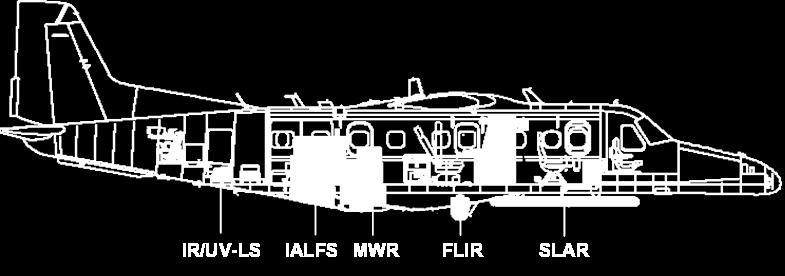


19 Improvement Airborne Multisensor SLAR MWR IR/UV-LS IALFS In Situ Sensors Infrared - thermal X- Band RADAR


20 Final Considerations The integrated analysis of remote sensing and oil drift models data presents an important decision tool for contingency actions. Long-term satellite monitoring allows the elaboration of more reliable environmental assesment studies and contingency plans.
21 Thank You Cristina Bentz R&D Center Energy and Sustainable Development Environment Assessment and Monitoring
Utilization of SAR and optical images/data for monitoring of the coastal environment
 Utilization of SAR and optical images/data for monitoring of the coastal environment What is an oil spill? Various petroleum products and their derivatives (petrol, kerosene, gasoline, diesel fuel, fuel,
OPERATIONAL SATELLITE MONITORING OF OIL SPILL POLLUTION IN THE SOUTHEASTERN BALTIC SEA: 1.5 YEARS EXPERIENCE
 US/EU-Baltic International Symposium May 23-25, 2006 Klaipeda, Lithuania OPERATIONAL SATELLITE MONITORING OF OIL SPILL POLLUTION IN THE SOUTHEASTERN BALTIC SEA: 1.5 YEARS EXPERIENCE 2006, Andrey G. Kostianoy
MOPED Monitoring of Oil Pollution using Earth Observation Data
 MOPED Monitoring of Oil Pollution using Earth Observation Data ESA/INTAS Project 06-1000025-9091 Earth Sciences and the Environment: Water Quality Contributors Valborg Byfield National Oceanograph Centre,
Low-Backscatter Ocean Features in Synthetic Aperture Radar Imagery
 P. CLEMENTE-COLÓN AND X-H. YAN Low-Backscatter Ocean Features in Synthetic Aperture Radar Imagery Pablo Clemente-Colón and Xiao-Hai Yan Many ocean surface signatures in synthetic aperture radar (SAR) imagery
Multisensor monitoring of Peter the Great Bay
 Multisensor monitoring of Peter the Great Bay Leonid Mitnik, Vyacheslav Dubina, Oleg Konstantinov and Vitaly Fischenko V.I. Il'ichev Pacific Oceanological Institute FEB RAS 43 Baltiyskaya St. 690041 Vladivostok,
CopernicusEU. the EU's Earth Observation Programme. Sara Zennaro Atre Delegation of the European Union to Japan
 Copernicus the EU's Earth Observation Programme Sara Zennaro Atre Delegation of the European Union to Japan Status Overview, Sept 2016 & Ocean Policies Seminar 4 October 2016 ollow us on: Copernicus EU
PREDICTION AND MONITORING OF OCEANIC DISASTERS USING MICROWAVE REMOTE SENSING TECHNIQUES
 PREDICTION AND MONITORING OF OCEANIC DISASTERS USING MICROWAVE REMOTE SENSING TECHNIQUES O P N Calla International Centre for Radio Science, OM NIWAS A-23, Shastri Nagar, Jodhpur-342 003 Abstract The disasters
Application of Wavelet Spectrum Analysis to Oil Spill Detection by Using Satellite Observation Data
 PAJ Oil Spill Symposium 2008 Application of Wavelet Spectrum Analysis to Oil Spill Detection by Using Satellite Observation Data February 21, 2008 Tokyo, Japan Masanao Hara Dr., VisionTech Inc. 1. Background
Use of Satellite Earth Observations, in situ data and numerical model capabilities for oil spill contingency. Page 1
 Use of Satellite Earth Observations, in situ data and numerical model capabilities for oil spill contingency Page 1 Oil spill service Page 2 Interest of Earth-Observation (EO) data for oil and gas companies
Currents and Objects
 SAR Marine Applications Currents and Objects Martin Gade Uni Hamburg, Institut für Meereskunde martin.gade@uni-hamburg.de SAR Maritime Applications Friday, 9 Sep, Morning: 1 - History & Basics Introduction
OCEAN SURFACE DRIFT BY WAVELET TRACKING USING ERS-2 AND ENVISAT SAR IMAGES
 OCEAN SURFACE DRIFT BY WAVELET TRACKING USING ERS-2 AND ENVISAT SAR IMAGES Antony K. Liu, Yunhe Zhao Ocean Sciences Branch, NASA Goddard Space Flight Center, Greenbelt, Maryland, USA Ming-Kuang Hsu Northern
DEMOSS. Title: Development of Marine Oil Spills/slicks Satellite monitoring System elements for the Black Sea, Caspian Sea and /Kara/Barents Seas
 DEMOSS Title: Development of Marine Oil Spills/slicks Satellite monitoring System elements for the Black Sea, Caspian Sea and /Kara/Barents Seas INTAS Thematic Call on Earth Sciences and Environment in
OIL POLLUTION IN THE SOUTHEASTERN BALTIC SEA IN
 Transport and Telecommunication, 2014, volume 15, no. 4, 285-294 Transport and Telecommunication Institute, Lomonosova 1, Riga, LV-1019, Latvia OIL POLLUTION IN THE SOUTHEASTERN BALTIC SEA IN 2009-2011
Monitoring Sea Ice with Space-borne Synthetic Aperture Radar
 Monitoring Sea Ice with Space-borne Synthetic Aperture Radar Torbjørn Eltoft UiT- the Arctic University of Norway CIRFA A Centre for Research-based Innovation cirfa.uit.no Sea ice & climate Some basic
Annex VI-1. Draft National Report on Ocean Remote Sensing in China. (Reviewed by the Second Meeting of NOWPAP WG4)
") UNEP/NOWPAP/CEARAC/WG4 2/9 Page1 Draft National Report on Ocean Remote Sensing in China (Reviewed by the Second Meeting of NOWPAP WG4) UNEP/NOWPAP/CEARAC/WG4 2/9 Page1 1. Status of RS utilization in marine
UNEP/NOWPAP/CEARAC/WG4 2/9 Page1 Draft National Report on Ocean Remote Sensing in China (Reviewed by the Second Meeting of NOWPAP WG4) UNEP/NOWPAP/CEARAC/WG4 2/9 Page1 1. Status of RS utilization in marine
Mapping Surface Oil Extent from the Deepwater Horizon Oil Spill Using ASCAT Backscatter
 Mapping Surface Oil Extent from the Deepwater Horizon Oil Spill Using ASCAT Backscatter Richard D. Lindsley and David G. Long Microwave Earth Remote Sensing Laboratory Brigham Young University Provo, UT
PETROLEUM HAZARDS MANAGEMENT BY GEOMATIC SYSTEMS
 PETROLEUM HAZARDS MANAGEMENT BY GEOMATIC SYSTEMS H. ASSILZADEH Spatial Information Technology & Engineering (SITE) Research Center Faculty of Engineering, Universiti Putra Malaysia, 43400 UPM, Serdang
SAR Raw Signal Simulation of Oil Slicks in Ocean Environments
 IEEE TRANSACTIONS ON GEOSCIENCE AND REMOTE SENSING, VOL. 40, NO. 9, SEPTEMBER 2002 1935 SAR Raw Signal Simulation of Oil Slicks in Ocean Environments Giorgio Franceschetti, Life Fellow, IEEE, Antonio Iodice,
GEOSC/METEO 597K Kevin Bowley Kaitlin Walsh
 GEOSC/METEO 597K Kevin Bowley Kaitlin Walsh Timeline of Satellites ERS-1 (1991-2000) NSCAT (1996) Envisat (2002) RADARSAT (2007) Seasat (1978) TOPEX/Poseidon (1992-2005) QuikSCAT (1999) Jason-2 (2008)
DUAL-POLARIZED COSMO SKYMED SAR DATA TO OBSERVE METALLIC TARGETS AT SEA
 DUAL-POLARIZED COSMO SKYMED SAR DATA TO OBSERVE METALLIC TARGETS AT SEA F. Nunziata, M. Montuori and M. Migliaccio Università degli Studi di Napoli Parthenope Dipartimento per le Tecnologie Centro Direzionale,
MERSEA Marine Environment and Security for the European Area
 MERSEA Marine Environment and Security for the European Area Development of a European system for operational monitoring and forecasting of the ocean physics, biogeochemistry, and ecosystems, on global
1 Introduction. 2 Wind dependent boundary conditions for oil slick detection. 2.1 Some theoretical aspects
 On C-Band SAR Based Oil Slick Detection in the Baltic Sea Markku Similä, István Heiler, Juha Karvonen, and Kimmo Kahma Finnish Institute of Marine Research (FIMR), PB 2, FIN-00561, Helsinki, Finland Email
Remote sensing of sea ice
 Remote sensing of sea ice Ice concentration/extent Age/type Drift Melting Thickness Christian Haas Remote Sensing Methods Passive: senses shortwave (visible), thermal (infrared) or microwave radiation
Remote Sensing I: Basics
 Remote Sensing I: Basics Kelly M. Brunt Earth System Science Interdisciplinary Center, University of Maryland Cryospheric Science Laboratory, Goddard Space Flight Center kelly.m.brunt@nasa.gov (Based on
Training Course on Radar & Optical RS, IES, Cēsis, Latvia, 5-9 September SAR Marine Applications. Practicals
 SAR Marine Applications Practicals Martin Gade Uni Hamburg, Institut für Meereskunde martin.gade@uni-hamburg.de SAR Marine Applications Friday, 9 Sep, Morning: 1 - History & Basics Introduction Radar/SAR
Radar manifestations of ship wakes in algae bloom zones
 Radar manifestations of ship wakes in algae bloom zones Marina I. Mityagina and Olga Yu. Lavrova Space Research Institute, Russian Academy of Sciences, 117997, Moscow, Russia, Profsoyuznaya str. 84/32
AUTOMATED DATA PROCESSING FOR MARITIME AND FLOODS APPLICATIONS
 YOUR HUB FOR GEOSPATIAL APPLICATIONS AUTOMATED DATA PROCESSING FOR MARITIME AND FLOODS APPLICATIONS Angelucci Maria, Daffina Filippo, Grandoni Domenico, Quattrociocchi Dino Automated Data Processing (Smart
RADAR PHOTO SMOOTH OCEAN LONG WAVES. Introduction
 Formation of radar and visible contrasts from the water surface RADAR PHOTO SMOOTH OCEAN SHORT WAVES Beal, 1994 LONG WAVES INTERNAL WAVES Introduction Satellite RAR and SAR have a high potential to study
Fjernmåling og modellering av oljesøl - på åpen sjø og i is
 Fjernmåling og modellering av oljesøl - på åpen sjø og i is Associate Professor, Camilla Brekke CIRFA (SFI) WP3 leader - Oil Spill Remote Sensing cirfa.uit.no What we are aiming for Detection & characterization
Instituto de Ingeniería, UNAM, México SPILL-SATCON, Satellite Constellation Mission Idea to Detect Oil Spills in Oceans
 SPILL-SATCON, Satellite Constellation Mission Idea to Detect Oil Spills in Oceans Dr. Esaú Vicente Vivas, Instituto de Ingeniería (II), UNAM, evv@unam.mx, C.Dr. Adán Espinoza Millán, Moscow State University,
J2.6 SONAR MEASUREMENTS IN THE GULF STREAM FRONT ON THE SOUTHEAST FLORIDA SHELF COORDINATED WITH TERRASAR-X SATELLITE OVERPASSES
 J2.6 SONAR MEASUREMENTS IN THE GULF STREAM FRONT ON THE SOUTHEAST FLORIDA SHELF COORDINATED WITH TERRASAR-X SATELLITE OVERPASSES Chris Maingot 1, Alexander Soloviev 1, Silvia Matt 1, Mikhail Gilman 1,
TOSCA RESULTS OVERVIEW
 TOSCA RESULTS OVERVIEW Almost 3 years after the project started, TOSCA has proved capable of improving oil spill tracking systems. TOSCA has brought updated knowledge on surface currents and noticeable
Arctic Observing Systems Challenges, New opportunities and Integration
 Arctic Observing Systems Challenges, New opportunities and Integration Japan Norway Arctic Science Week 03 June 2016 By Stein Sandven, NERSC Building an integrated Arctic Observing System Need to collect,
ASSESSMENT OF SAR OCEAN FEATURES USING OPTICAL AND MARINE SURVEY DATA
 ASSESSMENT OF SAR OCEAN FEATURES USING OPTICAL AND MARINE SURVEY DATA Medhavy Thankappan, Nadege Rollet, Craig J. H. Smith, Andrew Jones, Graham Logan and John Kennard Geoscience Australia, GPO Box 378,
Satellite-based Red-Tide Detection/Monitoring
 Satellite-based Detection/Monitoring Contents 1. Introduction - and Its Monitoring System 2. Detection Using Ocean Color Remote Sensing 3. Satellite-Based Monitoring in the Asian Coastal Seas Hiroshi KAWAMURA
EXPLOITING SUNGLINT SIGNATURES FROM MERIS AND MODIS IMAGERY IN COMBINATION TO SAR DATA TO DETECT OIL SLICKS
 EXPLOITING SUNGLINT SIGNATURES FROM MERIS AND MODIS IMAGERY IN COMBINATION TO SAR DATA TO DETECT OIL SLICKS M. Adamo 1, G. De Carolis 2, V. De Pasquale 2, and G. Pasquariello 2 1 Dept. of Physics, University
URSI-F Microwave Signatures Meeting 2010, Florence, Italy, October 4 8, Thomas Meissner Lucrezia Ricciardulli Frank Wentz
 URSI-F Microwave Signatures Meeting 2010, Florence, Italy, October 4 8, 2010 Wind Measurements from Active and Passive Microwave Sensors High Winds and Winds in Rain Thomas Meissner Lucrezia Ricciardulli
MARINE AND MARITIME SAR APPLICATIONS: COSMO-SKYMED FROM 1 ST TO 2 ND GENERATION
 MARINE AND MARITIME SAR APPLICATIONS: COSMO-SKYMED FROM 1 ST TO 2 ND GENERATION Maurizio Migliaccio, Ferdinando Nunziata, Andrea Buono Dipartimento di Ingegneria, Università degli Studi di Napoli Parthenope
Marine Situational Awareness and Environmental Monitoring using Satellites
 1 The Ny-ålesund Symposium 2013 The Changing Arctic Opportunity or Threat Marine Situational Awareness and Environmental Monitoring using Satellites Rolf Skatteboe President, Kongsberg Satellite Services
Operational ice charting in mid-latitudes using Near-Real-Time SAR imagery
 Operational ice charting in mid-latitudes using Near-Real-Time SAR imagery Sergey Vernyayev Ice Engineer ICEMAN.KZ Carles Debart Project Manager Energy, Environment and Security Yevgeniy Kadranov Ice charting
Environmental Data In Support of Search & Rescue Operations in the Central Mediterranean Sea
 Environmental Data In Support of Search & Rescue Operations in the Central Mediterranean Sea Dr. Eric Comerma (RPS ASA) eric.comerma@rpsgroup.com Cathleen Turner (RPS ASA) Prof. Aldo Drago (Univ. of Malta)
LESSON THREE Time, Temperature, Chlorophyll a Does sea surface temperature affect chlorophyll a concentrations?
 STUDENT PAGES LESSON THREE A partnership between California Current Ecosystem Long Term Ecological Research (CCE LTER) and Ocean Institute (OI) Beth Simmons, Education and Outreach Coordinator, CCE LTER,
MESOSCALE VARIABILITIES IN SEA SURFACE CURRENT FIELDS DERIVED THROUGH MULTI-SENSOR TRACKING OF SEA SURFACE FILMS
 MESOSCALE VARIABILITIES IN SEA SURFACE CURRENT FIELDS DERIVED THROUGH MULTI-SENSOR TRACKING OF SEA SURFACE FILMS Benjamin Seppke (1), Martin Gade (2), Leonie Dreschler-Fischer (2) (1) University of Hamburg,
SAR Training Course, MCST, Kalkara, Malta, November SAR Maritime Applications. Wind and Waves
 SAR Maritime Applications Wind and Waves Martin Gade Uni Hamburg, Institut für Meereskunde SAR Maritime Applications Thursday, 13 Nov.: 1 - History & Basics Introduction Radar/SAR History Basics Scatterometer
ESM 186 Environmental Remote Sensing and ESM 186 Lab Syllabus Winter 2012
 ESM 186 Environmental Remote Sensing and ESM 186 Lab Syllabus Winter 2012 Instructor: Susan Ustin (slustin@ucdavis.edu) Phone: 752-0621 Office: 233 Veihmeyer Hall and 115A, the Barn Office Hours: Tuesday
Satellite Oceanography and Applications 1: Introduction, SST, Ocean color
 Satellite Oceanography and Applications 1: Introduction, SST, Ocean color Ebenezer Nyadjro US Naval Research Lab RMU Summer Program (AUGUST 24-28, 2015) Objectives/Goals To know the basic methods of ocean
Marine Monitoring. The Copernicus Marine Service
 Marine The Copernicus Marine Service Why is the marine sector so important? Marine Blue Economy, 5 million jobs, gross added value almost 500bn/year 90% of international trade is maritime Half of the world's
PREDICTION OF OIL SPILL TRAJECTORY WITH THE MMD-JMA OIL SPILL MODEL
 PREDICTION OF OIL SPILL TRAJECTORY WITH THE MMD-JMA OIL SPILL MODEL Project Background Information MUHAMMAD HELMI ABDULLAH MALAYSIAN METEOROLOGICAL DEPARTMENT(MMD) MINISTRY OF SCIENCE, TECHNOLOGY AND INNOVATION
4. Verification and evaluation (monitoring) 4.1 Verification using visual information
 4.1 Verification using visual information") 4. Verification and evaluation (monitoring) 4.1 Verification using visual information Information on sightings of debris reported by ships is available on the web site of the Japanese government (http://www.kantei.go.jp/jp/singi/kaiyou/hyouryuu/senpaku.html).
4. Verification and evaluation (monitoring) 4.1 Verification using visual information Information on sightings of debris reported by ships is available on the web site of the Japanese government (http://www.kantei.go.jp/jp/singi/kaiyou/hyouryuu/senpaku.html).
5. TRACKING AND SURVEILLANCE
 5. Knowledge of the present position of spilled oil and an ability to predict its motion are essential components of any oil spill response. This function is known as surveillance and tracking and has
Opportunities for advanced Remote Sensing; an outsider s perspective
 Opportunities for advanced Remote Sensing; an outsider s perspective Ramon Hanssen Delft University of Technology 1 Starting questions Can we do more with the data we are already acquire? What s in stock
Copernicus Marine Environment Monitoring Service
 Copernicus Marine Environment Monitoring Service Mercator Ocean March 2017 Implemented by Entrusted to Mercator Ocean by the European Commission Cliquez et modifiez le titre French non-profit company Owned
Sharafat GADIMOVA Azerbaijan National Aerospace Agency (ANASA), Azerbaijan
, Azerbaijan") TOWARDS THE DEVELOPMENT OF AN OPERATIONAL STRATEGY FOR OIL SPILL DETECTION AND MONITORING IN THE CASPIAN SEA BASED UPON A TECHNICAL EVALUATION OF SATELLITE SAR OBSERVATIONS IN SOUTHEAST ASIA Sharafat GADIMOVA
TOWARDS THE DEVELOPMENT OF AN OPERATIONAL STRATEGY FOR OIL SPILL DETECTION AND MONITORING IN THE CASPIAN SEA BASED UPON A TECHNICAL EVALUATION OF SATELLITE SAR OBSERVATIONS IN SOUTHEAST ASIA Sharafat GADIMOVA
EUMETSAT STATUS AND PLANS
 1 EUM/TSS/VWG/15/826793 07/10/2015 EUMETSAT STATUS AND PLANS François Montagner, Marine Applications Manager, EUMETSAT WMO Polar Space Task Group 5 5-7 October 2015, DLR, Oberpfaffenhofen PSTG Strategic
Training Course on Radar & Optical RS, IES, Cēsis, Latvia, 5-9 September SAR Marine Applications. Wind and Waves
 SAR Marine Applications Wind and Waves Martin Gade Uni Hamburg, Institut für Meereskunde martin.gade@uni-hamburg.de SAR Marine Applications Friday, 9 Sep, Morning: 1 - History & Basics Introduction Radar/SAR
EO-Based Ice and Iceberg Monitoring in Support of Offshore Engineering Design and Tactical Operations
 EO-Based Ice and Iceberg Monitoring in Support of Offshore Engineering Design and Tactical Operations Desmond Power, C-CORE ESA Industry Workshop on Satellite EO for the Oil and Gas Sector Overview Operations
Oceanology International, London, March 2012 Ocean Observation & Forecasting programme. An African Network of Offshore Real-Time Metocean Stations
 Oceanology International, London, March 2012 Ocean Observation & Forecasting programme An African Network of Offshore Real-Time Metocean Stations Valérie QUINIOU-RAMUS, Rémi ESTIVAL (TOTAL S.A., EP/DEV/TEC/GEO)
COMPLEX MONITORING OF OIL POLLUTION IN THE BALTIC, BLACK AND CASPIAN SEAS
 COMPLEX MONITORING OF OIL POLLUTION IN THE BALTIC, BLACK AND CASPIAN SEAS Kostianoy A.G. (1), Lavrova O.Yu. (2), Mityagina M.I. (2), Bocharova T.Yu. (2), Litovchenko K.Ts. (3), Lebedev S.A. (4, 5), Stanichny
Davida Streett NOAA/NESDIS. NESDIS Satellite Analysis Branch Hazard Mitigation Programs
 ESA 2010 Oil Davida Streett NOAA/NESDIS NESDIS Satellite Analysis Branch Hazard Mitigation Programs Operational 24 x 7 x 365 Fire and Smoke Precipitation Tropical Storms/Hurricanes Oil/Marine Pollution
HY-2A Satellite User s Guide
 National Satellite Ocean Application Service 2013-5-16 Document Change Record Revision Date Changed Pages/Paragraphs Edit Description i Contents 1 Introduction to HY-2 Satellite... 1 2 HY-2 satellite data
Remote Sensing and GIS. Microwave Remote Sensing and its Applications
 Subject Paper No and Title Module No and Title Module Tag Geology Remote Sensing and GIS Microwave Remote Sensing and its Applications RS & GIS XVII Principal Investigator Co-Principal Investigator Co-Principal
Oceanic Eddies in the VOCALS Region of the Southeast Pacific Ocean
 Oceanic Eddies in the VOCALS Region of the Southeast Pacific Ocean Outline: Overview of VOCALS Dudley B. Chelton Oregon State University Overview of the oceanographic component of VOCALS Preliminary analysis
NOAA Unmanned Aircraft Systems (UAS) Program Overview
 Program Overview") NOAA Unmanned Aircraft Systems (UAS) Program Overview AUVSI Pathfinder Symposium March 2015 Presented by: John Walker Cherokee Nation Technologies in support of NOAA UAS Program Office NOAA UAS Program
NOAA Unmanned Aircraft Systems (UAS) Program Overview AUVSI Pathfinder Symposium March 2015 Presented by: John Walker Cherokee Nation Technologies in support of NOAA UAS Program Office NOAA UAS Program
ASAR practical training session
 ASAR practical training session Dr. Fabrice Collard and Dr. Vincent Kerbaol, BOOST Technologies, Brest, France Prof. Johnny Johannessen NERSC, Bergen, Norway 2 Presentation of the company The activities
Surface Anomalies Prior to Earthquakes
 Surface Anomalies Prior to Earthquakes Habibeh Valizadeh, Shattri B. Mansor Husaini Omar and Farid Azad Department of Civil Engineering Universiti Putra Malaysia Serdang, Selangor Malaysia shattri@eng.upm.edu.my
Update on SCOPE-Nowcasting Pilot Project Real Time Ocean Products Suman Goyal Scientist-E
 Update on SCOPE-Nowcasting Pilot Project Real Time Ocean Products Suman Goyal Scientist-E 19-22 Nov 2013 SCOPE-Nowcasting-1 Agenda Item 5 Pilot Projects Overview Users /Clients User requirements Product
Microwave Remote Sensing of Soil Moisture. Y.S. Rao CSRE, IIT, Bombay
 Microwave Remote Sensing of Soil Moisture Y.S. Rao CSRE, IIT, Bombay Soil Moisture (SM) Agriculture Hydrology Meteorology Measurement Techniques Survey of methods for soil moisture determination, Water
The Wind-Wave Tank of Univ Hamburg
 The Wind-Wave Tank of Univ Hamburg An Overview of Four Decades of Studies of Air-Sea Interactions ГАДЕ, Мартин Хорстович (aka Martin Gade) Institut für Meereskunde, Universität Hamburg, Германия Universität
Eddies in the Southern California Bight
 HOME INTRODUCTION BIOLOGY POLLUTION CREDITS/LINKS Circulation in the Southern California Bight Scroll down this page to learn about current circulation in the Southern California Bight, or jump directly
SAR Remote Sensing of Nonlinear Internal Waves in the South China Sea
 SAR Remote Sensing of Nonlinear Internal Waves in the South China Sea Yunhe Zhao Caelum Research Corporation 1700 Research Boulevard, Suite 250 Rockville, MD 20850 Phone: (301) 614-5883 Fax: (301) 614-5644
Monitoring of Arctic Conditions from a Virtual Constellation of Synthetic Aperture Radar Satellites
 DISTRIBUTION STATEMENT A. Approved for public release; distribution is unlimited. Monitoring of Arctic Conditions from a Virtual Constellation of Synthetic Aperture Radar Satellites Hans C. Graber RSMAS
Remote sensing of marine oil spills from airborne platforms using multi-sensor systems
 Water Pollution VIII: Modelling, Monitoring and Management 347 Remote sensing of marine oil spills from airborne platforms using multi-sensor systems N. Robbe & T. Hengstermann OPTIMARE Sensorsysteme AG,
Monitoring the coastal ocean: from local to regional
 Monitoring the coastal ocean: from local to regional Luísa Bastos University of Porto / CIIMAR RAIA partners Ocean monitoring To answer key societal and scientific challenges navigation safety, fisheries,
REGIONAL MARINE POLLUTION EMERGENCY RESPONSE CENTRE FOR THE MEDITERRANEAN SEA (REMPEC) MEDITERRANEAN ACTION PLAN
 MEDITERRANEAN ACTION PLAN") REGIONAL MARINE POLLUTION EMERGENCY RESPONSE CENTRE FOR THE MEDITERRANEAN SEA (REMPEC) MEDITERRANEAN ACTION PLAN AERIAL AND SATELLITE SURVEILLANCE OF OPERATIONAL POLLUTION WITHIN THE ADRIATIC SEA: A COMPARATIVE
REGIONAL MARINE POLLUTION EMERGENCY RESPONSE CENTRE FOR THE MEDITERRANEAN SEA (REMPEC) MEDITERRANEAN ACTION PLAN AERIAL AND SATELLITE SURVEILLANCE OF OPERATIONAL POLLUTION WITHIN THE ADRIATIC SEA: A COMPARATIVE
ABSTRACT 1. INTRODUCTION
 Multi-Sensor Satellite Survey of the Surface Oil Pollution in the Caspian Sea Marina I. Mityagina and Olga Yu. Lavrova Space Research Institute, Russian Academy of Sciences, 117997, Moscow, Russia, Profsoyuznaya
EVALUATION OF WINDSAT SURFACE WIND DATA AND ITS IMPACT ON OCEAN SURFACE WIND ANALYSES AND NUMERICAL WEATHER PREDICTION
 5.8 EVALUATION OF WINDSAT SURFACE WIND DATA AND ITS IMPACT ON OCEAN SURFACE WIND ANALYSES AND NUMERICAL WEATHER PREDICTION Robert Atlas* NOAA/Atlantic Oceanographic and Meteorological Laboratory, Miami,
A Facility for Producing Consistent Remotely Sensed Biophysical Data Products of Australia
 TERRESTRIAL ECOSYSTEM RESEARCH NETWORK - AusCover - A Facility for Producing Consistent Remotely Sensed Biophysical Data Products of Australia June, 2011 Mervyn Lynch Professor of Remote Sensing Curtin
K&C Phase 4 Status report. Ice Sheet Monitoring using ALOS-2. University of California, Irvine 2 JPL
 K&C Phase 4 Status report Ice Sheet Monitoring using ALOS-2 Bernd Scheuchl 1, Jeremie Mouginot 1, Eric Rignot 1,2 1 University of California, Irvine 2 JPL Science Team meeting #24 Tokyo, Japan, January
Wind, Slick, and Fishing Boat Observations with Radarsat ScanSAR
 Wind, Slick, and Fishing Boat Observations with Radarsat ScanSAR Jim Gower and Simon Skey The wide swath (45 km) of ScanSAR (synthetic aperture radar) images provides a greater opportunity for imaging
SATELLITE DATA COLLECTION BY THE UPRM-TCESS SPACE INFORMATION LABORATORY
 SATELLITE DATA COLLECTION BY THE UPRM-TCESS SPACE INFORMATION LABORATORY Visita a la Estación De Satélites De UPRM En el CID 16 sep. 4:30 pm Nos reuniremos al frente del CID. CID L-BAND ANTENNA Orbview
Manifestation Specifics of Hydrodynamic Processes in Satellite Images of Intense Phytoplankton Bloom Areas
 ISSN 1-4338, Izvestiya, Atmospheric and Oceanic Physics, 216, Vol. 2, No. 9, pp. 974 987. Pleiades Publishing, Ltd., 216. Original Russian Text O.Yu. Lavrova, M.I. Mityagina, 216, published in Issledovanie
AOSN Monterey Bay Experiment: Creating Sustainable Ocean Observation/Prediction Systems
 AOSN Monterey Bay Experiment: Creating Sustainable Ocean Observation/Prediction Systems AOSN II Objectives: To design and build an adaptive coupled observation/modeling system. The system should be sustainable
The GMES/MyOcean Marine Service and its applications
 The GMES/MyOcean Marine Service and its applications P.Y. Le Traon (Ifremer) P. Bahurel (Mercator Ocean) First BreTel Workshop May 31st, 2012 - St Malo Outline The GMES Marine Service and MyOcean What
Use of in-situ and remote sensors, sampling, and systems for assessing extent, fate, impact, and mitigation of oil and dispersants
 Use of in-situ and remote sensors, sampling, and systems for assessing extent, fate, impact, and mitigation of oil and dispersants Gustavo Jorge Goni (NOAA/AOML, Miami, FL) Gustavo.Goni@noaa.gov and the
Copernicus Today and Tomorrow GEO Week Group on Earth Observation Geneva, 16 January 2014 The Copernicus Space Infrastructure
 Copernicus Today and Tomorrow GEO Week Group on Earth Observation Geneva, 16 January 2014 The Copernicus Space Infrastructure Thomas Beer, Policy Coordinator, Copernicus Space Office, ESA-ESRIN, Frascati
Astrid Bracher PHYTOOPTICS group, Climate Sciences, AWI & IUP, University Bremen
 Breakout session "Hyperspectral science and applications for shelf and open ocean processes" Hyperspectral ocean color imagery and applications to studies of phytoplankton ecology Astrid Bracher PHYTOOPTICS
Detecting Oil Spills in the Offshore Nile Delta Coast Using Image Processing of ERS SAR Data
 Proceedings of the 2nd WSEAS International Conference on Remote Sensing, Tenerife, Canary Islands, Spain, December 16-18, 2006 20 Detecting Oil Spills in the Offshore Nile Delta Coast Using Image Processing
Reminder: All answers MUST GO ON ANSWER SHEET! Answers recorded in the exam booklet will not count.
 Reminder: All answers MUST GO ON ANSWER SHEET! Answers recorded in the exam booklet will not count. 1. Identify the following acronyms; compare these platform types; provide situations where one platform
The known requirements for Arctic climate services
 The known requirements for Arctic climate services based on findings described in STT White paper 8/2015 Johanna Ekman / EC PHORS STT Regional drivers The Arctic region is home to almost four million people
Fri. Apr. 06, Map Projections Environmental Applications. Reading: Finish Chapter 9 ( Environmental Remote Sensing )
") Fri. Apr. 06, 2018 Map Projections Environmental Applications Reading: Finish Chapter 9 ( Environmental Remote Sensing ) Once again -- Satellites old but principles still apply Skim Sabins Chapter 10.
Fri. Apr. 06, 2018 Map Projections Environmental Applications Reading: Finish Chapter 9 ( Environmental Remote Sensing ) Once again -- Satellites old but principles still apply Skim Sabins Chapter 10.
MARINE MONITORING OF THE SOUTH- AND EAST CHINA SEAS BASED ON ENVISAT ASAR
 MARINE MONITORING OF THE SOUTH- AND EAST CHINA SEAS BASED ON ENVISAT ASAR Knut-Frode Dagestad (1), Johnny Johannessen (1), Vincent Kerbaol (2), Fabrice Collard (2), Vladimir Kudryavtsev (3, 4), Dmitry
Assimilation of Snow and Ice Data (Incomplete list)
") Assimilation of Snow and Ice Data (Incomplete list) Snow/ice Sea ice motion (sat): experimental, climate model Sea ice extent (sat): operational, U.S. Navy PIPs model; Canada; others? Sea ice concentration
Assimilation of Snow and Ice Data (Incomplete list) Snow/ice Sea ice motion (sat): experimental, climate model Sea ice extent (sat): operational, U.S. Navy PIPs model; Canada; others? Sea ice concentration
NOAA Great Lakes CoastWatch Program
 Great Lakes Workshop Series on Remote Sensing of Water Quality May 7-8, 2014 NOAA GLERL, 4840 South State Rd, Ann Arbor, MI NOAA Great Lakes CoastWatch Program CoastWatch is a nationwide National Oceanic
The 3 rd NOWPAP Joint Training Courses on Remote Sensing Data Analysis. Vladivostok, Russia, 11 October 2011
 The 3 rd NOWPAP Joint Training Courses on Remote Sensing Data Analysis Vladivostok, Russia, 11 October 2011 Monitoring of oil pollution with the use of satellite imagery Leonid M. Mitnik V.I. Il'ichev
E x a m p l e s o f t o o l s f o r s e a s i t u a t i o n a l a w a r e n e s s u s i n g C M E M S d a t a. Copernicus EU
 E x a m p l e s o f t o o l s f o r s e a s i t u a t i o n a l a w a r e n e s s u s i n g C M E M S d a t a Copernicus EU Copernicus EU Copernicus EU www.copernicus.eu S e a S i t u a t i o n a l A w
Introduction to RS Lecture 2. NR401 Dr. Avik Bhattacharya 1
 Introduction to RS Lecture 2 NR401 Dr. Avik Bhattacharya 1 This course is about electromagnetic energy sensors other types of remote sensing such as geophysical will be disregarded. For proper analysis
GEOG Lecture 8. Orbits, scale and trade-offs
 Environmental Remote Sensing GEOG 2021 Lecture 8 Orbits, scale and trade-offs Orbits revisit Orbits geostationary (36 000 km altitude) polar orbiting (200-1000 km altitude) Orbits revisit Orbits geostationary
SAWS: Met-Ocean Data & Infrastructure in Support of Industry, Research & Public Good. South Africa-Norway Science Week, 2016
 SAWS: Met-Ocean Data & Infrastructure in Support of Industry, Research & Public Good South Africa-Norway Science Week, 2016 Marc de Vos, November 2016 South Africa: Context http://learn.mindset.co.za/sites/default/files/resourcelib/e
Validation of sea ice concentration in the myocean Arctic Monitoring and Forecasting Centre 1
 Note No. 12/2010 oceanography, remote sensing Oslo, August 9, 2010 Validation of sea ice concentration in the myocean Arctic Monitoring and Forecasting Centre 1 Arne Melsom 1 This document contains hyperlinks
Surface WAter Microwave Product Series [SWAMPS]
![Surface WAter Microwave Product Series [SWAMPS]](/thumbs/87/97403550.jpg "Surface WAter Microwave Product Series [SWAMPS]") Surface WAter Microwave Product Series [SWAMPS] Version 3.2 Release Date: May 01 2018 Contact Information: Kyle McDonald, Principal Investigator: kmcdonald2@ccny.cuny.edu Kat Jensen: kjensen@ccny.cuny.edu
Surface WAter Microwave Product Series [SWAMPS] Version 3.2 Release Date: May 01 2018 Contact Information: Kyle McDonald, Principal Investigator: kmcdonald2@ccny.cuny.edu Kat Jensen: kjensen@ccny.cuny.edu