Marine Situational Awareness and Environmental Monitoring using Satellites
|
|
|
- Anabel Doyle
- 6 years ago
- Views:
Transcription

1 1 The Ny-ålesund Symposium 2013 The Changing Arctic Opportunity or Threat Marine Situational Awareness and Environmental Monitoring using Satellites Rolf Skatteboe President, Kongsberg Satellite Services Ny-Ålesund, Svalbard May 27 29, 2013


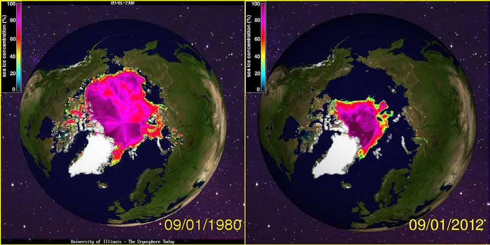
2 Increased activities in the Arctic Transport Oil and Gas Fishery Change in the climate is observed Increased demand for monitoring and surveillance Satellites are an important / 2 / 31-May-13 WORLD CLASS through people, technology and dedication


3 Polar vs Geostationar Satellites / 3 / 31-May-13 / 3 / WORLD CLASS through people, technology and dedication WORLD CLASS through people, technology and dedication


4 First weather satellite image Only 53 years ago


5 Optical Satellites Coverage vs Resolution / 5 / 31-May-13 WORLD CLASS through people, technology and dedication


6 Dronning Maud Land Antarctica Finmark Northern Norway


7 The Greenland inland ice is shrinking / 7 / 31-May-13 WORLD CLASS through people, technology and dedication

8 Radar Satellites. Through clouds and darkness First Cosmo-Skymed image processed by KSAT 18. January 2013 Copyright raw data ASI, 2013 / 8 / 2,5 km WORLD CLASS through people, technology and dedication

 and")
9 Metocean: Satellite derived high resolution winds Surface (L) and Atmospheric (R) winds


 service contracts for over a decade Lead")

10 Norway long history spaceborne maritime surveillance Norway started already in 1984 focusing on maritime applications and radar satellites Vast ocean areas combined with darkness demanded new surveillance technology Oil-spill and vessel detection service developed in Norway In cooperation with national authority End-user involvement from the start instrumental to obtain success Operational oil-spill (including vessel detection) service contracts for over a decade Lead partner in today s Pan-European oil spill detection service Launched AISSat-1 in July 2010 / 10 / 31-May-13 / 10 / WORLD CLASS through people, technology and dedication
 Nordøst passasjen delvis åpen (blue line).")

11 Focus Northern Areas Political National Governmental strategy International focus September 2007 Nordvest passasjen åpen (orange line) Nordøst passasjen delvis åpen (blue line). Commercial Fisheries Shipping Offshore oil & gas Environment & climate Challenges due to weather, light and data availability Satellite+traditional technology Independent of light & weather Operational services exist Establish area knowledge base / 11 / 31-May-13 WORLD CLASS through people, technology and dedication
 Aerial photo, Coastal Directorate (over right) / 12 /")
12 Example Oil Spill Detection Discharge from a Norwegian offshore oil installation Autumn 2004 Radarsat-1 SAR image (over left) Aerial photo, Coastal Directorate (over right) / 12 / 31-May-13

13 Service but always not real pollution
14 Source identification and the evidence


15 Vessel detection Satellite tradeoff: Coverage vs resolution 300 km swath 50 m resolution 50 km swath 8 m resolution 20 km swath optical 0,5 m resolution RADARSAT SAR Processed by KSAT, 2009 / 15 / 31-May-13 WORLD CLASS through people, technology and dedication


16 The first Norwegian Satellite AISSat-1 / 16 / 31-May-13 WORLD CLASS through people, technology and dedication


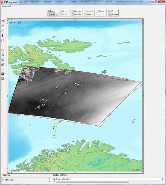
17 A Month of Winter or Summer 01/ /2011
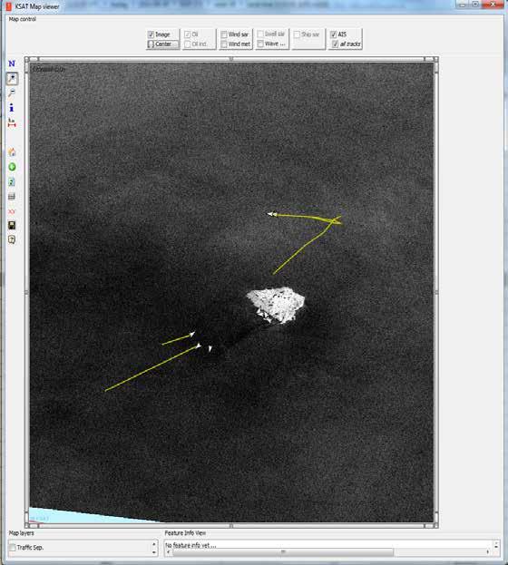
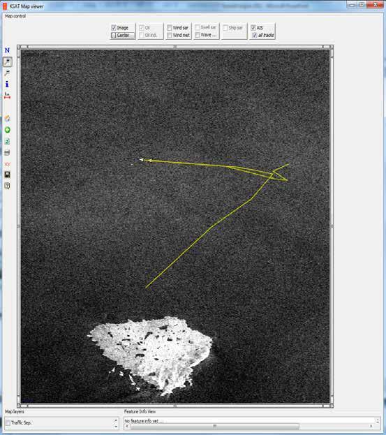
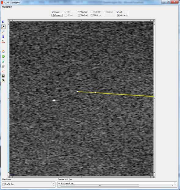
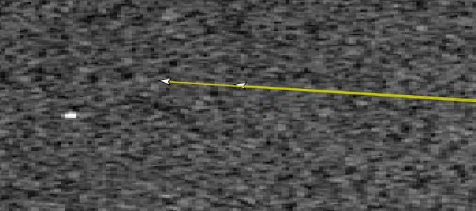
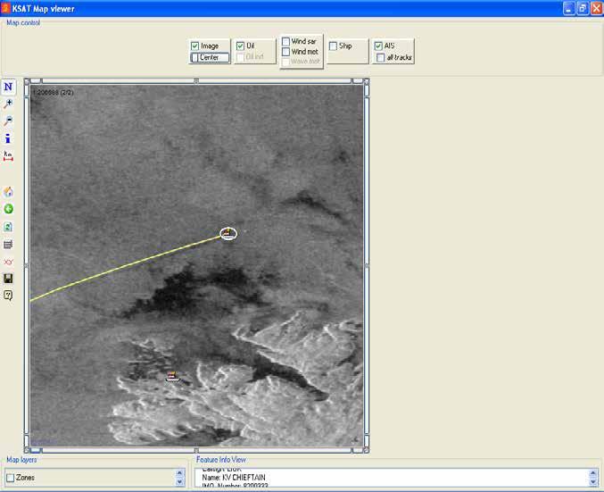
18 Vessel detection, tracking and identification / 18 / 31-May-13


19 Ship position detection Smutthullet, august 1996 KONGSBERG May 31, 2013 Operational near real-time service Detection and early warning of ship positions Customers: Coast Guard/Defence Fisheries authorities 1997-: Norwegian Defence/Coast Guard operational user KSAT data delivery 2004-: KSAT service International deliveries National demonstrations and user expansion Coordination of satellites and other surveillance resources Aircraft Coastal radar AIS, VMS Copyright RADARSAT data Canadian Space Agency/Agence spatiale canadienne, Received, processed and distributed by 19 TSS.

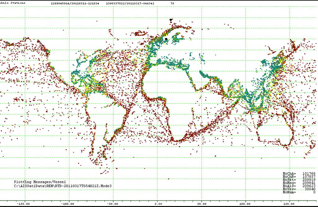
20 Global activity 20
21 21


22 Satellite data for operations in ice Bilder som supplement til iskart Utfordring mhp kommunikasjon / 22 / 31-May-13


23 Ship routing in ice waters Planned route through the ice 6 hours Actual route around the ice 3 hours


24 Detection and tracking of icebergs in Arctic Possible treats to activities Offshore oil & gas Commercial shipping Challenge Identify the target Discriminate iceberg vs ship Tracking of the ice berg / 24 / 31-May-13 WORLD CLASS through people, technology and dedication
25 Space on the political agenda Large EU initiatives: Galileo and Copernicus Norway is currently taking part in both programmes through 2013 under the European Economic Area mechanism. White paper to the parliament on Space Activity Current Norwegian Position from the Minister of Trade and Industry Use of space shall benefit the society. That s why the activity in Norway is referred to as space economics rather than just space activity Norway has about 2% of the clobal space economy. The space activity is then located in between fish farming and oil and gas relative to the share of global turnover Norsk Romsenter
26 Future perspectives Arctic importance increase satellite technology for management, environment, operations safety and security Norways ambitions to be the lead regional provider Utilise ground segment, user relationships and existing operational service capabilities Services - status Existing services improve (oil spill, vessel detection) New services establish (ice, cryosphere, coastal zone) Services - approach Integrated multisensor, multiuser services EO (SAR) data and auxiliary data sources Cooperation with R&D institutions Define needs, provide data, coordinate activities/projects Access to new/improved methods for services / 26 / 31-May-13 WORLD CLASS through people, technology and dedication

27 kongsberg.com / 27 / WORLD CLASS through people, technology and dedication
Copernicus Today and Tomorrow GEO Week Group on Earth Observation Geneva, 16 January 2014 The Copernicus Space Infrastructure
 Copernicus Today and Tomorrow GEO Week Group on Earth Observation Geneva, 16 January 2014 The Copernicus Space Infrastructure Thomas Beer, Policy Coordinator, Copernicus Space Office, ESA-ESRIN, Frascati
CopernicusEU. the EU's Earth Observation Programme. Sara Zennaro Atre Delegation of the European Union to Japan
 Copernicus the EU's Earth Observation Programme Sara Zennaro Atre Delegation of the European Union to Japan Status Overview, Sept 2016 & Ocean Policies Seminar 4 October 2016 ollow us on: Copernicus EU
Weather and ice information as a tool for arctic marine and offshore services
 Weather and ice information as a tool for arctic marine and offshore services World Meteorological Organization Executive Council Panel of Experts on Polar Observations, Research and Services President
National Satellite Data Centre and Finnish Sentinel Collaborative Ground Segment. Jyri Heilimo Finnish Meteorological Instute
 National Satellite Data Centre and Finnish Sentinel Collaborative Ground Segment Jyri Heilimo Finnish Meteorological Instute Sodankylä National Satellite Data Centre National satellite data centre providing
Sentinel-1 Mission Status
 Sentinel-1 Mission Status Pierre Potin, Sentinel-1 Mission Manager, ESA Luca Martino, Technical Support Engineer, ESA... and the Sentinel-1 operations team PSTG SAR Coordination Working Group 14 December
Monitoring Sea Ice with Space-borne Synthetic Aperture Radar
 Monitoring Sea Ice with Space-borne Synthetic Aperture Radar Torbjørn Eltoft UiT- the Arctic University of Norway CIRFA A Centre for Research-based Innovation cirfa.uit.no Sea ice & climate Some basic
E x a m p l e s o f t o o l s f o r s e a s i t u a t i o n a l a w a r e n e s s u s i n g C M E M S d a t a. Copernicus EU
 E x a m p l e s o f t o o l s f o r s e a s i t u a t i o n a l a w a r e n e s s u s i n g C M E M S d a t a Copernicus EU Copernicus EU Copernicus EU www.copernicus.eu S e a S i t u a t i o n a l A w
Ice surveys, meteorological and oceanographic data What is available and up-to-date?
 Ice surveys, meteorological and oceanographic data What is available and up-to-date? Leader of the Norwegian Ice Service +47 77 62 13 15 - nick.hughes@met.no Norwegian Meteorological Institute met.no 1
The known requirements for Arctic climate services
 The known requirements for Arctic climate services based on findings described in STT White paper 8/2015 Johanna Ekman / EC PHORS STT Regional drivers The Arctic region is home to almost four million people
HF radarcontribution to South Africa Blue Economy
 HF radarcontribution to South Africa Blue Economy Anton G Kjelaas1, Andres Alonso- Martirena2, Chad Whelan3 South Africa- Norway Science Week 2016 Oct 31- Nov 4 2016 1 2 3 BLUE ECONOMY Sustainable use
NGGPS Community Sea Ice Model Recommendation Workshop. Rebecca Heim / Gene Petrescu NOAA/NWS Alaska Region
 NGGPS Community Sea Ice Model Recommendation Workshop Rebecca Heim / Gene Petrescu NOAA/NWS Alaska Region NWS Alaska Region Ice Services Excerpts from NOAAs Arctic Action Plan NOAA s National Weather Service
Space for the Arctic
 Space for the Arctic Bo Andersen Norwegian Polar Committee & Norwegian Space Centre 1 My Mantra for Space Few, if any of the global challenges can be resolved by space alone But Few, if any can be resolved
Operational ice charting in mid-latitudes using Near-Real-Time SAR imagery
 Operational ice charting in mid-latitudes using Near-Real-Time SAR imagery Sergey Vernyayev Ice Engineer ICEMAN.KZ Carles Debart Project Manager Energy, Environment and Security Yevgeniy Kadranov Ice charting
CANADIAN HYDROGRAPHIC SERVICE & OCEANOGRAPHIC SERVICES
 CANADIAN HYDROGRAPHIC SERVICE & OCEANOGRAPHIC SERVICES Presentation to Warming of the North Conference Ottawa, March 2 nd, 2015 Denis Hains, Director General & Hydrographer General of Canada TIP OF THE
UN COPUOS 52 nd session of the Scientific and Technical Subcommittee. COPERNICUS - an European Achievement. S. Jutz Head, ESA Copernicus Space Office
 UN COPUOS 52 nd session of the Scientific and Technical Subcommittee COPERNICUS - an European Achievement S. Jutz Head, ESA Copernicus Space Office 11 Feb 2015, Vienna 1 2 What is Copernicus? European
ALASKA DEEP-DRAFT ARCTIC PORT EVALUATION
 ALASKA DEEP-DRAFT ARCTIC PORT EVALUATION Joint Study of Federal and State June 20, 2012 Opportunity and Constraint Warming of Arctic region is leading to new maritime opportunities. Thawing of permafrost
Challenges for SAR operations in the Barents Sea. Tor Einar Berg, Beate Kvamstad
 Challenges for SAR operations in the Barents Sea Tor Einar Berg, Beate Kvamstad MARINTEK, Trondheim, Norway, Tor.E.Berg@marintek.sintef.no This paper gives a brief overview of challenges in SAR operations
Opportunities for advanced Remote Sensing; an outsider s perspective
 Opportunities for advanced Remote Sensing; an outsider s perspective Ramon Hanssen Delft University of Technology 1 Starting questions Can we do more with the data we are already acquire? What s in stock
AUTOMATED DATA PROCESSING FOR MARITIME AND FLOODS APPLICATIONS
 YOUR HUB FOR GEOSPATIAL APPLICATIONS AUTOMATED DATA PROCESSING FOR MARITIME AND FLOODS APPLICATIONS Angelucci Maria, Daffina Filippo, Grandoni Domenico, Quattrociocchi Dino Automated Data Processing (Smart
Copernicus Space Component Status & Evolution
 Copernicus Space Component Status & Evolution ESCAP, Bangkok 09 October 2017 Simon Jutz Head of the ESA Copernicus Space Office Directorate of Earth Observation Programmes 28 satellites in development
Wave processes in Arctic Seas, observed from TerraSAR-X
 DISTRIBUTION STATEMENT A. Approved for public release; distribution is unlimited. Wave processes in Arctic Seas, observed from TerraSAR-X Susanne Lehner DLR German Air and Space Research Center Earth Observation
Infrastructure monitoring using SAR interferometry
 Infrastructure monitoring using SAR interferometry Hossein Nahavandchi Roghayeh Shamshiri Norwegian University of Science and Technology (NTNU), Department of Civil and Environmental Engineering Geodesy
Polar. Thematic Exploitation Platform. Andrew Fleming, BAS/Polar View ESRIN, 14 th October 2015
 Polar Thematic Exploitation Platform Andrew Fleming, BAS/Polar View ESRIN, 14 th October 2015 Why a Polar TEP? Polar regions play an important role in regulating and driving the global climate & experiencing
A BRIEF INTRODUCTION TO COPERNICUS AND CAMS
 A BRIEF INTRODUCTION TO COPERNICUS AND CAMS Juan Garcés de Marcilla Director of Copernicus Services European Centre for Medium-Range Weather Forecasts Copernicus EU Copernicus EU Copernicus EU www.copernicus.eu
Marine Monitoring. The Copernicus Marine Service
 Marine The Copernicus Marine Service Why is the marine sector so important? Marine Blue Economy, 5 million jobs, gross added value almost 500bn/year 90% of international trade is maritime Half of the world's
European Space Agency
 Guidelines - Guidelines how/when to interact during the WebEx session: - Due to the number of attendees, please keep always your webcam and microphone switched-off - You can use anytime the chat to all
EO-Based Ice and Iceberg Monitoring in Support of Offshore Engineering Design and Tactical Operations
 EO-Based Ice and Iceberg Monitoring in Support of Offshore Engineering Design and Tactical Operations Desmond Power, C-CORE ESA Industry Workshop on Satellite EO for the Oil and Gas Sector Overview Operations
Iceland and the Arctic: The Politics of Territoriality. Valur Ingimundaron Professor of Contemporary History, University of Iceland
 Iceland and the Arctic: The Politics of Territoriality Valur Ingimundaron Professor of Contemporary History, University of Iceland Drivers of Icelandic Arctic Policies Geostrategic Position Economic Interests
FINDINGS OF THE ARCTIC METEOROLOGY SUMMIT
 FINDINGS OF THE ARCTIC METEOROLOGY SUMMIT 2018 WWW.FMI.FI CHAIR S SUMMARY: 1 2 3 We need to be curious to explore the known unknowns. Meteorology is an elemental part of international collaboration in
Meteorological Cooperation in the Arctic. Perspectives from Finland
 Meteorological Cooperation in the Arctic Perspectives from Finland Improving public safety, better data coverage, enhancing arctic climate science VAWS Webinar Series Fairbanks, Alaska May 10th 2017 Finland
Sentinel-1 Mission Status
 Sentinel-1 Mission Status Pierre Potin, Sentinel-1 Mission Manager 5TH GEOGLAM RAPP Workshop 16-17 May 2017, ESRIN Sentinel-1: Copernicus radar imaging mission for ocean, land, emergency Part of the Copernicus
Development of an International Arctic Observations Assessment Framework
 Development of an International Arctic Observations Assessment Framework Dr. Steven Lev, Dr. Jason Gallo Briefing for the Sustaining Arctic Observing Networks (SAON) April 7, 2017 International Partners
CX Debate Topic Analysis
 CX Debate Topic Analysis Larry McCarty lmac916@gmail.com or larry.mc@excite.com Resolved: The United States federal government should substantially increase its nonmilitary exploration and/or development
HY-2A Satellite User s Guide
 National Satellite Ocean Application Service 2013-5-16 Document Change Record Revision Date Changed Pages/Paragraphs Edit Description i Contents 1 Introduction to HY-2 Satellite... 1 2 HY-2 satellite data
CONFERENCE STATEMENT
 CONFERENCE STATEMENT We, the elected representatives from Canada, Denmark/Greenland, Finland, Iceland, Norway, Russia, Sweden and the United States of America; In collaboration with the indigenous peoples
Mersea Oil Spill Drift Forecast Demonstrations in TOP2
 Mersea Oil Spill Drift Forecast Demonstrations in TOP2 Bruce Hackett (met.no), George Zodiatis (UCY), Pierre Daniel (MeteoFrance), Francois Parthiot (Cedre) Presented at 3rd Mersea Plenary Meeting, CNR,
Validation of sea ice concentration in the myocean Arctic Monitoring and Forecasting Centre 1
 Note No. 12/2010 oceanography, remote sensing Oslo, August 9, 2010 Validation of sea ice concentration in the myocean Arctic Monitoring and Forecasting Centre 1 Arne Melsom 1 This document contains hyperlinks
Marine Spatial Management Tool
 Marine Spatial Management Tool Marine Spatial Management Tool Support the marine spatial planning process with updated and reliable geospatial information Marine management is important to Norway with
Environmental Risk from Ship traffic along the Norwegian Coast Odd Willy Brude, Det Norske Veritas, Veritasveien 1, 1322 Høvik, Norway
 Environmental Risk from Ship traffic along the Norwegian Coast 15.02.2012 Odd Willy Brude, Det Norske Veritas, Veritasveien 1, 1322 Høvik, Norway Marte Braathen, Det Norske Veritas, Veritasveien 1, 1322
Floating Ice: Progress in Addressing Science Goals
 Polar Floating Ice: Progress in Addressing Science Goals Stephen Howell 1, Leif Toudal Pedersen 2 and Roberto Saldo 3 1 Environment Canada, Climate Research Division, Toronto, Canada 2 Danish Meteorological
DLR s TerraSAR-X contributes to international fleet of radar satellites to map the Arctic and Antarctica
 DLR s TerraSAR-X contributes to international fleet of radar satellites to map the Arctic and Antarctica The polar regions play an important role in the Earth system. The snow and ice covered ocean and
ESA Business Applications SPACE IS OPEN FOR BUSINESS
 ESA Business Applications SPACE IS OPEN FOR BUSINESS Tony Sephton @esa_artes business.esa.int ESA UNCLASSIFIED - For Official Use Slide 1 Agenda Norwegian Space opportunities within ESA's ARTES Applications
Territorial Cooperation within the Northern Periphery and the Arctic
 Territorial Cooperation within the Northern Periphery and the Arctic 12 March 2013 / By Silvia Curbelo Betancort North charr project, Landösjön lake, Sweden. Source: North Periphery Programme Today we
Climate Change in Newfoundland & Labrador
 Climate Change in Newfoundland & Labrador Impacts and Adaptation Newleef Conference 08 October 2015 Met-Ocean Services The Team 55 personnel; 24/7 operational weather forecast desk; Equipment technician
The Arctic Council - 20 years Anniversary
 The Arctic Council - 20 years Anniversary The Arctic Council in a Global Context - the Road Ahead Norræna húsið, 9. september 2016 Panel discussion Lilja Alfreðsdóttir, Minister for Foreign Affairs of
Arctic Adaptation Research Considerations and Challenges
 Arctic Adaptation Research Considerations and Challenges Dr Grete K. Hovelsrud, Research Director CICERO- Center for International Climate and Environmental Research Oslo, Norway Many Strong Voices Stakeholder
Services Requirements Paper Executive Council Panel of Experts on Polar & High Mountain Observations, Research, and Services
 Services Requirements Paper Executive Council Panel of Experts on Polar & High Mountain Observations, Research, and Services Aimee M. Devaris Regional Director U.S. National Oceanic and Atmospheric Administration
National / Naval Ice Center (NIC) Operations Brief This brief is UNCLASSIFIED
 Operations Brief This brief is UNCLASSIFIED") National / Naval Ice Center (NIC) Operations Brief This brief is UNCLASSIFIED Christopher Szorc, Senior Ice Analyst/Forecaster USCG USN NOAA Outline NIC s mission is to provide timely, accurate and relevant
National / Naval Ice Center (NIC) Operations Brief This brief is UNCLASSIFIED Christopher Szorc, Senior Ice Analyst/Forecaster USCG USN NOAA Outline NIC s mission is to provide timely, accurate and relevant
Exploiting maritime Big Data, the Blue Hub
 Exploiting maritime Big Data, the Blue Hub Marlene Alvarez Alvarez, Michele Vespe, Harm Greidanus Marlene.alvarez@jrc.ec.europa.eu Joint Research Centre the European Commission's in-house science service
1 Executive summary. 2 Principles of SAT-OCEAN service
 S SCOPE OF WORK FOR ROUTING SERVICES 1 Executive summary SAT-OCEAN has developed an innovative routing service enabling for significant time and energy savings. This solution is going beyond traditional
EU s Role IN THE ARCTIC
 EU s Role IN THE ARCTIC Cautionary note! The EU is extremely complex policy entity The Arctic is very heterogeneous policy environment Both are changing, and fast 1 + 1= even more complexity Another cautionary
SAWS: Met-Ocean Data & Infrastructure in Support of Industry, Research & Public Good. South Africa-Norway Science Week, 2016
 SAWS: Met-Ocean Data & Infrastructure in Support of Industry, Research & Public Good South Africa-Norway Science Week, 2016 Marc de Vos, November 2016 South Africa: Context http://learn.mindset.co.za/sites/default/files/resourcelib/e
EONav Satellite data in support of maritime route optimization
 EONav Satellite data in support of maritime route optimization Leif Eriksson Department of Space, Earth and Environment Chalmers University of Technology Outline Why is maritime navigation support needed?
The use of earth observation technology to improve the characterization of ice and snow
 The use of earth observation technology to improve the characterization of ice and snow Swedish Meteorological and Hydrological Institute (SMHI) Outline: EO and ice/snow CryoLand North Hydrology EO in
oil spill statistics data integration for marine pollution
 oil spill statistics Joint Research Centre, GAUSS, Kongsberg Satellite Services, Norwegian Computing Centre, German Federal Institute of Hydrology, Bolding & Burchard Hydrodynamics, QinetiQ, HELCOM, German
MODELS AND TOOLS FOR GOVERNANCE OF
 Working Papers Collection No. 1/2015 MODELS AND TOOLS FOR GOVERNANCE OF THE ADRIATIC AND IONIAN SEAS www.unimc.it/maremap NATIONAL POLITICS AND EU POLITICS: THE MARITIME SPATIAL PLANNING AND INTEGRATED
Marine/Maritime Spatial Planning Andrej Abramić
 Marine/Maritime Spatial Planning Andrej Abramić EcoAqua SUMMER SCHOOL: Ecosystem approach to aquaculture 26-29th of October 2015 Research and Technology to enhance excellence in Aquaculture development
Bathymetry. EMODnet Stakeholder Conference & Sea-basin Workshops February Bathymetry
 EMODnet Stakeholder Conference & Sea-basin Workshops 14-15 February 2017 Arctic checkpoint Belinda Kater On behalf of all Checkpoints http://www.emodnet.eu 1 ? is the study of the "beds" or "floors" of
Ocean Observation from Haiyang Satellites:
 SPACE SCIENCE ACTIVITIES IN CHINA Ocean Observation from Haiyang Satellites: 2012 2014 AUTHORS JIANG Xingwei LIN Mingsen National Satellite Ocean Application Service, Beijing 100081 ABSTRACT During 2012
STAMP Spa)al Tools for Arc)c Mapping & Planning. Creating an interactive data tool to improve access and usability of Arctic data
al Tools for Arc)c Mapping & Planning. Creating an interactive data tool to improve access and usability of Arctic data") STAMP Spa)al Tools for Arc)c Mapping & Planning Creating an interactive data tool to improve access and usability of Arctic data Mission Provide easy access to physical, chemical, and biological data Network
STAMP Spa)al Tools for Arc)c Mapping & Planning Creating an interactive data tool to improve access and usability of Arctic data Mission Provide easy access to physical, chemical, and biological data Network
Norwegian Space Activities
 Norwegian Space Activities Agency report CEOS WGCV-37, ESRIN Vigdis Lonar Barth Adviser vigdis.lonar.barth@spacecentre.no 0047 41563198 A growing political focus Norway and Copernicus KSAT will operate
Arctic Observing Systems Challenges, New opportunities and Integration
 Arctic Observing Systems Challenges, New opportunities and Integration Japan Norway Arctic Science Week 03 June 2016 By Stein Sandven, NERSC Building an integrated Arctic Observing System Need to collect,
NOAA S Arctic Program in 2017
 NOAA S Arctic Program in 2017 NOAA s Arctic Mission To determine how the Arctic system is changing on time scales of weeks to decades, particularly with respect to the consequences that the loss of sea
FINLAND, A COOL ARCTIC COUNTRY WITH SNOW-HOW
 FINLAND, A COOL ARCTIC COUNTRY WITH SNOW-HOW To succeed in a constantly changing world, you have to change as well. Finland has reinvented itself in just one short century and we re still at it. Our national
Emergency Management Service (EMS) mapping
 mapping") GMES Emergency Management Service (EMS) mapping Frédéric BASTIDE GMES unit, European Commission UN-SPIDER Expert Meeting: "Crowdsource Mapping for Disaster Risk Management and Emergency Response" 3-5 December,
GMES Emergency Management Service (EMS) mapping Frédéric BASTIDE GMES unit, European Commission UN-SPIDER Expert Meeting: "Crowdsource Mapping for Disaster Risk Management and Emergency Response" 3-5 December,
Implementation of the Political Declaration on energy cooperation between the North Seas Countries. Support Group 1 on Maritime Spatial Planning
 Implementation of the Political Declaration on energy cooperation between the North Seas Countries Support Group 1 on Maritime Spatial Planning Work Programme 1. Work area as outlined in Annex I to the
Norway-Japan collaboration on the Polar Science: Past and Future
 Norway-Japan Marine Seminar 2014 JUNE 4 2014 TOKYO Norway-Japan collaboration on the Polar Science: Past and Future Kazuyuki Shiraishi Director-General, National Institute of Polar Research, Research Organization
The role of the Italian Navy Hydrographic Institute in the Arctic activities
 The role of the Italian Navy Hydrographic Institute in the Arctic activities Luigi Sinapi Director of the Italian Hydrographic Institute Early Arctic hydrographic surveys ICE ICE Arctic hydrographic monitoring
A Warming Arctic: Regional Drama with Global Consequences
 A Warming Arctic: Regional Drama with Global Consequences Norway: Temperature in March was 3,8 C above the normal, 4th highest since 1900 Monthly precipitation for Norway was 120 % above the normal Temperaturein
The ESA Earth observation programmes overview and outlook
 The ESA Earth observation programmes overview and outlook Dr. Volker Liebig Director, ESA EO Programmes ILA 2008, Berlin ENVISAT mission: 6 years! Bam earthquake Tectonic uplift (Andaman) Arctic 2007 First
Polar View. earth observation for polar monitoring. a unique view of the environment, the economy, and safety
 Polar View earth observation for polar monitoring a unique view of the environment, the economy, and safety 65 64 63 62 60 60 59 58 17 18 19 20 21 22 23 24 25 26 27 28 29 30 14.03.2006 120 60 0 Who We
TerraSAR-X and TanDEM-X Applications for Maritime Domain Awereness
 TerraSAR-X and TanDEM-X Applications for Maritime Domain Awereness Dr. Stephan Brusch German Aerospace Center DLR Remote Sensing Technology Institute DLR Oberpfaffenhofen (Germany) Dr. Jürgen Drescher
Monitoring of Arctic Conditions from a Virtual Constellation of Synthetic Aperture Radar Satellites
 DISTRIBUTION STATEMENT A. Approved for public release; distribution is unlimited. Monitoring of Arctic Conditions from a Virtual Constellation of Synthetic Aperture Radar Satellites Hans C. Graber RSMAS
Marine Spatial Planning, a Norwegian user case NSHC33
 Marine Spatial Planning, a Norwegian user case NSHC33 Marine Spatial Management Tool Support the marine spatial planning process with updated and reliable geospatial information Marine management is important
THE COPERNICUS PROGRAMME
 THE COPERNICUS PROGRAMME Jolyon Martin, Sentinel Data Access Manager & Sentinel-5P Operations Manager, ESA Pierre Potin, Sentinel-1 Mission Manager, ESA Earth Observation Showcase Emerging Applications
Status report on current and future satellite systems by EUMETSAT Presented to CGMS-44, Plenary session, agenda item D.1
 Status report on current and future satellite systems by EUMETSAT Presented to CGMS-44, Plenary session, agenda item D.1 CGMS-44-EUMETSAT-WP-19.ppt, version 1 (# 859110), 8 June 2016 MISSION PLANNING YEAR...
Polar Portal Season Report 2016
 Polar Portal Season Report 2016 Less ice both on land and at sea This year s report is the fourth since the Polar Portal was launched, and as an introduction, we have chosen to take a look at the trends
sentinel-2 COLOUR VISION FOR COPERNICUS
 sentinel-2 COLOUR VISION FOR COPERNICUS SATELLITES TO SERVE By providing a set of key information services for a wide range of practical applications, Europe s Copernicus programme is providing a step
Benefits of Spatial Collaboration in Arctic Research Project Using ArcGIS Online
 Benefits of Spatial Collaboration in Arctic Research Project Using ArcGIS Online Dr. Nataliya Marchenko Prof. Aleksey Marchenko The University Centre in Svalbard, Longyearbyen, Norway Arctic Technology
Use of Satellite Earth Observations, in situ data and numerical model capabilities for oil spill contingency. Page 1
 Use of Satellite Earth Observations, in situ data and numerical model capabilities for oil spill contingency Page 1 Oil spill service Page 2 Interest of Earth-Observation (EO) data for oil and gas companies
National Polish services using regional products
 Oceanographic services for the European regions - session organized by EuroGOOS European Maritime Day, Gdańsk, 20th May 2011 Polish Baltic Frédéric Chopin Philharmonic, Chamber Green Hall National Polish
Major human activities affecting Norwegian coastal marine ecosystems; present status and challenges
 Major human activities affecting Norwegian coastal marine ecosystems; present status and challenges Erlend Moksness PICES Annual Meeting - Science Board Symposium 26. October 2009, Jeju, Korea FUTURE:
ESA s Earth Observation Programmes
 ESA s Earth Observation Programmes 2015 DRAGON Symposium Interlaken, 23 June 2015 Maurice Borgeaud Head of the Department Science, Applications, and Future Technologies ESA Earth Observation Programmes
Research Programme Polar, Marine and Coastal Systems. Current and future Arctic research priorities of Germany Nicole Biebow, AWI
 Research Programme Polar, Marine and Coastal Systems Current and future Arctic research priorities of Germany Nicole Biebow, AWI Arctic Science and Technology (S&T) Collaboration and Engagement Workshop,
The Baffin Bay Observing System (BBOS)
") The Baffin Bay Observing System (BBOS) A proposed, innova;ve marine observing network led by a Canadian network in collabora;on with Inuit, EU and USA partners. Designed to examine consequences and impacts
The Baffin Bay Observing System (BBOS) A proposed, innova;ve marine observing network led by a Canadian network in collabora;on with Inuit, EU and USA partners. Designed to examine consequences and impacts
«Data management and visualization issues of the Copernicus satellite data»
 «Data management and visualization issues of the Copernicus satellite data» Dr. Panos Lolonis Member of the Scientific Council NATIONAL CADASTRE AND MAPPING AGENCY S.A. 288 Mesogion Ave 155 62 Holaros
Understanding oceans in change: Engineering science and technological tools for distributed real-time sensing Kristin Guldbrandsen Frøysa, CMR and
 Understanding oceans in change: Engineering science and technological tools for distributed real-time sensing Kristin Guldbrandsen Frøysa, CMR and University of Bergen Anne A Hageberg, CMR Christian Michelsen
TOSCA RESULTS OVERVIEW
 TOSCA RESULTS OVERVIEW Almost 3 years after the project started, TOSCA has proved capable of improving oil spill tracking systems. TOSCA has brought updated knowledge on surface currents and noticeable
Real GDP Growth to Clock 6.75 Percent this Fiscal. Economic Survey Predicts Percent Growth in
 ETEN Enlightens-Daily current capsules (Prelims Prominence) 30 th Jan 2018 Economic Survey 2017-18 Real GDP Growth to Clock 6.75 Percent this Fiscal Economic Survey Predicts 7-7.5 Percent Growth in 2018-19
Toward Environmental Predictions MFSTEP. Executive summary
 Research Project co-funded by the European Commission Research Directorate-General 5 th Framework Programme Energy, Environment and Sustainable Development Contract No. EVK3-CT-2002-00075 Project home
1. Greenland Flow Distortion experiment (GFDex)
") 1. Greenland Flow Distortion experiment (GFDex) (GFDex) is an international fieldwork and modelling-based project to investigate the role that Greenland plays in distorting atmospheric flow over and around
1. Greenland Flow Distortion experiment (GFDex) (GFDex) is an international fieldwork and modelling-based project to investigate the role that Greenland plays in distorting atmospheric flow over and around
4. Verification and evaluation (monitoring) 4.1 Verification using visual information
 4.1 Verification using visual information") 4. Verification and evaluation (monitoring) 4.1 Verification using visual information Information on sightings of debris reported by ships is available on the web site of the Japanese government (http://www.kantei.go.jp/jp/singi/kaiyou/hyouryuu/senpaku.html).
4. Verification and evaluation (monitoring) 4.1 Verification using visual information Information on sightings of debris reported by ships is available on the web site of the Japanese government (http://www.kantei.go.jp/jp/singi/kaiyou/hyouryuu/senpaku.html).
Speakers: Julie Brigham-Grette. Stephanie Pfirman. James White. University of Massachusetts- Amherst. Barnard College. University of Colorado-Boulder
 Speakers: Julie Brigham-Grette University of Massachusetts- Amherst Stephanie Pfirman Barnard College James White University of Colorado-Boulder What is the Polar Research Board (PRB)? A unit of the National
Space Weather Effects on Critical Operations and Activity in the High North
 Space Weather Effects on Critical Operations and Activity in the High North Pål Brekke Senior Advisor Paal@spacecentre.no ISWI Workshop, Boston College, 31 July - 4 August 2017 Space Weather in the Arctic
New Era of Global Monitoring by ALOS-2: Advanced Land Observing Satellite-2 DAICHI-2 Yuko Suzuki
 New Era of Global Monitoring by ALOS-2: Advanced Land Observing Satellite-2 DAICHI-2 Yuko Suzuki International Relations and Research Department Japan Aerospace Exploration Agency (JAXA) 1 Dawning Era
The importance of international university and project cooperation in science
 The importance of international university and project cooperation in science The Role of Science in Arctic Social and Business Development Arctic Frontiers Science January 25, 2017 Dr. Marina Kalinina
NOAA/OAR Observing Systems
 NOAA/OAR Observing Systems Dr. Christopher L. Sabine Director NOAA s Pacific Marine Environmental Laboratory Workshop on Hydroclimate Monitoring Systems and Measurement Needs June, 2014 Global Ocean Observing
Greenland: Balancing the need for development and environmental protection. Arctic Frontiers 2016 Industry and Environment
 Greenland: Balancing the need for development and environmental protection Arctic Frontiers 2016 Industry and Environment Speech by Minister for Finance, Mineral Resources and Foreign Affairs Mr. Vittus
National Perspectives - Portugal. Margarida Almodovar
 National Perspectives - Portugal Margarida Almodovar margarida.almodovar@mam.gov.pt from base line to the external limit of the continental shelf behind 200 miles and according to UNCLOS definitions Economic