Marine Monitoring. The Copernicus Marine Service
|
|
|
- Estella Doyle
- 5 years ago
- Views:
Transcription

1 Marine The Copernicus Marine Service

2 Why is the marine sector so important? Marine Blue Economy, 5 million jobs, gross added value almost 500bn/year 90% of international trade is maritime Half of the world's population lives within 100 km of coast EU coastline (where many human and economic activities take place) is 7 times longer than US, 4 times longer than Russia Global potential ocean energy resources exceed present and projected future energy needs The ocean plays a critical role in the climate system Therefore a major policy priority (International Ocean Governance, Blue Growth, Marine Strategy Framework Directive, EU Water Framework Directive, UN Sustainable Development Goals ) 2


3 Marine T h e C o p e r n i c u s m a r i n e s e r v i c e A r e a s o f b e n e f i t


4 Marine 12 major essential ocean variables


5 A n i n t egrat e d syst em o b servations & mod e l s Marine
 SENTINEL 2 : Multispectral Imager Orbit Height: 786 km Orbit Type: Sun synchronous Inclination: 98.")
6 The Copernicus satellites for the ocean Marine SENTINEL 1 : C band Synthetic Aperture Radar Orbit Type: Sun synchronous, near polar, circular Orbit Height: 693 km Inclination: Repeat Cycle: 175 orbits in 12 days (about 90 min/orbit) SENTINEL 2 : Multispectral Imager Orbit Height: 786 km Orbit Type: Sun synchronous Inclination: 98.5 Repeat cycle: 10 days with one satellite and 5 days with 2 satellites Resolution and Swath Width: 290 km 10 m, 20 m and 60 m spatial resolution
7 Sentinel 3 Ocean mission &insitu networks Marine SENTINEL 3 the ocean mission with: OLCI (Ocean and Land Colour Instrument) SLSTR (Sea and Land Surface Temperature Radiometer) MWR (Microwave Radiometer) SRAL (Synthetic Aperture Radar Altimeter) Orbit Type: Sun synchronous Orbit Height: 814 km Repeat Cycle: 27 days (for one satellite) JASON 3 the reference altimeter for the marine service Nadir Altimeter 3000 floats 2000 drifters Ships, moored buyos

8 Key figures Copernicus CMEMS is fully operational since 2015, builds on the MERSEA/MyOcean research & pre operational development heritage Mercator Ocean is the entrusted entity in charge of management America 15% It proposes more than 180 products related to the physical and biogeochemical ocean Asia 14% This is more than users in the world and specially in Asia Africa 3% Oceania 2% Europe 66% 8


9 Examples of products Marine Regional sea level rise Sentinel 3 OLCI chlorophyll a concentration Greens, yellow, and finally red which has the highest concentration of Chlorophyll a. El nino From large structures "seen" by satellites to small eddies and substructures in models Small substructures are key to understand the energy transport and nutrient cycles in oceans

10 Selected Marine highlights SST anomaly on September, 1st Sep 2017 Signature of Hurricane Irma on the Oceanic Sea Surface Temperature (SST) Before Irma, ocean was warmer than the past decade SST anomaly on September, 10th After Irma, ocean was colder than the past decade Irma got its energy from ocean. Sources: SST anomaly from Mercator Ocean high resolution system distributed in CMEMS, GLOBAL_ANALYSIS_FORECAST_PHY_001_024. Data computed in comparison to the 10 year high resolution reanalysis , for the same physical system.

11 Understanding algal bloom dynamics Marine Algal bloom in Baltic sea as seen by Sentinels Swirls correspond to algae concentrations, suspended matter and chlorophyll Key to understand ocean productivity and fish stocks Eddies form and collapse in few hours Observed structures interlock with ocean currents and scale down to submesoscale of only few km Heavily influence ocean circulation and energy transport


12 Exploring new sources of energy: OTEC Marine Ocean Thermal Energy Conversion (OTEC) exploits the difference in temperature between warm surface waters and cooler deep water. To be economically feasible there must be a difference in temperature of more than 20 C between the water at the surface and at depth. OTEC brings value in tropical regions. y
 0.")
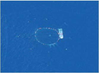
13 Marine Saving Fuel / Shipping Company To reduce fuel consumption for ecological & economical reasons 3 options: Optimize engines, propellers, hulls Improve organization Take benefit of Meteorology/ Operational Oceanography (current observations and forecast) 0.4% = Average thanks to "current routing" (Line Europe-China Q2 2015) Target: Save 1% thanks "current routing" (current forecast reliability) would lead to 60,000t fuel saving for the whole CMA-CGM fleet > 180,000t C02. By courtesy of CMA-CGM CMEMS Workshop ESS The Hague May 31st


14 Combatting Marine Litter plastic pollution Marine Drift computation based on CMEMS reanalysis over 10 years help the expedition optimize and finetune the itinerary in order to detect the potential pollution convergence areas in the North Atlantic. NGO Name of the event Place


15 Copernicus Copernicus, anticipating needs Micronekton distribution simulation, marine resource mgmt Assimilation of bio Argo data Size class chlorophyll assimilation 15


16 Copernicus and global challenges Copernicus The future of the seas and Oceans SDG 14 & the Tsukuba communiqué Copernicus marine services provide a high resolution daily observation and forecast of the global ocean Improving projections of global and regional scale long term variability Biogeochemical projections help in assessing the C02 biological pump of the ocean, or its acidification 25 years reanalysis support climate projections and decadal variability analysis Sustaining the productive capacity and resilience of ocean ecosystems under human activities pressure marine biodiversity conservation benefiting from biogeochemical forecasts entering in marine ecosystems modelling (ie. Pelagic fish stocks, turtles,..) the 7 th continent Minimise human impacts by sustainably harvesting marine resources Biogeochemical forecasts better predicting fish stock migration and resources sustainable planning Supporting the UN regular process for global reporting and assessment of the state of the marine environment Contribution of the ocean state report Written by 80 European scientific experts from more than 25 institutions. Independent peer review

17 The Copernicus security service Security Support to EU External Actions Border Surveillance Maritime Surveillance

18 The Copernicus Security service Security 3 Security Services Border Surveillance Support to EU External Actions Maritime Surveillance To provide enhanced observation capacities for the surveillance of human activities at sea, with a special focus on security, safety and environmental (e.g. pollution, fisheries) issues Operated by the European Maritime Safety Agency in Lisbon Available to EU Member States Authorized Users only NO Public access Since Dec 2015


19 Copernicus Maritime Surveillance Service Security Fisheries Control Maritime Safety and Security Law Enforcement Customs Marine Environment Other (defence, antipiracy) Function areas served by the Copernicus Maritime Surveillance Service


20 Many space sensors and in situ data Security Sentinel 1 C band Radar Sentinel 2 Imager Sentinel 3 Ocean mission Many partnerships With Contributing missions Very High Resolution Optical and radar Imagery Sentinel 6 Ocean mission LRIT VMS On board equipments

 UAV")

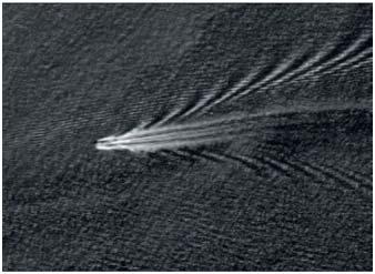
21 Security M a r i t i m e Surveillance Security All services are a Combination of Technology / Data Fusion Satellite data (radar, optical) Vessel reporting systems (AIS, VMS, LRIT) UAV surveillance for Novel sensor concepts Processed Data supplied within 30min after acquisition (Near real time)
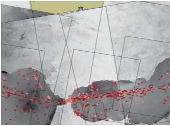
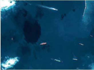
22 CMS Illegal fishing with SAR imagery Security Multi-purpose - Maritime Safety and Security & Law Enforcement Fishing activity pattern VDS targets Reporting positions, Sat AIS LEGEND Red not correlated Yellow correlated fishing vessel White correlated other vessel RADARSAT 2 Data and Products MacDONALD, DETTWILER AND ASSOCIATES LTD [2016] All Rights Reserved and RADARSAT is an official mark of the Canadian Space Agency EMSA Vessel detection EMSA, contains modified Radarsat-2 data, 2017


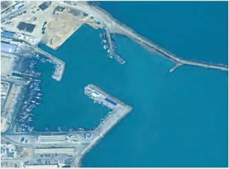
23 Anti piracy support Security Data Fusion Image Interpretation E.g port monitoring Optical satellite imagery Potential source for value added information (e.g. surveillance) Credits EMSA 23


24 ACTU Security JCOMM 5 will be held in Denpasar, Bali from October 25th to 29th, Technical group TECO Toward an Integrated Metocean, Forecasting and Services System October 23rd to the 24th, 2017 With the contribution to the scientific board of N. Florida Riama, Marine Met Center, Indonesia Pierre Bahurel, Mercator Ocean CEO and delegate for the Copernicus Marine Service

25 Thank you for your attention Copernicus EU Copernicus EU Copernicus EU
T h e C o p e r n i c u s m a r i n e s e r v i c e. DG-GROW, Copernicus. Copernicus EU
 T h e C o p e r n i c u s m a r i n e s e r v i c e DG-GROW, Copernicus Copernicus EU Copernicus EU Copernicus EU www.copernicus.eu 2 W h y is t h e m a r i n e s e c t o r so i m p o r t a n t? Blue Economy,
CopernicusEU. the EU's Earth Observation Programme. Sara Zennaro Atre Delegation of the European Union to Japan
 Copernicus the EU's Earth Observation Programme Sara Zennaro Atre Delegation of the European Union to Japan Status Overview, Sept 2016 & Ocean Policies Seminar 4 October 2016 ollow us on: Copernicus EU
sentinel-3 A BIGGER PICTURE FOR COPERNICUS
 sentinel-3 A BIGGER PICTURE FOR COPERNICUS SATELLITES TO SERVE By providing a set of key information services for a wide range of practical applications, Europe s Copernicus programme has been put in place
A state of the art and user driven Copernicus service Physics and Biogeochemistry
 C M E M S P r e s e n t a n d F u t u r e R e q u i r e m e n t s f o r I n - S i t u a n d S a t e l l i t e O b s e r v a t i o n s Antonio REPPUCCI; Pierre Yves LE TRAON Mercator Ocean International
Copernicus Marine Environment Monitoring Service
 Copernicus Marine Environment Monitoring Service Mercator Ocean March 2017 Implemented by Entrusted to Mercator Ocean by the European Commission Cliquez et modifiez le titre French non-profit company Owned
HY-2A Satellite User s Guide
 National Satellite Ocean Application Service 2013-5-16 Document Change Record Revision Date Changed Pages/Paragraphs Edit Description i Contents 1 Introduction to HY-2 Satellite... 1 2 HY-2 satellite data
Julia Figa-Saldaña & Klaus Scipal
 Julia Figa-Saldaña & Klaus Scipal julia.figa@eumetsat.int klaus.scipal@esa.int Meeting, Outline MetOp/EPS status MetOp/EPS Second Generation status 2016 scatterometer conference Other European ocean programme
MERSEA Marine Environment and Security for the European Area
 MERSEA Marine Environment and Security for the European Area Development of a European system for operational monitoring and forecasting of the ocean physics, biogeochemistry, and ecosystems, on global
C o p e r n i c u s M a r i n e S e r v i c e i n s u p p o r t t o s u s t a i n a b l e B l u e G r o w t h
 Implemented by C o p e r n i c u s M a r i n e S e r v i c e i n s u p p o r t t o s u s t a i n a b l e B l u e G r o w t h European Commission, DG MARE 19 Januray 2018 C O P E R N I C U S I N B R I E
EO4SEE - THE PATHFINDER OF OPERATIONAL SATELLITE MONITORING FOR THE REGION OF THE BLACK SEA AND CENTRAL EUROPE
 EO4SEE: Pathfinder assessment for regional high volume data access, processing and information service delivery platforms - South East Region EO4SEE - THE PATHFINDER OF OPERATIONAL SATELLITE MONITORING
CAMS. Vincent-Henri Peuch (ECMWF) Atmosphere Monitoring. Copernicus EU.
 Atmosphere Monitoring. Copernicus EU.") CAMS COPERNICUS ATMOSPHERE M O NITO RING SERVICE Vincent-Henri Peuch (ECMWF) Copernicus EU Copernicus EU Copernicus EU www.copernicus.eu W H A T I S C O P E R N I C U S? Copernicus Copernicus is a flagship
CAMS COPERNICUS ATMOSPHERE M O NITO RING SERVICE Vincent-Henri Peuch (ECMWF) Copernicus EU Copernicus EU Copernicus EU www.copernicus.eu W H A T I S C O P E R N I C U S? Copernicus Copernicus is a flagship
EUMETSAT STATUS AND PLANS
 1 EUM/TSS/VWG/15/826793 07/10/2015 EUMETSAT STATUS AND PLANS François Montagner, Marine Applications Manager, EUMETSAT WMO Polar Space Task Group 5 5-7 October 2015, DLR, Oberpfaffenhofen PSTG Strategic
Copernicus Today and Tomorrow GEO Week Group on Earth Observation Geneva, 16 January 2014 The Copernicus Space Infrastructure
 Copernicus Today and Tomorrow GEO Week Group on Earth Observation Geneva, 16 January 2014 The Copernicus Space Infrastructure Thomas Beer, Policy Coordinator, Copernicus Space Office, ESA-ESRIN, Frascati
C o p e r n i c u s a n d W I G O S
 C o p e r n i c u s a n d W I G O S Jean-Noël Thépaut & Mark Dowell 24 October 2017 GEO XIV, Washington DC, 23-28 October 2017 T h e C o p e r n i c u s P r o g r a m m e Copernicus is the European Union
Operational systems for SST products. Prof. Chris Merchant University of Reading UK
 Operational systems for SST products Prof. Chris Merchant University of Reading UK Classic Images from ATSR The Gulf Stream ATSR-2 Image, ƛ = 3.7µm Review the steps to get SST using a physical retrieval
Ocean Observation from Haiyang Satellites:
 SPACE SCIENCE ACTIVITIES IN CHINA Ocean Observation from Haiyang Satellites: 2012 2014 AUTHORS JIANG Xingwei LIN Mingsen National Satellite Ocean Application Service, Beijing 100081 ABSTRACT During 2012
Toward Environmental Predictions MFSTEP. Executive summary
 Research Project co-funded by the European Commission Research Directorate-General 5 th Framework Programme Energy, Environment and Sustainable Development Contract No. EVK3-CT-2002-00075 Project home
Sentinel-1 Mission Status
 Sentinel-1 Mission Status Pierre Potin, Sentinel-1 Mission Manager, ESA Luca Martino, Technical Support Engineer, ESA... and the Sentinel-1 operations team PSTG SAR Coordination Working Group 14 December
NOAA/OAR Observing Systems
 NOAA/OAR Observing Systems Dr. Christopher L. Sabine Director NOAA s Pacific Marine Environmental Laboratory Workshop on Hydroclimate Monitoring Systems and Measurement Needs June, 2014 Global Ocean Observing
Marine Situational Awareness and Environmental Monitoring using Satellites
 1 The Ny-ålesund Symposium 2013 The Changing Arctic Opportunity or Threat Marine Situational Awareness and Environmental Monitoring using Satellites Rolf Skatteboe President, Kongsberg Satellite Services
GREEN Grog : Global Reanalysis of Ocean. biogeochemistry :
 Colloque LEFE Clermont-Ferrand, 28-30 mars 2018 GREEN Grog : Global Reanalysis of Ocean biogeochemistry : Isabelle Dadou (LEGOS) Marion Gehlen (IPSL/LSCE) marion.gehlen@lsce.ipsl.fr and the GREEN Grog
Securing EUMETSAT s Mission from an Evolving Space Environment
 Securing EUMETSAT s Mission from an Evolving Space Environment ESPI 12 th Autumn Conference Andrew Monham 1 EUMETSAT: Intergovernmental Organisation of 30 Member States Presentation Contents AUSTRIA BELGIU
Ocean Monitoring and Forecasting core services,
 MY OCEAN Marine Core Service Ocean Monitoring and Forecasting core services, the MyOcean example Pierre BAHUREL MyOcean coordinator Mercator Ocean, France Session 5B "The way forward: delivering societal
Copernicus Space Component Status & Evolution
 Copernicus Space Component Status & Evolution ESCAP, Bangkok 09 October 2017 Simon Jutz Head of the ESA Copernicus Space Office Directorate of Earth Observation Programmes 28 satellites in development
A BRIEF INTRODUCTION TO COPERNICUS AND CAMS
 A BRIEF INTRODUCTION TO COPERNICUS AND CAMS Juan Garcés de Marcilla Director of Copernicus Services European Centre for Medium-Range Weather Forecasts Copernicus EU Copernicus EU Copernicus EU www.copernicus.eu
sentinel-2 COLOUR VISION FOR COPERNICUS
 sentinel-2 COLOUR VISION FOR COPERNICUS SATELLITES TO SERVE By providing a set of key information services for a wide range of practical applications, Europe s Copernicus programme is providing a step
COMBINING EUMETSAT AND SENTINEL MISSIONS TO CREATE NEW OPPORTUNITIES MONITORING WEATHER AND CLIMATE FROM SPACE
 COPERNICUS @EUMETSAT COMBINING EUMETSAT AND SENTINEL MISSIONS TO CREATE NEW OPPORTUNITIES MONITORING WEATHER AND CLIMATE FROM SPACE COPERNICUS A EUROPEAN RESPONSE TO THE CHALLENGE OF GLOBAL MONITORING
UN COPUOS 52 nd session of the Scientific and Technical Subcommittee. COPERNICUS - an European Achievement. S. Jutz Head, ESA Copernicus Space Office
 UN COPUOS 52 nd session of the Scientific and Technical Subcommittee COPERNICUS - an European Achievement S. Jutz Head, ESA Copernicus Space Office 11 Feb 2015, Vienna 1 2 What is Copernicus? European
Observing the Ocean:
 Observing the Ocean: A changing Paradigm A vision for Operational Oceanography James Baker* - Jean-François Minster ** * Chair Goos Committee,, Président CEO Academy of Natural Sciences Philadelphie **
E x a m p l e s o f t o o l s f o r s e a s i t u a t i o n a l a w a r e n e s s u s i n g C M E M S d a t a. Copernicus EU
 E x a m p l e s o f t o o l s f o r s e a s i t u a t i o n a l a w a r e n e s s u s i n g C M E M S d a t a Copernicus EU Copernicus EU Copernicus EU www.copernicus.eu S e a S i t u a t i o n a l A w
Polar Space Task Group Space Agency Report
 Polar Agency Report EUMETSAT WMO HQ, Geneva 16-18 October, 2018 EUMETSAT News EPS OSI SAF products Sentinel-3 PSTG8 Meeting, WMO, 16-18 Oct., 2018 EUMETSAT Polar System: Metop- C Launch Preparation Metop-C
EONav Satellite data in support of maritime route optimization
 EONav Satellite data in support of maritime route optimization Leif Eriksson Department of Space, Earth and Environment Chalmers University of Technology Outline Why is maritime navigation support needed?
Satelliten- gestuetzte Erdbeobachtung
 Satelliten- gestuetzte Erdbeobachtung SPIK 2018, Bern 21. Maerz 2018 Dr. Thomas Beer, ESA- ESRIN Politik Koordinator im Copernicus Weltraum- Buero Issue/Revision: 0.0 Reference: Status: ESA UNCLASSIFIED
A.2 Copernicus, Sentinels und Meer. Daten der Sentinel Satelliten - Datenprodukte und Anwendungsbeispiele
 Nationales Forum fuer Fernerkundung und Copernicus, 3. 5. Nov 2015, Berlin A.2 Copernicus, Sentinels und Meer Daten der Sentinel Satelliten - Datenprodukte und Anwendungsbeispiele Simon Jutz, Head, ESA
Earth Observation and GEOSS in Horizon Copernicus for Raw Material Workshop 5 th September 2016
 Earth Observation and GEOSS in Horizon 2020 Copernicus for Raw Material Workshop 5 th September 2016 Gilles OLLIER Head of Sector -Earth observation Directorate Environment Unit I.4 Climate Actions and
Earth Observation Satellites Dawn of Application Specific Satellite Data. Date: 26 July 2017
 Earth Observation Satellites Dawn of Application Specific Satellite Data Date: 26 July 2017 Introducing a World of New Possibilities Satellite imagery is a critical fountain of information on al levels
Exploiting maritime Big Data, the Blue Hub
 Exploiting maritime Big Data, the Blue Hub Marlene Alvarez Alvarez, Michele Vespe, Harm Greidanus Marlene.alvarez@jrc.ec.europa.eu Joint Research Centre the European Commission's in-house science service
Towards eenvironment Prague, March GMES Space Component. Josef Aschbacher Head, ESA GMES Space Office
 Towards eenvironment Prague, 25-27 March 2009 GMES Space Component Josef Aschbacher Head, ESA GMES Space Office Prague from Space Segment 2 05 Nov 2003 CNES 2003 GISAT 2007 ESA GSELAND GMES is an EU led
LESSON THREE Time, Temperature, Chlorophyll a Does sea surface temperature affect chlorophyll a concentrations?
 STUDENT PAGES LESSON THREE A partnership between California Current Ecosystem Long Term Ecological Research (CCE LTER) and Ocean Institute (OI) Beth Simmons, Education and Outreach Coordinator, CCE LTER,
Opportunities for advanced Remote Sensing; an outsider s perspective
 Opportunities for advanced Remote Sensing; an outsider s perspective Ramon Hanssen Delft University of Technology 1 Starting questions Can we do more with the data we are already acquire? What s in stock
Ice surveys, meteorological and oceanographic data What is available and up-to-date?
 Ice surveys, meteorological and oceanographic data What is available and up-to-date? Leader of the Norwegian Ice Service +47 77 62 13 15 - nick.hughes@met.no Norwegian Meteorological Institute met.no 1
The known requirements for Arctic climate services
 The known requirements for Arctic climate services based on findings described in STT White paper 8/2015 Johanna Ekman / EC PHORS STT Regional drivers The Arctic region is home to almost four million people
FOURTH INTERNATIONAL PORT METEOROLOGICAL OFFICERS WORKSHOP AND SUPPORT TO GLOBAL OCEAN OBSERVATIONS USING SHIP LOGISTICS
 FOURTH INTERNATIONAL PORT METEOROLOGICAL OFFICERS WORKSHOP AND SUPPORT TO GLOBAL OCEAN OBSERVATIONS USING SHIP LOGISTICS PMO-IV 8-10 DEC 2010, ORLANDO, FLORIDA, USA 1 This presentation is generally for
Carbon pathways in the South Atlantic
 Carbon pathways in the South Atlantic Olga T. Sato, Ph.D. Paulo Polito, Ph.D. olga.sato@usp.br - polito@usp.br Oceanographic Institute University of São Paulo Olga Sato and Paulo Polito (IOUSP) Carbon
Monitoring the coastal ocean: from local to regional
 Monitoring the coastal ocean: from local to regional Luísa Bastos University of Porto / CIIMAR RAIA partners Ocean monitoring To answer key societal and scientific challenges navigation safety, fisheries,
Copernicus Opportunities and Challenges in Europe s eyes on Earth
 Copernicus Opportunities and Challenges in Europe s eyes on Earth Gunter Schreier Deputy Director DLR German Remote Sensing Data Center - Earth Observation Center Rotterdam 25. Mai 2016 Sentinel - Missions
The GMES/MyOcean Marine Service and its applications
 The GMES/MyOcean Marine Service and its applications P.Y. Le Traon (Ifremer) P. Bahurel (Mercator Ocean) First BreTel Workshop May 31st, 2012 - St Malo Outline The GMES Marine Service and MyOcean What
Cristina Ananasso Copernicus Unit DG GROW. H2020 Space: Calls on Earth Observation and Copernicus Ilan Ramon Conference 28/01/2018 Tel Aviv
 Cristina Ananasso Copernicus Unit DG GROW H2020 Space: Calls on Earth Observation and Copernicus Ilan Ramon Conference 28/01/2018 Tel Aviv OUTLINE Call Space 2018-2020 - Earth Observation and Copernicus
Infrastructure monitoring using SAR interferometry
 Infrastructure monitoring using SAR interferometry Hossein Nahavandchi Roghayeh Shamshiri Norwegian University of Science and Technology (NTNU), Department of Civil and Environmental Engineering Geodesy
Sentinel-1 Mission Status
 Sentinel-1 Mission Status Pierre Potin, Sentinel-1 Mission Manager 5TH GEOGLAM RAPP Workshop 16-17 May 2017, ESRIN Sentinel-1: Copernicus radar imaging mission for ocean, land, emergency Part of the Copernicus
THE COPERNICUS PROGRAMME
 THE COPERNICUS PROGRAMME Jolyon Martin, Sentinel Data Access Manager & Sentinel-5P Operations Manager, ESA Pierre Potin, Sentinel-1 Mission Manager, ESA Earth Observation Showcase Emerging Applications
16/11/2016. Earth Observation Data for Fisheries & Aquaculture Perspectives from European Initiatives
 Earth Observation Data for Fisheries & Aquaculture Perspectives from European Initiatives Rory Scarrott (UCC MaREI) UCC, GG6502, November 15 th, 2016 Lecture 1: Background and parameters This project has
IPSENTINEL. The Collaborative Infrastructure for Sentinel Data in Portugal. IPSentinel
 IPSENTINEL The Collaborative Infrastructure for Sentinel Data in Portugal 1 MISSION The Directorate-General for the Territory Development (DGT) and the Portuguese Institute for the Sea and the Atmosphere
Future perspectives for EO in Development
 Future perspectives for EO in Development Meeting at ESA/ESRIN in Frascati 11 th of September 2018 #WorldInCommon AGENCE FRANÇAISE DE DÉVELOPPEMENT FRENCH DEVELOPMENT AGENCY 01. What is AFD? France s international
Arctic Observing Systems Challenges, New opportunities and Integration
 Arctic Observing Systems Challenges, New opportunities and Integration Japan Norway Arctic Science Week 03 June 2016 By Stein Sandven, NERSC Building an integrated Arctic Observing System Need to collect,
NEW CGMS BASELINE FOR THE SPACE-BASED GOS. (Submitted by the WMO Secretariat) Summary and Purpose of Document
 Summary and Purpose of Document") WORLD METEOROLOGICAL ORGANIZATION COMMISSION FOR BASIC SYSTEMS OPEN PROGRAMME AREA GROUP ON INTEGRATED OBSERVING SYSTEMS EXPERT TEAM ON SATELLITE SYSTEMS ET-SAT-7/Inf. 2 (12.III.2012) ITEM: 8.1 SEVENTH
WORLD METEOROLOGICAL ORGANIZATION COMMISSION FOR BASIC SYSTEMS OPEN PROGRAMME AREA GROUP ON INTEGRATED OBSERVING SYSTEMS EXPERT TEAM ON SATELLITE SYSTEMS ET-SAT-7/Inf. 2 (12.III.2012) ITEM: 8.1 SEVENTH
Liana Talaue McManus. Division of Marine Affairs and Policy Rosenstiel School of Marine & Atmospheric Science University of Miami
 Liana Talaue McManus Division of Marine Affairs and Policy Rosenstiel School of Marine & Atmospheric Science University of Miami Outline 1. Coasts as vulnerable & resilient social ecological systems 2.
EUMETSAT s Copernicus Marine Data Stream (CMDS)
") EUMETSAT s Copernicus Marine Data Stream (CMDS) Hayley Evers-King (PML, Copernicus Ocean Training Service), Mark Higgins Copernicus Sentinel 3 marine data Sentinel 3 SRAL (Altimetry) SLSTR (SST) OLCI (Ocean
EUMETSAT s Copernicus Marine Data Stream (CMDS) Hayley Evers-King (PML, Copernicus Ocean Training Service), Mark Higgins Copernicus Sentinel 3 marine data Sentinel 3 SRAL (Altimetry) SLSTR (SST) OLCI (Ocean
Council conclusions on Arctic issues. 2985th FOREIGN AFFAIRS Council meeting Brussels, 8 December 2009
 COU CIL OF THE EUROPEA U IO EN Council conclusions on Arctic issues 2985th FOREIGN AFFAIRS Council meeting Brussels, 8 December 2009 The Council adopted the following conclusions: The Council recalls its
Explain the impact of location, climate, natural resources, and population distribution on Europe. a. Compare how the location, climate, and natural
 SS6G10 Explain the impact of location, climate, natural resources, and population distribution on Europe. a. Compare how the location, climate, and natural resources of Germany, the United Kingdom and
GODAE Status. OSEs/OSSEs meeting objectives. P.Y. le Traon, A. Fischer, E. Harrison, K. Wilmer Becker
 GODAE Status OSEs/OSSEs meeting objectives P.Y. le Traon, A. Fischer, E. Harrison, K. Wilmer Becker Content 3. GODAE Status Achievements and successes Priorities GODAE in 2007/2008 5. Objectives of the
An Update on EUMETSAT Programmes and Plans. Dieter Klaes on behalf of EUMETSAT teams
 An Update on EUMETSAT Programmes and Plans Dieter Klaes on behalf of EUMETSAT teams 1 21 st International TOVS Study Conference (ITSC), Darmstadt, Germany, 29 November 2017 5 December 2017 Current EUMETSAT
EUMETSAT Climate Activities
 EUMETSAT Climate Activities Jörg Schulz EUMETSAT s Role in Climate Monitoring EUMETSAT has a prominent role in the world for providing services relevant to climate: EUMETSAT maintains some of the longest
Ocean meets Regions conference Committee of the Regions, Brussels 21 November 2017 Cecilia Donati. Marine Monitoring.
 Implemented by C o p e r n i c u s M a r i n e S e r v i c e : a E u r o p e a n t o o l i n s u p p o r t o f P u b l i c A d m i n i s t r a t i o n f o r a s u s t a i n a b l e B l u e G r o w t h
Space research. Horizon Work Programme. "Countdown to Horizon 2020 Space" Earth Observation topics. Brussels, 12 December 2013
 Space research Horizon 2020 - Work Programme "Countdown to Horizon 2020 Space" Earth Observation topics Brussels, 12 December 2013 richard.gilmore@ec.europa.eu Table of contents FP/Copernicus - general
NOAA Nautical Charts and Coastal and Marine Spatial Planning. Meredith Westington Chief Geographer NOAA/NOS/Office of Coast Survey
 NOAA Nautical Charts and Coastal and Marine Spatial Planning Meredith Westington Chief Geographer NOAA/NOS/Office of Coast Survey Ocean Policy Task Force What is CMSP? A comprehensive, adaptive, integrated,
MONITORING THE ATMOSPHERE, OCEAN AND CLIMATE FROM SPACE
 MONITORING THE ATMOSPHERE, OCEAN AND CLIMATE FROM SPACE TRANSFORMING OUR WORLD MONITORING WEATHER AND CLIMATE FROM SPACE MONITORING THE ATMOSPHERE, OCEAN AND CLIMATE FROM SPACE FOR TRANSFORMING OUR WORLD
Satellite Oceanography: an integrated perspective. ESA UNCLASSIFIED - For Official Use
 Satellite Oceanography: an integrated perspective ESA UNCLASSIFIED - For Official Use ESA UNCLASSIFIED - For Official Use How to contribute/accelerate new skills/discoveries to help reveal and model unknow
The use and impacts of sea surface temperature from passive microwave measurements
 The use and impacts of sea surface temperature from passive microwave measurements Anne O Carroll 6/12/2017 ECMWF workshop on using low frequency passive microwave measurements in research and operational
The Mediterranean Operational Oceanography Network (MOON): Products and Services
: Products and Services") The Mediterranean Operational Oceanography Network (MOON): Products and Services The MOON consortia And Nadia Pinardi Co-chair of MOON Istituto Nazionale di Geofisica e Vulcanologia Department of Environmental
The Mediterranean Operational Oceanography Network (MOON): Products and Services The MOON consortia And Nadia Pinardi Co-chair of MOON Istituto Nazionale di Geofisica e Vulcanologia Department of Environmental
Weather & Ocean Currents
 Weather & Ocean Currents Earth is heated unevenly Causes: Earth is round Earth is tilted on an axis Earth s orbit is eliptical Effects: Convection = vertical circular currents caused by temperature differences
ESA s Earth Observation Programmes
 ESA s Earth Observation Programmes 2015 DRAGON Symposium Interlaken, 23 June 2015 Maurice Borgeaud Head of the Department Science, Applications, and Future Technologies ESA Earth Observation Programmes
Copernicus Marine Environment Monitoring Service (CMEMS) Service Evolution Strategy: R&D priorities
 Service Evolution Strategy: R&D priorities") Copernicus Marine Environment Monitoring Service (CMEMS) Service Evolution Strategy: R&D priorities Version 3 June 2017 Document prepared by the CMEMS Scientific and Technical Advisory Committee (STAC)
Copernicus Marine Environment Monitoring Service (CMEMS) Service Evolution Strategy: R&D priorities Version 3 June 2017 Document prepared by the CMEMS Scientific and Technical Advisory Committee (STAC)
Near Real Time Applications for Maritime Situational Awareness
 Near Real Time Applications for Maritime Situational Awareness Egbert Schwarz Maritime Security Lab Neustrelitz (DFD) ATLAS MEETS SCIENCE Bremen, 12.-13. October 2016 Presentation Outline Background Earth
Status report on current and future satellite systems by EUMETSAT Presented to CGMS-44, Plenary session, agenda item D.1
 Status report on current and future satellite systems by EUMETSAT Presented to CGMS-44, Plenary session, agenda item D.1 CGMS-44-EUMETSAT-WP-19.ppt, version 1 (# 859110), 8 June 2016 MISSION PLANNING YEAR...
ROADMAP FOR A GMES OPERATIONAL OCEANOGRAPHY MISSION
 ROADMAP FOR A GMES OPERATIONAL OCEANOGRAPHY MISSION Mark Drinkwater (1), Helge Rebhan (1), Pierre-Yves Le Traon (2), Laurent Phalippou (3), David Cotton (4), Johnny Johannessen (5), Giulio Ruffini (6),
Real GDP Growth to Clock 6.75 Percent this Fiscal. Economic Survey Predicts Percent Growth in
 ETEN Enlightens-Daily current capsules (Prelims Prominence) 30 th Jan 2018 Economic Survey 2017-18 Real GDP Growth to Clock 6.75 Percent this Fiscal Economic Survey Predicts 7-7.5 Percent Growth in 2018-19
Status of EUMETSAT Operational Services & EUMETCast Africa Dissemination Baseline Updates
 Status of EUMETSAT Operational Services & EUMETCast Africa Dissemination Baseline Updates Sally Wannop User Relations Manager 1 8th WMO RAIDEG meeting 1-2 November 2017 # 951881 Overview EUMETCast Overview
Weather and ice information as a tool for arctic marine and offshore services
 Weather and ice information as a tool for arctic marine and offshore services World Meteorological Organization Executive Council Panel of Experts on Polar Observations, Research and Services President
Emergency Management Service (EMS) mapping
 mapping") GMES Emergency Management Service (EMS) mapping Frédéric BASTIDE GMES unit, European Commission UN-SPIDER Expert Meeting: "Crowdsource Mapping for Disaster Risk Management and Emergency Response" 3-5 December,
GMES Emergency Management Service (EMS) mapping Frédéric BASTIDE GMES unit, European Commission UN-SPIDER Expert Meeting: "Crowdsource Mapping for Disaster Risk Management and Emergency Response" 3-5 December,
Environmental Data In Support of Search & Rescue Operations in the Central Mediterranean Sea
 Environmental Data In Support of Search & Rescue Operations in the Central Mediterranean Sea Dr. Eric Comerma (RPS ASA) eric.comerma@rpsgroup.com Cathleen Turner (RPS ASA) Prof. Aldo Drago (Univ. of Malta)
Operational ice charting in mid-latitudes using Near-Real-Time SAR imagery
 Operational ice charting in mid-latitudes using Near-Real-Time SAR imagery Sergey Vernyayev Ice Engineer ICEMAN.KZ Carles Debart Project Manager Energy, Environment and Security Yevgeniy Kadranov Ice charting
Space for the Arctic
 Space for the Arctic Bo Andersen Norwegian Polar Committee & Norwegian Space Centre 1 My Mantra for Space Few, if any of the global challenges can be resolved by space alone But Few, if any can be resolved
IMOS Blue Water and Climate. 1. Science highlights 2. Opportunities 3. Impediments
 IMOS Blue Water and Climate 1. Science highlights 2. Opportunities 3. Impediments CTDs on seals Tagged animals: Research outputs Recent publications: 1. Bestley, S., I. D. Jonsen, et al. (2013). Integrative
Overview and Status of ESA Earth Observation Programmes
 Overview and Status of ESA Earth Observation Programmes Maurice Borgeaud, ESA Head of the Science, Applications and Future Technologies Department Directorate of Earth Observation Programmes ADM-Aeolus
Operational Monsoon Monitoring at NCEP
 Operational Monsoon Monitoring at NCEP Wassila M. Thiaw Climate Prediction Center National Centers for Environmental Predictions Operational Monsoon Monitoring at NCEP Wassila M. Thiaw Climate Prediction
Ocean currents from altimetry
 Ocean currents from altimetry Pierre-Yves LE TRAON - CLS - Space Oceanography Division Gamble Workshop - Stavanger,, May 2003 Introduction Today: information mainly comes from in situ measurements ocean
- Global Reanalysis of Ocean biogeochemistry : GREEN Grog -
 Journées GMMC Toulon, 7-9 juin 2016 - Global Reanalysis of Ocean biogeochemistry : - Marion Gehlen (IPSL/LSCE) marion.gehlen@lsce.ipsl.fr and the consortium A new PPR associating : Mercator-Océan CLS,
53 contributors for 35 individual reports in 2009 show 5% of figures today
 A Group Approach to Understanding Ecosystem Dynamics in the Northeast Pacific Ocean William Crawford and James Irvine, Fisheries and Oceans Canada (DFO) * * * 53 contributors for 35 individual reports
Copernicus Marine Environment Monitoring Service (CMEMS) Service Evolution Strategy: R&D priorities
 Service Evolution Strategy: R&D priorities") Copernicus Marine Environment Monitoring Service (CMEMS) Service Evolution Strategy: R&D priorities Version 2 20 September 2016 Document prepared by the CMEMS Scientific and Technical Advisory Committee
Copernicus Marine Environment Monitoring Service (CMEMS) Service Evolution Strategy: R&D priorities Version 2 20 September 2016 Document prepared by the CMEMS Scientific and Technical Advisory Committee
Why do we need a global framework for MPAs in ABNJ? Kristina M. Gjerde IUCN High Seas Policy Advisor
 Why do we need a global framework for MPAs in ABNJ? Kristina M. Gjerde IUCN High Seas Policy Advisor kgjerde@eip.com.pl 40% ocean heavily affected by humans (c) Halpern et al. 2008. Scientists found that
South Asian Climate Outlook Forum (SASCOF-6)
") Sixth Session of South Asian Climate Outlook Forum (SASCOF-6) Dhaka, Bangladesh, 19-22 April 2015 Consensus Statement Summary Below normal rainfall is most likely during the 2015 southwest monsoon season
Sixth Session of South Asian Climate Outlook Forum (SASCOF-6) Dhaka, Bangladesh, 19-22 April 2015 Consensus Statement Summary Below normal rainfall is most likely during the 2015 southwest monsoon season
Observation system for early warning of HAB events
 Observation system for early warning of HAB events Vera L. Trainer, NOAA Fisheries Northwest Fisheries Science Center Marine Biotoxins Program Seattle, Washington, USA Juan de Fuca eddy Regional HAB OOS
EUSAIR on sea topics from Slovenian perspective
 MINISTRY OF FOREIGN AFFAIRS REPUBLIC OF SLOVENIA EUSAIR on sea topics from Slovenian perspective Mag. Andreja Jerina National Coordinator 4 EU MRS: 270 millions of population 19 MS 12 non MS Sea basin
Current experiences in the use of satellite information in development aid activities
 Current experiences in the use of satellite information in development aid activities Meeting at ESA/ESRIN in Frascati 16 th of September 2017 #WorldInCommon AGENCE FRANÇAISE DE DÉVELOPPEMENT FRENCH DEVELOPMENT
Seabed knowledge In support of UN SDGs
 Seabed knowledge In support of UN SDGs Evert Flier Fiskerifaglig forum 2. november 2017 Hydrography & small scale fishing Hydrography in Transition Serving the Maritime Community Hydrography in Transition
The Earth Explorer Missions - Current Status
 EOQ N 66 July 2000 meteorology earthnet remote sensing solid earth future programmes Earth Observation Quarterly The Earth Explorer Missions - Current Status G. Mégie (1) and C.J. Readings (2) (1) Institut
The North Atlantic Oscillation: Climatic Significance and Environmental Impact
 1 The North Atlantic Oscillation: Climatic Significance and Environmental Impact James W. Hurrell National Center for Atmospheric Research Climate and Global Dynamics Division, Climate Analysis Section
JCOMM Overview. Val Swail Environment and Climate Change Canada JCOMM representative to IOGP Metocean Committee
 JCOMM Overview Val Swail Environment and Climate Change Canada JCOMM representative to IOGP Metocean Committee IOGP/JCOMM/WCRP Workshop Our Future Climate Understanding the spread of physical risk for
Current status of the remote sensing ocean observing system
 Current status of the remote sensing ocean observing system Pierre-Yves Le Traon Ifremer & Mercator ocean with contributions from G. Dibarboure, Y. Faugere, M.H. Rio, B. Chapron, J. Johannessen, L. Santolieri,