Satelliten- gestuetzte Erdbeobachtung
|
|
|
- Alexia Simpson
- 6 years ago
- Views:
Transcription
1 Satelliten- gestuetzte Erdbeobachtung SPIK 2018, Bern 21. Maerz 2018 Dr. Thomas Beer, ESA- ESRIN Politik Koordinator im Copernicus Weltraum- Buero Issue/Revision: 0.0 Reference: Status: ESA UNCLASSIFIED - For Official Use
2 Slide 2

3 Space 4.0: a new era of space Slide 3


4 Slide 4

5 Copernicus European Leadership in EO Slide 5

")


6 Copernicus Contributing Missions SPOT (VGT) COSMO-Skymed PROBA-V TerraSAR X Tandem-X Radarsat DMC Pléiades Deimos-2 RapidEye Copernicus Contributing Missions Atmospheric missions Jason Cryosat SPOT (HRS) MetOp Meteosat 2 nd Generation Slide 6
7 Copernicus Data Policy Sentinel Data Policy = FULL, FREE, OPEN access ESA Sentinel Data Policy (Sep 2013) and EU Delegated Act on Copernicus Data and Information Policy (Dec 2013) Main principles of Sentinel data policy: Open access to Sentinel data by anybody and for any use Free of charge data licenses Restrictions possible due to technical limitations or for security reasons Slide 7

8 Registered Sentinel Users 125' '000 75' PB Volume of User Downloads 50'000 25'000 Copernicus User Uptake 0 Jan 15Jul 15Jan 16Jul 16Jan 17Jul 17Jan 1 sentinels.copernicus.eu Slide 8

9 Big Data Revolution ESA EO Data Archive Petabyte Sentinel missions operated by ESA Earth Explorer missions Heritage missions Third Party & Contributing Missions Slide 9


10 Generating Growth From 2008 to 2020, the total investments in the Copernicus Programme are forecasted to reach 7.5 B. Likewise, this investment will generate a direct monetary benefit of 13.5 B. Copernicus Market Report, PWC, 2016 The Copernicus Programme is expected to result in the creation of about 48,000 jobs over the period EC staff working document, 2015, EC SWD(2013) 190 final Slide 10
11 The Copernicus Services Copernicus Land Monitoring Service (CLMS) Managing entity: EEA and JRC Copernicus Climate Change Service (C3S) Managing entity: ECMWF Copernicus Atmosphere Monitoring Service (CAMS) Managing entity: ECMWF Copernicus Emergency Management Service (CEMS) Managing entity:jrc Copernicus Marine Monitoring Service (CMEMS) Managing entity: Mercator Ocean Copernicus Security Service Managing entity: EMSA, SATCEN and FRONTEX Slide 11

12 EO Supporting Global Policies Sustainable Development UN SDGs Climate Action Paris Agreement Disaster Risk Reduction Sendai Framework Measuring Status & Progress Monitoring & Understanding Supporting Resilient Infrastructure Slide 12
13 Land Ice Melting Antarctic Ice Sheet Monitoring Based on Cryosat data over three years ( ) CPOM/Leeds/ESA Slide 13

14 Rising Sea Levels Mean Sea Level Rise (mm) Sea level rise is accelerating. Sea levels could rise another 1.3 meters in the next 80 years. < Compiled Ocean Altimetry Satellite Data Proceedings of the National Academy of Sciences Sentinel-6 fromfebruary Slide 14


15 Monitoring Rice Yields Duong Delta Northern Vietnam Based on Sentinel-1 Data TU Wien, GEO Slide 15

16 Emergency Management and Security Services Slide 16

 Interferogram obtained combining")

 and lateral")
17 Sentinel-1A: Example of Land Monitoring Devastating earthquake in central Italy on 24 th August 2016 (Magnitude: 6.2) Interferogram obtained combining Sentinel-1A images before and after the earthquake and showing ground deformation Credits: Panorama & AP Images Vertical ground subsidence (~20 cm) and lateral movement (~16 cm) around Accumoli Slide 17

 Saint-Barthelemy after Irma")
18 Copernicus Space Component Data Access: spacedata.copernicus.eu before Irma hurricane (4 Sept. 2017) Saint-Barthelemy after Irma hurricane (12 Sept. 2017) Slide 18


19 Flood in Vietnam, 22 Nov 2017 Contains modified Copernicus Sentinel data (2017), map produced by UNITAR / UNOSAT Slide 19

20 Haiti Earthquake Support - Post-event Analysis Port-Au-Prince Int. Airport Slide 20
 -Transport hubs; airport and port (Insets 3, 6, 7) Additionally,this map shows possible roadblocks (Insets 1 and 2) detected on the")
21 This map illustrates the main strategic information for possible evacuat ion plans. It consists ot -PHLS (Possible Helicopter Landing Sites);open areas for concentration of people or material. -Embassies, governmental buildings -Medical buildings (Insets 4,5) -Transport hubs; airport and port (Insets 3, 6, 7) Additionally,this map shows possible roadblocks (Insets 1 and 2) detected on the image and areas under development mostly in port area. Slide 21
 Populated Areas Hydrography Administrative Boundaries Detailed Transportation Network (All roads classified according to hierarchy, checkpoints, harbours, airfields, train and")
22 PREPAREDNESS CRISIS REFERENCE MAP MODE INFORMATION LAYERS Reference Maps are high quality cartographic products including a wide range of observable features Transportation Network (Main Roads, Harbours, Airfields) Populated Areas Hydrography Administrative Boundaries Detailed Transportation Network (All roads classified according to hierarchy, checkpoints, harbours, airfields, train and bus stations) Points of Interest (industrial, power production, electricity, military, dams, generic enclosed facilities) Topography Place Names (multilingual support) Land Use/Land Cover IMAGERY USED Optical Imagery (from<1m to 10m) APPLICABLE SCALE 5K Very Detail (Facilities) 25K Small Urban Areas 50K Large Urban Areas 100K Small Regions 500K Large Regions Slide 22
")
23 Facility Security Analysis (overview) Slide 23

24 Facility (Hotel) Security analysis - Accesses Slide 24
25 Nuclear Security Summit 2014 The Hague (NL) Scenario: The 2014 Nuclear Security Summit was held in The Hague, the Netherlands on March 24 and It was the third edition of the conference, succeeding the It was attended by 58 world leaders, some 5,000 delegates and some 3,000 journalists. Objectives: To increase common situational awareness within the national police and supporting forces. To improve the information flow/sharing between all the operational authorities more than 70 users. Slide 25 UNCLASSIFIED / FOR OFFICIAL USE ONLY


")
26 Nuclear Security Summit 2014 The Hague (NL) Slide 26

27 Nuclear Security Summit 2014 The Hague (NL) Slide 27 UNCLASSIFIED / FOR OFFICIAL USE ONLY
28 Copernicus Security Management Service Three application strands have been identified by the EU. Copernicus can provide support. Border surveillance with the main aim of contributing to the implementation of EUROSUR, the European Border Surveillance System, by supporting the mapping and monitoring of border areas. Maritime surveillance with the objective of ensuring the safe use of the sea and securing Europe s maritime borders. Support to EU External Action through the detection and monitoring of security threats. The service can also contribute to improving crisis Issue/Revision: 0.0 prevention, preparedness and response capacities. Reference: Status: ESA UNCLASSIFIED - For Official Use
29 More Eyes in the Sky EO Satellite Launches Worldwide > 50 kg, excl. meteo Now Start Sentinel Era between Entrepreneurial Space Age 562 between Source: Euroconsult Database, 2017 ESA UNCLASSIFIED - For Official Use Slide 29


30 Exploring New Observation Platforms Through Innovative Concepts such as SmallSats HAPS High Altitude Pseudo Satellites ESA UNCLASSIFIED - For Official Use Megaconstellations Slide 30

31 Exploring the new EO Ecosystem ICT Companies Internet of Things Artificial Intelligence Cloud Computing Search Engine Big Data Analytics Business Platforms New EO Solutions & Partnerships EO Users
32 Where is Copernicus going?
33 Vielen Dank! Issue/Revision: 0.0 Reference: Status: ESA UNCLASSIFIED - For Official Use
Copernicus Today and Tomorrow GEO Week Group on Earth Observation Geneva, 16 January 2014 The Copernicus Space Infrastructure
 Copernicus Today and Tomorrow GEO Week Group on Earth Observation Geneva, 16 January 2014 The Copernicus Space Infrastructure Thomas Beer, Policy Coordinator, Copernicus Space Office, ESA-ESRIN, Frascati
UN COPUOS 52 nd session of the Scientific and Technical Subcommittee. COPERNICUS - an European Achievement. S. Jutz Head, ESA Copernicus Space Office
 UN COPUOS 52 nd session of the Scientific and Technical Subcommittee COPERNICUS - an European Achievement S. Jutz Head, ESA Copernicus Space Office 11 Feb 2015, Vienna 1 2 What is Copernicus? European
Copernicus Schaffung einer europäischen Kapazität für die operationelle Erdbeobachtung
 Copernicus Schaffung einer europäischen Kapazität für die operationelle Erdbeobachtung ESOC, Darmstadt, 23 April 2015 Simon Jutz, ESA Head, Copernicus Space Office (EOP-CO) Earth Observation Programmes
CopernicusEU. the EU's Earth Observation Programme. Sara Zennaro Atre Delegation of the European Union to Japan
 Copernicus the EU's Earth Observation Programme Sara Zennaro Atre Delegation of the European Union to Japan Status Overview, Sept 2016 & Ocean Policies Seminar 4 October 2016 ollow us on: Copernicus EU
Framework Contract for Copernicus Service in Support to EU External Action Geospatial Production
 Framework Contract for Copernicus Service in Support to EU External Action Geospatial Production ANNEX E to the Tender Specifications SEA Portfolio Invitation to tender SATCEN-OP-01/17 Page 1 of 11 1.
THE COPERNICUS PROGRAMME
 THE COPERNICUS PROGRAMME Jolyon Martin, Sentinel Data Access Manager & Sentinel-5P Operations Manager, ESA Pierre Potin, Sentinel-1 Mission Manager, ESA Earth Observation Showcase Emerging Applications
Copernicus Space Component Status & Evolution
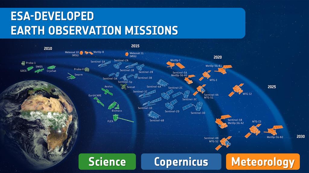
 Copernicus Space Component Status & Evolution ESCAP, Bangkok 09 October 2017 Simon Jutz Head of the ESA Copernicus Space Office Directorate of Earth Observation Programmes 28 satellites in development
Sentinel-1 Mission Status
 Sentinel-1 Mission Status Pierre Potin, Sentinel-1 Mission Manager, ESA Luca Martino, Technical Support Engineer, ESA... and the Sentinel-1 operations team PSTG SAR Coordination Working Group 14 December
Towards eenvironment Prague, March GMES Space Component. Josef Aschbacher Head, ESA GMES Space Office
 Towards eenvironment Prague, 25-27 March 2009 GMES Space Component Josef Aschbacher Head, ESA GMES Space Office Prague from Space Segment 2 05 Nov 2003 CNES 2003 GISAT 2007 ESA GSELAND GMES is an EU led
Copernicus the EU's Earth Observation Programme
 Copernicus the EU's Earth Observation Programme Cristina Ananasso Copernicus Unit I2 DG GROW Status Overview, Nov 2016 Horizon 2020 Info Day - Rome Follow us on: Copernicus EU CopernicusEU www.copernicus.eu
Status of ESA EO Programmes
 Status of ESA EO Programmes 54 th ESSC Plenary Meeting 24 November 2017 Maurice Borgeaud, ESA Head of the ESA Earth Observation Science, Applications and Climate Department Issue/Revision: 0.0 Reference:
Copernicus Overview and Emergency Management Service
 Copernicus Overview and Emergency Management Service Frédéric BASTIDE European Commission Open informal session of the United Nations Inter-Agency Meeting on Outer Space Activities 12 March 2013, Geneva
Emergency Management Service (EMS) mapping
 mapping") GMES Emergency Management Service (EMS) mapping Frédéric BASTIDE GMES unit, European Commission UN-SPIDER Expert Meeting: "Crowdsource Mapping for Disaster Risk Management and Emergency Response" 3-5 December,
GMES Emergency Management Service (EMS) mapping Frédéric BASTIDE GMES unit, European Commission UN-SPIDER Expert Meeting: "Crowdsource Mapping for Disaster Risk Management and Emergency Response" 3-5 December,
Marine Monitoring. The Copernicus Marine Service
 Marine The Copernicus Marine Service Why is the marine sector so important? Marine Blue Economy, 5 million jobs, gross added value almost 500bn/year 90% of international trade is maritime Half of the world's
ESA Status Report. ET-SAT-11, WMO, Geneva, CH, 4 April Prepared by Earth Observation Programmes Directorate
 ESA Status Report ET-SAT-11, WMO, Geneva, CH, 4 April 2017 Prepared by Earth Observation Programmes Directorate Presented by Ivan Petiteville, ESA, Earth Observation Programmes Issue/Revision: 0.0 Reference:
C o p e r n i c u s a n d W I G O S
 C o p e r n i c u s a n d W I G O S Jean-Noël Thépaut & Mark Dowell 24 October 2017 GEO XIV, Washington DC, 23-28 October 2017 T h e C o p e r n i c u s P r o g r a m m e Copernicus is the European Union
Space research. Horizon Work Programme. "Countdown to Horizon 2020 Space" Earth Observation topics. Brussels, 12 December 2013
 Space research Horizon 2020 - Work Programme "Countdown to Horizon 2020 Space" Earth Observation topics Brussels, 12 December 2013 richard.gilmore@ec.europa.eu Table of contents FP/Copernicus - general
C o p e r n i c u s M a r i n e S e r v i c e i n s u p p o r t t o s u s t a i n a b l e B l u e G r o w t h
 Implemented by C o p e r n i c u s M a r i n e S e r v i c e i n s u p p o r t t o s u s t a i n a b l e B l u e G r o w t h European Commission, DG MARE 19 Januray 2018 C O P E R N I C U S I N B R I E
The ESA Earth observation programmes overview and outlook
 The ESA Earth observation programmes overview and outlook Dr. Volker Liebig Director, ESA EO Programmes ILA 2008, Berlin ENVISAT mission: 6 years! Bam earthquake Tectonic uplift (Andaman) Arctic 2007 First
U s i n g t h e E S A / E U M E T C A S T N a v i g a t o r s
 U s i n g t h e E S A / E U M E T C A S T N a v i g a t o r s Copernicus User Uptake Information Sessions Copernicus EU Copernicus EU Copernicus EU www.copernicus.eu I N T R O D U C T I O N O F U S E C
Sentinel-1 Mission Status
 Sentinel-1 Mission Status Pierre Potin, Sentinel-1 Mission Manager 5TH GEOGLAM RAPP Workshop 16-17 May 2017, ESRIN Sentinel-1: Copernicus radar imaging mission for ocean, land, emergency Part of the Copernicus
Copernicus the European Space Programme for Earth Observation
 Copernicus the European Space Programme for Earth Observation http://www.copernicus.eu http://www.esa.int An Introduction Rome 2017 by Giorgio Bagnasco Issue/Revision: 0.0 Reference: ESA UNCLASSIFIED Status:
Infrastructure monitoring using SAR interferometry
 Infrastructure monitoring using SAR interferometry Hossein Nahavandchi Roghayeh Shamshiri Norwegian University of Science and Technology (NTNU), Department of Civil and Environmental Engineering Geodesy
CNES actions towards risk mitigation and climate change monitoring
 United nations / Germany International Conference: International cooperation Towards Low-Emission and Resilient Societies 22-24 Nov 2017, Bonn CNES actions towards risk mitigation and climate change monitoring
A c c e s s t o C o p e r n i c u s D a t a
 A c c e s s t o C o p e r n i c u s D a t a Overview and Introduction Copernicus EU Copernicus EU Copernicus EU www.copernicus.eu C O P E R N I C U S I N B R I E F Copernicus Copernicus, a flagship programme
ESA s Earth Observation Programmes
 ESA s Earth Observation Programmes 2015 DRAGON Symposium Interlaken, 23 June 2015 Maurice Borgeaud Head of the Department Science, Applications, and Future Technologies ESA Earth Observation Programmes
Copernicus Opportunities and Challenges in Europe s eyes on Earth
 Copernicus Opportunities and Challenges in Europe s eyes on Earth Gunter Schreier Deputy Director DLR German Remote Sensing Data Center - Earth Observation Center Rotterdam 25. Mai 2016 Sentinel - Missions
EuroGEOSS Protected Areas Pilot
 EuroGEOSS Protected Areas Pilot Max Craglia European Commission Joint Research Centre Part 1: the present MyNatura2000 Mobile app. Awareness raising & volunteered data collection. Natura2000 covers 18%
Geospatial Information and Services for Disasters (GIS4D)
") Geospatial Information and Services for Disasters (GIS4D) 31 July 2017 Tae Hyung KIM ICT and Disaster Risk Reduction Division (IDD) UNESCAP 1 About ESCAP Who is ESCAP? United Nations Economic and Social
Geospatial Information and Services for Disasters (GIS4D) 31 July 2017 Tae Hyung KIM ICT and Disaster Risk Reduction Division (IDD) UNESCAP 1 About ESCAP Who is ESCAP? United Nations Economic and Social
The Copernicus Sentinel-5 Mission: Daily Global Data for Air Quality, Climate and Stratospheric Ozone Applications
 SENTINEL-5 The Copernicus Sentinel-5 Mission: Daily Global Data for Air Quality, Climate and Stratospheric Ozone Applications Yasjka Meijer RHEA for ESA, Noordwijk, NL 15/04/2016 Co-Authors: Jörg Langen,
sentinel-3 A BIGGER PICTURE FOR COPERNICUS
 sentinel-3 A BIGGER PICTURE FOR COPERNICUS SATELLITES TO SERVE By providing a set of key information services for a wide range of practical applications, Europe s Copernicus programme has been put in place
A BRIEF INTRODUCTION TO COPERNICUS AND CAMS
 A BRIEF INTRODUCTION TO COPERNICUS AND CAMS Juan Garcés de Marcilla Director of Copernicus Services European Centre for Medium-Range Weather Forecasts Copernicus EU Copernicus EU Copernicus EU www.copernicus.eu
Supporting GPSC Cities with Satellite Earth Observation for Sustainable Urban Development
 Supporting GPSC Cities with Satellite Earth Observation for Sustainable Urban Development Global Platform for Sustainable Cities African Regional Workshop 14 May 2018 AfDB Headquarters Abidjan, Côte d'ivoire
COPERNICUS SPACE DATA OFFER FOR PUBLIC AUTHORITIES DISTRIBUTED BY ESA
 COPERNICUS SPACE DATA OFFER FOR PUBLIC AUTHORITIES DISTRIBUTED BY ESA The Copernicus Space Component Data Access (CSC-DA) service - financed by the EU and operated by ESA - grants National Public Authorities
T h e C o p e r n i c u s m a r i n e s e r v i c e. DG-GROW, Copernicus. Copernicus EU
 T h e C o p e r n i c u s m a r i n e s e r v i c e DG-GROW, Copernicus Copernicus EU Copernicus EU Copernicus EU www.copernicus.eu 2 W h y is t h e m a r i n e s e c t o r so i m p o r t a n t? Blue Economy,
Space Application in Support of Land Management for SDG Implementation
 Space Application in Support of Land Management for SDG Implementation Regional Expert Workshop on Land Accounting for SDG Monitoring and Reporting 26 September 2017 Space Application Section Information
Copernicus EMS: Αξιολόγηση πολλαπλών φυσικών κινδύνων - Σχεδιασμός και Ανάκτηση
 Building Capacity for a Centre of Excellence for EO-based monitoring of Natural Disasters Copernicus EMS: Αξιολόγηση πολλαπλών φυσικών κινδύνων - Σχεδιασμός και Ανάκτηση Γιάννης Παπουτσής ΙΑΑΔΕΤ Εθνικό
Copernicus Overview. Major Emergency Management Conference Athlone 2017
 Copernicus Overview Major Emergency Management Conference Athlone 2017 Copernicus is a European programme implemented by the European Commission. The services address six thematic areas: land, marine,
The Integrated Ge spatial Information Framework to the strengthening of NSDI, Mongolia
 Young Geospatial Professionals Summit 21 NOV 2018 The Integrated Ge spatial Information Framework to the strengthening of NSDI, Mongolia BAYARMAA ENKHTUR Geospatial information and technology department
EUMETSAT Climate Activities
 EUMETSAT Climate Activities Jörg Schulz EUMETSAT s Role in Climate Monitoring EUMETSAT has a prominent role in the world for providing services relevant to climate: EUMETSAT maintains some of the longest
EUMETSAT. A global operational satellite agency at the heart of Europe. Presentation for the Spanish Industry Day Madrid, 15 March 2012
 EUMETSAT A global operational satellite agency at the heart of Europe Presentation for the Spanish Industry Day Madrid, Angiolo Rolli EUMETSAT Director of Administration EUMETSAT objectives The primary
Status report on current and future satellite systems by EUMETSAT Presented to CGMS-44, Plenary session, agenda item D.1
 Status report on current and future satellite systems by EUMETSAT Presented to CGMS-44, Plenary session, agenda item D.1 CGMS-44-EUMETSAT-WP-19.ppt, version 1 (# 859110), 8 June 2016 MISSION PLANNING YEAR...
MONITORING THE ATMOSPHERE, OCEAN AND CLIMATE FROM SPACE
 MONITORING THE ATMOSPHERE, OCEAN AND CLIMATE FROM SPACE TRANSFORMING OUR WORLD MONITORING WEATHER AND CLIMATE FROM SPACE MONITORING THE ATMOSPHERE, OCEAN AND CLIMATE FROM SPACE FOR TRANSFORMING OUR WORLD
Essential Biodiversity Variables Workshop
 Essential Biodiversity Variables Workshop Dr. Maurice Borgeaud ESA Earth Observation Programmes ESA ESRIN 27 February 2012 The European Space Agency To provide for and promote, for exclusively peaceful
sentinel-2 COLOUR VISION FOR COPERNICUS
 sentinel-2 COLOUR VISION FOR COPERNICUS SATELLITES TO SERVE By providing a set of key information services for a wide range of practical applications, Europe s Copernicus programme is providing a step
A state of the art and user driven Copernicus service Physics and Biogeochemistry
 C M E M S P r e s e n t a n d F u t u r e R e q u i r e m e n t s f o r I n - S i t u a n d S a t e l l i t e O b s e r v a t i o n s Antonio REPPUCCI; Pierre Yves LE TRAON Mercator Ocean International
Earth Observation + Artificial Intelligence = Smart Society 2.0
 Earth Observation + Artificial Intelligence = Smart Society 2.0 Dag Anders Moldestad Norwegian Space Centre Dag.anders.moldestad@spacecentre.no 22 51 18 09 Automatic sea ice analysis based on AMSR2 & Sentinel-1
ADVANTAGES OF GIS-INTEGRATED MARITIME DATA IN THE BLACK SEA REGION FOR MULTIPURPOSE USE
 INTERAGENCY INTERACTION IN CRISIS MANAGEMENT AND DISASTER RESPONSE 2017 ADVANTAGES OF GIS-INTEGRATED MARITIME DATA IN THE BLACK SEA REGION FOR MULTIPURPOSE USE Lyubka Pashova 1, Anna Kortcheva 2, Vasko
The International Charter Space and Major Disasters is further strengthening its contribution to disaster management worldwide.
 28 September 2012 Issue 3 The International Charter Space and Major Disasters is further strengthening its contribution to disaster management worldwide. Building on a decade of success in making satellite
European Space Agency
 Guidelines - Guidelines how/when to interact during the WebEx session: - Due to the number of attendees, please keep always your webcam and microphone switched-off - You can use anytime the chat to all
COMBINING EUMETSAT AND SENTINEL MISSIONS TO CREATE NEW OPPORTUNITIES MONITORING WEATHER AND CLIMATE FROM SPACE
 COPERNICUS @EUMETSAT COMBINING EUMETSAT AND SENTINEL MISSIONS TO CREATE NEW OPPORTUNITIES MONITORING WEATHER AND CLIMATE FROM SPACE COPERNICUS A EUROPEAN RESPONSE TO THE CHALLENGE OF GLOBAL MONITORING
Status of EUMETSAT Operational Services & EUMETCast Africa Dissemination Baseline Updates
 Status of EUMETSAT Operational Services & EUMETCast Africa Dissemination Baseline Updates Sally Wannop User Relations Manager 1 8th WMO RAIDEG meeting 1-2 November 2017 # 951881 Overview EUMETCast Overview
National Remote Sensing Center of China. Space Technology for Sustainable Development in China Status, Achievements and Futures.
 National Remote Sensing Center of China Space Technology for Sustainable Development in China Status, Achievements and Futures Jing Li National Remote Sensing Center of China Ministry of Science and Technology,
Space Applications for Disaster Risk Reduction and Sustainable Development
 Space Applications for Disaster Risk Reduction and Sustainable Development Space Applications Section (SAS) ICT and Disaster Risk Reduction Division (IDD) UNESCAP Contents I. RESAP Activities 2016-2017
Oman NSDI Supporting Economic Development. Saud Al-Nofli Director of Spatial Data Directorate General of NSDI, NCSI
 Oman NSDI Supporting Economic Development 2017 Saud Al-Nofli Director of Spatial Data Directorate General of NSDI, NCSI "It s critical to make correct decisions the first time to optimize the Investments
Collaborative Systems for the Creation of Marine Services
 Collaborative Systems for the Creation of Marine Services INSPIRE 2016 Nuno Almeida Nuno Catarino Barcelona, 28 th September 2016 Elecnor Deimos is a trademark which encompasses Elecnor Group companies
Earth Observation and GEOSS in Horizon Copernicus for Raw Material Workshop 5 th September 2016
 Earth Observation and GEOSS in Horizon 2020 Copernicus for Raw Material Workshop 5 th September 2016 Gilles OLLIER Head of Sector -Earth observation Directorate Environment Unit I.4 Climate Actions and
The Copernicus Climate Change (C3) service: State of play
 service: State of play") Enterprise and Industry The Copernicus Climate Change (C3) service: State of play B. Pinty (a) & J-N. Thépaut (b) (a) Copernicus G.2 unit (b) ECMWF CCI October2014 Legal frame & MS consultations Publica6on
Enterprise and Industry The Copernicus Climate Change (C3) service: State of play B. Pinty (a) & J-N. Thépaut (b) (a) Copernicus G.2 unit (b) ECMWF CCI October2014 Legal frame & MS consultations Publica6on
Global Monitoring for Environment and Security (GMES)
") Global Monitoring for Environment and Security (GMES) Satellite Earth Observation for the Emergency Services Dr Nick Veck Presentation to the G-STEP Launch Univ. of Leicester 19 th June 2009 Contents of
Global Monitoring for Environment and Security (GMES) Satellite Earth Observation for the Emergency Services Dr Nick Veck Presentation to the G-STEP Launch Univ. of Leicester 19 th June 2009 Contents of
Urban areas & climate change
 Urban areas & climate change Paolo Gamba University of Pavia University of Pavia The UNIPV TLC & RS Lab is a dynamic research group developing in the past years many techniques devoted to the analysis
Earth Observation and Renewable Energy
 ESMAP Knowledge Exchange Forum 2013 November 21 The Hague, Netherlands Earth Observation and Renewable Energy Zoltan Bartalis Earth Observation Exploitation Engineer Science, Applications and Future Technologies
Cristina Ananasso Copernicus Unit DG GROW. H2020 Space: Calls on Earth Observation and Copernicus Ilan Ramon Conference 28/01/2018 Tel Aviv
 Cristina Ananasso Copernicus Unit DG GROW H2020 Space: Calls on Earth Observation and Copernicus Ilan Ramon Conference 28/01/2018 Tel Aviv OUTLINE Call Space 2018-2020 - Earth Observation and Copernicus
INSPIRE Directive. Status June 2007
 INSPIRE Directive INfrastructure for SPatial InfoRmation in Europe Status June 2007 European Commission Directorate-General Environment Research, Science and Innovation Unit Rue de la Loi, 200 1049 Brussels
Land Use in the context of sustainable, smart and inclusive growth
 Land Use in the context of sustainable, smart and inclusive growth François Salgé Ministry of sustainable development France facilitator EUROGI vice president AFIGéO board member 1 Introduction e-content+
INSPIRE Basics. Vlado Cetl European Commission Joint Research Centre. https://ec.europa.eu/jrc/
 INSPIRE Basics Vlado Cetl European Commission Joint Research Centre https://ec.europa.eu/jrc/ Serving society Stimulating innovation Supporting legislation Outline SDI? Why European SDI? INSPIRE Policy
Challenges and Successes in Sharing Geospatial Data in Africa
 Challenges and Successes in Sharing Geospatial Data in Africa 2018 GeoNode Summit Torino, Italy March 26-28, 2018 Bernard Justus Muhwezi Manager, Geo-Information Services Uganda Bureau of Statistics, Kampala,
GMES EURORISK Geo-information services for natural and man-made risks management
 GMES EURORISK Geo-information services for natural and man-made risks management 8/11/2004 EURORISK A European scale approach for developing, delivering and operationally exploiting new information services
Building Institutional Capacity for Multi-Hazard Early Warning in Pacific Countries Subtitle
 Building Institutional Capacity for Multi-Hazard Early Warning in Pacific Countries Subtitle Title Keran Wang Chief, Space Applications Section ICT and Disaster Risk Reduction Division 30 March 2018 Slide
Copernicus Space Component
 Copernicus Space Component Core and Collaborative Ground Segment, Operations Concept, Data Access Simon.Jutz (@esa.int) Head, Copernicus Space Office European Space Agency, Earth Observation Programmes
Thematic Session: IT Innovations Geospatial Approaches to Damage Assessment: The Example of Haiti Earthquake
 Thematic Session: IT Innovations Geospatial Approaches to Damage Assessment: The Example of Haiti Earthquake Date: 10/05/2011 Location: Geneva, Switzerland Name: Luca Dell Oro Title: Research Associate
CAN THO URBAN DEVELOPMENT AND RESILIENCE PROJECT
 CAN THO URBAN DEVELOPMENT AND RESILIENCE PROJECT 1 Phnom Penh Can Tho City HCM City EAST SEA 2 1 3 Highest Water Level WATER LEVEL RAISE IN CAN THO DURING LAST 40 YEARS 4 2 Land subsidence a threat that
EUMETSAT SAF NETWORK. Lothar Schüller, EUMETSAT SAF Network Manager
 1 EUMETSAT SAF NETWORK Lothar Schüller, EUMETSAT SAF Network Manager EUMETSAT ground segment overview METEOSAT JASON-2 INITIAL JOINT POLAR SYSTEM METOP NOAA SATELLITES CONTROL AND DATA ACQUISITION FLIGHT
Julia Figa-Saldaña & Klaus Scipal
 Julia Figa-Saldaña & Klaus Scipal julia.figa@eumetsat.int klaus.scipal@esa.int Meeting, Outline MetOp/EPS status MetOp/EPS Second Generation status 2016 scatterometer conference Other European ocean programme
GEOMATICS AND DISASTER MANAGEMENT: Early Impact assessment in Haiti
 GEOMATICS AND DISASTER MANAGEMENT: Early Impact assessment in Haiti We will talk about... Post-disaster response: the main questions to be answered Post-disaster rapid mapping: the role of Geomatics The
FINDINGS OF THE ARCTIC METEOROLOGY SUMMIT
 FINDINGS OF THE ARCTIC METEOROLOGY SUMMIT 2018 WWW.FMI.FI CHAIR S SUMMARY: 1 2 3 We need to be curious to explore the known unknowns. Meteorology is an elemental part of international collaboration in
International Conference Analysis and Management of Changing Risks for Natural Hazards November 2014 l Padua, Italy
 Abstract Code: B01 Assets mapping products in support of preparedness and prevention measures (examples from Germany, Italy and France) Marc Mueller, Thierry Fourty, Mehdi Lefeuvre Airbus Defence and Space,
EUMETSAT Satellite Status
 EUMETSAT Satellite Status Dr. K. Dieter Klaes EUMETSAT 1 ET-SAT Meeting 4-6 April 2017, WMO, Geneva, Switzerland EUMETSAT is an intergovernmental organisation with 30 Member States and 1 Cooperating State
AUTOMATED DATA PROCESSING FOR MARITIME AND FLOODS APPLICATIONS
 YOUR HUB FOR GEOSPATIAL APPLICATIONS AUTOMATED DATA PROCESSING FOR MARITIME AND FLOODS APPLICATIONS Angelucci Maria, Daffina Filippo, Grandoni Domenico, Quattrociocchi Dino Automated Data Processing (Smart
EUMETSAT Beitrag zu CAMS und C3S. Jörg Schulz. Credits to many EUMETSAT Staff
 ETSAT Beitrag zu CAMS und C3S Jörg Schulz Credits to many ETSAT Staff The Copernicus Programme at ETSAT ETSAT is entrusted by the European Commission; ETSAT s Delegation Agreement is organised in 3 major
UN-GGIM: Strengthening Geospatial Capability
 Fifth Plenary Meeting of UN-GGIM: Europe Brussels, 6-7 June 2018 UN-GGIM: Strengthening Geospatial Capability Walking the talk to leave no one behind Greg Scott, UN-GGIM Secretariat Environmental Statistics
Commercialisation. Lessons learned from Dutch weather market
 Commercialisation Lessons learned from Dutch weather market Where information comes together weather traffic public transport Weather, traffic and public transport. Daily actual information that influences
GMES Service for Geospatial Reference Data Access (RDA) Covering Areas Outside Europe
 Covering Areas Outside Europe") INSPIRE Conference 2011 Edinburgh 27 June - 1 July GMES Service for Geospatial Reference Data Access (RDA) Covering Areas Outside Europe Andrea Ajmar, Simone Balbo, Piero Boccardo, Simone Dalmasso, Anna
INSPIRE Conference 2011 Edinburgh 27 June - 1 July GMES Service for Geospatial Reference Data Access (RDA) Covering Areas Outside Europe Andrea Ajmar, Simone Balbo, Piero Boccardo, Simone Dalmasso, Anna
Climate Change. Climate Change Service
 Service The C3S m ission To support European adaptation and mitigation policies by: Providing consistent and authoritative information about climate Building on existing capabilities and infrastructures
The Future of Remote Sensing
 The Future of Remote Sensing BELSPO - 30 Years of Remote Sensing Research 17 September 2015, Brussels Research and Michael Berger Earth Observation Sector Directorate Climate Action and Resource Efficiency
RESAP Progress Report
 RESAP Progress Report December 2016 to October 2017 Presentation to the Twenty-first session of the Intergovernmental Consultative Committee on the Regional Space Applications Programme for Sustainable
Overview and Status of ESA Earth Observation Programmes
 Overview and Status of ESA Earth Observation Programmes Maurice Borgeaud, ESA Head of the Science, Applications and Future Technologies Department Directorate of Earth Observation Programmes ADM-Aeolus
Geospatial framework for monitoring SDGs/Sendai targets By Shimonti Paul Sr. Assistant Editor Geospatial Media & Communications
 Geospatial framework for monitoring SDGs/Sendai targets By Shimonti Paul Sr. Assistant Editor Geospatial Media & Communications Outline 1. Introduction to Geospatial Media and Communications 2. Geospatial
Green areas: numerous positive effects for sustainable metropolis Satellite images : an easy way to map vegetation
 Green areas: numerous positive effects for sustainable metropolis Satellite images : an easy way to map vegetation Copernicus Training and Information Session 10 and 11 may 2017 in Lund, Sweden Dominique
Status of EUMETSAT Current and Future Programmes
 Status of EUMETSAT Current and Future Programmes Ernst Koenemann Director Programme Development Spanish Industry Day 15 th Slide: 1 Brief Status of MSG and EPS All operational Missions are performing as
SENTINEL 1 Mission status and contribution to PSTG
 PSTG SAR WG meeting, 12 September 2016, ESTEC SENTINEL 1 Mission status and contribution to PSTG First Sentinel1B Images 28 April 2016 Sentinel-1B Launch from Kourou, 25 April 2016 Sentinel 1 Mission Operations
Space for Sustainable Development
 Space for Sustainable Development ESA s contribution to the Where, What, and How of Data Dr. Christoph Aubrecht Directorate of Earth Observation Programmes Science, Applications and Future Technologies
Introduction to Space Weather in ARTES Applications Added Value of IAP Space Weather Activities
 Introduction to Space Weather in ARTES Applications Added Value of IAP Space Weather Activities TIA-APS 25/04/2016 Issue/Revision: 1. Reference: ESA-TIAA-HO-2016-0828 Status: Draft Introduction IAP stands
NOAA Surface Weather Program
 NOAA Surface Weather Program Maintenance Decision Support System Stakeholder Meeting #9 Jim O Sullivan NOAA Surface Weather Program Manager NWS Office of Climate, Water, and Weather Services September
SDI Development in Georgia. Mari Khardziani Head of International Relations Unit National Agency of Public Registry
 SDI Development in Georgia Mari Khardziani Head of International Relations Unit National Agency of Public Registry Kehl, Germany September 5, 2017 2 National Agency of Public Registry Legal Entity of Public
An Eye in the Sky EUMETSAT. Monitoring Weather, Climate and the Environment
 An Eye in the Sky EUMETSAT Monitoring Weather, Climate and the Environment Slide: 1 Hazardous Weather Slide: 2 Hazardous Weather Slide: 3 Natural Disasters set off by severe weather Slide: 4 EUMETSAT Objectives...
EU collaborations with NASA LCLUC Program & Current Priorities
 & Current Priorities ioannis Manakos, Dr. Centre for Research and Technology Hellas Information Technologies Institute Visual Analytics, Virtual & Augmented Reality Laboratory European Association of Remote
Securing EUMETSAT s Mission from an Evolving Space Environment
 Securing EUMETSAT s Mission from an Evolving Space Environment ESPI 12 th Autumn Conference Andrew Monham 1 EUMETSAT: Intergovernmental Organisation of 30 Member States Presentation Contents AUSTRIA BELGIU
VNREDSat-1. Vietnam Natural Resources, Environment and Disaster monitoring Satellite. Lai Anh Khoi SPACE TECHNOLOGY INSTITUTE
 VNREDSat-1 Vietnam Natural Resources, Environment and Disaster monitoring Satellite Lai Anh Khoi SPACE TECHNOLOGY INSTITUTE JPTM2014 Yangon, Nov. 19-21, 2014 General information (1) Project Owner: Vietnam
Towards best practices for using satellite Earth Observation in mining and extractives
 Towards best practices for using satellite Earth Observation in mining and extractives EU-Latin America Mining & Exploration Convention and Trade Show METS 2018 11 April 2018 Madrid Marriott Auditorium
Open Cities Project. The World Bank, South Asia Region. Background
 Open Cities Project The World Bank, South Asia Region Opencitiesproject.com Background The World Bank s South Asia Region (SAR) is proud to announce its new Open Cities Project. The goal of this project