Geospatial framework for monitoring SDGs/Sendai targets By Shimonti Paul Sr. Assistant Editor Geospatial Media & Communications
|
|
|
- Suzan Small
- 5 years ago
- Views:
Transcription
1 Geospatial framework for monitoring SDGs/Sendai targets By Shimonti Paul Sr. Assistant Editor Geospatial Media & Communications
2 Outline 1. Introduction to Geospatial Media and Communications 2. Geospatial and Sendai Framework and the SDGs 3. Case Studies 4. What more needs to be done
3 Geospatial Media & Communications
4
5
6 GEOSPATIAL LANDSCAPE
7 UN Sendai Framework- The Seven Global Targets- 18 March 2015 By 2030: Reduce Global disaster mortality Number of affected people globally Disaster economic loss Disaster damage to critical infrastructure and disruption of basic services Enhance Number of countries with national and local disaster risk reduction strategies. International cooperation to developing countries for implementation of this Framework Access to early warning systems and disaster risk information to people
8 Four Priorities of Action Understanding disaster risk Strengthening disaster risk governance Investing in disaster risk reduction Enhancing disaster preparedness for effective response


9 Opportunities with Geospatial Risk detection & Analysis Better Rebuilding Geospatial information & technology Faster & better decisions Lesser Loss Prevention
10 Case Study-INCOIS Indian National Centre for Ocean Information Developed a Tsunami Early Warning System Since October 2007 watching the undersea earthquakes and possible tsunamis in the Indian Ocean region and providing timely warnings.

11 We have heard how other countries are also adopting geospatial technologies for DRR. SriLanka s early warning systems. How they are using satellite imagery and LiDar for better disaster risk management.
12 UNGGIM- established by UN ECOSOC United Nations Committee of Experts on Global Geospatial Information Management (UNGGIM) In July 2011 as the official consultative mechanism on global geospatial information management. Playing a vital role in making geospatial information available and accessible across developing countries. Published Strategic Framework on Geospatial Information and Services for Disaster

13 UN Sustainable Development Goals UN adopted 17 Sustainable Development Goals, on January 1, 2016.
14 Monitoring SDGs The Indicators and Monitoring Framework for the SDGs: Have highlighted the opportunities and promise of a data revolution for the SDGs Establishment of a Global Partnership for Sustainable Development Data, to help drive the Data Revolution.
15
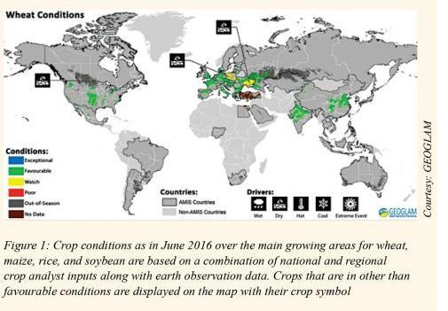
16 Earth observations allow crop monitoring Such monitoring helps in identifying anomalies and early insights Leads to taking corrective actions soon. Keeps food supply in control. Alternatives can be thought early.
17
18 Goal 3: Ensure healthy lives and promote well-being for all Geospatial analysis aid in getting answers to questions like: Where and what are the health care services? How well are they linked with the community demand? Mapping the two. These answers lead to faster and better decisions for improved living.
19 Checking chikungunya virus outbreak across the Caribbean Geospatial applications for smart phones assist the Ministry of Health in Trinidad and Tobago to: Identify location of persons infected Deploy teams to eradicate the mosquito that carries the virus Initiate social programs in these areas to inform persons on protective measures.

20 Goal 6 - Application of EO in wastewater monitoring
21 Goal 13: Climate Action Geospatial technologies provide visual proof/ visualization of extreme weather conditions, melting glaciers, dying corals etc. Mapping patterns of sea level rising is helping scientists determine the catastrophes that cimate changes will bring..
22
23 Conclusion All the examples reveal geospatial technologies can do wonders when it comes to DRR and preparedness for SDGs. It can help in identifying what needs to be done where faster. Better monitoring and effective outcomes.
24 Conclusion For better results we need better : Collaboration Awareness Data availability and accessibility Investing and training in newer technologies is the key.
25 Thank You
Geospatial Information Management in the Americas: Lessons for the Post-2015 development agenda
 Geospatial Information Management in the Americas: Lessons for the Post-2015 development agenda Rolando Ocampo President, UN-GGIM: Americas October 2014 The integration of statistical and geographical
KUNMING FORUM ON UNITED NATIONS GLOBAL GEOSPATIAL INFORMATION MANAGEMENT CITIES OF THE FUTURE: SMART, RESILIENT
 KUNMING FORUM ON UNITED NATIONS GLOBAL GEOSPATIAL INFORMATION MANAGEMENT CITIES OF THE FUTURE: SMART, RESILIENT and SUSTAINABLE Yunnan Zhenzhuang Guest House, Kunming, China 10 12 May 2017 BACKGROUND CONCEPT
Disaster Management & Recovery Framework: The Surveyors Response
 Disaster Management & Recovery Framework: The Surveyors Response Greg Scott Inter-Regional Advisor Global Geospatial Information Management United Nations Statistics Division Department of Economic and
Space Application in Support of Land Management for SDG Implementation
 Space Application in Support of Land Management for SDG Implementation Regional Expert Workshop on Land Accounting for SDG Monitoring and Reporting 26 September 2017 Space Application Section Information
RESAP Progress Report
 RESAP Progress Report December 2016 to October 2017 Presentation to the Twenty-first session of the Intergovernmental Consultative Committee on the Regional Space Applications Programme for Sustainable
Geospatial Information and Services for Disasters (GIS4D)
") Geospatial Information and Services for Disasters (GIS4D) 31 July 2017 Tae Hyung KIM ICT and Disaster Risk Reduction Division (IDD) UNESCAP 1 About ESCAP Who is ESCAP? United Nations Economic and Social
Geospatial Information and Services for Disasters (GIS4D) 31 July 2017 Tae Hyung KIM ICT and Disaster Risk Reduction Division (IDD) UNESCAP 1 About ESCAP Who is ESCAP? United Nations Economic and Social
UN-GGIM: Strengthening Geospatial Capability
 Fifth Plenary Meeting of UN-GGIM: Europe Brussels, 6-7 June 2018 UN-GGIM: Strengthening Geospatial Capability Walking the talk to leave no one behind Greg Scott, UN-GGIM Secretariat Environmental Statistics
Bengt Kjellson Chair of the Executive Committee UN-GGIM: Europe. 2 nd Joint UN-GGIM: Europe ESS Meeting 11 th March 2016, Luxembourg
 Bengt Kjellson Chair of the Executive Committee UN-GGIM: Europe 2 nd Joint UN-GGIM: Europe ESS Meeting 11 th March 2016, Luxembourg A global geospatial mandate At its 47th plenary in July 2011, ECOSOC,
Implementing the Sustainable Development Goals: The Role of Geospatial Technology and Innovation
 Fifth High Level Forum on UN Global Geospatial Information Management Implementing the Sustainable Development Goals: The Role of Geospatial Technology and Innovation 28-30 November 2017 Sheraton Maria
FINDINGS OF THE ARCTIC METEOROLOGY SUMMIT
 FINDINGS OF THE ARCTIC METEOROLOGY SUMMIT 2018 WWW.FMI.FI CHAIR S SUMMARY: 1 2 3 We need to be curious to explore the known unknowns. Meteorology is an elemental part of international collaboration in
Measuring Disaster Risk for Urban areas in Asia-Pacific
 Measuring Disaster Risk for Urban areas in Asia-Pacific Acknowledgement: Trevor Clifford, Intl Consultant 1 SDG 11 Make cities and human settlements inclusive, safe, resilient and sustainable 11.1: By
REPUBLIC OF ZAMBIA STATEMENT THE HONOURABLE LUCKY MULUSA, M.P., MINISTER OF NATIONAL DEVELOPMENT PLANNING,
 REPUBLIC OF ZAMBIA Permanent Mi$sion of Zambia to the United Nations, 237 East 52nd Street, New York, NY 10022 Tex: (212) 888-5770 Fax: (212) 888-5213 E-mail: zambia@un.int Please check against delivery
PUBLIC HEALTH ASSOCIATION OF AUSTRALIA Strategic Plan
 PUBLIC HEALTH ASSOCIATION OF AUSTRALIA Strategic Plan March 2017 20 Napier Close Deakin ACT Australia 2600 PO Box 319 Curtin ACT Australia 2605 Table of Contents Introduction... 2 Vision for a healthy
Integration for Informed Decision Making
 Geospatial and Statistics Policy Intervention: Integration for Informed Decision Making Greg Scott Global Geospatial Information Management United Nations Statistics Division Department of Economic and
By Lillian Ntshwarisang Department of Meteorological Services Phone:
 By Lillian Ntshwarisang Department of Meteorological Services Phone: +267 3612200 Email: lntshwarisang@gov.bw/ lntshwarisang@gmail.com Introduction Mandate of DMS Function of the Department Services to
Background Document: Report of the Regional Committee of United Nations Global Geospatial Information Management for Asia and the Pacific
 Background Document: Report of the Regional Committee of United Nations Global Geospatial Information Management for Asia and the Pacific 1. Summary 1. This report highlights the activities carried out
SDG s and the role of Earth Observation
 SDG s and the role of Earth Observation Christian Heipke IPI - Institute for Photogrammetry and GeoInformation Leibniz Universität Hannover Germany Secretary General, ISPRS 1. No Poverty 2. Zero Hunger
UN GGIM and National SDI Strategy
 MSDI Open Forum on 26 th January 2016 Contributing to the successful delivery of MSDI UN GGIM and National SDI Strategy Hiroshi Murakami Deputy Administrator Geospatial Information Authority of Japan Geospatial
Building Institutional Capacity for Multi-Hazard Early Warning in Asia and the Pacific Subtitle
 Building Institutional Capacity for Multi-Hazard Early Warning in Asia and the Pacific Subtitle Title Keran Wang Chief, Space Applications Section ICT and Disaster Risk Reduction Division 22 May 2018 Pillar
Egypt-NOAA Cooperation: Advancing our Environmental Science, Technology, and Education
 Egypt-NOAA Cooperation: Advancing our Environmental Science, Technology, and Education T. G. Onsager NOAA Space Weather Prediction Center and NWS International Activities Office (one-year detail) Terry.Onsager@noaa.gov
2018/1 The integration of statistical and geospatial information. The Regional Committee of UN-GGIM: Americas:
 The following are the conclusions and recommendations of the Regional Committee of the United Nations on Global Geospatial Information Management for the Americas, during its Fifth Session, Thursday 8
Presentation by Thangavel Palanivel Senior Strategic Advisor and Chief Economist UNDP Regional Bureau for Asia-Pacific
 Presentation by Thangavel Palanivel Senior Strategic Advisor and Chief Economist UNDP Regional Bureau for Asia-Pacific The High-Level Euro-Asia Regional Meeting on Improving Cooperation on Transit, Trade
Seabed knowledge In support of UN SDGs
 Seabed knowledge In support of UN SDGs Evert Flier Fiskerifaglig forum 2. november 2017 Hydrography & small scale fishing Hydrography in Transition Serving the Maritime Community Hydrography in Transition
The Integrated Ge spatial Information Framework to the strengthening of NSDI, Mongolia
 Young Geospatial Professionals Summit 21 NOV 2018 The Integrated Ge spatial Information Framework to the strengthening of NSDI, Mongolia BAYARMAA ENKHTUR Geospatial information and technology department
Dr. Biliana Cicin-Sain President, Global Ocean Forum 1
 Towards a Sustainable Development Goal on Oceans and Seas: Healthy, Productive and Resilient Oceans and Seas- Prosperous and Resilient Peoples and Communities Dr. Biliana Cicin-Sain President, Global Ocean
Economic and Social Council
 United Nation E/C.20/2012/4/Add.1 Economic and Social Council Distr.: General 2 July 2012 Original: English Committee of Experts on Global Geospatial Information Management Second session New York, 13-15
Geospatial application in Kiribati
 Geospatial application in Kiribati ICC-21 ST RESAP (9 TH TO 13 TH OCTOBER, 2017) BANGKOK, THAILAND Outline Kiribati Profile Natural disasters in Kiribati Achievements Challenges/Issues Ways forward 1 Kiribati
Concept note. High-Level Seminar: Accelerating Sustainable Energy for All in Landlocked Developing Countries through Innovative Partnerships
 Concept note High-Level Seminar: Accelerating Sustainable Energy for All in Landlocked Developing Countries through Innovative Partnerships Date: 24 and 25 October 2016 Venue: Conference Room C3, Vienna
Briefing. H.E. Mr. Gyan Chandra Acharya
 Briefing by H.E. Mr. Gyan Chandra Acharya Under-Secretary-General and High Representative for the Least Developed Countries, Landlocked Developing Countries and Small Island Developing States Briefing
Empowered lives. Resilient nations. Data for People and Planet. powered by
 Empowered lives. Resilient nations. Data for People and Planet powered by Overview As we enter the fourth industrial revolution, technology is revolutionizing our ability to map nature. Satellite data
Strategic Framework on Geospatial Information and Services for Disasters
 Strategic Framework on Geospatial Information and Services for Disasters Case Studies for the Caribbean and the Philippines --- Kunming Forum on United Nations Global Geospatial Information Management
Global Map: A Tool for Disaster Mitigation for the Asia and Pacific Region
 Global Map: A Tool for Disaster Mitigation for the Asia and Pacific Region D. R. Fraser Taylor Chair, International Steering Committee for Global Mapping (ISCGM) fraser_taylor@carleton.ca www. 18 th United
Geographic Information Infrastructure and Policy Framework for Sustainable Mountain Development in the Hindu Kush-Himalayas
 Geo SMART ASIA 2017 22-24 August, Kualalampur Geographic Information Infrastructure and Policy Framework for Sustainable Mountain Development in the Hindu Kush-Himalayas Basanta Shrestha, Director Strategic
Economic and Social Council
 United Nations Economic and Social Council Distr.: General 2 July 2012 E/C.20/2012/10/Add.1 Original: English Committee of Experts on Global Geospatial Information Management Second session New York, 13-15
Economic and Social Council
 United Nations Economic and Social Council Distr.: General 18 July 2016 Original: English Committee of Experts on Global Geospatial Information Management Sixth session New York, 3-5 August 2016 Item 2
Coastal Inundation Forecasting Demonstration Project CIFDP. Flood Forecasting Initiative-Advisory Group (FFI-AG 3), Geneva, 5-7 Dec, 2017
, Geneva, 5-7 Dec, 2017") Coastal Inundation Forecasting Demonstration Project CIFDP Flood Forecasting Initiative-Advisory Group (FFI-AG 3), Geneva, 5-7 Dec, 2017 Coastal Flooding & Vulnerable Populations Coastal populations are
Coastal Inundation Forecasting Demonstration Project CIFDP Flood Forecasting Initiative-Advisory Group (FFI-AG 3), Geneva, 5-7 Dec, 2017 Coastal Flooding & Vulnerable Populations Coastal populations are
Geospatial Technologies for Resources Planning & Management
 Geospatial Technologies for Resources Planning & Management Lal Samarakoon, PhD Director, Geoinformatics Center Asian Institute of Technology, Thailand Content Geoinformatics for SDG Information Integration
International Union of Geodesy and Geophysics. Resolutions
 International Union of Geodesy and Geophysics Resolutions ADOPTED BY THE COUNCIL AT THE XXVI GENERAL ASSEMBLY PRAGUE, CZECH REPUBLIC (22 JUNE 2 JULY 2015) 0 Page Resolution 1: Role of Ocean in Climate
WMO. Early Warning System
 World Meteorological Organization Working together in weather, climate and water WMO Tropical Cyclone Early Warning System Koji Kuroiwa Tropical Cyclone Programme World Meteorological Organization For
Foundation Geospatial Information to serve National and Global Priorities
 Foundation Geospatial Information to serve National and Global Priorities Greg Scott Inter-Regional Advisor Global Geospatial Information Management United Nations Statistics Division UN-GGIM: A global
Impact of Cyclone Nargis
 Lessons Learnt from Nargis Recovery for the Next Disaster International Recovery Forum (2011) 12, JAN 2011, Kobe, Japan Home for over 100 national races. Profile of Myanmar The 2 nd largest country in
ECONOMIC AND SOCIAL COUNCIL
 UNITED NATIONS E/CONF.102/3 ECONOMIC AND SOCIAL COUNCIL Nineteenth United Nations Regional Cartographic Conference for Asia and the Pacific Bangkok, 29 October 1 November 2012 Item 4 of the provisional
GENERAL RECOMMENDATIONS. Session 7. Breakout discussion. discuss on regional and interregional. proposals 1. COLLABORATION BETWEEN PROGRAMMES
 Session 7 24 July 2016, 9.00-11.00 Breakout discussion on regional and interregional joint project proposals Mr Shahbaz Khan summarized the two days of presentations and exchanges and requested the participants
Building Institutional Capacity for Multi-Hazard Early Warning in Pacific Countries Subtitle
 Building Institutional Capacity for Multi-Hazard Early Warning in Pacific Countries Subtitle Title Keran Wang Chief, Space Applications Section ICT and Disaster Risk Reduction Division 30 March 2018 Slide
The Global Statistical Geospatial Framework and the Global Fundamental Geospatial Themes
 The Global Statistical Geospatial Framework and the Global Fundamental Geospatial Themes Sub-regional workshop on integration of administrative data, big data and geospatial information for the compilation
ESCAP Promotes Geo-referenced Information System for Disaster Risk Management in Asia and the Pacific
 Third High Level Forum on UNGGIM 22-24 October 2014 Beijing, China ESCAP Promotes Geo-referenced Information System for Disaster Risk Management in Asia and the Pacific Keran Wang Space Applications Section,
17 th Session of RA IV
 17 th Session of RA IV Agenda Item 4.1: Disaster Risk Reduction, Resilience and Prevention, Focusing on Impact-Based Decision Support Services Doc 4.1.(6):Coastal Inundation Forecasting Demonstration Project
World Meteorological Organization
 World Meteorological Organization Opportunities and Challenges for Development of Weather-based Insurance and Derivatives Markets in Developing Countries By Maryam Golnaraghi, Ph.D. Head of WMO Disaster
Lorna V Inniss, Ph.D SAGE Workshop, New York City
 Lorna V Inniss, Ph.D SAGE Workshop, New York City 2014-05-21 Why me? The globally recognized success of the Barbados ICZM programme has generated requests for technical assistance and CD from many Governments
Assessment Objectives Grid for Geography - G1. Summer Application Skills Total. (a) (b) (c) (a)
 (b) (c) (a)") Assessment Objectives Grid for Geography - G1 Summer 2014 Question 1 Knowledge and Understanding Application Skills Total Key Question (a) 0 2 3 5 1.5 (b) 8 2 10 1.3 (c) 7 3 10 1.4 15 7 3 25 Question 2
Assessment Objectives Grid for Geography - G1 Summer 2014 Question 1 Knowledge and Understanding Application Skills Total Key Question (a) 0 2 3 5 1.5 (b) 8 2 10 1.3 (c) 7 3 10 1.4 15 7 3 25 Question 2
Working Group on Geospatial Information
 GEO-XIV Plenary Summary Working Group on Geospatial Information 4 th Meeting Lawrence Friedl Argyro Kavvada Group on Earth Observations NASA Earth Science Dec. 6-8, 2017 An intergovernmental organization
Executive Summary and Recommendations
 ANNEX I: EXECUTIVE SUMMARY AND RECOMMENDATIONS OF THE 12RMSD TWELFTH REGIONAL MEETING OF THE METEOROLOGICAL SERVICE DIRECTORS 30 -JUNE to 6 -JULY 2007 Rarotonga, Cook Islands Executive Summary and Recommendations
JCOMM-CHy Coastal Inundation Forecasting Demonstration Project (CIFDP)
") WMO World Meteorological Organization Working together in weather, climate and water JCOMM-CHy Coastal Inundation Forecasting Demonstration Project (CIFDP) Coastal Flooding & Vulnerable Populations Coastal
WMO World Meteorological Organization Working together in weather, climate and water JCOMM-CHy Coastal Inundation Forecasting Demonstration Project (CIFDP) Coastal Flooding & Vulnerable Populations Coastal
Pacific Geospatial and Surveying Council (PGSC) Geospatial and GNSS CORS Infrastructure Forum. Kuala Lumpur October
 Geospatial and GNSS CORS Infrastructure Forum. Kuala Lumpur October") Pacific Geospatial and Surveying Council (PGSC) Geospatial and GNSS CORS Infrastructure Forum. Kuala Lumpur 16-17 October Beginning and Progress Members PGSC Charter PGSC Strategy 2017-2027 Meetings Geodetic
Pacific Geospatial and Surveying Council (PGSC) Geospatial and GNSS CORS Infrastructure Forum. Kuala Lumpur 16-17 October Beginning and Progress Members PGSC Charter PGSC Strategy 2017-2027 Meetings Geodetic
Experiences on Data and Observational Requirements in the Caribbean
 Experiences on Data and Observational Requirements in the Caribbean UNFCCC Expert Workshop on Methods & Tools and on Data & Observations under the NWP on Impacts, Vulnerability & Adaptation to Climate
Journey of supporting CSNs to establish Geo-DRM
 Regional Workshop on Geo-referenced Information Systems for Disaster Risk Management (Geo-DRM) 26-27 June 2014 Bangkok, Thailand Journey of supporting CSNs to establish Geo-DRM Keran Wang Chief, Space
Strategic Framework on Geospatial Information and Services for Disasters Relevance for the Americas Region
 Strategic Framework on Geospatial Information and Services for Disasters Relevance for the Americas Region Seventh Session of the Committee of Experts on UN-GGIM Side Event --- UN Headquarters, New York
Use of geo-referenced data for DRM in Central Asia, problems and prospective
 Use of geo-referenced data for DRM in Central Asia, problems and prospective Dr. Akylbek Chymyrov Director, Kyrgyz Center of Geoinformation Systems Member of the Public Supervisory Board MES KR KSUCTA,
COORDINATION WITH OTHER ACTIVITIES OF THE WMO TROPICAL CYCLONE PROGRAMME. (Submitted by the WMO Secretariat) Summary and Purpose of Document
 Summary and Purpose of Document") ESCAP/WMO TYPHOON COMMITTEE FORTY-NINTH SESSION 21-24 FEBRUARY 2017 YOKOHAMA, JAPAN FOR PARTICIPANTS ONLY WRD/TC.49/16 13 February 2017 ENGLISH ONLY COORDINATION WITH OTHER ACTIVITIES OF THE WMO TROPICAL
ESCAP/WMO TYPHOON COMMITTEE FORTY-NINTH SESSION 21-24 FEBRUARY 2017 YOKOHAMA, JAPAN FOR PARTICIPANTS ONLY WRD/TC.49/16 13 February 2017 ENGLISH ONLY COORDINATION WITH OTHER ACTIVITIES OF THE WMO TROPICAL
Manual of Digital Earth
 V8.0 March 27, 2018 International Society for Digital Earth Manual of Digital Earth (Tentative Title) OUTLINE Foreword Chapter 1 Understanding Digital Earth 1.1 Origins and Precursors of Digital Earth
PUBLIC WEATHER SERVICES
 WMO AGENDA ITEM 2.1(1) PUBLIC WEATHER SERVICES Gerald Fleming Chair, OPAG/PWS (Paraguay 8-12 September 2014) WMO - Public Weather Services, WDS WMO Summary CBS requested to make decisions on: Adopt Draft
Disaster Risk Reduction in Survey for Seismic Protection of MES
 Survey for Seismic Protection Ministry of Emergency Situations of Republic of Armenia Disaster Risk Reduction in Survey for Seismic Protection of MES Syuzanna Kakoyan Leading specialist at the Department
Background and History
 p1 Background and History What is the Indian Ocean Climate Initiative? The Indian Ocean Climate Initiative (IOCI) is a strategic program of research and information transfer to support government decision-making.
A/AC.105/C.1/2012/CRP.10
 A/AC.105/C.1/2012/CRP.10 1 February 2012 English only Committee on the Peaceful Uses of Outer Space Scientific and Technical Subcommittee Forty-ninth session Vienna, 6-17 February 2012 Item 6 of the provisional
Overview of Early Warning Systems and the role of National Meteorological and Hydrological Services
 Overview of Early Warning Systems and the role of National Meteorological and Hydrological Services South Africa Second Experts Symposium on Multi-Hazard Early Warning Systems With focus on the Role of
Progress on the Development of the Strategic Framework on Geospatial Information and Services for Disasters
 Progress on the Development of the Strategic Framework on Geospatial Information and Services for Disasters Dr. Peter N. Tiangco Administrator, NAMRIA, Philippines Co-chair, Working Group on Geospatial
Second Administrative Level Boundaries (SALB) initiative & geographic names in cartography. Geospatial Information Section
 initiative & geographic names in cartography. Geospatial Information Section") Second Administrative Level Boundaries (SALB) initiative & geographic names in cartography Geospatial Information Section Introduction Goals Global agenda How does SALB work? Latest News on geographic
Second Administrative Level Boundaries (SALB) initiative & geographic names in cartography Geospatial Information Section Introduction Goals Global agenda How does SALB work? Latest News on geographic
Please give me the background details of the warning system the US had before and the new improvements now.
 ----- Original Message ----- From: VADM Conrad C. Lautenbacher Jr., USN (Ret.) To: Announcement@noaa.gov Sent: Friday, January 28, 2005 1:30 PM Subject: Message from the Under Secretary -- NOAA Tsunami
SUSTAINABLE OCEANS GOVERNANCE:: NEW APPROACHES. Oceans Governance: Shaping our Future Workshop USP, 1-2 December 2016
 SUSTAINABLE OCEANS GOVERNANCE:: NEW APPROACHES Oceans Governance: Shaping our Future Workshop USP, 1-2 December 2016 WHAT IS SUSTAINABLE OCEAN GOVERNANCE? O C E A N G O V E R N A N C E I S T H E C O N
SOP of PTWC as a Regional Tsunami Service Provider
 UNESCO IOC CTIC US NOAA ITIC Regional Training Workshop on Strengthening Tsunami Warning and Emergency Response Standard Operating Procedures and the Development of the ICG/CARIBE-EWS PTWC New Enhanced
Geospatial natural disaster management
 Geospatial natural disaster management disasters happen. are you ready? Natural disasters can strike almost anywhere at any time, with no regard to a municipality s financial resources. These extraordinarily
ISSUES BRIEF Plenary A Risk-informed Approach to Sustainable Development and Resilience for Countries in Special Situations
 ISSUES BRIEF Plenary A Risk-informed Approach to Sustainable Development and Resilience for Countries in Special Situations Rationale All recent international agreements, including the Sendai Framework
Report on the establishment of UN GGIM: Europe Item 14. 4th session of the Committee of Experts on UN-GGIM
 Report on the establishment of UN GGIM: Europe Item 14 1 Why regional European committees of UN GGIM? In the ECOSOC resolution 2011/24 on the UN GGIM: Emphasizes the importance of promoting national, regional
Space Applications for Disaster Risk Reduction and Sustainable Development
 Space Applications for Disaster Risk Reduction and Sustainable Development Space Applications Section (SAS) ICT and Disaster Risk Reduction Division (IDD) UNESCAP Contents I. RESAP Activities 2016-2017
National Remote Sensing Center of China. Space Technology for Sustainable Development in China Status, Achievements and Futures.
 National Remote Sensing Center of China Space Technology for Sustainable Development in China Status, Achievements and Futures Jing Li National Remote Sensing Center of China Ministry of Science and Technology,
UN-GGIM:Americas Regional Report
 UN-GGIM:Americas Regional Report 2016-2017 Seventh Session of UN-GGIM 2-4 August 2017, United Nations Headquarters, New York. Rolando Ocampo President of UN-GGIM: Americas Content Activities, Areas of
Role of International Ocean Institute (IOI) to Promote Multi-Level and Multi-Coordination of Capacity Building on
 to Promote Multi-Level and Multi-Coordination of Capacity Building on") Role of International Ocean Institute (IOI) to Promote Multi-Level and Multi-Coordination of Capacity Building on Ocean Governance and Sustainable Development By Cherdsak Virapat Executive Director International
Role of International Ocean Institute (IOI) to Promote Multi-Level and Multi-Coordination of Capacity Building on Ocean Governance and Sustainable Development By Cherdsak Virapat Executive Director International
Oman NSDI Business Values and Future Directions. Hassan Alawi Alghazali Acting Director General National Spatial Data Infrastructure
 Oman NSDI Business Values and Future Directions Hassan Alawi Alghazali Acting Director General National Spatial Data Infrastructure Presentation Outline Geospatial Maturity Current Challenges NCSI s Role
Welcome. C o n n e c t i n g
 Welcome C o n n e c t i n g YOU D i s c i p l i n e s Why is This Meeting......So Important Now? OUR WORLD Is Increasingly Challenged The Evidence Is Clear We Need Better Understanding and More Collaboration
The National Weather Service of the Future: Building a Weather-Ready Nation
 The of the Future: Building a Weather-Ready Nation Dr. Louis W. Uccellini Director, NOAA Assistant Administrator for Weather Services NCEP Production Suite Review December 2, 2014 Outline Building a Weather-Ready
Risky world. What is risk? Is our local area a risky place? To understand what is meant by risky places
 Lesson 1: Is our local area a risky place? Place - geographical imaginations, physical and human characteristics of real places. Space spatial patterns and distributionsd Scale making links between scales
THE ROLE OF GEOSPATIAL AT THE WORLD BANK
 THE ROLE OF GEOSPATIAL AT THE WORLD BANK INSPIRE Conference Barcelona, Spain September 26, 2016 Kathrine Kelm Senior Land Administration Specialist Global Land and Geospatial Unit The World Bank Group
TOWARDS CLIMATE-RESILIENT COASTAL MANAGEMENT: OPPORTUNITIES FOR IMPROVED ICZM IN BELIZE
 TOWARDS CLIMATE-RESILIENT COASTAL MANAGEMENT: OPPORTUNITIES FOR IMPROVED ICZM IN BELIZE CHANTALLE SAMUELS Coastal Zone Management Authority and Institute The Caribbean Community Climate Change Centre VULNERABILITY
Towards international cooperation in the development of Marine Spatial Plans for the North Pacific: economic, social, and environmental dimensions
 Towards international cooperation in the development of Marine Spatial Plans for the North Pacific: economic, social, and environmental dimensions A.V. Sereda, V.B. Lobanov V.I. Il ichev Pacific Oceanological
REGIONAL SDI DEVELOPMENT
 REGIONAL SDI DEVELOPMENT Abbas Rajabifard 1 and Ian P. Williamson 2 1 Deputy Director and Senior Research Fellow Email: abbas.r@unimelb.edu.au 2 Director, Professor of Surveying and Land Information, Email:
Space-based technology and applications and space science for humanitarian affairs, environment and security
 Space-based technology and applications and space science for humanitarian affairs, environment and security LUC ST-PIERRE United Nations Office for Outer Space Affairs United Nations Office at Vienna
"Outcomes of the storm surge and waves workshop in Dominican Republic and the questionnaire"
 "Outcomes of the storm surge and waves workshop in Dominican Republic and the questionnaire" Strengthening Regional Cooperation to Support Forecasting with Multi Hazard Approach in RA IV Ritz Carlton Grand
16540/14 EE/cm 1 DG E 1A
 Council of the European Union Brussels, 5 December 2014 (OR. en) 16540/14 ENV 965 CULT 139 NOTE From: To: Subject: General Secretariat of the Council Delegations Charter of Rome on Natural and Cultural
Hazardous Weather and Flooding Preparedness. Hazardous Weather and Flooding Preparedness
 Hazardous Weather and Flooding Preparedness 1 A Cooperative Effort 2 Administrative Information Emergency exits and procedures Location of restrooms Mobile devices Procedure for questions Course materials
Global Mapping: A Tool for Disaster Mitigation
 Global Mapping: A Tool for Disaster Mitigation D. R. Fraser Taylor Chair, International Steering Committee for Global Mapping (ISCGM) fraser_taylor@carleton.ca www. United Nations Regional Cartographic
TERMS OF REFERENCE CONSULTANCY TO DEVELOP CLIMATE PRODUCTS AND SERVICES FOR THE CARIBBEAN TOURISM INDUSTRY (FEASIBILITY STUDY)
") Appendix 2 TERMS OF REFERENCE CONSULTANCY TO DEVELOP CLIMATE PRODUCTS AND SERVICES FOR THE CARIBBEAN TOURISM INDUSTRY (FEASIBILITY STUDY) 1. BACKGROUND 1.01 The Caribbean tourism product depends largely
Appendix 2 TERMS OF REFERENCE CONSULTANCY TO DEVELOP CLIMATE PRODUCTS AND SERVICES FOR THE CARIBBEAN TOURISM INDUSTRY (FEASIBILITY STUDY) 1. BACKGROUND 1.01 The Caribbean tourism product depends largely
Advanced Image Analysis in Disaster Response
 Advanced Image Analysis in Disaster Response Creating Geographic Knowledge Thomas Harris ITT The information contained in this document pertains to software products and services that are subject to the
COUNCIL OF THE EUROPEAN UNION. Brussels, 2 May /14 CULT 68
 COUNCIL OF THE EUROPEAN UNION Brussels, 2 May 2014 9129/14 CULT 68 NOTE from: General Secretariat of the Council to: Permanent Representatives Committee (Part 1) / Council No. prev. doc.: 8892/14 CULT
METEOALARM: A multihazard warning system. Michael Staudinger
 METEOALARM: A multihazard warning system Michael Staudinger Folie 2 UN - ISDR Sendai Framework of Actions, 2015 Early warning criteria: users To develop and strengthen: people-centred multi-hazard forecasting
Cooperation is the key, FIG can facilitate
 Cooperation is the key, FIG can facilitate Mikael Lilje Vice President 2017-2020 Head, Geodetic infrastructure, Swedish mapping, cadastral and land registration authority Presented at the GIS/RS Conference
Smart use of Geographic Information System (GIS) platform for delivering weather information and nowcasting services
 platform for delivering weather information and nowcasting services") Smart use of Geographic Information System (GIS) platform for delivering weather information and nowcasting services C. K. Pan Hong Kong Observatory Hong Kong, China It is a world of beauty Source: Image
Smart use of Geographic Information System (GIS) platform for delivering weather information and nowcasting services C. K. Pan Hong Kong Observatory Hong Kong, China It is a world of beauty Source: Image
Weather Climate Science to Service Partnership South Africa
 PROJECTS UNDERWAY Title of the Weather Climate Science to Service Partnership South Africa Together, building on an existing strong partnership, South African Weather Service and the Met Office will build
Activities and Outlook related to Disaster Reduction in CMA
 Activities and Outlook related to Disaster Reduction in CMA WANG Bangzhong China Meteorological Administration March 15-17 2006 ADENDA Situation about MD and related disasters in CHINA Guidance for MD/RD
Report of the Working Group 2 Data Sharing and Integration for Disaster Management *
 UNITED NATIONS E/CONF.104/6 ECONOMIC AND SOCIAL COUNCIL Twentieth United Nations Regional Cartographic Conference for Asia and the Pacific Jeju, 6-9 October 2015 Item 5 of the provisional agenda Report
CONFERENCE STATEMENT
 Final draft CONFERENCE STATEMENT We, the elected representatives of Canada, Denmark/Greenland, the European Parliament, Finland, Iceland, Norway, Russia, Sweden and the United States of America; In collaboration