Supporting GPSC Cities with Satellite Earth Observation for Sustainable Urban Development
|
|
|
- Jared Perry
- 5 years ago
- Views:
Transcription

 Directorate of Earth Observation Programmes Science, Applications and")
1 Supporting GPSC Cities with Satellite Earth Observation for Sustainable Urban Development Global Platform for Sustainable Cities African Regional Workshop 14 May 2018 AfDB Headquarters Abidjan, Côte d'ivoire Zoltan Bartalis European Space Agency (ESA ESRIN) Directorate of Earth Observation Programmes Science, Applications and Climate Department

2 The European Space Agency
3 European Space Agency: Activities ESA is one of the few space agencies in the world to combine responsibility in nearly all areas of space activity. space science human spaceflight exploration earth observation launchers navigation operations technology telecommunications

4 Earth Observation at ESA
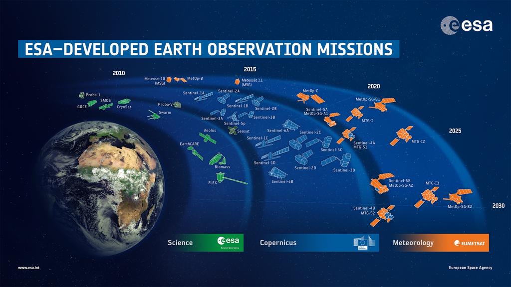
5


,")


6 A Strong European EO Service Portfolio Services with formal specifications, standards, validation Developed in collaboration and agreement with over 400 national user organisations More than 450 suppliers (typically small companies), with 7800 highly skilled staff Marine & Coastal Polar & Sea Ice Soil, Water & Urban Food Security Maritime Security Forest Monitoring Atmosphere Flood & Fire Risk Land Motion Humanitarian Aid
7 Earth Observation and the Global Agenda Sustainable Development UN SDGs Climate Action Paris Agreement Disaster Risk Reduction Sendai Framework Supporting Smart Decision-Making Monitoring & Understanding Providing Key Infrastructure

8 Supporting Sustainable Development


9 Earth Observation and the SDGs SDGs with major opportunities for EO data Earth Observation potential contribution to the SDG Targets and Indicators Analysis performed by the GEO EO4SDGs initiative


10 ESA Collaboration with IFIs in EO Since 2008, 65 small-scale demonstrations of EObased environmental information in support of multilateral bank development projects Responding to specific geospatial information needs MoUs and secondments in place with the World Bank and Asian Development Bank


11 A Dedicated Programme of Work: EO4SD EO4SD Earth Observation for Sustainable Development An ESA initiative for wide-scale exploitation of satellite data in support of international development Engaging various IFIs and their client states, and flagship global/regional programmes Key questions: What EO-based information is most needed? How can it be used in international development activities and working practices? What benefits does this information deliver to stakeholders (IFIs and their client states)? Do the benefits justify the costs? How can EO-based information be established on a long-term, sustainable basis? Currently running ( ): More thematic areas about to start or in preparation.

12 The ESA EO4SD-Urban Project


13 EO4SD-Urban


14 EO Products for Urban Development Green Areas/Networks Extent, Imperviousness and Change Building Footprint Population Density Waste Sites Baseline Products Urban and Peri-Urban Land Use / Land Cover Detailed Change Transport Infrastructure Informal Settlements Flood Risk Landslide Risk Terrain Motion

15 EO4SD-Urban: Geographic Spread IADB WBG ADB GEF GPSC Approx 40 cities distributed globally Including mega-cities and small to medium sized cities Covering a multitude of urban planning and development issues

16 EO4SD-Urban: Phase 1 ( ) Achievements: all cities received products Eight GPSC cities received urban extent and imperviousness products for 2015 meanwhile, these are ready for all GPSC cities! DLR now working on an urban extent temporal evolution product!


17 Examples of Input Imagery VHR example: WorldView m resolution normally available a few times per year commercial HR example: Sentinel-2 10 m resolution available every 5 days free and open


18 Example: Land Use/Land Cover 2010 Arusha, Tanzania


19 Example: Land Use/Land Cover 2015 Arusha, Tanzania


20 Example: Land Use/Land Cover Change Arusha, Tanzania Residential densification is more dominant in peri-urban zone Residential extension is more dominant in core urban zone

21 Example: Transport Network Arusha, Tanzania


22 Example: Urban Green Areas Dodoma, Tanzania Not an urban green area Permanent urban green area Loss of urban green area New urban green area
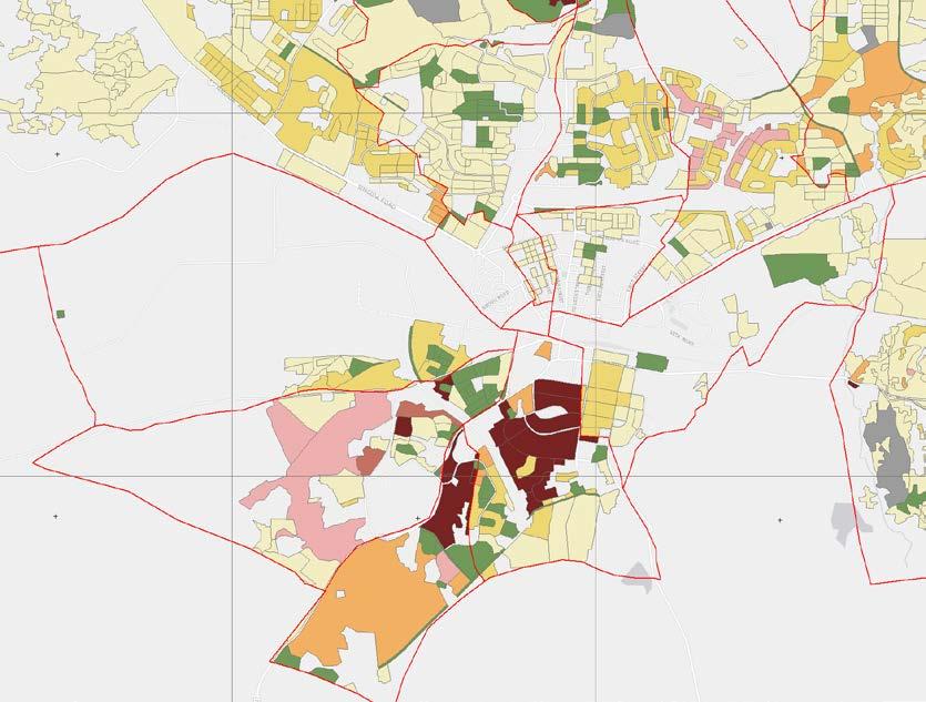
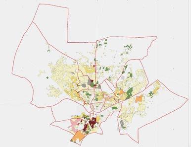
23 Example: Population Distribution Dodoma, Tanzania
 in the city centre and Sentinel-2 (10 m resolution) for periurban areas Delineation of informal")
24 Example: Informal Settlements Land Use and Land Cover (February March 2017), based on Pléiades (0.5 m resolution) in the city centre and Sentinel-2 (10 m resolution) for periurban areas Delineation of informal settlements Kolkata, India


25 Example: Flood Risk Requires: precise Digital Terrain Model adequate EO archive data coverage Semarang, Indonesia


26 Example: Terrain and Infrastructure Motion Semarang, Indonesia

27 Example: Urban Extent Abidjan, Côte d'ivoire

28 Example: Urban Extent Abidjan, Côte d'ivoire 2015

29 Example: Degree of Imperviousness
 to improve")
30 EO4SD-Urban: Value of the EO Products Product generation is based on: Verified user requirements Harmonised and standardised state-of-the-art methodologies Comprehensive and transparent documentation Application of statistically sound accuracy assessment Stringent Quality Control to ensure: transparency repeatability completeness validity User feedback needed (and some already given) to improve the services Geospatial products can be used to monitor SDG 11 Indicators


31 EO4SD-Urban: Outlook to Phase 2 ( ) Processing of geo-spatial products for additional urban projects in the different geographical regions will continue Stepping up the support to GPSC! Emphasis will be put on spatial analytics for urban planning Stakeholder feedback at the end of the project will provide the overall utility for urban planning This should support mainstreaming EO into urban development programmes
 EO Clinic: new 24-month activity starting in Q4 2018 to: fill")
32 New Activity in 2018: EO Clinic ESA s present collaboration with the MDBs is of a longer-term and larger-scale character, responding to flagship activities, like GPSC Ad-hoc requests in many, short-term and speculative requests for EO support coming from Banks and their client countries in many thematic areas (including urban) EO Clinic: new 24-month activity starting in Q to: fill the gap to address the above enquiries raise interest in EO further across banks, with new bank projects with no or very little previous contact with satellite-based EO Through the EO Clinic, development projects will be able to get help with their geospatial information problems ESA will fund small work orders with a pool of pre-qualified European EO service providers to investigate/demonstrate the use of EO towards solving the issue Work orders will be small-scale and of exploratory nature, not replacing largerscale procurement of commercial EO services Regional development banks (e.g. AfDB, DBSA) and new GPSC cities welcome!


33 Our Special GPSC African Workshop Posters! Abidjan Print-ready: 195 MB: Imperviousness Print-ready resolution, 280 MB: Low resolution, 5 MB: Johannesburg Print-ready: 139 MB: Dakar Print-ready: 244 MB: All three at low resolution, 20 MB:

34 Thank
Earth Observation for Sustainable Development to Support Land Use Planning in Urban Areas
 Background Image Source bbc.co.uk Human Planet 2011 BBC Earth Observation for Sustainable Development to Support Land Use Planning in Urban Areas Thomas Häusler, Sharon Gomez, Fabian Enssle GAF AG Land
Potential of Earth Observation to address global challenges of cities
 Potential of Earth Observation to address global challenges of cities Copernicus for Future cities workshop, 9 November 2018, Brussels Session III: cities challenges, user needs and innovation paths Marc
Earth Observation and Renewable Energy
 ESMAP Knowledge Exchange Forum 2013 November 21 The Hague, Netherlands Earth Observation and Renewable Energy Zoltan Bartalis Earth Observation Exploitation Engineer Science, Applications and Future Technologies
Towards best practices for using satellite Earth Observation in mining and extractives
 Towards best practices for using satellite Earth Observation in mining and extractives EU-Latin America Mining & Exploration Convention and Trade Show METS 2018 11 April 2018 Madrid Marriott Auditorium
EuroGEOSS Protected Areas Pilot
 EuroGEOSS Protected Areas Pilot Max Craglia European Commission Joint Research Centre Part 1: the present MyNatura2000 Mobile app. Awareness raising & volunteered data collection. Natura2000 covers 18%
Copernicus Today and Tomorrow GEO Week Group on Earth Observation Geneva, 16 January 2014 The Copernicus Space Infrastructure
 Copernicus Today and Tomorrow GEO Week Group on Earth Observation Geneva, 16 January 2014 The Copernicus Space Infrastructure Thomas Beer, Policy Coordinator, Copernicus Space Office, ESA-ESRIN, Frascati
Geographic Information Infrastructure and Policy Framework for Sustainable Mountain Development in the Hindu Kush-Himalayas
 Geo SMART ASIA 2017 22-24 August, Kualalampur Geographic Information Infrastructure and Policy Framework for Sustainable Mountain Development in the Hindu Kush-Himalayas Basanta Shrestha, Director Strategic
Earth Observations as a Tool To Achieve Sustainable Development Goals
 The image part with relationship ID rid3 was not found in the file. 16/10/2017 Earth Observations as a Tool To Achieve Sustainable Development Goals LI Jing, China GEO On behalf of the Group on Earth Observations
sentinel-2 COLOUR VISION FOR COPERNICUS
 sentinel-2 COLOUR VISION FOR COPERNICUS SATELLITES TO SERVE By providing a set of key information services for a wide range of practical applications, Europe s Copernicus programme is providing a step
Space Application in Support of Land Management for SDG Implementation
 Space Application in Support of Land Management for SDG Implementation Regional Expert Workshop on Land Accounting for SDG Monitoring and Reporting 26 September 2017 Space Application Section Information
Economic and Social Council
 United Nations Economic and Social Council Distr.: General 2 July 2012 E/C.20/2012/10/Add.1 Original: English Committee of Experts on Global Geospatial Information Management Second session New York, 13-15
Georeferencing and Satellite Image Support: Lessons learned, Challenges and Opportunities
 Georeferencing and Satellite Image Support: Lessons learned, Challenges and Opportunities Shirish Ravan shirish.ravan@unoosa.org UN-SPIDER United Nations Office for Outer Space Affairs (UNOOSA) UN-SPIDER
RESAP Progress Report
 RESAP Progress Report December 2016 to October 2017 Presentation to the Twenty-first session of the Intergovernmental Consultative Committee on the Regional Space Applications Programme for Sustainable
Dr Ozlem Adiyaman Earth Sciences and Geo-hazards Risk Reduction Section Division of Ecological and Earth Sciences ( ) NATURAL SCIENCES
 NATURAL SCIENCES") Earth Sciences and Geo-hazards Risk Reduction Section Earth observation with COPERNICUS to : protect, monitor, document, present and share our common heritage, our cultural and natural UNESCO World Heritage
Earth Sciences and Geo-hazards Risk Reduction Section Earth observation with COPERNICUS to : protect, monitor, document, present and share our common heritage, our cultural and natural UNESCO World Heritage
EO Information Services in support of Satellite Tools for Building Flood Defence Systems in Guyana
 EO Information Services in support of Satellite Tools for Building Flood Defence Systems in Guyana F. N. Koudogbo and A. Arnaud Altamira Information J. Leen, Eurosense World Bank HQ, Washington DC Date
Norwegian spatial data infrastructure supporting disaster risk management Norwegian Mapping Authority
 Norwegian spatial data infrastructure supporting disaster risk management Norwegian Mapping Authority Arvid Lillethun, Norwegian Mapping Authority Land and Poverty 2018 Conference, World Bank 19.-23. March
Working Group on Geospatial Information
 GEO-XIV Plenary Summary Working Group on Geospatial Information 4 th Meeting Lawrence Friedl Argyro Kavvada Group on Earth Observations NASA Earth Science Dec. 6-8, 2017 An intergovernmental organization
Emergency Management Service (EMS) mapping
 mapping") GMES Emergency Management Service (EMS) mapping Frédéric BASTIDE GMES unit, European Commission UN-SPIDER Expert Meeting: "Crowdsource Mapping for Disaster Risk Management and Emergency Response" 3-5 December,
GMES Emergency Management Service (EMS) mapping Frédéric BASTIDE GMES unit, European Commission UN-SPIDER Expert Meeting: "Crowdsource Mapping for Disaster Risk Management and Emergency Response" 3-5 December,
FINDINGS OF THE ARCTIC METEOROLOGY SUMMIT
 FINDINGS OF THE ARCTIC METEOROLOGY SUMMIT 2018 WWW.FMI.FI CHAIR S SUMMARY: 1 2 3 We need to be curious to explore the known unknowns. Meteorology is an elemental part of international collaboration in
THE ROLE OF GEOSPATIAL AT THE WORLD BANK
 THE ROLE OF GEOSPATIAL AT THE WORLD BANK INSPIRE Conference Barcelona, Spain September 26, 2016 Kathrine Kelm Senior Land Administration Specialist Global Land and Geospatial Unit The World Bank Group
The Global Statistical Geospatial Framework and the Global Fundamental Geospatial Themes
 The Global Statistical Geospatial Framework and the Global Fundamental Geospatial Themes Sub-regional workshop on integration of administrative data, big data and geospatial information for the compilation
Copernicus Overview and Emergency Management Service
 Copernicus Overview and Emergency Management Service Frédéric BASTIDE European Commission Open informal session of the United Nations Inter-Agency Meeting on Outer Space Activities 12 March 2013, Geneva
KUNMING FORUM ON UNITED NATIONS GLOBAL GEOSPATIAL INFORMATION MANAGEMENT CITIES OF THE FUTURE: SMART, RESILIENT
 KUNMING FORUM ON UNITED NATIONS GLOBAL GEOSPATIAL INFORMATION MANAGEMENT CITIES OF THE FUTURE: SMART, RESILIENT and SUSTAINABLE Yunnan Zhenzhuang Guest House, Kunming, China 10 12 May 2017 BACKGROUND CONCEPT
Towards eenvironment Prague, March GMES Space Component. Josef Aschbacher Head, ESA GMES Space Office
 Towards eenvironment Prague, 25-27 March 2009 GMES Space Component Josef Aschbacher Head, ESA GMES Space Office Prague from Space Segment 2 05 Nov 2003 CNES 2003 GISAT 2007 ESA GSELAND GMES is an EU led
Challenges and Successes in Sharing Geospatial Data in Africa
 Challenges and Successes in Sharing Geospatial Data in Africa 2018 GeoNode Summit Torino, Italy March 26-28, 2018 Bernard Justus Muhwezi Manager, Geo-Information Services Uganda Bureau of Statistics, Kampala,
Meteorological instruments and observations methods: a key component of the Global Earth Observing System of Systems (GEOSS)
") GLOBAL OBSERVING SYSTEMS Instruments and Methods of Observation Programme Meteorological instruments and observations methods: a key component of the Global Earth Observing System of Systems (GEOSS) Dr.
GLOBAL OBSERVING SYSTEMS Instruments and Methods of Observation Programme Meteorological instruments and observations methods: a key component of the Global Earth Observing System of Systems (GEOSS) Dr.
Geospatial Information and Services for Disasters (GIS4D)
") Geospatial Information and Services for Disasters (GIS4D) 31 July 2017 Tae Hyung KIM ICT and Disaster Risk Reduction Division (IDD) UNESCAP 1 About ESCAP Who is ESCAP? United Nations Economic and Social
Geospatial Information and Services for Disasters (GIS4D) 31 July 2017 Tae Hyung KIM ICT and Disaster Risk Reduction Division (IDD) UNESCAP 1 About ESCAP Who is ESCAP? United Nations Economic and Social
Space Applications for Disaster Risk Reduction and Sustainable Development
 Space Applications for Disaster Risk Reduction and Sustainable Development Space Applications Section (SAS) ICT and Disaster Risk Reduction Division (IDD) UNESCAP Contents I. RESAP Activities 2016-2017
GMES Service for Geospatial Reference Data Access (RDA) Covering Areas Outside Europe
 Covering Areas Outside Europe") INSPIRE Conference 2011 Edinburgh 27 June - 1 July GMES Service for Geospatial Reference Data Access (RDA) Covering Areas Outside Europe Andrea Ajmar, Simone Balbo, Piero Boccardo, Simone Dalmasso, Anna
INSPIRE Conference 2011 Edinburgh 27 June - 1 July GMES Service for Geospatial Reference Data Access (RDA) Covering Areas Outside Europe Andrea Ajmar, Simone Balbo, Piero Boccardo, Simone Dalmasso, Anna
European Space Agency
 Guidelines - Guidelines how/when to interact during the WebEx session: - Due to the number of attendees, please keep always your webcam and microphone switched-off - You can use anytime the chat to all
Applied Geoscience and Technology Division SOPAC. Joy Papao, Risk Information Systems Officer
 Joy Papao, Risk Information Systems Officer Secretariat of the Pacific Community SPC 22 Pacific Island States Head office in Noumea, New Caledonia 2 Regional offices (Pohnpei and Honiara) 600 staff 9 Technical
Earth Observation and GEOSS in Horizon Copernicus for Raw Material Workshop 5 th September 2016
 Earth Observation and GEOSS in Horizon 2020 Copernicus for Raw Material Workshop 5 th September 2016 Gilles OLLIER Head of Sector -Earth observation Directorate Environment Unit I.4 Climate Actions and
The Integrated Ge spatial Information Framework to the strengthening of NSDI, Mongolia
 Young Geospatial Professionals Summit 21 NOV 2018 The Integrated Ge spatial Information Framework to the strengthening of NSDI, Mongolia BAYARMAA ENKHTUR Geospatial information and technology department
Space for Sustainable Development
 Space for Sustainable Development ESA s contribution to the Where, What, and How of Data Dr. Christoph Aubrecht Directorate of Earth Observation Programmes Science, Applications and Future Technologies
SUPPORTS SUSTAINABLE GROWTH
 DDSS BBUUN NDDLLEE G E O S P AT I A L G O V E R N A N C E P A C K A G E SUPPORTS SUSTAINABLE GROWTH www.digitalglobe.com BRISBANE, AUSTRALIA WORLDVIEW-3 30 CM International Civil Government Programs US
Building Institutional Capacity for Multi-Hazard Early Warning in Asia and the Pacific Subtitle
 Building Institutional Capacity for Multi-Hazard Early Warning in Asia and the Pacific Subtitle Title Keran Wang Chief, Space Applications Section ICT and Disaster Risk Reduction Division 22 May 2018 Pillar
Building Institutional Capacity for Multi-Hazard Early Warning in Pacific Countries Subtitle
 Building Institutional Capacity for Multi-Hazard Early Warning in Pacific Countries Subtitle Title Keran Wang Chief, Space Applications Section ICT and Disaster Risk Reduction Division 30 March 2018 Slide
Introduction of the Asia-Oceania Global Earth Observation System of Systems (AOGEOSS) GEO Initiative(GI-22 )
 GEO Initiative(GI-22 )") Introduction of the Asia-Oceania Global Earth Observation System of Systems (AOGEOSS) GEO Initiative(GI-22 ) Prof. Xiang ZHOU Institute of Remote Sensing and Digital Earth, CAS 11 May 2017 Kunming, China
Introduction of the Asia-Oceania Global Earth Observation System of Systems (AOGEOSS) GEO Initiative(GI-22 ) Prof. Xiang ZHOU Institute of Remote Sensing and Digital Earth, CAS 11 May 2017 Kunming, China
RCOF Review [Regional Climate Outlook Forum for the Gulf of Guinea region of Africa - PRESAGG] Status Report
![RCOF Review [Regional Climate Outlook Forum for the Gulf of Guinea region of Africa - PRESAGG] Status Report](/thumbs/78/77466191.jpg "RCOF Review [Regional Climate Outlook Forum for the Gulf of Guinea region of Africa - PRESAGG] Status Report") RCOF Review 2017 [Regional Climate Outlook Forum for the Gulf of Guinea region of Africa - PRESAGG] Status Report Specific Climate features of concerned region This region typically covers the area below
RCOF Review 2017 [Regional Climate Outlook Forum for the Gulf of Guinea region of Africa - PRESAGG] Status Report Specific Climate features of concerned region This region typically covers the area below
Copernicus Overview. Major Emergency Management Conference Athlone 2017
 Copernicus Overview Major Emergency Management Conference Athlone 2017 Copernicus is a European programme implemented by the European Commission. The services address six thematic areas: land, marine,
Geological information for Europe : Towards a pan-european Geological Data Infrastructure
 Geological information for Europe : Towards a pan-european Geological Data Infrastructure Integrating geoscientific information for EU competitiveness Co-funded by the European Union European societal
Observation (EO) & Geomatics in Canada
 & Geomatics in Canada") Innovating to Increase the Impact of Earth Observation (EO) & Geomatics in Canada Natural Resources Canada February 25, 2014 Prashant Shukle, Director General Canada Centre for Mapping and Earth Observation
Innovating to Increase the Impact of Earth Observation (EO) & Geomatics in Canada Natural Resources Canada February 25, 2014 Prashant Shukle, Director General Canada Centre for Mapping and Earth Observation
SDG s and the role of Earth Observation
 SDG s and the role of Earth Observation Christian Heipke IPI - Institute for Photogrammetry and GeoInformation Leibniz Universität Hannover Germany Secretary General, ISPRS 1. No Poverty 2. Zero Hunger
Spanish national plan for land observation: new collaborative production system in Europe
 ADVANCE UNEDITED VERSION UNITED NATIONS E/CONF.103/5/Add.1 Economic and Social Affairs 9 July 2013 Tenth United Nations Regional Cartographic Conference for the Americas New York, 19-23, August 2013 Item
The Role of EO Consultants and SMEs within GMES. Geoff Smith
 The Role of EO Consultants and SMEs within GMES Geoff Smith Enable clients to deliver useful, accurate and reliable environmental information from EO. Positioned to bridge the gaps between technology development,
Roadmap to interoperability of geoinformation
 Roadmap to interoperability of geoinformation and services in Europe Paul Smits, Alessandro Annoni European Commission Joint Research Centre Institute for Environment and Sustainability paul.smits@jrc.it
Earth Observation for development. Geoff Sawyer, EARSC Secretary General 12 April 201, WB, Washington,
 Earth Observation for development Geoff Sawyer, EARSC Secretary General 12 April 201, WB, Washington, what is EARSC? There is no sustainable developmeny without adequate information about the state of
2018/1 The integration of statistical and geospatial information. The Regional Committee of UN-GGIM: Americas:
 The following are the conclusions and recommendations of the Regional Committee of the United Nations on Global Geospatial Information Management for the Americas, during its Fifth Session, Thursday 8
Plan4all (econtentplus project)
") Plan4all (econtentplus project) Karel CHARVAT 1, Tomáš MILDORF 2 1 Help service remote sensing, Ltd., Černoleská 1600, 256 01 Benešov u Prahy, Czech Republic charvat@bnhelp.cz 2 Department of Mathematics
Plan4all (econtentplus project) Karel CHARVAT 1, Tomáš MILDORF 2 1 Help service remote sensing, Ltd., Černoleská 1600, 256 01 Benešov u Prahy, Czech Republic charvat@bnhelp.cz 2 Department of Mathematics
COPERNICUS SPACE DATA OFFER FOR PUBLIC AUTHORITIES DISTRIBUTED BY ESA
 COPERNICUS SPACE DATA OFFER FOR PUBLIC AUTHORITIES DISTRIBUTED BY ESA The Copernicus Space Component Data Access (CSC-DA) service - financed by the EU and operated by ESA - grants National Public Authorities
Land Monitoring Core Service Implementation Group (LMCS IG) - Results and Outlook
 - Results and Outlook") Land Monitoring Core Service Implementation Group (LMCS IG) - Results and Outlook Pr. Dietmar Grünreich, President of BKG, Germany Chairman of the GMES LMCS IG Outline 1 Introduction 2 Preparatory Projects
Land Monitoring Core Service Implementation Group (LMCS IG) - Results and Outlook Pr. Dietmar Grünreich, President of BKG, Germany Chairman of the GMES LMCS IG Outline 1 Introduction 2 Preparatory Projects
Manual of Digital Earth
 V8.0 March 27, 2018 International Society for Digital Earth Manual of Digital Earth (Tentative Title) OUTLINE Foreword Chapter 1 Understanding Digital Earth 1.1 Origins and Precursors of Digital Earth
Geospatial Information and Sustainable Development (Rio+20) A Belgian perspective
 A Belgian perspective") Geospatial Information and Sustainable Development (Rio+20) A Belgian perspective In the resolution adopted by the General Assembly, The future we want World leaders acknowledged the need to further mainstream
Geospatial Information and Sustainable Development (Rio+20) A Belgian perspective In the resolution adopted by the General Assembly, The future we want World leaders acknowledged the need to further mainstream
Global Monitoring for Environment and Security (GMES)
") Global Monitoring for Environment and Security (GMES) Satellite Earth Observation for the Emergency Services Dr Nick Veck Presentation to the G-STEP Launch Univ. of Leicester 19 th June 2009 Contents of
Global Monitoring for Environment and Security (GMES) Satellite Earth Observation for the Emergency Services Dr Nick Veck Presentation to the G-STEP Launch Univ. of Leicester 19 th June 2009 Contents of
Geospatial Technologies for Resources Planning & Management
 Geospatial Technologies for Resources Planning & Management Lal Samarakoon, PhD Director, Geoinformatics Center Asian Institute of Technology, Thailand Content Geoinformatics for SDG Information Integration
Sharthi Laldaparsad Statistics South Africa, Policy Research & Analysis. Sub-regional workshop on integration of administrative data,
 Sub-regional workshop on integration of administrative data, big data and geospatial information for the compilation of SDG indicators and International Workshop on Global Fundamental Geospatial Data Themes
Geographic information strategy
 Department for Environment, Food and Rural Affairs Geographic information strategy Methodology JULY 2011 2 Geographic information strategy Methodology This document provides a detailed description of the
Economic and Social Council
 United Nations Economic and Social Council Distr.: General 18 July 2016 Original: English Committee of Experts on Global Geospatial Information Management Sixth session New York, 3-5 August 2016 Item 2
Geospatial workflows and potential applications to the Sustainable Development Goals of countries in West Asia
 Geospatial workflows and potential applications to the Sustainable Development Goals of countries in West Asia Ameer Abdulla, PhD Senior Advisor, European Topic Center for Spatial Analysis, Spain Associate
Realizing benefits of Spatial Data Infrastructure A user s perspective from Environment Agency - Abu Dhabi
 Realizing benefits of Spatial Data Infrastructure A user s perspective from Environment Agency - Abu Dhabi Anil Kumar Director, Environment Information Management 26 April 2012 Geospatial World Forum,
UN GGIM and National SDI Strategy
 MSDI Open Forum on 26 th January 2016 Contributing to the successful delivery of MSDI UN GGIM and National SDI Strategy Hiroshi Murakami Deputy Administrator Geospatial Information Authority of Japan Geospatial
GUIDELINE: SD/GN/03 Last Updated on February 19, Application of Policy on Agency Minimum Standards on Environmental and Social Safeguards
 GUIDELINE: SD/GN/03 Last Updated on February 19, 2015 Application of Policy on Agency Minimum Standards on Environmental and Social Safeguards Summary: This Guideline explains how the GEF will assess the
Spatially enabling e-government through geo-services
 Spatially enabling e-government through geo-services Mauro Salvemini EUROGI PRESIDENT Professor at Sapienza Università di Roma (IT) 1 About the presentation Few information about Eurogi ; Some essential
EU collaborations with NASA LCLUC Program & Current Priorities
 & Current Priorities ioannis Manakos, Dr. Centre for Research and Technology Hellas Information Technologies Institute Visual Analytics, Virtual & Augmented Reality Laboratory European Association of Remote
EO4SEE - THE PATHFINDER OF OPERATIONAL SATELLITE MONITORING FOR THE REGION OF THE BLACK SEA AND CENTRAL EUROPE
 EO4SEE: Pathfinder assessment for regional high volume data access, processing and information service delivery platforms - South East Region EO4SEE - THE PATHFINDER OF OPERATIONAL SATELLITE MONITORING
Spatial Analysis of Natural Hazard and Climate Change Risks in Peri-Urban Expansion Areas of Dakar, Senegal
 1 Spatial Analysis of Natural Hazard and Climate Change Risks in Peri-Urban Expansion Areas of Dakar, Senegal URBAN WEEK 2009 BBL Preston Lounge Thursday, March 12, 2009 Christian Hoffmann GeoVille group
SAWIDRA Southern Africa
 SAWIDRA Southern Africa Presenter: Thembani Moitlhobogi Assistant Database and IT Expert SADC Climate Services Centre 13 th EUMETSAT Forum in Africa 24-28 September 2018, Abidjan, Cote d Ivoire Context
Plenary Session 2, part 2 A European shared information system
 3 rd GMES Forum 5 6 June 2003 Athens Plenary Session 2, part 2 A European shared information system Gordon McInnes Deputy Director European Environment Agency 1 I keep six honest serving men. They taught
Applying Hazard Maps to Urban Planning
 Applying Hazard Maps to Urban Planning September 10th, 2014 SAKAI Yuko Disaster Management Expert JICA Study Team for the Metro Cebu Roadmap Study on the Sustainable Urban Development 1 Contents 1. Outline
Prof Chryssy Potsiou, FIG President
 THE VALUE OF GEOSPATIAL DATA AND ROLE OF SURVEYORS IN SUSTAINABLE DEVELOPMENT Prof Chryssy Potsiou, FIG President National Technical University of Athens School of Rural and Surveying Engineering, Greece
KENYA NATIONAL BUREAU OF STATISTICS Workshop on
 KENYA NATIONAL BUREAU OF STATISTICS Workshop on Capacity Building in Environment Statistics: the Framework for the Development of Environment Statistics (FDES 2013) Coordination with Sector Ministries
Measuring Disaster Risk for Urban areas in Asia-Pacific
 Measuring Disaster Risk for Urban areas in Asia-Pacific Acknowledgement: Trevor Clifford, Intl Consultant 1 SDG 11 Make cities and human settlements inclusive, safe, resilient and sustainable 11.1: By
International Conference Analysis and Management of Changing Risks for Natural Hazards November 2014 l Padua, Italy
 Abstract Code: B01 Assets mapping products in support of preparedness and prevention measures (examples from Germany, Italy and France) Marc Mueller, Thierry Fourty, Mehdi Lefeuvre Airbus Defence and Space,
The ESA Earth observation programmes overview and outlook
 The ESA Earth observation programmes overview and outlook Dr. Volker Liebig Director, ESA EO Programmes ILA 2008, Berlin ENVISAT mission: 6 years! Bam earthquake Tectonic uplift (Andaman) Arctic 2007 First
EO Information Services. Assessing Vulnerability in the metropolitan area of Rio de Janeiro (Floods & Landslides) Project
 Project") EO Information Services in support of Assessing Vulnerability in the metropolitan area of Rio de Janeiro (Floods & Landslides) Project Ricardo Armas, Critical Software SA Haris Kontoes, ISARS NOA World
EO Information Services in support of Assessing Vulnerability in the metropolitan area of Rio de Janeiro (Floods & Landslides) Project Ricardo Armas, Critical Software SA Haris Kontoes, ISARS NOA World
Implementing the Sustainable Development Goals: The Role of Geospatial Technology and Innovation
 Fifth High Level Forum on UN Global Geospatial Information Management Implementing the Sustainable Development Goals: The Role of Geospatial Technology and Innovation 28-30 November 2017 Sheraton Maria
ZRCSAZU. Remote sensing and Earth observation data at ZRC SAZU. dr. Tatjana Veljanovski Atrij ZRC Ljubljana
 ZRCSAZU Remote sensing and Earth observation data at ZRC SAZU dr. Tatjana Veljanovski 2016-06-08 Atrij ZRC Ljubljana Remote Sensing Department Remote Sensing Department 20 years of experience application,
Geospatial framework for monitoring SDGs/Sendai targets By Shimonti Paul Sr. Assistant Editor Geospatial Media & Communications
 Geospatial framework for monitoring SDGs/Sendai targets By Shimonti Paul Sr. Assistant Editor Geospatial Media & Communications Outline 1. Introduction to Geospatial Media and Communications 2. Geospatial
2 nd Semester. Core Courses. C 2.1 City and Metropolitan Planning. Module 1: Urban Structure and Growth Implications
 2 nd Semester Core Courses C 2.1 City and Metropolitan Planning Module 1: Urban Structure and Growth Implications Growth of cities; cities as engine of growth; urban sprawl; land value, economic attributes
COEX CONVENTION AND EXHIBITION CENTRE SEOUL REPUBLIC OF KOREA
 REPUBLIC OF NAMIBIA SPEECH BY ALPHEUS G.!NARUSEB, (MP) MINISTER OF LANDS AND RESETTLEMENT IN THE REPUBLIC OF NAMIBIA AT THE HIGH LEVEL GLOBAL GEOSPATIAL INFORMATION MANAGEMENT FORUM ORGANISED BY THE UNITED
World Meteorological Organization
 World Meteorological Organization Opportunities and Challenges for Development of Weather-based Insurance and Derivatives Markets in Developing Countries By Maryam Golnaraghi, Ph.D. Head of WMO Disaster
The GMES/MyOcean Marine Service and its applications
 The GMES/MyOcean Marine Service and its applications P.Y. Le Traon (Ifremer) P. Bahurel (Mercator Ocean) First BreTel Workshop May 31st, 2012 - St Malo Outline The GMES Marine Service and MyOcean What
13 th EUMETSAT User Forum in Africa
 13 th EUMETSAT User Forum in Africa GMES & Africa implementation in Western Africa Dogbeda M.Y. Azumah Regional Marine Centre University of Ghana Pictures zone UG GMES Presentation Layout UG G Project
Mapping Water Resources and Reservoirs for Climate Resilience in Zambezi River Basin
 Mapping Water Resources and Reservoirs for Climate Resilience in Zambezi River Basin Corné van der Sande, NEO BV Senior Advisor Earth Observation Services for Monitoring Drought and Water Resources in
ISTAMBUL April 22, pm
 Global Urban Data Initiative ISTAMBUL April 22, 11-12.30 pm Tokyo Ho Chi Minh Moscow Global Urban Data Initiative Global Urban and DRM Unit LEARN ABOUT: Data Access through PUMA Portal and ESA Urban Thematic
PRE DICT. PREDICT Project. Prevent and Respond to Epidemics and Demonstrate Information and Communication Technologies.
 PRE DICT PREDICT Project Prevent and Respond to Epidemics and Demonstrate Information and Communication Technologies IAC Conference October 5 th 2011 DSV Context About 75 % of the new diseases having affected
A proposal for building an infrastructure for European geospatial statistics. Marie Haldorson, Statistics Sweden Ekkehard Petri, Eurostat
 A proposal for building an infrastructure for European geospatial statistics Marie Haldorson, Statistics Sweden Ekkehard Petri, Eurostat What is geospatial statistics? The location, extent or spatial relations
Historical Assessment of Spatial Growth of Built-ups and Metropolitan areas of Delhi and Mumbai in India and Dhaka in Bangladesh
 Historical Assessment of Spatial Growth of Built-ups and Metropolitan areas of Delhi and Mumbai in India and Dhaka in Bangladesh Tomas Soukup, GISAT World Bank HQ, Washington DC Date : 12 April 2011 Introduction
International Guidelines on Access to Basic Services for All
 International Guidelines on Access to Basic Services for All Presentation and initials lessons from implementation Accessibility to services in regions and cities : measures and policies, OECD 18 June
Weather Climate Science to Service Partnership South Africa
 PROJECTS UNDERWAY Title of the Weather Climate Science to Service Partnership South Africa Together, building on an existing strong partnership, South African Weather Service and the Met Office will build
C o p e r n i c u s a n d W I G O S
 C o p e r n i c u s a n d W I G O S Jean-Noël Thépaut & Mark Dowell 24 October 2017 GEO XIV, Washington DC, 23-28 October 2017 T h e C o p e r n i c u s P r o g r a m m e Copernicus is the European Union
Role of National Legal and Policy Frameworks on Geospatial Information
 Role of National Legal and Policy Frameworks on Geospatial Information International Workshop on Legal and Policy Frameworks for Geospatial Information Nuku alofa, Kingdom of Tonga 10-13 April Objective
Meteorological Cooperation in the Arctic. Perspectives from Finland
 Meteorological Cooperation in the Arctic Perspectives from Finland Improving public safety, better data coverage, enhancing arctic climate science VAWS Webinar Series Fairbanks, Alaska May 10th 2017 Finland
UN-GGIM: Strengthening Geospatial Capability
 Fifth Plenary Meeting of UN-GGIM: Europe Brussels, 6-7 June 2018 UN-GGIM: Strengthening Geospatial Capability Walking the talk to leave no one behind Greg Scott, UN-GGIM Secretariat Environmental Statistics
National Satellite Data Centre and Finnish Sentinel Collaborative Ground Segment. Jyri Heilimo Finnish Meteorological Instute
 National Satellite Data Centre and Finnish Sentinel Collaborative Ground Segment Jyri Heilimo Finnish Meteorological Instute Sodankylä National Satellite Data Centre National satellite data centre providing
The International Charter Space and Major Disasters is further strengthening its contribution to disaster management worldwide.
 28 September 2012 Issue 3 The International Charter Space and Major Disasters is further strengthening its contribution to disaster management worldwide. Building on a decade of success in making satellite
Land Use in the context of sustainable, smart and inclusive growth
 Land Use in the context of sustainable, smart and inclusive growth François Salgé Ministry of sustainable development France facilitator EUROGI vice president AFIGéO board member 1 Introduction e-content+
Space research. Horizon Work Programme. "Countdown to Horizon 2020 Space" Earth Observation topics. Brussels, 12 December 2013
 Space research Horizon 2020 - Work Programme "Countdown to Horizon 2020 Space" Earth Observation topics Brussels, 12 December 2013 richard.gilmore@ec.europa.eu Table of contents FP/Copernicus - general
a national geological survey perspective François ROBIDA BRGM (French Geological Survey)
") a national geological survey perspective François ROBIDA BRGM (French Geological Survey) Pre-Conference Seminar on Socio-Economic Value of Geospatial for National and Regional Development 21 August 2017,
a national geological survey perspective François ROBIDA BRGM (French Geological Survey) Pre-Conference Seminar on Socio-Economic Value of Geospatial for National and Regional Development 21 August 2017,
A proposal for building an infrastructure for European geospatial statistics
 A proposal for building an infrastructure for European geospatial statistics Marie Haldorson, Statistics Sweden Ekkehard Petri, Eurostat What is geospatial statistics? The location, extent or spatial relations