Mud Volcanoes in the South Caspian Basin: Activity Inferred From ENVISAT ASAR Images
|
|
|
- Lee Scott
- 5 years ago
- Views:
Transcription

1 Mud Volcanoes in the South Caspian Basin: Activity Inferred From ENVISAT ASAR Images Martin Weinelt & Warner Brückmann Helmholtz Centre for Ocean Research Kiel 1


2 Mud Volcanoes in the South Caspian Basin MV Occurrence onshore More than 1100 worldwide - ~50% Caspian Sea Area M.Weinelt & W. Brückmann GEOMAR Kiel 2

3 On-shore GE M.Weinelt & W. Brückmann GEOMAR Kiel 3
 forced up to the surface M.Weinelt & W.")
4 Driving mechanism: - Sediment overpressure - High rates of accumulation - Tectonically induced compression - Relative vertical movement Resulting in: Water and gas (~80% methane) forced up to the surface M.Weinelt & W. Brückmann GEOMAR Kiel 4
 Example of a large anticlinal structure with an active mud volcano complex within a structurally controlled collapse depression and large recent")
5 Driving Mechanisms cntd. - Overpressure - Gaseous phase (methane) Example of a large anticlinal structure with an active mud volcano complex within a structurally controlled collapse depression and large recent flows (>9 km) and two generations of sidewall slumping, Nakhchivan anticline, western SCB. (modified from Corthay and Aliyev,2000) M.Weinelt & W. Brückmann GEOMAR Kiel 5
 M.Weinelt & W.")
6 Mud Volcanoes in the South Caspian Basin MV off-shore MV North Alex, Nile Delta off Egypt (J. Bialas, GEOMAR) M.Weinelt & W. Brückmann GEOMAR Kiel 6
7 Mud Volcanoes at the Sea Floor Gas flares from the seafloor North Alex (Nile Delta) M.Weinelt & W. Brückmann GEOMAR Kiel 7


8 Nice, so what hazards? - Ground instability and motion - Fluid and gas flow - Climatic impact (greenhouse gas) Source: Institute of Geology of the Azerbaijan Academy of Science M.Weinelt & W. Brückmann GEOMAR Kiel 8
 Basemap: Open")

9 Selected SAR Scenes (ENVISAT) Basemap: Open Street Map (CC by/sa) M.Weinelt & W. Brückmann GEOMAR Kiel 9
; (Smith-Rouch 2006 based on Berberian 1983) M.Weinelt & W. Brückmann GEOMAR Kiel10")
10 Mud Volcanoes in the South Caspian Basin Plate collision outline Outline of plate motion and direction (white arrows) and strike-slip faults (black half-arrows); (Smith-Rouch 2006 based on Berberian 1983) M.Weinelt & W. Brückmann GEOMAR Kiel10
 M.Weinelt & W.")
11 Mud Volcanoes in the South Caspian Basin Compressional Regime Caspian Area Mesozoic-Neogene plate reconstruction closure of Tethys ocean (Golonka, 2007) M.Weinelt & W. Brückmann GEOMAR Kiel 11
 M.Weinelt & W.")
12 Mud Volcanoes in the South Caspian Basin Huge Pile of Accretionary Sediments Depth to basement south of Aspheron ridge: > 20km (Green et al, 2009) M.Weinelt & W. Brückmann GEOMAR Kiel12


13 Spotting MV from long distance: 1: Physiographic hints The typical shape Narrow range DEM rendering SCB GRSG/OGEO Workshop 2011 Kiel M.Weinelt & W. Brückmann GEOMAR 13

 Contouring GRSG/OGEO Workshop 2011")
14 Spotting MV from Long Distance: DEM Analysis Raster Data Analysis: Aspect (Slope, Ruggedness,...) Contouring GRSG/OGEO Workshop 2011 Kiel M.Weinelt & W. Brückmann GEOMAR 14

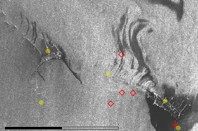
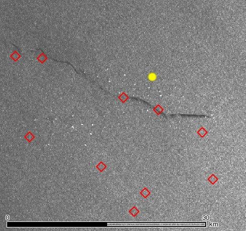
15 ~ 270 MV Suspects identified Circles: MV already mapped (Dadachev et al, 1995) Diamonds: Suspects derived from DEM GRSG/OGEO Workshop 2011 Kiel M.Weinelt & W. Brückmann GEOMAR 15


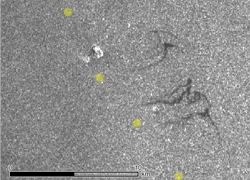
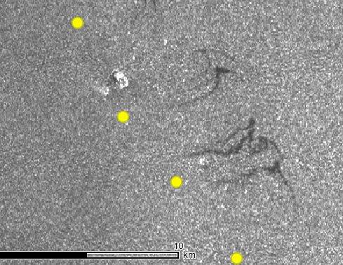
16 Spotting MV from long distance: 2: Natural Oil Slicks ESA / ENVISAT M.Weinelt & W. Brückmann GEOMAR Kiel16


17 Radar Scene Selection Weather information ESA Archive Selected scenes M.Weinelt & W. Brückmann GEOMAR Kiel17
 or spiral eddies (currents)")


18 Imaging Control: Wind Speed ENVISAT ASAR images south east off Baku showing the effect of different wind conditions on SAR imagery. Top left: with very slight or no wind large areas of very low backscatter occur (close to the coast) or spiral eddies (currents) overprint oil-slicks. Top right: the preferable wind speed window ambient backscatter is sufficiently intensive to clearly show oil slicks or patches in the vicinity of offshore oil-installations east of the Absheron peninsula. The switch from northwesterly to northerly wind directions is clear in the oil slick track. Bottom left: High wind regime. Oil slicks may get almost completely undetectable by intensified wave action or damping becomes ineffective in terms of the ASAR imagery. SAR Images: ESA M.Weinelt & W. Brückmann GEOMAR Kiel18
19 SAR Image: ESA Registration Date 0 8/29/2005 Wind Conditions NNW 7.2 m/s Weather Station Baku (dist. 60km) Image Patterns Preferable wind conditions result in high contrast imaging of oil slicks mostly due to pollution around oil installations. Westernmost streaks: potentially from seafloor seepage. M.Weinelt & W. Brückmann GEOMAR Kiel19
 Image Patterns Despite the low wind regime the imaging quality of the scene in terms of contrasting patterns is very good.")
20 SAR Image: ESA Registration Date Wind Conditions ENE 2.0 m/s Weather Station Turkmenbashi (dist. 45km) Image Patterns Despite the low wind regime the imaging quality of the scene in terms of contrasting patterns is very good. Low wind speed leads to large low backscatter areas off the cost Turkmenistan and associated spiral patterns. Straight west of Cheleken a ~27km long and ~150m to 250m wide slick is clearly detected. Bright pixels in the vicinity represent off-shore installations. M.Weinelt & W. Brückmann GEOMAR Kiel20
21 SAR Image: ESA Registration Date 0 8/29/2005 Wind Conditions NNW 7.2 m/s Weather Station Baku (dist. 60km) Image Patterns Preferable wind conditions result in high contrast imaging of oil slicks mostly due to pollution around oil installations. Westernmost streaks: potentially from seafloor seepage. M.Weinelt & W. Brückmann GEOMAR Kiel21
 Image Patterns Good contrast image. More than 25 dark streaks (natural oil slicks) roughly oriented according to the wind direction.")
22 SAR Image: ESA Registration Da te 0 9/17/2005 Wind Conditions N 6.2 m/s Weather Station Baku (dist. 200km) Image Patterns Good contrast image. More than 25 dark streaks (natural oil slicks) roughly oriented according to the wind direction. M.Weinelt & W. Brückmann GEOMAR Kiel22
 Image Patterns Low wind causes low backscatter close to the coast and for central parts of the area. Local front and eddy patterns dominate the image.")
23 SAR Image: ESA Registration Date 0 9/17/2005 Wind Conditions WNW 2.0 Weather Station Rasht (dist. 100km) Image Patterns Low wind causes low backscatter close to the coast and for central parts of the area. Local front and eddy patterns dominate the image. Dog leg -shaped streaks at the eastern part of the area display a typical oil slick shape. M.Weinelt & W. Brückmann GEOMAR Kiel23

24 SAR Image: ESA Registration Date 11 /26/2005 Wind Conditions S 6.0 Weather Station Baku (dist. 45km) Image Patterns Good contrast between ambient backscatter and oil covered surface areas. Dark patches very prominent around industry installations off-shore. 4 to 5 slicks of ~3km to 4km length at the southern edge of the scene obviously unrelated to oil production installations. M.Weinelt & W. Brückmann GEOMAR Kiel24
25 Indicative Patterns M.Weinelt & W. Brückmann GEOMAR Kiel25
26 Conclusions: Results presented here are from a 9 month pilot study Project initiated in November 2011 First field work in next year. GRSG/OGEO Workshop 2011 Kiel M.Weinelt & W. Brückmann GEOMAR 26


27 Sponsoring partners GRSG/OGEO Workshop 2011 Kiel M.Weinelt & W. Brückmann GEOMAR 27
Indonesian seas Numerical Assessment of the Coastal Environment (IndoNACE) Executive Summary
 Executive Summary") Indonesian seas Numerical Assessment of the Coastal Environment (IndoNACE) Executive Summary Study team members: Dr. Martin Gade, PD Dr. Thomas Pohlmann, Dr. Mutiara Putri Research Centres: Universität
Indonesian seas Numerical Assessment of the Coastal Environment (IndoNACE) Executive Summary Study team members: Dr. Martin Gade, PD Dr. Thomas Pohlmann, Dr. Mutiara Putri Research Centres: Universität
USU 1360 TECTONICS / PROCESSES
 USU 1360 TECTONICS / PROCESSES Observe the world map and each enlargement Pacific Northwest Tibet South America Japan 03.00.a1 South Atlantic Arabian Peninsula Observe features near the Pacific Northwest
TAKE HOME EXAM 8R - Geology
 Name Period Date TAKE HOME EXAM 8R - Geology PART 1 - Multiple Choice 1. A volcanic cone made up of alternating layers of lava and rock particles is a cone. a. cinder b. lava c. shield d. composite 2.
1 Executive summary. 2 Principles of SAT-OCEAN service
 S SCOPE OF WORK FOR ROUTING SERVICES 1 Executive summary SAT-OCEAN has developed an innovative routing service enabling for significant time and energy savings. This solution is going beyond traditional
Earth Science, (Tarbuck/Lutgens) Chapter 10: Mountain Building
 Chapter 10: Mountain Building") Earth Science, (Tarbuck/Lutgens) Chapter 10: Mountain Building 1) A(n) fault has little or no vertical movements of the two blocks. A) stick slip B) oblique slip C) strike slip D) dip slip 2) In a(n) fault,
Earth Science, (Tarbuck/Lutgens) Chapter 10: Mountain Building 1) A(n) fault has little or no vertical movements of the two blocks. A) stick slip B) oblique slip C) strike slip D) dip slip 2) In a(n) fault,
Spaceborne radar applications in Geology
 216 051 ESATM-17 December 2005 Spaceborne radar applications in Geology An introduction to imaging radar, and application examples of ERS SAR in Geology and Geomorphology European Spate Agency Agente spatiale
Copyright McGraw-Hill Education. All rights reserved. No reproduction or distribution without the prior written consent of McGraw-Hill Education
 Copyright McGraw-Hill Education. All rights reserved. No reproduction or distribution without the prior written consent of McGraw-Hill Education Tibetan Plateau and Himalaya -southern Asia 11.00.a VE 10X
Introduction to Acoustic Remote Sensing and Seafloor Mapping (AE4-E13) May 19, 2010
 May 19, 2010") Introduction to Acoustic Remote Sensing and Seafloor Mapping (AE4-E13) May 19, 2010 1 Delft Vermelding Institute onderdeel of Earth organisatie Observation and Space Systems Why Acoustic Remote Sensing?
Introduction to Acoustic Remote Sensing and Seafloor Mapping (AE4-E13) May 19, 2010 1 Delft Vermelding Institute onderdeel of Earth organisatie Observation and Space Systems Why Acoustic Remote Sensing?
Colombia s Offshore*
 PS A Seismic-Structural Interpretation, on the Identification of Possible Causes in the Formation of Gas Chimneys in Colombia s Offshore* Tatiana Mayorga 1, Andrés E. Calle 2, Freddy M. Niño 2, Jorge Rubiano
What type of land feature is located at Point A? A Cliff B Delta C Mountain D Valley
 1 What type of land feature is located at Point A? A Cliff B Delta C Mountain D Valley Alfred Wegener s theory of continental drift was 2 not accepted by scientists when the theory was first proposed.
Fig Available seismic reflection, refraction, and magnetic profiles from 107 the Offshore Indus Basin close to the representative profile GCDH,
 List of Figures Page No. Fig. 1.1 Generalized physiography of the Indian Ocean along with 2 selected (200 m, 1000 m, 2000 m, and 3000 m) bathymetric contours. Fig. 1.2 Lithospheric plates in the Indian
Lateral extrusion and tectonic escape in Ilan Plain of northeastern Taiwan
 Lateral extrusion and tectonic escape in Ilan Plain of northeastern Taiwan Angelier, J., Chang, T.Y., Hu, J.C., Chang, C.P., Siame, L., Lee, J.C., Deffontaines, B., Chu, H.T, Lu, C.Y., Does extrusion occur
WHAT IS THE EARTH MADE OF? LITHOSPHERE AND HYDROSPHERE
 UNIT 8 WHAT IS THE EARTH MADE OF? LITHOSPHERE AND HYDROSPHERE TABLE OF CONTENTS 1 THE STRUCTURE OF THE EARTH... 2 2 THE FORMATION OF THE RELIEF: INTERNAL AND EXTERNAL FORCES.... 2 2.1 Internal forces:
Unit 1: Water Systems on Earth Chapter 2
 Unit 1: Water Systems on Earth Chapter 2 Create a mind map with the driving question, Why are Oceans Important? Remember: Why are oceans so important? Why are oceans so important? Primary water source
1. Name at least one place that the mid-atlantic Ridge is exposed above sea level.
 Interpreting Tectonic and Bathymetric Maps. The purpose of this lab is to provide experience interpreting the bathymetry of the seafloor in terms of tectonic and geologic settings and processes. Use the
GNOME Oil Spill Modeling Lab
 GNOME Oil Spill Modeling Lab Name: Goal: After simulating an actual oil spill event, you will understand how oceanographers help to protect marine resources from pollution such as oil spills. You will
Figure 1. Examples of vector displacement diagrams for two and three-plate systems.
 Figure 1. Examples of vector displacement diagrams for two and three-plate systems. Figure 2. Relationships between pole of rotation, great circles, ridge segments, small circles, transforms and fracture
Sharafat GADIMOVA Azerbaijan National Aerospace Agency (ANASA), Azerbaijan
, Azerbaijan") TOWARDS THE DEVELOPMENT OF AN OPERATIONAL STRATEGY FOR OIL SPILL DETECTION AND MONITORING IN THE CASPIAN SEA BASED UPON A TECHNICAL EVALUATION OF SATELLITE SAR OBSERVATIONS IN SOUTHEAST ASIA Sharafat GADIMOVA
TOWARDS THE DEVELOPMENT OF AN OPERATIONAL STRATEGY FOR OIL SPILL DETECTION AND MONITORING IN THE CASPIAN SEA BASED UPON A TECHNICAL EVALUATION OF SATELLITE SAR OBSERVATIONS IN SOUTHEAST ASIA Sharafat GADIMOVA
Chapter 02 The Sea Floor
 Chapter 02 The Sea Floor Multiple Choice Questions 1. One of the following is not one of the world's major ocean basins: A. Atlantic Ocean B. Arctic Ocean C. Indian Ocean D. Antarctic Ocean E. Pacific
OCEAN SURFACE DRIFT BY WAVELET TRACKING USING ERS-2 AND ENVISAT SAR IMAGES
 OCEAN SURFACE DRIFT BY WAVELET TRACKING USING ERS-2 AND ENVISAT SAR IMAGES Antony K. Liu, Yunhe Zhao Ocean Sciences Branch, NASA Goddard Space Flight Center, Greenbelt, Maryland, USA Ming-Kuang Hsu Northern
Investigation 5: What happens when plates move sideways past each other?
 Tectonics Investigation 5: Teacher Guide Investigation 5: What happens when plates move sideways past each other? Plates move sideways past each other at transform boundaries. At these boundaries, the
Caspian Sea Geohazard Features
 Caspian Sea Geohazard Features Lev MERKLIN and Victoria PUTANS P.P.Shirshov Institute of oceanology, Russian Academy of Sciences 117997, Moscow, Nakhimovsky prospekt, 36 E-mail: lmerklin@ocean.ru HYDRO-2010
12. The diagram below shows the collision of an oceanic plate and a continental plate.
 Review 1. Base your answer to the following question on the cross section below, which shows the boundary between two lithospheric plates. Point X is a location in the continental lithosphere. The depth
Parts of the Sevier/ Laramide Orogeny
 Parts of the Sevier/ Laramide Orogeny AA. Accretionary Prism BB. Forearc Basin Sediment scraped off of subducting plate Sediment derived from the volcanic arc CC. Volcanic Arc Magmatic intrusion into the
A) B) C) D) 4. Which diagram below best represents the pattern of magnetic orientation in the seafloor on the west (left) side of the ocean ridge?
 B) C) D) 4. Which diagram below best represents the pattern of magnetic orientation in the seafloor on the west (left) side of the ocean ridge?") 1. Crustal formation, which may cause the widening of an ocean, is most likely occurring at the boundary between the A) African Plate and the Eurasian Plate B) Pacific Plate and the Philippine Plate C)
1. Crustal formation, which may cause the widening of an ocean, is most likely occurring at the boundary between the A) African Plate and the Eurasian Plate B) Pacific Plate and the Philippine Plate C)
Section 10.1 The Nature of Volcanic Eruptions This section discusses volcanic eruptions, types of volcanoes, and other volcanic landforms.
 Chapter 10 Section 10.1 The Nature of Volcanic Eruptions This section discusses volcanic eruptions, types of volcanoes, and other volcanic landforms. Reading Strategy Previewing Before you read the section,
ICE EVENT ON AN ARTIFICIAL ISLAND IN THE CASPIAN SEA
 Ice in the Environment: Proceedings of the 16th IAHR International Symposium on Ice Dunedin, New Zealand, 2nd 6th December 2002 International Association of Hydraulic Engineering and Research ICE EVENT
Eddies in the Southern California Bight
 HOME INTRODUCTION BIOLOGY POLLUTION CREDITS/LINKS Circulation in the Southern California Bight Scroll down this page to learn about current circulation in the Southern California Bight, or jump directly
Name Period Date 8R MIDTERM REVIEW I. ASTRONOMY 1. Most stars are made mostly of. 2. The dark, cooler areas on the sun s surface are
 Name Period Date 8R MIDTERM REVIEW I. ASTRONOMY 1. Most stars are made mostly of 2. The dark, cooler areas on the sun s surface are 3. When hydrogen nuclei fuse they form 4. Einstein s equation is 5. The
Integrated Space Applications in Transport, Energy & Safety Oil & Gas Exploration
 Exploration & Production Technology delivering breakthrough solutions Integrated Space Applications in Transport, Energy & Safety Oil & Gas Exploration Dr Colin Grant Engineering Technical Authority, Metocean
Strike-slip Faults Mediate the Rise of Crustal-Derived Fluids and Mud Volcanism in
 GSA DATA REPOSITORY 2015124 Hensen et al. Strike-slip Faults Mediate the Rise of Crustal-Derived Fluids and Mud Volcanism in the Deep Sea The supplementary material contains a detailed list of locations
The Indian Ocean. Copyright 2010 LessonSnips
 The Indian Ocean One of the five major geographic divisions of the world s ocean, the Indian Ocean is located in the Eastern Hemisphere. The Indian Ocean is bounded by three continents: Africa to the west,
Structural Style and Tectonic Evolution of the Nakhon Basin, Gulf of Thailand
 Structural Style and Tectonic Evolution of the Nakhon Basin, Gulf of Thailand Piyaphong Chenrai Petroleum Geoscience Program, Department of Geology, Faculty of Science, Chulalongkorn University, Bangkok
Chapter 10: Volcanoes and Other Igneous Activity Section 1: The Nature of Volcanic Eruptions I. Factors Affecting Eruptions Group # Main Idea:
 Chapter 10: Volcanoes and Other Igneous Activity Section 1: The Nature of Volcanic Eruptions I. Factors Affecting Eruptions Group # A. Viscosity Group # B. Dissolved Gases Group # II. Volcanic Material
DEMOSS. Title: Development of Marine Oil Spills/slicks Satellite monitoring System elements for the Black Sea, Caspian Sea and /Kara/Barents Seas
 DEMOSS Title: Development of Marine Oil Spills/slicks Satellite monitoring System elements for the Black Sea, Caspian Sea and /Kara/Barents Seas INTAS Thematic Call on Earth Sciences and Environment in
RADAR Remote Sensing Application Examples
 RADAR Remote Sensing Application Examples! All-weather capability: Microwave penetrates clouds! Construction of short-interval time series through cloud cover - crop-growth cycle! Roughness - Land cover,
Crustal Activity. Plate Tectonics - Plates - Lithosphere - Asthenosphere - Earth s surface consists of a major plates and some minor ones
 Name: Date: Period: Tectonics The Physical Setting: Earth Science CLASS NOTES Tectonics - s - Lithosphere - Asthenosphere - Earth s surface consists of a major plates and some minor ones The plates are
Dynamic Crust Practice
 1. Base your answer to the following question on the cross section below and on your knowledge of Earth science. The cross section represents the distance and age of ocean-floor bedrock found on both sides
3. PLATE TECTONICS LAST NAME (ALL IN CAPS): FIRST NAME: PLATES
: FIRST NAME: PLATES") LAST NAME (ALL IN CAPS): FIRST NAME: PLATES 3. PLATE TECTONICS The outer layers of the Earth are divided into the lithosphere and asthenosphere. The division is based on differences in mechanical properties
LAST NAME (ALL IN CAPS): FIRST NAME: PLATES 3. PLATE TECTONICS The outer layers of the Earth are divided into the lithosphere and asthenosphere. The division is based on differences in mechanical properties
Activity Pacific Northwest Tectonic Block Model
 Activity Pacific Northwest Tectonic Block Model The Cascadia tectonic margin is caught between several tectonic forces, during the relentless motions of the giant Pacific Plate, the smaller subducting
The Sea Floor. Chapter 2
 The Sea Floor Chapter 2 Geography of the Ocean Basins World ocean is the predominant feature on the Earth in total area Northern Hemisphere = 61% of the total area is ocean. Southern Hemisphere = about
Donald S. Maddox Texas A&M University
 2005 GCSSEPM Foundation Ed Picou Fellowship Grant for Graduate Studies in the Earth Sciences Recipient Donald S. Maddox Texas A&M University Multi-channel Seismic Analysis of Gas Hydrates and Related Geological
11.1 Rock Deformation
 Tarbuck Lutgens Mountain Building 11.1 Rock Deformation Factors Affecting Deformation Factors that influence the strength of a rock and how it will deform include temperature, confining pressure, rock
Plate Tectonics Practice Test
 Plate Tectonics Practice Test 1. What is the main idea Alfred Wegner proposed in the Theory of Continental Drift that he published in 1915? a. The continents float on a liquid layer that allows them to
Developing integrated remote sensing and GIS procedures for oil spill monitoring on the Libyan coast
 Coastal Processes III 125 Developing integrated remote sensing and GIS procedures for oil spill monitoring on the Libyan coast A. Eljabri & C. Gallagher Department of Civil Engineering and Built Environment,
Z046 Seismic Characteristics of Gas Migration Structures on the North Atlantic Margin Imaged by High-resolution 3D Seismic
 Z046 Seismic Characteristics of Gas Migration Structures on the North Atlantic Margin Imaged by High-resolution 3D Seismic O.K. Eriksen* (P-Cable 3D Seismic), C. Berndt (IFM-GEOMAR), S. Buenz (University
Bonn, Germany MOUTAZ DALATI. General Organization for Remote Sensing ( GORS ), Syria Advisor to the General Director of GORS,
, Syria Advisor to the General Director of GORS,") Bonn, Germany Early Warning System is needed for Earthquakes disaster mitigation in Syria Case Study: Detecting and Monitoring the Active faulting zones along the Afro-Arabian-Syrian Rift System MOUTAZ
Bonn, Germany Early Warning System is needed for Earthquakes disaster mitigation in Syria Case Study: Detecting and Monitoring the Active faulting zones along the Afro-Arabian-Syrian Rift System MOUTAZ
MOPED Monitoring of Oil Pollution using Earth Observation Data
 MOPED Monitoring of Oil Pollution using Earth Observation Data ESA/INTAS Project 06-1000025-9091 Earth Sciences and the Environment: Water Quality Contributors Valborg Byfield National Oceanograph Centre,
Answers: Internal Processes and Structures (Isostasy)
") Answers: Internal Processes and Structures (Isostasy) 1. Analyse the adjustment of the crust to changes in loads associated with volcanism, mountain building, erosion, and glaciation by using the concept
Answers: Internal Processes and Structures (Isostasy) 1. Analyse the adjustment of the crust to changes in loads associated with volcanism, mountain building, erosion, and glaciation by using the concept
Practice Questions: Plate Tectonics
 Practice Questions: Plate Tectonics 1. Base your answer to the following question on The block diagram below shows the boundary between two tectonic plates. Which type of plate boundary is shown? A) divergent
24. Ocean Basins p
 24. Ocean Basins p. 350-372 Background The majority of the planet is covered by ocean- about %. So the majority of the Earth s crust is. This crust is hidden from view beneath the water so it is not as
6. In the diagram below, letters A and B represent locations near the edge of a continent.
 1. Base your answer to the following question on the cross section below and on your knowledge of Earth science. The cross section represents the distance and age of ocean-floor bedrock found on both sides
Geology 101 Study Guide #4
 Geology 101 Study Guide #4 Our last unit is the study of the earthquakes, the Earth s interior and plate tectonics. We live in a region which has been added on to North America through plate tectonics.
Magnitude 7.7 QUEEN CHARLOTTE ISLANDS REGION
 A major 7.7 magnitude earthquake struck at 8:04 PM local time in western British Columbia, Canada. The epicenter is located on Moresby Island, the southern large island in the Queen Charlotte Islands region.
Plate Tectonics: A Scientific Revolution Unfolds
 Chapter 2 Lecture Earth: An Introduction to Physical Geology Eleventh Edition Plate Tectonics: A Scientific Revolution Unfolds Tarbuck and Lutgens From Continental Drift to Plate Tectonics Prior to the
Advanced Workshop on Evaluating, Monitoring and Communicating Volcanic and Seismic Hazards in East Africa.
 2053-8 Advanced Workshop on Evaluating, Monitoring and Communicating Volcanic and Seismic Hazards in East Africa 17-28 August 2009 Seismicity of the East African Rift Atalay Ayele W. Addis Ababa University
STUDY GUIDE FOR MID-TERM EXAM KEY. Color, luster, cleavage, fracture, hardness, taste, smell, fluorescence, radioactivity, magnetism
 STUDY GUIDE FOR MID-TERM EXAM KEY 1. In which type of rock are fossils most likely to be found? Sedimentary Rocks 2. Which mineral is easily identified by smell? Sulfur 3. Which natural resource makes
Oceanography. Oceanography is the study of the deep sea and shallow coastal oceans.
 Oceanography Oceanography is the study of the deep sea and shallow coastal oceans. Studying the Ocean Floor To determine the shape and composition of the ocean floor, scientists use techniques such as
Geophysics the use of geology, laboratory & field experiments, mathematics, and instruments to study: Earthquakes and Volcanoes seismometers,
 Geophysics the use of geology, laboratory & field experiments, mathematics, and instruments to study: Earthquakes and Volcanoes seismometers, tiltmeters, EDM, remote sensing, Energy: oil, gas, hydrothermal
Examining the Terrestrial Planets (Chapter 20)
") GEOLOGY 306 Laboratory Instructor: TERRY J. BOROUGHS NAME: Examining the Terrestrial Planets (Chapter 20) For this assignment you will require: a calculator, colored pencils, a metric ruler, and your geology
GEOLOGY 306 Laboratory Instructor: TERRY J. BOROUGHS NAME: Examining the Terrestrial Planets (Chapter 20) For this assignment you will require: a calculator, colored pencils, a metric ruler, and your geology
Chapter Two. Figure 02_02. Geography of the Ocean Basins. The Sea Floor
 Chapter Two The Sea Floor Geography of the Ocean Basins Figure 02_02 The world ocean is the predominant feature on the Earth in total area. In the Northern Hemisphere, 61% of the total area is ocean. In
MUHAMMAD S TAMANNAI, DOUGLAS WINSTONE, IAN DEIGHTON & PETER CONN, TGS Nopec Geological Products and Services, London, United Kingdom
 Geological and Geophysical Evaluation of Offshore Morondava Frontier Basin based on Satellite Gravity, Well and regional 2D Seismic Data Interpretation MUHAMMAD S TAMANNAI, DOUGLAS WINSTONE, IAN DEIGHTON
KEY CHAPTER 12 TAKE-HOME QUIZ INTERNAL STRUCTURES AND PROCESSES Score Part B = / 55 PART B
 GEOLOGY 12 KEY CHAPTER 12 TAKE-HOME QUIZ INTERNAL STRUCTURES AND PROCESSES Score Part B = / 55 PART B CHAPTER 12 Isostacy and Structural Geology 1. Using the terms below, label the following diagrams and
The Geology of Two Lights State Park. Cape Elizabeth, Maine
 Maine Geologic Facts and Localities June, 2002 Cape Elizabeth, Maine 43 33 33.48 N, 70 12 13.32 W Text by Henry N. Berry IV and Robert G. Marvinney, Department of Agriculture, Conservation & Forestry 1
UNIT 3 GEOLOGY VOCABULARY FLASHCARDS THESE KEY VOCABULARY WORDS AND PHRASES APPEAR ON THE UNIT 3 CBA
 UNIT 3 GEOLOGY VOCABULARY FLASHCARDS THESE KEY VOCABULARY WORDS AND PHRASES APPEAR ON THE UNIT 3 CBA A map that shows Earth s Topographic Map surface topography, which is Earth s shape and features Contour
SECOND GRADE 1 WEEK LESSON PLANS AND ACTIVITIES
 SECOND GRADE 1 WEEK LESSON PLANS AND ACTIVITIES UNIVERSE CYCLE OVERVIEW OF SECOND GRADE UNIVERSE WEEK 1. PRE: Discovering stars. LAB: Analyzing the geometric pattern of constellations. POST: Exploring
10/11/2010. Acceleration due to gravity, a. Bulk Properties Mass = 6 x kg Diameter = 12,756 km Density = 5515 kg/m 3 (mix of rock and iron)
") Acceleration due to gravity, a Bulk Properties Mass = 6 x 10 24 kg Diameter = 12,756 km Density = 5515 kg/m 3 (mix of rock and iron) Escape Velocity, v e Albedo Amount of sunlight reflected back into space
Acceleration due to gravity, a Bulk Properties Mass = 6 x 10 24 kg Diameter = 12,756 km Density = 5515 kg/m 3 (mix of rock and iron) Escape Velocity, v e Albedo Amount of sunlight reflected back into space
1. The process by which the ocean floor sinks beneath a deep-ocean trench and back into the mantle is known as
 Sample questions 1. The process by which the ocean floor sinks beneath a deep-ocean trench and back into the mantle is known as b. continental drift c. subduction d. conduction 2. The transfer of thermal
December 21, Chapter 11 mountain building E.notebook. Feb 19 8:19 AM. Feb 19 9:28 AM
 Mountains form along convergent plate boundaries. Typically (usually) if you look at a mountain range, you know that it is at a plate boundary (active continental margin) or has been some time in the past
Distribution of Overpressure and its Prediction in Saurashtra Dahanu Block, Western Offshore Basin, India*
 Distribution of Overpressure and its Prediction in Saurashtra Dahanu Block, Western Offshore Basin, India* Kanak R. Nambiar 1, B.K. Singh 2, R.N. Goswami 2, and K.R.K. Singh 2 Search and Discovery Article
Geology Project 1 Plate Motions
 Due: 9/9/08 Geology 1002.1 Project 1 Plate Motions Plate Tectonics explains how the earth s lithosphere has evolved over geologic time. This theory explains why the Pacific Northwest has earthquakes and
Actual bathymetry (with vertical exaggeration) Geometry of the ocean 1/17/2018. Patterns and observations? Patterns and observations?
 Geometry of the ocean 1/17/2018. Patterns and observations? Patterns and observations?") Patterns and observations? Patterns and observations? Observations? Patterns? Observations? Patterns? Geometry of the ocean Actual bathymetry (with vertical exaggeration) Continental Continental Basin
Patterns and observations? Patterns and observations? Observations? Patterns? Observations? Patterns? Geometry of the ocean Actual bathymetry (with vertical exaggeration) Continental Continental Basin
DLR s TerraSAR-X contributes to international fleet of radar satellites to map the Arctic and Antarctica
 DLR s TerraSAR-X contributes to international fleet of radar satellites to map the Arctic and Antarctica The polar regions play an important role in the Earth system. The snow and ice covered ocean and
Earth Observation in coastal zone MetOcean design criteria
 ESA Oil & Gas Workshop 2010 Earth Observation in coastal zone MetOcean design criteria Cees de Valk BMT ARGOSS Wind, wave and current design criteria geophysical process uncertainty modelling assumptions
Geology 12 FINAL EXAM PREP. Possible Written Response Exam Questions
 Geology 12 FINAL EXAM PREP Possible Written Response Exam Questions Use this study guide to prepare for the written response portion of the final exam. Name FINAL EXAM - POSSIBLE WRITTEN RESPONSE QUESTIONS
Earth s Continents and Seafloors. GEOL100 Physical Geology Ray Rector - Instructor
 Earth s Continents and Seafloors GEOL100 Physical Geology Ray Rector - Instructor OCEAN BASINS and CONTINENTAL PLATFORMS Key Concepts I. Earth s rocky surface covered by of two types of crust Dense, thin,
3. The diagram below shows how scientists think some of Earth's continents were joined together in the geologic past.
 1. The map below shows the present-day locations of South America and Africa. Remains of Mesosaurus, an extinct freshwater reptile, have been found in similarly aged bedrock formed from lake sediments
Pre-eruptive ground deformation of Azerbaijan mud volcanoes detected through satellite radar interferometry (DInSAR)
") Pre-eruptive ground deformation of Azerbaijan mud volcanoes detected through satellite radar interferometry (DInSAR) Tectonophysics 637 (2014) 163 177 Speaker:Yi-Huei,Cho Advisor :Loung-Yie,Tsai Date:2016/12/08
Pre-eruptive ground deformation of Azerbaijan mud volcanoes detected through satellite radar interferometry (DInSAR) Tectonophysics 637 (2014) 163 177 Speaker:Yi-Huei,Cho Advisor :Loung-Yie,Tsai Date:2016/12/08
Elastic Rebound Theory
 Earthquakes Elastic Rebound Theory Earthquakes occur when strain exceeds the strength of the rock and the rock fractures. The arrival of earthquakes waves is recorded by a seismograph. The amplitude of
Objective 3: Earth and Space Systems
 Name Class Period: Objective 3: Earth and Space Systems 1. The diagram above shows the orbit of the moon around Earth. At which point in the moon s orbit will a person standing on Earth see a waxing crescent
APPLICATION OF ENVISAT SAR IMAGERY FOR MAPPING AND ESTIMATION OF NATURAL OIL SEEPS IN THE SOUTH CASPIAN SEA
 APPLICATION OF ENVISAT SAR IMAGERY FOR MAPPING AND ESTIMATION OF NATURAL OIL SEEPS IN THE SOUTH CASPIAN SEA (1) (2) Victoria V. Zatyagalova, Andrei Yu. Ivanov, Boris N. Golubov (3) (1) R&D Center ScanEx,
60% water. Big Bang: 14,000 millions years ago The Earth originated about 4,500 millions years ago its orbit allows water to exist in a liquid state!
 Ch2. The Sea Floor #1 Why geology of the oceans? Marine habitats are directly shaped by geological processes The form of the coastlines The depth of the water Type of bottom (muddy, sandy, rocky) #2 Geological
Terrain Units PALEOGEOGRAPHY: LANDFORM CREATION. Present Geology of NYS. Detailed Geologic Map of NYS
 NYS TOPOGRAPHY Why so? PALEOGEOGRAPHY: LANDFORM CREATION Prof. Anthony Grande AFG 014 Present Geology of NYS Detailed Geologic Map of NYS Generalized Geology Detailed Geology Hot links to the fold out
11 Plate Tectonics Abridged. Japan GEOG /10/2013. Instructor: Pesses 1. Part III Earth s Changing Landscapes
 11 Plate Tectonics Abridged Part III Earth s Changing Landscapes Geography 101 Physical Geography: Earth s Surface Landscapes M. Pesses, Antelope Valley College Japan Pictures provided by Prof. Lori Dengler,
Dynamic Planet. Student Name. Teacher
 Dynamic Planet Student Name Teacher The Dynamic Planet 1. What makes our planet dynamic? 2. Draw the Earth and its systems: 3. What makes up the four systems of our Earth? Geosphere: Hydrosphere: Atmosphere:
The Ocean Floor Earth Science, 13e Chapter 13
 The Ocean Floor Earth Science, 13e Chapter 13 Stanley C. Hatfield Southwestern Illinois College The vast world ocean Earth is often referred to as the blue planet Seventy-one percent of Earth s surface
GSA DATA REPOSITORY
 1 GSA DATA REPOSITORY 2010282 Bangs et al. Supplemental Material Bottom Water Currents and Seafloor Erosion as a Triggering Mechanism The nearest bottom current measurements were made ~ 60 km to the east
Statusseminar Meeresforschung mit FS SONNE Februar 2017 in Oldenburg
 Statusseminar Meeresforschung mit FS SONNE 14. 15. Februar 2017 in Oldenburg Tagungsband SO232 The Mozambique Ridge: a document of massive multistage magmatism M. D. Fischer1, G. Uenzelmann-Neben1, G.
Application of Wavelet Spectrum Analysis to Oil Spill Detection by Using Satellite Observation Data
 PAJ Oil Spill Symposium 2008 Application of Wavelet Spectrum Analysis to Oil Spill Detection by Using Satellite Observation Data February 21, 2008 Tokyo, Japan Masanao Hara Dr., VisionTech Inc. 1. Background
8 th Grade Science Plate Tectonics and Topography Review
 8 th Grade Science Plate Tectonics and Topography Review #1 Scientists believe that the land masses of Earth were once joined together as one supercontinent called. A: Australia B: Wegner C: Pangaea D:
ABSTRACT 1. INTRODUCTION
 Multi-Sensor Satellite Survey of the Surface Oil Pollution in the Caspian Sea Marina I. Mityagina and Olga Yu. Lavrova Space Research Institute, Russian Academy of Sciences, 117997, Moscow, Russia, Profsoyuznaya
Copyright 2016 Edmentum - All rights reserved.
 Copyright 2016 Edmentum - All rights reserved. SI: Quiz 13 Question #1 The Earth's crust is made up of plates that can move. Which of the following topographic features could be directly formed by the
Neotectonic Implications between Kaotai and Peinanshan
 Neotectonic Implications between Kaotai and Peinanshan Abstract Longitudinal Valley was the suture zone between the Philippine Sea plate and the Eurasia plate. Peinanshan was the southest segment of the
Vertical Hydrocarbon Migration at the Nigerian Continental Slope: Applications of Seismic Mapping Techniques.
 ROAR HEGGLAND, Statoil ASA, N-4035 Stavanger, Norway Vertical Hydrocarbon Migration at the Nigerian Continental Slope: Applications of Seismic Mapping Techniques. Summary By the use of 3D seismic data,
F.H. NADER 1, PETROLEUM SYSTEMS MODELING CHALLENGES OF STRUCTURALLY COMPLEX FRONTIER BASINS: THE CASE OF THE LEVANT (EAST-MED) BASIN
 BASIN") PETROLEUM SYSTEMS MODELING CHALLENGES OF STRUCTURALLY COMPLEX FRONTIER BASINS: THE CASE OF THE LEVANT (EAST-MED) BASIN A PROPOSED INTEGRATED APPROACH F.H. NADER 1, J. Barabasch 2, L. Inati 1, M. Ducros
PETROLEUM SYSTEMS MODELING CHALLENGES OF STRUCTURALLY COMPLEX FRONTIER BASINS: THE CASE OF THE LEVANT (EAST-MED) BASIN A PROPOSED INTEGRATED APPROACH F.H. NADER 1, J. Barabasch 2, L. Inati 1, M. Ducros
Plates & Boundaries The earth's continents are constantly moving due to the motions of the tectonic plates.
 Plates & Boundaries The earth's continents are constantly moving due to the motions of the tectonic plates. As you can see, some of the plates contain continents and others are mostly under the ocean.
J2.6 SONAR MEASUREMENTS IN THE GULF STREAM FRONT ON THE SOUTHEAST FLORIDA SHELF COORDINATED WITH TERRASAR-X SATELLITE OVERPASSES
 J2.6 SONAR MEASUREMENTS IN THE GULF STREAM FRONT ON THE SOUTHEAST FLORIDA SHELF COORDINATED WITH TERRASAR-X SATELLITE OVERPASSES Chris Maingot 1, Alexander Soloviev 1, Silvia Matt 1, Mikhail Gilman 1,
Benjamin N. Cardozo Dynamic Planet Test
 Names: Score: /83 Benjamin N. Cardozo Dynamic Planet Test - Labeling Questions are worth 1 Point Each (1 point per labeled/identified item) - Multiple Choice Questions are worth 2 Points Each - Short Answer
Climate. Annual Temperature (Last 30 Years) January Temperature. July Temperature. Average Precipitation (Last 30 Years)
 January Temperature. July Temperature. Average Precipitation (Last 30 Years)") Climate Annual Temperature (Last 30 Years) Average Annual High Temp. (F)70, (C)21 Average Annual Low Temp. (F)43, (C)6 January Temperature Average January High Temp. (F)48, (C)9 Average January Low Temp.
Climate Annual Temperature (Last 30 Years) Average Annual High Temp. (F)70, (C)21 Average Annual Low Temp. (F)43, (C)6 January Temperature Average January High Temp. (F)48, (C)9 Average January Low Temp.
CHAPTER 2 THE WAY THE EARTH WORKS: EXAMINING PLATE TECTONICS
 CHAPTER 2 THE WAY THE EARTH WORKS: EXAMINING PLATE TECTONICS Coverage of plate tectonics is required early in introductory Geology as context for the mineralogy, petrology, structure, internal processes,