Platform measurements of Ka-band sea surface radar Doppler characteristics. Yu. Yu. Yurovsky, Semyon Grodsky (UMD), V. N. Kudryavtsev, and B.
|
|
|
- Adrian Warner
- 6 years ago
- Views:
Transcription
1 Platform measurements of Ka-band sea surface radar Doppler characteristics Yu. Yu. Yurovsky, Semyon Grodsky (UMD), V. N. Kudryavtsev, and B. Chapron With support from NASA/PhO, IOWVST 2017
2 Outline Instrument and site description Processing What we can learn from raw Doppler velocity? Empirical KaDop parameterization Comparison with C band empirical model (Cdop) and Doppler Radar Imaging Model (DopRIM).
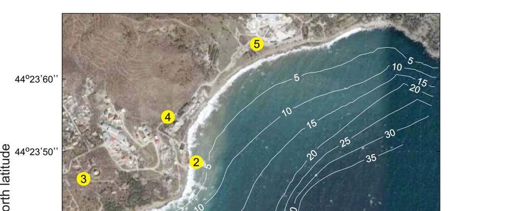
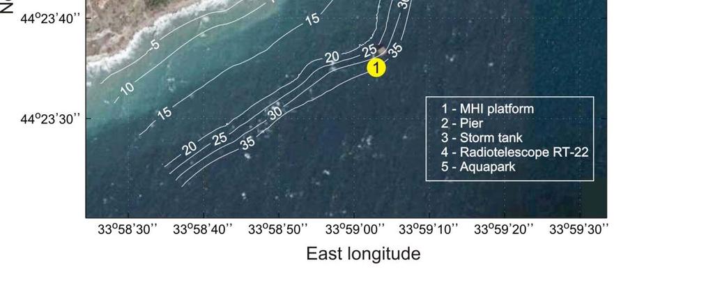
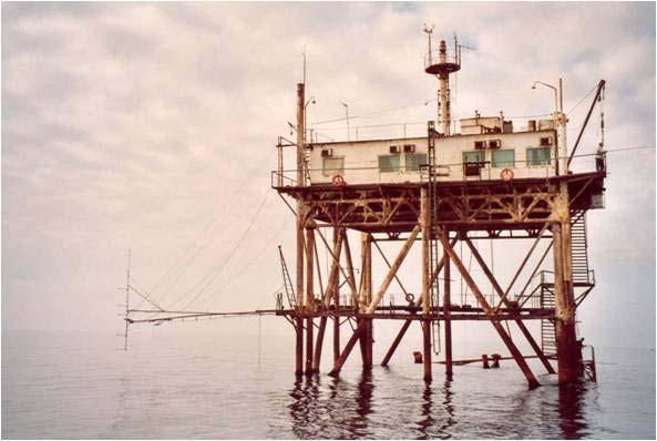
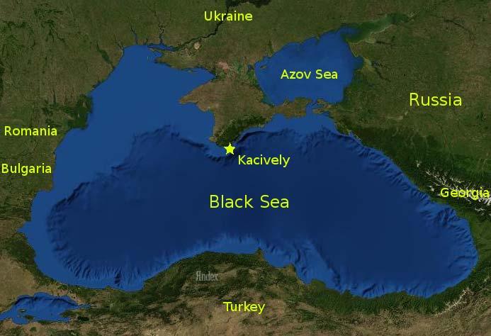
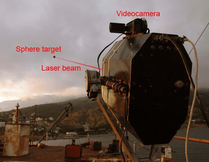
3 Marine Hydrophysical Institute (MHI) Research platform
")
 100 mw Conical horns for Tx and Rx + weather")
4 Instruments Radar Polarization Wavelength Power Antenna design CW dual-polarized Doppler hybrid polarization, slant (45 o ) transmit polarization plane VV, HH 8 mm, 37.5 GHz (Ka-band) 100 mw Conical horns for Tx and Rx + weather station and wire wave guage

5 Measurements, wind swell
6 Calibration and pattern correction
7 Radar antenna pattern (transmit + receive)
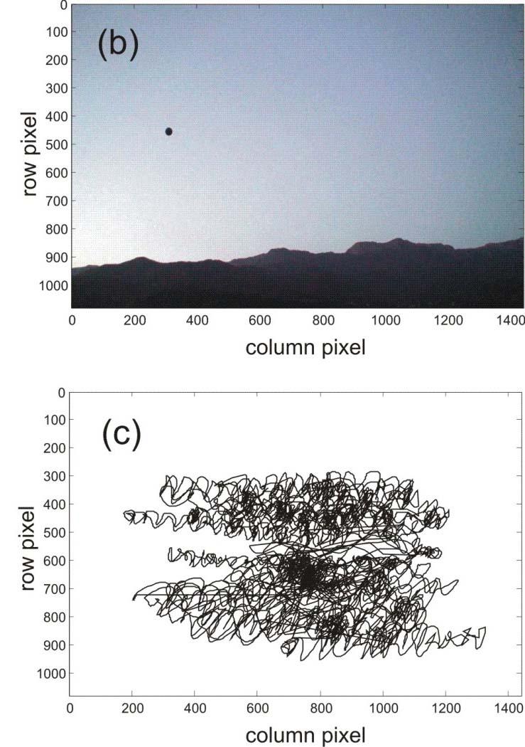
8 Surface Currents (i) (ii) Direct marker velocity on video records Indirect current meter at z=10m (V10) + empirical wind driven velocity shear, 0.023*U10 Scatter diagram of surface current speed (blue points) and direction (red points) from (xaxis) video data and (y axis) current at z=10 m corrected for wind driven shear in the upper 10m.
 Doppler Velocity, /, where is the radar wavenumber.")
9 * Digitization rate 40 khz Processing * Instantaneous Doppler spectrum,,, is computed from 0.2s segments using in phase,, quadrature,, components. * Instantaneous NRCS,,, Doppler frequency,, /, and Doppler bandwidth,, / * Instantaneous line of sight (LOS) Doppler Velocity, /, where is the radar wavenumber. Sample VV Doppler spectrum ( =53 o, upwind, =10 m/s) as a function of time. Doppler velocity (yellow, middle line), Doppler spectrum width (cyan, top and bottom lines). Shades correspond to spectrum density.
![Time series PR 10 [db] 0 DV / Sample timeseries of polarization ratio (PR= and Doppler velocity](/docs-images/80/81455800/images/10-0.jpg "(DV, [m/s]).")
10 Time series PR 10 [db] 0 DV / Sample timeseries of polarization ratio (PR= and Doppler velocity (DV, [m/s]). Positive DV corresponds to wave crests where PR decreases occasionally to 0 [db], (PR=1).
11 Strong peaks of the NRCS occur in phase with minima in the polarization ratio (PR), which occasionally drops down to 1 (0 db). Such weakly polarized events are associated with wave breaking, but surprisingly do not cause Doppler velocity spikes. An expected magnitude of such spikes is of the order of phase velocity of breaking wave. Because PR 1, such occasional strong breakers cover almost entire radar footprint of ~2m. The wavelength of carrying breaking wave should be at least 10 times of the footprint size, 20m, that corresponds to the phase speed of 5 m/s. Apparently, the highest IDV values are well beyond that level. This suggests that intrinsic breaker velocity is lower than the phase velocity of the carrying breaking wave. Wave breaking contributes to the NRCS and is strongly modulated by the LW. Breaking instability develops on LW crests and propagates with its phase speed. But once a breaking crest is broken, it generates disturbances that are embedded in water, and thus move with LW orbital velocity. This observation is in contrast with the previous assumption employed in Doppler echo models that associate the intrinsic speed of breaker related scattering facet with the phase speed of the breaking wave.

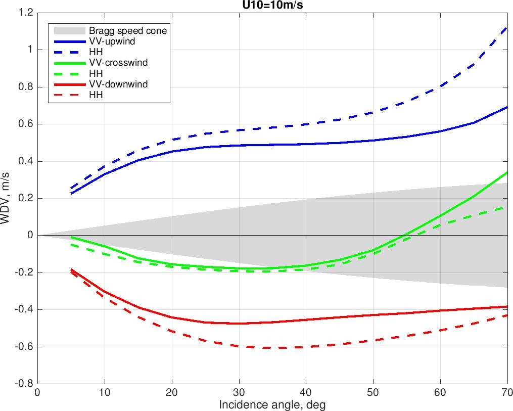
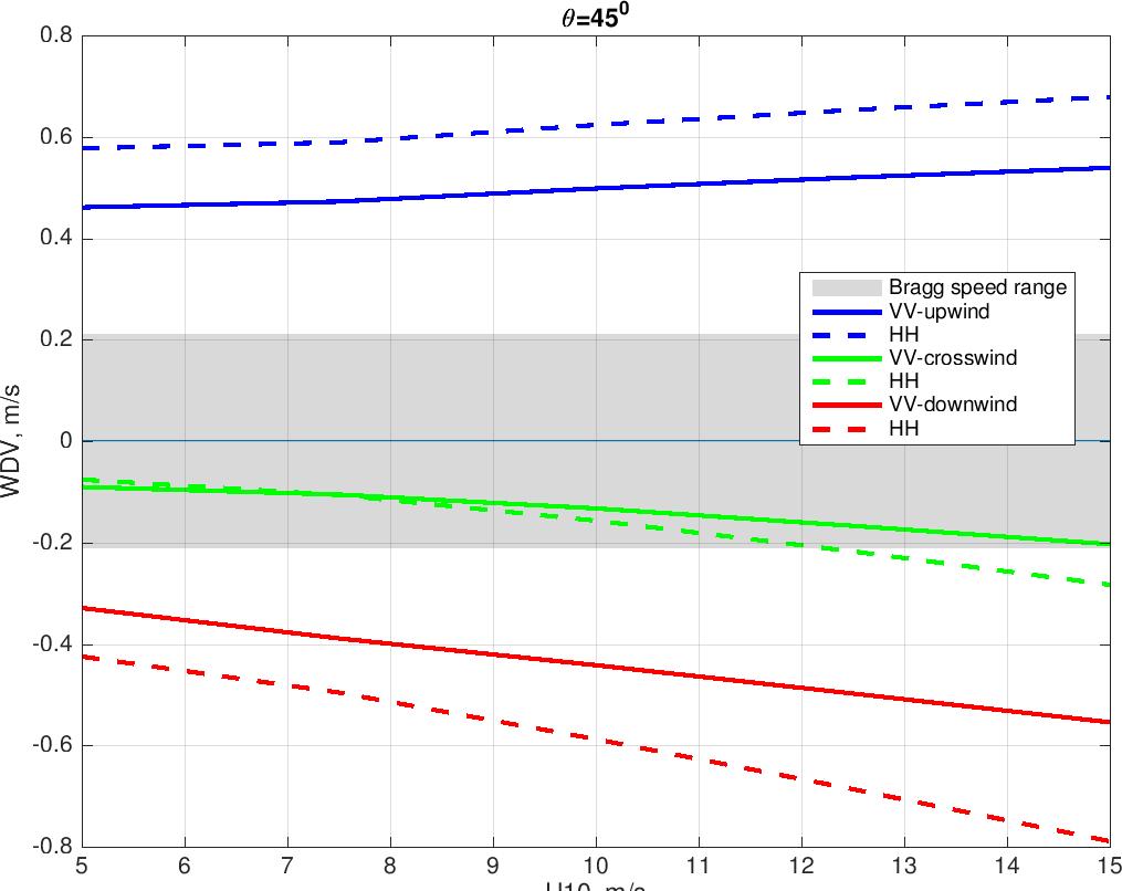
12 Scatter diagrams, U10=10m/s, upwind, incidence angle =53 o NRCS vs Doppler velocity Polarization ratio vs Doppler velocity (DV) Pure Bragg Mostly Bragg scattering from wave troughs Composite scattering from wave crests No wave breaking induced spikes in DV. Intrinsic speed of wave breaking facets is lower than LW phase speed troughs Mean current crests
13 Doppler velocity parameterization (KaDop) Satellite Doppler radar detects NRCS weighted DV, /, where and are the time mean LOS Doppler velocity and NRCS, and v and σ are wave induced fluctuations. Instantaneous Doppler Velocity (IDV) measured by an ideal radar with infinitively narrow antenna pattern ( a research platform based radar), IDV=v+v. Simple time mean,, while NRCS weighted time average, /, is similar to satellite measurements. Time mean IDV equals to the sum of surface current and time mean scatter velocity,.after removing the surface current from observed DV, the intrinsic scatter velocity is represented as, Δ. WDV= cos cos / cos sin Δ WIDV The residual term, c, accounts for contributions of non Bragg scattering and the averaging effect of antenna footprint. It primarily depends on observation geometry and is parametrized as polynomials of and. Dependence on the sea state (wind speed, etc) is omitted.
 estimates. Solid lines are. Colors correspond to radar to wind azimuth, symbol size ~ U10.")
14 Instantaneous (IDV) and sigma weighted (WDV) Doppler velocity for drift corrected (solid symbols) and non corrected (transparent symbols) estimates. Solid lines are. Colors correspond to radar to wind azimuth, symbol size ~ U10. VV HH downwind IDV WDV upwind

15 Wave Induced Doppler Velocity (WIDV= ) parameterization * NRCS variation,, is related to Long Wave (LW) elevation,, via the traditional radar modulation transfer function (MTF): / * DV fluctuations produced by LW orbital velocity:, Ω, where cos sin cos is the geometric transformation coefficient projecting the wave orbital velocity onto the radar LOS direction. * WIDV is represented in terms of the MTF: * MTF is inferred from Doppler radar data:. Impact of hydrodynamics MTF on WIDV If ripple doesn t vary along long wave, the LW orbital velocities average out. If ripple is present only on long wave crests, the WIDV~ orbital velocity~0.1*u10~1m/s.

16 Measured magnitude and phase of Ka band MTF VV HH phase magnitude Symbol size ~U10, colors radar to wind direction (blue upwind). MTF is averaged over LW frequency range,. Cutoff corresponds to antenna ground footprint. Observed MTF magnitude and phase are almost constant within LW frequency range from the wave peak to the cutoff scale (defined by antenna footprint size),. Magnitude and phase of MTF averaged over this frequency range are fitted by polynomials of,, and log. For given MTF, WIDV is calculated using the Toba (1973) spectrum.

17 KaDop and observed sigma weighted Doppler velocity, WDV
18 General characteristics of empirical KaDop.
19 Comparisons with empirical Cdop of Mouche et al. (2012) and DopRIMmodel (for Ka band)
20 Summary and Questions Platform data provide both the Instantaneous (IDV) and the NRCS Weighted (WDV) Doppler Velocity to distinguish between the mean scattering facet velocity and the Wave Induced Doppler Velocity (WIDV). The WDV is a proxy for satellite measurements that are averaged over spatially large ground footprint. After subtracting the surface current, the time mean Ka band IDV is close to. The difference from is parametrized as a function of observation geometry only. WIDV is parameterized in terms of the Modulation Transfer Function (MTF) that is derived from radar measurements using DV as a proxy for wave gauge. Ka band WDV weakly depends on incidence angle and wind speed. Characteristic deviation of WDV from the line of sight Bragg speed is about cm/s, which is parametrized as a function of observation geometry and wind speed (an empirical KaDop). Non polarized scattering (PR~1) from sharp and fast breaking facets don t pair with Doppler velocity spikes (order of the phase speed of breaking wave). Breaking instability develops on LW crests and propagates with its phase speed. But once a breaking crest is broken, it generates disturbances that are embedded in water and propagate with LW orbital velocity.
21 Summary and Questions (continued) KaDop needs verification against independent measurements. KaDop is based on wind sea (excluding swell). What is possible impact of swell? At given conditions and observation geometry, Ka band KaDop predicts smaller Doppler velocity than C band CDop. Why wave contribution to Ka band Doppler velocity is weaker than that in the C band?
Densità spettrale di clutter
 Densità spettrale di clutter Pierfrancesco Lombardo RRSN DIET, Università di Roma La Sapienza CLUTTER SPECTRA 1 Power Spectral Density (PSD) models Correct spectral shape impacts clutter cancellation and
China France. Oceanography S A T. The CFOSAT project. e l l i t e. C. Tison (1), D. Hauser (2), A. Mouche (3) CNES, France (2)
, D. Hauser (2), A. Mouche (3) CNES, France (2)") China France The CFOSAT project C. Tison (1), D. Hauser (2), A. Mouche (3) (1) CNES, France (2) OVSQ, CNRS, LATMOS-IPSL, France (3) IFREMER, LOS, France celine.tison@cnes.fr Oceanography S A T e l l i
China France The CFOSAT project C. Tison (1), D. Hauser (2), A. Mouche (3) (1) CNES, France (2) OVSQ, CNRS, LATMOS-IPSL, France (3) IFREMER, LOS, France celine.tison@cnes.fr Oceanography S A T e l l i
Dependencies of the Doppler Velocity from X-Band Backscatter at Grazing Incidence
 SOMaR-4 Workshop Dependencies of the Doppler Velocity from X-Band Backscatter at Grazing Incidence 9-11th of May, 2017 / Lüneburg Michael Streßer Ruben Carrasco, Marius Cysewski, Jörg Seemann and Jochen
A study of the slope probability density function of the ocean waves from radar observations
 Click Here for Full Article JOURNAL OF GEOPHYSICAL RESEARCH, VOL. 113,, doi:10.1029/2007jc004264, 2008 A study of the slope probability density function of the ocean waves from radar observations D. Hauser,
Wave number spectrum and mean square slope of intermediate-scale ocean surface waves
 JOURNAL OF GEOPHYSICAL RESEARCH, VOL. 110,, doi:10.1029/2005jc003002, 2005 Wave number spectrum and mean square slope of intermediate-scale ocean surface waves Paul A. Hwang Oceanography Division, Naval
Lecture 19: Operational Remote Sensing in Visible, IR, and Microwave Channels
 MET 4994 Remote Sensing: Radar and Satellite Meteorology MET 5994 Remote Sensing in Meteorology Lecture 19: Operational Remote Sensing in Visible, IR, and Microwave Channels Before you use data from any
Three-scale Radar Backscattering Model of the Ocean Surface Based on Second-order Scattering
 PIERS ONLINE, VOL. 4, NO. 2, 2008 171 Three-scale Radar Backscattering Model of the Ocean Surface Based on Second-order Scattering Ying Yu 1, 2, Xiao-Qing Wang 1, Min-Hui Zhu 1, and Jiang Xiao 1, 1 National
Optical and radar observations of steep and breaking waves of decimeter range ( mesowaves ) on the sea surface: electrodynamical and hydrophysical
 on the sea surface: electrodynamical and hydrophysical") Optical and radar observations of steep and breaking waves of decimeter range ( mesowaves ) on the sea surface: electrodynamical and hydrophysical interpretation Kravtsov Yu.A., Bulatov M.G., Raev M.D.,
Optical and radar observations of steep and breaking waves of decimeter range ( mesowaves ) on the sea surface: electrodynamical and hydrophysical interpretation Kravtsov Yu.A., Bulatov M.G., Raev M.D.,
Long term performance monitoring of ASCAT-A
 Long term performance monitoring of ASCAT-A Craig Anderson and Julia Figa-Saldaña EUMETSAT, Eumetsat Allee 1, 64295 Darmstadt, Germany. Abstract The Advanced Scatterometer (ASCAT) on the METOP series of
NAIC NAIC PLANETARY RADAR ASTRONOMY STUDYING SOLAR SYSTEM BODIES WITH RADAR DON CAMPBELL
 NAIC PLANETARY RADAR ASTRONOMY or STUDYING SOLAR SYSTEM BODIES WITH RADAR DON CAMPBELL NAIC NAIC PLANETARY RADAR ASTRONOMY NAIC GOOD ASPECTS Transmitted signal Can control: Power Polarization Frequency
MICROWAVE DOPPLER SPECTRA OF SEA ECHOES AT HIGH INCIDENCE ANGLES: INFLUENCES OF LARGE- SCALE WAVES
 Progress In Electromagnetics Research B, Vol. 8, 99 113, 13 MICROWAVE DOPPLER SPECTRA OF SEA ECHOES AT HIGH INCIDENCE ANGLES: INFLUENCES OF LARGE- SCALE WAVES Yunhua Wang 1, *, Yanmin Zhang, and Lixin
INDIVIDUAL WAVE HEIGHT FROM SAR
 INDIVIDUAL WAVE HEIGHT FROM SAR W. Rosenthal (1), S.Lehner (2) (1), GKSS, D 2102 Geesthacht, Email:Wolfgang.Rosenthal@gkss.de (2), DLR, D82234 Wessling,, Email:Susanne.Lehner@dlr.de ABSTRACT Safety of
Friis Transmission Equation and Radar Range Equation 8.1 Friis Transmission Equation
 Friis Transmission Equation and Radar Range Equation 8.1 Friis Transmission Equation Friis transmission equation is essential in the analysis and design of wireless communication systems. It relates the
Ship-Based Measurements of Cloud Microphysics and PBL Properties in Precipitating Trade Cumuli During RICO
 Ship-Based Measurements of Cloud Microphysics and PBL Properties in Precipitating Trade Cumuli During RICO Institutions: University of Miami; University of Colorado; NOAA ETL Investigators: P. Kollias
Orbit and Transmit Characteristics of the CloudSat Cloud Profiling Radar (CPR) JPL Document No. D-29695
 JPL Document No. D-29695") Orbit and Transmit Characteristics of the CloudSat Cloud Profiling Radar (CPR) JPL Document No. D-29695 Jet Propulsion Laboratory California Institute of Technology Pasadena, CA 91109 26 July 2004 Revised
Orbit and Transmit Characteristics of the CloudSat Cloud Profiling Radar (CPR) JPL Document No. D-29695 Jet Propulsion Laboratory California Institute of Technology Pasadena, CA 91109 26 July 2004 Revised
Archimer
 Please note that this is an author-produced PDF of an article accepted for publication following peer review. The definitive publisher-authenticated version is available on the publisher Web site Remote
P7.5 STUDIES OF SEA SURFACE NORMALIZED RADAR CROSS SECTIONS OBSERVED BY CLOUDSAT
 P7.5 STUDIES OF SEA SURFACE NORMALIZED RADAR CROSS SECTIONS OBSERVED BY CLOUDSAT Ninoslav Majurec 1, Joel T. Johnson 1, and Simone Tanelli 1 ElectroScience Laboratory, The Ohio State University, Columbus,
III. Spherical Waves and Radiation
 III. Spherical Waves and Radiation Antennas radiate spherical waves into free space Receiving antennas, reciprocity, path gain and path loss Noise as a limit to reception Ray model for antennas above a
RADAR TARGETS IN THE CONTEXT OF EARTH OBSERVATION. Dr. A. Bhattacharya
 RADAR TARGETS IN THE CONTEXT OF EARTH OBSERVATION Dr. A. Bhattacharya 1 THE RADAR EQUATION The interaction of the incident radiation with the Earth s surface determines the variations in brightness in
EVALUATING THE QUIKSCAT/SEAWINDS RADAR FOR MEASURING RAINRATE OVER THE OCEANS USING COLLOCATIONS WITH NEXRAD AND TRMM
 JP2.9 EVALUATING THE QUIKSCAT/SEAWINDS RADAR FOR MEASURING RAINRATE OVER THE OCEANS USING COLLOCATIONS WITH NEXRAD AND TRMM David E. Weissman* Hofstra University, Hempstead, New York 11549 Mark A. Bourassa
SAR Raw Signal Simulation of Oil Slicks in Ocean Environments
 IEEE TRANSACTIONS ON GEOSCIENCE AND REMOTE SENSING, VOL. 40, NO. 9, SEPTEMBER 2002 1935 SAR Raw Signal Simulation of Oil Slicks in Ocean Environments Giorgio Franceschetti, Life Fellow, IEEE, Antonio Iodice,
DEMOSS. Title: Development of Marine Oil Spills/slicks Satellite monitoring System elements for the Black Sea, Caspian Sea and /Kara/Barents Seas
 DEMOSS Title: Development of Marine Oil Spills/slicks Satellite monitoring System elements for the Black Sea, Caspian Sea and /Kara/Barents Seas INTAS Thematic Call on Earth Sciences and Environment in
Earth Exploration-Satellite Service (EESS)- Active Spaceborne Remote Sensing and Operations
- Active Spaceborne Remote Sensing and Operations") Earth Exploration-Satellite Service (EESS)- Active Spaceborne Remote Sensing and Operations SRTM Radarsat JASON Seawinds TRMM Cloudsat Bryan Huneycutt (USA) Charles Wende (USA) WMO, Geneva, Switzerland
Earth Exploration-Satellite Service (EESS)- Active Spaceborne Remote Sensing and Operations SRTM Radarsat JASON Seawinds TRMM Cloudsat Bryan Huneycutt (USA) Charles Wende (USA) WMO, Geneva, Switzerland
Snow Microphysical Retrieval Based on Ground Radar Measurements
 Snow Microphysical Retrieval Based on Ground Radar Measurements V. Chandrasekar Colorado State University June 27, 2007 1 Outline Role of inter comparing ground and space borne radar Class of measurements
Shipborne polarimetric weather radar: Impact of ship movement on polarimetric variables
 Shipborne polarimetric weather radar: Impact of ship movement on polarimetric variables M. Thurai 1, P. T. May and A. Protat 1 Colorado State Univ., Fort Collins, CO Center for Australian Weather and Climate
Investigation of Speed Comparator Operating Features Above the Sea Surface
 Investigation of Speed Comparator Operating Features Above the Sea Surface Dmitriy P. Sedov Ural Federal University Yekaterinburg, Russia, sedovdp@rambler.ru Vladimir G. Vazhenin Ural Federal University
Mandatory Assignment 2013 INF-GEO4310
 Mandatory Assignment 2013 INF-GEO4310 Deadline for submission: 12-Nov-2013 e-mail the answers in one pdf file to vikashp@ifi.uio.no Part I: Multiple choice questions Multiple choice geometrical optics
Lecture 20. Wind Lidar (2) Vector Wind Determination
 Vector Wind Determination") Lecture 20. Wind Lidar (2) Vector Wind Determination Vector wind determination Ideal vector wind measurement VAD and DBS technique for vector wind Coherent versus incoherent Detection Doppler wind lidar
Lecture 20. Wind Lidar (2) Vector Wind Determination Vector wind determination Ideal vector wind measurement VAD and DBS technique for vector wind Coherent versus incoherent Detection Doppler wind lidar
Routine high resolution observation of selected major surface currents from space
 1 Routine high resolution observation of selected major surface currents from space Fabrice Collard(1), Alexis Mouche(1), Celine Danilo(1), Bertrand Chapron(2), Jordi Isern-Fontanet(2), Johnny Johannessen(3)
Sentinel-1 A: Status & Opportunities
 Sentinel-1 A: Status & Opportunities A. Mouche, Ifremer in collaboration with Sentinel-1 ESL Team (Aresys, BAES, CLS, ESA, NORUT, ODL & UZH) Ifremer, Laboratoire Océanographie Spatiale Team (B. Chapron,
Analysis of Doppler signals from nadir altimeters over ocean. F. Boy (CNES)
") Analysis of Doppler signals from nadir altimeters over ocean F. Boy (CNES) Delay-Doppler Phase Altimetry of Radar Altimeter Pulses Launched in 2016, Sentinel-3A has been measuring oceans, land, ice to
Analysis of Doppler signals from nadir altimeters over ocean F. Boy (CNES) Delay-Doppler Phase Altimetry of Radar Altimeter Pulses Launched in 2016, Sentinel-3A has been measuring oceans, land, ice to
Incoherent Scatter theory and its application at the magnetic Equator
 Incoherent Scatter theory and its application at the magnetic Equator Marco A. Milla Radio Observatorio de Jicamarca Instituto Geofísico del Perú JIREP Seminar, June 3, 2013 Jicamarca Radio Observatory
HY-2A Satellite User s Guide
 National Satellite Ocean Application Service 2013-5-16 Document Change Record Revision Date Changed Pages/Paragraphs Edit Description i Contents 1 Introduction to HY-2 Satellite... 1 2 HY-2 satellite data
Remote Sensing in Meteorology: Satellites and Radar. AT 351 Lab 10 April 2, Remote Sensing
 Remote Sensing in Meteorology: Satellites and Radar AT 351 Lab 10 April 2, 2008 Remote Sensing Remote sensing is gathering information about something without being in physical contact with it typically
Lecture 8 Notes, Electromagnetic Theory II Dr. Christopher S. Baird, faculty.uml.edu/cbaird University of Massachusetts Lowell
 Lecture 8 Notes, Electromagnetic Theory II Dr. Christopher S. Baird, faculty.uml.edu/cbaird University of Massachusetts Lowell 1. Scattering Introduction - Consider a localized object that contains charges
Analysis of Infrared Measurements of Microbreaking and Whitecaps
 Analysis of Infrared Measurements of Microbreaking and Whitecaps Andrew T. Jessup Applied Physics Laboratory, University of Washington 1013 NE 40th St. Seattle, WA 98105-6698 phone (206) 685-2609 fax (206)
Two-scale treatment of low-grazing-angle scattering from spilling breaker water waves
 RADIO SCIENCE, VOL. 37, NO. 4, 1054, 10.1029/2001RS002517, 2002 Two-scale treatment of low-grazing-angle scattering from spilling breaker water waves James C. West and Shiou-Jyh Ja 1 School of Electrical
Remote Sensing Observations AOSC 200 Tim Canty
 Remote Sensing Observations AOSC 200 Tim Canty Class Web Site: http://www.atmos.umd.edu/~tcanty/aosc200 Topics for today: Maps Radar Satellite Observations Lecture 04 Feb 7 2019 1 Today s Weather Map http://www.wpc.ncep.noaa.gov/sfc/namussfcwbg.gif
Training Course on Radar & Optical RS, IES, Cēsis, Latvia, 5-9 September SAR Marine Applications. Practicals
 SAR Marine Applications Practicals Martin Gade Uni Hamburg, Institut für Meereskunde martin.gade@uni-hamburg.de SAR Marine Applications Friday, 9 Sep, Morning: 1 - History & Basics Introduction Radar/SAR
Ecography. Supplementary material
 Ecography ECOG-04028 Dokter, A. M., Desmet, P., Spaaks, J. H., van Hoey, S., Veen, L., Verlinden, L., Nilsson, C., Haase, G., Leijnse, H., Farnsworth, A., Bouten, W. and Shamoun-Baranes, J. 2019. biorad:
Physics of the Convective Boundary Layer based on Radar/Lidar Profiler measurements and simulation
 Physics of the Convective Boundary Layer based on Radar/Lidar Profiler measurements and simulation D. Vanhoenacker Janvier (1), A. Graziani (1), D. Kovalev (1), C. Pereira (1), M. Duponcheel (2), R. Wilson
Progress In Electromagnetics Research, Vol. 119, , 2011
 Progress In Electromagnetics Research, Vol. 119, 279 298, 211 INVESTIGATION OF LOW-GRAZING-ANGLE MICROWAVE BACKSCATTERING FROM THREE- DIMENSIONAL BREAKING SEA WAVES W. Luo 1, M. Zhang 1, *, C. Wang 2,
Observation strategies for severe rain in The Netherlands
 Observation strategies for severe rain in The Netherlands Herman Russchenberg Delft University of Technology Challenge the future Our Earth is slowly warming The world population is moving into the cities
Q-Winds Hurricane Retrieval Algorithm using QuikSCAT Scatterometer
 Q-Winds Hurricane Retrieval Algorithm using QuikSCAT Scatterometer Pete Laupattarakasem Doctoral Dissertation Defense March 23 rd, 2009 Presentation Outline Dissertation Objective Background Scatterometry/Radiometry
Lecture 11: Doppler wind lidar
 Lecture 11: Doppler wind lidar Why do we study winds? v Winds are the most important variable studying dynamics and transport in the atmosphere. v Wind measurements are critical to improvement of numerical
Scattering from Surf Zone Waves
 Scattering from Surf Zone Waves Experimental Results and Modeling Patricio, Merrick Haller, Bill Plant Associate Professor Universidad Técnica Federico Santa María Chile Motivation Wave Breaking 2 Background
The Nature of Light. We have a dual model
 Light and Atoms Properties of Light We can come to understand the composition of distant bodies by analyzing the light they emit This analysis can tell us about the composition as well as the temperature
Marketed and Distributed By FaaDoOEngineers.com
 WAVES GUPTA CLASSES For any help contact: 995368795, 968789880 Nishant Gupta, D-, Prashant vihar, Rohini, Delhi-85 Waves Wave motion A wave motion is a kind of disturbance which is transferred from one
Convective Structures in Clear-Air Echoes seen by a Weather Radar
 Convective Structures in Clear-Air Echoes seen by a Weather Radar Martin Hagen Deutsches Zentrum für Luft- und Raumfahrt Oberpfaffenhofen, Germany Weather Radar Weather radar are normally used to locate
Direct measurements of ocean surface velocity from space: Interpretation and validation
 Please note that this is an author-produced PDF of an article accepted for publication following peer review. The definitive publisher-authenticated version is available on the publisher Web site JOURNAL
IOVWST Meeting, Sapporo/Japan, May 2016
 IOVWST Meeting, Sapporo/Japan, May 2016 The Design and Performance of the SCA Radar carried by the METOP Second Generation Satellites J. J. W. Wilson, C. Anderson EUMETSAT, Darmstadt, Germany. A. Ostergaard,
THE IMPACT OF GROUND-BASED GPS SLANT-PATH WET DELAY MEASUREMENTS ON SHORT-RANGE PREDICTION OF A PREFRONTAL SQUALL LINE
 JP1.17 THE IMPACT OF GROUND-BASED GPS SLANT-PATH WET DELAY MEASUREMENTS ON SHORT-RANGE PREDICTION OF A PREFRONTAL SQUALL LINE So-Young Ha *1,, Ying-Hwa Kuo 1, Gyu-Ho Lim 1 National Center for Atmospheric
Lecture 2. Fading Channel
 1 Lecture 2. Fading Channel Characteristics of Fading Channels Modeling of Fading Channels Discrete-time Input/Output Model 2 Radio Propagation in Free Space Speed: c = 299,792,458 m/s Isotropic Received
Performance of Antenna Measurement Setup
 Performance of Antenna Measurement Setup Raul Monsalve SESE, Arizona State University November 27, 213 2 Description This report is divided into two parts: PART 1: Check of recovered instrumental S-parameters
Incoherent Scatter theory and its application at the magnetic Equator
 Incoherent Scatter theory and its application at the magnetic Equator Marco A. Milla Radio Observatorio de Jicamarca Instituto Geofísico del Perú JIREP Seminar, June 2018 Jicamarca Radio Observatory Jicamarca
Lecture 15: Doppler Dilemma, Range and Velocity Folding, and Interpreting Doppler velocity patterns
 MET 4410 Remote Sensing: Radar and Satellite Meteorology MET 5412 Remote Sensing in Meteorology Lecture 15: Doppler Dilemma, Range and Velocity Folding, and Interpreting Doppler velocity patterns Doppler
Effect of rain on Ku band fan beam Scatterometer
 Effect of rain on Ku band fan beam Scatterometer J. Tournadre, Y. Quilfen, B. Chapron Laboratoire d'océanographie Spatiale Ifremer Brest Problem/Drawback of the use of Ku-Band for radar SCAT on the future
Ice sheet mass balance from satellite altimetry. Kate Briggs (Mal McMillan)
") Ice sheet mass balance from satellite altimetry Kate Briggs (Mal McMillan) Outline Background Recap 25 year altimetry record Recap Measuring surface elevation with altimetry Measuring surface elevation
Ice sheet mass balance from satellite altimetry Kate Briggs (Mal McMillan) Outline Background Recap 25 year altimetry record Recap Measuring surface elevation with altimetry Measuring surface elevation
Maps and Remote Sensing AOSC 200 Tim Canty
 Maps and Remote Sensing AOSC 200 Tim Canty Class Web Site: http://www.atmos.umd.edu/~tcanty/aosc200 Topics for today: Weather Maps Radar Satellite Observations Lecture 04 Feb 7 2019 1 Today s Weather Map
1 The satellite altimeter measurement
 1 The satellite altimeter measurement In the ideal case, a satellite altimeter measurement is equal to the instantaneous distance between the satellite s geocenter and the ocean surface. However, an altimeter
SATELLITE SYNTHETIC APERTURE RADAR SEA SURFACE DOPPLER MEASUREMENTS
 1 SATELLITE SYNTHETIC APERTURE RADAR SEA SURFACE DOPPLER MEASUREMENTS B. Chapron 1, F. Collard 2, and V. Kerbaol 2 1 Laboratoire d Océanographie Spatiale, IFREMER 2 BOOST-Technologies, Plouzané, France
Final Design and Testing of the 94 GHz Quasi-Optical-Feed for the EarthCARE S Cloud Profiling Radar
 Final Design and Testing of the 94 GHz Quasi-Optical-Feed for the EarthCARE S Cloud Profiling Radar J. Hartmann #, Chr. Hartwanger #, R. Wylde +, C. Cappellin*, H. Horie x # Astrium GmbH - Satellites,
Radar Detection Performance in Medium Grazing Angle X-band Sea-clutter
 Radar Detection Performance in Medium Grazing Angle X-band Sea-clutter Luke Rosenberg 1 and Stephen Bocquet 2 1 National Security and ISR Division 2 Joint and Operations Analysis Division Defence Science
Satellite Orbits.
 atellite Orbits It was announced few days ago that a 6-ton NAA weather no-longer functioning satellite that was launched in 1991 would crash into arth some time between Thursday, 22 eptember 2011 and aturday,
P14R.11 INFERENCE OF MEAN RAINDROP SHAPES FROM DUAL-POLARIZATION DOPPLER SPECTRA OBSERVATIONS
 P14R.11 INFERENCE OF MEAN RAINDROP SHAPES FROM DUAL-POLARIZATION DOPPLER SPECTRA OBSERVATIONS Dmitri N. Moisseev and V. Chandrasekar Colorado State University, Fort Collins, CO 1. INTRODUCTION Direct observations
RADAR REMOTE SENSING OF PLANETARY SURFACES
 RADAR REMOTE SENSING OF PLANETARY SURFACES BRUCE A. CAMPBELL Smithsonian Institution CAMBRIDGE UNIVERSITY PRESS Contents Acknowledgments page ix 1 Introduction 1 1.1 Radar remote sensing 1 1.2 Historical
Measurement of lower hybrid waves using microwave scattering technique in Alcator C-Mod
 Measurement of lower hybrid waves using microwave scattering technique in Alcator C-Mod S. Baek, R. Parker, S. Shiraiwa, A. Dominguez, E. Marmar, G. Wallace, G. J. Kramer* Plasma Science and Fusion Center,
Experiments with a Supported Dipole
 Experiments with a Supported Dipole Reporting Measurements of the Interchange Instability Excited by Electron Pressure and Centrifugal Force Introduction Ben Levitt and Dmitry Maslovsky Collisionless Terrella
Incoherent and Coherent Scatter Radars: Jicamarca examples
 Incoherent and Coherent Scatter Radars: Jicamarca examples R. F Woodman Radio Observatorio de Jicamarca, Instituto Geofísico del Perú, Lima Equatorial Aeronomy 1 Early History Equatorial Aeronomy 2 Model
The Evolution of Large-Amplitude Internal Gravity Wavepackets
 The Evolution of Large-Amplitude Internal Gravity Wavepackets Sutherland, Bruce R. and Brown, Geoffrey L. University of Alberta Environmental and Industrial Fluid Dynamics Laboratory Edmonton, Alberta,
P. Cipollini, H. Snaith - A short course on Altimetry. Altimetry 2 - Data processing (from satellite height to sea surface height)
") P. Cipollini, H. Snaith - A short course on Altimetry Altimetry 2 - Data processing (from satellite height to sea surface height) 1 2 Satellite height to sea surface height The altimeter measures the altitude
P. Cipollini, H. Snaith - A short course on Altimetry Altimetry 2 - Data processing (from satellite height to sea surface height) 1 2 Satellite height to sea surface height The altimeter measures the altitude
Satellite Remote Sensing SIO 135/SIO 236. Electromagnetic Radiation and Polarization
 Satellite Remote Sensing SIO 135/SIO 236 Electromagnetic Radiation and Polarization 1 Electromagnetic Radiation The first requirement for remote sensing is to have an energy source to illuminate the target.
EXTENDED UHF RADAR OBSERVATIONS OF RIVER FLOW VELOCITY AND COMPARISONS WITH IN-SITU MEASUREMENTS
 Proceedings of the Ninth International Symposium on River Sedimentation October 18 21, 2004, Yichang, China EXTENDED UHF RADAR OBSERVATIONS OF RIVER FLOW VELOCITY AND COMPARISONS WITH IN-SITU MEASUREMENTS
CALIBRATING THE QUIKSCAT/SEAWINDS RADAR FOR MEASURING RAINRATE OVER THE OCEANS
 CALIBRATING THE QUIKSCAT/SEAWINDS RADAR FOR MEASURING RAINRATE OVER THE OCEANS David E. Weissman Hofstra University, Hempstead, New York 11549 Mark A. Bourassa COAPS/The Florida State University, Tallahassee,
Sea state assimilation
 Sea state assimilation Peter Janssen ECMWF thanks to: Saleh Abdalla, Jean Bidlot and Hans Hersbach 1. INTRODUCTION Before we discuss the subject of assimilation of satellite observations
Observations of Arctic snow and sea ice thickness from satellite and airborne surveys. Nathan Kurtz NASA Goddard Space Flight Center
 Observations of Arctic snow and sea ice thickness from satellite and airborne surveys Nathan Kurtz NASA Goddard Space Flight Center Decline in Arctic sea ice thickness and volume Kwok et al. (2009) Submarine
to: Interseismic strain accumulation and the earthquake potential on the southern San
 Supplementary material to: Interseismic strain accumulation and the earthquake potential on the southern San Andreas fault system by Yuri Fialko Methods The San Bernardino-Coachella Valley segment of the
Polarimetric Calibration of the Ingara Bistatic SAR
 Polarimetric Calibration of the Ingara Bistatic SAR Alvin Goh, 1,2 Mark Preiss, 1 Nick Stacy, 1 Doug Gray 2 1. Imaging Radar Systems Group Defence Science and Technology Organisation 2. School of Electrical
Review Quantitative Aspects of Networking. Decibels, Power, and Waves John Marsh
 Review Quantitative spects of Networking Decibels, ower, and Waves John Marsh Outline Review of quantitative aspects of networking Metric system Numbers with Units Math review exponents and logs Decibel
12.3 The Doppler Effect
 12.3 The Doppler Effect Doppler Effect Fire engine doppler effect video Car doppler effect video Doppler Effect The pitch (frequency) of the horn of a passing car changes from high to low. This is due
The Quantum Sensor Challenge Designing a System for a Space Mission. Astrid Heske European Space Agency The Netherlands
 The Quantum Sensor Challenge Designing a System for a Space Mission Astrid Heske European Space Agency The Netherlands Rencontres de Moriond - Gravitation, La Thuile, 2017 Quantum Sensors in Lab Experiments
Numerical Studies of Backscattering from Time Evolving Sea Surfaces: Comparison of Hydrodynamic Models
 Numerical Studies of Backscattering from Time Evolving Sea Surfaces: Comparison of Hydrodynamic Models J. T. Johnson and G. R. Baker Dept. of Electrical Engineering/ Mathematics The Ohio State University
Simultaneous Observations of E-Region Coherent Backscatter and Electric Field Amplitude at F-Region Heights with the Millstone Hill UHF Radar
 Simultaneous Observations of E-Region Coherent Backscatter and Electric Field Amplitude at F-Region Heights with the Millstone Hill UHF Radar J. C. Foster and P. J. Erickson MIT Haystack Observatory Abstract
SMALL-SCALE ATMOSPHERE-OCEAN COUPLING IN GALE-FORCE WINDS: MODELS, EXPERIMENTS, REMOTE SENSING
 SMALL-SCALE ATMOSPHERE-OCEAN COUPLING IN GALE-FORCE WINDS: MODELS, EXPERIMENTS, REMOTE SENSING YU. TROITSKAYA 1,2, D. SERGEEV 1,2, A. KANDAUROV 1,2, E. EZHOVA 1,2, O.DRUZHININ 1, I.SOUSTOVA 1,2, O.ERMAKOVA
Comparison of Bi-Modal Coherent Sea Clutter Models
 1 Comparison of Bi-Modal Coherent Sea Clutter Models Luke Rosenberg and Stephen Bocquet Defence Science and Technology Group, Australia Email: Luke.Rosenberg@dst.defence.gov.au Abstract Modelling and simulation
Multiple Antennas. Mats Bengtsson, Björn Ottersten. Channel characterization and modeling 1 September 8, Signal KTH Research Focus
 Multiple Antennas Channel Characterization and Modeling Mats Bengtsson, Björn Ottersten Channel characterization and modeling 1 September 8, 2005 Signal Processing @ KTH Research Focus Channel modeling
Near-surface Measurements In Support of Electromagnetic Wave Propagation Study
 DISTRIBUTION STATEMENT A. Approved for public release; distribution is unlimited. Near-surface Measurements In Support of Electromagnetic Wave Propagation Study Qing Wang Meteorology Department, Naval
S and Ka-band reflectivity comparison
 S and Ka-band reflectivity comparison For Rayleigh scattering and in the absence of propagation effects, the true S and Kaband reflectivity values are equivalent Measured S and Ka-band radar reflectivity
Meteorology 311. RADAR Fall 2016
 Meteorology 311 RADAR Fall 2016 What is it? RADAR RAdio Detection And Ranging Transmits electromagnetic pulses toward target. Tranmission rate is around 100 s pulses per second (318-1304 Hz). Short silent
The Doppler effect for SAR 1
 The Doppler effect for SAR 1 Semyon Tsynkov 2,3 3 Department of Mathematics North Carolina State University, Raleigh, NC 2016 AFOSR Electromagnetics Contractors Meeting January 5 7, 2016, Arlington, VA
Class Average = 71. Counts Scores
 30 Class Average = 71 25 20 Counts 15 10 5 0 0 20 10 30 40 50 60 70 80 90 100 Scores Chapter 12 Mechanical Waves and Sound To describe mechanical waves. To study superposition, standing waves, and interference.
Galactic Structure Mapping through 21cm Hyperfine Transition Line
 Galactic Structure Mapping through 21cm Hyperfine Transition Line Henry Shackleton MIT Department of Physics (Dated: May 14, 2017) Using a Small Radio Telescope (SRT), we measure electromagnetic radiation
Signature 55 Long Range Current Profiler Data from a Short Deployment Lee Gordon Doppler Ltd. January 7, 2015 This report presents
 Signature 55 Long Range Current Profiler Data from a Short Deployment Lee Gordon Doppler Ltd. lee@dopplerltd.com January 7, 215 This report presents and evaluates data collected by a Nortek Signature 55
Radar Remote Sensing of Ice and Sea State and Air-Sea Interaction in the Marginal Ice Zone
 DISTRIBUTION STATEMENT A. Approved for public release; distribution is unlimited. Radar Remote Sensing of Ice and Sea State and Air-Sea Interaction in the Marginal Ice Zone Hans C. Graber RSMAS Department
Sentinels and Waves. GMES Sentinel-1 SAR GMES Sentinel-3 Altimeter
 Sentinels and Waves GMES Sentinel-1 SAR GMES Sentinel-3 Altimeter Simon Pinnock, ESA-ESRIN, Frascati, Italy with help from Craig Donlon (ESTEC) & Nuno Miranda (ESRIN) et al. GMES Space Component: dedicated
B 2 = ɛ o. E o B o. B 2 = 1 µ o. E B. Note that the direction of the vector S gives the direction of propagation of the wave.
 Physics 33 : Chapter 31 Examples : Electromagnetic Waves Maxwell s equations relate electric and magnetic fields in fairly complex ways, involving space and time derivatives of each other. Combining these
REALIZATION OF A MATCHING REGION BETWEEN A RADOME AND A GROUND PLANE
 Progress In Electromagnetics Research Letters, Vol. 17, 1 1, 21 REALIZATION OF A MATCHING REGION BETWEEN A RADOME AND A GROUND PLANE D. Sjöberg and M. Gustafsson Department of Electrical and Information
Comparative Study of LEO, MEO & GEO Satellites
 Comparative Study of LEO, MEO & GEO Satellites Smridhi Malhotra, Vinesh Sangwan, Sarita Rani Department of ECE, Dronacharya College of engineering, Khentawas, Farrukhnagar, Gurgaon-123506, India Email:
Measuring Changes in Ice Flow Speeds
 Measuring Changes in Ice Flow Speeds Ice flow speeds are commonly measured using a technique called Interferometric Synthetic Aperture Radar (InSAR). This is an active imaging technique the instrument
Chapter 27. Current And Resistance
 Chapter 27 Current And Resistance Electric Current Electric current is the rate of flow of charge through some region of space The SI unit of current is the ampere (A) 1 A = 1 C / s The symbol for electric