Sentinel-1 Long Duration Mutual Interference
|
|
|
- Poppy Sybil Singleton
- 5 years ago
- Views:
Transcription
1 MPC-S1 Sentinel-1 Long Duration Mutual Interference Reference: Nomenclature: MPC-0432 DI-MPC-ARC Issue: 1. 0 Date: 2018,Dec.04
2 MPC-0432 DI-MPC-ARC V ,Dec.04 i.1 Chronology Issues: Issue: Date: Reason for change: Author Initial version Peter Meadows People involved in this issue: Written by (*): P.J Meadows Date + Initials (visa or ref) Checked by (*): P.J Meadows Date + Initial (visa ou ref) P.J.Meadows Approved by (*): G.Hajduch Date + Initial (visa ou ref) G.Hajduch Application authorized by (*): N. Miranda Date + Initial (visa ou ref) *In the opposite box: Last and First name of the person + company if different from CLS Index Sheet: Context: Keywords: Hyperlink: Report on long duration interference identified in Sentinel1-A & B imagery S-1A, S-1B, Interference N/A
3 MPC-0432 DI-MPC-ARC V ,Dec.04 i.2 List of tables and figures List of tables: Table 1: Sentinel-1 and Radarsat-2 Orbit Characteristics... 2 Table 2: List of S1-A Data with S1/RS2 Mutual Interference Table 3: List of S1-B Data with S1/RS2 Mutual Interference Table 4: Sentinel-1 and GAOFEN 3 Orbit Characteristics *deduced values Table 5: Sentinel-1 and Unknown Satellite Mutual Interference Occurrences List of figures: Figure 1: Relative Position of S1 and RS-2 (RD-1)... 3 Figure 2: Example simultaneous SAR imaging for S1 and RS Figure 3: S1-A RS-2 Crossing Locations (RD-1) Figure 4: S1-A RS-2 Mutual Interference over Italy (16th August 2015)... 5 Figure 5: S1-A RS-2 Mutual Interference over Italy (16th August 2015): L0 intensity (left) and full interference extent (right)... 7 Figure 6: RS-2 S1-A Mutual Interference over Italy (16th August 2015)... 7 Figure 7: Detail of RS-2 S1-A Mutual Interference over Italy (16th August 2015)... 8 Figure 8: S1-A RS-2 Mutual Interference from 3rd October 2015 over northern Italy/Switzerland Figure 9: S1-A RS-2 Mutual Interference from 5th February 2017 (top) and track of S1-A (bottom left) and RS-2 (bottom right) as viewed from Altay, China Figure 10: S1-B RS-2 Mutual Interference from 3rd May Figure 11: S1-A GAOFEN 3 Mutual Interference from 10th October Figure 12: Detail of S1-A GAOFEN 3 Mutual Interference from 10th October Figure 13: The track of S1-A (left) and RS-2 (right) as viewed from Liangshan, China Figure 14: S1-A Mutual Interference from 8th December Figure 15: Detail of S1-A Mutual Interference from 8th December Figure 16: S1-A Mutual Interference from 9th July Figure 17: Detail of S1-A Mutual Interference from 9th July Figure 18: S1-A Mutual Interference from 11th July Figure 19: Detail of S1-A Mutual Interference from 11th July Figure 20: S1-A Mutual Interference from 31st October Figure 21: S1-A Mutual Interference from 5th November Figure 22: S1-A Mutual Interference from 14th June
4 MPC-0432 DI-MPC-ARC V ,Dec.04 i.3 Applicable documents AD 1 None. Reference documents RD-1 Rommen, B. et al., Joint Investigations on Radarsat-2/Sentinel-1A Mutual RFI, Proceedings of the CEOS SAR Workshop, October 27-29, 2015, ESTEC, Noordwijk, The Netherlands. RD-2 Heavens-Above website (
5 MPC-0432 DI-MPC-ARC V ,Dec.04 i.4 List of Contents 1. Purpose and scope Sentinel-1 and Radarsat Orbit Configurations Examples of S1/RS2 Mutual Interference Sentinel-1 and Gaofen Sentinel-1 and Unknown Satellite Conclusions Appendix A - List of acronyms... 23
6 MPC-0432 DI-MPC-ARC V ,Dec Purpose and scope This technical note describes the long duration mutual interference that has occurred between Sentinel-1 and the Canadian Radarsat-2 satellite, the Chinese GAOFEN 3 satellite and an unknown satellite which operate at the same frequency as Sentinel-1. All the examples of this type of interference, which can be seen in imagery lasting for several minutes, are shown in this report the majority being with Sentinel-1A. Notice than a former technical note called Sentinel-1 / Radarsat-2 Mutual Interference, MPC-0353 was originally published by S-1 MPC. The current report extent it with other sources of mutual interferences. The document MPC-0353 is thus now obsolete.
 both operate using the same central frequency of 5.")
7 MPC-0432 DI-MPC-ARC V ,Dec Sentinel-1 and Radarsat Orbit Configurations Table 1 gives some of the orbit characteristics of Sentinel1-A & B (S1-A, S1-B) and the Canadian Radarsat-2 (RS-2) satellites. The most important common characteristics between S1 and RS-2 in relation to mutual interference are (i) both operate using the same central frequency of GHz, (ii) both have an almost identical ascending mode crossing time, the mean local solar time (MLST), of 18:00 hrs and (iii) both can image to the right. The consequence of the S1 and RS-2 orbits is that RS-2 pass above S1 after 50 orbits for S1 and 49 orbits for RS-2 as illustrated in Figure 2 (from RD- 1). This time period corresponds to 3.5 days and so RS-2 will pass directly above S1 and if both SARs are acquiring data, there is a possibility of mutual interference. Figure 2 shows an example of simultaneous imaging from S1-A and RS-2. Sentinel-1 Radarsat-2 Orbit Type Sun-Synchronous Sun-Synchronous Repeat Cycle (days) Repeat Cycle (orbits) Altitude ~693 km ~789 km Orbital Period s s Orbital Inclination MLST ~18:00 hrs ~18:00 hrs Table 1: Sentinel-1 and Radarsat-2 Orbit Characteristics As the time period between possible mutual interference is every 3.5 days (i.e. less than the repeat period), this leads to longitude of the interference being at a different longitude although the pattern of longitudes does repeat every 84 days. The latitude of the possible mutual interference slowly changes due to the slight drift in the MLST of both S1 and RS-2. Figure 3 shows the location of the possible mutual interference for S1-A in September 2014 and September 2015 (from RD-1). A clear shift in latitude from the southern to northern hemispheres can be seen.


8 MPC-0432 DI-MPC-ARC V ,Dec.04 3 Figure 1: Relative Position of S1 and RS-2 (RD-1). Figure 2: Example simultaneous SAR imaging for S1 and RS-2.


9 MPC-0432 DI-MPC-ARC V ,Dec.04 4 September 2014 September 2015 Figure 3: S1-A RS-2 Crossing Locations (RD-1). Note that the S1 SAR is used to its maximum capability per orbit to enable extensive coverage of the Earth s surface to be obtained (see 1/observation-scenario). A different approach is used for RS-2 where most of the data acquisition is primarily based on user requests. The consequence of these different approaches is that mutual interference many not occur at all possible opportunities since both SARs, especially RS-2, may not be operating at the same time.
10 MPC-0432 DI-MPC-ARC V ,Dec Examples of S1/RS2 Mutual Interference The first occurrence of S1-A/RS-2 interference identified at the MPC Coordination Centre is shown in Figure 4 for a single IW VH/VV SLC product from central Italy in August 2015 (near range is to the left). The interference is more obvious in VH polarisation than in the VV polarisation (due presumably to the lower scene radar cross-section in VH). Adjacent products also show similar interference as shown in Figure 5 (right) giving an azimuth extend of the interference of several hundred km. The identification that the feature seen in Figure 4 and Figure 5 (right) is indeed interference is confirmed by examining the L0 (raw) data. Figure 5 (left) shows the L0 intensity for each of the IW sub-swaths for the scene shown in Figure 4 for IW1 and IW2 it is clear that the L0 intensity is dominated by many range lines with high intensity, each of which is indicative of interference. For IW3, the interference is less obvious but can be seen when examining the range lines in detail (as indicated by the arrows). S1A_IW_SLC 1ADV_ T165709_ T165737_007291_009FF3_BEAC.SAFE Figure 4: S1-A RS-2 Mutual Interference over Italy (16th August 2015)
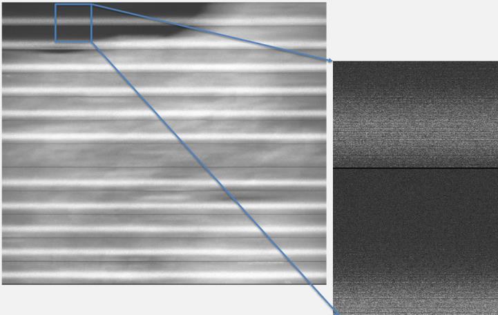
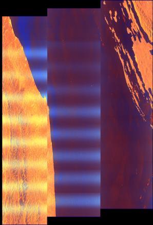
11 MPC-0432 DI-MPC-ARC V ,Dec.04 6 IW1 VH IW2 VH
:")


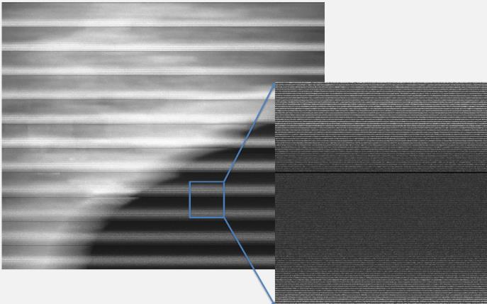
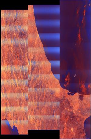
12 MPC-0432 DI-MPC-ARC V ,Dec.04 7 IW3 VH Figure 5: S1-A RS-2 Mutual Interference over Italy (16th August 2015): L0 intensity (left) and full interference extent (right) The RS-2 ScanSAR wide VV polarisation image acquired at the same time as the above S1-A image is shown in Figure 6 and Figure 7. The interference from S1-A is less obvious than in S1-A imagery but is nevertheless visible (range position indicated by arrows). Figure 6: RS-2 S1-A Mutual Interference over Italy (16th August 2015)
.")
13 MPC-0432 DI-MPC-ARC V ,Dec.04 8 Figure 7: Detail of RS-2 S1-A Mutual Interference over Italy (16th August 2015) Another example from 3rd October 2015 is shown in Figure 8. These images were acquired 48 days after those shown above (i.e. 2 RS-2 cycles and 4 S1-A cycles later). As discussed in Section 2 the slight change in ascending node crossing times for both S1-A and RS-2 between 16th August and 3rd October leads to a slight difference in the geographical latitude of the interference.

14 MPC-0432 DI-MPC-ARC V ,Dec.04 9 S1-A

15 MPC-0432 DI-MPC-ARC V ,Dec RS-2 Figure 8: S1-A RS-2 Mutual Interference from 3rd October 2015 over northern Italy/Switzerland A more recent example of S1-A mutual interference is shown in Figure 9 over Kazakhstan/China on 5th February at 00:13 to 00:14 UT. This also shows the track of S1-A and RS-2 as viewed from the town of Altay, China which is located within the interference (tracks obtained from RD-2) the position of the two tracks are very similar as is the time indicating the source of the interference is indeed RS-2. The final example is the only mutual interference with S1-B identified at the MPC Coordination Centre see Figure 10.

 and RS-2 (bottom")
16 MPC-0432 DI-MPC-ARC V ,Dec S1-A RS-2 Figure 9: S1-A RS-2 Mutual Interference from 5th February 2017 (top) and track of S1-A (bottom left) and RS-2 (bottom right) as viewed from Altay, China.

17 MPC-0432 DI-MPC-ARC V ,Dec S1B_IW_SLC 1ADV_ T100010_ T100036_005432_00985E_FAE9.SAFE Figure 10: S1-B RS-2 Mutual Interference from 3rd May 2017 Table 2 and Table 3 give the full list of mutual S1 and RS-2 interferences identified at the MPC Coordination Centre. The following is noted: All the S1-A cases are in the northern hemisphere whereas the only S1-B case is in the southern hemisphere. The first S1-A case occurred over 12 months after S1-A launch. The first cases were from ascending passes, whereas the more recent cases are from descending passes. The latitude of the S1-A cases were increasing up to late 2016 whereas since then the latitude has been decreasing. There is a wide spread of longitudes for which S1-A cases have occurred.
18 MPC-0432 DI-MPC-ARC V ,Dec Satellite Orbit Relative Orbit Acquisition Date Start Time (UT) End Time (UT) Approx. Latitude Approx. Location S1-A th August :55 16:58 43 N Italy S1-A th September :57 16:58 46 N Italy/Austria S1-A rd October :58 16:58 48 N Italy/Austria S1-A th October :56 17:00 51 N Germany S1-A th November :59 17:00 52 N Germany S1-A th December :19 03:20 60 N Alaska S1-A th January :56 17:04 62 N Sweden S1-A st January :58 17:04 62 N Sweden S1-A th February :03 17:04 63 N Norway S1-A * 3rd August :40 20:41 73 N NE Russia S1-A * 24th August :24 10:24 70 N Greenland S1-A * 17th September :22 10:24 74 N Greenland S1-A * 27th September :10 04:11 53 N Belarus/Russia S1-A * 11th October :22 10:26 74 N Greenland S1-A * 5th January :38 03:39 50 N Ukraine/Russia S1-A * 5th February :13 00:14 47 N Kazakhstan/China S1-A * 15th February :05 07:05 48 N North Atlantic S1-A * 1st March :14 00:16 40 N China S1-A * 18th March :42 03:43 34 N Cyprus S1-A * 21st March :59 14:00 36 N US West Coast S1-A * 25th March :15 00:17 36 N North China S1-A st March :51 20:52 36 N Japan S1-A * 18th April :17 00:18 30 N China S1-A * 12th May :19 00:20 25 N North India S1-A * 5th June :21 00:22 20 N India Table 2: List of S1-A Data with S1/RS2 Mutual Interference * Descending Pass
19 MPC-0432 DI-MPC-ARC V ,Dec Satellite Orbit Relative Orbit Acquisition Date Start Time (UT) End Time (UT) Approx. Latitude Approx. Location S1-B * 3rd May :00 10:01 20 S Bolivia * Descending Pass Table 3: List of S1-B Data with S1/RS2 Mutual Interference
 C-Band SAR satellite.")
20 MPC-0432 DI-MPC-ARC V ,Dec Sentinel-1 and Gaofen-3 One example of mutual interference has been identified between Sentinel1-A and the Chinese GAOFEN 3 (NORAD ID 41727) C-Band SAR satellite. Table 4 gives the orbital characteristics of S1 and GAOFEN 3. As for Radarsat-2, GAOFEN is in a higher orbit than S1 and in a dusk-dawn orbit. Sentinel-1 GAOFEN 3 Orbit Type Sun-Synchronous Sun-Synchronous Repeat Cycle (days) Repeat Cycle (orbits) * Altitude ~693 km ~751 km Orbital Period s 5980 s* Orbital Inclination MLST ~18:00 hrs ~18:00 hrs Table 4: Sentinel-1 and GAOFEN 3 Orbit Characteristics *deduced values The long duration interference occurred over China between 11:14 and 11:20 UT on 10th October 2018 as can be seen in Figure 11 with in more detail shown in Figure 12 (including the location of the town of Liangshan, China). Figure 13 shows the track of S1-A and GAOFEN 3 as viewed from Liangshan which is located within the interference the position of the two satellite tracks in the night sky as viewed from Liangshan are very similar as is the time indicating the source of the interference is indeed GAOFEN 3. Figure 11: S1-A GAOFEN 3 Mutual Interference from 10th October 2018

 Figure 13: The track of S1-A (left) and RS-2")
21 MPC-0432 DI-MPC-ARC V ,Dec Figure 12: Detail of S1-A GAOFEN 3 Mutual Interference from 10th October 2018 S1-A (time UT + 1 hour) GAOFEN 3 (time UT + 1 hour) Figure 13: The track of S1-A (left) and RS-2 (right) as viewed from Liangshan, China.

22 MPC-0432 DI-MPC-ARC V ,Dec Sentinel-1 and Unknown Satellite Further examples of long duration interference have been identified in S1-A imagery, but the source of the interference has yet to be identified. Given the duration of the interference, it is assumed that the source is another satellite C-Band SAR. Six occurrences have been found, five around the Gulf of Mexico/Florida/Cuba/Caribbean and one over Hawaii. All occurred at approximately the same latitude of 25 N. Table 5 gives the list of S1-A mutual with an unknown satellite while Figure 14 to Figure 22 shows interference itself. The timing between the various occurrences is quite irregular. Note that the appearance of the interference is very similar in all six examples and quite different from that caused by Radarsat-2 and Gaofen-3. Satellite Orbit Acquisition Date Date Take Start Time (UT) End Time (UT) Approx. Location S1-A th December & :27 23:30 Florida, USA S1-A th July D117 23:03 23:05 Caribbean S1-A th July D1C6 11:52 11:54 Mexico S1-A st October AE 11:18 11:23 Mexico/Cuba S1-A th November E3 & 0205E4 11:27 11:31 Mexico/Cuba S1-A th June B9E 16:31 16:33 Hawaii Table 5: Sentinel-1 and Unknown Satellite Mutual Interference Occurrences Figure 14: S1-A Mutual Interference from 8th December 2016


23 MPC-0432 DI-MPC-ARC V ,Dec Figure 15: Detail of S1-A Mutual Interference from 8th December 2016 Figure 16: S1-A Mutual Interference from 9th July 2017


24 MPC-0432 DI-MPC-ARC V ,Dec Figure 17: Detail of S1-A Mutual Interference from 9th July 2017 Figure 18: S1-A Mutual Interference from 11th July 2017


25 MPC-0432 DI-MPC-ARC V ,Dec Figure 19: Detail of S1-A Mutual Interference from 11th July 2017 Figure 20: S1-A Mutual Interference from 31st October 2017


26 MPC-0432 DI-MPC-ARC V ,Dec Figure 21: S1-A Mutual Interference from 5th November 2017 Figure 22: S1-A Mutual Interference from 14th June 2018
27 MPC-0432 DI-MPC-ARC V ,Dec Conclusions This report has described long duration mutual interference between Sentinel-1 and the Canadian Radarsat-2 satellite, the Chinese GAOFEN 3 satellite and an unknown satellite. Many S1-A and RS-2 interference examples are shown in imagery from both satellites. A full list of all known RS-2 interference in S1-A image has been provided (*). All known examples of interference with GAOFEN-3 and an unknown satellite are shown (*). (*) At the publication date of this report.
28 MPC-0432 DI-MPC-ARC V ,Dec Appendix A - List of acronyms MLST MPC RFI RS2 S1 Mean Local Solar Time Mission Performance Centre Radio Frequency Interference Radarsat-2 Sentinel-1
Impact of the Envisat Mission Extension on SAR data
 Impact of the Envisat Mission Extension on SAR data Impact of Envisat extension on SAR data Prepared by nuno miranda Reference Issue 0.9 Revision Date of Issue 23 August 2010 Status Preliminary version
Impact of the Envisat Mission Extension on SAR data
 Impact of the Envisat Mission Extension on SAR data Impact of Envisat Mission Extension on SAR data - 1.0 Prepared by Nuno Miranda, Berthyl Duesmann, Monserrat Pinol, Davide Giudici, Davide D Aria Reference
Sentinel and ESA Third-Party Mission data access and processing tools
 Sentinel and ESA Third-Party Mission data access and processing tools Magdalena Fitrzyk RSAC c/o ESA ESRIN 11/09/2018 Content Copernicus Sentinel missions Copernicus Open Access Hub: Sentinels Data Access
Validation Report: WP5000 Regional tidal correction (Noveltis)
") Consortium Members ESA Cryosat Plus for Oceans Validation Report: WP5000 Regional tidal correction (Noveltis) Reference: Nomenclature: CLS-DOS-NT-14-083 CP4O-WP5000-VR-03 Issue: 2. 0 Date: Jun. 20, 14
Consortium Members ESA Cryosat Plus for Oceans Validation Report: WP5000 Regional tidal correction (Noveltis) Reference: Nomenclature: CLS-DOS-NT-14-083 CP4O-WP5000-VR-03 Issue: 2. 0 Date: Jun. 20, 14
The Orbit Control of ERS-1 and ERS-2 for a Very Accurate Tandem Configuration
 The Orbit Control of ERS-1 and ERS-2 for a Very Accurate Tandem Configuration Mats Rosengren European Space Operations Centre Robert Bosch Str 5 D64293 Darmstadt Germany Email: mrosengr@esoc.esa.de Abstract
Sentinel-1 Mission Status
 Sentinel-1 Mission Status Pierre Potin, Sentinel-1 Mission Manager 5TH GEOGLAM RAPP Workshop 16-17 May 2017, ESRIN Sentinel-1: Copernicus radar imaging mission for ocean, land, emergency Part of the Copernicus
March 21. Observer located at 42 N. Horizon
 March 21 Sun Observer located at 42 N Horizon 48 June 21 March 21 A 48 90 S 23.5 S 0 23.5 N 42 N 90 N Equator (June 21) C (March 21) B A 71.5 48 Horizon 24.5 Observer Sun 40 Observer Sun 22 Observer Sun
Which Earth latitude receives the greatest intensity of insolation when Earth is at the position shown in the diagram? A) 0 B) 23 N C) 55 N D) 90 N
 0 B) 23 N C) 55 N D) 90 N") 1. In which list are the forms of electromagnetic energy arranged in order from longest to shortest wavelengths? A) gamma rays, x-rays, ultraviolet rays, visible light B) radio waves, infrared rays, visible
1. In which list are the forms of electromagnetic energy arranged in order from longest to shortest wavelengths? A) gamma rays, x-rays, ultraviolet rays, visible light B) radio waves, infrared rays, visible
Practice Questions: Seasons #1
 1. Seasonal changes on Earth are primarily caused by the A) parallelism of the Sun's axis as the Sun revolves around Earth B) changes in distance between Earth and the Sun C) elliptical shape of Earth's
ERS-2 and ENVISAT orbit control Current and future strategy The impact on the interferometric baseline
 ERS-2 and ENVISAT orbit control Current and future strategy The impact on the interferometric baseline Berthyl DUESMANN (ESA) & Itziar BARAT (ESA) Contributions by Nuno Miranda, Betlem Rosich, Montse Pinol,
Practice Seasons Moon Quiz
 1. Which diagram represents the tilt of Earth's axis relative to the Sun's rays on December 15? A) B) C) D) 2. The diagram below represents Earth in space on the first day of a season. 5. Base your answer
Orbit Design Marcelo Suárez. 6th Science Meeting; Seattle, WA, USA July 2010
 Orbit Design Marcelo Suárez Orbit Design Requirements The following Science Requirements provided drivers for Orbit Design: Global Coverage: the entire extent (100%) of the ice-free ocean surface to at
C) the seasonal changes in constellations viewed in the night sky D) The duration of insolation will increase and the temperature will increase.
 the seasonal changes in constellations viewed in the night sky D) The duration of insolation will increase and the temperature will increase.") 1. Which event is a direct result of Earth's revolution? A) the apparent deflection of winds B) the changing of the Moon phases C) the seasonal changes in constellations viewed in the night sky D) the
1. Which event is a direct result of Earth's revolution? A) the apparent deflection of winds B) the changing of the Moon phases C) the seasonal changes in constellations viewed in the night sky D) the
Introduction To Modern Astronomy I: Solar System
 ASTR 111 003 Fall 2007 Lecture 02 Sep. 10, 2007 Introduction To Modern Astronomy I: Solar System Introducing Astronomy (chap. 1-6) Planets and Moons (chap. 7-15) Chap. 16: Our Sun Chap. 28: Search for
Opportunities for advanced Remote Sensing; an outsider s perspective
 Opportunities for advanced Remote Sensing; an outsider s perspective Ramon Hanssen Delft University of Technology 1 Starting questions Can we do more with the data we are already acquire? What s in stock
drinking straw, protractor, string, and rock. observer on Earth. Sun across the sky on March 21 as seen by an
 1. The diagram below represents some constellations and one position of Earth in its orbit around the Sun. These constellations are visible to an observer on Earth at different times of the year. When
Geography Class 6 Chapters 3 and
 CHAPTER 3 MOTIONS OF THE EARTH The Earth is always travelling in Space. That makes each person on Earth, a Space Traveller. No one feels the movement of the Earth because humans are too tiny when compared
ANALYSIS OF THE MEGHA-TROPIQUES TRAJECTORY. DETERMINATION OF RENDEZ-VOUS CONDITIONS WITH THE TERRA SATELLITE.
 ANALYSIS OF THE MEGHA-TROPIQUES TRAJECTORY. DETERMINATION OF RENDEZ-VOUS CONDITIONS WITH THE TERRA SATELLITE. Michel Capderou (1), Florent Deleflie (2), and Olivier Chomette (1) (1) LMD-IPSL Ecole Polytechnique,
Orbits for Polar Applications Malcolm Macdonald
 Orbits for Polar Applications Malcolm Macdonald www.strath.ac.uk/mae 25 June 2013 malcolm.macdonald.102@strath.ac.uk Slide 1 Image Credit: ESA Overview Where do we currently put spacecraft? Where else
ERBE Geographic Scene and Monthly Snow Data
 NASA Contractor Report 4773 ERBE Geographic Scene and Monthly Snow Data Lisa H. Coleman, Beth T. Flug, Shalini Gupta, Edward A. Kizer, and John L. Robbins Science Applications International Corporation
Simulated Radiances for OMI
 Simulated Radiances for OMI document: KNMI-OMI-2000-004 version: 1.0 date: 11 February 2000 author: J.P. Veefkind approved: G.H.J. van den Oord checked: J. de Haan Index 0. Abstract 1. Introduction 2.
Sentinel-1A SAR Interferometry Verification
 Sentinel-1A SAR Interferometry Verification Dirk Geudtner1, Pau Prats2, Nestor Yaguee-Martinez2, Andrea Monti Guarnieri3, Itziar Barat1, Björn Rommen1 and Ramón Torres1 1ESA ESTEC 2DLR, Microwave and Radar
Earth Moon Motions A B1
 Earth Moon Motions A B1 1. The Coriolis effect provides evidence that Earth (1) rotates on its axis (2) revolves around the Sun (3) undergoes cyclic tidal changes (4) has a slightly eccentric orbit 9.
IOVWST Meeting, Sapporo/Japan, May 2016
 IOVWST Meeting, Sapporo/Japan, May 2016 The Design and Performance of the SCA Radar carried by the METOP Second Generation Satellites J. J. W. Wilson, C. Anderson EUMETSAT, Darmstadt, Germany. A. Ostergaard,
No End of Push-broom Operations
 Page 1 of 5 ESA Science & Technology 06-Mar-2006 17:30:17 No. 46 - End of Push-broom Operations 23 Dec 2005 Report for period 21 November to 18 December 2005 Smart-1 push-broom operations have continued
Using Solar Active Region Latitude Analysis to Monitor Solar Cycle Progress
 Using Solar Active Region Latitude Analysis to Monitor Solar Cycle Progress A Study Commissioned by RyeBrook Space Science Services RyeBrook Space 2017 Abstract: This paper seeks to answer the question
Usage of IGS TEC Maps to explain RF Link Degradations by Spread-F, observed on Cluster and other ESA Spacecraft
 Usage of IGS TEC Maps to explain RF Link Degradations by Spread-F, observed on Cluster and other ESA Spacecraft J. Feltens, J. Dow, G. Billig, D. Fornarelli, S. Pallaschke, B. Smeds, H.-J. Volpp, P. Escoubet,
An Update on EUMETSAT Programmes and Plans. Dieter Klaes on behalf of EUMETSAT teams
 An Update on EUMETSAT Programmes and Plans Dieter Klaes on behalf of EUMETSAT teams 1 21 st International TOVS Study Conference (ITSC), Darmstadt, Germany, 29 November 2017 5 December 2017 Current EUMETSAT
Mirrors in Space for Low-Cost Terrestrial Solar Electric Power at Night (Less than 6 cents per kwh) Dr Lewis Fraas JX Crystals Inc July 2012
 Dr Lewis Fraas JX Crystals Inc July 2012") Mirrors in Space for Low-Cost Terrestrial Solar Electric Power at Night (Less than 6 cents per kwh) Dr Lewis Fraas JX Crystals Inc July 2012 Space & Terrestrial Solar Cost Convergence Convergence 1500
Mirrors in Space for Low-Cost Terrestrial Solar Electric Power at Night (Less than 6 cents per kwh) Dr Lewis Fraas JX Crystals Inc July 2012 Space & Terrestrial Solar Cost Convergence Convergence 1500
ACHIEVING THE ERS-2 ENVISAT INTER-SATELLITE INTERFEROMETRY TANDEM CONSTELLATION.
 ACHIEVING THE ERS-2 ENVISAT INTER-SATELLITE INTERFEROMETRY TANDEM CONSTELLATION M. A. Martín Serrano (1), M. A. García Matatoros (2), M. E. Engdahl (3) (1) VCS-SciSys at ESA/ESOC, Robert-Bosch-Strasse
Current Status of the ALOS-2 Operation and PALSAR-2 Calibration Activities
 Current Status of the ALOS-2 Operation and PALSAR-2 Calibration Activities Takeshi Motohka, Ryo Natsuaki, Yukihiro Kankaku, Shinichi Suzuki, Masanobu Shimada (JAXA) Osamu Isoguchi (RESTEC) CEOS SAR CALVAL
AIR FORCE INSTITUTE OF TECHNOLOGY
 OPTIMAL ORBITAL COVERAGE OF THEATER OPERATIONS AND TARGETS THESIS Kimberly A. Sugrue, Captain, USAF AFIT/GA/ENY/07-M17 DEPARTMENT OF THE AIR FORCE AIR UNIVERSITY AIR FORCE INSTITUTE OF TECHNOLOGY Wright-Patterson
Orbit and Transmit Characteristics of the CloudSat Cloud Profiling Radar (CPR) JPL Document No. D-29695
 JPL Document No. D-29695") Orbit and Transmit Characteristics of the CloudSat Cloud Profiling Radar (CPR) JPL Document No. D-29695 Jet Propulsion Laboratory California Institute of Technology Pasadena, CA 91109 26 July 2004 Revised
Orbit and Transmit Characteristics of the CloudSat Cloud Profiling Radar (CPR) JPL Document No. D-29695 Jet Propulsion Laboratory California Institute of Technology Pasadena, CA 91109 26 July 2004 Revised
1.4j interpret simple shadow stick data to determine local noon and observer s longitude
 1.4j interpret simple shadow stick data to determine local noon and observer s longitude There are many opportunities for making observations of shadows cast with a vertical stick and the Sun. Observations
Which graph best shows the relationship between intensity of insolation and position on the Earth's surface? A) B) C) D)
 B) C) D)") 1. The hottest climates on Earth are located near the Equator because this region A) is usually closest to the Sun B) reflects the greatest amount of insolation C) receives the most hours of daylight D)
1. The hottest climates on Earth are located near the Equator because this region A) is usually closest to the Sun B) reflects the greatest amount of insolation C) receives the most hours of daylight D)
Julia Figa-Saldaña & Klaus Scipal
 Julia Figa-Saldaña & Klaus Scipal julia.figa@eumetsat.int klaus.scipal@esa.int Meeting, Outline MetOp/EPS status MetOp/EPS Second Generation status 2016 scatterometer conference Other European ocean programme
EUMETSAT STATUS AND PLANS
 1 EUM/TSS/VWG/15/826793 07/10/2015 EUMETSAT STATUS AND PLANS François Montagner, Marine Applications Manager, EUMETSAT WMO Polar Space Task Group 5 5-7 October 2015, DLR, Oberpfaffenhofen PSTG Strategic
LAB 2: Earth Sun Relations
 LAB 2: Earth Sun Relations Name School The amount of solar energy striking the Earth s atmosphere is not uniform; distances, angles and seasons play a dominant role on this distribution of radiation. Needless
ASCAT - Metop A developments, Metop B preparations & EPS-SG
 ASCAT - Metop A developments, Metop B preparations & EPS-SG Hans Bonekamp, Craig Anderson, Julia Figa & Julian Wilson Slide: 1 ASCAT Metop A - overview Instrument operating nominally (minor incident in
Motions of the Sun Model Exploration
 Name Date Bell Motions of the Sun Model Exploration 1. Go to the University of Nebraska-Lincoln Motions of the Sun Simulator: http://astro.unl.edu/naap/motion3/animations/sunmotions.swf 2. This is what
L.O: EARTH'S 23.5 DEGREE TILT ON ITS AXIS GIVES EARTH ITS SEASONS March 21 (SPRING), June 21(SUMMER), Sept 22 (AUTUMN) & Dec 21(WINTER)
, June 21(SUMMER), Sept 22 (AUTUMN) & Dec 21(WINTER)") L.O: EARTH'S 23.5 DEGREE TILT ON ITS AXIS GIVES EARTH ITS SEASONS March 21 (SPRING), June 21(SUMMER), Sept 22 (AUTUMN) & Dec 21(WINTER) 1. The apparent daily path of the Sun changes with the seasons because
L.O: EARTH'S 23.5 DEGREE TILT ON ITS AXIS GIVES EARTH ITS SEASONS March 21 (SPRING), June 21(SUMMER), Sept 22 (AUTUMN) & Dec 21(WINTER) 1. The apparent daily path of the Sun changes with the seasons because
EUMETSAT Satellite Status
 EUMETSAT Satellite Status Dr. K. Dieter Klaes EUMETSAT 1 ET-SAT Meeting 4-6 April 2017, WMO, Geneva, Switzerland EUMETSAT is an intergovernmental organisation with 30 Member States and 1 Cooperating State
Training Course on Radar & Optical RS, IES, Cēsis, Latvia, 5-9 September SAR Marine Applications. Wind and Waves
 SAR Marine Applications Wind and Waves Martin Gade Uni Hamburg, Institut für Meereskunde martin.gade@uni-hamburg.de SAR Marine Applications Friday, 9 Sep, Morning: 1 - History & Basics Introduction Radar/SAR
2. Descriptive Astronomy ( Astronomy Without a Telescope )
") How do we locate stars in the heavens? 2. Descriptive Astronomy ( Astronomy Without a Telescope ) What stars are visible from a given location? Where is the sun in the sky at any given time? Where are
How do we locate stars in the heavens? 2. Descriptive Astronomy ( Astronomy Without a Telescope ) What stars are visible from a given location? Where is the sun in the sky at any given time? Where are
5. In which diagram is the observer experiencing the greatest intensity of insolation? A) B)
 B)") 1. Which factor has the greatest influence on the number of daylight hours that a particular Earth surface location receives? A) longitude B) latitude C) diameter of Earth D) distance from the Sun 2. In
1. Which factor has the greatest influence on the number of daylight hours that a particular Earth surface location receives? A) longitude B) latitude C) diameter of Earth D) distance from the Sun 2. In
Satellite Constellations for Altimetry
 Satellite Constellations for Altimetry By Alain Lamy 1) and Josiane Costeraste 1) 1) CNES - Centre National d'etudes Spatiales, Toulouse, France The framework of the analysis presented in this paper is
MiSP Astronomy - Seasons Worksheet #1 L2
 MiSP Astronomy - Seasons Worksheet #1 L2 Name Date Changing Hours of Daylight on Long Island (L 1, 2, 3) Introduction You sometimes hear people say, Days are longer in the summer and shorter in the winter.
PHAS 1511: Foundations of Astronomy
 PHAS 1511: Foundations of Astronomy Dr Roger Wesson Research interests: deaths of stars. Planetary nebulae, novae and supernovae. Astronomy: some maths You can see that distances in astronomy are huge.
ALOS-2 Basic Observation Scenario (First Edition) January 10, 2014 JAXA/ALOS-2 Project
 January 10, 2014 JAXA/ALOS-2 Project") ALOS-2 Basic Observation Scenario (First Edition) January 10, 2014 JAXA/ALOS-2 Project 1 1.First edition 2.Purpose and Background 3.Approach of the Basic Observation Scenario 4.Basic Observation
ALOS-2 Basic Observation Scenario (First Edition) January 10, 2014 JAXA/ALOS-2 Project 1 1.First edition 2.Purpose and Background 3.Approach of the Basic Observation Scenario 4.Basic Observation
SENTINEL 1 Mission status and contribution to PSTG
 PSTG SAR WG meeting, 12 September 2016, ESTEC SENTINEL 1 Mission status and contribution to PSTG First Sentinel1B Images 28 April 2016 Sentinel-1B Launch from Kourou, 25 April 2016 Sentinel 1 Mission Operations
Meteorology. Circle the letter that corresponds to the correct answer
 Chapter 3 Worksheet 1 Meteorology Name: Circle the letter that corresponds to the correct answer 1) If the maximum temperature for a particular day is 26 C and the minimum temperature is 14 C, the daily
Summer solstice June 21, 2014
 function get_style19370 () { return "none"; } function end19370_ () { document.getelementbyid('elastomer19370').style.display = get_style19370(); } Differences in amount of daylight on solstices for Liberal
MiSP Astronomy Seasons Worksheet #1 L1
 MiSP Astronomy Seasons Worksheet #1 L1 Name Date CHANGING HOURS OF DAYLIGHT ON LONG ISLAND Introduction You sometimes hear people say, Days are longer in the summer and shorter in the winter. That is a
ALOS-2 Basic Observation Scenario (First Edition) October 10, 2014 JAXA/ALOS-2 Project
 October 10, 2014 JAXA/ALOS-2 Project") ALOS-2 Basic Observation Scenario (First Edition) October 10, 2014 JAXA/ALOS-2 Project 1 Revision details Rev. Date Page Revision details A October 10, 2014 P13,P30 P17 Updated the date of Basic Observation
ALOS-2 Basic Observation Scenario (First Edition) October 10, 2014 JAXA/ALOS-2 Project 1 Revision details Rev. Date Page Revision details A October 10, 2014 P13,P30 P17 Updated the date of Basic Observation
Fundamentals of Satellite technology
 Fundamentals of Satellite technology Prepared by A.Kaviyarasu Assistant Professor Department of Aerospace Engineering Madras Institute Of Technology Chromepet, Chennai Orbital Plane All of the planets,
HY-2A Satellite User s Guide
 National Satellite Ocean Application Service 2013-5-16 Document Change Record Revision Date Changed Pages/Paragraphs Edit Description i Contents 1 Introduction to HY-2 Satellite... 1 2 HY-2 satellite data
Laboratory Exercise #7 - Introduction to Atmospheric Science: The Seasons
 Laboratory Exercise #7 - Introduction to Atmospheric Science: The Seasons page - 1 Section A - Introduction: This lab consists of both computer-based and noncomputer-based questions dealing with atmospheric
Megha-Tropiques Presentation by Indian Delegation at the 55th Session of UNCOPUOS Vienna 12 June 2012
 Megha-Tropiques Presentation by Indian Delegation at the 55 th Session of UNCOPUOS Vienna 12 June 2012 Megha-Tropiques Mission Indo-French Joint Satellite for studying tropical atmosphere Megha in Sanskrit
Chapter 1: Discovering the Night Sky. The sky is divided into 88 unequal areas that we call constellations.
 Chapter 1: Discovering the Night Sky Constellations: Recognizable patterns of the brighter stars that have been derived from ancient legends. Different cultures have associated the patterns with their
2 Preliminary Results Achieved by the Meridian Project
 Space Science Activities in China cycle peak year ( ), magnetic storm activities increased significantly, the Meridian Project has repeatedly observed the responses of the space environment to solar storms
Updates on CMA FENGYUN Meteorological Satellite Programs
 Updates on CMA FENGYUN Meteorological Satellite Programs Peng ZHANG National Satellite Meteorological Center, China Meteorological Administration (NSMC/CMA) 29 Nov. - 5 Dec. 2017, Darmstadt, Germany 1.
Longest TOTAL LUNAR ECLIPSE observe from AGARTALA, TRIPURA. July 27-28, 2018
 Longest TOTAL LUNAR ECLIPSE observe from AGARTALA, TRIPURA July 27-28, 2018 Path of Longest Total Lunar Eclipse through Shadow of Earth Prepared By Shri Bipash Das Gupta, Scientific Officer M.P. Birla
CELESTIAL COORDINATES
 ASTR 1030 Astronomy Lab 27 Celestial Coordinates CELESTIAL COORDINATES GEOGRAPHIC COORDINATES The Earth's geographic coordinate system is familiar to everyone - the north and south poles are defined by
Ice surveys, meteorological and oceanographic data What is available and up-to-date?
 Ice surveys, meteorological and oceanographic data What is available and up-to-date? Leader of the Norwegian Ice Service +47 77 62 13 15 - nick.hughes@met.no Norwegian Meteorological Institute met.no 1
NAVIGATION THEORY QUESTIONS Basics of Navigation
 NAVIGATION THEORY QUESTIONS Basics of Navigation Q610065 look at it The angle between the plane of the ecliptic and the plane of equator is approx? 23.5 degrees In which two months of the year is the difference
Admin. 8/29/17. If you re at North Pole, you ll NEVER see stars that are below your horizon. Key Concepts: Lecture 4
 Admin. 8/29/17 1. Class website http://www.astro.ufl.edu/~jt/teaching/ast1002/ 2. Optional Discussion sections (start Aug. 30th) (see me at end of lecture if you can t make one of these times)! Tuesday
Seasons Quiz Please Do Not Write on this Paper Obrigado
 Seasons Quiz Please Do Not Write on this Paper Obrigado Use this diagram of the sun and Earth's path around the sun to answer the next two questions. The N indicates North and Earth is traveling from A
A Survey of Spacecraft Charging Events on the DMSP Spacecraft in LEO
 A Survey of Spacecraft Charging Events on the DMSP Spacecraft in LEO Phillip C. Anderson Space Science Applications Laboratory The Aerospace Corporation PO Box 92957 M2/260 Los Angeles, CA 90009-2957 ph:
The celestial sphere, the coordinates system, seasons, phases of the moon and eclipses. Chapters 2 and S1
 The celestial sphere, the coordinates system, seasons, phases of the moon and eclipses Chapters 2 and S1 The celestial sphere and the coordinates system Chapter S1 How to find our way in the sky? Let s
function get_style23731 () { return "none"; } function end23731_ () { document.getelementbyid('elastomer23731').style.display = get_style23731(); }
 { return none; } function end23731_ () { document.getelementbyid('elastomer23731').style.display = get_style23731(); }") function get_style23731 () { return "none"; } function end23731_ () { document.getelementbyid('elastomer23731').style.display = get_style23731(); } EarthSky Late dawn. Early sunset. Short day. Long night.
function get_style23731 () { return "none"; } function end23731_ () { document.getelementbyid('elastomer23731').style.display = get_style23731(); } EarthSky Late dawn. Early sunset. Short day. Long night.
NATIONAL UNIVERSITY OF SINGAPORE DEPARTMENT OF MATHEMATICS SEMESTER 2 EXAMINATION Heavenly Mathematics: Cultural Astronomy
 1 GEK1506 NATIONAL UNIVERSITY OF SINGAPORE DEPARTMENT OF MATHEMATICS SEMESTER 2 EXAMINATION 2005 2006 GEK1506 Heavenly Mathematics: Cultural Astronomy April/May 2006 Time allowed: 2 hours 1. After taking
Geographic Grid -Latitudes and Longitudes
 GEOGRAPHY STD 9 Geographic Grid -Latitudes and Longitudes 2018-2019 Q1. Define Geographic Grid. The network of latitudes and longitudes are known as Geographic Grid. They help us to locate places on the
Practice Questions: Seasons #2
 1. How many degrees does the Sun appear to move across the sky in four hours? A) 60 B) 45 C) 15 D) 4 Practice Questions: Seasons #2 2. Base your answer to the following question on the diagram below, which
Global Temperature Report: December 2018
 Jan 2, 2019 Vol. 28, No. 9 For Additional Information: Dr. John Christy, (256) 961-7763 christy@nsstc.uah.edu Dr. Roy Spencer, (256) 961-7960 spencer@nsstc.uah.edu Global Temperature Report: December 2018
Coordinates on the Sphere
 Survey Observations Coordinates on the Sphere Any position on the surface of a sphere (such as the Earth or the night sky) can be expressed in terms of the angular coordinates latitude and longitude Latitude
Calculations Equation of Time. EQUATION OF TIME = apparent solar time - mean solar time
 Calculations Equation of Time APPARENT SOLAR TIME is the time that is shown on sundials. A MEAN SOLAR DAY is a constant 24 hours every day of the year. Apparent solar days are measured from noon one day
Exercise 2: The UW planetarium
 Astronomy 100, Fall 2008 Name(s): Exercise 2: The UW planetarium The University of Washington Physics and Astronomy Building houses a wonderful planetarium, in addition to some other interesting displays.
SAR Coordination for Snow Products
 Polar SAR Coordination Working Meeting 5 SAR Coordination for Snow Products David Small 1, Thomas Nagler 2, David Jäger 1, Christoph Rohner 1, Adrian Schubert 1 1: University of Zurich, Switzerland 2:
GEO Joint Experiment for Crop Assessment and Monitoring (JECAM): 2014 Site Progress Report
: 2014 Site Progress Report") GEO Joint Experiment for Crop Assessment and Monitoring (JECAM): JECAM Test Site Name: China - Guangdong 2014 Site Progress Report Team Leader and Members: Prof Wu Bingfang (Leader), Jiratiwan Kruasilp,
GEO Joint Experiment for Crop Assessment and Monitoring (JECAM): JECAM Test Site Name: China - Guangdong 2014 Site Progress Report Team Leader and Members: Prof Wu Bingfang (Leader), Jiratiwan Kruasilp,
Long term performance monitoring of ASCAT-A
 Long term performance monitoring of ASCAT-A Craig Anderson and Julia Figa-Saldaña EUMETSAT, Eumetsat Allee 1, 64295 Darmstadt, Germany. Abstract The Advanced Scatterometer (ASCAT) on the METOP series of
CHAPTER 2 A USER'S GUIDE TO THE SKY
 CHAPTER 2 A USER'S GUIDE TO THE SKY MULTIPLE CHOICE 1. Seen from the northern latitudes (mid-northern hemisphere), the star Polaris a. is never above the horizon during the day. b. always sets directly
CloudSat Data Processing Center (DPC)
") CloudSat Data Processing Center (DPC) CloudSat Data Processing and R05 Processing Plan CloudSat Data Processing Center Overview 1 C l o u d S a t: Data Capture Stats The USAF has collected 99.97% of all
CloudSat Data Processing Center (DPC) CloudSat Data Processing and R05 Processing Plan CloudSat Data Processing Center Overview 1 C l o u d S a t: Data Capture Stats The USAF has collected 99.97% of all
Exercise 6. Solar Panel Orientation EXERCISE OBJECTIVE DISCUSSION OUTLINE. Introduction to the importance of solar panel orientation DISCUSSION
 Exercise 6 Solar Panel Orientation EXERCISE OBJECTIVE When you have completed this exercise, you will understand how the solar illumination at any location on Earth varies over the course of a year. You
The DEIMOS Earth Observation System and the PanGeo Alliance. Contribution to CSCDA Data WareHouse 2. Fabrizio Pirondini CEO, Elecnor Deimos Imaging
 The DEIMOS Earth Observation System and the PanGeo Alliance Contribution to CSCDA Data WareHouse 2 Fabrizio Pirondini CEO, Elecnor Deimos Imaging Copernicus Space Component Data Access Workshop ESRIN,
GROUNDBASED FTIR, OZONESONDE AND LIDAR MEASUREMENTS FOR THE VALIDATION OF SCIAMACHY (AOID 331)
") GROUNDBASED FTIR, OZONESONDE AND LIDAR MEASUREMENTS FOR THE VALIDATION OF SCIAMACHY (AOID 331) Astrid Schulz (1), Thorsten Warneke (2), Justus Notholt (2), Otto Schrems (1), Roland Neuber (1), Peter von
GROUNDBASED FTIR, OZONESONDE AND LIDAR MEASUREMENTS FOR THE VALIDATION OF SCIAMACHY (AOID 331) Astrid Schulz (1), Thorsten Warneke (2), Justus Notholt (2), Otto Schrems (1), Roland Neuber (1), Peter von
Status report on current and future satellite systems by EUMETSAT Presented to CGMS-44, Plenary session, agenda item D.1
 Status report on current and future satellite systems by EUMETSAT Presented to CGMS-44, Plenary session, agenda item D.1 CGMS-44-EUMETSAT-WP-19.ppt, version 1 (# 859110), 8 June 2016 MISSION PLANNING YEAR...
Sentinel-1 Mission Overview
 Sentinel-1 Mission Overview N. Miranda, ESA S-1 Space Project Team S-1 PDGS Team PolinSAR 2013 Info day Outline Mission objectives S-1 Acquisition Modes S-1 Piloting Modes S-1 Product Family S-1 Product
Space! Science Year 5/6B Autumn 2. Earth and Space. Session 2. Resource Pack
 Science Year 5/6B Autumn 2 Earth and Space Space! Session 2 Resource Pack Original resource copyright Hamilton Trust, who give permission for it to be adapted as wished by individual users. We refer you
A two-season impact study of the Navy s WindSat surface wind retrievals in the NCEP global data assimilation system
 A two-season impact study of the Navy s WindSat surface wind retrievals in the NCEP global data assimilation system Li Bi James Jung John Le Marshall 16 April 2008 Outline WindSat overview and working
Lab Activity: Climate Variables
 Name: Date: Period: Water and Climate The Physical Setting: Earth Science Lab Activity: Climate Variables INTRODUCTION:! The state of the atmosphere continually changes over time in response to the uneven
Figure 1. View of ALSAT-2A spacecraft
 ALSAT-2A TRANSFER AND FIRST YEAR OPERATIONS M. Kameche (1), A.H. Gicquel (2), D. Joalland (3) (1) CTS/ASAL, 1 Avenue de la Palestine, BP 13, Arzew 31200 Oran, Algérie, email:mo_kameche@netcourrier.com
TEMPORAL VARIABILITY OF ICE FLOW ON HOFSJÖKULL, ICELAND, OBSERVED BY ERS SAR INTERFEROMETRY
 TEMPORAL VARIABILITY OF ICE FLOW ON HOFSJÖKULL, ICELAND, OBSERVED BY ERS SAR INTERFEROMETRY Florian Müller (1), Helmut Rott (2) (1) ENVEO IT, Environmental Earth Observation GmbH, Technikerstrasse 21a,
Phys Lab #1: The Sun and the Constellations
 Phys 10293 Lab #1: The Sun and the Constellations Introduction Astronomers use a coordinate system that is fixed to Earth s latitude and longitude. This way, the coordinates of a star or planet are the
Meridian Circle through Zenith, North Celestial Pole, Zenith Direction Straight Up from Observer. South Celestial Pole
 Chapter 3 How Earth and Sky Work- Effects of Latitude In chapters 3 and 4we will learn why our view of the heavens depends on our position on the Earth, the time of day, and the day of the year. We will
Floating Ice: Progress in Addressing Science Goals
 Polar Floating Ice: Progress in Addressing Science Goals Stephen Howell 1, Leif Toudal Pedersen 2 and Roberto Saldo 3 1 Environment Canada, Climate Research Division, Toronto, Canada 2 Danish Meteorological
The Moon. It's Just a Phase It's Going Through...
 The Moon It's Just a Phase It's Going Through... www.thesciencequeen.net Moon Our planet's large natural satellite, the Moon, is the easiest astronomical object to observe. The only "scientific instrument"
The Launch of Gorizont 45 on the First Proton K /Breeze M
 The Launch of Gorizont 45 on the First Proton K / Fred D. Rosenberg, Ph.D. Space Control Conference 3 April 2001 FDR -01 1 This work is sponsored by the Air Force under Air Force Contract F19628-00-C-0002
Orbit Definition. Reference Vector. Vernal (March) Equinox Vector. Sun Vector
 Equinox Vector. Sun Vector") Simulation: TMG Thermal Analysis User's Guide Orbit Definition TMG can model three types of orbits: Beta Angle, Geostationary and Classical. For Earth, three special classical orbits are already partially
Simulation: TMG Thermal Analysis User's Guide Orbit Definition TMG can model three types of orbits: Beta Angle, Geostationary and Classical. For Earth, three special classical orbits are already partially
Ice & Snow Session. Chairs: J. Mouginot & N. Gourmelen
 Ice & Snow Session Chairs: J. Mouginot & N. Gourmelen Session 12 talks and 10 posters Antarctic ice motion, ground-line detection and monitoring, dynamics ice-fluctuations in Antarctica and Greenland,
Earth Science Seasons Test Name Per Date
 Name Per Date Page 1 1. The diagram below represents four positions of the Earth as it revolves around the Sun. 5. Base your answer to the following question on the diagram below, which shows the apparent