Landslide Characteristics and Observations
|
|
|
- Tyler Stokes
- 6 years ago
- Views:
Transcription
1 Landslide Characteristics and Observations Lecture at the Summer School Alpbach 2006 by Helmut Rott Dept. of Meteorology & Geophysics, Univ. of Innsbruck & ENVEO IT GmbH, Innsbruck AUSTRIA Contents of Lecture Overview of landslide types and characteristics Factors for slope stability Overview of in situ observation methods Landslide mapping by optical sensors Satellite-borne interferometric SAR (InSAR) for slope deformation, applications examples in mountains and inhabited areas InSAR application for landslide susceptibility mapping Conclusion on satellite methods for landslide monitoring Aplbach_2006 H. Rott 1
 Major Landslide Types - 1 Source: USGS Aplbach_2006 H.")
2 Landslide Types Classification of Landslides according to type of material and movement. After Varnes (1978) Major Landslide Types - 1 Source: USGS Aplbach_2006 H. Rott 2


3 Major Landslide Types - 2 Source: USGS Landslide Type: Debris Avalanche Volume 80 x 10 6 m 3 Earthquake triggered Landslide - Pakistan Satellite Image: Digital Globe QuickBird II, 27 Oct 05 Source: USGS Report Aplbach_2006 H. Rott 3


4 Vajont Landslide Volume 270 x 10 6 m 3 D. Petley, Volcanoclastic Mudflow triggered by Intense Rain Sarno, Campania, 5 May 1998 Ref: NEDIS Report Aplbach_2006 H. Rott 4
5 Features observed in high resolution imagery: drainage patterns gully erosion marks transversal and radial cracks scarps transverse ridges changes in vegetation cover Landslide - Geomorphological Features Characterization of Landslides for Stability Assessment Failure surfaces (shape, roughness, defects) Surface topography (precision digital maps, morphology) Depositional area Type of movement Rate of movement Size and properties of material (structure, strength, friction angle) Age of failure Subsurface water level, pore pressure Trigger mechanisms Aplbach_2006 H. Rott 5

6 GEO-Information Tools for Landslide Risk Analysis Ref: Van Westen, 2004 Landslide Stability Analysis Equilibrium of Forces Normal stress across contact surface σ n = (W cosα)/a Shear strength on sliding surface τ = c + tanφ W cosα/a Resisting shear force R = τa = ca + W cosα tanφ Limiting block equilibrium condition (Mohr-Coulomb Criterion: Linear relationship between normal and shear stresses) W sin α = c + W cosα tanφ W block weight force A area of the block base c cohesion strength (stress) φ friction angle φ Key landslide triggering factors Changes of water level (intense rain; water level fluctuations of reservoirs) Excavation by construction activities and mining Deforestation, erosion Glacier and permafrost retreat Earthquakes Volcanic activities Aplbach_2006 H. Rott 6

7 Landslide Zonation Methods Source: LESSLOSS Landslide Exploration Techniques Surface Observations Mapping by airborne and spaceborne imagers: extent, morphology, topogr. Geologic field surveys: morphology, shape, roughness, structure, lithology Airborne laser scanning: precise topographic mapping Ground based geodesy (GPS etc.): surface displacement Ground-based SAR, GB laser scanner: surface displacement, topography Spaceborne SAR: surface displacement, topography Extensiometers: surface deformation Sub-surface Exploration Rock coring, test pits: material properties, characteristics of failure surface Refraction and reflection seismics: depth and characteristcis of discontinuities Ground penetrating radar (GPR); depth and type of discontinuity Electromagnetics, geoelectrics: subsurface discontinuities; ground water Inclinometers, tiltmeters, accelerometers in boreholes: Subsurface movements Time domain reflectometry TDR in borehole: depth of shear plane; water Aplbach_2006 H. Rott 7


,")

8 Example of Geophysical Exploration: Seismic Monitoring Atemkopf, Kaunertal Measurement Campaign Aug Microseisimic Stations Location of seismic events ISDR-IDNDR Project of ÖAW Project Lead: E. Brückl, TU Wien Ground-based InSAR for Continuous Monitoring Eiblschrofen near Schwaz LISA (Linear SAr), developed at IPSC-JRC Stepped frequency CW radar, 500 MHz - 18 GHz Aplbach_2006 H. Rott 8


9 LISA Measurements at Eiblschrofen Time period: 7 days Time period: 2 months LOS Displacement on slope Ku-band measurements in 2001 Landslide Monitoring by Optical Remote Sensing 28/09/1988 Tessina Landslide Belluno 7/10/1994 Ref: Hervas et al., 2003 Red: new soil outcrops Yellow; new vegetation growth Aplbach_2006 H. Rott 9


10 Mapping Small-Scale Earthflows Landsat-7 TM 13/09/1999 Band 4,3, 2 Gerlostal (Zillertal) Ikonos 15/08/2000 Band 4,3, 2 Resolution: 4 m Comparison of Techniques for Landslide Mapping Tsaoling Landslide, Taiwan A AIRSAR L-band polarimetry B C-band VV C Landsat 7 TM D IRS Pan (5 m) Ref: Czuchlewski et al., 2004 Aplbach_2006 H. Rott 10
 L-band SAR (λ = 25 cm): φ (2π) R = 12.")
11 Measurement of Surface Displacement by InSAR φ dis = (4π/λ) R = (4π/λ)( y sin θ - z cos θ) InSAR measures the displacement in LOS of the radar beam C-band SAR (λ = 5.66 cm): φ (2π) R = 2.83 cm y = 7.24 cm, z = 3.07 cm (23 ) L-band SAR (λ = 25 cm): φ (2π) R = cm (23 ) Requirement for DInSAR Processing: Coherence Coherence Image 1-year Time Spans Tyrolean Alps Degree of Coherence Aplbach_2006 H. Rott 11


12 Coherence in Alpine Area over Annual Intervals Data: ERS SAR, descending pass Basin Zillertal, Eastern Alps, 1618 km 2 Criteria: 15 θ 80 γ 0.3 Mass Waste above the Gepatsch Reservoir Aplbach_2006 H. Rott 12


13 The Unstable Slope above Gepatsch Reservoir Landsat-7 image 13/09/1999 View from the dam Aplbach_2006 H. Rott 13


14 SAR Amplitude Image in Radar Geometry One-Year Coherence c o h e r e n c e Aplbach_2006 H. Rott 14

15 Interferogram topo and motion phase 25/9/95-12/9/96 B n = -12m H a = 920 m Annual Surface Motion by ERS InSAR Displacement in mm/a with surface-parallel assumption Aplbach_2006 H. Rott 15


16 Profiles of Surface Motion, Integration of InSAR Motion Map with GIS Motion contours on Orthophoto Aplbach_2006 H. Rott 16

17 Modelling Displacement and Stability of the Mass Waste Gepatsch Objectives: - Interpretation of observed InSAR displacements - Simulations of conditions for failure Diagram: Setup with zones of base Gneiss, weak Gneiss and Moraine Arrows: Total displacement after reducing angle of inner friction Model Code: UDEC Universal Distinct Element Code, Itasca Inc. Ancona Landslide Analysis by Permanent Scatterers Radar Data: ESA ERS-1/2 Processing: POLIMI 1 2 Descent Front Ascent Front Aplbach_2006 H. Rott 17


18 Average Displacement Rate of Permanent Scatterers Jesi Chiaravalle Average LOS Displacement Rate Falconara Landslide Harbour Aspio Ancona [mm/yr] Analysis of Surface Displacement in Mountain Village Topographic Phase ERS Tandem Data Schellen berg Bodensee Walgau 14/13 Jan 1996 Bper = 89 m Ha = 110 m Triesen berg L F Aplbach_2006 H. Rott 18


19 One-year Coherence and Interferogram 1996 Jul Aug 31 blue green yellow Coherence Interferogram (incl. topographic phase contribution): B n = 31 m Slope Motion retrieved from Single SAR Image Pair >25mm/a <1mm/a N Triesenberg, Lichtenstein Interferometric motion 7 July Aug 1997 surface-parallel assumption (on Orthophoto ) Aplbach_2006 H. Rott 19


 RMSE")

20 DInSAR Slope Motion from Single Image Pair Triesenberg Comparison of one-year motion InSAR ) vs. GPS (mean ) RMSE = 3.5 mm/year Comparison GPS - Permanent Scatterer Motion Aplbach_2006 H. Rott 20


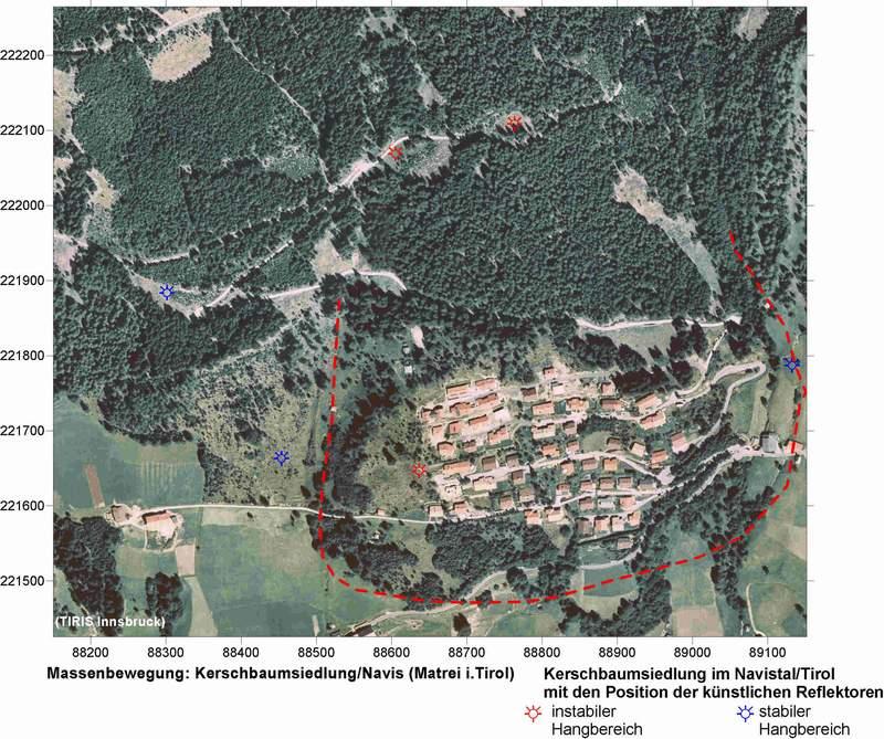
21 DinSAR Analysis in Forested Areas using Reflectors Multi-temporal Envisat ASAR image, IS2 VV Aplbach_2006 H. Rott 21


 Envisat ASAR")
22 Specular Reflectors 1 x 1 m 2 σ max = 35.9 dbm 2 for 5.3 GHz Reflector P4 Impulse Response of Reflector (Amplitude) Envisat ASAR IS2 VV Aplbach_2006 H. Rott 22


 in the Arno river")

")
23 Displacement of Reflectors Kerschbaumsiedlung, Navis ASAR IS2 VV SLCI slant range image Landslide Mapping at Regional Scale using InSAR Landslides (in red) in the Arno river basin (Umbria, Toscana) Superimposed to DEM Project SLAM Service for Landslide Monitoring (funded by ESA DUP) Aplbach_2006 H. Rott 23


24 SLAM - Landslide Displacement Monitoring SLAM - Landslide Susceptibility Mapping Aplbach_2006 H. Rott 24
 DEM Geomorphological maps Geology & soil properties Etc.")


25 SLAM - Landslide Susceptibility Map Arno Basin Data Base: InSAR (350 SAR images) DEM Geomorphological maps Geology & soil properties Etc. InSAR Applicability for Landslide Motion Monitoring InSAR: AE Area extended; PS Permanent Scatterer; GB Ground-Based Landslide Motion Monitoring Requirements INSAR Tools Resolution Motion range Accuracy Repeat interval Rapid slides ca. 50 m > 1 m/d 10 % of velocity 10 min 2 h GB Moderate motion ca. 50 m 0.5 m/a 1 m/d 0.1 m/a 0.1 m/d 1 20 d AE, GB Slow slides 50 m 100 m m/a m/a a PS, AE, GB Aplbach_2006 H. Rott 25
 can be detected and mapped by")
26 Satellite Capabilities for Landslide Monitoring Optical imagery and SAR amplitude images provide basic information on landslide areas and surface morphology useful for landslide zonation at regional scale InSAR provides very accurate information on LOS displacement of slopes, a very important indicator of slope stability Slope movements (on the order of mm/a to m/a) can be detected and mapped by means of satellite-borne SAR interferometry InSAR is an economic tool for regional landslide surveys and monitoring, but constraints related to vegetation, observation geometry and landslide type need to be taken into account 15 years of archived SAR data are useful to study temporal variations of motion, important for assessing slope stability, complementary to other information New SAR systems (in particular TanDEM-X) will acquire high resolution DEMs, key information for landslide characterization Needs for Ground Instability Information Source: IGOS Geohazards Report Aplbach_2006 H. Rott 26
27 References Czuchlewski K.R., Y. Kim and J.K. Weissel Assessing natural disaster impacts and recovery using multi-frequency, fully polarimetric SAR. Proc. POLinSAR 2005, Colesanti, C., Ferretti, A., Prati, C. et al Monitoring landslides and tectonic motions using the Permanent Scatterer Technique. Engineering Geology 86, IGOS Integrated Global Observing Strategy Geohazards Theme Report. Hervas J. et al Monitoring landslides form optical remotely sensed imagery: the case history of Tessina landslide, Italy. Geomorphology 54, Rott H., Scheuchl, B., Siegel, A et al. Monitoring very slow slope movements by means of SAR interferometry: a case study from a mass waste above a reservoir in the Ötztal Alps, Austria. Geophys. Res. Let., 26, Rott, H., Nagler, T., Rocca, F., et al MUSCL - Monitoring Urban Subsidence, Cavities and Landslides by remote sensing, Final Report, EC project EVG1-CT , Inst. for Meteorology and Geophysics, Univ. of Innsbruck, Austria. Rott, H. and T. Nagler. The Contribution of Radar Interferometry to the Assessment of Landslide Hazards. Adv. Space Research, 37, Strozzi, T., Wegmüller, U., Werner, C.L., et al., JERS SAR interferometry for land subsidence monitoring. IEEE Trans. Geosc. Rem. Sens,. 41(7), Van Westen, C.J Geo-information tools for landslide risk assessment. Proc. 9th Int. Symp. on Landslides, Balkema, pp Relevant Web Sites LESSLOSS - Risk Mitigation for Earthquakes and Landslides, EC-FP6, MUSCL - Monitoring urban subsidence, cavities and landslides by remote sensing, EC-FP5 EU-MEDIN - European Mediterranean Disaster Information Network. LEWIS - Landslide Early-Warning Integrated System, EC-FP-5, GLALAHAD - Advanced Remote Monitoring Techniques for Glaciers, Avalanches & Landslides Hazard Mitigation NEDIS Natural Environmental Disaster Information Exchange System, USGS Landslide Hazards Program, SLAM InSAR Conference Aplbach_2006 H. Rott 27
InSAR techniques and applications for monitoring landslides and subsidence
 Geoinformation for European-wide Integration, Benes (ed.) 2003 Millpress, Rotterdam, ISBN 90-77017-71-2 InSAR techniques and applications for monitoring landslides and subsidence H. Rott & T. Nagler Institut
DIFFERENTIAL INSAR STUDIES IN THE BOREAL FOREST ZONE IN FINLAND
 DIFFERENTIAL INSAR STUDIES IN THE BOREAL FOREST ZONE IN FINLAND Kirsi Karila (1,2), Mika Karjalainen (1), Juha Hyyppä (1) (1) Finnish Geodetic Institute, P.O. Box 15, FIN-02431 Masala, Finland, Email:
RADAR Remote Sensing Application Examples
 RADAR Remote Sensing Application Examples! All-weather capability: Microwave penetrates clouds! Construction of short-interval time series through cloud cover - crop-growth cycle! Roughness - Land cover,
VALIDATION OF THE PERMANENT SCATTERERS TECHNIQUE IN URBAN AREAS
 VALIDATION OF THE PERMANENT SCATTERERS TECHNIQUE IN URBAN AREAS Alessandro Ferretti, Claudio Prati, Fabio Rocca, Carlo Colesanti Dipartimento di Elettonica e Informazione Politecnico di Milano Piazza L.
TEMPORAL VARIABILITY OF ICE FLOW ON HOFSJÖKULL, ICELAND, OBSERVED BY ERS SAR INTERFEROMETRY
 TEMPORAL VARIABILITY OF ICE FLOW ON HOFSJÖKULL, ICELAND, OBSERVED BY ERS SAR INTERFEROMETRY Florian Müller (1), Helmut Rott (2) (1) ENVEO IT, Environmental Earth Observation GmbH, Technikerstrasse 21a,
GEO The Åknes rock slope. Content. Dr. Vidar Kveldsvik NGI
 GEO 4180 The Åknes rock slope Dr. Vidar Kveldsvik NGI Content Background on large rock slides Triggers Stability analysis Risk mitigation (risk reduction) The Åknes rock slope 1 Background Landslides due
Retrieving 3D deformation pattern of a landslide with hiresolution InSAR and in-situ measurements: Just landslide case-study
 Retrieving 3D deformation pattern of a landslide with hiresolution InSAR and in-situ measurements: Just landslide case-study Zbigniew Perski (1), Petar Marinković (2), Yngvar Larsen (3), Tomasz Wojciechowski
Dr. Simon Plank. German Remote Sensing Data Center (DFD), German Aerospace Center (DLR)
, German Aerospace Center (DLR)") Pre-survey suitability analysis of the differential and persistent scatterer synthetic ti aperture radar interferometry t method for deformation monitoring of landslides Dr. Simon Plank German Remote Sensing
Pre-survey suitability analysis of the differential and persistent scatterer synthetic ti aperture radar interferometry t method for deformation monitoring of landslides Dr. Simon Plank German Remote Sensing
Radar Remote Sensing: Monitoring Ground Deformations and Geohazards from Space
 Radar Remote Sensing: Monitoring Ground Deformations and Geohazards from Space Xiaoli Ding Department of Land Surveying and Geo-Informatics The Hong Kong Polytechnic University A Question 100 km 100 km
SNOW MASS RETRIEVAL BY MEANS OF SAR INTERFEROMETRY
 SNOW MASS RETRIEVAL BY MEANS OF SAR INTERFEROMETRY Helmut Rott (1), Thomas Nagler (1), Rolf Scheiber (2) (1) ENVEO, Environmental Earth Observation OEG, Exlgasse 39, A-6020 Innsbruck, Austria E-mail: Helmut.Rott@enveo.at
Objectives and hypotheses. Remote sensing: applications for landslide hazard assessment and risk management. Ping Lu (University of Firenze) Methods
 Methods") Topical Workshop Remote sensing: applications for landslide hazard assessment and risk management Ping Lu (University of Firenze) Supervisors: Prof. Nicola Casagli; Prof. Filippo Catani (Unifi) Dr. Veronica
Topical Workshop Remote sensing: applications for landslide hazard assessment and risk management Ping Lu (University of Firenze) Supervisors: Prof. Nicola Casagli; Prof. Filippo Catani (Unifi) Dr. Veronica
DETECTING ICE MOTION IN GROVE MOUNTAINS, EAST ANTARCTICA WITH ALOS/PALSAR AND ENVISAT/ASAR DATA
 DETECTING ICE MOTION IN GROVE MOUNTAINS, EAST ANTARCTICA WITH ALOS/PALSAR AND ENVISAT/ASAR DATA TIAN Xin (1), LIAO Mingsheng (1), ZHOU Chunxia (2), ZHOU Yu (3) (1) State Key Laboratory of Information Engineering
Evaluation of subsidence from DinSAR techniques using Envisat-ASAR data at Toluca Valley Basin, Mexico.
 Evaluation of subsidence from DinSAR techniques using Envisat-ASAR data at Toluca Valley Basin, Mexico. Norma Angélica Dávila Hernández 1 Delfino Madrigal Uribe 1 Xanat Antonio Némiga 1 1 Autonomous University
THE USE OF DIFFERENT REMOTE SENSING TECHNIQUES FOR LANDSLIDE CHARACTERIZATION
 THE USE OF DIFFERENT REMOTE SENSING TECHNIQUES FOR LANDSLIDE CHARACTERIZATION Ph.D. candidate: ANNA DE AGOSTINI Tutor: Dr. M. FLORIS Cycle: XXVI Abstract The aim of my research is to investigate the potential
PERSISTENT SCATTERER SAR INTERFEROMETRY APPLICATIONS ON LANDSLIDES IN CARPATHIANS (SOUTHERN POLAND)
") Acta Geodyn. Geomater., Vol. 7, No. 3 (159), 1 7, 2010 PERSISTENT SCATTERER SAR INTERFEROMETRY APPLICATIONS ON LANDSLIDES IN CARPATHIANS (SOUTHERN POLAND) Zbigniew PERSKI 1) *, Tomasz WOJCIECHOWSKI 1)
Acta Geodyn. Geomater., Vol. 7, No. 3 (159), 1 7, 2010 PERSISTENT SCATTERER SAR INTERFEROMETRY APPLICATIONS ON LANDSLIDES IN CARPATHIANS (SOUTHERN POLAND) Zbigniew PERSKI 1) *, Tomasz WOJCIECHOWSKI 1)
The Safeland Project General Overview and Monitoring Technology Development
 Ber. Geol. B. A., 82, ISSN 1017 8880 Landslide Monitoring Technologies & Early Warning Systems The Safeland Project General Overview and Monitoring Technology Development The SafeLand Consortium a), N.
Deformation measurement using SAR interferometry: quantitative aspects
 Deformation measurement using SAR interferometry: quantitative aspects Michele Crosetto (1), Erlinda Biescas (1), Ismael Fernández (1), Ivan Torrobella (1), Bruno Crippa (2) (1) (2) Institute of Geomatics,
MAPPING DEFORMATION OF MAN-MADE LINEAR FEATURES USING DINSAR TECHNIQUE
 MAPPING DEFORMATION OF MAN-MADE LINEAR FEATURES USING DINSAR TECHNIQUE H. Wu a, *, Y. Zhang a, J. Zhang a, X. Chen b a Key Laboratory of Mapping from Space of State Bureau of Surveying and Mapping, Chinese
The Potential of High Resolution Satellite Interferometry for Monitoring Enhanced Oil Recovery
 The Potential of High Resolution Satellite Interferometry for Monitoring Enhanced Oil Recovery Urs Wegmüller a Lutz Petrat b Karsten Zimmermann c Issa al Quseimi d 1 Introduction Over the last years land
ERS-ENVISAT CROSS-INTERFEROMETRY SIGNATURES OVER DESERTS. Urs Wegmüller, Maurizio Santoro and Christian Mätzler
 ERS-ENVISAT CROSS-INTERFEROMETRY SIGNATURES OVER DESERTS Urs Wegmüller, Maurizio Santoro and Christian Mätzler Gamma Remote Sensing AG, Worbstrasse 225, CH-3073 Gümligen, Switzerland, http://www.gamma-rs.ch,
AN APPROACH TO THE CLASSIFICATION OF SLOPE MOVEMENTS
 Training/workshop on Earthquake Vulnerability and Multi-Hazard Risk Assessment: Geospatial Tools for Rehabilitation and Reconstruction Effort 13 31 March 2006, Islamabad, Pakistan AN APPROACH TO THE CLASSIFICATION
Università di Roma La Sapienza, Facoltà d Ingegneria, Dipartimento di Idraulica,Trasporti e Strade (D.I.T.S.) 00185, Roma, Italy
 00185, Roma, Italy") DORIS FP7-EU PROJECT: EXPLOITATION OF 20 YEARS DINSAR DATA ARCHIVE FOR LANDSLIDE MONITORING Manunta M. (1), Calò F. (1), Paglia L., (1), Bonano M. (1,2), Lanari R. (1) (1) IREA-CNR, Via Diocleziano 328,
DORIS FP7-EU PROJECT: EXPLOITATION OF 20 YEARS DINSAR DATA ARCHIVE FOR LANDSLIDE MONITORING Manunta M. (1), Calò F. (1), Paglia L., (1), Bonano M. (1,2), Lanari R. (1) (1) IREA-CNR, Via Diocleziano 328,
The financial and communal impact of a catastrophe instantiated by. volcanoes endlessly impact on lives and damage expensive infrastructure every
 Chapter 1 Introduction The financial and communal impact of a catastrophe instantiated by geophysical activity is significant. Landslides, subsidence, earthquakes and volcanoes endlessly impact on lives
Application of satellite InSAR data for hydrocarbon reservoir monitoring
 Application of satellite InSAR data for hydrocarbon reservoir monitoring A. Tamburini, A. Belson, A. Ferretti, F. Novali TRE Milano, Italy Copyright - Tele-Rilevamento Europa - 2004 Outline SqueeSAR TM
ERS-ENVISAT Cross-interferometry for Coastal DEM Construction
 ERS-ENVISAT Cross-interferometry for Coastal DEM Construction Sang-Hoon Hong and Joong-Sun Won Department of Earth System Sciences, Yonsei University, 134 Shinchon-dong, Seodaemun-gu, 120-749, Seoul, Korea
Glaciers Response after Disintegration of Northern Larsen Ice Shelf, Antarctic Peninsula, observed by Multisensor Satellite Data
 Glaciers Response after Disintegration of Northern Larsen Ice Shelf, Antarctic Peninsula, observed by Multisensor Satellite Data Helmut Rott1,2, Jan Wuite1, Thomas Nagler1, Dana Floricioiu3, Michael Kern4
Geological Mapping Using EO Data for Onshore O&G Exploration
 Geological Mapping Using EO Data for Onshore O&G Exploration Michael Hall ESA Oil and Gas Workshop, Frascati, Italy michael.hall@infoterra-global.com Why use EO data for Geological Mapping? Availability
MODELS TO PREDICT PERSISTENT SCATTERERS DATA DISTRIBUTION AND THEIR CAPACITY TO REGISTER MOVEMENT ALONG THE SLOPE
 MODELS TO PREDICT PERSISTENT SCATTERERS DATA DISTRIBUTION AND THEIR CAPACITY TO REGISTER MOVEMENT ALONG THE SLOPE Notti D., (1) Meisina C. (1), Zucca F. (1) and Colombo A. (2) (1) Dip. Di Scienze della
SAR interferometry Status and future directions. Rüdiger Gens
 SAR interferometry Status and future directions Rüdiger Gens Polarimetric InSAR Polarimetric InSAR InSAR - Status and future directions sensitivity to changes in surface scattering, even in the presence
THE FEASIBILITY AND APPLICATION OF PSI TO DETECT A RANGE OF GROUND AND STRUCTURE MOTION PHENOMENA.
 THE FEASIBILITY AND APPLICATION OF PSI TO DETECT A RANGE OF GROUND AND STRUCTURE MOTION PHENOMENA. Rachel Holley, InSAR Surveying Consultant InSAR Surveying Team Fugro NPA Satellite Mapping Introduction
Need of Proper Development in Hilly Urban Areas to Avoid
 Need of Proper Development in Hilly Urban Areas to Avoid Landslide Hazard Dr. Arvind Phukan, P.E. Cosultant/Former Professor of Civil Engineering University of Alaska, Anchorage, USA RI District Governor
PERSISTENT SCATTERER INTERFEROMETRY: POTENTIAL AND LIMITS
 PERSISTENT SCATTERER INTERFEROMETRY: POTENTIAL AND LIMITS M. Crosetto a, O. Monserrat a, A. Jungner, B. Crippa b a Institute of Geomatics, Av. del Canal Olímpic, s/n, Castelldefels, E-08860, Spain (michele.crosetto,
Tandem-L: A Mission Proposal for Monitoring Dynamic Earth Processes
 Tandem-L: A Mission Proposal for Monitoring Dynamic Earth Processes A. Moreira, G. Krieger, M. Younis, I. Hajnsek, K. Papathanassiou, M. Eineder, P. Dekker, F. De Zan German Aerospace Center (DLR) Dynamic
Debris flow: categories, characteristics, hazard assessment, mitigation measures. Hariklia D. SKILODIMOU, George D. BATHRELLOS
 Debris flow: categories, characteristics, hazard assessment, mitigation measures Hariklia D. SKILODIMOU, George D. BATHRELLOS Natural hazards: physical phenomena, active in geological time capable of producing
Bonn, Germany MOUTAZ DALATI. General Organization for Remote Sensing ( GORS ), Syria Advisor to the General Director of GORS,
, Syria Advisor to the General Director of GORS,") Bonn, Germany Early Warning System is needed for Earthquakes disaster mitigation in Syria Case Study: Detecting and Monitoring the Active faulting zones along the Afro-Arabian-Syrian Rift System MOUTAZ
Bonn, Germany Early Warning System is needed for Earthquakes disaster mitigation in Syria Case Study: Detecting and Monitoring the Active faulting zones along the Afro-Arabian-Syrian Rift System MOUTAZ
Feasibility of snow water equivalent retrieval by means of interferometric ALOS PALSAR data
 Feasibility of snow water equivalent retrieval by means of interferometric ALOS PALSAR data, Florian Müller, Helmut Rott, and Markus Heidinger ENVEO Technikerstrasse 21a, A 6020 Innsbruck, Austria www.galahad-euproject.org
APPLICABILITY OF PSINSAR FOR BUILDING HAZARD IDENTIFICATION
 APPLICABILITY OF PSINSAR FOR BUILDING HAZARD IDENTIFICATION. STUDY OF THE 29 JANUARY 2006 KATOWICE EXHIBITION HALL COLLAPSE AND THE 24 FEBRUARY 2006 MOSCOW BASMANNY MARKET COLLAPSE Zbigniew Perski (1),
GG101 Lecture 22: Mass Wasting. Soil, debris, sediment, and broken rock is called regolith.
 GG101 Lecture 22: Mass Wasting Mass Wasting is the movement of rock and soil down a slope due to the force of gravity. Soil, debris, sediment, and broken rock is called regolith. Mass wasting creates broad
GEOTECHNICAL ENGINEERING INVESTIGATION HANDBOOK Second Edition
 GEOTECHNICAL ENGINEERING INVESTIGATION HANDBOOK Second Edition Roy E. Hunt Taylor & Francis Taylor & Francis Croup Boca Raton London New York Singapore A CRC title, part of the Taylor & Francis imprint,
MONITORING MODERATE SLOPE MOVEMENTS (LANDSLIDES) IN THE SOUTHERN FRENCH ALPS USING DIFFERENTIAL SAR INTERFEROMETRY. Jan Vietmeier and Wolfgang Wagner
 IN THE SOUTHERN FRENCH ALPS USING DIFFERENTIAL SAR INTERFEROMETRY. Jan Vietmeier and Wolfgang Wagner") MONITORING MODERATE SLOPE MOVEMENTS (LANDSLIDES) IN THE SOUTHERN FRENCH ALPS USING DIFFERENTIAL SAR INTERFEROMETRY Jan Vietmeier and Wolfgang Wagner Institut für Hochfrequenztechnik, Deutsches Zentrum
MONITORING MODERATE SLOPE MOVEMENTS (LANDSLIDES) IN THE SOUTHERN FRENCH ALPS USING DIFFERENTIAL SAR INTERFEROMETRY Jan Vietmeier and Wolfgang Wagner Institut für Hochfrequenztechnik, Deutsches Zentrum
The PREVIEW project: general objectives and an overview of the landslides platform
 The PREVIEW project: general objectives and an overview of the landslides platform Risk Mitigation for Earthquakes and Landslides Giacomo Falorni Earth Sciences Dept. University of Firenze 19-20 July 2007
LANDSLIDE IDENTIFICATION, MOVEMENT MONITORING AND RISK ASSESSMENT USING ADVANCED EARTH OBSERVATION TECHNIQUES
 LANDSLIDE IDENTIFICATION, MOVEMENT MONITORING AND RISK ASSESSMENT USING ADVANCED EARTH OBSERVATION TECHNIQUES European Leader Investigator Dr. Zbigniew Perski Carpathian Branch, Polish Geological Institute
International Workshop on the Northern Eurasia High Mountain Ecosystems.
 International Workshop on the Northern Eurasia High Mountain Ecosystems B.Moldobekov, H.Echtler HEchtler http://www.caiag.kg Bishkek, Kyrgyzstan September 8-15, 2009 GFZ: Focus on Central Asia 1992 Space
b Blackwell Science Environmental Geology PRINCIPLES AND PRACTICE
 Environmental Geology PRINCIPLES AND PRACTICE Fred G. Bell Department of Geology and Applied Geology University of Natal, Durban, South Africa b Blackwell Science Preface, ix 1 Introduction, 1 1.1 Planning
LANDSLIDE HAZARDS. presented during the. TRAINING-WORKSHOP ON DISASTER RISK MANAGEMENT Rakdell Inn Virac, Catanduanes 03 July 2008
 LANDSLIDE HAZARDS presented during the TRAINING-WORKSHOP ON DISASTER RISK MANAGEMENT Rakdell Inn Virac, Catanduanes 03 July 2008 GEOLOGIC HAZARDS the probability of occurrence, within a specific period
USING SAR INTERFEROGRAMS AND COHERENCE IMAGES FOR OBJECT-BASED DELINEATION OF UNSTABLE SLOPES
 USING SAR INTERFEROGRAMS AND COHERENCE IMAGES FOR OBJECT-BASED DELINEATION OF UNSTABLE SLOPES Barbara Friedl (1), Daniel Hölbling (1) (1) Interfaculty Department of Geoinformatics Z_GIS, University of
Urban land and infrastructure deformation monitoring by satellite radar interferometry
 Urban land and infrastructure deformation monitoring by satellite radar interferometry Lei Zhang and Xiaoli Ding Department of Land Surveying and Geo-Informatics (LSGI) The Hong Kong Polytechnic University
Subsidence-induced fault
 Surveying Monitoring underground coal mining-induced subsidence by Yaobin Sheng, Linlin Ge, Chris Rizos, University of New South Wales, and Yunjia Wang, China University of Mining and Technology This paper
G. Ventura* a, Vilardo G. b, V. Sepe a. Napoli, Italy, INTRODUCTION ABSTRACT
 Monitoring and structural significance of ground deformations at Campi Flegrei supervolcano (Italy) from the combined 2D and 3D analysis of PS-InSAR, geophysical, geological and structural data G. Ventura*
Slow Deformation of Mt. Baekdu Stratovolcano Observed by Satellite Radar Interferometry
 Slow Deformation of Mt. Baekdu Stratovolcano Observed by Satellite Radar Interferometry Sang-Wan Kim and Joong-Sun Won Department of Earth System Sciences, Yonsei University 134 Shinchon-dong, Seodaemun-gu,
Available online at GHGT-9. Detection of surface deformation related with CO 2 injection by DInSAR at In Salah, Algeria
 Available online at www.sciencedirect.com Energy Procedia 100 (2009) (2008) 2177 2184 000 000 Energy Procedia www.elsevier.com/locate/procedia www.elsevier.com/locate/xxx GHGT-9 Detection of surface deformation
Measuring rock glacier surface deformation using SAR interferometry
 Permafrost, Phillips, Springman & Arenson (eds) 2003 Swets & Zeitlinger, Lisse, ISBN 90 5809 582 7 Measuring rock glacier surface deformation using SAR interferometry L.W. Kenyi Institute for Digital Image
Mass Wasting. Requirements for Mass Wasting. Slope Stability. Geol 104: mass wasting
 Mass Wasting Movement of earth materials downslope, driven by Gravitational Forces. Landslides - general term for rock or soil movement. In U.S., on average, mass wasting causes 1 to 2 billion dollars
GPS and GIS Assisted Radar Interferometry
 GPS and GIS Assisted Radar Interferometry Linlin Ge, Xiaojing Li, Chris Rizos, and Makoto Omura Abstract Error in radar satellite orbit determination is a common problem in radar interferometry (INSAR).
Breakout Session III Evolving landscapes and global environmental change
 Breakout Session III Evolving landscapes and global environmental change 1. Hydrology and critical zone imaging 2. Glaciology: Instrumenting glaciers and ice sheets 3. Polar networks and glacial isostatic
DETECTION OF GROUND MOTION IN THE LISBON REGION WITH PERSISTENT SCATTERER INTERFEROMETRY (PSI)
") DETECTION OF GROUND MOTION IN THE LISBON REGION WITH PERSISTENT SCATTERER INTERFEROMETRY (PSI) Sandra HELENO 1, Afonso LOUREIRO 1,2, João FONSECA 1, João MATOS 1, João CARVALHO 3, Geraint COOKSLEY 4, Ana
DETECTION OF GROUND MOTION IN THE LISBON REGION WITH PERSISTENT SCATTERER INTERFEROMETRY (PSI) Sandra HELENO 1, Afonso LOUREIRO 1,2, João FONSECA 1, João MATOS 1, João CARVALHO 3, Geraint COOKSLEY 4, Ana
SAR APPLICATIONS IN GREECE With emphasis for Harokopio University/ Dep. of Geography activities
 SAR APPLICATIONS IN GREECE With emphasis for Harokopio University/ Dep. of Geography activities Issaak Parcharidis, Assist. Prof. Harokopio University of Athens Department of Geography parchar@hua.gr 4
Making a case for full-polarimetric radar remote sensing
 Making a case for full-polarimetric radar remote sensing Jeremy Nicoll Alaska Satellite Facility, University of Alaska Fairbanks 1 Polarization States of a Coherent Plane Wave electric field vector vertically
Improvement of Hazard Assessment and Management in the Philippines
 Improvement of Hazard Assessment and Management in the Philippines (2014 Summer Training Course for Slope Land Disaster Reduction) Ian Alejandrino (Philippines) Nguyen Manh Hieu (Vietnam) Presentation
Monitoring of landslide dynamics with LIDAR, SAR interferometry and photogrammetry. Case study of Kłodne landslide (Southern Poland)
") Proceedings of World Landslide Forum 3, 2-6 June 2014, Beijing Monitoring of landslide dynamics with LIDAR, SAR interferometry and photogrammetry. Case study of Kłodne landslide (Southern Poland) Zbigniew
Proceedings of World Landslide Forum 3, 2-6 June 2014, Beijing Monitoring of landslide dynamics with LIDAR, SAR interferometry and photogrammetry. Case study of Kłodne landslide (Southern Poland) Zbigniew
SLOPE STABILITY MONITORING USING SPACE-BORNE REPEAT- PASS SAR INTERFEROMETRY
 SLOPE STABILITY MONITORING USING SPACE-BORNE REPEAT- PASS SAR INTERFEROMETRY Urs WEGMÜLLER 1, Charles WERNER 1, Tazio STROZZI 1, Andreas WIESMANN 1, and Hugo RAETZO 2 1 Gamma Remote Sensing AG, Switzerland
Luyi Sun & Jan-Peter Muller, Imaging Group, Mullard Space Science Laboratory, University College London
 Evaluation of the use of the sub-pixel Offset Tracking method with conventional dinsar techniques to monitor landslides in densely vegetated terrain in the Three Gorges Region, China Luyi Sun & Jan-Peter
Surface Deformation Measurements Scientific Requirements & Challenges
 Surface Deformation Measurements Scientific Requirements & Challenges 1st Science and Application Workshop for Germany-Japan Next-Generation SAR M. Eineder, C. Minet, A. Parizzi Tokyo, 27.6.2013 Tandem-L
Risk analyses and risk management slope instabilities in alpine environments
 Risk analyses and risk management slope instabilities in alpine environments Stefan Eder (ILF Consulting Engineers Co. Ltd.) Gerhard Poscher (p+w geo-zt Ltd.) Christoph Prager (alp-s) Contents Introduction
Continuous Risk Assessment of Structures and Plants in Areas of Ground Deformation Susceptibility by Space-based SAR/ASAR Interferometry
 CCN4 Project Continuous Risk Assessment of Structures and Plants in Areas of Ground Deformation Susceptibility by Space-based SAR/ASAR Interferometry Issaak Parcharidis*, Michael Foumelis and Penelope
Landslide Susceptibility, Hazard, and Risk Assessment. Twin Hosea W. K. Advisor: Prof. C.T. Lee
 Landslide Susceptibility, Hazard, and Risk Assessment Twin Hosea W. K. Advisor: Prof. C.T. Lee Date: 2018/05/24 1 OUTLINE INTRODUCTION LANDSLIDE HAZARD ASSESSTMENT LOGISTIC REGRESSION IN LSA STUDY CASE
Emergency preparedness tools for landslides
 http://omiv.unistra.fr Emergency preparedness tools for landslides A. Remaître, J.-P. Malet, S. Sterlacchinni, A. Pasuto Institut de Physique du Globe, Université de Strasbourg, Strasbourg, France CERG,
Mass Wasting. Revisit: Erosion, Transportation, and Deposition
 Mass Wasting Revisit: Erosion, Transportation, and Deposition While landslides are a normal part of erosion and surface processes, they can be very destructive to life and property! - Mass wasting: downslope
INTERNATIONAL JOURNAL OF GEOMATICS AND GEOSCIENCES Volume 1, No 1, 2010
 An Integrated Approach with GIS and Remote Sensing Technique for Landslide Hazard Zonation S.Evany Nithya 1 P. Rajesh Prasanna 2 1. Lecturer, 2. Assistant Professor Department of Civil Engineering, Anna
P079 First Results from Spaceborne Radar Interferometry for the Study of Ground Displacements in Urban Areas SUMMARY
 P079 First Results from Spaceborne Radar Interferometry for the Study of Ground Displacements in Urban Areas C.M. Crosetto (Instituto de Geomatica), C.A. Casas (University of Barcelona), R.G. Ranieri (University
Monitoring long-term ground movements and Deep Seated Gravitational
 Monitoring long-term ground movements and Deep Seated Gravitational Slope Deformations by InSAR time series: cases studies in Italy Salvatore Stramondo (1), M. Saroli (1, 2), M. Moro (1, 2), S. Atzori
Investigating landslides with space-borne Synthetic Aperture Radar (SAR) interferometry
 interferometry") Engineering Geology 88 (2006) 173 199 www.elsevier.com/locate/enggeo Investigating landslides with space-borne Synthetic Aperture Radar (SAR) interferometry Carlo Colesanti 1, Janusz Wasowski a, a CNR-IRPI,
Engineering Geology 88 (2006) 173 199 www.elsevier.com/locate/enggeo Investigating landslides with space-borne Synthetic Aperture Radar (SAR) interferometry Carlo Colesanti 1, Janusz Wasowski a, a CNR-IRPI,
Multi-temporal archaeological and environmental prospection in Nasca (Peru) with ERS-1/2, ENVISAT and Sentinel-1A C-band SAR data
 with ERS-1/2, ENVISAT and Sentinel-1A C-band SAR data") 12-13 November 215 ESA-ESRIN, Frascati (Rome), Italy Day 1 Session: Historical Landscapes and Environmental Analysis Multi-temporal archaeological and environmental prospection in Nasca (Peru) with ERS-1/2,
12-13 November 215 ESA-ESRIN, Frascati (Rome), Italy Day 1 Session: Historical Landscapes and Environmental Analysis Multi-temporal archaeological and environmental prospection in Nasca (Peru) with ERS-1/2,
Innovative Applications of Satellite Interferometry in the Oil&Gas Industry
 Innovative Applications of Satellite Interferometry in the Oil&Gas Industry A. Ferretti (1), G. Falorni (3), F. Novali (1), F. Rocca (2), A. Rucci (2), A. Tamburini (1) (1) Tele-Rilevamento Europa - TRE
6QRZPHOWPRGHOOLQJXVLQJ5DGDUVDWGDWD
 3UHSULQWRI3URFRI$'52)LQDO6\PSRVLXP2FW0RQWUHDO&DQDGD 6QRZPHOWPRGHOOLQJXVLQJ5DGDUVDWGDWD 7KRPDV1DJOHU+HOPXW5RWW*UDKDP*OHQGLQQLQJ,QVWLWXWI U0HWHRURORJLHXQG*HRSK\VLN8QLYHUVLWlW,QQVEUXFN,QQUDLQ$,QQVEUXFN$XVWULD
Journal of Geodynamics
 Journal of Geodynamics 49 (2010) 161 170 Contents lists available at ScienceDirect Journal of Geodynamics journal homepage: http://www.elsevier.com/locate/jog Recent advances on surface ground deformation
Natural Hazards Large and Small
 Specialty Seminar on Engineering of Geo-Hazards ASCE Met Section Geotechnical Group and Geo-Institute of ASCE 16 May 2007 Natural Hazards Large and Small Evaluation and Mitigation Edward Kavazanjian, Jr.,
International Journal of Modern Trends in Engineering and Research e-issn No.: , Date: April, 2016
 International Journal of Modern Trends in Engineering and Research www.ijmter.com e-issn No.:2349-9745, Date: 28-30 April, 2016 Landslide Hazard Management Maps for Settlements in Yelwandi River Basin,
Spaceborne radar applications in Geology
 216 051 ESATM-17 December 2005 Spaceborne radar applications in Geology An introduction to imaging radar, and application examples of ERS SAR in Geology and Geomorphology European Spate Agency Agente spatiale
Remote Sensing and GIS Contribution to. Tsunami Risk Sites Detection. of Coastal Areas in the Mediterranean
 The Third International Conference on Early Warning (EWC III), 26.-29.March 2006 in Bonn Remote Sensing and GIS Contribution to Tsunami Risk Sites Detection of Coastal Areas in the Mediterranean BARBARA
Landslide analysis to estimate probability occurrence of earthquakes by software ArcGIS in central of Iran
 Research Journal of Recent Sciences ISSN 2277-2502 Res.J.Recent Sci. Landslide analysis to estimate probability occurrence of earthquakes by software ArcGIS in central of Iran Abstract Hamid Reza Samadi
AlOS-PALSAR data for Landslide Monitoring and Geological Mapping
 AlOS-PALSAR data for Landslide Monitoring and Geological Mapping Vern Singhroy, P-J Alasset, G Pavlic Canada Centre for Remote Sensing Ottawa, Canada vern.singhroy@ccrs.nrcan.gc.ca Objectives InSAR monitoring
Land subsidence at the Kujukuri Plain in Chiba Prefecture, Japan: evaluation and monitoring environmental impacts
 Land Subsidence, Associated Hazards and the Role of Natural Resources Development (Proceedings of EISOLS 2010, Querétaro, Mexico, 17 22 October 2010). IAHS Publ. 339, 2010. 293 Land subsidence at the Kujukuri
CHINA-ITALY BILATERAL SYMPOSIUM ON THE COASTAL ZONE: EVOLUTION AND SAFEGUARD
 CHINA-ITALY BILATERAL SYMPOSIUM ON THE COASTAL ZONE: EVOLUTION AND SAFEGUARD 4-8 November 2007 Bologna, ITALY Editors F.Marabini, A.Galvani, M.Ciabatti Editorial Assistant M.Barazutti C.N.R. Bologna LAND
DAMS REGIONAL SAFETY WARNING USING TIME-SERIES INSAR TECHNIQUES
 DAMS REGIONAL SAFETY WARNING USING TIME-SERIES INSAR TECHNIQUES Dora Roque *, Daniele Perissin, Ana P. Falcão, Ana M. Fonseca, Maria J. Henriques **, and Jacinto Franco * Laboratório Nacional de Engenharia
9/23/2013. Introduction CHAPTER 7 SLOPE PROCESSES, LANDSLIDES, AND SUBSIDENCE. Case History: La Conchita Landslide
 Introduction CHAPTER 7 SLOPE PROCESSES, LANDSLIDES, AND SUBSIDENCE Landslide and other ground failures posting substantial damage and loss of life In U.S., average 25 50 deaths; damage more than $3.5 billion
DEM GENERATION AND ANALYSIS ON RUGGED TERRAIN USING ENVISAT/ASAR ENVISAT/ASAR MULTI-ANGLE INSAR DATA
 DEM GENERATION AND ANALYSIS ON RUGGED TERRAIN USING ENVISAT/ASAR ENVISAT/ASAR MULTI-ANGLE INSAR DATA Li xinwu Guo Huadong Li Zhen State Key Laboratory of Remote Sensing Science, Institute of Remote Sensing
SLOPE FAILURE SLOPES. Landslides, Mudflows, Earthflows, and other Mass Wasting Processes
 GEOL g406 Environmental Geology SLOPE FAILURE Landslides, Mudflows, Earthflows, and other Mass Wasting Processes Read Chapter 5 in your textbook (Keller, 2000) Gros Ventre landslide, Wyoming S. Hughes,
EMERGENCY PLANNING IN NORTHERN ALGERIA BASED ON REMOTE SENSING DATA IN RESPECT TO TSUNAMI HAZARD PREPAREDNESS
 EMERGENCY PLANNING IN NORTHERN ALGERIA BASED ON REMOTE SENSING DATA IN RESPECT TO TSUNAMI HAZARD PREPAREDNESS Barbara Theilen-Willige Technical University of Berlin, Institute of Applied Geosciences Department
MONITORING OF GLACIAL CHANGE IN THE HEAD OF THE YANGTZE RIVER FROM 1997 TO 2007 USING INSAR TECHNIQUE
 MONITORING OF GLACIAL CHANGE IN THE HEAD OF THE YANGTZE RIVER FROM 1997 TO 2007 USING INSAR TECHNIQUE Hong an Wu a, *, Yonghong Zhang a, Jixian Zhang a, Zhong Lu b, Weifan Zhong a a Chinese Academy of
Department of Geological and Mining Engineering and Sciences Michigan Technological University, Houghton, MI-49931, USA.
 Indian Geotechnical Conference IGC2016 15-17 December 2016, IIT Madras, Chennai, India New Paradigm in Geotechnical Performance Monitoring Using Remote Sensing Thomas Oommen 1, El Hachemi Bouali 1, & Rudiger
Geog 1000 Lecture 17: Chapter 10
 Geog 1000 Lecture 17: Chapter 10 Landslides and Mass Movements Link to lectures: http://scholar.ulethbridge.ca/chasmer/classes/ Today s Lecture 1. Assignment 2 Due Pick up Assignment 1 if you don t have
Unsafe Ground: Landslides and Other Mass Movements
 Unsafe Ground: Landslides and Other Mass Movements Mass Movements Downslope motion of earth materials by gravity. Mass movements are a type of natural hazard. Natural feature of the environment. Can cause
Topographical Change Monitoring for Susceptible Landslide Area Determination by Using Multi-Date Digital Terrain Models and LiDAR
 Topographical Change Monitoring for Susceptible Landslide Area Determination by Using Multi-Date Digital Terrain Models and Chanist PRASERTBURANAKUL 1, Parkorn SUWANICH 2, Kanchana NAKHAPAKORN 3, and Sukit
GSNL - Geohazard Supersites and Natural Laboratories. Biennial report for Candidate/Permanent Supersite. Hawaiʻi Supersite. Annex to report
 Introduction Biennial report for Candidate/Permanent Supersite Hawaiʻi Supersite Annex to 2014 2016 report During 2014 2016, the Hawaiʻi Supersite achieved a number of noteworthy results. This annex details
Observing Dam s Movements with Spaceborne SAR Interferometry
 Observing Dam s Movements with Spaceborne SAR Interferometry 26 Milan Lazecký, Daniele Perissin, Wang Zhiying, Lei Ling, and Qin Yuxiao Abstract Advantages of satellite synthetic aperture radar (SAR) interferometry
Improved PSI Performance for Landslide Monitoring Applications. J. Duro, R. Iglesias, P. Blanco-Sánchez, F. Sánchez and D. Albiol
 Improved PSI Performance for Landslide Monitoring Applications J. Duro, R. Iglesias, P. Blanco-Sánchez, F. Sánchez and D. Albiol Outline Area of Study Previous PSI (and others) studies Main conclusions
Mass Wasting: The Work of Gravity
 Chapter 15 Lecture Earth: An Introduction to Physical Geology Twelfth Edition Mass Wasting: The Work of Gravity Tarbuck and Lutgens Chapter 15 Mass Wasting The Importance of Mass Wasting Slopes are the
Application of advanced InSAR techniques for the measurement of vertical and horizontal ground motion in longwall minings
 University of Wollongong Research Online Coal Operators' Conference Faculty of Engineering and Information Sciences 2013 Application of advanced InSAR techniques for the measurement of vertical and horizontal
DLR s TerraSAR-X contributes to international fleet of radar satellites to map the Arctic and Antarctica
 DLR s TerraSAR-X contributes to international fleet of radar satellites to map the Arctic and Antarctica The polar regions play an important role in the Earth system. The snow and ice covered ocean and