Unified Sea Level Rise Projections in Practice
|
|
|
- Sylvia Wilkins
- 5 years ago
- Views:
Transcription


1 Unified Sea Level Rise Projections in Practice Jayantha Obeysekera, PhD, PE, D.WRE Chief Modeler, SFWMD South Florida Hydrologic Society Meeting, January 27, 2016
2 Outline Unified Sea Level Rise Projections and their application Predicting sea level extremes
 Thermal Expansion")
3 Sources of Sea Level Rise Terrestrial Water Input Land-based Ice Glaciers Ice Sheets (Greenland and Antarctica) Thermal Expansion
4 Change in Relative Sea Level ΔRSL = ΔSL G + ΔSL RM + ΔSL RG + ΔSL VLM Global: f(scenario, Time epoch); Regional: f(meteooceanographic factors, aka Dynamic Sea Level) Regional: f(changes in earth s gravitational field due to redistribution effects of rapid ice melt) Local: VLM= f(uplift/ Subsidence, GIA)


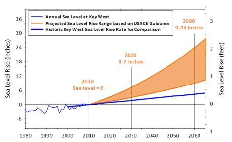
5 Unified SLR Projections: 2011 versus 2015 (using Key West gage)
 0.5 m 2.")

6 How the curves were developed Global: SLR = at + bt 2 Scenario USACE Intermediate/NOAA Intermediate Low Global Sea Level Rise by 2100 b (m/yr 2 ) 0.5 m e-05 IPCC Median 0.73 m e-05 USACE High 1.5 m e-04 NOAA High 2.0 m e-04 For computing b: a = 1.7 mm/yr (global linear rate) b = rate of acceleration and t = 0 in Year 1992 Regional: SLR = ct + bt 2 where c is a site-specific regional rate (2.2 mm/yr for Key West)
7 Why 1992? And how to translate the curve to a geodetic datum? (NGVD29 or NAVD88) Latest tidal-epoch (1992 is about the midpoint). Nodal cycle (18.6 years, so at least 19 years are needed) Need MSL with respect to a geodetic datum. Three approaches are possible: 1. When there is a tide gage nearby (Harmonic or Subordinate) use the MSL and geodetic datum relationship from tidal datum page 2. When there is a tide gage nearby and has a long term record, compute the MSL using the most recent 19-year period 3. When there is no tide gage nearby, use the VDATUM software (NOAA)


8 Example: Reference to 1992 (using epoch) Subordinate Harmonic 1/27/2016
9 Example: Computing MSL 19 years


10 Example: VDATUM (

 Inter-annual variability Seasonal Cycle Gravitational effects")
11 Other adjustments to MSL (if they are not accounted for in the regional rate) Vertical Land Movement (From tide gage analysis, GPS etc.) Ocean Dynamics Change Decline in Florida Current 15% of the projection (based on IPCC) Inter-annual variability Seasonal Cycle Gravitational effects of ice melt (Not in Compact)


12 Decline in Florida Current Transport? HYDROLOGIC & ENVIRONMENTAL SYSTEMS MODELING
 Miami Beach (2.39) Key West (2.33) Vaca Key (3.")
13 Southeast Florida (rate of rise) Lake Worth (3.36) Miami Beach (2.39) Key West (2.33) Vaca Key (3.34)

14 DoD Coastal Assessment Regional Scenario Working Group: Regionalized Scenarios for Sea-Level Change and Extreme Water Levels Worldwide DoD Coastal Assessment Regional Scenario Working Group
. Tectonic uplift (e.g.")
 Monitored through GPS (relatively short time records) or the analysis of tide-gauge data")
15 Vertical Land Movement Background and Methods Post-glacial rebound: Associated with the removal of ice sheets in the northern portion of North America & Europe. Also known as Glacial Isostatic Adjustment (GIA). Tectonic uplift (e.g., Alaska) and sedimentation Subsidence (e.g., removal of groundwater or oil, oxidation of organic matter) Monitored through GPS (relatively short time records) or the analysis of tide-gauge data (NOAA; relatively long time records in many but not all locations); data use sensitive to proximity of data measurement to site location Use coarse GIA data if have nothing else
 Dyn_slr (x,t) = global_steric_mean (t) + scale factor (x) * global_mean_air_temp (t) where t is time, x is location, e is an error term, and the scale factor denotes a normalized value to")
16 Dynamic Sea-Level Change Methods Dynamic sea level (DSL) is the collective effect of local steric effects and ocean dynamics, expressed as a global pattern scaling (Perrette et al. 2013) Dyn_slr (x,t) = global_steric_mean (t) + scale factor (x) * global_mean_air_temp (t) where t is time, x is location, e is an error term, and the scale factor denotes a normalized value to represent the pattern scaling. The quantities, global_steric_mean (t), and global_mean_air_temp (t) are the global averages of steric sea level and temperature at time t. Scale bar shows the pattern-scaling in meters per degree Centigrade 16
17 Dynamic Sea Level: Example Results Global mean temperature for each scenario and time frame was determined using a regression analysis of the data provided by Perrette et al. (2013) Pattern and magnitude scaling associated with the 1-m GMSLR scenario at Scale bar is in meters. Results for individual DoD sites for the 1-m GMSLR scenario at Scale bar is in meters. Highly non-uniform with deviations from global mean sea level that can be significant 17
18 Sea Level Fingerprints due to Rapid Melting of Ice Ice sheets exert gravitation attraction on the surrounding ocean As the ice sheet melts, gravitational force on the ocean decreases Water migrates from near field to the far fields 18
19 Sea Level Fingerprints due to Rapid Melting of Ice Methods Based on Perrette et al. (2013) and Kopp et al. (2014) Fingerprint (x) = SLR Component (x) Global Mean SLR Component (where x is the coordinates of the location and the component is either glaciers, Greenland, or Antarctica; fingerprint pattern is assumed to be independent of time and takes into account such factors as the spatial distribution of the mass loss and its effect on the geoid, earth s elastic response, shoreline change, and earth s rotation) Using Kopp s probability distribution for each component (glaciers, Greenland, Antarctica, thermal expansion, and land water storage), simulate 500,000 realizations of each for each time horizon to establish the ice melt contribution of components by scenario. Lowest GMSL scenarios (0.2, 0.5., and 1.0 m) are associated with RCP2.6, 4.5, and 8.5 scenarios. For the 1.5 and 2.0 m scenarios scaling factors were determined by sampling the high end of the distributions to derive component contributions. 19
20 Ice Melt Contributions Results (By GMSLR and Year) 5% Median 95% Comp Year GIC GrIS AIS T LW Total GIC GrIS AIS T LW Total GIC GrIS AIS T LW Total


21 Ice Melt Fingerprints Results Ice Ice melt melt adjustment adjustment for for Greenland Greenland at at for for the the 1 m 1 m GMSLR GMSLR scenario. scenario. Fingerprint scale bars are ratios of sea level contribution as a function of global mean, whereas the bottom right figure scale bar shows the deviation in meters from the global mean for ice melt from Greenland. 21

22 Sea Level Extremes Methods Hydrodynamic modeling of historic/synthetic storms Statistical modeling of sea level extremes
23 When MSL increases so does extremes

24 How high my sea wall (or roadway) should be? Three approaches (Stationary and Nonstationary) 1. Assume extremes follow MSL and add storm surge estimates to SLR 2. Conduct a non-tidal residual analysis and add the storm surge estimates to an appropriate tidal datum 3. A Nonstationary approach (directly model maximum sea level as a function of covariates ) Maximum Sea Level Mean Sea Level
25 Stationary Approach - I Year 2060 USACE Unified SLR Projection Intermediate High MSL (2005) future MSL 0.39 Ocean Dynamics 0.06 Gravitational Effects? Interannual Variability 0.05 RSLR Year Year 0.9 Future 10-yr Future-100yr /27/2016
 Credit: W. Sweet")
26 Stationary Approach - 2 SWL = Tide (astronomical + MSL seasonal cycle) + Nontidal Residual (storm surge + sea level anomaly) Credit: W. Sweet
 (Coles, 2001) 2.")
 4.")
27 Extreme Value Modeling 1. Extreme Value of Modeling of Block Maxima (BM) (Coles, 2001) 2. Extreme Value Modeling of Peaks Over Threshold (POT) (Coles 2001) 3. Mixture Distributions (MD) 4. Monte-Carlo Joint Probability Methods (Goring et al. 2011) 5. Regional Frequency Analysis (Hosking and Wallis 1997)
28 Regional Frequency Analysis (RFA) RFA is based upon a regional homogeneity assumption. Homogeneous region: group of sites whose extreme storm surge are in response to same mechanism (e.g., Nor easter impact footprint), defined by proximity, bathymetric-topographic similarities, pattern detection techniques, etc. Homogeneity is assessed with a heterogeneity measure (H): L-moments (quantifies distribution shape mean, standard deviation, skewness, kurtosis) to enable comparing the observed dispersion between sites to the expected dispersion in a homogeneous region. H<1: homogeneous; 1<H<2 possibly homogeneous; H>2: heterogeneous 28
29 Regional Frequency Analysis: Local Adjustment RFA is used to compute regional curve using annualmaximum non-tidal residual (NTR) from 3 to 5 tide gauges < 400 km away that are then fit by the family of Generalized Extreme Value (GEV) distributions Each tide gauge NTR series normalized by the average of annual maximum NTR prior to forming the regional GEV curve Local index event (i.e., mean annual maximum NTR) is used to scale the regional GEV curve Category 1 and 2: from local (< 50 km) tide gauge Category 3: average of all tide gauges Category 4: NA 29

30 Example application: C-4 basin in Miami 1/27/2016
31 Concept of Return Period and Risk: Paradigm Shift p 1 p x p t Design, z q0 μ t μ 0 p 0 < p x < p T Time Construction t 1 t Project Operation 31
32 Return Period non-stationary case (cont.) Return Period is defined as the expected time for the first exceedance (waiting time) T = E X = x=1 xf(x) = xp x Cooley (2013) provides a nice simplification: Note: Since p t is a function Z q0 (initial design or p 1 ), this can also be used to find Z q0 for a given T x=1 x 1 t=1 T = E X = 1 + (1 p t ) x=1 x t=1 (1 p t )
33 Non-stationary Concepts (Risk & Reliability) Risk n R = f(x) = p x n x 1 (1 p t ) n = 1 (1 p t ) x=1 x=1 t=1 t=1 Reliability: n R l = (1 p t ) t=1
34 Return Period & Risk Curves x T = 1 + (1 p t ) x=1 t=1 Note: 1-m scenario Stationary Non-stationary


35 "The frequency (of extreme weather situations) is way up," Andrew Cuomo, Governor of New York, 10/31/2012 1/27/


36 King Tide Flooding in South Florida Lantana Boca Delray Hollywood SFWMD-S13 Pompano Beach Big Pine Key Miami Beach Credits: Rhonda Haag, Jennifer Jurado, Natalie Schneider Key Largo

37
 Frequency of flooding increases")
 : F k = subset of k integers From")
38 Frequency of Flooding under Non- Stationarity (Starting with Nuisance Flooding ) Frequency of flooding increases with time 0 T Number of floods, N T has Poisson-Binomial distribution (Hong 2013) : F k = subset of k integers From (1,2,..T)
39 39 Frequency of Flooding: Sewell Point Non-Stationary Stationary
40 Nuisance Flooding as a design criteria


41 Further Information (paper accepted for publication in J. Hydrologic Engineering)

42 42 Questions?
Hydrologic Design under Nonstationarity
 Hydrologic Design under Nonstationarity Jayantha Obeysekera ( Obey ), SFWMD Jose D. Salas, Colorado State University Hydroclimatology & Engineering Adaptaton (HYDEA) Subcommittee Meeting May 30, 2017,
ASSESSING FUTURE EXPOSURE: GLOBAL AND REGIONAL SEA LEVEL RISE SCENARIOS FOR THE UNITED STATES
 ASSESSING FUTURE EXPOSURE: GLOBAL AND REGIONAL SEA LEVEL RISE SCENARIOS FOR THE UNITED STATES Chesapeake Bay Program Climate Resiliency Workgroup Conference Call May 15, 2017 William Sweet NOAA CO-OPS
The Science of Sea Level Rise and the Impact of the Gulf Stream
 Old Dominion University ODU Digital Commons July 29, 2016: The Latest in Sea Level Rise Science Hampton Roads Sea Level Rise/Flooding Adaptation Forum 7-29-2016 The Science of Sea Level Rise and the Impact
Sea Level Rise in Connecticut A Risk-Informed Approach
 GZA GeoEnvironmental, Inc. CAFM Conference October 25, 2017 Proactive By Design. Our Company Commitment Proactive By Design. Our Company Commitment Sea Level Rise in Connecticut A Risk-Informed Approach
HURRICANE SANDY LIMITED REEVALUATION REPORT UNION BEACH, NEW JERSEY DRAFT ENGINEERING APPENDIX SUB APPENDIX C SEA LEVEL RISE ANALYSIS
 HURRICANE SANDY LIMITED REEVALUATION REPORT UNION BEACH, NEW JERSEY DRAFT ENGINEERING APPENDIX SUB APPENDIX C SEA LEVEL RISE ANALYSIS Rev. 18 Feb 2015 1.0 Introduction 1.1 Guidance The Department of the
Sea level change around the Philippines
 Sea level Sea level around the Philippines Institute of Environmental Science for Social Change (ESSC) Conference on Internal Migration and Displacement Davao City, Philippines 20 May 2012 Regional How
A geological perspective on sea-level rise and its impacts
 A geological perspective on sea-level rise and its impacts K.G. Miller, R.E. Kopp, B.H. Horton, J.V. Browning, A.C. Kemp Front Pages November 1, 2012 kgm@rutgers.edu Ship Bottom, Long Beach Island, NJ
Sea level change recent past, present, future
 Sea level change recent past, present, future Anny Cazenave LEGOS-CNES Toulouse, France CCI_Colocation meeting, ESA/ESRIN Global mean sea level rise during the 20 th century (red : tide gauges; blue :
Sea-level change: A scientific and societal challenge for the 21 st century John Church International GNSS Service Workshop, Sydney, Feb 11, 2016
 Sea-level change: A scientific and societal challenge for the 21 st century John Church International GNSS Service Workshop, Sydney, Feb 11, 2016 OCEANS AND ATMOSPHERE NATIONAL RESEARCH FLAGSHIP Our coastal
SLR: Nuisance flooding patterns along the Coastal Bend
 SLR: Nuisance flooding patterns along the Coastal Bend Philippe Tissot Conrad Blucher Institute Resilient Texas: Planning for Sea Level Rise August 8, 2017 Hurricane Ike - 9/13/2008 Marina Photos Courtesy
Sea-Level Rise in the Humboldt Bay Region
 Sea-Level Rise in the Humboldt Bay Region Update 1: March 2018 Prepared by Jeffrey K. Anderson Northern Hydrology & Engineering P.O. Box 2515 McKinleyville, CA 95519 Preparation of this document was partially
Characterizing changes in storm surges and flood risk in the presence of sea level rise: statistical approaches and challenges
 Characterizing changes in storm surges and flood risk in the presence of sea level rise: statistical approaches and challenges Claudia Tebaldi Climate and Global Dynamics Division NCAR tebaldi@ucar.edu
Sea-Level Rise in the Humboldt Bay Region
 Local Sea-Level Rise (cm) Local Sea-Level Rise (cm) Sea-Level Rise in the Humboldt Bay Region Update 2: December 2018 350 300 250 200 150 North Spit Monthly Mean (1977-2016) RCP 8.5 RCP 2.6 Ext 2.5 RCP
Regionalizing Sea-level Rise Projections for Urban Planning
 Regionalizing Sea-level Rise Projections for Urban Planning Bob Kopp Rutgers University E-mail: robert.kopp@rutgers.edu Collaborators: Ken Miller, Ben Horton, Jim Browning, Vladimir Pavlovic (Rutgers);
Planning for Annapolis Sea Level Rise and Future Extreme Water Levels
 Planning for Annapolis Sea Level Rise and Future Extreme Water Levels U.S. Naval Academy Sea Level Rise Advisory Council 31 October 2017 CAPT Emil Petruncio, USN (Ret.), PhD Associate Professor Gina Henderson
Current Climate Science and Climate Scenarios for Florida
 Current Climate Science and Climate Scenarios for Florida Daniel Bader and Vivien Gornitz Water Utilities and Climate Change Workshop Palm Beach County Water Utilities/ Water Research Foundation June 10,
Northern European Sea Level Rise. Aslak Grinsted Centre for Ice and Climate Niels Bohr Institute University of Copenhagen
 Northern European Sea Level Rise Aslak Grinsted Centre for Ice and Climate Niels Bohr Institute University of Copenhagen Global Sea Level Rise The world is warming and this causes sea level to rise because:
Field Research Facility
 Field Research Facility Sea Level Rise Observations of Sea Level rise Forces driving change Predicting future Sea Level rise Response of land surface Storm inundation coupled with Sea Level Dr. Jesse McNinch
SEA LEVEL RISE IN THE 2017 COASTAL MASTER PLAN
 SEA LEVEL RISE IN THE 2017 COASTAL MASTER PLAN James W. Pahl, Ph.D. Coastal Resources Scientist, Senior Presentation to the Barataria-Terrebonne National Estuary Program Management Conference Meeting Nicholls
APPENDIX A: ABSOLUTE SEA LEVEL METHODS AND PROJECTION TABLES
 APPENDIX A: ABSOLUTE SEA LEVEL METHODS AND PROJECTION TABLES As described in the main body of this report, absolute sea level projections were developed using a slightly modified approach from Kopp et
Sea-Level Rise for the Coasts of California, Oregon, and Washington: Past, Present, and Future
 Sea-Level Rise for the Coasts of California, Oregon, and Washington: Past, Present, and Future Robert A. Dalrymple Committee Chair and Johns Hopkins University June 20, 2012 Global sea level is rising
Latest trends in sea level rise and storm surges in Maine Peter A. Slovinsky, Marine Geologist
 Latest trends in sea level rise and storm surges in Maine Peter A. Slovinsky, Marine Geologist Image from Chebeague.org Maine s glacial geology and historic sea level rise trends Current sea level trends
Oceans and Climate. Caroline Katsman. KNMI Global Climate Division
 Oceans and Climate Caroline Katsman KNMI Global Climate Division Aimée Slangen, Roderik van de Wal (IMAU, Utrecht University) Sybren Drijfhout, Wilco Hazeleger (KNMI, Global Climate) Bert Vermeersen (NIOZ/Delft
What we know about regional sea level rise and how we are affected by variations from the global mean
 regional sea level rise and variations from the global Magnus Hieronymus 2018 Regional and Global Sea level Global Density change: thermosteric Regional Density change: thermosteric+ halosteric Land Ice
Tony Pratt, DNREC to The Center for the Inland Bays Scientific and Technical Advisory Committee. August 21, 2009
 Sea Level Rise in Delaware Presented by Tony Pratt, DNREC to The Center for the Inland Bays Scientific and Technical Advisory Committee August 21, 2009 Sea level has been fluctuating ever since there have
Future Sea Level Rise and its Implications for SIDS and LDCs
 Future Sea Level Rise and its Implications for SIDS and LDCs Bill Hare, Michiel Schaeffer, Mahé Perrette, Matthias Mengel COP17, Durban, 2 nd December Overview Part 1: Global sea level: past and future
Assessing the local impacts of sea level rise
 Assessing the local impacts of sea level rise Ian Miller, Coastal Hazards Specialist Washington Sea Grant MRC Conference Port Townsend, WA 5 December 2014 With contributions from: Eric Grossman, USGS;
Towards an integrated assessment of coastal flood risk in southern China.
 Towards an integrated assessment of coastal flood risk in southern China. ADAM D. SWITZER EARTH OBSERVATORY OF SINGAPORE ASIAN SCHOOL OF THE ENVIRONMENT NANYANG TECHNOLOGICAL UNIVERSITY http://timeout
Regional and global trends
 SEA LEVEL RISE Regional and global trends OCEANOBS 2009 Plenary Paper A.Cazenave D. Chambers, P. Cipollini, J. Hurell, S. Nerem, L.L. Fu, H.P. Plag, C.K. Shum, J. Willis Venice, September 2009 Global mean
Section 145 Climate Change and Sea Level Rise
 Section 145 Climate Change and Sea Level Rise A. Definitions Rhode Island Coastal Resources Management Program 1. Climate is the long-term weather average observed within a geographic region, and climate
Sea-level Rise on Cape Cod: How Vulnerable Are We? Rob Thieler U.S. Geological Survey Woods Hole, MA
 Sea-level Rise on Cape Cod: How Vulnerable Are We? Rob Thieler U.S. Geological Survey Woods Hole, MA Outline Sea-level and coastal processes Past sea-level change Predictions for the future Coastal responses
The oceans: Sea level rise & gulf stream
 Lecture Climate Change Lesson 10 The oceans: Sea level rise & gulf stream Rene Orth rene.orth@bgc-jena.mpg.de 1 Course webpage https://www.bgc-jena.mpg.de/bgi/index.php/lectures/hydrobioclimclimatechange
GNSS Observations & Sea Level
 with contributions from: - Marta Marcos - Alvaro Santamaria - GNSS Observations & Sea Level Guy Wöppelmann gwoppelm@univ-lr.fr Outline: 1. Introduction 2. The importance of Vertical Land Motions 3. The
Geodetic Observing Systems: tools in observing the Glacial Isostatic Adjustment. Markku Poutanen Finnish Geodetic Institute
 Geodetic Observing Systems: tools in observing the Glacial Isostatic Adjustment Markku Poutanen Finnish Geodetic Institute Glacial Isostatic Adjustment Land uplift is just one consequence of the physical
Town of Old Orchard Beach: A summary of sea level rise science, storm surge, and some highlighted results from SLAWG work efforts
 Town of Old Orchard Beach: A summary of sea level rise science, storm surge, and some highlighted results from SLAWG work efforts October 15, 2013 Peter A. Slovinsky, Marine Geologist Maine Geological
Hurricanes, Sea Level Rise, and South Florida s Challenging Future
 Hurricanes, Sea Level Rise, and South Florida s Challenging Future Brian McNoldy Senior Research Associate University of Miami Tropical Weather Expert Washington Post Scientific Advisor Coastal Risk Consulting
Sea Level Rise Study Summary Town of South Bethany
 Sea Level Rise Study Summary Town of South Bethany This presentation was prepared by Anchor QEA for the Town of South Bethany using Federal Funds under award NA14 NOS 419 0123 from the Delaware Coastal
Sea level change. Eustatic sea level change. Tectono-eustasy. Tectonic control of global sea level. Global signal of sea level change Causes:
 Sea level change Important processes Global vs. local Geologic Modern Current rates of rise Observations, calculations, and models Lessons from the past Projected future changes Eustatic sea level change
Harnessing the Power of Earth System Science for Developing Science Practices and Crosscutting Concepts
 Harnessing the Power of Earth System Science for Developing Science Practices and Crosscutting Concepts Roberta Johnson, Richard Jones, Joe Monaco, Wendy Van Norden, Michael Passow, National Earth Science
GSC 107 Lab # 3 Calculating sea level changes
 GSC 107 Lab # 3 Calculating sea level changes Student name Student ID Background Glacial-Interglacial Cycles Climate-related sea-level changes of the last century are very minor compared with the large
Belfast Sea Level Rise A Briefing for Policy Makers
 Belfast Sea Level Rise A Briefing for Policy Makers Version 3, issued 16/02/17 This paper briefly sets out the relative current rate of sea level rise in Belfast, and how this increases the risk of coastal
NOAA s National Ocean Service. Center for Operational Oceanographic Products and Services
 NOAA s National Ocean Service Center for Operational Oceanographic Products and Services Richard Edwing, CO-OPS Acting Director January 27, 2010 Outline CO-OPS Overview Programs Observing Systems PORTS
Physical Dynamics of the Coastal Zone in the Mediterranean on Annual to Decadal Scales
 Physical Dynamics of the Coastal Zone in the Mediterranean on Annual to Decadal Scales Hans-Peter Plag Nevada Bureau of Mines and Geology and Seismological Laboratory University of Nevada, Reno, Nevada,
Model projections of Centuryscale change in Extreme Sea- Level for UKCP09 and UKCP18
 Model projections of Centuryscale change in Extreme Sea- Level for UKCP09 and UKCP18 SL SpaceWatch workshop 2016 03 22 Tom Howard, Matt Palmer, Jon Tinker, Jason Lowe,. Contents Overview of UKCP18 Marine
Sea level over glacial cycles.
 Sea level over glacial cycles. T1: 1 m/century With short periods of with rates up to 4m/century LIG Sea level higher than today (+9m) Siddall et al. 2003 Very stable sea level in human history. Image
Preliminary Data Release for the Humboldt Bay Sea Level Rise Vulnerability Assessment: Humboldt Bay Sea Level Rise Inundation Mapping
 Preliminary Data Release for the Humboldt Bay Sea Level Rise Vulnerability Assessment: Humboldt Bay Sea Level Rise Inundation Mapping Prepared by: Jeff Anderson, Northern Hydrology & Engineering (jeff@northernhydrology.com)
Florida Flood Risks. Heavy Rainfall. Groundwater. Tidal Flooding. Storm Surge. King Tides. Runoff/Riverine
 Florida Flood Risks Heavy Rainfall Storm Surge Groundwater Tidal Flooding Runoff/Riverine King Tides Sawgrass Mills Mall Sunrise, Florida 15 of rain in 3 days, with most in 24 hours. Mall closed for 3
Projecting regional sea-level changes for the 21 st century
 Projecting regional sea-level changes for the 21 st century Aimée Slangen In collaboration with Mark Carson (CEN Hamburg), Caroline Katsman (KNMI), Roderik van de Wal (IMAU), Armin Köhl (CEN Hamburg),
POLAR EXPLORER EXPLORING SEA LEVEL RISE
 POLAR EXPLORER EXPLORING SEA i LEVEL RISE Developed by: Margie Turrin, mkt@ldeo.columbia.edu As a polar explorer you and your team will be collec@ng evidence of changes occurring throughout the world that
COASTAL DATA APPLICATION
 2015 Coastal GeoTools Proactive By Design. Our Company Commitment COASTAL DATA APPLICATION Projecting Future Coastal Flood Risk for Massachusetts Bay Bin Wang, Tianyi Liu, Daniel Stapleton & Michael Mobile
CLIMATE READY BOSTON. Climate Projections Consensus ADAPTED FROM THE BOSTON RESEARCH ADVISORY GROUP REPORT MAY 2016
 CLIMATE READY BOSTON Sasaki Steering Committee Meeting, March 28 nd, 2016 Climate Projections Consensus ADAPTED FROM THE BOSTON RESEARCH ADVISORY GROUP REPORT MAY 2016 WHAT S IN STORE FOR BOSTON S CLIMATE?
A Tutorial on Climate Change Science: The. 4 th National Climate Assessment CLIMATE SCIENCE. Don Wuebbles
 CLIMATE SCIENCE S P E C I A L R E P O R T A Tutorial on Climate Change Science: The Fourth National Climate Assessment Volume I 4 th National Climate Assessment Don Wuebbles Department of Atmospheric Sciences
Projecting the uncertainty of sea level rise using climate models and statistical downscaling!
 Projecting the uncertainty of sea level rise using climate models and statistical downscaling! Peter Guttorp! Norsk Regnesentral! University of Washington! Outline! The importance of sea level rise! Measuring
Developing Long-Term Coastal Erosion Hazard Maps ASFPM Conference Seattle, WA
 ASFPM 2014 Annual Conference Developing Long-Term Coastal Erosion Hazard Maps ASFPM Conference Seattle, WA Jeremy Mull, P.E. Elena Drei-Horgan, Ph.D. June 5 th, 2014 Presentation Outline Overview of Great
Turn and Face the Strange: Economic Impacts of Climate Change Sea Level Rise and Coastal Flooding E2Tech Forum June 21, 2018
 Turn and Face the Strange: Economic Impacts of Climate Change Sea Level Rise and Coastal Flooding E2Tech Forum June 21, 2018 Peter A. Slovinsky, Marine Geologist Maine Geological Survey Image from Chebeague.org
Coastal and Marine Projections for the Natural Resource Management Regions of Australia
 Coastal and Marine Projections for the Natural Resource Management Regions of Australia The Australian Coastal Councils Association Conference, May 4, 2016, Rockingham, WA Kathleen McInnes John Church,
Beyond 2100: Committed Sea Level Rise in South Florida Produced by 21st Century Global Temperature Rise
 Beyond 2100: Committed Sea in South Florida Produced by 21st Century Global Temperature Rise Presented by: Pete Harlem Presented at GIS Day November 6, Pete Harlem, Jack Meeder and Randy Parkinson It s
Exploring The Polar Connection to Sea Level Rise NGSS Disciplinary Core Ideas Science & Engineering Crosscutting Concepts
 Exploring The Polar Connection to Sea Level Rise NGSS Disciplinary Core Ideas Science & Engineering Crosscutting Concepts Practices MS - ESS: Earth & Space Science 1. Ask questions 2. Developing and using
Future sea level rise through 2100 and beyond
 Future sea level rise through 2100 and beyond Emma Stone Uncertain World Summit (Tuesday 20 October 2015) 1 Why are we interested in future sea level rise? How certain are we about the worst case scenario
A process-based approach toward assessing the coastal impact of projected sea level rise and severe storms
 A process-based approach toward assessing the coastal impact of projected sea level rise and severe storms Patrick Barnard 1, Cheryl Hapke 2, Li Erikson 1, Amy Foxgrover 1, and Maarten van Ormondt 3 1
Town of Cape Elizabeth: A summary of some of the latest sea level rise science and storm surge data to help guide municipal ordinance changes
 Town of Cape Elizabeth: A summary of some of the latest sea level rise science and storm surge data to help guide municipal ordinance changes May 29, 2014 Peter A. Slovinsky, Marine Geologist Maine Geological
Draft for Discussion 11/11/2016
 Coastal Risk Consulting (CRC) Climate Vulnerability Assessment for Village of Key Biscayne Deliverable 1.1 in Statement of Work. Preliminary Vulnerability Assessment Identifying Flood Hotspots Introduction...
Sea Level Rise and Coastal Inundation Thursday 11 th October, 2012, 1.00pm, With lunch in the Legislative Council Committee Room
 The Presiding Officers invite Parliamentarians and Staff to a Science Briefing on Sea Level Rise and Coastal Inundation Thursday 11 th October, 2012, 1.00pm, With lunch in the Legislative Council Committee
GRACE Measurement of Total Water Storage Variations Over Texas
 GRACE Measurement of Total Water Storage Variations Over Texas Byron Tapley, Srinivas Bettadpur Himanshu Save, Tatyana Pekker University of Texas Center for Space Research First Texas Water Forum - Drought
PROJECTIONS OF RELATIVE SEA-LEVEL RISE OVER THE NEXT CENTURY Luca Parlagreco and Sergio Silenzi
 LIFE08 ENV/IT/436 PROJECTIONS OF RELATIVE SEA-LEVEL RISE OVER THE NEXT CENTURY Luca Parlagreco and Sergio Silenzi Rome July 2010 ISPRA Institute for Environmental Protection and Research Climate change
Rising Sea Levels: Time for Proactive Action in Florida and the Caribbean?
 Rising Sea Levels: Time for Proactive Action in Florida and the Caribbean? Dr. Alan Fyall and Dr. Thomas Wahl National Center for Integrated Coastal Research, University of Central Florida Dr. Roberta
Crystal Goodison & Alexis Thomas University of Florida GeoPlan Center
 Crystal Goodison & Alexis Thomas University of Florida GeoPlan Center A1A Fort Lauderdale, Hurricane Sandy, October 2012 Photo Credits: Susan Stocker, Sun Sentinel FAU s Research Report (completed Jan
Sea Level Rise in Miami-Dade County Florida Implications for Management of Coastal Wetlands and the Everglades
 Sea Level Rise in Miami-Dade County Florida Implications for Management of Coastal Wetlands and the Everglades Peter W. Harlem Dr. John F. Meeder Florida International University Southeast Environmental
NRC Workshop - Probabilistic Flood Hazard Assessment Jan 2013
 Regional Precipitation-Frequency Analysis And Extreme Storms Including PMP Current State of Understanding/Practice Mel Schaefer Ph.D. P.E. MGS Engineering Consultants, Inc. Olympia, WA NRC Workshop - Probabilistic
South San Francisco Bay Shoreline Studies for EIA 11 with Project Conditions
 South San Francisco Bay Shoreline Studies for EIA 11 with Project Conditions U.S. Army Corps of Engineers San Francisco District Ms. Lisa Andes Mr. Craig Conner Dr. Frank Wu Dr. Jen-Men Lo Dr. Michael
Global sea level projections by Svetlana Jevrejeva National Oceanography Centre, Liverpool, UK
 Global sea level projections by 2100 Svetlana Jevrejeva National Oceanography Centre, Liverpool, UK sveta@noc.ac.uk Outline Cause of sea level rise/sea level budget Global sea level projections by 2100:
Analysis of Tides and Storm Surge from Observational Records in the Delaware Inland Bays
 Analysis of Tides and Storm Surge from Observational Records in the Delaware Inland Bays John Callahan Delaware Geological Survey Coastal GeoTools Conference March 30 April 2, 2015 Charleston, SC Outline
Sea-level Rise Projections
 Updating Maryland s Sea-level Rise Projections Scientific and Technical Working Group Maryland Climate Change Commission June 26, 2013 1 5 8 16 18 Table of contents Introduction 1 Sea-level Rise and the
Projecting regional sea-level changes for the 21 st century
 Projecting regional sea-level changes for the 21 st century Aimée Slangen Postdoctoral research fellow In collaboration with: Mark Carson (CEN Hamburg), Caroline Katsman (KNMI), Roderik van de Wal (IMAU),
PROCESSES CONTRIBUTING TO THE GLOBAL SEA LEVEL CHANGE
 Second Split Workshop in Atmospheric Physics and Oceanography PROCESSES CONTRIBUTING TO THE GLOBAL SEA LEVEL CHANGE Student: Maristella Berta Mentor: Prof. Stjepan Marcelja Split, 24 May 2010 INTRODUCTION
Modeling Sea Level Rise in Caribbean SIDS: The Need for Tide Gauge Data
 Modeling Sea Level Rise in Caribbean SIDS: The Need for Tide Gauge Data Michael Sutherland and Demi Singh Department of Geomatics Engineering and Land Management Faculty of Engineering University of the
Sea Level. John Church WCRP Antarctic Climate and Ecosystems CRC Centre for Australian Weather and Climate Research
 Sea Level John Church WCRP Antarctic Climate and Ecosystems CRC Centre for Australian Weather and Climate Research Sea level rose by more than 120 m since the last glacial maximum 2 Church et al., 2008
Appendix A STORM SURGE AND WAVE HEIGHT ANALYSIS
 Appendix A STORM SURGE AND WAVE HEIGHT ANALYSIS Memo To: Jeff Robinson, P.E., GEC, Inc. From: Silong Lu, Ph.D., P.E., D.WRE, Dynamic Solutions, LLC. Date: 1/9/2014 CC: Re: Chris Wallen, Vice President,
Ecole d Eté Altimétrie spatiale. Sea level variations at climatic time scales: observations & causes. Benoit Meyssignac
 Ecole d Eté 2014 Altimétrie spatiale Sea level variations at climatic time scales: observations & causes Benoit Meyssignac 1 Ecole d Eté 2014, Saint-Pierre d Oléron, 1-5 septembre 2014 Echelles climatiques
Climate Change: Understanding Recent Changes in Sea Level and the Ocean. Sea Level Rise
 Climate Change: Understanding Recent Changes in Sea Level and the Ocean Sea Level Rise Philip L. Woodworth Proudman Oceanographic Laboratory, Liverpool ASE/BA/City of Culture Evening 18 October 2007 Long
Exploring extreme sea level events
 PSMSL 80 th Anniversary Workshop on Sea Level Science Exploring extreme sea level events Melisa Menéndez Environmental Hydraulics Institute (IH-Cantabria), Universidad de Cantabria, Spain menendezm@unican.es
Guidance for Sea Level in 2100
 Guidance for Sea Level in 2100 Focus on Ice Melt - The Big Unknown Jim Houston 1 and Bob Dean 2 ¹ Director Emeritus, Army Engineer Research and Development Center, Corps of Engineers 2 Professor Emeritus,
Should I Sell My Shore House? NJ As a Natural Laboratory for Sea-level Change Ken Miller, Chair of Geological Sciences (FAS)
") Should I Sell My Shore House? NJ As a Natural Laboratory for Sea-level Change Ken Miller, Chair of Geological Sciences (FAS) Hurricane Isabelle, Avalon, NJ 9/18/2003 December Nor easter, LBI, 12/1993 Ash
Should I Sell My Shore House? NJ As a Natural Laboratory for Sea-level Change Ken Miller, Chair of Geological Sciences (FAS) Hurricane Isabelle, Avalon, NJ 9/18/2003 December Nor easter, LBI, 12/1993 Ash
North Atlantic Coast Comprehensive Study (NACCS) APPENDIX A: ENGINEERING
 APPENDIX A: ENGINEERING") North Atlantic Coast Comprehensive Study (NACCS) APPENDIX A: ENGINEERING NORTH ATLANTIC COAST COMPREHENSIVE STUDY: RESILIENT ADAPTATION TO INCREASING RISK Appendix A - Engineering Table of Contents North
North Atlantic Coast Comprehensive Study (NACCS) APPENDIX A: ENGINEERING NORTH ATLANTIC COAST COMPREHENSIVE STUDY: RESILIENT ADAPTATION TO INCREASING RISK Appendix A - Engineering Table of Contents North
Mapping of Future Coastal Hazards. for Southern California. January 7th, David Revell, Ph.D. E.
 Mapping of Future Coastal Hazards for Southern California January 7th, 2014 David Revell, Ph.D. drevell@esassoc.com E. Vandebroek, 2012 Outline Coastal erosion hazard zones Flood hazard zones: Coastal
New satellite mission for improving the Terrestrial Reference Frame: means and impacts
 Fourth Swarm science meeting and geodetic missions workshop ESA, 20-24 March 2017, Banff, Alberta, Canada New satellite mission for improving the Terrestrial Reference Frame: means and impacts Richard
Sea-Level Rise Impacts on South Florida
 Sea-Level Rise Impacts on South Florida Keren Prize Bolter, PhD Science Director, Coastal Risk Consulting. LLC 5/3/16 FAQ list What is happening? What impacts are we already seeing? Just how vulnerable
New perspectives on old data: What the earth s past tells us about future sea level rise
 New perspectives on old data: What the earth s past tells us about future sea level rise Bindschadler, Science, 1998 Andrea Dutton Department of Geological Sciences University of Florida Historical record
Past, present and future
 Southern New Jersey and Delaware sea levels: Past, present and future Benjamin P. Horton Sea Level Research Department of Marine and Coastal Science Rutgers University bphorton@marine.rutgers.edu DRIVERS
How significant is the dynamic component of the North American vertical datum?
 CGU Annual Scientific Meeting -8 June 212, Banff, Canada How significant is the dynamic component of the North American vertical datum? E. Rangelova, M.G. Sideris (University of Calgary) W. van der Wal
B. The Observed Changes in the Climate System
 gases (decades to centuries), and, as a result, their concentrations respond much more quickly to changes in emissions. Volcanic activity can inject large amounts of sulphur-containing gases (primarily
Sea level changes around Thailand
 Final symposium 27 May Bangkok, Thailand Sea level changes around Thailand Marc Naeije Contents GEO2TECDI- SONG: measuring sea level around Thailand Concept of satellite altimetry Concept of tide gauges
Regional Frequency Analysis of Extreme Climate Events. Theoretical part of REFRAN-CV
 Regional Frequency Analysis of Extreme Climate Events. Theoretical part of REFRAN-CV Course outline Introduction L-moment statistics Identification of Homogeneous Regions L-moment ratio diagrams Example
Modelling Sea-Level Rise in the Lisbon city coastal area, using Free and Open Source Technologies
 Modelling Sea-Level Rise in the Lisbon city coastal area, using Free and Open Source Technologies B. Neves(1), C. Rebelo(1) and A.M. Rodrigues(1) (1) e-geo Research Centre for Geography and Regional Planning,
Preliminary Vulnerability Assessment of Coastal Flooding Threats - Taylor County, Florida
 Preliminary Vulnerability Assessment of Coastal Flooding Threats - Taylor County, Florida North Central Florida Regional Planning Council Northeast Florida Regional Council April 28, 2016 BACKGROUND This
Global Warming and Changing Sea Level. Name: Part 1: Am I part of the problem?!
 Part 1: Am I part of the problem?! Name: The consumption of energy in the form of fossil fuel combustion is the largest single contributor to anthropogenic greenhouse gas emissions in the U.S. and the
Changes in Marine Extremes. Professor Mikis Tsimplis. The LRET Research Collegium Southampton, 11 July 2 September 2011
 Changes in Marine Extremes by Professor Mikis Tsimplis The LRET Research Collegium Southampton, 11 July 2 September 2011 1 Changes in marine extremes Mikis Tsimplis, School of Law and National Oceanography
Sea Level Rise and the Scarborough Marsh Scarborough Land Trust Annual Meeting April 24, 2018
 Sea Level Rise and the Scarborough Marsh Scarborough Land Trust Annual Meeting April 24, 2018 Peter A. Slovinsky, Marine Geologist Maine Geological Survey Funded by: 50% 40% Figure modified from Griggs,
Claim: Global warming is resulting in rising sea levels as seen in both tide gauge and satellite technology
 Claim: Global warming is resulting in rising sea levels as seen in both tide gauge and satellite technology REBUTTAL This claim is demonstrably false. It really hinges on this statement -- Tide gauges
Sea Level Variability in the East Coast of Male, Maldives
 Sea Level Variability in the East Coast of Male, Maldives K.W. Indika 1 *, E.M.S. Wijerathne 2, G. W. A. R. Fernando 3, S.S.L.Hettiarachchi 4 1 National Aquatics Resources Research and Development Agency,