Using Sea-level Pressure to Improve Surface Wind Retrievals Derived From Satellite Synthetic Aperture Radar Images of Tropical Cyclones
|
|
|
- Scot White
- 6 years ago
- Views:
Transcription
; Jochen Horstmann (NURC); Silvia Falchetti (NURC); Roland Romeiser (RSMAS/UM), Mike Caruso & Hans Graber (CSTARS))")
1 Using Sea-level Pressure to Improve Surface Wind Retrievals Derived From Satellite Synthetic Aperture Radar Images of Tropical Cyclones Ralph Foster, APL, University of WA Jerome Patoux, Atmospheric Sciences, University of WA (with significant input from Chris Wackerman (GD); Jochen Horstmann (NURC); Silvia Falchetti (NURC); Roland Romeiser (RSMAS/UM), Mike Caruso & Hans Graber (CSTARS)) Super-Typhoon Megi, 17-Oct-2010
2 Science Question How can we best use surface pressure data to improve SAR winds in TC conditions? Pressure data usually reliable even in severe storms Bulk pressure gradients dynamically relevant Pixel-by-pixel wind retrieval may not always be possible in high winds Cross-beam & Up-beam in high wind conditions? Wind direction uncertainty OLE direction Vs. Wind direction Choice of OLE spatial scale High sensitivity at low incidence angles Sigma0 uncertainty (especially low incidence angle) SLP allows scene-wide wind retrievals Use Pixel-by-pixel as initial guess Integrating/smoothing operation Fill small to moderate sized gaps Dynamic constraint on wind directions Tends to increase inner core inflow SLP is a useful measure of storm intensity Pressure-Wind relationships
")
 = 0 swath of P Fit a")
3 U10 GMF Estimate direction OLE, streaks, etc. interpolate Uinterior TCBL model (Foster, 2005, 2009) (Spurious & missing Vectors tolerated) Derive new surface wind field σ0 div(ugeo) = 0 swath of P Fit a surface pressure field
4 CMOD5 Geophysical Model Function (GMF) Ambiguity Problem in High Winds, Low Incidence Angles (θ) Slice through CMOD5 for particular viewing geometry Note sensitivity to small direction (ψ) changes
5 Storm Fanapi Fanapi Fanapi Malakas Malakas Malakas Megi Megi Megi Megi Megi Megi Megi Megi Megi Megi Megi Megi ITOP 2010SAR Eye Hits and Near Misses Date (UTC) Time (UTC) Satellite Band Polarization :23 RSAT-2 C :08 RSAT-2 C HH/HV :14 RSAT-2 C HH/HV :03 RSAT-2 C HH/HV :49 RSAT-2 C HH/HV :27 Cosmo-SkyMed-3 X :02 RSAT-2 C HH/HV :58 Cosmo-SkyMed-3 X :17 Cosmo-SkyMed-2 X :00 RSAT-2 C :17 Cosmo-SkyMed-3 X :27 EnviSAT C :35 Cosmo-SkyMed-3 X :41 RSAT-2 C :53 Cosmo-SkyMed-3 X :12 Cosmo-SkyMed-3 X :41 Cosmo-SkyMed-1 X :30 Cosmo-SkyMed-3 X Estimated Eyes Near Miss Near Miss Near Miss 19.70, Near Miss Cold Wake need to order Miss Miss 16.97, , , , , , , , , C130flight (+9hrs) (+6hrs) (+5hrs) (-5hrs) (-5hrs) (in route) (-6hrs); (+7 hrs) (-6hrs); (+7 hrs) no flights available no flights available no flights available Green =C130in stormmatches Yellow =C130 not in stormbut in route Red =C130time in stormdoes not match
6 ITOP: Typhoon (Cat 1) Malakas Malakas 22 Sep, 2010 (Great test case) C130 arrived on scene within 15 minutes of SAR overpass (15 min to 8 hour time difference overall) 28 Drop Sondes; corrected for storm translation SFMR/Flight level data analysis in progress Malakas 24 Sep, 2010 C130 Bracketed SAR overpass (8 hours before or 8 hours after) SAR near-miss on eye

7 XOVM-lite? ASCAT RSAT-2 ASCAT


8 RSAT-2 (HH) Malakas :30 Note: SLP-refinement of wind directions reduces extent of no-solution at low incidence angles


9 Surface Wind Divergence MODIS + 8 hr 10-3 s-1

10 Adjusted 22 Sep 2010 C-130 flight to SAR Overpass C130: 14:42 to 02:34 SAR: 20:30 (to Guam)


11 Malakas 22Sep :30 One Iteration Comparison with Drop Sondes (CMOD5 with SLP-Azimuths gap-fill with SLP-winds)
12 Malakas 22 Sep :03 UTC N(N-1)/2 Pairs of sondes N = 28 N(N-1)/2 = 378

13 Malakas 24 Sep, :47 UTC Larger adjustment of C-130: 13:29 to 22:02
14 Super-Typhoon Megi 17 Oct, 2010 Reached Cat-5 MSLP = 885 mb (JMA) Devastating landfall on Luzon 19 killed 200,000 homeless
15
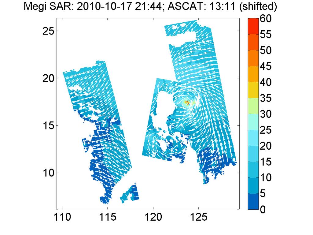
16 Major Challenge RSAT-2 21:41 Near Cat 5 Strength ~weakening phase Eye in low incidence angles Extreme conditions for GMF C :50 to 18:44 ~6 hour shift to SAR Deepening Phase
 Input")
17 Lower Ambiguity Higher Ambiguity inner core only: R < 35 km (<200 pix) Input winds
18


19 Megi 17-Oct :43 Surface wind divergence 21:43
20 Megi 17-October :43 C-130 shift error? No more than half of error due to Time difference
21 Drop Sonde SLP Summary ATL (Blue): Katrina Ike Helene Lili WPAC (Green): Malakas Malakas Megi
22 ITOP-only Drop Sonde 10m Wind Vector Summary
23 Progress so far Successfully adapted Sea-Level Pressure retrievals to 1-km-scale SAR winds in Tropical Cyclones Major improvements to Tropical Cyclone Boundary Layer (TCBL) model Available SAR-derived sea-level pressure patterns agree well with near-in-time drop sondes (4 ATL cases plus 2 of the ITOP scenes) ~1 mb RMS between SAR and drop Sondes ~3 mb RMS storm by storm (fairest score) Including extreme case (Megi17) significantly degrades this score SLP-derived surface wind patterns remove much of the most egregious GMF-induced and/or direction error induced surface wind artifacts Iterating directions with TCBL model seems to improve wind retrievals SLP errors scale with wind speed errors (clearly seen in Megi17)
24 Near-Future SFMR wind comparisons CMOD5N & IWRAP GMFs Implement optimization scheme to produce optimal surface wind field consistent with SAR, drop sondes, SFMR and in situ data from ITOP Examine all remaining ITOP imagery (C-band and X-band) Use these data to evaluate GMFs (X-band, C-band)
25 SLP speed has generally: less scatter than CMOD5 (filtering effect) better agreement at high winds due to reduced hourglassing Katrina27
Retrieving Surface Wind Directions from Neural-Net Wind Speed Retrievals in Tropical Cyclones
 Retrieving Surface Wind Directions from Neural-Net Wind Speed Retrievals in Tropical Cyclones Ralph Foster, Applied Physics Laboratory, University of WA Jerome Patoux, Atmospheric Sciences, University
Cyclones. J. Horstmann, S. Falchetti, S. Maresca. NATO Undersea Research Center, Italy UNCLASSIFIED
 SAR Wind Field Retrieval with SAR Wind Field Retrieval Respect to Tropical Cyclones with Respect to Tropical Cyclones funded by ONR Code 32 J. Horstmann, S. Falchetti, S. Maresca NATO Undersea Research
Using Surface Pressure to Improve Tropical Cyclone / Surface Wind Retrievals From SAR
 DISTRIBUTION STATEMENT A. Approved for public release; distribution is unlimited. Final Report: Using Surface Pressure to Improve Tropical Cyclone / Surface Wind Retrievals From SAR PI Ralph Foster Applied
Progress in Calculating Tropical Cyclone Surface Wind Inflow from OVW Observations
 Progress in Calculating Tropical Cyclone Surface Wind Inflow from OVW Observations Ralph Foster, APL, University of Washington, Seattle, WA Jun Zhang, HRD, NOAA, Miami, FL Peter Black, Salinas, CA IOVWST
Using Surface Pressure to Improve Tropical Cyclone Surface Wind Retrievals form Synthetic Aperture Radar Imagery
 DISTRIBUTION STATEMENT A. Approved for public release; distribution is unlimited. Using Surface Pressure to Improve Tropical Cyclone Surface Wind Retrievals form Synthetic Aperture Radar Imagery PI Ralph
Estimation of Temporally Evolving Typhoon Winds and Waves from Synthetic Aperture Radar
 DISTRIBUTION STATEMENT A. Approved for public release; distribution is unlimited. Estimation of Temporally Evolving Typhoon Winds and Waves from Synthetic Aperture Radar David Walker SRI International
Ocean Surface Wind Speed of Hurricane Helene Observed by SAR
 Available online at www.sciencedirect.com Procedia Environmental Sciences 10 (2011 ) 2097 2101 2011 3rd International Conference on Environmental Science and Information Conference Application Title Technology
Ocean Vector Winds in Storms from the SMAP L-Band Radiometer
 International Workshop on Measuring High Wind Speeds over the Ocean 15 17 November 2016 UK Met Office, Exeter Ocean Vector Winds in Storms from the SMAP L-Band Radiometer Thomas Meissner, Lucrezia Ricciardulli,
Hurricane Structure: Theory and Diagnosis
 Hurricane Structure: Theory and Diagnosis 7 March, 2016 World Meteorological Organization Workshop Chris Landsea Chris.Landsea@noaa.gov National Hurricane Center, Miami Outline Structure of Hurricanes
Zorana Jelenak Paul S. Chang Khalil Ahmed (OPC) Seubson Soisuvarn Qi Zhu NOAA/NESDIS/STAR-UCAR
 Seubson Soisuvarn Qi Zhu NOAA/NESDIS/STAR-UCAR") Near Real Time ASCAT Wind Vectors at NOAA and High Wind Issue Zorana Jelenak Paul S. Chang Khalil Ahmed (OPC) Seubson Soisuvarn Qi Zhu NOAA/NESDIS/STAR-UCAR ASCAT Wind Processing Implemented at NOAA Feb
Near Real Time ASCAT Wind Vectors at NOAA and High Wind Issue Zorana Jelenak Paul S. Chang Khalil Ahmed (OPC) Seubson Soisuvarn Qi Zhu NOAA/NESDIS/STAR-UCAR ASCAT Wind Processing Implemented at NOAA Feb
Specification of Tropical Cyclone Parameters From Aircraft Reconnaissance. Andrew Cox and Vincent Cardone Oceanweather Inc.
 Specification of Tropical Cyclone Parameters From Aircraft Reconnaissance Andrew Cox and Vincent Cardone Oceanweather Inc. Cos Cob, CT, USA Motivation This paper is part of on-going work to improve the
TC Ocean Field Experiments and New Research Findings: Examples from CBLAST, TPARC/ TCS 08, ITOP
 Topic 1 1 TC Structure and Intensity Change Special Focus Topic 1b: Ocean Field Experiments and New Research Findings TC Ocean Field Experiments and New Research Findings: Examples from CBLAST, TPARC/
WIND FIELDS RETRIEVED FROM SAR IN COMPARISON TO NUMERICAL MODELS
 WIND FIELDS RETRIEVED FROM SAR IN COMPARISON TO NUMERICAL MODELS Jochen Horstmann, Wolfgang Koch, and Susanne Lehner 2 GKSS Research Center, Max-Planck-Str., D-2 Geesthacht, Tel. +4 42 87 67, Fax: +4 42
Incorporation of New Nonlinear Similarity PBL Model in Ocean Vector Wind Surface Pressure
 Incorporation of ew onlinear Similarity PBL Model in Ocean Vector Wind Surface Pressure Retrievals Ralph Foster, APL, University of Washington Jerome Patoux, R.A. Brown, Atmospheric Sciences, University
Improved Tropical Cyclone Boundary Layer Wind Retrievals. From Airborne Doppler Radar
 Improved Tropical Cyclone Boundary Layer Wind Retrievals From Airborne Doppler Radar Shannon L. McElhinney and Michael M. Bell University of Hawaii at Manoa Recent studies have highlighted the importance
STATUS ON THE USE OF SCATTEROMETER DATA AT METEO FRANCE
 STATUS ON THE USE OF SCATTEROMETER DATA AT METEO FRANCE Christophe Payan Centre National de Recherches Météorologiques, M CNRS-GAME CNRS and Météo-France Toulouse, France 9th International Winds Workshop,
RADARSAT-1 Hurricane Watch program contribution to wind field model development
 RADARSAT-1 Hurricane Watch program contribution to wind field model development Steve Iris 1, Hans C. Graber 2 1 Canadian Space Agency, St-Hubert, Quebec, J3Y 8Y9, Canada - steve.iris@space.gc.ca 2 CSTARS
Derrick Herndon and Chris Velden University of Wisconsin - Madison Cooperative Institute for Meteorological Satellite Studies
 Derrick Herndon and Chris Velden University of Wisconsin - Madison Cooperative Institute for Meteorological Satellite Studies Presented at International Workshop on Satellite Analysis of Tropical Cyclones
P1.6 Simulation of the impact of new aircraft and satellite-based ocean surface wind measurements on H*Wind analyses
 P1.6 Simulation of the impact of new aircraft and satellite-based ocean surface wind measurements on H*Wind analyses Timothy L. Miller 1, R. Atlas 2, P. G. Black 3, J. L. Case 4, S. S. Chen 5, R. E. Hood
SMAP Winds. Hurricane Irma Sep 5, AMS 33rd Conference on Hurricanes and Tropical Meteorology Ponte Vedra, Florida, 4/16 4/20, 2018
 Intensity and Size of Strong Tropical Cyclones in 2017 from NASA's SMAP L-Band Radiometer Thomas Meissner, Lucrezia Ricciardulli, Frank Wentz, Remote Sensing Systems, Santa Rosa, USA Charles Sampson, Naval
A NEW SAR RETRIEVAL METHOD FOR HURRICANE WIND PARAMETERS
 A NEW SAR RETRIEVAL METHOD FOR HURRICANE WIND PARAMETERS Antonio Reppucci, Susanne lehner, Johannes Schulz-Stellenfleth German Aerospace Center (DLR) Oberpfaffenhofen 82234 Wessling, Germany. Hurricane
APPLICATIONS OF SEA-LEVEL PRESSURE
 APPLICATIONS OF SEA-LEVEL PRESSURE RETRIEVAL FROM SCATTEROMETER WINDS Jérôme Patoux, Ralph C. Foster and Robert A. Brown OVWST meeting Seattle, November 20, 2008 Pressure retrieval: how does it work? model
TROPICAL CYCLONES, TCS08, T-PARC and YOTC
 TROPICAL CYCLONES, TCS08, T-PARC and YOTC Russell L. Elsberry Graduate School of Engineering and Applied Sciences Department of Meteorology Naval Postgraduate School TCS08: Tropical Cyclone Structure 2008
Coastal Ocean Applications Demonstrations of ALOS PALSAR Imagery for NOAA CoastWatch
 Coastal Ocean Applications Demonstrations of ALOS PALSAR Imagery for NOAA CoastWatch William Pichel Center for Satellite Applications and Research Frank Monaldo The Johns Hopkins University Applied Physics
Q-Winds satellite hurricane wind retrievals and H*Wind comparisons
 Q-Winds satellite hurricane wind retrievals and H*Wind comparisons Pet Laupattarakasem and W. Linwood Jones Central Florida Remote Sensing Laboratory University of Central Florida Orlando, Florida 3816-
Currents and Objects
 SAR Marine Applications Currents and Objects Martin Gade Uni Hamburg, Institut für Meereskunde martin.gade@uni-hamburg.de SAR Maritime Applications Friday, 9 Sep, Morning: 1 - History & Basics Introduction
Early Student Support for a Process Study of Oceanic Responses to Typhoons
 DISTRIBUTION STATEMENT A. Approved for public release; distribution is unlimited. Early Student Support for a Process Study of Oceanic Responses to Typhoons Ren-Chieh Lien Applied Physics Laboratory University
Monitoring of Arctic Conditions from a Virtual Constellation of Synthetic Aperture Radar Satellites
 DISTRIBUTION STATEMENT A. Approved for public release; distribution is unlimited. Monitoring of Arctic Conditions from a Virtual Constellation of Synthetic Aperture Radar Satellites Hans C. Graber RSMAS
Tropical Cyclone Reconnaissance with the Global Hawk: Opera9onal Requirements, Benefits, and Feasibility
 Tropical Cyclone Reconnaissance with the Global Hawk: Opera9onal Requirements, Benefits, and Feasibility Patrick Harr, Department of Meteorology, Naval Postgraduate School NASA Global Hawk flight tracks
An Overview of COAMPS-TC Development and Real-Time Tests
 An Overview of COAMPS-TC Development and Real-Time Tests James D. Doyle, R. Hodur 1, P. Black, S. Chen, J. Cummings 2, E. Hendricks, T. Holt, H. Jin, Y. Jin, C.-S. Liou, J. Moskaitis, M. Peng, A. Reinecke,
Tropical Cyclone Atmospheric Forcing 1 for Ocean Response Models: Approaches and Issues
 Tropical Cyclone Atmospheric Forcing 1 for Ocean Response Models: Approaches and Issues Vincent Cardone and Andrew Cox Oceanweather Inc. Cos Cob, CT, USA DEFINITION: 1 Specification of time and space evolution
Center for Southeastern Tropical Advanced Remote Sensing (CSTARS)
") DISTRIBUTION STATEMENT A: Distribution approved for public release; distribution is unlimited Center for Southeastern Tropical Advanced Remote Sensing (CSTARS) Hans C. Graber CSTARS - University of Miami
DISTRIBUTION STATEMENT A: Distribution approved for public release; distribution is unlimited Center for Southeastern Tropical Advanced Remote Sensing (CSTARS) Hans C. Graber CSTARS - University of Miami
SAR WIND FIELDS FOR OFFSHORE WIND FARMING
 SAR WIND FIELDS FOR OFFSHORE WIND FARMING Tobias Schneiderhan (1), Johannes Schulz-Stellenfleth (1), Susanne Lehner (1), Jochen Horstmann (2) (1) DLR, Oberpfaffenhofen, 82230 Wessling, Email:Tobias.Schneiderhan@dlr.de
Tropical Cyclone Observa2ons with Aircra7 Passive and Ac2ve Microwave Instruments
 Tropical Cyclone Observa2ons with Aircra7 Passive and Ac2ve Microwave Instruments Paul Chang and Zorana Jelenak, NOAA/NESDIS/STAR James Carswell, Remote Sensing Solu2ons Stephen Frasier, University of
Wind Direction Estimates from Synthetic Aperture Radar Imagery of the Sea Surface
 Wind Direction Estimates from Synthetic Aperture Radar Imagery of the Sea Surface George S. Young 503 Walker Building Department of Meteorology The Pennsylvania State University University Park, Pennsylvania
NUMERICAL SIMULATION OF A BAY OF BENGAL TROPICAL CYCLONE: A COMPARISON OF THE RESULTS FROM EXPERIMENTS WITH JRA-25 AND NCEP REANALYSIS FIELDS
 NUMERICAL SIMULATION OF A BAY OF BENGAL TROPICAL CYCLONE: A COMPARISON OF THE RESULTS FROM EXPERIMENTS WITH JRA-25 AND NCEP REANALYSIS FIELDS Dodla Venkata Bhaskar Rao Desamsetti Srinivas and Dasari Hari
URSI-F Microwave Signatures Meeting 2010, Florence, Italy, October 4 8, Thomas Meissner Lucrezia Ricciardulli Frank Wentz
 URSI-F Microwave Signatures Meeting 2010, Florence, Italy, October 4 8, 2010 Wind Measurements from Active and Passive Microwave Sensors High Winds and Winds in Rain Thomas Meissner Lucrezia Ricciardulli
Fernando Prates. Evaluation Section. Slide 1
 Fernando Prates Evaluation Section Slide 1 Objectives Ø Have a better understanding of the Tropical Cyclone Products generated at ECMWF Ø Learn the recent developments in the forecast system and its impact
Bringing Consistency into High Wind Measurements with Spaceborne Microwave Radiometers and Scatterometers
 International Ocean Vector Wind Science Team Meeting May 2-4, 2017, Scripps Bringing Consistency into High Wind Measurements with Spaceborne Microwave Radiometers and Scatterometers Thomas Meissner, Lucrezia
SAR Training Course, MCST, Kalkara, Malta, November SAR Maritime Applications. Wind and Waves
 SAR Maritime Applications Wind and Waves Martin Gade Uni Hamburg, Institut für Meereskunde SAR Maritime Applications Thursday, 13 Nov.: 1 - History & Basics Introduction Radar/SAR History Basics Scatterometer
Training Course on Radar & Optical RS, IES, Cēsis, Latvia, 5-9 September SAR Marine Applications. Wind and Waves
 SAR Marine Applications Wind and Waves Martin Gade Uni Hamburg, Institut für Meereskunde martin.gade@uni-hamburg.de SAR Marine Applications Friday, 9 Sep, Morning: 1 - History & Basics Introduction Radar/SAR
WindSat Ocean Surface Emissivity Dependence on Wind Speed in Tropical Cyclones. Amanda Mims University of Michigan, Ann Arbor, MI
 WindSat Ocean Surface Emissivity Dependence on Wind Speed in Tropical Cyclones Amanda Mims University of Michigan, Ann Arbor, MI Abstract Radiometers are adept at retrieving near surface ocean wind vectors.
RapidScat Along Coasts and in Hurricanes. Bryan Stiles, Alex Fore, Sermsak Jaruwatanadilok, and Ernesto Rodriguez May 20, 2015
 RapidScat Along Coasts and in Hurricanes Bryan Stiles, Alex Fore, Sermsak Jaruwatanadilok, and Ernesto Rodriguez May 20, 2015 Outline Description of Improved Rain Correction for RapidScat Hybrid of current
High Resolution Vector Wind Retrieval from SeaWinds Scatterometer Data
 High Resolution Vector Wind Retrieval from SeaWinds Scatterometer Data David G. Long Brigham Young University, 459 Clyde Building, Provo, UT 84602 long@ee.byu.edu http://www.scp.byu.edu Abstract The SeaWinds
COAMPS-TC 2015 Version, Performance, and Future Plans
 COAMPS-TC 2015 Version, Performance, and Future Plans James D. Doyle, R. Hodur 1, J. Moskaitis, S. Chen, E. Hendricks 2, H. Jin, Y. Jin, A. Reinecke, S. Wang Naval Research Laboratory, Monterey, CA 1 IES/SAIC,
Development of Tropical cyclone objective analysis technique based on FY serial satellite data
 2 nd International Workshop On Satellite Analysis of Tropical Cyclones (IWSATC-2) Update on Objective Satellite-Based TC Analysis Methods 18 February 2016 Honolulu, Hawaii, USA Development of Tropical
ASCAT B OCEAN CALIBRATION AND WIND PRODUCT RESULTS
 ASCAT B OCEAN CALIBRATION AND WIND PRODUCT RESULTS Jeroen Verspeek 1, Ad Stoffelen 1, Anton Verhoef 1, Marcos Portabella 2, Jur Vogelzang 1 1 KNMI, Royal Netherlands Meteorological Institute, De Bilt,
J2.6 SONAR MEASUREMENTS IN THE GULF STREAM FRONT ON THE SOUTHEAST FLORIDA SHELF COORDINATED WITH TERRASAR-X SATELLITE OVERPASSES
 J2.6 SONAR MEASUREMENTS IN THE GULF STREAM FRONT ON THE SOUTHEAST FLORIDA SHELF COORDINATED WITH TERRASAR-X SATELLITE OVERPASSES Chris Maingot 1, Alexander Soloviev 1, Silvia Matt 1, Mikhail Gilman 1,
Hurricane Structure: Theory and Application. John Cangialosi National Hurricane Center
 Hurricane Structure: Theory and Application John Cangialosi National Hurricane Center World Meteorological Organization Workshop Is this Tropical, Subtropical, or Extratropical? Subtropical Tropical Extratropical
Introduction. One way to monitor the status of this energy is though monitoring sea surface
 Sears 1 Understanding Hurricane Intensity Using Sea Surface Height and Temperature Information John Sears (Plymouth State University) Robbie Hood (NASA-MSFC) Frank LaFontaine (Raytheon) Abstract Warmer
Derrick Herndon and Chris Velden University of Wisconsin - Madison Cooperative Institute for Meteorological Satellite Studies
 CIMSS SATellite CONsensus (SATCON) Derrick Herndon and Chris Velden University of Wisconsin - Madison Cooperative Institute for Meteorological Satellite Studies Presented at International Workshop on Satellite
Assimilation of Scatterometer Winds at ECMWF
 Assimilation of Scatterometer Winds at Giovanna De Chiara, Peter Janssen Outline ASCAT winds monitoring and diagnostics OCEANSAT-2 winds Results from the NWP winds impact study Slide 1 Scatterometer data
High Resolution Surface Characterization from Marine Radar Measurements
 DISTRIBUTION STATEMENT A: Distribution approved for public release; distribution is unlimited High Resolution Surface Characterization from Marine Radar Measurements Hans C. Graber CSTARS - University
P4.1 CONSENSUS ESTIMATES OF TROPICAL CYCLONE INTENSITY USING MULTISPECTRAL (IR AND MW) SATELLITE OBSERVATIONS
 SATELLITE OBSERVATIONS") P4.1 CONSENSUS ESTIMATES OF TROPICAL CYCLONE INTENSITY USING MULTISPECTRAL (IR AND MW) SATELLITE OBSERVATIONS Christopher Velden* Derrick C. Herndon and James Kossin University of Wisconsin Cooperative
P4.1 CONSENSUS ESTIMATES OF TROPICAL CYCLONE INTENSITY USING MULTISPECTRAL (IR AND MW) SATELLITE OBSERVATIONS Christopher Velden* Derrick C. Herndon and James Kossin University of Wisconsin Cooperative
Process Study of Oceanic Responses to Typhoons Using Arrays of EM-APEX Floats and Moorings
 DISTRIBUTION STATEMENT A. Approved for public release; distribution is unlimited. Process Study of Oceanic Responses to Typhoons Using Arrays of EM-APEX Floats and Moorings Ren-Chieh Lien Applied Physics
Stability in SeaWinds Quality Control
 Ocean and Sea Ice SAF Technical Note Stability in SeaWinds Quality Control Anton Verhoef, Marcos Portabella and Ad Stoffelen Version 1.0 April 2008 DOCUMENTATION CHANGE RECORD Reference: Issue / Revision:
Lectures on Tropical Cyclones
 Lectures on Tropical Cyclones Chapter 1 Observations of Tropical Cyclones Outline of course Introduction, Observed Structure Dynamics of Mature Tropical Cyclones Equations of motion Primary circulation
Typhoon Haima (Lawin) Report #4 20 October 2016, 3.00PM PHT. Manila Observatory
 Report #4 20 October 2016, 3.00PM PHT. Manila Observatory") Typhoon Haima (Lawin) Report #4 20 October 2016, 3.00PM PHT Manila Observatory SUMMARY PAGASA reports eye of Super Typhoon Haima (Bagyong Lawin) located at 18.5 N, 119.7 E (as of 10 AM Oct 20) with max
Typhoon Haima (Lawin) Report #4 20 October 2016, 3.00PM PHT Manila Observatory SUMMARY PAGASA reports eye of Super Typhoon Haima (Bagyong Lawin) located at 18.5 N, 119.7 E (as of 10 AM Oct 20) with max
DUAL-POLARIZED COSMO SKYMED SAR DATA TO OBSERVE METALLIC TARGETS AT SEA
 DUAL-POLARIZED COSMO SKYMED SAR DATA TO OBSERVE METALLIC TARGETS AT SEA F. Nunziata, M. Montuori and M. Migliaccio Università degli Studi di Napoli Parthenope Dipartimento per le Tecnologie Centro Direzionale,
A Climatology of the Extratropical Transition of Tropical Cyclones in the Western North Pacific
 A Climatology of the Extratropical Transition of Tropical Cyclones in the Western North Pacific Naoko KITABATAKE (Meteorological Research Institute / Japan Meteorological Agency) 1 Outline 1. Topic 1:
T-PARC and TCS08 (Submitted by Pat Harr, Russell Elsberry and Tetsuo Nakazawa)
") WORLD METEOROLOGICAL ORGANIZATION COMMISSION FOR ATMOSPHERIC SCIENCES INTERNATIONAL CORE STEERING COMMITTEE FOR THORPEX Eighth Session DWD, Offenbach (2 4 November 2009) CAS/ICSC-8/DOC4.1 (3 X.2009) Item:
WORLD METEOROLOGICAL ORGANIZATION COMMISSION FOR ATMOSPHERIC SCIENCES INTERNATIONAL CORE STEERING COMMITTEE FOR THORPEX Eighth Session DWD, Offenbach (2 4 November 2009) CAS/ICSC-8/DOC4.1 (3 X.2009) Item:
Operational Use of Scatterometer Winds at JMA
 Operational Use of Scatterometer Winds at JMA Masaya Takahashi Numerical Prediction Division, Japan Meteorological Agency (JMA) 10 th International Winds Workshop, Tokyo, 26 February 2010 JMA Outline JMA
ESCI 1010 Lab 7 Hurricanes (AKA: Typhoons, Cyclones)
") ESCI 1010 Lab 7 Hurricanes (AKA: Typhoons, Cyclones) Before Lab: Review pages 328-361 in your Weather and Climate textbook. Please pay special attention to the sections entitled: Hurricanes around the
ESCI 1010 Lab 7 Hurricanes (AKA: Typhoons, Cyclones) Before Lab: Review pages 328-361 in your Weather and Climate textbook. Please pay special attention to the sections entitled: Hurricanes around the
Operational Use of Scatterometer Winds in the JMA Data Assimilation System
 Operational Use of Scatterometer Winds in the Data Assimilation System Masaya Takahashi Numerical Prediction Division, Japan Meteorological Agency () International Ocean Vector Winds Science Team Meeting,
EUMETSAT SAF Wind Services
 EUMETSAT SAF Wind Services Ad Stoffelen Marcos Portabella (CMIMA) Anton Verhoef Jeroen Verspeek Jur Vogelzang Maria Belmonte scat@knmi.nl Status SAF activities NWP SAF software AWDP1. beta tested; being
PUBLICATIONS. Journal of Geophysical Research: Atmospheres
 PUBLICATIONS Journal of Geophysical Research: Atmospheres RESEARCH ARTICLE Key Points: Ocean response to Megi is relatively accurately simulated by the atmosphere-ocean coupled model Use of the coupled
Current and Future Experiments to Improve Assimilation of Surface Winds from Satellites in Global Models
 Current and Future Experiments to Improve Assimilation of Surface Winds from Satellites in Global Models Sharan Majumdar, RSMAS/UMiami Bob Atlas, NOAA/AOML Current and Future Collaborators: Ryan Torn (SUNY
ASCAT NRT Data Processing and Distribution at NOAA/NESDIS
 ASCAT NRT Data Processing and Distribution at NOAA/NESDIS Paul S. Chang, Zorana Jelenak, Seubson Soisuvarn, Qi Zhu Gene Legg and Jeff Augenbaum National Oceanic and Atmospheric Administration (NOAA) National
Microwave-TC intensity estimation. Ryo Oyama Meteorological Research Institute Japan Meteorological Agency
 Microwave-TC intensity estimation Ryo Oyama Meteorological Research Institute Japan Meteorological Agency Contents 1. Introduction 2. Estimation of TC Maximum Sustained Wind (MSW) using TRMM Microwave
Typhoon Haima (Lawin) Report #3 20 October 2016, 9.00AM PHT. Manila Observatory
 Report #3 20 October 2016, 9.00AM PHT. Manila Observatory") Typhoon Haima (Lawin) Report #3 20 October 2016, 9.00AM PHT Manila Observatory SUMMARY PAGASA reports eye of Super Typhoon Haima (Bagyong Lawin) located at 18.4 N, 120.3 E (as of 7 AM Oct 20) with max
Typhoon Haima (Lawin) Report #3 20 October 2016, 9.00AM PHT Manila Observatory SUMMARY PAGASA reports eye of Super Typhoon Haima (Bagyong Lawin) located at 18.4 N, 120.3 E (as of 7 AM Oct 20) with max
Probabilistic Evaluation of Prediction and Dynamics of Super Typhoon MEGI (2010)
") Probabilistic Evaluation of Prediction and Dynamics of Super Typhoon MEGI (2010) 6 November 2012 Chuanhai Qian 1, Fuqing Zhang 2, Yihong Duan 1 1 China Meteorological Administration 2 Pennsylvania State
Probabilistic Evaluation of Prediction and Dynamics of Super Typhoon MEGI (2010) 6 November 2012 Chuanhai Qian 1, Fuqing Zhang 2, Yihong Duan 1 1 China Meteorological Administration 2 Pennsylvania State
MARINE AND MARITIME SAR APPLICATIONS: COSMO-SKYMED FROM 1 ST TO 2 ND GENERATION
 MARINE AND MARITIME SAR APPLICATIONS: COSMO-SKYMED FROM 1 ST TO 2 ND GENERATION Maurizio Migliaccio, Ferdinando Nunziata, Andrea Buono Dipartimento di Ingegneria, Università degli Studi di Napoli Parthenope
11/17/2017. Memorable Hurricanes of 2004 MET 4532
 MET 4532 2004 Hurricane Season Lecture 31 & 32 2004, 2005, and After 17-20 November 2017 1 2 Memorable Hurricanes of 2004 Hurricane Dates Damage (US) Deaths (US) Charlie (4) 9-14 AUG $14B 10 Ivan (4) 2-24
Wind Direction Estimates from Synthetic Aperture Radar Imagery of the Sea Surface
 Wind Direction Estimates from Synthetic Aperture Radar Imagery of the Sea Surface George S. Young The Pennsylvania State University 503 Walker Building University Park, PA 16803 phone: (814) 863-4228 fax:
Using Flight Level Data to Improve Historical Tropical Cyclone Databases
 Using Flight Level Data to Improve Historical Tropical Cyclone Databases Dr. Jonathan L. Vigh Shanghai Typhoon Institute 12 July 2018 NCAR is sponsored by the National Science Foundation On the Need for
Ch. 11: Hurricanes. Be able to. Define what hurricane is. Identify the life and death of a hurricane. Identify the ways we track hurricanes.
 Ch. 11: Hurricanes Be able to Define what hurricane is. Identify the life and death of a hurricane. Identify the ways we track hurricanes. What are Hurricanes? Smaller than mid-latitude cyclones. Don t
Huracan: evil Taino & Mayan god of winds & destruction
 Huracan: evil Taino & Mayan god of winds & destruction Profile of a Tropical Cyclone! Hurricane = typhoon = cyclone! All different words for the same thing Eye: clear area in the center Eyewall: clouds
Joan M. Von Ahn, Joseph M. Sienkiewicz and Gregory M. McFadden NOAA Ocean Prediction Center 5200 Auth Road Camp Springs, MD USA
 The Application of Sea Level Pressure and Vorticity Fields derived from the University of Washington Planetary Boundary Layer Model in the NOAA Ocean Prediction Center Joan M. Von Ahn, Joseph M. Sienkiewicz
Linking Different Spatial Scales For Retrieval Of Sea Ice Conditions From SAR Images
 Linking Different Spatial Scales For Retrieval Of Sea Ice Conditions From SAR Images Matt Arkett 2, Wolfgang Dierking 1, Jakob Griebel 1, Thomas Hollands 1, Stefanie Linow 1, Eero Rinne 3, Markku Similä
TC intensity estimation using Satellite data at JMA
 SECOND INTERNATIONAL WORKSHOP ON SATELLITE ANALYSIS OF TROPICAL CYCLONES (IWSATC-II) TC intensity estimation using Satellite data at JMA Topics: 1) Estimation of TC central pressure using Microwave Sounder
THE CYGNSS NANOSATELLITE CONSTELLATION HURRICANE MISSION
 SSTDM2014, International Workshop on Small Satellites andsensor Technology for Disaster Management THE CYGNSS NANOSATELLITE CONSTELLATION HURRICANE MISSION Chris Ruf (1), Scott Gleason (2), Zorana Jelenak
Typhoon Impacts and Student Support
 DISTRIBUTION STATEMENT A. Approved for public release; distribution is unlimited. Typhoon Impacts and Student Support Eric A. D Asaro APL/UW 1013 NE 40 th Str Seattle, WA 98105 phone: (206) 685-2982 fax:
Chapter 1 Anatomy of a Cyclone
 Chapter 1 Anatomy of a Cyclone The Beast in the East 15-17 February 2003 Extra-tropical cyclone an area of low pressure outside of the tropics Other names for extra-tropical cyclones: Cyclone Mid-latitude
INDIVIDUAL WAVE HEIGHT FROM SAR
 INDIVIDUAL WAVE HEIGHT FROM SAR W. Rosenthal (1), S.Lehner (2) (1), GKSS, D 2102 Geesthacht, Email:Wolfgang.Rosenthal@gkss.de (2), DLR, D82234 Wessling,, Email:Susanne.Lehner@dlr.de ABSTRACT Safety of
AVIATION APPLICATIONS OF A NEW GENERATION OF MESOSCALE NUMERICAL WEATHER PREDICTION SYSTEM OF THE HONG KONG OBSERVATORY
 P452 AVIATION APPLICATIONS OF A NEW GENERATION OF MESOSCALE NUMERICAL WEATHER PREDICTION SYSTEM OF THE HONG KONG OBSERVATORY Wai-Kin WONG *1, P.W. Chan 1 and Ivan C.K. Ng 2 1 Hong Kong Observatory, Hong
Q-Winds Hurricane Retrieval Algorithm using QuikSCAT Scatterometer
 Q-Winds Hurricane Retrieval Algorithm using QuikSCAT Scatterometer Pete Laupattarakasem Doctoral Dissertation Defense March 23 rd, 2009 Presentation Outline Dissertation Objective Background Scatterometry/Radiometry
SAR-based wind climatology for wind turbines
 Downloaded from orbit.dtu.dk on: Dec 16, 2017 SAR-based wind climatology for wind turbines Badger, Merete; Hasager, Charlotte Bay; Nielsen, Morten; Astrup, Poul; Badger, Jake; Mortensen, Niels Gylling;
Examination of Tropical Cyclogenesis using the High Temporal and Spatial Resolution JRA-25 Dataset
 Examination of Tropical Cyclogenesis using the High Temporal and Spatial Resolution JRA-25 Dataset Masato Sugi Forecast Research Department, Meteorological Research Institute, Japan Correspondence: msugi@mri-jma.go.jp
The NASA EV-2 Cyclone Global Navigation Satellite System (CYGNSS) Mission
 Mission") International Ocean Vector Wind Science Team Meeting Kailua-Kona, Hawaii USA 6-8 May 2013 The NASA EV-2 Cyclone Global Navigation Satellite System (CYGNSS) Mission Chris Ruf (1) (CYGNSS Principal Investigator),
International Ocean Vector Wind Science Team Meeting Kailua-Kona, Hawaii USA 6-8 May 2013 The NASA EV-2 Cyclone Global Navigation Satellite System (CYGNSS) Mission Chris Ruf (1) (CYGNSS Principal Investigator),
Chapter 6. Conclusion. 6.1 Summary
 Chapter 6 Conclusion 6.1 Summary Three main topics have been studied and discussed in this thesis: the use of the NRCS combined with PRDF measurements from dual polarized SAR stripmap data in a sea surface
NHC Ensemble/Probabilistic Guidance Products
 NHC Ensemble/Probabilistic Guidance Products Michael Brennan NOAA/NWS/NCEP/NHC Mark DeMaria NESDIS/STAR HFIP Ensemble Product Development Workshop 21 April 2010 Boulder, CO 1 Current Ensemble/Probability
Impact of GPS RO Data on the Prediction of Tropical Cyclones
 Impact of GPS RO Data on the Prediction of Tropical Cyclones Ying-Hwa Kuo, Hui Liu, UCAR Ching-Yuang Huang, Shu-Ya Chen, NCU Ling-Feng Hsiao, Ming-En Shieh, Yu-Chun Chen, TTFRI Outline Tropical cyclone
PICTURE OF THE MONTH. Satellite Imagery of Sea Surface Temperature Cooling in the Wake of Hurricane Edouard (1996)
") 2716 MONTHLY WEATHER REVIEW VOLUME 125 PICTURE OF THE MONTH Satellite Imagery of Sea Surface Temperature Cooling in the Wake of Hurricane Edouard (1996) FRANK M. MONALDO Applied Physics Laboratory, The
2716 MONTHLY WEATHER REVIEW VOLUME 125 PICTURE OF THE MONTH Satellite Imagery of Sea Surface Temperature Cooling in the Wake of Hurricane Edouard (1996) FRANK M. MONALDO Applied Physics Laboratory, The
NHC Ocean Vector Winds Update
 NHC Ocean Vector Winds Update Michael J. Brennan NOAA/NWS/NCEP National Hurricane Center International Ocean Vector Winds Science Team Meeting Portland, Oregon, 20 May 2015 Current Status NHC is currently
A Hurricane Outlook for the 21st Century.
 A Hurricane Outlook for the 21st Century. Hugh Willoughby Florida International University Cat Winds Effects One 74-95 mph No real damage to building structures. Two Three Four Five 96-110 mph 111-130
Earth Observatory, Columbia University
 Satellite-Based Mid dlatitude Cyclone Statistics Over the Southern Ocean -- Tracks and Su urface Fluxes Xiaojun Yuan August 19, 2009 In collaboration with Jérôme Pato oux at University of Washington and
Optimizing observations and observing strategies to better evaluate and improve model physical processes
 Optimizing observations and observing strategies to better evaluate and improve model physical processes Joseph Cione HFIP telecon 22 October 2014 Motivation Overarching Objective Improve forecast performance
Satellite SAR Exploitation and Imaging and Measurement of Oceanic Phenomena
 DISTRIBUTION STATEMENT A. Approved for public release; distribution is unlimited. Satellite SAR Exploitation and Imaging and Measurement of Oceanic Phenomena Hans C. Graber CSTARS - University of Miami
3D.6 ESTIMATES OF HURRICANE WIND SPEED MEASUREMENT ACCURACY USING THE AIRBORNE HURRICANE IMAGING RADIOMETER
 3D.6 ESTIMATES OF HURRICANE WIND SPEED MEASUREMENT ACCURACY USING THE AIRBORNE HURRICANE IMAGING RADIOMETER Ruba A. Amarin *, Linwood Jones 1, James Johnson 1, Christopher Ruf 2, Timothy Miller 3 and Shuyi
Early Student Support for a Process Study of Oceanic Responses to Typhoons
 DISTRIBUTION STATEMENT A. Approved for public release; distribution is unlimited. Early Student Support for a Process Study of Oceanic Responses to Typhoons Ren-Chieh Lien Applied Physics Laboratory University