The NASA EV-2 Cyclone Global Navigation Satellite System (CYGNSS) Mission
|
|
|
- Mae Rice
- 6 years ago
- Views:
Transcription
 Mission Chris Ruf")
, Aaron Ridley (1) Randall Rose (5), John Scherrer (5) and Valery Zavorotny")
 Southwest Research Institute; (6) NOAA ESRL For more information:")
1 International Ocean Vector Wind Science Team Meeting Kailua-Kona, Hawaii USA 6-8 May 2013 The NASA EV-2 Cyclone Global Navigation Satellite System (CYGNSS) Mission Chris Ruf (1) (CYGNSS Principal Investigator), Scott Gleason (2), Zorana Jelenak (3), Stephen Katzberg (4), Aaron Ridley (1) Randall Rose (5), John Scherrer (5) and Valery Zavorotny (6) (1) University of Michigan; (2) Concordia University; (3) NOAA/NESDIS; (4) NASA LaRC; (5) Southwest Research Institute; (6) NOAA ESRL For more information:
2 CYGNSS Team University of Michigan Chris Ruf (PI), Derek Posselt (Deputy PI), Aaron Ridley (Instrument Scientist) Damen Provost (UM Project Mgr), Linda Chadwick (UM Business Mgr), Bruce Block (UM Technical Mgr) Southwest Research Institute John Scherrer (Project Mgr), Randy Rose (Systems Eng), John Eterno (Spacecraft), Debbie Rose (Mission Ops) Surrey Satellite Technology US Brian Johnson (DDMI) NASA Ames Research Center James Chartres (Deployment Module) Science Team Bob Atlas, NOAA; Paul Chang, NOAA; Maria Paola Clarizia (UM/NOC); James Garrison, Purdue U; Scott Gleason, Concordia U; Joel Johnson, Ohio State U; Stephen Katzberg, NASA LaRC (retired); Sharan Majumdar, U-Miami; Perry Samson, UM; Donald Walter, S. Carolina State U; Valery Zavorotny, NOAA; Zorana Jelenak, NOAA 2
3 CYGNSS Schedule 3 3
4 CYGNSS Science Goals & Objectives CYGNSS Science Goal Understand the coupling between ocean surface properties, moist atmospheric thermodynamics, radiation, and convective dynamics in the inner core of a tropical cyclone (TC) CYGNSS Objectives Measure ocean surface wind speed in all precipitating conditions, including those experienced in the TC eyewall Measure ocean surface wind speed in the TC inner core with sufficient frequency to resolve genesis and rapid intensification Limitations of current spaceborne ocean surface wind sensors Traditional satellite remote sensing channels for ocean surface winds are significantly attenuated by intense precipitation Traditional LEO polar orbiters have revisit times that are infrequent relative to time scale of rapid intensification phase of TC development CYGNSS Uses a new measurement technique and a new satellite mission architecture 4


5 GNSS-R Bistatic Radar Quasi-Specular Surface Scattering GPS direct signal provides reference Forward scattered signal contains surface info Scattering cross-section image measured by UK-DMC-1 spaceborne mission with variable lag correlation and Doppler shift 5
 Airborne GNSS wind speed retrieval during overpass of Hurricane Bill on 19 Aug 2009.")
6 Performance in Intense Precipitation One-way transmissivity through typical tropical storm (5 km freezing level) for: GPS (1.575 GHz), ASCAT (5.255 GHz), QSCAT (13.4 GHz) Airborne GNSS wind speed retrieval during overpass of Hurricane Bill on 19 Aug Strong rain bands (black) do not noticably affect the GNSS retrieved wind (red) 6
7 GNSS Scientific Measurements Science Objective Measure ocean surface winds under TC conditions Precip Scientific Measurement Estimated Performance Observable Windspeed uncertainty Spatial resolution Physical Parameter < 100 mm/hr (25 km footprint) Greater of 2 m/s or 10% of windspeed Variable km (ground processing) Windspeed dynamic range < 70 m/s (Cat 5) Measure ocean surface winds in TC inner core with high temporal frequency Mean revisit time Earth coverage 4 hr > 70% coverage of all historical TC storm tracks 7

8 CYGNSS Constellation 8
9 CYGNSS End-to-End Simulator Software model of all critical steps in the wind speed retrieval process: Dynamic orbit propagators for GPS and CYGNSS constellations Signal generation by GPS transmitter satellites Free space propagation to the specular reflection point on the Earth surface Bi-static forward scattering from the wind driven, roughened ocean surface Receive antenna gain pattern projected onto the Earth surface Link budget for received signal strength Fading and thermal noise statistics of received signal Accuracy, precision and resolution of Delay Doppler Map data product Wind speed retrieval algorithm 9
")
 (right) +8 db SNR contour with both antennas (meets WS")
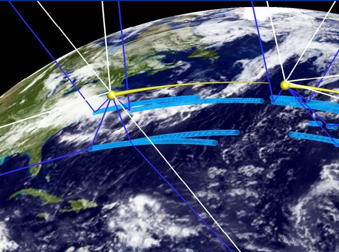
10 Deriving Coverage Mask (left) One of 2 nadir antenna patterns projected onto Earth (altitude 500 km, 60 o rotation, 28 o tilt) (center) SNR of received signal (10 m/s WS, 45 o inc. angle) (right) +8 db SNR contour with both antennas (meets WS retrieval uncertainty requirement) 10


11 90 min (one orbit) coverage showing all specular reflection contacts by each of 8 s/c 24 hr coverage provides nearly gap free spatial sampling within +/- 35 deg orbit inclination CYGNSS Earth Coverage 11

12 CYGNSS Historical Storm Track Overlay 12
")

13 CYGNSS Revisit Time Requirement is 12 hr mean revisit Probability distribution of revisit time for all Earth samples within +/-35 o (solid) and for samples of historical storm tracks (dashed). Revisit stats derived from PDF demonstrate 4 hr mean storm revisit and ~9 hr to revisit 90% of all storms 13

14 Hurricane Overpass Case Study Time lapse simulation comparing CYGNSS and ASCAT coverage of Hurricane Frances just before landfall Snapshots of all samples taken in 3 hour intervals Hurricane inner core shown as large blue dot 14
 15")
15 CYGNSS Observatory (exploded view) 15
 Mass: 17.")
16 CYGNSS Observatory (1 of 8) Observatory Power: 48.8 W (EOL margin 30.3%) Comm: 1.25 Mbps S-Band (31% link margin) Mass: 17.6 kg Orbit Altitude: 500 km Inclination: 35 deg Launch 6 Oct


17 Complete Flight Segment with Deployment Module 17

18 For more information: 18
THE CYGNSS NANOSATELLITE CONSTELLATION HURRICANE MISSION
 SSTDM2014, International Workshop on Small Satellites andsensor Technology for Disaster Management THE CYGNSS NANOSATELLITE CONSTELLATION HURRICANE MISSION Chris Ruf (1), Scott Gleason (2), Zorana Jelenak
The NASA EV-2 Cyclone Global Navigation Satellite System (CYGNSS) Mission
 Mission") The NASA EV-2 Cyclone Global Navigation Satellite System (CYGNSS) Mission Chris Ruf University of Michigan AOSS Department Ann Arbor, MI 48109 734-764-6561 cruf@umich.edu Scott Gleason Concordia University
The NASA EV-2 Cyclone Global Navigation Satellite System (CYGNSS) Mission Chris Ruf University of Michigan AOSS Department Ann Arbor, MI 48109 734-764-6561 cruf@umich.edu Scott Gleason Concordia University
Relationship between temporal and spatial resolution for a constellation of GNSS-R satellites
 JOURNAL OF SELECTED TOPICS IN APPLIED EARTH OBSERVATIONS AND REMOTE SENSING, CYGNSS SPECIAL ISSUE, DOI 10.1109/JSTARS.2018.2833426 1 Relationship between temporal and spatial resolution for a constellation
Ocean Remote Sensing with Reflectometry: Current Status and Future Directions Keynote
 Ocean Remote Sensing with Reflectometry: Current Status and Future Directions Keynote James L. Garrison Purdue University, West Lafayette, USA 4th International Conference on GPS Radio Occultation (ICGPSRO2018)
The NASA CYGNSS Mission; A Pathfinder for GNSS Scatterometry Remote Sensing Applications Randy Rose *11, Scott Gleason 1, Chris Ruf 2
 The NASA CYGNSS Mission; A Pathfinder for GNSS Scatterometry Remote Sensing Applications Randy Rose *11, Scott Gleason 1, Chris Ruf 2 1 Southwest Research Institute 2 University of Michigan ABSTRACT Global
The NASA EV-2 Cyclone Global Navigation Satellite System (CYGNSS) Mission
 Mission") The NASA EV2 Cyclone Global Navigation Satellite System (CYGNSS) Mission Chris Ruf University of Michigan AOSS Department Ann Arbor, MI 48109 7347646561 cruf@umich.edu Scott Gleason Concordia University
The NASA EV2 Cyclone Global Navigation Satellite System (CYGNSS) Mission Chris Ruf University of Michigan AOSS Department Ann Arbor, MI 48109 7347646561 cruf@umich.edu Scott Gleason Concordia University
P1.6 Simulation of the impact of new aircraft and satellite-based ocean surface wind measurements on H*Wind analyses
 P1.6 Simulation of the impact of new aircraft and satellite-based ocean surface wind measurements on H*Wind analyses Timothy L. Miller 1, R. Atlas 2, P. G. Black 3, J. L. Case 4, S. S. Chen 5, R. E. Hood
Current and Upcoming NASA Hurricane Measurement Missions National Hurricane Conference
 NASA Science Mission Directorate Earth Science Division Applied Sciences Program Current and Upcoming NASA Hurricane Measurement Missions National Hurricane Conference April 18, 2017 Formulation Implementation
Assessing the impact of assimilating CYGNSS ocean surface winds on tropical cyclone analyses and forecasts with regional OSSEs
 7A.6 Assessing the impact of assimilating CYGNSS ocean surface winds on tropical cyclone analyses and forecasts with regional OSSEs Shixuan Zhang * and Zhaoxia Pu Department of Atmospheric Sciences, University
Nanosat Technology And Managed Risk; An Update Of The CYGNSS Microsatellite Constellation Mission Development
 SSC14-VI-4 Nanosat Technology And Managed Risk; An Update Of The CYGNSS Microsatellite Constellation Mission Development Randy Rose, Will Wells, Debi Rose Southwest Research Institute 6220 Culebra Rd,
IMPROVED MICROWAVE REMOTE SENSING OF HURRICANE WIND SPEED AND RAIN RATES USING THE HURRICANE IMAGING RADIOMETER (HIRAD)
") IMPROVED MICROWAVE REMOTE SENSING OF HURRICANE WIND SPEED AND RAIN RATES USING THE HURRICANE IMAGING RADIOMETER (HIRAD) Salem F. El-Nimri*, Suleiman Al-Sweiss, Ruba A Christopher S. Ruf Amarin, W. Linwood
IMPROVED MICROWAVE REMOTE SENSING OF HURRICANE WIND SPEED AND RAIN RATES USING THE HURRICANE IMAGING RADIOMETER (HIRAD) Salem F. El-Nimri*, Suleiman Al-Sweiss, Ruba A Christopher S. Ruf Amarin, W. Linwood
SMAP Winds. Hurricane Irma Sep 5, AMS 33rd Conference on Hurricanes and Tropical Meteorology Ponte Vedra, Florida, 4/16 4/20, 2018
 Intensity and Size of Strong Tropical Cyclones in 2017 from NASA's SMAP L-Band Radiometer Thomas Meissner, Lucrezia Ricciardulli, Frank Wentz, Remote Sensing Systems, Santa Rosa, USA Charles Sampson, Naval
Preliminary evaluation of the impact of. cyclone assimilation and prediction
 Preliminary evaluation of the impact of the FORMOSAT 7R wind on tropical cyclone assimilation and prediction Shu Chih Yang 1,2, Cheng Chieh Kao 1,2, Wen Hao Yeh 3 and Stefani Huang 1 1 Dept. of Atmospheric
The Next Generation Polarimetric Airborne Doppler Radar
 The Next Generation Polarimetric Airborne Doppler Radar Wen Chau Lee, James Moore, J. Vivekanandan, Eric Loew, J. Salazar Peisang Tsai, and Vanda Grubišić National Center for Atmospheric Research* Boulder,
Review of GNSS as sources of opportunity for Earth Observation
 NOAA UK-MetOffice Joofix Review of GNSS as sources of opportunity for Earth Observation Dr. Estel Cardellach (ICE-CSIC/IEEC, Spain) HISDESAT ESA Overview Motivation: contribution to a sustained and efficient
Tropical Cyclone Mesoscale Data Assimilation
 Tropical Cyclone Mesoscale Data Assimilation Sharan Majumdar (RSMAS / U. Miami) Chris Velden (CIMSS / U. Wisconsin) Acknowledgments: Ryan Torn (SUNY at Albany), Altug Aksoy and Tomislava Vukicevic (NOAA/AOML/HRD)
Ocean Vector Winds in Storms from the SMAP L-Band Radiometer
 International Workshop on Measuring High Wind Speeds over the Ocean 15 17 November 2016 UK Met Office, Exeter Ocean Vector Winds in Storms from the SMAP L-Band Radiometer Thomas Meissner, Lucrezia Ricciardulli,
Vicky Chu, Jer Ling, Tom Lin, Joe Fong, Feng-Tai Huang, Guey-Shin Chang. April 15, 2011
 FORMOSAT-7/COSMIC-2 Overview Vicky Chu, Jer Ling, Tom Lin, Joe Fong, Feng-Tai Huang, Guey-Shin Chang April 15, 2011 Program Status AIT-TECRO Agreement on FORMOSAT-7/COSMIC-2 joint program has been signed
Project CyMISS Tropical Cyclone Measurements from the ISS
 Project CyMISS Tropical Cyclone Measurements from the ISS A.T. Stair, Paul Joss, Andrew LePage, John DeVore and Paul Pauliukonis And Joe Kristl, SDL/USU Visidyne, Inc (ats@visidyne.com) 1 Acronyms and
Earth Exploration-Satellite Service (EESS)- Active Spaceborne Remote Sensing and Operations
- Active Spaceborne Remote Sensing and Operations") Earth Exploration-Satellite Service (EESS)- Active Spaceborne Remote Sensing and Operations SRTM Radarsat JASON Seawinds TRMM Cloudsat Bryan Huneycutt (USA) Charles Wende (USA) WMO, Geneva, Switzerland
Earth Exploration-Satellite Service (EESS)- Active Spaceborne Remote Sensing and Operations SRTM Radarsat JASON Seawinds TRMM Cloudsat Bryan Huneycutt (USA) Charles Wende (USA) WMO, Geneva, Switzerland
Meeting the Needs for Satellite OVW
 Meeting the Needs for Satellite OVW NEED Multiple scatterometers to extend the coverage of QuikSCAT and provide continuity UNDERWAY EUMETSAT ASCAT on METOP series 1 st is in orbit ISRO Oceansat-2 Timely
Texas Alliance of Groundwater Districts Annual Summit
 Texas Alliance of Groundwater Districts Annual Summit Using Remote-Sensed Data to Improve Recharge Estimates August 28, 2018 by Ronald T. Green1, Ph.D., P.G. and Stu Stothoff2, Ph.D., P.G. Earth Science
The Green-OAWL (GrOAWL) Airborne Demonstrator for the ATHENA-OAWL Mission Concept: System Progress and Flight Plans
 Airborne Demonstrator for the ATHENA-OAWL Mission Concept: System Progress and Flight Plans") The Green-OAWL (GrOAWL) Airborne Demonstrator for the ATHENA-OAWL Mission Concept: System Progress and Flight Plans International Winds Working Group Workshop 27 June 1 July 2016 Monterey, CA Sara Tucker
The Green-OAWL (GrOAWL) Airborne Demonstrator for the ATHENA-OAWL Mission Concept: System Progress and Flight Plans International Winds Working Group Workshop 27 June 1 July 2016 Monterey, CA Sara Tucker
NOAA/NESDIS Tropical Web Page with LEO Satellite Products and Applications for Forecasters
 NOAA/NESDIS Tropical Web Page with LEO Satellite Products and Applications for Forecasters Sheldon Kusselson National Oceanic and Atmospheric Administration (NOAA) National Environmental Satellite Data
NASA Operating Missions
 NASA WGCV38 Update K. Thome Based on charts from M. Freilich, H. Maring, B. Markham, S. Volz Earth Science Division, Science Mission Directorate September 2014 NASA Operating Missions Feb. 2013 Feb. 2014
Megha-Tropiques Presentation by Indian Delegation at the 55th Session of UNCOPUOS Vienna 12 June 2012
 Megha-Tropiques Presentation by Indian Delegation at the 55 th Session of UNCOPUOS Vienna 12 June 2012 Megha-Tropiques Mission Indo-French Joint Satellite for studying tropical atmosphere Megha in Sanskrit
Q-Winds satellite hurricane wind retrievals and H*Wind comparisons
 Q-Winds satellite hurricane wind retrievals and H*Wind comparisons Pet Laupattarakasem and W. Linwood Jones Central Florida Remote Sensing Laboratory University of Central Florida Orlando, Florida 3816-
Objectives for meeting
 Objectives for meeting 1) Summarize planned experiments 2) Discuss resource availability Aircraft Instrumentation Expendables 3) Assign working groups to complete each experiment plan Flight planning and
The Properties of Convective Clouds Over the Western Pacific and Their Relationship to the Environment of Tropical Cyclones
 The Properties of Convective Clouds Over the Western Pacific and Their Relationship to the Environment of Tropical Cyclones Principal Investigator: Dr. Zhaoxia Pu Department of Meteorology, University
Zorana Jelenak Paul S. Chang Khalil Ahmed (OPC) Seubson Soisuvarn Qi Zhu NOAA/NESDIS/STAR-UCAR
 Seubson Soisuvarn Qi Zhu NOAA/NESDIS/STAR-UCAR") Near Real Time ASCAT Wind Vectors at NOAA and High Wind Issue Zorana Jelenak Paul S. Chang Khalil Ahmed (OPC) Seubson Soisuvarn Qi Zhu NOAA/NESDIS/STAR-UCAR ASCAT Wind Processing Implemented at NOAA Feb
Near Real Time ASCAT Wind Vectors at NOAA and High Wind Issue Zorana Jelenak Paul S. Chang Khalil Ahmed (OPC) Seubson Soisuvarn Qi Zhu NOAA/NESDIS/STAR-UCAR ASCAT Wind Processing Implemented at NOAA Feb
Future Opportunities of Using Microwave Data from Small Satellites for Monitoring and Predicting Severe Storms
 Future Opportunities of Using Microwave Data from Small Satellites for Monitoring and Predicting Severe Storms Fuzhong Weng Environmental Model and Data Optima Inc., Laurel, MD 21 st International TOV
Spaceborne Atmospheric Boundary Layer Explorer (SABLE)
") Spaceborne Atmospheric Boundary Layer Explorer (SABLE) Earth Venture-2 mission proposal Proposed SABLE objective: Measure cloud top heights and cloud top winds to quantify and map cloud-top entrainment
Spaceborne Atmospheric Boundary Layer Explorer (SABLE) Earth Venture-2 mission proposal Proposed SABLE objective: Measure cloud top heights and cloud top winds to quantify and map cloud-top entrainment
Title: The Impact of Convection on the Transport and Redistribution of Dust Aerosols
 Authors: Kathryn Sauter, Tristan L'Ecuyer Title: The Impact of Convection on the Transport and Redistribution of Dust Aerosols Type of Presentation: Oral Short Abstract: The distribution of mineral dust
How does NASA study hurricanes? 17 August 2015, by Max Gleber
 How does NASA study hurricanes? 17 August 2015, by Max Gleber Hurricanes are the most powerful weather event on Earth. NASA's expertise in space and scientific exploration contributes to essential services
Development of Spaceborne Dualfrequency. and Its Role for the Global Precipitation Measurement
 Development of Spaceborne Dualfrequency Precipitation Radar and Its Role for the Global Precipitation Measurement Shinsuke Satoh (1), Riko Oki (1), Nobuhiro Takahashi (2), and Toshio Iguchi (2) (1) National
Remote Sensing of Ocean Winds
 Remote Sensing of Ocean Winds Stephen Frasier Dept. of Electrical and Computer Engineering Offshore Wind Energy IGERT Seminar 3/5/2015 Remote Sensing of Wind For wind energy applications: Wind Profilers
WindSat Ocean Surface Emissivity Dependence on Wind Speed in Tropical Cyclones. Amanda Mims University of Michigan, Ann Arbor, MI
 WindSat Ocean Surface Emissivity Dependence on Wind Speed in Tropical Cyclones Amanda Mims University of Michigan, Ann Arbor, MI Abstract Radiometers are adept at retrieving near surface ocean wind vectors.
Tropical Cyclone Observa2ons with Aircra7 Passive and Ac2ve Microwave Instruments
 Tropical Cyclone Observa2ons with Aircra7 Passive and Ac2ve Microwave Instruments Paul Chang and Zorana Jelenak, NOAA/NESDIS/STAR James Carswell, Remote Sensing Solu2ons Stephen Frasier, University of
Rain Effects on Scatterometer Systems A summary of what is known to date
 Rain Effects on Scatterometer Systems A summary of what is known to date Kyle Hilburn, Deborah K Smith, *Frank J. Wentz Remote Sensing Systems NASA Ocean Vector Wind Science Team Meeting May 18-20, 2009
Satellite communications and the environment of space. V 1.1 Swiss Space Summer Camp 2016 Images: NASA 1
 Satellite communications and the environment of space Swiss Space Summer Camp 2016 Images: NASA 1 Can you name these satellites? Sputnik The first man made satellite Launched in 1957 by The USSR Mass 84kg,
3D.6 ESTIMATES OF HURRICANE WIND SPEED MEASUREMENT ACCURACY USING THE AIRBORNE HURRICANE IMAGING RADIOMETER
 3D.6 ESTIMATES OF HURRICANE WIND SPEED MEASUREMENT ACCURACY USING THE AIRBORNE HURRICANE IMAGING RADIOMETER Ruba A. Amarin *, Linwood Jones 1, James Johnson 1, Christopher Ruf 2, Timothy Miller 3 and Shuyi
Orbit Design Marcelo Suárez. 6th Science Meeting; Seattle, WA, USA July 2010
 Orbit Design Marcelo Suárez Orbit Design Requirements The following Science Requirements provided drivers for Orbit Design: Global Coverage: the entire extent (100%) of the ice-free ocean surface to at
Quantifying the Role of Tropospheric Relative Humidity on the Development of Tropical Cyclones
 Quantifying the Role of Tropospheric Relative Humidity on the Development of Tropical Cyclones 1 R., 2 B. Ríos-Berríos Tang and S. S. 1University of Puerto Rico at Mayagüez 1Significant Opportunities in
NHC Ocean Vector Winds Update
 NHC Ocean Vector Winds Update Michael J. Brennan NOAA/NWS/NCEP National Hurricane Center International Ocean Vector Winds Science Team Meeting Portland, Oregon, 20 May 2015 Current Status NHC is currently
NASA Future Magnetospheric Missions. J. Slavin & T. Moore Laboratory for Solar & Space Physics NASA GSFC
 NASA Future Magnetospheric Missions J. Slavin & T. Moore Laboratory for Solar & Space Physics NASA GSFC Future Magnetospheric Missions Strategic Missions Radiation Belt Storm Probes (LWS/2011) Magnetospheric
A two-season impact study of the Navy s WindSat surface wind retrievals in the NCEP global data assimilation system
 A two-season impact study of the Navy s WindSat surface wind retrievals in the NCEP global data assimilation system Li Bi James Jung John Le Marshall 16 April 2008 Outline WindSat overview and working
Optimizing observations and observing strategies to better evaluate and improve model physical processes
 Optimizing observations and observing strategies to better evaluate and improve model physical processes Joseph Cione HFIP telecon 22 October 2014 Motivation Overarching Objective Improve forecast performance
A Regional Microsatellite Constellation with Electric Propulsion In Support of Tuscan Agriculture
 Berlin, 20 th - 24 th 2015 University of Pisa 10 th IAA Symposium on Small Satellites for Earth Observation Student Conference A Regional Microsatellite Constellation with Electric Propulsion In Support
Remote sensing of precipitation extremes
 The panel is about: Understanding and predicting weather and climate extreme Remote sensing of precipitation extremes Climate extreme : (JSC meeting, June 30 2014) IPCC SREX report (2012): Climate Ali
Orbit and Transmit Characteristics of the CloudSat Cloud Profiling Radar (CPR) JPL Document No. D-29695
 JPL Document No. D-29695") Orbit and Transmit Characteristics of the CloudSat Cloud Profiling Radar (CPR) JPL Document No. D-29695 Jet Propulsion Laboratory California Institute of Technology Pasadena, CA 91109 26 July 2004 Revised
Orbit and Transmit Characteristics of the CloudSat Cloud Profiling Radar (CPR) JPL Document No. D-29695 Jet Propulsion Laboratory California Institute of Technology Pasadena, CA 91109 26 July 2004 Revised
P1.23 HISTOGRAM MATCHING OF ASMR-E AND TMI BRIGHTNESS TEMPERATURES
 P1.23 HISTOGRAM MATCHING OF ASMR-E AND TMI BRIGHTNESS TEMPERATURES Thomas A. Jones* and Daniel J. Cecil Department of Atmospheric Science University of Alabama in Huntsville Huntsville, AL 1. Introduction
esa ACE+ An Atmosphere and Climate Explorer based on GPS, GALILEO, and LEO-LEO Occultation Per Høeg (AIR/DMI) Gottfried Kirchengast (IGAM/UG)
 Gottfried Kirchengast (IGAM/UG)") ACE+ An Atmosphere and Climate Explorer based on GPS, GALILEO, and LEO-LEO Occultation Per Høeg (AIR/DMI) Gottfried Kirchengast (IGAM/UG) OPAC-1, September, 2002 1 Objectives Climate Monitoring global
ACE+ An Atmosphere and Climate Explorer based on GPS, GALILEO, and LEO-LEO Occultation Per Høeg (AIR/DMI) Gottfried Kirchengast (IGAM/UG) OPAC-1, September, 2002 1 Objectives Climate Monitoring global
NOAA Satellite & Information Service (NESDIS)
") Transition from Research to Operation for GNSS Radio Occultation Abigail D. Harper National Environmental Satellite, Data, and Information Service (NESDIS) Deputy Assistant Administrator, Systems April
Transition from Research to Operation for GNSS Radio Occultation Abigail D. Harper National Environmental Satellite, Data, and Information Service (NESDIS) Deputy Assistant Administrator, Systems April
Hurricane Structure: Theory and Diagnosis
 Hurricane Structure: Theory and Diagnosis 7 March, 2016 World Meteorological Organization Workshop Chris Landsea Chris.Landsea@noaa.gov National Hurricane Center, Miami Outline Structure of Hurricanes
Atmospheric Lidar The Atmospheric Lidar (ATLID) is a high-spectral resolution lidar and will be the first of its type to be flown in space.
 is a high-spectral resolution lidar and will be the first of its type to be flown in space.") www.esa.int EarthCARE mission instruments ESA s EarthCARE satellite payload comprises four instruments: the Atmospheric Lidar, the Cloud Profiling Radar, the Multi-Spectral Imager and the Broad-Band Radiometer.
www.esa.int EarthCARE mission instruments ESA s EarthCARE satellite payload comprises four instruments: the Atmospheric Lidar, the Cloud Profiling Radar, the Multi-Spectral Imager and the Broad-Band Radiometer.
SSC13-VI-1 MISSION DESIGN CONCEPT
 SSC13-VI-1 INTRODUCTION TO FORMOSAT-7/COSMIC-2 MISSION Alex da Silva Curiel, Meryl Lambert, Doug Liddle, Prof Sir Martin Sweeting. Surrey Satellite Technology Ltd. Tycho House, Surrey Research Park, ;
ON COMBINING AMSU AND POLAR MM5 OUTPUTS TO DETECT PRECIPITATING CLOUDS OVER ANTARCTICA
 ON COMBINING AMSU AND POLAR MM5 OUTPUTS TO DETECT PRECIPITATING CLOUDS OVER ANTARCTICA Stefano Dietrich, Francesco Di Paola, Elena Santorelli (CNR-ISAC, Roma, Italy) 2nd Antarctic Meteorological Observation,
Satellite Position Determination of LEO Spacecraft
 Satellite Position Determination of LEO Spacecraft S.C.Rathnakara ISRO Satellite Centre 5 th September, 2007 International Committee on Global Navigation Satellite Systems(ICG) Things to follow Brief background
Aircraft Observations of Tropical Cyclones. Robert Rogers NOAA/AOML Hurricane Research Division Miami, FL
 Aircraft Observations of Tropical Cyclones Robert Rogers NOAA/AOML Hurricane Research Division Miami, FL 1 Motivation Why are observations important? Many important physical processes within hurricanes
APPENDIX 2 OVERVIEW OF THE GLOBAL PRECIPITATION MEASUREMENT (GPM) AND THE TROPICAL RAINFALL MEASURING MISSION (TRMM) 2-1
 AND THE TROPICAL RAINFALL MEASURING MISSION (TRMM) 2-1") APPENDIX 2 OVERVIEW OF THE GLOBAL PRECIPITATION MEASUREMENT (GPM) AND THE TROPICAL RAINFALL MEASURING MISSION (TRMM) 2-1 1. Introduction Precipitation is one of most important environmental parameters.
APPENDIX 2 OVERVIEW OF THE GLOBAL PRECIPITATION MEASUREMENT (GPM) AND THE TROPICAL RAINFALL MEASURING MISSION (TRMM) 2-1 1. Introduction Precipitation is one of most important environmental parameters.
J16.1 PRELIMINARY ASSESSMENT OF ASCAT OCEAN SURFACE VECTOR WIND (OSVW) RETRIEVALS AT NOAA OCEAN PREDICTION CENTER
 RETRIEVALS AT NOAA OCEAN PREDICTION CENTER") J16.1 PRELIMINARY ASSESSMENT OF ASCAT OCEAN SURFACE VECTOR WIND (OSVW) RETRIEVALS AT NOAA OCEAN PREDICTION CENTER Khalil. A. Ahmad* PSGS/NOAA/NESDIS/StAR, Camp Springs, MD Joseph Sienkiewicz NOAA/NWS/NCEP/OPC,
J16.1 PRELIMINARY ASSESSMENT OF ASCAT OCEAN SURFACE VECTOR WIND (OSVW) RETRIEVALS AT NOAA OCEAN PREDICTION CENTER Khalil. A. Ahmad* PSGS/NOAA/NESDIS/StAR, Camp Springs, MD Joseph Sienkiewicz NOAA/NWS/NCEP/OPC,
10D.2 Methods for Introducing Vortical Hot Tower Heating in Numerical Models: Retrieving Latent Heat
 10D.2 Methods for Introducing Vortical Hot Tower Heating in Numerical Models: Retrieving Latent Heat Stephen R. Guimond Florida State University, Department of Meteorology and Center for Ocean-Atmospheric
University of Miami/RSMAS
 Observing System Simulation Experiments to Evaluate the Potential Impact of Proposed Observing Systems on Hurricane Prediction: R. Atlas, T. Vukicevic, L.Bucci, B. Annane, A. Aksoy, NOAA Atlantic Oceanographic
Airborne Studies of High Wind and Rain Effects Using IWRAP
 Airborne Studies of High Wind and Rain Effects Using IWRAP Robert F. Contreras, Stephen J. Frasier, and Tao Chu OVWST Meeting July 5-7, 2006 Salt Lake City, Utah Department of Electrical & Computer Engineering
Remote Sensing I: Basics
 Remote Sensing I: Basics Kelly M. Brunt Earth System Science Interdisciplinary Center, University of Maryland Cryospheric Science Laboratory, Goddard Space Flight Center kelly.m.brunt@nasa.gov (Based on
7.4 GPS-Based Measurements of Ocean Surface Roughness. Stephen J. Katzberg NASA Langley Research Center Hampton, VA 23681
 7.4 GPS-Based Measurements of Ocean Surface Roughness Stephen J. Katzberg NASA Langley Research Center Hampton, VA 3681 1. INTRODUCTION: Recent results have shown that the GPS reflection technique can
Application of Radio Occultation Data in Analyses and Forecasts of Tropical Cyclones Using an Ensemble Assimilation System
 Application of Radio Occultation Data in Analyses and Forecasts of Tropical Cyclones Using an Assimilation System Hui Liu, Jeff Anderson, and Bill Kuo NCAR Acknowledgment: C. Snyder, Y. Chen, T. Hoar,
Synthetic Weather Radar: Offshore Precipitation Capability
 Synthetic Weather Radar: Offshore Precipitation Capability Mark S. Veillette 5 December 2017 Sponsors: Randy Bass, FAA ANG-C6 and Rogan Flowers, FAA AJM-33 DISTRIBUTION STATEMENT A: Approved for public
ASCAT NRT Data Processing and Distribution at NOAA/NESDIS
 ASCAT NRT Data Processing and Distribution at NOAA/NESDIS Paul S. Chang, Zorana Jelenak, Seubson Soisuvarn, Qi Zhu Gene Legg and Jeff Augenbaum National Oceanic and Atmospheric Administration (NOAA) National
Characterizing the Structure of Hurricane Karl (2010): Doppler Radar and WRF
: Doppler Radar and WRF") Characterizing the Structure of Hurricane Karl (2010): Doppler Radar and WRF Jennifer DeHart and Robert Houze Atmospheric Physics and Chemistry Seminar 5.9.16 NASA grants: NNX13AG71G / NNX12AJ82G Orographic
Characterizing the Structure of Hurricane Karl (2010): Doppler Radar and WRF Jennifer DeHart and Robert Houze Atmospheric Physics and Chemistry Seminar 5.9.16 NASA grants: NNX13AG71G / NNX12AJ82G Orographic
A Time-varying Radiometric Bias Correction for the TRMM Microwave Imager. Kaushik Gopalan Thesis defense : Oct 29, 2008
 A Time-varying Radiometric Bias Correction for the TRMM Microwave Imager Kaushik Gopalan Thesis defense : Oct 29, 2008 Outline Dissertation Objective Initial research Introduction to GPM and ICWG Inter-satellite
Improved Microwave Radiometric Imaging of Surface Wind Speed Dynamics in the Hurricane Eye-Wall
 Improved Microwave Radiometric Imaging of Surface Wind Speed Dynamics in the Hurricane -Wall Ruba Amarin, W. Linwood Jones Christopher Ruf Shuyi Chen Central Florida Remote Sensing Lab. Space Physics Research
Emerging Needs and Opportunities in Ocean Remote Sensing
 Emerging Needs and Opportunities in Ocean Remote Sensing Christine Gommenginger National Oceanography Centre, Southampton With thanks to: Chris Banks, Val Byfield, Paolo Cipollini, Nadim Dayoub, Giuseppe
ESCI 110: 2 s.h. Introduction to Earth Sciences Programs ESCI 322: 3 s.h. Environmental Hydrology ESCI 241: 4 s.h. Meteorology (G2, L)
") ESCI 110: 2 s.h. Introduction to Earth Sciences Programs General introduction to each of the earth sciences disciplines and to college life. 2 hrs. lec. Offered in fall. Restricted to earth sciences majors.
ESCI 110: 2 s.h. Introduction to Earth Sciences Programs General introduction to each of the earth sciences disciplines and to college life. 2 hrs. lec. Offered in fall. Restricted to earth sciences majors.
Simulation Results of Alternative Methods for Formation Separation Control
 Simulation Results of Alternative Methods for Formation Separation Control Thomas Heine, Charles Bussy-Virat, Mark Moldwin, Aaron Ridley Department of Climate and Space Sciences and Engineering University
CHAPTER 2 VALIDATION OF RAIN RATE ESTIMATION IN HURRICANES FROM THE STEPPED FRQUENCY MICROWAVE RADIOMETER (SFMR)
") CHAPTER 2 VALIDATION OF RAIN RATE ESTIMATION IN HURRICANES FROM THE STEPPED FRQUENCY MICROWAVE RADIOMETER (SFMR) ALGORITHM CORRECTION AND ERROR ANALYSIS 2.1 Abstract Simultaneous observations by the Lower
CHAPTER 2 VALIDATION OF RAIN RATE ESTIMATION IN HURRICANES FROM THE STEPPED FRQUENCY MICROWAVE RADIOMETER (SFMR) ALGORITHM CORRECTION AND ERROR ANALYSIS 2.1 Abstract Simultaneous observations by the Lower
Unmanned Aerial Systems
 Unmanned Aerial Systems Gulf Region Stakeholder Workshop July 17-18, 2007 Mississippi State University Starkville, Mississippi List of Measurement Requirements Fill gaps in measurements of surface and
Observing System Simulation Experiments (OSSEs) with Radio Occultation observations
 with Radio Occultation observations") Observing System Simulation Experiments (OSSEs) with Radio Occultation observations Lidia Cucurull Deputy Director, NOAA Quantitative Observing System Assessment Program (QOSAP) NOAA OAR Principal Investigator
Observing System Simulation Experiments (OSSEs) with Radio Occultation observations Lidia Cucurull Deputy Director, NOAA Quantitative Observing System Assessment Program (QOSAP) NOAA OAR Principal Investigator
Equatorial and Low Latitude Scintillation Initiated From Low Altitude Forcing via Hurricanes/Typhoons
 Equatorial and Low Latitude Scintillation Initiated From Low Altitude Forcing via Hurricanes/Typhoons Dr. Rebecca Bishop The Aerospace Corporation PSL/SSAL 30 March 2012 The Aerospace Corporation 2012
EPIC2001 was conceived as an intensive process study along and near 95 o W during September and October 2001 used to make measurements of the atmosphe
 EPIC2001 was conceived as an intensive process study along and near 95 o W during September and October 2001 used to make measurements of the atmosphere and ocean in this region. Two aircraft, the National
S. L. Durden and S. Tanelli Jet Propulsion Laboratory California Institute of Technology 4800 Oak Grove Dr., Pasadena, CA 91109, USA
 Progress In Electromagnetics Research Letters, Vol. 8, 115 124, 2009 APPLICATION OF CLUTTER SUPPRESSION METHODS TO A GEOSTATIONARY WEATHER RADAR CONCEPT S. L. Durden and S. Tanelli Jet Propulsion Laboratory
JTWC's Use of TRMM in Typhoon Forecast Operations
 Use of TRMM in Typhoon Forecast Operations JTWC's Use of TRMM in Typhoon Forecast Operations Slide 1/24 Use of TRMM in Typhoon Forecast Operations Slide 2/24 Opening Comments The current microwave satellite
The ICESat 2 Mission Laser altimetry of ice, clouds and land elevation
 OSTM SWT San Diego October 2011 The ICESat 2 Mission Laser altimetry of ice, clouds and land elevation and also ocean, coastal, and continental waters Charon Birkett, ESSIC/UMD on behalf of T. Markus,
Development of the Next Generation GRAS Instrument
 Development of the Next Generation GRAS Instrument Jacob Christensen Magnus Bonnedal, Anders Carlström, Thomas Lindgren Sean Healy (ECMWF), Hans-Henrik Benzon (DMI) RUAG Space Gothenburg Sweden D-I-HO-00022-RSE,
Myung-Sook Park, Russell L. Elsberry and Michael M. Bell. Department of Meteorology, Naval Postgraduate School, Monterey, California, USA
 Latent heating rate profiles at different tropical cyclone stages during 2008 Tropical Cyclone Structure experiment: Comparison of ELDORA and TRMM PR retrievals Myung-Sook Park, Russell L. Elsberry and
Understanding the Microphysical Properties of Developing Cloud Clusters during TCS-08
 DISTRIBUTION STATEMENT A: Approved for public release; distribution is unlimited. Understanding the Microphysical Properties of Developing Cloud Clusters during TCS-08 PI: Elizabeth A. Ritchie Department
Lecture 4b: Meteorological Satellites and Instruments. Acknowledgement: Dr. S. Kidder at Colorado State Univ.
 Lecture 4b: Meteorological Satellites and Instruments Acknowledgement: Dr. S. Kidder at Colorado State Univ. US Geostationary satellites - GOES (Geostationary Operational Environmental Satellites) US
Using Data Assimilation to Explore Precipitation - Cloud System - Environment Interactions
 Using Data Assimilation to Explore Precipitation - Cloud System - Environment Interactions Derek J. Posselt Collaborators: Samantha Tushaus, Richard Rotunno, Marcello Miglietta, Craig Bishop, Marcus van
Coincident Observations with QuikSCAT and ASCAT of the Effects of Rain-Induced Sea Surface Stress During Hurricane Ike
 Coincident Observations with QuikSCAT and ASCAT of the Effects of Rain-Induced Sea Surface Stress During Hurricane Ike David E. Weissman Hofstra University Hempstead, New York 11549 Mark A. Bourassa Center
Inner core dynamics: Eyewall Replacement and hot towers
 Inner core dynamics: Eyewall Replacement and hot towers FIU Undergraduate Hurricane Internship Lecture 4 8/13/2012 Why inner core dynamics is important? Current TC intensity and structure forecasts contain
Wind Imaging Spectrometer and Humidity-sounder (WISH): a Practical and Effective NPOESS P3I Sensor
: a Practical and Effective NPOESS P3I Sensor") Wind Imaging Spectrometer and Humidity-sounder (WISH): a Practical and Effective NPOESS P3I Sensor Jeffery J. Puschell Raytheon Space and Airborne Systems Hung-Lung Huang University of Wisconsin, Madison
Wind Imaging Spectrometer and Humidity-sounder (WISH): a Practical and Effective NPOESS P3I Sensor Jeffery J. Puschell Raytheon Space and Airborne Systems Hung-Lung Huang University of Wisconsin, Madison
Ground-based Validation of spaceborne lidar measurements
 Ground-based Validation of spaceborne lidar measurements Ground-based Validation of spaceborne lidar measurements to make something officially acceptable or approved, to prove that something is correct
Effect of rain on Ku band fan beam Scatterometer
 Effect of rain on Ku band fan beam Scatterometer J. Tournadre, Y. Quilfen, B. Chapron Laboratoire d'océanographie Spatiale Ifremer Brest Problem/Drawback of the use of Ku-Band for radar SCAT on the future
A High-Quality Tropical Cyclone Reanalysis Dataset Using 4DVAR Data Assimilation Technique
 A High-Quality Tropical Cyclone Reanalysis Dataset Using 4DVAR Data Assimilation Technique Prof. Tim Li IPRC/University of Hawaii and Dr. Fuzhong Weng, Chief Sensor Physics Branch NOAA/NESDIS/Office of
16D.3 EYEWALL LIGHTNING OUTBREAKS AND TROPICAL CYCLONE INTENSITY CHANGE
 16D.3 EYEWALL LIGHTNING OUTBREAKS AND TROPICAL CYCLONE INTENSITY CHANGE Nicholas W. S. Demetriades and Ronald L. Holle Vaisala Inc., Tucson, Arizona, USA Steven Businger University of Hawaii Richard D.
IMPACT OF GROUND-BASED GPS PRECIPITABLE WATER VAPOR AND COSMIC GPS REFRACTIVITY PROFILE ON HURRICANE DEAN FORECAST. (a) (b) (c)
 (b) (c)") 9B.3 IMPACT OF GROUND-BASED GPS PRECIPITABLE WATER VAPOR AND COSMIC GPS REFRACTIVITY PROFILE ON HURRICANE DEAN FORECAST Tetsuya Iwabuchi *, J. J. Braun, and T. Van Hove UCAR, Boulder, Colorado 1. INTRODUCTION
9B.3 IMPACT OF GROUND-BASED GPS PRECIPITABLE WATER VAPOR AND COSMIC GPS REFRACTIVITY PROFILE ON HURRICANE DEAN FORECAST Tetsuya Iwabuchi *, J. J. Braun, and T. Van Hove UCAR, Boulder, Colorado 1. INTRODUCTION
3.7 COMPARISON OF INSTANTANEOUS TRMM SATELLITE AND GROUND VALIDATION RAIN RATE ESTIMATES
 3.7 COMPARISON OF INSTANTANEOUS TRMM SATELLITE AND GROUND VALIDATION RAIN RATE ESTIMATES David B. Wolff 1,2 Brad L. Fisher 1,2 1 NASA Goddard Space Flight Center, Greenbelt, Maryland 2 Science Systems
The NASA TROPICS CubeSat Constellation Mission: Overview and Science Objectives
 SSC17-VI-07 The NASA TROPICS CubeSat Constellation Mission: Overview and Science Objectives W. Blackwell, D. Burianek, K. Clark, D. Crompton, A. Cunningham, L. Fuhrman, P. Hopman, and S. Michael MIT Lincoln
Lecture 19: Operational Remote Sensing in Visible, IR, and Microwave Channels
 MET 4994 Remote Sensing: Radar and Satellite Meteorology MET 5994 Remote Sensing in Meteorology Lecture 19: Operational Remote Sensing in Visible, IR, and Microwave Channels Before you use data from any
Lecture 1d: Satellite Orbits
 Lecture 1d: Satellite Orbits Outline 1. Newton s Laws of Motion 2. Newton s Law of Universal Gravitation 3. Kepler s Laws 4. Putting Newton and Kepler s Laws together and applying them to the Earth-satellite