Remote Sensing of Ocean Winds
|
|
|
- Melvin Harrell
- 6 years ago
- Views:
Transcription

1 Remote Sensing of Ocean Winds Stephen Frasier Dept. of Electrical and Computer Engineering Offshore Wind Energy IGERT Seminar 3/5/2015


2 Remote Sensing of Wind For wind energy applications: Wind Profilers Radar: UHF frequency Sodar: audible Lidar: IR 2
3 Remote Sensing of Wind For wind energy applications: Wind Profilers Radar: UHF frequency Sodar: audible Lidar: IR Problematic over ocean 3
4 Remote Sensing of Wind For wind energy applications: Wind Profilers Radar: UHF frequency Sodar: audible Lidar: IR Problematic over ocean Platform required: buoy, mooring 4
5 Remote Sensing of Wind For wind energy applications: Wind Profilers Radar: UHF frequency Sodar: audible Lidar: IR Problematic over ocean Platform required: buoy, mooring Data retrieval, power constraints 5
6 Remote Sensing of Wind For wind energy applications: Wind Profilers Radar: UHF frequency Sodar: audible Lidar: IR Problematic over ocean Platform required: buoy, mooring Data retrieval, power constraints motion compensation, maintenance (salt) 6
7 Motivation Why measure global ocean winds? Input to global circulation models (GCMS) Numerical weather prediction (NWP) Wind and wave forecasting (shipping) Wind energy forecasting/climatology 7
8 Motivation How do we measure from space or aircraft? Radar scatterometers (active) Radiometers (passive) Measure sea-surface signature of wind Day/Night/All-weather operation 8
 9")
9 ISS Rapidscat Mission NASA's latest wind scatterometer deployed on the international space station (9/2014) 9

10 EU's Advanced Scatterometer 10
11 A Brief History NASA missions RadScat onskylab (1973) demonstration SASS on SeaSAT-A (1978) failed at 100 days NSCAT on ADEOS-1 ( ) solar panel failure SeaWinds on QuikSCAT ( ) rescue mission SeaWinds on ADEOS-2 ( ) solar panel failure RapidScat on ISS (2014- ) stopgap mission 11
12 A Brief History NASA missions RadScat onskylab (1973) demonstration SASS on SeaSAT-A (1978) failed at 100 days NSCAT on ADEOS-1 ( ) solar panel failure SeaWinds on QuikSCAT ( ) rescue mission SeaWinds on ADEOS-2 ( ) solar panel failure RapidScat on ISS (2014- ) stopgap mission ESA missions ERS-1 ( ), ERS-2 ( ) Envisat ( ) EUMetSat operational satellites ASCAT on METOP-A (2006- ), METOP-B (2013- ) OSCAT ( ): India 12
13 A Brief History NASA missions RadScat onskylab (1973) demonstration SASS on SeaSAT-A (1978) failed at 100 days NSCAT on ADEOS-1 ( ) solar panel failure SeaWinds on QuikSCAT ( ) rescue mission SeaWinds on ADEOS-2 ( ) solar panel failure RapidScat on ISS (2014- ) stopgap mission ESA missions ERS-1 ( ), ERS-2 ( ) Envisat ( ) EUMetSat operational satellites ASCAT on METOP-A (2006- ), METOP-B (2013- ) Other agency missions OSCAT ( ): India HY-2A (2011-): China 13
14 Radar echo from surface roughness Bragg Scattering Incident microwave radiation in resonance with short waves (dominant for 30 < < 70 ) B /(2sin( ~ 2cm (Ku-band) ; ~ 5cm (C-band) 14
15 Radar echo from surface roughness Courtesy Z.Jelenak 15

16 Radar echo from surface roughness Courtesy Z.Jelenak 16
17 Radar echo from surface roughness Courtesy Z.Jelenak 17

18 Radar echo from surface roughness Courtesy Z.Jelenak 18
19 Dependence on Wind and Incidence Angle Most sensitivity to wind at moderate incidence angles Courtesy Z.Jelenak 19


20 Dependence on Wind and Azimuth Angle Most sensitivity to wind dir. at moderate wind speeds 30m/s 25m/s 20m/s 15m/s 10m/s 5m/s 20 Z.Jelenak
")

 Dual")

21 Current Scatterometer Designs Fixed fan beam C-band (5 cm) VV-pol Sampling km Static antenna ASCAT, double swath Rotating pencil beam Ku-band (2 cm) Dual polarization Sampling km Rotating antenna Seawinds Courtesy Z.Jelenak 21
22 Near Real-Time Products 22
23 Microwave Radiometry Blackbody Radiation 23
24 Microwave Radiometry Blackbody Radiation Microwaves over here 24
25 Microwave Radiometry Blackbody Radiation Greybody Radiation P = k(et)b e = emissivity T = Temperature et = T B Brightness Temperature Microwaves over here 25
26 Microwave Radiative Transfer T B Observations: Surface properties Atmospheric properties Copyright 1996 Japan Association of Remote Sensing All rights reserved 26
27 Dependence on Wind Speed and Rain 27
28 Dependence on Wind Speed and Rain foam roughness 28
29 Ocean Wind Climatology from Satellite Liu et al., Wind power at sea as observed from space, ch 14 in Muyeen, S.M. (ed.), Wind Power, Intech, Vienna,

30 Ocean Wind Climatology from Satellite 30
31 Global Scatterometer Missions Launch Date 10/06 08 C-band /99 Ku-band QuikSCAT USA EPS SG Europe HY-2A China Combined C- and Ku-band Operating FY-3E with 2FS China Operational Series with 2FS India Approved Extended sw 24feb11 31

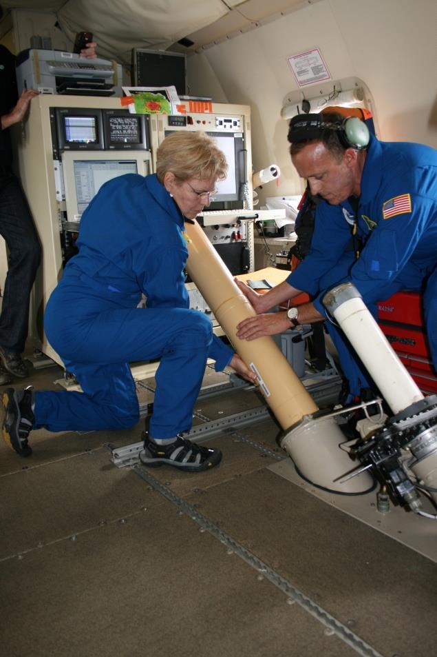
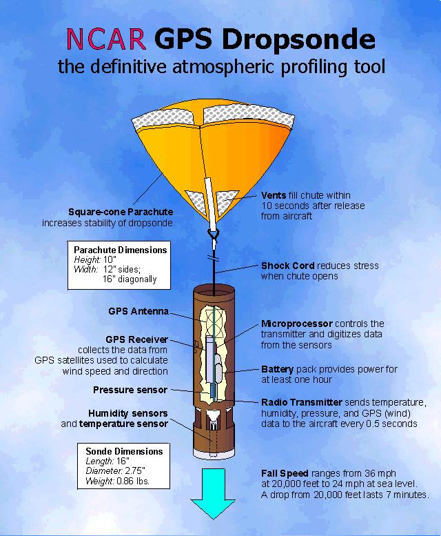
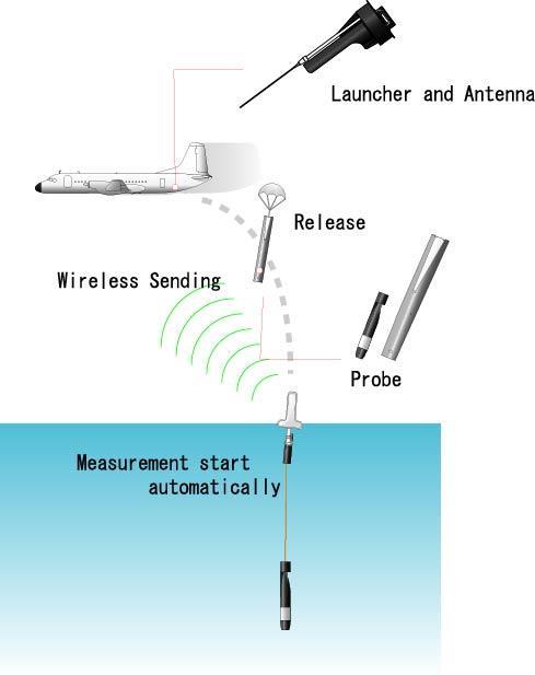
32 A Future Scatterometer Design Cyclone Global Navigation Satellite System (CYGNSS) 32

33 Scatterometry Issues Poor sensitivity in high winds Investigation polarizations Contamination by rain Attenuation through atm. Add'l surface roughening by drops and/or downdrafts Spatial smoothing Extreme events smaller than resolution 33
34 What do we do? Obtain scatterometer measurements in high-wind (and rain) regimes Hurricanes (typ. Aug-Oct) Based from Tampa, St. Croix, or Barbados High-latitude winter storms (Jan-Feb) Based from Anchorage, St. Johns, Halifax How does it work? 34
 Sold/maintained by Prosensing, Inc.")
35 Developed at NASA/UMass (C.T. Swift) Sold/maintained by Prosensing, Inc. Nicknamed the Smurf 35
36 Hurricane Reconnaisance 53 rd Weather Reconnaisance Squadron Based at Keesler AFB in Biloxi, Mississippi Provide operational reconnaisance for National Hurricane Center (NHC) in Miami, FL. Fly specialized (W)C-130 aircraft These are the guys on the TV show Hurricane Hunters NOAA Aircraft Operations Center Based at McDill AFB in Tampa, FL Do research reconnaisance for developing new observing techniques or studying storm structure. Fly specialized (W)P-3 aircraft. Periodically tasked by NHC for operational storm fixes. 36
37 Research Aircraft: Lockheed WP-3D 37

38 Research Aircraft: Lockheed WP-3D LF Weather Radar Microwave Radiometer SFMR Tail Doppler Radar 38


39 NOAA has 2 WP-3Ds: N43RF Miss Piggy 39
40 In the cockpit... Rabbit's foot 40

41 In the cockpit... Fuzzy dice Rabbit's foot 41
42 Aircraft Measurements Flight-level winds pressure Wind, temperature, humidity profiles via GPS dropsonde Winds & precipitation aloft via tail Doppler radar Surface-level winds via microwave radiometer & dropsonde Sea surface temperature Expendable bathythermographs Our measurements: Radar signature of sea-surface Precipitation between aircraft and sea-surface 42
43 Expendables XBT: expendable bathythermograph 43
44 Our Radar Imaging Wind & Rain Airborne Profiler 44


45 Our digs on the P-3 Radar electronics in the back Data recording up front 45

46 Tasked Mission on 10/17/

47 Tasked Mission on 10/17/
48 Tasked Mission on 10/17/2014 Eyewall 48
49 Tasked Mission on 10/17/ Leg 1 49

50 Radar view from the eye... 50

51 View from 8 kft just inside the eye... 51
52 Tasked Mission on 10/17/2014 High-Winds Research 52
53 Tasked Mission on 10/17/2014 I threw up about here... 53
54 Sample NRCS Observations 54
55 The End 55
56 Eye Transect of Hurricane Rita (Cat 5) 56
Q-Winds satellite hurricane wind retrievals and H*Wind comparisons
 Q-Winds satellite hurricane wind retrievals and H*Wind comparisons Pet Laupattarakasem and W. Linwood Jones Central Florida Remote Sensing Laboratory University of Central Florida Orlando, Florida 3816-
AWDP km. 25 km
 MyOcean2 Wind AWDP 1 12.5 km 25 km Tropical variability 1. Dry areas reasonable 2. NWP models lack airsea interaction in rainy areas 3. ASCAT scatterometer does a good job near rain 4. QuikScat, OSCAT
Q-Winds Hurricane Retrieval Algorithm using QuikSCAT Scatterometer
 Q-Winds Hurricane Retrieval Algorithm using QuikSCAT Scatterometer Pete Laupattarakasem Doctoral Dissertation Defense March 23 rd, 2009 Presentation Outline Dissertation Objective Background Scatterometry/Radiometry
URSI-F Microwave Signatures Meeting 2010, Florence, Italy, October 4 8, Thomas Meissner Lucrezia Ricciardulli Frank Wentz
 URSI-F Microwave Signatures Meeting 2010, Florence, Italy, October 4 8, 2010 Wind Measurements from Active and Passive Microwave Sensors High Winds and Winds in Rain Thomas Meissner Lucrezia Ricciardulli
EVALUATION OF WINDSAT SURFACE WIND DATA AND ITS IMPACT ON OCEAN SURFACE WIND ANALYSES AND NUMERICAL WEATHER PREDICTION
 5.8 EVALUATION OF WINDSAT SURFACE WIND DATA AND ITS IMPACT ON OCEAN SURFACE WIND ANALYSES AND NUMERICAL WEATHER PREDICTION Robert Atlas* NOAA/Atlantic Oceanographic and Meteorological Laboratory, Miami,
Aircraft Observations of Tropical Cyclones. Robert Rogers NOAA/AOML Hurricane Research Division Miami, FL
 Aircraft Observations of Tropical Cyclones Robert Rogers NOAA/AOML Hurricane Research Division Miami, FL 1 Motivation Why are observations important? Many important physical processes within hurricanes
Satellite Oceanography and Applications 2: Altimetry, scatterometry, SAR, GRACE. RMU Summer Program (AUGUST 24-28, 2015)
") Satellite Oceanography and Applications 2: Altimetry, scatterometry, SAR, GRACE RMU Summer Program (AUGUST 24-28, 2015) Altimetry 2 Basic principles of satellite altimetry Altimetry: the measurements of
Satellite Oceanography and Applications 2: Altimetry, scatterometry, SAR, GRACE RMU Summer Program (AUGUST 24-28, 2015) Altimetry 2 Basic principles of satellite altimetry Altimetry: the measurements of
SMAP Winds. Hurricane Irma Sep 5, AMS 33rd Conference on Hurricanes and Tropical Meteorology Ponte Vedra, Florida, 4/16 4/20, 2018
 Intensity and Size of Strong Tropical Cyclones in 2017 from NASA's SMAP L-Band Radiometer Thomas Meissner, Lucrezia Ricciardulli, Frank Wentz, Remote Sensing Systems, Santa Rosa, USA Charles Sampson, Naval
Programmatic Perspectives
 NOAA Programmatic Perspectives Stan Wilson NOAA Satellite & Information Service IOVW Science Team Meeting, Annapolis, 9-11 May 2011 1 NOAA Plans Beyond QuikSCAT NOAA has been pursuing two avenues to meet
Update on SCOPE-Nowcasting Pilot Project Real Time Ocean Products Suman Goyal Scientist-E
 Update on SCOPE-Nowcasting Pilot Project Real Time Ocean Products Suman Goyal Scientist-E 19-22 Nov 2013 SCOPE-Nowcasting-1 Agenda Item 5 Pilot Projects Overview Users /Clients User requirements Product
Progress in Calculating Tropical Cyclone Surface Wind Inflow from OVW Observations
 Progress in Calculating Tropical Cyclone Surface Wind Inflow from OVW Observations Ralph Foster, APL, University of Washington, Seattle, WA Jun Zhang, HRD, NOAA, Miami, FL Peter Black, Salinas, CA IOVWST
Zorana Jelenak Paul S. Chang Khalil Ahmed (OPC) Seubson Soisuvarn Qi Zhu NOAA/NESDIS/STAR-UCAR
 Seubson Soisuvarn Qi Zhu NOAA/NESDIS/STAR-UCAR") Near Real Time ASCAT Wind Vectors at NOAA and High Wind Issue Zorana Jelenak Paul S. Chang Khalil Ahmed (OPC) Seubson Soisuvarn Qi Zhu NOAA/NESDIS/STAR-UCAR ASCAT Wind Processing Implemented at NOAA Feb
Near Real Time ASCAT Wind Vectors at NOAA and High Wind Issue Zorana Jelenak Paul S. Chang Khalil Ahmed (OPC) Seubson Soisuvarn Qi Zhu NOAA/NESDIS/STAR-UCAR ASCAT Wind Processing Implemented at NOAA Feb
Ocean Vector Winds in Storms from the SMAP L-Band Radiometer
 International Workshop on Measuring High Wind Speeds over the Ocean 15 17 November 2016 UK Met Office, Exeter Ocean Vector Winds in Storms from the SMAP L-Band Radiometer Thomas Meissner, Lucrezia Ricciardulli,
Bringing Consistency into High Wind Measurements with Spaceborne Microwave Radiometers and Scatterometers
 International Ocean Vector Wind Science Team Meeting May 2-4, 2017, Scripps Bringing Consistency into High Wind Measurements with Spaceborne Microwave Radiometers and Scatterometers Thomas Meissner, Lucrezia
Rain Effects on Scatterometer Systems A summary of what is known to date
 Rain Effects on Scatterometer Systems A summary of what is known to date Kyle Hilburn, Deborah K Smith, *Frank J. Wentz Remote Sensing Systems NASA Ocean Vector Wind Science Team Meeting May 18-20, 2009
High Resolution Vector Wind Retrieval from SeaWinds Scatterometer Data
 High Resolution Vector Wind Retrieval from SeaWinds Scatterometer Data David G. Long Brigham Young University, 459 Clyde Building, Provo, UT 84602 long@ee.byu.edu http://www.scp.byu.edu Abstract The SeaWinds
Julia Figa-Saldaña & Klaus Scipal
 Julia Figa-Saldaña & Klaus Scipal julia.figa@eumetsat.int klaus.scipal@esa.int Meeting, Outline MetOp/EPS status MetOp/EPS Second Generation status 2016 scatterometer conference Other European ocean programme
J16.1 PRELIMINARY ASSESSMENT OF ASCAT OCEAN SURFACE VECTOR WIND (OSVW) RETRIEVALS AT NOAA OCEAN PREDICTION CENTER
 RETRIEVALS AT NOAA OCEAN PREDICTION CENTER") J16.1 PRELIMINARY ASSESSMENT OF ASCAT OCEAN SURFACE VECTOR WIND (OSVW) RETRIEVALS AT NOAA OCEAN PREDICTION CENTER Khalil. A. Ahmad* PSGS/NOAA/NESDIS/StAR, Camp Springs, MD Joseph Sienkiewicz NOAA/NWS/NCEP/OPC,
J16.1 PRELIMINARY ASSESSMENT OF ASCAT OCEAN SURFACE VECTOR WIND (OSVW) RETRIEVALS AT NOAA OCEAN PREDICTION CENTER Khalil. A. Ahmad* PSGS/NOAA/NESDIS/StAR, Camp Springs, MD Joseph Sienkiewicz NOAA/NWS/NCEP/OPC,
P1.6 Simulation of the impact of new aircraft and satellite-based ocean surface wind measurements on H*Wind analyses
 P1.6 Simulation of the impact of new aircraft and satellite-based ocean surface wind measurements on H*Wind analyses Timothy L. Miller 1, R. Atlas 2, P. G. Black 3, J. L. Case 4, S. S. Chen 5, R. E. Hood
Climate data records from OSI SAF scatterometer winds. Anton Verhoef Jos de Kloe Jeroen Verspeek Jur Vogelzang Ad Stoffelen
 Climate data records from OSI SAF scatterometer winds Anton Verhoef Jos de Kloe Jeroen Verspeek Jur Vogelzang Ad Stoffelen Outline Motivation Planning Preparation and methods Quality Monitoring Output
COMPARISON OF SATELLITE DERIVED OCEAN SURFACE WIND SPEEDS AND THEIR ERROR DUE TO PRECIPITATION
 COMPARISON OF SATELLITE DERIVED OCEAN SURFACE WIND SPEEDS AND THEIR ERROR DUE TO PRECIPITATION A.-M. Blechschmidt and H. Graßl Meteorological Institute, University of Hamburg, Hamburg, Germany ABSTRACT
Airborne Studies of High Wind and Rain Effects Using IWRAP
 Airborne Studies of High Wind and Rain Effects Using IWRAP Robert F. Contreras, Stephen J. Frasier, and Tao Chu OVWST Meeting July 5-7, 2006 Salt Lake City, Utah Department of Electrical & Computer Engineering
Meeting the Needs for Satellite OVW
 Meeting the Needs for Satellite OVW NEED Multiple scatterometers to extend the coverage of QuikSCAT and provide continuity UNDERWAY EUMETSAT ASCAT on METOP series 1 st is in orbit ISRO Oceansat-2 Timely
Ocean Vector Wind as Essential Climate Variable.
 Ocean Vector Wind as Essential Climate Variable Ad.Stoffelen@knmi.nl Context WCRP, World Climate Research Program WOAP, WCRP Observation Assimilation Panel GCOS, Global Climate Observing System Essential
WindSat Ocean Surface Emissivity Dependence on Wind Speed in Tropical Cyclones. Amanda Mims University of Michigan, Ann Arbor, MI
 WindSat Ocean Surface Emissivity Dependence on Wind Speed in Tropical Cyclones Amanda Mims University of Michigan, Ann Arbor, MI Abstract Radiometers are adept at retrieving near surface ocean wind vectors.
A - E R - E ON CLIMATE DATA RECORDS, TRENDS AND EXTREMES
 A - E R - E ON CLIMATE DATA RECORDS, TRENDS AND EXTREMES Ad Stoffelen, Anton Verhoef, Jeroen Verspeek, Jos de Kloe, Jur Vogelzang, Maria Belmonte : KNMI, the Netherlands Ana Trindade, Marcos Portabella
PREDICTION AND MONITORING OF OCEANIC DISASTERS USING MICROWAVE REMOTE SENSING TECHNIQUES
 PREDICTION AND MONITORING OF OCEANIC DISASTERS USING MICROWAVE REMOTE SENSING TECHNIQUES O P N Calla International Centre for Radio Science, OM NIWAS A-23, Shastri Nagar, Jodhpur-342 003 Abstract The disasters
How does NASA study hurricanes? 17 August 2015, by Max Gleber
 How does NASA study hurricanes? 17 August 2015, by Max Gleber Hurricanes are the most powerful weather event on Earth. NASA's expertise in space and scientific exploration contributes to essential services
GAP ANALYSIS FOR SATELLITE MISSIONS SUPPORTING THE GOS
 WMO OMM World Meteorological Organization Working together in weather, climate and water GAP ANALYSIS FOR SATELLITE MISSIONS SUPPORTING THE GOS CGMS-39 WMO-WP-31, Agenda item III.5 Dr B. Bizzarri, Consultant
REVISION OF THE STATEMENT OF GUIDANCE FOR GLOBAL NUMERICAL WEATHER PREDICTION. (Submitted by Dr. J. Eyre)
") WORLD METEOROLOGICAL ORGANIZATION Distr.: RESTRICTED CBS/OPAG-IOS (ODRRGOS-5)/Doc.5, Add.5 (11.VI.2002) COMMISSION FOR BASIC SYSTEMS OPEN PROGRAMME AREA GROUP ON INTEGRATED OBSERVING SYSTEMS ITEM: 4 EXPERT
WORLD METEOROLOGICAL ORGANIZATION Distr.: RESTRICTED CBS/OPAG-IOS (ODRRGOS-5)/Doc.5, Add.5 (11.VI.2002) COMMISSION FOR BASIC SYSTEMS OPEN PROGRAMME AREA GROUP ON INTEGRATED OBSERVING SYSTEMS ITEM: 4 EXPERT
RapidScat A New Measure of Ocean Winds
 Jet Propulsion Laboratory California Institute of Technology RapidScat A New Measure of Ocean Winds Stacey Boland Project Systems Engineer Howard J. Eisen Project Manager Ernesto Rodriguez Project Scientist
Corrections to Scatterometer Wind Vectors For Precipitation Effects: Using High Resolution NEXRAD and AMSR With Intercomparisons
 Corrections to Scatterometer Wind Vectors For Precipitation Effects: Using High Resolution NEXRAD and AMSR With Intercomparisons David E. Weissman Hofstra University Hempstead, New York 11549 Svetla Hristova-Veleva
Objectives for meeting
 Objectives for meeting 1) Summarize planned experiments 2) Discuss resource availability Aircraft Instrumentation Expendables 3) Assign working groups to complete each experiment plan Flight planning and
A NEW SAR RETRIEVAL METHOD FOR HURRICANE WIND PARAMETERS
 A NEW SAR RETRIEVAL METHOD FOR HURRICANE WIND PARAMETERS Antonio Reppucci, Susanne lehner, Johannes Schulz-Stellenfleth German Aerospace Center (DLR) Oberpfaffenhofen 82234 Wessling, Germany. Hurricane
Introduction. Recent changes in the use of AMV observations. AMVs over land. AMV impact study. Use of Scatterometer data (Ascat, Oceansat-2)
") Recent progress in using satellite winds at the German Weather Service Alexander Cress, Heinz Werner Bitzer German Weather Service, Offenbach am Main, Germany, email: Alexander.Cress@dwd.de Introduction
Recent progress in using satellite winds at the German Weather Service Alexander Cress, Heinz Werner Bitzer German Weather Service, Offenbach am Main, Germany, email: Alexander.Cress@dwd.de Introduction
ESTIMATION OF OCEANIC RAINFALL USING PASSIVE AND ACTIVE MEASUREMENTS FROM SEAWINDS SPACEBORNE MICROWAVE SENSOR KHALIL ALI AHMAD
 ESTIMATION OF OCEANIC RAINFALL USING PASSIVE AND ACTIVE MEASUREMENTS FROM SEAWINDS SPACEBORNE MICROWAVE SENSOR by KHALIL ALI AHMAD M.S. University of Central Florida, 2004 A dissertation submitted in partial
Radiometric Calibration of RapidScat Using the GPM Microwave Imager
 Proceedings Radiometric Calibration of RapidScat Using the GPM Microwave Imager Ali Al-Sabbagh *, Ruaa Alsabah and Josko Zec Department of Electrical and Computer Engineering, Florida Institute of Technology,
Calibration and Validation of the RapidScat Scatterometer Using Natural Land Targets
 Brigham Young University BYU ScholarsArchive All Theses and Dissertations 215-9-1 Calibration and Validation of the RapidScat Scatterometer Using Natural Land Targets Nathan Mark Madsen Brigham Young University
Specification of Tropical Cyclone Parameters From Aircraft Reconnaissance. Andrew Cox and Vincent Cardone Oceanweather Inc.
 Specification of Tropical Cyclone Parameters From Aircraft Reconnaissance Andrew Cox and Vincent Cardone Oceanweather Inc. Cos Cob, CT, USA Motivation This paper is part of on-going work to improve the
Integrating Multiple Scatterometer Observations into a Climate Data Record of Ocean Vector Winds
 Integrating Multiple Scatterometer Observations into a Climate Data Record of Ocean Vector Winds Lucrezia Ricciardulli and Frank Wentz Remote Sensing Systems, CA, USA E-mail: Ricciardulli@remss.com presented
OCEAN VECTOR WINDS IN STORMS FROM THE SMAP L-BAND RADIOMETER
 Proceedings for the 2016 EUMETSAT Meteorological Satellite Conference, 26-30 September 2016, Darmstadt, Germany OCEAN VECTOR WINDS IN STORMS FROM THE SMAP L-BAND RADIOMETER Thomas Meissner, Lucrezia Ricciardulli,
Hurricane Structure: Theory and Diagnosis
 Hurricane Structure: Theory and Diagnosis 7 March, 2016 World Meteorological Organization Workshop Chris Landsea Chris.Landsea@noaa.gov National Hurricane Center, Miami Outline Structure of Hurricanes
Remote sensing of sea ice
 Remote sensing of sea ice Ice concentration/extent Age/type Drift Melting Thickness Christian Haas Remote Sensing Methods Passive: senses shortwave (visible), thermal (infrared) or microwave radiation
HY-2A Satellite User s Guide
 National Satellite Ocean Application Service 2013-5-16 Document Change Record Revision Date Changed Pages/Paragraphs Edit Description i Contents 1 Introduction to HY-2 Satellite... 1 2 HY-2 satellite data
Earth Exploration-Satellite Service (EESS)- Active Spaceborne Remote Sensing and Operations
- Active Spaceborne Remote Sensing and Operations") Earth Exploration-Satellite Service (EESS)- Active Spaceborne Remote Sensing and Operations SRTM Radarsat JASON Seawinds TRMM Cloudsat Bryan Huneycutt (USA) Charles Wende (USA) WMO, Geneva, Switzerland
Earth Exploration-Satellite Service (EESS)- Active Spaceborne Remote Sensing and Operations SRTM Radarsat JASON Seawinds TRMM Cloudsat Bryan Huneycutt (USA) Charles Wende (USA) WMO, Geneva, Switzerland
Calibration and Validation of the RapidScat Scatterometer. Using Natural Land Targets. Nathan M. Madsen
 Calibration and Validation of the RapidScat Scatterometer Using Natural Land Targets Nathan M. Madsen A thesis submitted to the faculty of Brigham Young University in partial fulfillment of the requirements
The use and impacts of sea surface temperature from passive microwave measurements
 The use and impacts of sea surface temperature from passive microwave measurements Anne O Carroll 6/12/2017 ECMWF workshop on using low frequency passive microwave measurements in research and operational
A two-season impact study of the Navy s WindSat surface wind retrievals in the NCEP global data assimilation system
 A two-season impact study of the Navy s WindSat surface wind retrievals in the NCEP global data assimilation system Li Bi James Jung John Le Marshall 16 April 2008 Outline WindSat overview and working
THE CYGNSS NANOSATELLITE CONSTELLATION HURRICANE MISSION
 SSTDM2014, International Workshop on Small Satellites andsensor Technology for Disaster Management THE CYGNSS NANOSATELLITE CONSTELLATION HURRICANE MISSION Chris Ruf (1), Scott Gleason (2), Zorana Jelenak
Effect of rain on Ku band fan beam Scatterometer
 Effect of rain on Ku band fan beam Scatterometer J. Tournadre, Y. Quilfen, B. Chapron Laboratoire d'océanographie Spatiale Ifremer Brest Problem/Drawback of the use of Ku-Band for radar SCAT on the future
New NASA Ocean Observations and Coastal Applications
 New NASA Ocean Observations and Coastal Applications Duane Armstrong Chief, Applied Science & Technology Project Office August 20, 2014 1 Outline NASA s new Earth Science Ocean Science Missions for 2014
The NASA EV-2 Cyclone Global Navigation Satellite System (CYGNSS) Mission
 Mission") International Ocean Vector Wind Science Team Meeting Kailua-Kona, Hawaii USA 6-8 May 2013 The NASA EV-2 Cyclone Global Navigation Satellite System (CYGNSS) Mission Chris Ruf (1) (CYGNSS Principal Investigator),
International Ocean Vector Wind Science Team Meeting Kailua-Kona, Hawaii USA 6-8 May 2013 The NASA EV-2 Cyclone Global Navigation Satellite System (CYGNSS) Mission Chris Ruf (1) (CYGNSS Principal Investigator),
Julia Figa-Saldaña & Klaus Scipal
 Julia Figa-Saldaña & Klaus Scipal julia.figa@eumetsat.int klaus.scipal@esa.int C. Anderson, F. Fois, C. Lin, M. Loiselet, F. Ticconi, J.J.W. Wilson Meeting, Outline Overview and objectives of European
RapidScat Along Coasts and in Hurricanes. Bryan Stiles, Alex Fore, Sermsak Jaruwatanadilok, and Ernesto Rodriguez May 20, 2015
 RapidScat Along Coasts and in Hurricanes Bryan Stiles, Alex Fore, Sermsak Jaruwatanadilok, and Ernesto Rodriguez May 20, 2015 Outline Description of Improved Rain Correction for RapidScat Hybrid of current
QuikSCAT Analysis of Hurricane Force Extratropical Cyclones in the Pacific Ocean
 University of Rhode Island DigitalCommons@URI Senior Honors Projects Honors Program at the University of Rhode Island 2010 QuikSCAT Analysis of Hurricane Force Extratropical Cyclones in the Pacific Ocean
Operational Use of Scatterometer Winds in the JMA Data Assimilation System
 Operational Use of Scatterometer Winds in the Data Assimilation System Masaya Takahashi Numerical Prediction Division, Japan Meteorological Agency () International Ocean Vector Winds Science Team Meeting,
3D.6 ESTIMATES OF HURRICANE WIND SPEED MEASUREMENT ACCURACY USING THE AIRBORNE HURRICANE IMAGING RADIOMETER
 3D.6 ESTIMATES OF HURRICANE WIND SPEED MEASUREMENT ACCURACY USING THE AIRBORNE HURRICANE IMAGING RADIOMETER Ruba A. Amarin *, Linwood Jones 1, James Johnson 1, Christopher Ruf 2, Timothy Miller 3 and Shuyi
GEOSC/METEO 597K Kevin Bowley Kaitlin Walsh
 GEOSC/METEO 597K Kevin Bowley Kaitlin Walsh Timeline of Satellites ERS-1 (1991-2000) NSCAT (1996) Envisat (2002) RADARSAT (2007) Seasat (1978) TOPEX/Poseidon (1992-2005) QuikSCAT (1999) Jason-2 (2008)
INCREASED UTILITY OF SEA WINDS THROUGH ENHANCED CALIBRATION
 INCREASED UTILITY OF SEA WINDS THROUGH ENHANCED CALIBRATION Peter Yoho Brigham Young University Microwave Earth Remote Sensing Laboratory 459 Clyde Building, Provo, UT 84602 801-422-4884, FAX: 801-422-0201,
Instrumentation planned for MetOp-SG
 Instrumentation planned for MetOp-SG Bill Bell Satellite Radiance Assimilation Group Met Office Crown copyright Met Office Outline Background - the MetOp-SG programme The MetOp-SG instruments Summary Acknowledgements:
TRACKING ANALYSIS OF HURRICANE GONZALO USING AIRBORNE MICROWAVE RADIOMETER
 TRACKING ANALYSIS OF HURRICANE GONZALO USING AIRBORNE MICROWAVE RADIOMETER Ruaa.A.S.Alsabah, Ali.A.J.Al-Sabbagh, Josko Zec and Ivica Kostanic WiCE Lab, Electrical and Computer Engineering Department, Florida
EVALUATING THE QUIKSCAT/SEAWINDS RADAR FOR MEASURING RAINRATE OVER THE OCEANS USING COLLOCATIONS WITH NEXRAD AND TRMM
 JP2.9 EVALUATING THE QUIKSCAT/SEAWINDS RADAR FOR MEASURING RAINRATE OVER THE OCEANS USING COLLOCATIONS WITH NEXRAD AND TRMM David E. Weissman* Hofstra University, Hempstead, New York 11549 Mark A. Bourassa
CEOS SST-VC. Passive Microwave Radiometer Constellation for Sea Surface Temperature
 CEOS SST-VC Passive Microwave Radiometer Constellation for Sea Surface Temperature Page 1 of 9 Date 20 th April 2016 Ref. CEOS-SST-VC-PMW-constellation.doc Prepared by A. O Carroll (EUMETSAT) and K. Casey
Quality Control and Wind Retrieval for SeaWinds
 Quality Control and Wind Retrieval for SeaWinds by M. Portabella and A. Stoffelen Final report of the EUMETSAT QuikSCAT fellowship February 2002 Contents PREFACE... 3 1 INTRODUCTION... 5 2 PRODUCT VALIDATION...
ASCAT - Metop A developments, Metop B preparations & EPS-SG
 ASCAT - Metop A developments, Metop B preparations & EPS-SG Hans Bonekamp, Craig Anderson, Julia Figa & Julian Wilson Slide: 1 ASCAT Metop A - overview Instrument operating nominally (minor incident in
Current and Upcoming NASA Hurricane Measurement Missions National Hurricane Conference
 NASA Science Mission Directorate Earth Science Division Applied Sciences Program Current and Upcoming NASA Hurricane Measurement Missions National Hurricane Conference April 18, 2017 Formulation Implementation
P. Cipollini, H. Snaith - A short course on Altimetry. Altimetry 2 - Data processing (from satellite height to sea surface height)
") P. Cipollini, H. Snaith - A short course on Altimetry Altimetry 2 - Data processing (from satellite height to sea surface height) 1 2 Satellite height to sea surface height The altimeter measures the altitude
P. Cipollini, H. Snaith - A short course on Altimetry Altimetry 2 - Data processing (from satellite height to sea surface height) 1 2 Satellite height to sea surface height The altimeter measures the altitude
NOAA/NESDIS Tropical Web Page with LEO Satellite Products and Applications for Forecasters
 NOAA/NESDIS Tropical Web Page with LEO Satellite Products and Applications for Forecasters Sheldon Kusselson National Oceanic and Atmospheric Administration (NOAA) National Environmental Satellite Data
Tropical Cyclone Observa2ons with Aircra7 Passive and Ac2ve Microwave Instruments
 Tropical Cyclone Observa2ons with Aircra7 Passive and Ac2ve Microwave Instruments Paul Chang and Zorana Jelenak, NOAA/NESDIS/STAR James Carswell, Remote Sensing Solu2ons Stephen Frasier, University of
IMPROVED MICROWAVE REMOTE SENSING OF HURRICANE WIND SPEED AND RAIN RATES USING THE HURRICANE IMAGING RADIOMETER (HIRAD)
") IMPROVED MICROWAVE REMOTE SENSING OF HURRICANE WIND SPEED AND RAIN RATES USING THE HURRICANE IMAGING RADIOMETER (HIRAD) Salem F. El-Nimri*, Suleiman Al-Sweiss, Ruba A Christopher S. Ruf Amarin, W. Linwood
IMPROVED MICROWAVE REMOTE SENSING OF HURRICANE WIND SPEED AND RAIN RATES USING THE HURRICANE IMAGING RADIOMETER (HIRAD) Salem F. El-Nimri*, Suleiman Al-Sweiss, Ruba A Christopher S. Ruf Amarin, W. Linwood
Wind, Current, Wave, and Stress Coupling in the Boundary Layer and A Plan for Observing This Coupling from Space
 Wind, Current, Wave, and Stress Coupling in the Boundary Layer and A Plan for Observing This Coupling from Space Mark A. Bourassa and Qi Shi COAPS, EOAS & GFDI, Florida State University With input from
Calibrating SeaWinds and QuikSCAT scatterometers using natural land targets
 Brigham Young University BYU ScholarsArchive All Faculty Publications 2005-04-01 Calibrating SeaWinds and QuikSCAT scatterometers using natural land targets David G. Long david_long@byu.edu Lucas B. Kunz
Remote Sensing in Meteorology: Satellites and Radar. AT 351 Lab 10 April 2, Remote Sensing
 Remote Sensing in Meteorology: Satellites and Radar AT 351 Lab 10 April 2, 2008 Remote Sensing Remote sensing is gathering information about something without being in physical contact with it typically
Wind Field Retrieval from Satellite Radar Systems
 Wind Field Retrieval from Satellite Radar Systems Doctoral Thesis in Physics (September 2002) Advisors: Dr. Ad Stoffelen and Dr. Angel Redaño PhD program in Astronomy and Meteorology (1997-1999) Marcos
STATUS ON THE USE OF SCATTEROMETER DATA AT METEO FRANCE
 STATUS ON THE USE OF SCATTEROMETER DATA AT METEO FRANCE Christophe Payan Centre National de Recherches Météorologiques, M CNRS-GAME CNRS and Météo-France Toulouse, France 9th International Winds Workshop,
Status and Plans of using the scatterometer winds in JMA's Data Assimilation and Forecast System
 Status and Plans of using the scatterometer winds in 's Data Assimilation and Forecast System Masaya Takahashi¹ and Yoshihiko Tahara² 1- Numerical Prediction Division, Japan Meteorological Agency () 2-
EUMETSAT STATUS AND PLANS
 1 EUM/TSS/VWG/15/826793 07/10/2015 EUMETSAT STATUS AND PLANS François Montagner, Marine Applications Manager, EUMETSAT WMO Polar Space Task Group 5 5-7 October 2015, DLR, Oberpfaffenhofen PSTG Strategic
ASCAT NRT Data Processing and Distribution at NOAA/NESDIS
 ASCAT NRT Data Processing and Distribution at NOAA/NESDIS Paul S. Chang, Zorana Jelenak, Seubson Soisuvarn, Qi Zhu Gene Legg and Jeff Augenbaum National Oceanic and Atmospheric Administration (NOAA) National
CNES Activity Report. Patrice Henry - CNES WGCV Plenary # 41 Tokyo Sept. 5-7, Working Group on Calibration and Validation
 Activity Report Patrice Henry - Tokyo Sept. 5-7, 2016 Working Group on Calibration and Validation SUMMARY Calibration Monitoring of in-flight Missions Preparation of future Missions Involvement in CEOS/WGCV
CFRSL A STATISTICAL ALGORITHM FOR INFERRING RAIN RATE FROM THE QUIKSCAT RADIOMETER. Yanxia Wang
 A STATISTICAL ALGORITHM FOR INFERRING RAIN RATE FROM THE QUIKSCAT RADIOMETER Yanxia Wang M.S.E.E. Wuhan Technical University of Surveying&Mapping Wuhan, China, 1996 Advisor: W. Linwood Jones 1 Rain Rate
Rain Detection and Quality Control of SeaWinds 1
 Rain Detection and Quality Control of SeaWinds 1 M. Portabella, A. Stoffelen KNMI, Postbus 201, 3730 AE De Bilt, The Netherlands Phone: +31 30 2206827, Fax: +31 30 2210843 e-mail: portabel@knmi.nl, stoffelen@knmi.nl
OCEAN SURFACE DRIFT BY WAVELET TRACKING USING ERS-2 AND ENVISAT SAR IMAGES
 OCEAN SURFACE DRIFT BY WAVELET TRACKING USING ERS-2 AND ENVISAT SAR IMAGES Antony K. Liu, Yunhe Zhao Ocean Sciences Branch, NASA Goddard Space Flight Center, Greenbelt, Maryland, USA Ming-Kuang Hsu Northern
Coincident Observations with QuikSCAT and ASCAT of the Effects of Rain-Induced Sea Surface Stress During Hurricane Ike
 Coincident Observations with QuikSCAT and ASCAT of the Effects of Rain-Induced Sea Surface Stress During Hurricane Ike David E. Weissman Hofstra University Hempstead, New York 11549 Mark A. Bourassa Center
Una Mirada a la Teledetección Satelital y la Asimilación de Datos a Través de los Dispersómetros
 Una Mirada a la Teledetección Satelital y la Asimilación de Datos a Través de los Dispersómetros http://www.knmi.nl/scatterometer Marcos Portabella Hot Topics in Meteorology, 21-23 Noviembre, 2005. Contents
CALIBRATING THE QUIKSCAT/SEAWINDS RADAR FOR MEASURING RAINRATE OVER THE OCEANS
 CALIBRATING THE QUIKSCAT/SEAWINDS RADAR FOR MEASURING RAINRATE OVER THE OCEANS David E. Weissman Hofstra University, Hempstead, New York 11549 Mark A. Bourassa COAPS/The Florida State University, Tallahassee,
Comparison of Remotely Sensed Wind Data over Sulawesi and Maluku Islands Sea Areas
 ICoSE Conference on Instrumentation, Environment and Renewable Energy (2015), Volume 2016 Conference Paper Comparison of Remotely Sensed Wind Data over Sulawesi and Maluku Islands Sea Areas Faisal Mahmuddin,
HURRICANE WIND SPEED AND RAIN RATE RETRIEVAL ALGORITHM FOR THE STEPPED FREQUENCY MICROWAVE RADIOMETER
 HURRICANE WIND SPEED AND RAIN RATE RETRIEVAL ALGORITHM FOR THE STEPPED FREQUENCY MICROWAVE RADIOMETER by RUBA AKRAM AMARIN B.S. Princess Sumaya University for Technology, 2004 A thesis submitted in partial
Assimilation of ASCAT soil wetness
 EWGLAM, October 2010 Assimilation of ASCAT soil wetness Bruce Macpherson, on behalf of Imtiaz Dharssi, Keir Bovis and Clive Jones Contents This presentation covers the following areas ASCAT soil wetness
A Wind and Rain Backscatter Model Derived from AMSR and SeaWinds Data
 Brigham Young University BYU ScholarsArchive All Theses and Dissertations 2007-07-13 A Wind and Rain Backscatter Model Derived from AMSR and SeaWinds Data Seth Niels Nielsen Brigham Young University -
MULTISENSORY SATELLITE STUDY OF MESOSCALE CYCLONES OVER THE NORTHERN PACIFIC
 MULTISENSORY SATELLITE STUDY OF MESOSCALE CYCLONES OVER THE NORTHERN PACIFIC 13B.2 Irina A. Gurvich *, Leonid M. Mitnik, Maia L. Mitnik, and Michael K. Pichugin V.I. Il ichev Pacific Oceanological Institute,
CHAPTER 2 VALIDATION OF RAIN RATE ESTIMATION IN HURRICANES FROM THE STEPPED FRQUENCY MICROWAVE RADIOMETER (SFMR)
") CHAPTER 2 VALIDATION OF RAIN RATE ESTIMATION IN HURRICANES FROM THE STEPPED FRQUENCY MICROWAVE RADIOMETER (SFMR) ALGORITHM CORRECTION AND ERROR ANALYSIS 2.1 Abstract Simultaneous observations by the Lower
CHAPTER 2 VALIDATION OF RAIN RATE ESTIMATION IN HURRICANES FROM THE STEPPED FRQUENCY MICROWAVE RADIOMETER (SFMR) ALGORITHM CORRECTION AND ERROR ANALYSIS 2.1 Abstract Simultaneous observations by the Lower
Status report on the current and future meteorological satellite systems by CMA
 Status report on the current and future meteorological satellite systems by CMA Presented to CGMS-44Plenary session, agenda item [D.1] Overview - Planning of China satellite systems by year 2025 NSIP:
Comparison of reflected GPS wind speed retrievals with dropsondes in tropical cyclones
 GEOPHYSICAL RESEARCH LETTERS, VOL. 36, L17602, doi:10.1029/2009gl039512, 2009 Comparison of reflected GPS wind speed retrievals with dropsondes in tropical cyclones Stephen J. Katzberg 1 and Jason Dunion
T-PARC and TCS08 (Submitted by Pat Harr, Russell Elsberry and Tetsuo Nakazawa)
") WORLD METEOROLOGICAL ORGANIZATION COMMISSION FOR ATMOSPHERIC SCIENCES INTERNATIONAL CORE STEERING COMMITTEE FOR THORPEX Eighth Session DWD, Offenbach (2 4 November 2009) CAS/ICSC-8/DOC4.1 (3 X.2009) Item:
WORLD METEOROLOGICAL ORGANIZATION COMMISSION FOR ATMOSPHERIC SCIENCES INTERNATIONAL CORE STEERING COMMITTEE FOR THORPEX Eighth Session DWD, Offenbach (2 4 November 2009) CAS/ICSC-8/DOC4.1 (3 X.2009) Item:
Extension of the QuikSCAT Sea Ice Extent Data Set with OSCAT and ASCAT Data
 Brigham Young University BYU ScholarsArchive All Theses and Dissertations 2017-03-01 Extension of the QuikSCAT Sea Ice Extent Data Set with OSCAT and ASCAT Data Jordan Curtis Hill Brigham Young University
Operational Utilization of High Resolution Ocean Surface Wind Vectors (25km or better) in the Marine Forecasting Environment
 in the Marine Forecasting Environment") Operational Utilization of High Resolution Ocean Surface Wind Vectors (25km or better) in the Marine Forecasting Environment Paul S. Chang, PI NOAA/NESDIS/Office of Research and Applications NOAA Science
Operational Utilization of High Resolution Ocean Surface Wind Vectors (25km or better) in the Marine Forecasting Environment Paul S. Chang, PI NOAA/NESDIS/Office of Research and Applications NOAA Science
Impact of QuikSCAT Surface Marine Winds on Wave Hindcasting
 Impact of QuikSCAT Surface Marine Winds on Wave Hindcasting V. J. Cardone, A. T. Cox, E. L. Harris, E. A. Orelup and M. J. Parsons Oceanweather Inc. Cos Cob, CT and H. C. Graber Rosensteil School of Marine
EPIC2001 was conceived as an intensive process study along and near 95 o W during September and October 2001 used to make measurements of the atmosphe
 EPIC2001 was conceived as an intensive process study along and near 95 o W during September and October 2001 used to make measurements of the atmosphere and ocean in this region. Two aircraft, the National
AIRBORNE hurricane surveillance provides crucial realtime
 IEEE GEOSCIENCE AND REMOTE SENSING LETTERS, VOL. 7, NO. 4, OCTOBER 2010 641 An Improved C-Band Ocean Surface Emissivity Model at Hurricane-Force Wind Speeds Over a Wide Range of Earth Incidence Angles
The Earth Explorer Missions - Current Status
 EOQ N 66 July 2000 meteorology earthnet remote sensing solid earth future programmes Earth Observation Quarterly The Earth Explorer Missions - Current Status G. Mégie (1) and C.J. Readings (2) (1) Institut