Ocean Remote Sensing with Reflectometry: Current Status and Future Directions Keynote
|
|
|
- Randolf Gardner
- 5 years ago
- Views:
Transcription
1 Ocean Remote Sensing with Reflectometry: Current Status and Future Directions Keynote James L. Garrison Purdue University, West Lafayette, USA 4th International Conference on GPS Radio Occultation (ICGPSRO2018) Taipei, Taiwan April 18-20,
2 Outline Ocean reflectometry: Basic Principles Spaceborne reflectometry on CYGNSS Current Status: Ocean winds retrievals Future Directions: Sequential Estimation Improved GMF Development Data Assimilation Non-GNSS Signals of Opportunity Conclusions 2
3 GNSS-R Basic Principles Receiver glistening zone glistening zone 3
 (From Chapron and Ruffini, 2003 GNSS-R workshop, Barcelona.")
4 Rough Surface Scattering Phenomenon observed in visible light at sunset: (water is calm inside the red ellipse) (From Chapron and Ruffini, 2003 GNSS-R workshop, Barcelona. Photo taken at Le Conquet, Brittany) 4
5 Rough Surface Scattering Barrick [Proc. IEEE, V 56, No 10, 1968] showed cross-section proportional to slope PDF Physical interpretation: Probability of surface slope Giving specular reflection In direction of receiver Green = normal to surface Red = bisector (q) vector 5
6 Rough Surface Scattering Delay-Doppler Map (DDM) Integral over surface Masking of Surface by delay-doppler mapping Masking of Surface by Receiver antenna Path loss Surface-receiver Cross-section Proportional to Probability of slope scattering in correct direction Path loss Trans-surface 6
7 Waveform Features Peak Power Trailing-Edge Slope (TES) Leading-Edge Slope (LES) Peak Delay 7


8 Early Airborne Wind Retrievals [Garrison, et al TGARS 2002]: Measured Waveform Best Fit of Model Waveform [Garrison, et al. GRSL 2011]

9 GNSS-R Model Functions [Katzberg, et al, GRL 2006]
 2. Higher revisit rate (2.8 H med.")
10 NASA Earth Ventures Mission 8 satellite GNSS-R constellation Improved forecast of tropical cyclone intensification: 1. Better penetration of rain (L-band vs K-band) 2. Higher revisit rate (2.8 H med. vs H) CYGNSS 10

11 CYGNSS Simulated Coverage of Hurricane Frances: ASCAT vs. CYGNSS C. S. Ruf, et al., Bull. Am. Met. Soc., V. 97, N. 3, pp , DOI: /BAMS-D
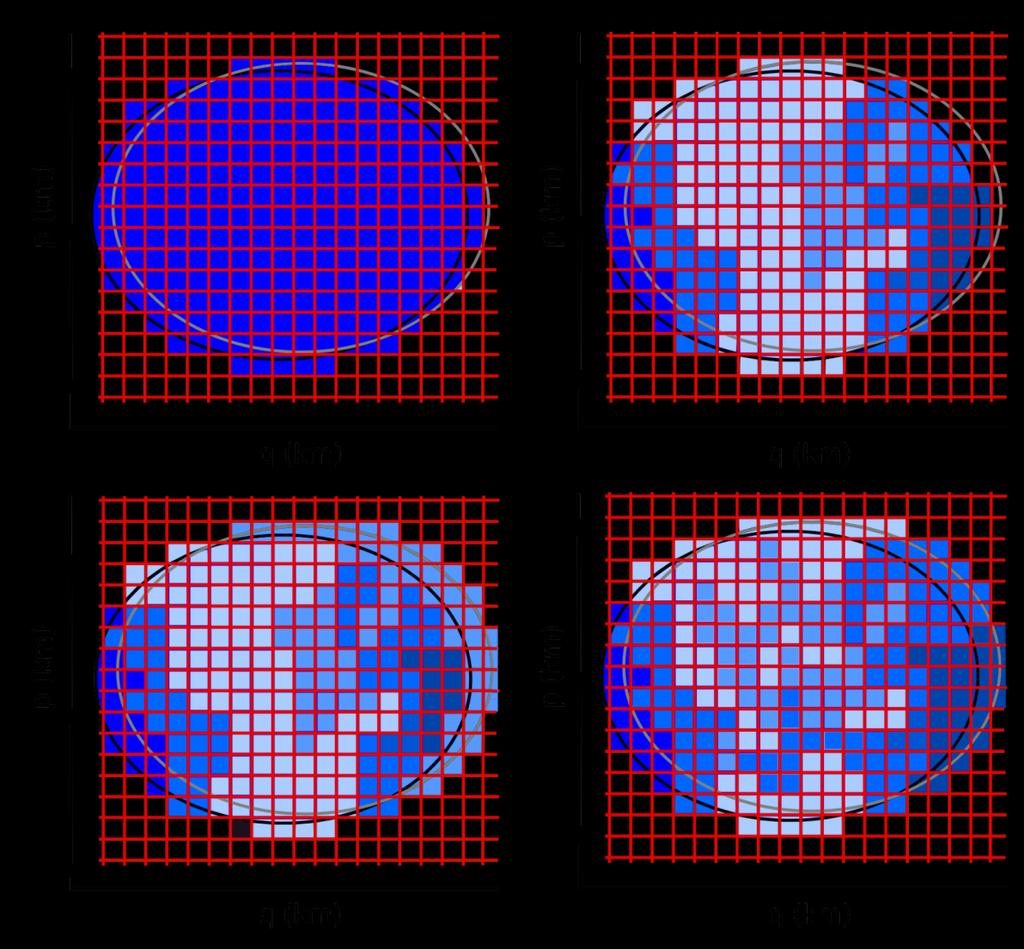
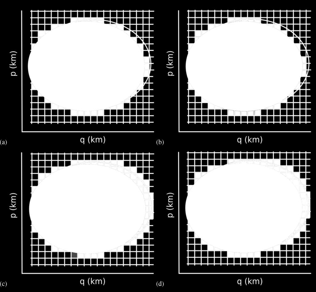
12 Going to Space Maximum Delay for 25 km resolution 12
13 GNSS-R from Space 25 km resolution requirement: 3 X 5 pixels used in L2 retrieval Downloaded to the ground: 17 x 11 pixels around specular point 13
14 GNSS-R from Space Typical space-borne GNSS-R Observable Decrease in sensitivity with wind speed N. Rodriguez-Alvarez and J. L. Garrison, TGARS DOI: /TGRS
15 CYGNSS Observables Ruf, et al, IEEE JSTARS 2018 DOI: /JSTARS
 Block IIR IIR-M (IIF Excluded) Ruf, et al, IEEE JSTARS 2018 DOI:10.")
16 CYGNSS Retrievals (U<20 m/s) Groundtruth: ECMWF 30.9 M matchups 1.96 m/s RMS (incl. error in ECMWF & interpolation) Block IIR IIR-M (IIF Excluded) Ruf, et al, IEEE JSTARS 2018 DOI: /JSTARS
17 CYGNSS Retrievals (U>20 m/s) Matchup: 674 pairs RMS = 6.45 m/s (ensemble statistics) Ruf, et al, IEEE JSTARS 2018 DOI: /JSTARS
18 Calibration very important: Transmitter EIRP Antennas CYGNSS Winds: Discussion Block II-F (variable power) currently excluded Sensitive to both winds and waves - model depends on fetch/wave age, consider: Coupled wind/wave retrievals [Clarizia and Ruf, JAOT 2017, DOI: /JTECH-D ] Roughness as the retrieval variable [Garrison, et al. GRSL 2011] Sensitivity decreases with winds (a lot for U > 20 m/s) 18
19 Outline Future Directions: Sequential Estimation Improved GMF Development Data Assimilation Non-GNSS Signals of Opportunity Conclusions 19
20 Sequential Estimation 20
21 Sequential Estimation Observation vector (y): DDM 1Hz (36x20) State vector (x k ) = 10 km gridded ocean mss (related to surface wind field using Katzberg model) Observation equation (h(x)): Discretized Zavorotny-Voronovich Integral 2 h( i, fd, tk, x) Bp( tk ) p p i, fd, tk ( i, fd, tk, x) j i i p Constant Properties Of Pixel p Ambiguity Function Averaged Over Pixel p Linearized Observation equation (Jacobian) (H(x)) Slope PDF At Pixel p 21


22 EKF Results: 2/12/
: Water vapor -> Refractivity -> bending angle Direct inversion")

23 Data Assimilation: The Way Forward Experience from GNSS Radio-occultation (GNSS-RO): Water vapor -> Refractivity -> bending angle Direct inversion (bending angle -> refractivity) assumes uniform properties over area covered by the integral Alternative: assimilate bending angle directly into weather models. 23

24 Data Assimilation: The Way Forward Reflectometry (GNSS-R): Winds -> MSS -> DDM Similar problem can we assimilate DDM s directly into forecast models? NASA Grant: NNX15AU18G Assimilation of GNSS-R Delay-Doppler Maps into Hurricane Models 24

25 Validation of Forward Model Tests on CYGNSS data from hurricane Irma on Sep. 4, 2017 case1 case2 33 rd AMS Hurricane Conference Ponte Vedra, FL, Apr 17,
26 Validation of Forward Model Tests on CYGNSS data from hurricane Irma on Sep. 4, 2017 Case1: near hurricane, U ~ 30 m/s. [33 rd AMS Hurricane Conference Ponte Vedra, FL, Apr 17, 2018] 26

27 Validation of Forward Model Tests on CYGNSS data from hurricane Irma on Sep. 4, 2017 Case2: medium wind speed, U ~ 20 m/s. [33 rd AMS Hurricane Conference Ponte Vedra, FL, Apr 17, 2018] 27
28 Validation of Forward Model Tests on CYGNSS data from hurricane Irma on Sep. 4, 2017 Case 3: low wind speed, U ~ 5 m/s. Can adjust noise floor in forward model for better match-up Currently testing with more accurate CYGNSS antenna patterns [33 rd AMS Hurricane Conference Ponte Vedra, FL, Apr 17, 2018] 28
29 Tests on CYGNSS data near Cyclone Enawo, Mar 6, 2017 Case4: very low wind speed, U < 2 m/s. Validation of Forward Model [33 rd AMS Hurricane Conference Ponte Vedra, FL, Apr 17, 2018] 29
30 Why GNSS? Continuous global coverage L-band good penetration of atmosphere, vegetation, rain, etc Pseudorandom noise (PRN) code designed for ranging My career began with GNSS!
31 What about other signals? Approximately 400 communication satellites in GEO High-powered (~30 db above GNSS) signals Allocations in most bands used for remote sensing: L,S, C, Ku/Ka Designed for data transmission Not ranging! Assumption: Compression & Encryption are very efficient at filling available spectrum Data is nearly random Direct signal can be used as reference

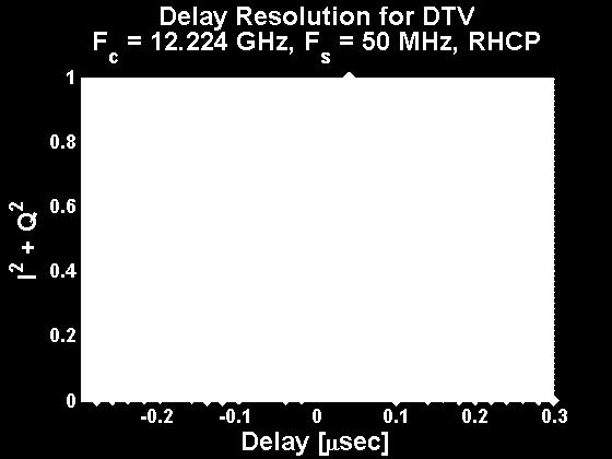
")
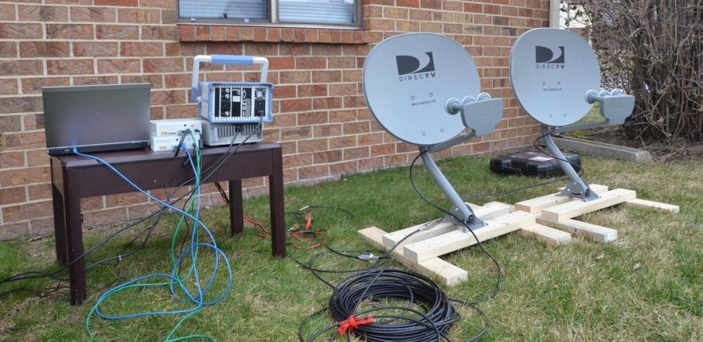
32 (Self-) Ambiguity Function (SAF) Measurement PSU PC DirecTV Antennas USRPs AMPs
")

33 2014 Hurricane season: 2-Jul-2014 to 17-Sep Hurricanes: Arthur, Bertha, Cristobal, Dolly, and Edouard S-band Satellite Digital Audio Radio Service (SDARS) signals Signals of Opportunity (SoOp) Winds Goals: Develop empirical PDF model for S-band (2.3 GHz) Assess high wind sensitivity of S-band reflectometry Processor RF front end, A/D Sampler 33

 MSS c (U 10 ) = 0.45(0.")
 Katzberg s model (L-band")

34 SoOp Hurricane Winds Wind Speed Retrieval Cox & Munk Model MSS u (U 10 ) = 0.45( U 10 ) MSS c (U 10 ) = 0.45( U 10 ) Katzberg s model (L-band empirical correction to C&M) U 10 = U 10true 0<U 10true <3.49 U 10 = 6 ln U 10true <U 10true <46 U 10 = U 10true 46<U 10true 34


35 SoOp Hurricane Winds [Zhang, et al., GRL in preparation] 35


36 SoOp Altimetry Sample coverage in 10 days from traditional altimetry orbit Ho, et al., PIERS 2017 Sample coverage in 3 days with 6 receivers in LEO observing transmitting constellation: DBS 9


37 Ku/K-BAND Antennas Experiment Description Beacon 27 m Receiver at JPL Shed Platform Harvest Ho, et al., PIERS
38 SoOp Altimetry (Ku-Band, LHCP) Theoretical Experimental SNR(dB) σ (cm) Theoretical Experimental SNR (db) σ (cm) Ho, et al., PIERS
39 SoOp Altimetry (Ku-Band, LHCP) σ = 5.63 cm Ho, et al., PIERS
40 Summary Spaceborne GNSS-R wind retrievals successfully demonstrated under some conditions. Sensitivity decreases for high winds (esp. U > 20 m/s) Calibration remains a big concern Perhaps wind speed is not the best variable: Wind/Wave coupling Fetch/Wave age dependence Direct DDM Assimilation GNSS-R just the beginning - many other signals are out there! Diversity of frequenices High EIRP (+30 db Vs. GNSS) 40
41 Acknowledgements NSPO generously provided for Prof. Garrison s travel expenses to attend ICGPSRO
THE CYGNSS NANOSATELLITE CONSTELLATION HURRICANE MISSION
 SSTDM2014, International Workshop on Small Satellites andsensor Technology for Disaster Management THE CYGNSS NANOSATELLITE CONSTELLATION HURRICANE MISSION Chris Ruf (1), Scott Gleason (2), Zorana Jelenak
The NASA EV-2 Cyclone Global Navigation Satellite System (CYGNSS) Mission
 Mission") International Ocean Vector Wind Science Team Meeting Kailua-Kona, Hawaii USA 6-8 May 2013 The NASA EV-2 Cyclone Global Navigation Satellite System (CYGNSS) Mission Chris Ruf (1) (CYGNSS Principal Investigator),
International Ocean Vector Wind Science Team Meeting Kailua-Kona, Hawaii USA 6-8 May 2013 The NASA EV-2 Cyclone Global Navigation Satellite System (CYGNSS) Mission Chris Ruf (1) (CYGNSS Principal Investigator),
Review of GNSS as sources of opportunity for Earth Observation
 NOAA UK-MetOffice Joofix Review of GNSS as sources of opportunity for Earth Observation Dr. Estel Cardellach (ICE-CSIC/IEEC, Spain) HISDESAT ESA Overview Motivation: contribution to a sustained and efficient
Geodetics measurements within the scope of current and future perspectives of GNSS-Reflectometry and GNSS-Radio Occultation
 Geodetics measurements within the scope of current and future perspectives of GNSS-Reflectometry and GNSS-Radio Occultation Introduction The aim of this presentation is to provide an overview of the GNSS-R
Preliminary evaluation of the impact of. cyclone assimilation and prediction
 Preliminary evaluation of the impact of the FORMOSAT 7R wind on tropical cyclone assimilation and prediction Shu Chih Yang 1,2, Cheng Chieh Kao 1,2, Wen Hao Yeh 3 and Stefani Huang 1 1 Dept. of Atmospheric
Application of Radio Occultation Data in Analyses and Forecasts of Tropical Cyclones Using an Ensemble Assimilation System
 Application of Radio Occultation Data in Analyses and Forecasts of Tropical Cyclones Using an Assimilation System Hui Liu, Jeff Anderson, and Bill Kuo NCAR Acknowledgment: C. Snyder, Y. Chen, T. Hoar,
Relationship between temporal and spatial resolution for a constellation of GNSS-R satellites
 JOURNAL OF SELECTED TOPICS IN APPLIED EARTH OBSERVATIONS AND REMOTE SENSING, CYGNSS SPECIAL ISSUE, DOI 10.1109/JSTARS.2018.2833426 1 Relationship between temporal and spatial resolution for a constellation
The NASA CYGNSS Mission; A Pathfinder for GNSS Scatterometry Remote Sensing Applications Randy Rose *11, Scott Gleason 1, Chris Ruf 2
 The NASA CYGNSS Mission; A Pathfinder for GNSS Scatterometry Remote Sensing Applications Randy Rose *11, Scott Gleason 1, Chris Ruf 2 1 Southwest Research Institute 2 University of Michigan ABSTRACT Global
Ocean Vector Winds in Storms from the SMAP L-Band Radiometer
 International Workshop on Measuring High Wind Speeds over the Ocean 15 17 November 2016 UK Met Office, Exeter Ocean Vector Winds in Storms from the SMAP L-Band Radiometer Thomas Meissner, Lucrezia Ricciardulli,
The NASA EV-2 Cyclone Global Navigation Satellite System (CYGNSS) Mission
 Mission") The NASA EV-2 Cyclone Global Navigation Satellite System (CYGNSS) Mission Chris Ruf University of Michigan AOSS Department Ann Arbor, MI 48109 734-764-6561 cruf@umich.edu Scott Gleason Concordia University
The NASA EV-2 Cyclone Global Navigation Satellite System (CYGNSS) Mission Chris Ruf University of Michigan AOSS Department Ann Arbor, MI 48109 734-764-6561 cruf@umich.edu Scott Gleason Concordia University
esa ACE+ An Atmosphere and Climate Explorer based on GPS, GALILEO, and LEO-LEO Occultation Per Høeg (AIR/DMI) Gottfried Kirchengast (IGAM/UG)
 Gottfried Kirchengast (IGAM/UG)") ACE+ An Atmosphere and Climate Explorer based on GPS, GALILEO, and LEO-LEO Occultation Per Høeg (AIR/DMI) Gottfried Kirchengast (IGAM/UG) OPAC-1, September, 2002 1 Objectives Climate Monitoring global
ACE+ An Atmosphere and Climate Explorer based on GPS, GALILEO, and LEO-LEO Occultation Per Høeg (AIR/DMI) Gottfried Kirchengast (IGAM/UG) OPAC-1, September, 2002 1 Objectives Climate Monitoring global
SMAP Winds. Hurricane Irma Sep 5, AMS 33rd Conference on Hurricanes and Tropical Meteorology Ponte Vedra, Florida, 4/16 4/20, 2018
 Intensity and Size of Strong Tropical Cyclones in 2017 from NASA's SMAP L-Band Radiometer Thomas Meissner, Lucrezia Ricciardulli, Frank Wentz, Remote Sensing Systems, Santa Rosa, USA Charles Sampson, Naval
Bringing Consistency into High Wind Measurements with Spaceborne Microwave Radiometers and Scatterometers
 International Ocean Vector Wind Science Team Meeting May 2-4, 2017, Scripps Bringing Consistency into High Wind Measurements with Spaceborne Microwave Radiometers and Scatterometers Thomas Meissner, Lucrezia
Future Opportunities of Using Microwave Data from Small Satellites for Monitoring and Predicting Severe Storms
 Future Opportunities of Using Microwave Data from Small Satellites for Monitoring and Predicting Severe Storms Fuzhong Weng Environmental Model and Data Optima Inc., Laurel, MD 21 st International TOV
IMPROVED MICROWAVE REMOTE SENSING OF HURRICANE WIND SPEED AND RAIN RATES USING THE HURRICANE IMAGING RADIOMETER (HIRAD)
") IMPROVED MICROWAVE REMOTE SENSING OF HURRICANE WIND SPEED AND RAIN RATES USING THE HURRICANE IMAGING RADIOMETER (HIRAD) Salem F. El-Nimri*, Suleiman Al-Sweiss, Ruba A Christopher S. Ruf Amarin, W. Linwood
IMPROVED MICROWAVE REMOTE SENSING OF HURRICANE WIND SPEED AND RAIN RATES USING THE HURRICANE IMAGING RADIOMETER (HIRAD) Salem F. El-Nimri*, Suleiman Al-Sweiss, Ruba A Christopher S. Ruf Amarin, W. Linwood
SIMULATING GNSS-R DELAY-DOPPLER MAP OF OIL SLICKED SEA SURFACES UNDER GENERAL SCENARIOS
 Progress In Electromagnetics Research B, Vol. 48, 61 76, 2013 SIMULATING GNSS-R DELAY-DOPPLER MAP OF OIL SLICKED SEA SURFACES UNDER GENERAL SCENARIOS Chen Li and Weimin Huang * Faculty of Engineering and
Observing System Simulation Experiments (OSSEs) with Radio Occultation observations
 with Radio Occultation observations") Observing System Simulation Experiments (OSSEs) with Radio Occultation observations Lidia Cucurull Deputy Director, NOAA Quantitative Observing System Assessment Program (QOSAP) NOAA OAR Principal Investigator
Observing System Simulation Experiments (OSSEs) with Radio Occultation observations Lidia Cucurull Deputy Director, NOAA Quantitative Observing System Assessment Program (QOSAP) NOAA OAR Principal Investigator
Summary of IROWG Activities
 Summary of IROWG Activities Co-Chairs: Ulrich Foelsche (University of Graz), Sean Healy (ECMWF) Rapporteur: Tony Mannucci (NASA/JPL) CGMS-45 COSMIC-IROWG, Korea, June Estes 2017 Park, Sept 2017 Slide:
IMPACT OF GROUND-BASED GPS PRECIPITABLE WATER VAPOR AND COSMIC GPS REFRACTIVITY PROFILE ON HURRICANE DEAN FORECAST. (a) (b) (c)
 (b) (c)") 9B.3 IMPACT OF GROUND-BASED GPS PRECIPITABLE WATER VAPOR AND COSMIC GPS REFRACTIVITY PROFILE ON HURRICANE DEAN FORECAST Tetsuya Iwabuchi *, J. J. Braun, and T. Van Hove UCAR, Boulder, Colorado 1. INTRODUCTION
9B.3 IMPACT OF GROUND-BASED GPS PRECIPITABLE WATER VAPOR AND COSMIC GPS REFRACTIVITY PROFILE ON HURRICANE DEAN FORECAST Tetsuya Iwabuchi *, J. J. Braun, and T. Van Hove UCAR, Boulder, Colorado 1. INTRODUCTION
We have processed RO data for climate research and for validation of weather data since 1995 as illustrated in Figure 1.
 Real-time Analysis of COSMIC Data Christian Rocken, Doug Hunt, Bill Schreiner University Corporation for Atmospheric Research (UCAR) COSMIC Project Office Boulder, CO Abstract UCAR has analyzed GPS radio
GNSS radio occultation measurements: Current status and future perspectives
 GNSS radio occultation measurements: Current status and future perspectives Sean Healy, Florian Harnisch Peter Bauer, Steve English, Jean-Nöel Thépaut, Paul Poli, Carla Cardinali, Outline GNSS radio occultation
Op#mized Tropical Cyclone Retrievals from ASCAT, OceanSAT- 2 and QuikSCAT
 Op#mized Tropical Cyclone Retrievals from ASCAT, OceanSAT- 2 and QuikSCAT Bryan W. S#les, Alex Fore, W. Lee Poulsen, Svetla- Hristova Veleva Jet Propulsion Laboratory, California Ins#tute of Technology
Status report on the current and future meteorological satellite systems by CMA
 Status report on the current and future meteorological satellite systems by CMA Presented to CGMS-44Plenary session, agenda item [D.1] Overview - Planning of China satellite systems by year 2025 NSIP:
ECMWF. ECMWF Land Surface Analysis: Current status and developments. P. de Rosnay M. Drusch, K. Scipal, D. Vasiljevic G. Balsamo, J.
 Land Surface Analysis: Current status and developments P. de Rosnay M. Drusch, K. Scipal, D. Vasiljevic G. Balsamo, J. Muñoz Sabater 2 nd Workshop on Remote Sensing and Modeling of Surface Properties,
Long term performance monitoring of ASCAT-A
 Long term performance monitoring of ASCAT-A Craig Anderson and Julia Figa-Saldaña EUMETSAT, Eumetsat Allee 1, 64295 Darmstadt, Germany. Abstract The Advanced Scatterometer (ASCAT) on the METOP series of
- an Operational Radio Occultation System
 - an Operational Radio Occultation System Frans Rubek, Georg Bergeton Larsen, Hans-Henrik Benzon, Kent Bækgaard Lauritsen, Martin Bjært Sørensen Danmarks Meteorologiske Institut (Denmark) Josep M. Aparicio,
Sensitivity of NWP model skill to the obliquity of the GPS radio occultation soundings
 ATMOSPHERIC SCIENCE LETTERS Atmos. Sci. Let. 13: 55 60 (2012) Published online 1 November 2011 in Wiley Online Library (wileyonlinelibrary.com) DOI: 10.1002/asl.363 Sensitivity of NWP model skill to the
The role of GPS-RO at ECMWF" ! COSMIC Data Users Workshop!! 30 September 2014! !!! ECMWF
 The role of GPS-RO at ECMWF"!!!! COSMIC Data Users Workshop!! 30 September 2014! ECMWF WE ARE Intergovernmental organisation! 34 Member and Cooperating European states! 270 staff at ECMWF, in Reading,
Operational Use of Scatterometer Winds at JMA
 Operational Use of Scatterometer Winds at JMA Masaya Takahashi Numerical Prediction Division, Japan Meteorological Agency (JMA) 10 th International Winds Workshop, Tokyo, 26 February 2010 JMA Outline JMA
P1.6 Simulation of the impact of new aircraft and satellite-based ocean surface wind measurements on H*Wind analyses
 P1.6 Simulation of the impact of new aircraft and satellite-based ocean surface wind measurements on H*Wind analyses Timothy L. Miller 1, R. Atlas 2, P. G. Black 3, J. L. Case 4, S. S. Chen 5, R. E. Hood
Vicky Chu, Jer Ling, Tom Lin, Joe Fong, Feng-Tai Huang, Guey-Shin Chang. April 15, 2011
 FORMOSAT-7/COSMIC-2 Overview Vicky Chu, Jer Ling, Tom Lin, Joe Fong, Feng-Tai Huang, Guey-Shin Chang April 15, 2011 Program Status AIT-TECRO Agreement on FORMOSAT-7/COSMIC-2 joint program has been signed
High Resolution Vector Wind Retrieval from SeaWinds Scatterometer Data
 High Resolution Vector Wind Retrieval from SeaWinds Scatterometer Data David G. Long Brigham Young University, 459 Clyde Building, Provo, UT 84602 long@ee.byu.edu http://www.scp.byu.edu Abstract The SeaWinds
Emerging Needs and Opportunities in Ocean Remote Sensing
 Emerging Needs and Opportunities in Ocean Remote Sensing Christine Gommenginger National Oceanography Centre, Southampton With thanks to: Chris Banks, Val Byfield, Paolo Cipollini, Nadim Dayoub, Giuseppe
Hyperspectral Microwave Atmospheric Sounding
 Hyperspectral Microwave Atmospheric Sounding W. J. Blackwell, L. J. Bickmeier, R. V. Leslie, M. L. Pieper, J. E. Samra, and C. Surussavadee 1 April 14, 2010 ITSC-17 This work is sponsored by the Department
STATUS ON THE USE OF SCATTEROMETER DATA AT METEO FRANCE
 STATUS ON THE USE OF SCATTEROMETER DATA AT METEO FRANCE Christophe Payan Centre National de Recherches Météorologiques, M CNRS-GAME CNRS and Météo-France Toulouse, France 9th International Winds Workshop,
URSI-F Microwave Signatures Meeting 2010, Florence, Italy, October 4 8, Thomas Meissner Lucrezia Ricciardulli Frank Wentz
 URSI-F Microwave Signatures Meeting 2010, Florence, Italy, October 4 8, 2010 Wind Measurements from Active and Passive Microwave Sensors High Winds and Winds in Rain Thomas Meissner Lucrezia Ricciardulli
Meeting the Needs for Satellite OVW
 Meeting the Needs for Satellite OVW NEED Multiple scatterometers to extend the coverage of QuikSCAT and provide continuity UNDERWAY EUMETSAT ASCAT on METOP series 1 st is in orbit ISRO Oceansat-2 Timely
Determining Real Permittivity from Fresnel Coefficients in GNSS-R
 Progress In Electromagnetics Research M, Vol. 79, 159 166, 019 Determining Real Permittivity from Fresnel Coefficients in GNSS-R Patrizia Savi 1, *, Silvano Bertoldo 1, and Albert Milani, 3 Abstract Global
Progress on the assimilation of GNSS-RO at ECMWF
 Progress on the assimilation of GNSS-RO at ECMWF Sean Healy ECMWF/ROM SAF Many thanks to Chris Burrows, Ian Culverwell, Chris Marquardt, Sergey Sokolovskiy, the ROM SAF, Adrian Simmons, ECMWF November
Stability in SeaWinds Quality Control
 Ocean and Sea Ice SAF Technical Note Stability in SeaWinds Quality Control Anton Verhoef, Marcos Portabella and Ad Stoffelen Version 1.0 April 2008 DOCUMENTATION CHANGE RECORD Reference: Issue / Revision:
Interacciones en la Red Iberica
 2a Reunion Red Iberica MM5 Grupo 12: interacciones, modelo mm5 y proyectos actuales Lidia Cucurull UCAR - NOAA/NCEP Washington DC, USA http://www.cosmic.ucar.edu Lidia.Cucurull@noaa.gov cucurull@ucar.edu
Dual-Frequency Ku- Band Radar Mission Concept for Snow Mass
 Dual-Frequency Ku- Band Radar Mission Concept for Snow Mass Chris Derksen Environment and Climate Change Canada Study Team: Climate Research Division/Meteorological Research Division, ECCC Canadian Space
P. Cipollini, H. Snaith - A short course on Altimetry. Altimetry 2 - Data processing (from satellite height to sea surface height)
") P. Cipollini, H. Snaith - A short course on Altimetry Altimetry 2 - Data processing (from satellite height to sea surface height) 1 2 Satellite height to sea surface height The altimeter measures the altitude
P. Cipollini, H. Snaith - A short course on Altimetry Altimetry 2 - Data processing (from satellite height to sea surface height) 1 2 Satellite height to sea surface height The altimeter measures the altitude
Aquarius Data Release V2.0 Validation Analysis Gary Lagerloef, Aquarius Principal Investigator H. Kao, ESR And Aquarius Cal/Val Team
 Aquarius Data Release V2.0 Validation Analysis Gary Lagerloef, Aquarius Principal Investigator H. Kao, ESR And Aquarius Cal/Val Team Analysis period: Sep 2011-Dec 2012 SMOS-Aquarius Workshop 15-17 April
Assimilation Experiments of One-dimensional Variational Analyses with GPS/MET Refractivity
 Assimilation Experiments of One-dimensional Variational Analyses with GPS/MET Refractivity Paul Poli 1,3 and Joanna Joiner 2 1 Joint Center for Earth Systems Technology (JCET), University of Maryland Baltimore
WindSat Ocean Surface Emissivity Dependence on Wind Speed in Tropical Cyclones. Amanda Mims University of Michigan, Ann Arbor, MI
 WindSat Ocean Surface Emissivity Dependence on Wind Speed in Tropical Cyclones Amanda Mims University of Michigan, Ann Arbor, MI Abstract Radiometers are adept at retrieving near surface ocean wind vectors.
GNSS reflectometry aboard the International Space Station GEROS-ISS: Numerical simulation of expected observation coverage
 GNSS reflectometry aboard the International Space Station GEROS-ISS: Numerical simulation of expected observation coverage V. Leister 1,2, M. Semmling 2, J. Wickert 2, G. Beyerle 2, H. Schuh 1,2 1. Technische
VELOX-CI: Advanced Application of GPS for Radio Occultation and Satellite Attitude Determination
 VELOX-CI: Advanced Application of GPS for Radio Occultation and Satellite Attitude Determination Yung-Fu Tsai, Guo Xiong Lee and Kay Soon Low Satellite Research Centre (SaRC) School of Electrical and Electronic
Climate Monitoring with GPS RO Achievements and Challenges
 Climate Monitoring with GPS RO Achievements and Challenges A.K. Steiner Wegener Center for Climate and Global Change (WEGC) and IGAM/Inst. of Physics, University of Graz, Austria andi.steiner@uni-graz.at
Use of ground-based GNSS measurements in data assimilation. Reima Eresmaa Finnish Meteorological Institute
 Use of ground-based GNSS measurements in data assimilation Reima Eresmaa Finnish Meteorological Institute 16 June 2006 Outline 1) Introduction GNSS * positioning Tropospheric delay 2) GNSS as a meteorological
Current and Upcoming NASA Hurricane Measurement Missions National Hurricane Conference
 NASA Science Mission Directorate Earth Science Division Applied Sciences Program Current and Upcoming NASA Hurricane Measurement Missions National Hurricane Conference April 18, 2017 Formulation Implementation
Use of FY-3C/GNOS Data for Assessing the on-orbit Performance of Microwave Sounding Instruments
 Use of FY-3C/GNOS Data for Assessing the on-orbit Performance of Microwave Sounding Instruments Xiuqing Hu 1 Xueyan Hou 2, and Mi Liao 1 1 National Satellite Meteorological Center (NSMC), CMA 2 Chinese
ROCSAT-3 Constellation Mission
 ROCSAT-3 Constellation Mission, An-Ming Wu, Paul Chen National Space Program Office 8F, 9 Prosperity 1st Road, Science Based Industrial Park, Hsin-Chu, Taiwan vicky@nspo.org.tw, amwu@nspo.org.tw, paulchen@nspo.org.tw
WIND PROFILER NETWORK OF JAPAN METEOROLOGICAL AGENCY
 WIND PROFILER NETWORK OF JAPAN METEOROLOGICAL AGENCY Masahito Ishihara Japan Meteorological Agency CIMO Expert Team on Remote Sensing Upper-Air Technology and Techniques 14-17 March, 2005 Geneva, Switzerland
Long-Term Time Series of Water Vapour Total Columns from GOME, SCIAMACHY and GOME-2
 Graphics: ESA Graphics: ESA Graphics: ESA Long-Term Time Series of Water Vapour Total Columns from GOME, SCIAMACHY and GOME-2 S. Noël, S. Mieruch, H. Bovensmann, J. P. Burrows Institute of Environmental
Calibrating SeaWinds and QuikSCAT scatterometers using natural land targets
 Brigham Young University BYU ScholarsArchive All Faculty Publications 2005-04-01 Calibrating SeaWinds and QuikSCAT scatterometers using natural land targets David G. Long david_long@byu.edu Lucas B. Kunz
Numerical Weather Prediction in 2040
 Numerical Weather Prediction in 2040 10.8 µm GEO imagery (simulated!) Peter Bauer, ECMWF Acks.: N. Bormann, C. Cardinali, A. Geer, C. Kuehnlein, C. Lupu, T. McNally, S. English, N. Wedi will not discuss
Development of the Next Generation GRAS Instrument
 Development of the Next Generation GRAS Instrument Jacob Christensen Magnus Bonnedal, Anders Carlström, Thomas Lindgren Sean Healy (ECMWF), Hans-Henrik Benzon (DMI) RUAG Space Gothenburg Sweden D-I-HO-00022-RSE,
OCEAN VECTOR WINDS IN STORMS FROM THE SMAP L-BAND RADIOMETER
 Proceedings for the 2016 EUMETSAT Meteorological Satellite Conference, 26-30 September 2016, Darmstadt, Germany OCEAN VECTOR WINDS IN STORMS FROM THE SMAP L-BAND RADIOMETER Thomas Meissner, Lucrezia Ricciardulli,
The satellite winds in the operational NWP system at Météo-France
 The satellite winds in the operational NWP system at Météo-France Christophe Payan CNRM UMR 3589, Météo-France/CNRS 13th International Winds Workshop, Monterey, USA, 27 June 1st July 2016 Outline Operational
The NASA EV-2 Cyclone Global Navigation Satellite System (CYGNSS) Mission
 Mission") The NASA EV2 Cyclone Global Navigation Satellite System (CYGNSS) Mission Chris Ruf University of Michigan AOSS Department Ann Arbor, MI 48109 7347646561 cruf@umich.edu Scott Gleason Concordia University
The NASA EV2 Cyclone Global Navigation Satellite System (CYGNSS) Mission Chris Ruf University of Michigan AOSS Department Ann Arbor, MI 48109 7347646561 cruf@umich.edu Scott Gleason Concordia University
7.4 GPS-Based Measurements of Ocean Surface Roughness. Stephen J. Katzberg NASA Langley Research Center Hampton, VA 23681
 7.4 GPS-Based Measurements of Ocean Surface Roughness Stephen J. Katzberg NASA Langley Research Center Hampton, VA 3681 1. INTRODUCTION: Recent results have shown that the GPS reflection technique can
N E S D I S C D A A C. COSMIC Operations JCSDA TACC NCEP ECMWF CWB GTS UKMO
 CDAAC Activities Bill Schreiner B. Kuo, C. Rocken, S. Sokolovskiy, D. Hunt, X. Yue, J. Zeng, K. Hudnut, M. Sleziak, T.-K. Wee, T. Vanhove, J. Lin UCAR / COSMIC Program Office - Boulder CO COSMIC IWG Meeting
IMPORTANCE OF SATELLITE DATA (FOR REANALYSIS AND BEYOND) Jörg Schulz EUMETSAT
 Jörg Schulz EUMETSAT") IMPORTANCE OF SATELLITE DATA (FOR REANALYSIS AND BEYOND) Jörg Schulz EUMETSAT Why satellite data for climate monitoring? Global coverage Global consistency, sometimes also temporal consistency High spatial
IMPORTANCE OF SATELLITE DATA (FOR REANALYSIS AND BEYOND) Jörg Schulz EUMETSAT Why satellite data for climate monitoring? Global coverage Global consistency, sometimes also temporal consistency High spatial
Q-Winds Hurricane Retrieval Algorithm using QuikSCAT Scatterometer
 Q-Winds Hurricane Retrieval Algorithm using QuikSCAT Scatterometer Pete Laupattarakasem Doctoral Dissertation Defense March 23 rd, 2009 Presentation Outline Dissertation Objective Background Scatterometry/Radiometry
Assessing the impact of assimilating CYGNSS ocean surface winds on tropical cyclone analyses and forecasts with regional OSSEs
 7A.6 Assessing the impact of assimilating CYGNSS ocean surface winds on tropical cyclone analyses and forecasts with regional OSSEs Shixuan Zhang * and Zhaoxia Pu Department of Atmospheric Sciences, University
AWDP km. 25 km
 MyOcean2 Wind AWDP 1 12.5 km 25 km Tropical variability 1. Dry areas reasonable 2. NWP models lack airsea interaction in rainy areas 3. ASCAT scatterometer does a good job near rain 4. QuikScat, OSCAT
Scatterometer Wind Assimilation at the Met Office
 Scatterometer Wind Assimilation at the Met Office James Cotton International Ocean Vector Winds Science Team (IOVWST) meeting, Brest, June 2014 Outline Assimilation status Global updates: Metop-B and spatial
The impact of assimilation of microwave radiance in HWRF on the forecast over the western Pacific Ocean
 The impact of assimilation of microwave radiance in HWRF on the forecast over the western Pacific Ocean Chun-Chieh Chao, 1 Chien-Ben Chou 2 and Huei-Ping Huang 3 1Meteorological Informatics Business Division,
WMO Space Programme: anticipated evolution and a Picture of Development of a Vision of WIGOS Space-based Component in 2040
 WMO Space Programme: anticipated evolution and a Picture of 2040 --Development of a Vision of WIGOS Space-based Component in 2040 Wenjian Zhang Director, Observing and Information Systems Department &
ASSIMILATION OF GRAS GPS RADIO OCCULTATION MEASUREMENTS AT ECMWF
 ASSIMILATION OF GRAS GPS RADIO OCCULTATION MEASUREMENTS AT ECMWF Sean Healy ECMWF, Shinfield Park, Reading, UK. Abstract GPS radio occultation bending angle profiles are assimilated from the GRAS instrument
Next generation of EUMETSAT microwave imagers and sounders: new opportunities for cloud and precipitation retrieval
 Next generation of EUMETSAT microwave imagers and sounders: new opportunities for cloud and precipitation retrieval Christophe Accadia, Sabatino Di Michele, Vinia Mattioli, Jörg Ackermann, Sreerekha Thonipparambil,
ASCAT B OCEAN CALIBRATION AND WIND PRODUCT RESULTS
 ASCAT B OCEAN CALIBRATION AND WIND PRODUCT RESULTS Jeroen Verspeek 1, Ad Stoffelen 1, Anton Verhoef 1, Marcos Portabella 2, Jur Vogelzang 1 1 KNMI, Royal Netherlands Meteorological Institute, De Bilt,
Precise Orbit Determination and Radio Occultation Retrieval Processing at the UCAR CDAAC: Overview and Results
 Precise Orbit Determination and Radio Occultation Retrieval Processing at the UCAR CDAAC: Overview and Results Bill Schreiner B. Kuo, C. Rocken, S. Sokolovskiy, D. Hunt, X. Yue, K. Hudnut, M. Sleziak,
Operational Use of Scatterometer Winds in the JMA Data Assimilation System
 Operational Use of Scatterometer Winds in the Data Assimilation System Masaya Takahashi Numerical Prediction Division, Japan Meteorological Agency () International Ocean Vector Winds Science Team Meeting,
EXPERIMENTAL ASSIMILATION OF SPACE-BORNE CLOUD RADAR AND LIDAR OBSERVATIONS AT ECMWF
 EXPERIMENTAL ASSIMILATION OF SPACE-BORNE CLOUD RADAR AND LIDAR OBSERVATIONS AT ECMWF Marta Janisková, Sabatino Di Michele, Edouard Martins ECMWF, Shinfield Park, Reading, U.K. Abstract Space-borne active
Remote Sensing I: Basics
 Remote Sensing I: Basics Kelly M. Brunt Earth System Science Interdisciplinary Center, University of Maryland Cryospheric Science Laboratory, Goddard Space Flight Center kelly.m.brunt@nasa.gov (Based on
3D.6 ESTIMATES OF HURRICANE WIND SPEED MEASUREMENT ACCURACY USING THE AIRBORNE HURRICANE IMAGING RADIOMETER
 3D.6 ESTIMATES OF HURRICANE WIND SPEED MEASUREMENT ACCURACY USING THE AIRBORNE HURRICANE IMAGING RADIOMETER Ruba A. Amarin *, Linwood Jones 1, James Johnson 1, Christopher Ruf 2, Timothy Miller 3 and Shuyi
The Use of GPS Radio Occultation Data for Tropical Cyclone Prediction. Bill Kuo and Hui Liu UCAR
 The Use of GPS Radio Occultation Data for Tropical Cyclone Prediction Bill Kuo and Hui Liu UCAR Current capability of the National Hurricane Center Good track forecast improvements. Errors cut in half
Tsunami Detection from Space using GNSS Reflections
 Tsunami Detection from Space using GNSS Reflections R. Stosius, G. Beyerle, A. Helm, A. Hoechner, and J. Wickert Nat. Hazards Earth Syst. Sci., 10, 1359 1372, 2010 1 Tsunami Detection from Space Global
On the impact of the assimilation of ASAR wave spectra in the wave model MFWAM
 On the impact of the assimilation of ASAR wave spectra in the wave model MFWAM Lotfi Aouf, Jean-Michel Lefèvre Météo-France, Toulouse SEASAR 2012, 4 th International workshop on Advances in SAR oceanography,
Severe Weather Simulation Experiment (QuickOSSE) Using Super Constellations of GNSS Radio Occultation Satellites
 Using Super Constellations of GNSS Radio Occultation Satellites") Severe Weather Simulation Experiment (QuickOSSE) Using Super Constellations of GNSS Radio Occultation Satellites S. Mark Leidner 1, Thomas Nehrkorn 1, John Henderson 1, Marikate Mountain 1, Tom Yunck 2
Severe Weather Simulation Experiment (QuickOSSE) Using Super Constellations of GNSS Radio Occultation Satellites S. Mark Leidner 1, Thomas Nehrkorn 1, John Henderson 1, Marikate Mountain 1, Tom Yunck 2
THE ROLE OF MICROSTRUCTURE IN FORWARD MODELING AND DATA ASSIMILATION SCHEMES: A CASE STUDY IN THE KERN RIVER, SIERRA NEVADA, USA
 MICHAEL DURAND (DURAND.8@OSU.EDU), DONGYUE LI, STEVE MARGULIS Photo: Danielle Perrot THE ROLE OF MICROSTRUCTURE IN FORWARD MODELING AND DATA ASSIMILATION SCHEMES: A CASE STUDY IN THE KERN RIVER, SIERRA
The Impacts of GPS Radio Occultation Data on the Analysis and Prediction of Tropical Cyclones. Bill Kuo, Xingqin Fang, and Hui Liu UCAR COSMIC
 The Impacts of GPS Radio Occultation Data on the Analysis and Prediction of Tropical Cyclones Bill Kuo, Xingqin Fang, and Hui Liu UCAR COSMIC GPS Radio Occultation α GPS RO observations advantages for
Introduction to TIGGE and GIFS. Richard Swinbank, with thanks to members of GIFS-TIGGE WG & THORPEX IPO
 Introduction to TIGGE and GIFS Richard Swinbank, with thanks to members of GIFS-TIGGE WG & THORPEX IPO GIFS-TIGGE/NCAR/NOAA Workshop on EPS developments, June 2012 TIGGE THORPEX Interactive Grand Global
Recent improvements on the wave forecasting system of Meteo-France: modeling and assimilation aspects
 Recent improvements on the wave forecasting system of Meteo-France: modeling and assimilation aspects L. Aouf and J-M. Lefèvre Division Marine et Océanographie, Météo-France 13 th International workshop
Q-Winds satellite hurricane wind retrievals and H*Wind comparisons
 Q-Winds satellite hurricane wind retrievals and H*Wind comparisons Pet Laupattarakasem and W. Linwood Jones Central Florida Remote Sensing Laboratory University of Central Florida Orlando, Florida 3816-
Variability of the Boundary Layer Depth over Certain Regions of the Subtropical Ocean from 3 Years of COSMIC Data
 Variability of the Boundary Layer Depth over Certain Regions of the Subtropical Ocean from 3 Years of COSMIC Data S. Sokolovskiy, D. Lenschow, C. Rocken, W. Schreiner, D. Hunt, Y.-H. Kuo and R. Anthes
The impact of the assimilation of altimeters and ASAR L2 wave data in the wave model MFWAM
 The impact of the assimilation of altimeters and ASAR L2 wave data in the wave model MFWAM Lotfi Aouf 1, Jean-Michel Lefèvre 1 1) Météo-France, Toulouse 12 th Wave Hindcasting and Forecasting, Big Island
IN ORBIT VERIFICATION RESULTS FROM GRAS RECEIVER ON METOP-A SATELLITE
 IN ORBIT VERIFICATION RESULTS FROM GRAS RECEIVER ON METOP-A SATELLITE Marc Loiselet (1), Nico Stricker (1), Jacob Christensen (2), Carmelo Carrascosa (3) (1) ESA/ESTEC, Keplerlaan 1, 22 AG Noordwijk, The
The Green-OAWL (GrOAWL) Airborne Demonstrator for the ATHENA-OAWL Mission Concept: System Progress and Flight Plans
 Airborne Demonstrator for the ATHENA-OAWL Mission Concept: System Progress and Flight Plans") The Green-OAWL (GrOAWL) Airborne Demonstrator for the ATHENA-OAWL Mission Concept: System Progress and Flight Plans International Winds Working Group Workshop 27 June 1 July 2016 Monterey, CA Sara Tucker
The Green-OAWL (GrOAWL) Airborne Demonstrator for the ATHENA-OAWL Mission Concept: System Progress and Flight Plans International Winds Working Group Workshop 27 June 1 July 2016 Monterey, CA Sara Tucker
Orbit and Transmit Characteristics of the CloudSat Cloud Profiling Radar (CPR) JPL Document No. D-29695
 JPL Document No. D-29695") Orbit and Transmit Characteristics of the CloudSat Cloud Profiling Radar (CPR) JPL Document No. D-29695 Jet Propulsion Laboratory California Institute of Technology Pasadena, CA 91109 26 July 2004 Revised
Orbit and Transmit Characteristics of the CloudSat Cloud Profiling Radar (CPR) JPL Document No. D-29695 Jet Propulsion Laboratory California Institute of Technology Pasadena, CA 91109 26 July 2004 Revised
ARUBA CLIMATOLOGICAL SUMMARY 2014 PRECIPITATION
 ARUBA CLIMATOLOGICAL SUMMARY 2014 PRECIPITATION The total amount of rainfall recorded at Reina Beatrix International Airport for the year 2014 was 309.2 mm. This is 34.4 % below normal ( Figure 1 ). During
The Properties of Convective Clouds over the Western Pacific and Their Relationship to the Environment of Tropical Cyclones
 DISTRIBUTION STATEMENT A. Approved for public release; distribution is unlimited. The Properties of Convective Clouds over the Western Pacific and Their Relationship to the Environment of Tropical Cyclones
onboard of Metop-A COSMIC Workshop 2009 Boulder, USA
 GRAS Radio Occultation Measurements onboard of Metop-A A. von Engeln 1, Y. Andres 1, C. Cardinali 2, S. Healy 2,3, K. Lauritsen 3, C. Marquardt 1, F. Sancho 1, S. Syndergaard 3 1 2 3 EUMETSAT, ECMWF, GRAS
Retrieval Algorithm Using Super channels
 Retrieval Algorithm Using Super channels Xu Liu NASA Langley Research Center, Hampton VA 23662 D. K. Zhou, A. M. Larar (NASA LaRC) W. L. Smith (HU and UW) P. Schluessel (EUMETSAT) Hank Revercomb (UW) Jonathan
Comparison of Travel-time statistics of Backscattered Pulses from Gaussian and Non-Gaussian Rough Surfaces
 Comparison of Travel-time statistics of Backscattered Pulses from Gaussian and Non-Gaussian Rough Surfaces GAO Wei, SHE Huqing Yichang Testing Technology Research Institute No. 55 Box, Yichang, Hubei Province
GRAS SAF Workshop on Applications of GPS Radio Occultation Measurements. ECMWF Reading, UK; June 2008
 GRAS SAF Workshop on Applications of GPS Radio Occultation Measurements ECMWF Reading, UK; 16-18 June 08 Climate Signal Detection with GPS Radio Occultation Measurements (focus trend signal detection,
Feiqin Xie. Curriculum Vitae (Feiqin Xie)
") Feiqin Xie Assistant Professor in Atmospheric Sciences Department of Physical & Environmental Sciences Texas A&M University-Corpus Christi 6300 Ocean Drive, Unit 5850 Corpus Christi, Texas 78412-5850 Email:
Feiqin Xie Assistant Professor in Atmospheric Sciences Department of Physical & Environmental Sciences Texas A&M University-Corpus Christi 6300 Ocean Drive, Unit 5850 Corpus Christi, Texas 78412-5850 Email:
NOAA Satellite & Information Service (NESDIS)
") Transition from Research to Operation for GNSS Radio Occultation Abigail D. Harper National Environmental Satellite, Data, and Information Service (NESDIS) Deputy Assistant Administrator, Systems April
Transition from Research to Operation for GNSS Radio Occultation Abigail D. Harper National Environmental Satellite, Data, and Information Service (NESDIS) Deputy Assistant Administrator, Systems April