Characterizing the Structure of Hurricane Karl (2010): Doppler Radar and WRF
|
|
|
- Katherine Chase
- 5 years ago
- Views:
Transcription

1 Characterizing the Structure of Hurricane Karl (2010): Doppler Radar and WRF Jennifer DeHart and Robert Houze Atmospheric Physics and Chemistry Seminar NASA grants: NNX13AG71G / NNX12AJ82G
2 Orographic Modification of Clouds Subject of numerous studies Peter Hobbs, Ron Smith, Dale, Bob Cascade Project, DOMEX, IMPROVE, OLYMPEX Dynamics, precipitation processes, etc Tropical cyclones less of a focus
3 Orographic Modification of TCs Most research focuses on track deviations and intensity changes Chang 1982, Bender et al. 1987, Roux et al. 2004, etc. TCs under examination generally interact with an island (e.g., Taiwan) Exceptions: Bender et al and Zehnder 1993(a)
4 How does orographic modification occur? Type of cloud processes that occur Characteristics Intensity, duration, location Enhancement vs. redistribution
5 Orographic Enhancement Process Tied to underlying thermodynamic and kinematic characteristics Two sample mechanisms Convection triggered by terrain Seeder-feeder process Image: Houze (2012)


6 Cloud Water Yu and Cheng 2008 Smith et al Warm-rain process orographically generated cloud water Diagnosed from horizontal reflectivity / thermodynamic profiles

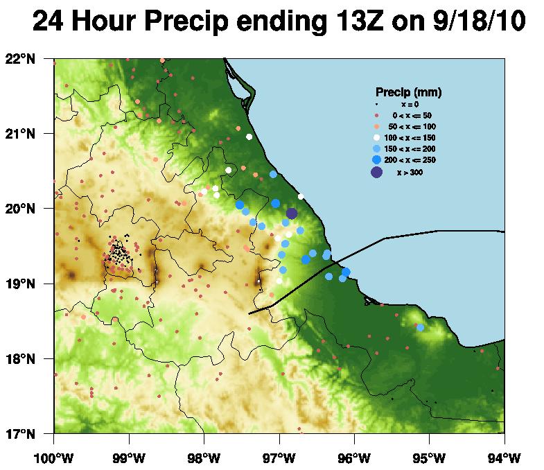
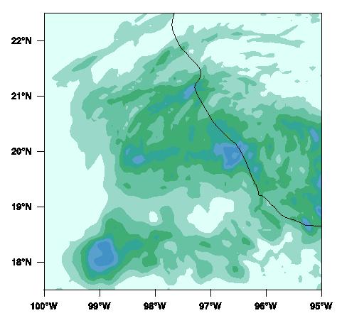
7 Not so fast! Geerts et al Vertical radar measurements showed development of convection where the eye used to reside release of potential instability within eye?

8 Where does the precipitation fall? Background wind speed and orography geometry both determine location of maximum precipitation

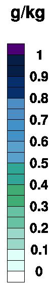
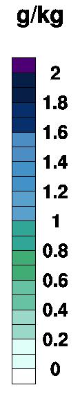
9 Precipitation Metrics Misumi mm 141 mm Precipitation = intensity time Precipitation does not have to be intense to cause devastating accumulation
10 What does Karl bring? Mexico is not an island large horizontal extent, slightly higher peak elevations (> 3 km) Airborne radar data provides glimpse at vertical dimension
11 Science Questions What do airborne radar measurements indicate about the nature of the precipitation during landfall over the mountainous terrain of Mexico? What can WRF simulations tell us about the underlying processes?

12 Hurricane Karl (2010)

13 Karl Best Track and Flights Flight Image: NHC


14 Rainfall and Mexican Terrain Intense rainfall collocated with eastern edge of Mexican terrain Maximum rainfall measured near Misantla Image: David Roth, NOAA
15
16 NASA GRIP DC 8 Flight Track 09/17/2010 Aug. / Sept Key instrument: APR-2 radar on DC8-10 km flight level -Ku / Ka band -high resolution -downward pointing -cross-track scan
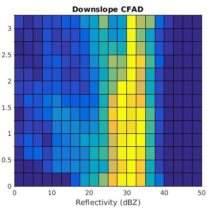
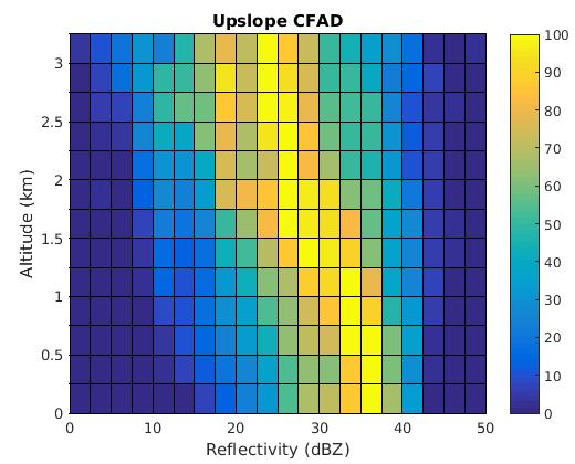
17 Upstream Sounding


18 Karl Circulation at 19Z

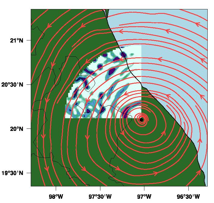
19 Upslope Segment Minutes after 1800 Z Low-level enhancement present in reflectivity data Warm-rain process
20 Orizaba ~210 mm? Jalapa flight ~212 mm? data from NCDC/NHC

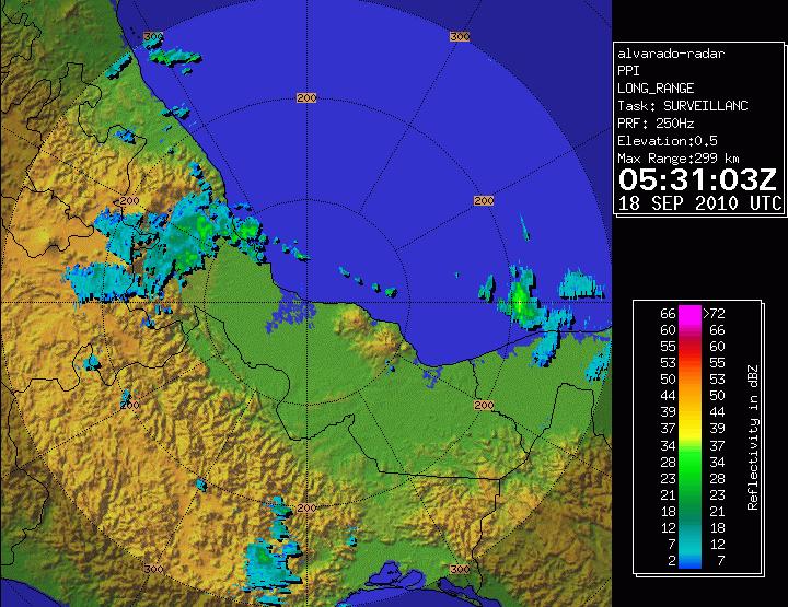
21 3-Hour Precip Locations

22 Downslope Segment Minutes after 1900 Z Low-level enhancement not present Fall streaks from melting ice aggregates
23 data c/o Michel Rosengaus Cordoba

24 Upslope and Downslope Segments Compare reflectivity profiles for upslope and downslope flight legs Removed surface and beams likely to have suffered attenuation
25 Height Above Terrain (km) Reflectivity (dbz) Mean profile shows strong enhancement in upslope segments, downslope segments remain fairly constant towards surface
26 Distributions consistent with the mean profile
27 Cordoba
28 0530Z Convection
29
30 Terrain Modification Experiments
31 WRF Details WRF Initialized at 00Z on 9/15/ domains: 54, 18, 6, 2 km 2, 6 km domains follow vortex Microphysics: Goddard Boundary Layer: MYJ Levels: 70 Two runs: control and reduced terrain


32 Observed and Simulated Tracks Control run: traces observed track (storm motion too fast). Flat terrain run: track shifts northward.
33 Modeled Intensity Best Track Control Modified Terrain Karl s intensity is underestimated, but general trend is captured Modified terrain run reaches deeper intensity and does not drop off as quickly

34 Accumulated Precipitation


35 Cloud Water Rain


36 Flat Terrain Cloud Water Rain Full Terrain


37 Full Terrain Flat Terrain
38 CONCLUSIONS Upslope flow produces enhanced nearsurface reflectivity in Karl cloud water collected by drops or shallow convection Downslope flow does not have the low-level signature Mixture of gentle ascent + deeper convection WRF simulations consistent enhanced cloud water / rain trace terrain vertical distributions shift towards greater hydrometeor mixing ratios

39 A larger view... Background precipitation important to determining enhancement Landfall complicates matters by removing energy source
Rogers and Yau Chapter 12: Precipitation Processes (emphasizing stratiform rain convection and severe storms will be next lecture)
") Rogers and Yau Chapter 12: Precipitation Processes (emphasizing stratiform rain convection and severe storms will be next lecture) There is a relationship between the scale of atmospheric vertical motions
Rogers and Yau Chapter 12: Precipitation Processes (emphasizing stratiform rain convection and severe storms will be next lecture) There is a relationship between the scale of atmospheric vertical motions
Observational analysis of storms and flooding events in the Pacific Northwest. Introduction
 Observational analysis of storms and flooding events in the Pacific Northwest Jake Crouch UNCA ATMS Class of 2007 April 18, 2009 Cloud and Precipitation Processes and Patterns Group Introduction Average
Severe storms over the Mediterranean Sea: A satellite and model analysis
 National Research Council of Italy Severe storms over the Mediterranean Sea: A satellite and model analysis V. Levizzani, S. Laviola, A. Malvaldi, M. M. Miglietta, and E. Cattani 6 th International Precipitation
Objectives for meeting
 Objectives for meeting 1) Summarize planned experiments 2) Discuss resource availability Aircraft Instrumentation Expendables 3) Assign working groups to complete each experiment plan Flight planning and
Synoptic and Orographic Control of Observed Drop Size Distribution Regimes in Atmospheric River events during the OLYMPEX Field Campaign
 Synoptic and Orographic Control of Observed Drop Size Distribution Regimes in Atmospheric River events during the OLYMPEX Field Campaign Joe Zagrodnik Lynn McMurdie, Robert A. Houze University of Washington
L. McMurdie, R. Houze, J. Zagrodnik, W. Petersen, M. Schwaller
 L. McMurdie, R. Houze, J. Zagrodnik, W. Petersen, M. Schwaller International Atmospheric Rivers Conference, San Diego, CA, 9 August 2016 Goals of OLYMPEX Validate GPM satellite radar and passive microwave
TWO CASES OF HEAVY RAIN ON THE MEDITERRANEAN SIDE OF THE ALPS IN MAP. Robert Houze 1 and Socorro Medina University of Washington
 1.1 TWO CASES OF HEAVY RAIN ON THE MEDITERRANEAN SIDE OF THE ALPS IN MAP Robert Houze 1 and Socorro Medina University of Washington Matthias Steiner Princeton University 1. INTRODUCTION The Mesoscale Alpine
Precipitation Structure and Processes of Typhoon Nari (2001): A Modeling Propsective
: A Modeling Propsective") Precipitation Structure and Processes of Typhoon Nari (2001): A Modeling Propsective Ming-Jen Yang Institute of Hydrological Sciences, National Central University 1. Introduction Typhoon Nari (2001) struck
Precipitation Structure and Processes of Typhoon Nari (2001): A Modeling Propsective Ming-Jen Yang Institute of Hydrological Sciences, National Central University 1. Introduction Typhoon Nari (2001) struck
Aircraft Observations of Tropical Cyclones. Robert Rogers NOAA/AOML Hurricane Research Division Miami, FL
 Aircraft Observations of Tropical Cyclones Robert Rogers NOAA/AOML Hurricane Research Division Miami, FL 1 Motivation Why are observations important? Many important physical processes within hurricanes
P1.6 Simulation of the impact of new aircraft and satellite-based ocean surface wind measurements on H*Wind analyses
 P1.6 Simulation of the impact of new aircraft and satellite-based ocean surface wind measurements on H*Wind analyses Timothy L. Miller 1, R. Atlas 2, P. G. Black 3, J. L. Case 4, S. S. Chen 5, R. E. Hood
Synoptic-Dynamic Meteorology in Midlatitudes
 Synoptic-Dynamic Meteorology in Midlatitudes VOLUME II Observations and Theory of Weather Systems HOWARD B. BLUESTEIN New York Oxford OXFORD UNIVERSITY PRESS 1993 Contents 1. THE BEHAVIOR OF SYNOPTIC-SCALE,
Robert Houze University of Washington (with contributions from B. Smull)
") Robert Houze University of Washington (with contributions from B. Smull) Winter MONEX Summer MONEX Presented at: International Conference on MONEX and its Legacy, 3-7 Feb 2005, New Delhi Johnson & Houze
Robert Houze University of Washington (with contributions from B. Smull) Winter MONEX Summer MONEX Presented at: International Conference on MONEX and its Legacy, 3-7 Feb 2005, New Delhi Johnson & Houze
Robert Rogers, Sylvie Lorsolo, Paul Reasor, John Gamache, and Frank Marks Monthly Weather Review January 2012
 Introduction Data & Methodology Results Robert Rogers, Sylvie Lorsolo, Paul Reasor, John Gamache, and Frank Marks Monthly Weather Review January 2012 SARAH DITCHEK ATM 741 02.01.16 Introduction Data &
Vertical motion in the stratiform precipitation region observed with Equatorial Atmospheric Radar (EAR)
") Vertical motion in the stratiform precipitation region observed with Equatorial Atmospheric Radar (EAR) NISHI Noriyuki (Kyoto Univ.) with: M.K. Yamamoto, T. Shimomai, S. Mori, A. Hamada, S. Fukao SOWER
Vertical motion in the stratiform precipitation region observed with Equatorial Atmospheric Radar (EAR) NISHI Noriyuki (Kyoto Univ.) with: M.K. Yamamoto, T. Shimomai, S. Mori, A. Hamada, S. Fukao SOWER
Reprint 850. Within the Eye of Typhoon Nuri in Hong Kong in C.P. Wong & P.W. Chan
 Reprint 850 Remote Sensing Observations of the Subsidence Zone Within the Eye of Typhoon Nuri in Hong Kong in 2008 C.P. Wong & P.W. Chan 8 th International Symposium on Tropospheric Profiling: Integration
Lessons Learned from Hurricane Harvey and Irma
 EOL Visit to NSF 3 March 2016 Lessons Learned from Hurricane Harvey and Irma Wen-Chau Lee National Center for Atmospheric Research 23 November 2017 Outline: Meteorological elements of the active 2017 Atlantic
Thunderstorm-Scale EnKF Analyses Verified with Dual-Polarization, Dual-Doppler Radar Data
 Thunderstorm-Scale EnKF Analyses Verified with Dual-Polarization, Dual-Doppler Radar Data David Dowell and Wiebke Deierling National Center for Atmospheric Research, Boulder, CO Ensemble Data Assimilation
A modeling study of Typhoon Nari (2001) at landfall: 2. Structural changes and terrain induced asymmetries
 at landfall: 2. Structural changes and terrain induced asymmetries") JOURNAL OF GEOPHYSICAL RESEARCH, VOL. 116,, doi:10.1029/2010jd015445, 2011 A modeling study of Typhoon Nari (2001) at landfall: 2. Structural changes and terrain induced asymmetries Ming Jen Yang, 1 Da
JOURNAL OF GEOPHYSICAL RESEARCH, VOL. 116,, doi:10.1029/2010jd015445, 2011 A modeling study of Typhoon Nari (2001) at landfall: 2. Structural changes and terrain induced asymmetries Ming Jen Yang, 1 Da
The Properties of Convective Clouds Over the Western Pacific and Their Relationship to the Environment of Tropical Cyclones
 The Properties of Convective Clouds Over the Western Pacific and Their Relationship to the Environment of Tropical Cyclones Principal Investigator: Dr. Zhaoxia Pu Department of Meteorology, University
Meteorology Lecture 24
 Meteorology Lecture 24 Robert Fovell rfovell@albany.edu 1 Important notes These slides show some figures and videos prepared by Robert G. Fovell (RGF) for his Meteorology course, published by The Great
Module 11: Meteorology Topic 6 Content: Severe Weather Notes
 Severe weather can pose a risk to you and your property. Meteorologists monitor extreme weather to inform the public about dangerous atmospheric conditions. Thunderstorms, hurricanes, and tornadoes are
MET Lecture 20 Mountain Snowstorms (CH16)
") MET 4300 Lecture 20 Mountain Snowstorms (CH16) Learning Objectives Provide an overview of the importance and impacts of mountain snowstorms in the western US Describe how topography influence precipitation
MET 4300 Lecture 20 Mountain Snowstorms (CH16) Learning Objectives Provide an overview of the importance and impacts of mountain snowstorms in the western US Describe how topography influence precipitation
OROGRAPHIC PRECIPITATION MECHANISMS: NEW DATA FROM THE MESOSCALE ALPINE PROGRAMME
 OROGRAPHIC PRECIPITATION MECHANISMS: NEW DATA FROM THE MESOSCALE ALPINE PROGRAMME Robert A. Houze, Jr.,* Socorro Medina, and Sandra E. Yuter Department of Atmospheric Sciences, University of Washington,
P2.4 THE IMPACT OF TROPICAL CYCLONE REMNANTS ON THE RAINFALL OF THE NORTH AMERICAN SOUTHWEST REGION
 P2.4 THE IMPACT OF TROPICAL CYCLONE REMNANTS ON THE RAINFALL OF THE NORTH AMERICAN SOUTHWEST REGION by Elizabeth A. Ritchie 1 and David Szenasi University of New Mexico 1. INTRODUCTION New Mexico has a
Understanding the Relationships between Lightning, Cloud Microphysics, and Airborne Radar-Derived Storm Structure during Hurricane Karl (2010)
") 590 M O N T H L Y W E A T H E R R E V I E W VOLUME 142 Understanding the Relationships between Lightning, Cloud Microphysics, and Airborne Radar-Derived Storm Structure during Hurricane Karl (2010) BRAD
590 M O N T H L Y W E A T H E R R E V I E W VOLUME 142 Understanding the Relationships between Lightning, Cloud Microphysics, and Airborne Radar-Derived Storm Structure during Hurricane Karl (2010) BRAD
Electrification of Stratiform Regions in Mesoscale Convective Systems. Part I: An Observational Comparison of Symmetric and Asymmetric MCSs
 VOL. 57, NO. 13 JOURNAL OF THE ATMOSPHERIC SCIENCES 1JULY 2000 Electrification of Stratiform Regions in Mesoscale Convective Systems. Part I: An Observational Comparison of Symmetric and Asymmetric MCSs
MICROPHYSICAL AND PRECIPITATION FORMATION PROCESSES AND RADAR SIGNATURES
 MICROPHYSICAL AND PRECIPITATION FORMATION PROCESSES AND RADAR SIGNATURES 4 TH International Workshop on Weather Modification 3 rd Workshop on Cloud Physics 21-22 October 2010 Daegu, Korea Projects Current
The HIAPER Cloud Radar Performance and Observations During Winter Storm Observations of a Nor easter
 The HIAPER Cloud Radar Performance and Observations During Winter Storm Observations of a Nor easter S. Ellis 1*, R. Rauber 2, P. Tsai 1, J. Emmett 1, E. Loew 1, C. Burghart 1, M. Dixon 1, J. Vivekanandan
THE CYGNSS NANOSATELLITE CONSTELLATION HURRICANE MISSION
 SSTDM2014, International Workshop on Small Satellites andsensor Technology for Disaster Management THE CYGNSS NANOSATELLITE CONSTELLATION HURRICANE MISSION Chris Ruf (1), Scott Gleason (2), Zorana Jelenak
A new look at statistical evaluations of cloud seeding experiments WMA Meeting 9-12 April 2013 San Antonio, Texas
 A new look at statistical evaluations of cloud seeding experiments WMA Meeting 9-12 April 2013 San Antonio, Texas Roelof Bruintjes, Dan Breed, Mike Dixon, Sarah Tessendorf, Courtney Weeks, DuncanAxisa,
The Integration of WRF Model Forecasts for Mesoscale Convective Systems Interacting with the Mountains of Western North Carolina
 Proceedings of The National Conference On Undergraduate Research (NCUR) 2006 The University of North Carolina at Asheville Asheville, North Carolina April 6-8, 2006 The Integration of WRF Model Forecasts
Fine structure of vertical motion in the stratiform precipitation region observed by Equatorial Atmosphere Radar (EAR) in Sumatra, Indonesia
 in Sumatra, Indonesia") P6A.4 Fine structure of vertical motion in the stratiform precipitation region observed by Equatorial Atmosphere Radar (EAR) in Sumatra, Indonesia Noriyuki, NISHI*, Graduate School of Science, Kyoto University,
P6A.4 Fine structure of vertical motion in the stratiform precipitation region observed by Equatorial Atmosphere Radar (EAR) in Sumatra, Indonesia Noriyuki, NISHI*, Graduate School of Science, Kyoto University,
Atmospheric Moisture, Precipitation, and Weather Systems
 Atmospheric Moisture, Precipitation, and Weather Systems 6 Chapter Overview The atmosphere is a complex system, sometimes described as chaotic in nature. In this chapter we examine one of the principal
Joining. About the Global Hawks. global hawk
 Joining The Global Hawk by Northrop Grumman, photo courtesy of nasa.gov. About the Global Hawks The Global Hawks used in the HS3 mission are Unmanned Aircraft Systems and were originally built for military
The Next Generation Polarimetric Airborne Doppler Radar
 The Next Generation Polarimetric Airborne Doppler Radar Wen Chau Lee, James Moore, J. Vivekanandan, Eric Loew, J. Salazar Peisang Tsai, and Vanda Grubišić National Center for Atmospheric Research* Boulder,
Fundamentals of Radar Display. Atmospheric Instrumentation
 Fundamentals of Radar Display Outline Fundamentals of Radar Display Scanning Strategies Basic Geometric Varieties WSR-88D Volume Coverage Patterns Classic Radar Displays and Signatures Precipitation Non-weather
Copyright Jennifer DeHart
 Copyright 2014 Jennifer DeHart Quadrant distribution of tropical cyclone inner-core kinematics in relation to environmental shear Jennifer C. DeHart A thesis submitted in partial fulfillment of the requirements
P4.10. Kenichi Kusunoki 1 * and Wataru Mashiko 1 1. Meteorological Research Institute, Japan
 P4. DOPPLER RADAR INVESTIGATIONS OF THE INNER CORE OF TYPHOON SONGDA (24) Polygonal / elliptical eyewalls, eye contraction, and small-scale spiral bands. Kenichi Kusunoki * and Wataru Mashiko Meteorological
ATS 351, Spring 2010 Lab #9 Weather Radar - 55 points
 ATS 351, Spring 2010 Lab #9 Weather Radar - 55 points 1. (5 points) If a radar has a maximum unambiguous range of 300km, what is its PRF? (The speed of light, c, is equal to 3x10 8 m/s) The equation to
Improved Tropical Cyclone Boundary Layer Wind Retrievals. From Airborne Doppler Radar
 Improved Tropical Cyclone Boundary Layer Wind Retrievals From Airborne Doppler Radar Shannon L. McElhinney and Michael M. Bell University of Hawaii at Manoa Recent studies have highlighted the importance
 Identification of Predictors for Nowcasting Heavy Rainfall In Taiwan --------------------- Part II: Storm Characteristics and Nowcasting Applications Challenges in Developing Nowcasting Applications for
Hurricane Science Tutorial. Kerry Emanuel Lorenz Center, MIT
 Hurricane Science Tutorial Kerry Emanuel Lorenz Center, MIT Why Should You Care? Forecasting Much progress in social science of response to warnings, requests to evacuate, etc. Forecasters are ambassadors
Hurricanes are intense vortical (rotational) storms that develop over the tropical oceans in regions of very warm surface water.
 storms that develop over the tropical oceans in regions of very warm surface water.") Hurricanes: Observations and Dynamics Houze Section 10.1. Holton Section 9.7. Emanuel, K. A., 1988: Toward a general theory of hurricanes. American Scientist, 76, 371-379 (web link). http://ww2010.atmos.uiuc.edu/(gh)/guides/mtr/hurr/home.rxml
Hurricanes: Observations and Dynamics Houze Section 10.1. Holton Section 9.7. Emanuel, K. A., 1988: Toward a general theory of hurricanes. American Scientist, 76, 371-379 (web link). http://ww2010.atmos.uiuc.edu/(gh)/guides/mtr/hurr/home.rxml
Assimilate W88D Doppler Vr for Humberto 05
 Assimilate W88D Doppler Vr for Humberto 05 WRF/EnKF Forecast vs. Observations vs. 3DVAR Min SLP Max wind The WRF/3DVAR (as a surrogate of operational algorithm) assimilates the same radar data but without
SUPPLEMENTAL MATERIALS FOR:
 SUPPLEMENTAL MATERIALS FOR: Simulated reduction in Atlantic hurricane frequency under 21 st century warming conditions Thomas R. Knutson, Joseph J. Sirutis, Stephen T. Garner, Gabriel A. Vecchi, and Isaac
Meteorology 311. RADAR Fall 2016
 Meteorology 311 RADAR Fall 2016 What is it? RADAR RAdio Detection And Ranging Transmits electromagnetic pulses toward target. Tranmission rate is around 100 s pulses per second (318-1304 Hz). Short silent
WEATHER RADAR PRINCIPLES
 2017 RA-IV WMO Tropical Meteorology Course 1 March 2017 WEATHER RADAR PRINCIPLES Stacy Stewart Senior Hurricane Specialist NOAA/National Hurricane Center, Miami, Florida COURSE OBJECTIVES Part 1. Brief
Storm Summary for Hurricane Jose
 Storm Summary for Hurricane Jose Tuesday, September 19, 2017 at 11 AM EDT (Output from Hurrevac, based on National Hurricane Center Forecast Advisory #57) Jose is currently a Category 1 hurricane on the
Extreme Rainfall in the Southeast U.S.
 Extreme Rainfall in the Southeast U.S. David F. Zierden Florida State Climatologist Center for Ocean Atmospheric Prediction Studies The Florida State University March 7, 2016 Causes of Extreme Rainfall
Introduction. Effect of aerosols on precipitation: - challenging problem - no agreement between the results (quantitative and qualitative)
") Introduction Atmospheric aerosols affect the cloud mycrophysical structure & formation (observations, numerical studies) An increase of the aerosol particles: - increases CCN concentrations - decreases
Introduction Atmospheric aerosols affect the cloud mycrophysical structure & formation (observations, numerical studies) An increase of the aerosol particles: - increases CCN concentrations - decreases
10D.2 Methods for Introducing Vortical Hot Tower Heating in Numerical Models: Retrieving Latent Heat
 10D.2 Methods for Introducing Vortical Hot Tower Heating in Numerical Models: Retrieving Latent Heat Stephen R. Guimond Florida State University, Department of Meteorology and Center for Ocean-Atmospheric
Interpretation of Polar-orbiting Satellite Observations. Atmospheric Instrumentation
 Interpretation of Polar-orbiting Satellite Observations Outline Polar-Orbiting Observations: Review of Polar-Orbiting Satellite Systems Overview of Currently Active Satellites / Sensors Overview of Sensor
16D.4 Evaluating HWRF Forecasts of Tropical Cyclone Intensity and Structure in the North Atlantic Basin
 16D.4 Evaluating HWRF Forecasts of Tropical Cyclone Intensity and Structure in the North Atlantic Basin Dany Tran* and Sen Chiao Meteorology and Climate Science San Jose State University, San Jose, California
Convection and Shear Flow in TC Development and Intensification
 DISTRIBUTION STATEMENT A. Approved for public release; distribution is unlimited. Convection and Shear Flow in TC Development and Intensification C.-P. Chang Department of Meteorology Naval Postgraduate
Early results and plans for the future. Robert Atlas
 Observing System Simulation Experiments: Methodology, Early results and plans for the future Robert Atlas National Oceanic and Atmospheric Administration Atlantic Oceanographic and Meteorological Laboratory
Myung-Sook Park, Russell L. Elsberry and Michael M. Bell. Department of Meteorology, Naval Postgraduate School, Monterey, California, USA
 Latent heating rate profiles at different tropical cyclone stages during 2008 Tropical Cyclone Structure experiment: Comparison of ELDORA and TRMM PR retrievals Myung-Sook Park, Russell L. Elsberry and
NOTES AND CORRESPONDENCE. Relationship between Orographic Enhancement of Rainfall Rate and Movement Speed of Radar Echoes: Case Study of Typhoon 0709
 Journal of the Meteorological Society of Japan, Vol. 88, No. 6, pp. 931--936, 2010. 931 DOI:10.2151/jmsj.2010-605 NOTES AND CORRESPONDENCE Relationship between Orographic Enhancement of Rainfall Rate and
Corrections to Scatterometer Wind Vectors For Precipitation Effects: Using High Resolution NEXRAD and AMSR With Intercomparisons
 Corrections to Scatterometer Wind Vectors For Precipitation Effects: Using High Resolution NEXRAD and AMSR With Intercomparisons David E. Weissman Hofstra University Hempstead, New York 11549 Svetla Hristova-Veleva
NEW SCHEME TO IMPROVE THE DETECTION OF RAINY CLOUDS IN PUERTO RICO
 NEW SCHEME TO IMPROVE THE DETECTION OF RAINY CLOUDS IN PUERTO RICO Joan Manuel Castro Sánchez Advisor Dr. Nazario Ramirez UPRM NOAA CREST PRYSIG 2016 October 7, 2016 Introduction A cloud rainfall event
Corresponding author address: Yu Wang, 3141 Turlington Hall, University of Florida, Gainesville, FL
 178 SIMULATING EFFECTS OF LAND SURFACE CHARACTERS ON TPOPICAL CYCLONE RAINFALL PATTERN USING HURRICANE NATURE RUN (HNR) AND WEATHER RESEARCH FORECASTING (WRF) MODEL Yu Wang 1, Jingyin Tang, Corene Matyas
Quadrant Distribution of Tropical Cyclone Inner-Core Kinematics in Relation to Environmental Shear
 JULY 2014 D E H A R T E T A L. 2713 Quadrant Distribution of Tropical Cyclone Inner-Core Kinematics in Relation to Environmental Shear JENNIFER C. DEHART AND ROBERT A. HOUZE JR. University of Washington,
Experiments of Hurricane Initialization with Airborne Doppler Radar Data for the Advancedresearch Hurricane WRF (AHW) Model
 Model") Experiments of Hurricane Initialization with Airborne Doppler Radar Data for the Advancedresearch Hurricane WRF (AHW) Model Qingnong Xiao 1, Xiaoyan Zhang 1, Christopher Davis 1, John Tuttle 1, Greg Holland
Experiments of Hurricane Initialization with Airborne Doppler Radar Data for the Advancedresearch Hurricane WRF (AHW) Model Qingnong Xiao 1, Xiaoyan Zhang 1, Christopher Davis 1, John Tuttle 1, Greg Holland
8.2 Numerical Study of Relationships between Convective Vertical Velocity, Radar Reflectivity Profiles, and Passive Microwave Brightness Temperatures
 8.2 Numerical Study of Relationships between Convective Vertical Velocity, Radar Reflectivity Profiles, and Passive Microwave Brightness Temperatures Yaping Li, Edward J. Zipser, Steven K. Krueger, and
Exploring the Use of Dynamical Weather and Climate Models for Risk Assessment
 Exploring the Use of Dynamical Weather and Climate Models for Risk Assessment James Done Willis Research Network Fellow National Center for Atmospheric Research Boulder CO, US Leverages resources in the
Progress in Calculating Tropical Cyclone Surface Wind Inflow from OVW Observations
 Progress in Calculating Tropical Cyclone Surface Wind Inflow from OVW Observations Ralph Foster, APL, University of Washington, Seattle, WA Jun Zhang, HRD, NOAA, Miami, FL Peter Black, Salinas, CA IOVWST
Hurricanes: Their physics and relationship to climate. Kerry Emanuel Massachusetts Institute of Technology
 Hurricanes: Their physics and relationship to climate Kerry Emanuel Massachusetts Institute of Technology Topics Overview of Tropical Cyclones Tropical Cyclone Physics What have TCs been like in the past,
CHAPTER 2 VALIDATION OF RAIN RATE ESTIMATION IN HURRICANES FROM THE STEPPED FRQUENCY MICROWAVE RADIOMETER (SFMR)
") CHAPTER 2 VALIDATION OF RAIN RATE ESTIMATION IN HURRICANES FROM THE STEPPED FRQUENCY MICROWAVE RADIOMETER (SFMR) ALGORITHM CORRECTION AND ERROR ANALYSIS 2.1 Abstract Simultaneous observations by the Lower
CHAPTER 2 VALIDATION OF RAIN RATE ESTIMATION IN HURRICANES FROM THE STEPPED FRQUENCY MICROWAVE RADIOMETER (SFMR) ALGORITHM CORRECTION AND ERROR ANALYSIS 2.1 Abstract Simultaneous observations by the Lower
MET Lecture 29 Tornadoes IV
 MET 4300 Lecture 29 Tornadoes IV Outline Definition, life cycle, & climatology of tornadoes Tornado formation within supercells Tornado formation within nonsupercell thunderstorms Fujita scale Tornado
Using Data Assimilation to Explore Precipitation - Cloud System - Environment Interactions
 Using Data Assimilation to Explore Precipitation - Cloud System - Environment Interactions Derek J. Posselt Collaborators: Samantha Tushaus, Richard Rotunno, Marcello Miglietta, Craig Bishop, Marcus van
A Revised Version of the Cloud Microphysical Parameterization of COSMO-LME
 A Revised Version of the Cloud Microphysical Parameterization of COSMO-LME Axel Seifert DWD, Offenbach -1- Motivation: Well known problems of COSMO-LME regards wintertime precipitation: Overestimation
A Study of Convective Initiation Failure on 22 Oct 2004
 A Study of Convective Initiation Failure on 22 Oct 2004 Jennifer M. Laflin Philip N. Schumacher NWS Sioux Falls, SD August 6 th, 2011 Introduction Forecasting challenge: strong forcing for ascent and large
30th Conference on Hurricanes and Tropical Meteorology, April 2012, Ponte Vedra Beach, Florida
 Characteristics of Extreme Summer Convection in the Tropical Americas Manuel ld D. Zuluaga and Robert ta A. Houze Jr. University of Washington 30th Conference on Hurricanes and Tropical Meteorology, 15
ERAD THE EIGHTH EUROPEAN CONFERENCE ON RADAR IN METEOROLOGY AND HYDROLOGY
 ERAD 2014 - THE EIGHTH EUROPEAN CONFERENCE ON RADAR IN METEOROLOGY AND HYDROLOGY Microphysical interpretation of coincident simultaneous and fast alternating horizontal and vertical polarization transmit
Shawn M. Milrad Atmospheric Science Program Department of Geography University of Kansas Lawrence, Kansas
 Shawn M. Milrad Atmospheric Science Program Department of Geography University of Kansas Lawrence, Kansas Eyad H. Atallah and John R. Gyakum Department of Atmospheric and Oceanic Sciences McGill University
Remote Sensing in Meteorology: Satellites and Radar. AT 351 Lab 10 April 2, Remote Sensing
 Remote Sensing in Meteorology: Satellites and Radar AT 351 Lab 10 April 2, 2008 Remote Sensing Remote sensing is gathering information about something without being in physical contact with it typically
DOWNSLOPE WINDSTORM IN ICELAND WRF/MM5 MODEL COMPARISON-I
 DOWNSLOPE WINDSTORM IN ICELAND WRF/MM5 MODEL COMPARISON-I Ólafur Rögnvaldsson 1,2, Jian Wen Bao 3, Hálfdán Ágústsson 1,4 and Haraldur Ólafsson 1,2,4 1 Institute for Meteorological Research, Reykjavík,
Air Pollution Meteorology
 Air Pollution Meteorology Government Pilots Utilities Public Farmers Severe Weather Storm / Hurricane Frost / Freeze Significant Weather Fog / Haze / Cloud Precipitation High Resolution Weather & Dispersion
USING GIS TO ASSESS THE SYMMETRY OF TROPICAL CYCLONE RAIN SHIELDS. Corene J. Matyas University of Florida PO Box , Gainesville, FL 32611
 Papers of the Applied Geography Conferences (2006) 29: 31-39 USING GIS TO ASSESS THE SYMMETRY OF TROPICAL CYCLONE RAIN SHIELDS Corene J. Matyas University of Florida PO Box 117315, Gainesville, FL 32611
High Resolution Numerical Weather Prediction for High Impact and Extreme Weather Events in 2014 across Southern California
 High Resolution Numerical Weather Prediction for High Impact and Extreme Weather Events in 2014 across Southern California Alex Tardy Alexander.Tardy@noaa.gov NWS San Diego Warning Coordination Meteorologist
Introduction. Suita. Kobe. Okinawa. Tsukuba. Tokyo? in in in in 2017 See Poster #16 2. in 2015
 1 Introduction We developed the X band Phased Array Weather Radar (PAWR) to watch and predict severe weather disasters caused by localized heavy rainfalls or tornadoes. The PAWR measures 3 dimentional
Nazario D. Ramírez-Beltrán*, E. J. Suarez-Vázquez and S. Cruz-Pol University of Puerto Rico, Mayagüez, Puerto Rico
 P1.22 EFFECTS OF DROP SIZE DISTRIBUTION ON NEXRAD RAIN RATE ESTIMATION Nazario D. Ramírez-Beltrán*, E. J. Suarez-Vázquez and S. Cruz-Pol University of Puerto Rico, Mayagüez, Puerto Rico 1. Introduction
Chapter 5. Summary and Conclusions
 Chapter 5. Summary and Conclusions Two cases of heavy rainfall were analyzed using observational data sets and model simulations. The first case was the landfall of Hurricane Floyd in North Carolina in
The NASA EV-2 Cyclone Global Navigation Satellite System (CYGNSS) Mission
 Mission") International Ocean Vector Wind Science Team Meeting Kailua-Kona, Hawaii USA 6-8 May 2013 The NASA EV-2 Cyclone Global Navigation Satellite System (CYGNSS) Mission Chris Ruf (1) (CYGNSS Principal Investigator),
International Ocean Vector Wind Science Team Meeting Kailua-Kona, Hawaii USA 6-8 May 2013 The NASA EV-2 Cyclone Global Navigation Satellite System (CYGNSS) Mission Chris Ruf (1) (CYGNSS Principal Investigator),
Status-quo of COPS Scientific Preparation, Candidate Instrumentation, Workshop Overview
 Status-quo of COPS Scientific Preparation, Candidate Instrumentation, Workshop Overview Andreas Behrendt, Volker Wulfmeyer Institut für Physik und Meteorologie (IPM), Universität Hohenheim, Stuttgart Christoph
Lec 10: Interpreting Weather Maps
 Lec 10: Interpreting Weather Maps Case Study: October 2011 Nor easter FIU MET 3502 Synoptic Hurricane Forecasts Genesis: on large scale weather maps or satellite images, look for tropical waves (Africa
Southern California Storm of July 2015
 Southern California Storm of 18-20 July 2015 Discussion Former Hurricane Dolores moved north through the northeast Pacific along the Mexican and California coasts The tropical air mass associated with
Orographic Precipitation II: Effects of Phase Change on Orographic Flow. Richard Rotunno. National Center for Atmospheric Research, USA
 Orographic Precipitation II: Effects of Phase Change on Orographic Flow Richard Rotunno National Center for Atmospheric Research, USA Condensation D Dt vs w( x, ) vs U Large-Scale Flow 0 H L Dynamics w
CLOUD AND PRECIPITATION PROCESSES OBSERVED IN THE DECEMBER 2001 STORM STUDIED OVER THE OREGON CASCADES IN IMPROVE
 7.2 CLOUD AND PRECIPITATION PROCESSES OBSERVED IN THE 13-14 DECEMBER 2001 STORM STUDIED OVER THE OREGON CASCADES IN IMPROVE Christopher P. Woods, Mark T. Stoelinga, John D. Locatelli, Peter V. Hobbs *
Key Laboratory of Mesoscale Severe Weather, Ministry of Education, School of Atmospheric Sciences, Nanjing University
 Modeling Rapid Intensification of Typhoon Saomai (2006) with the Weather Research and Forecasting Model and Sensitivity to Cloud Microphysical Parameterizations Jie Ming and Yuan Wang Key Laboratory of
Huw W. Lewis *, Dawn L. Harrison and Malcolm Kitchen Met Office, United Kingdom
 2.6 LOCAL VERTICAL PROFILE CORRECTIONS USING DATA FROM MULTIPLE SCAN ELEVATIONS Huw W. Lewis *, Dawn L. Harrison and Malcolm Kitchen Met Office, United Kingdom 1. INTRODUCTION The variation of reflectivity
Cities & Storms: How Land Use, Settlement Patterns, and the Shapes of Cities Influence Severe Weather
 Cities & Storms: How Land Use, Settlement Patterns, and the Shapes of Cities Influence Severe Weather Geoffrey M. Henebry, South Dakota State University, Synoptic Ecology David J. Stensrud, Pennsylvania
8B.2 MULTISCALE OBSERVATIONS OF TROPICAL CYCLONE STRUCTURE USING AIRBORNE DOPPLER COMPOSITES. Miami, FL. Miami, FL
 8B.2 MULTISCALE OBSERVATIONS OF TROPICAL CYCLONE STRUCTURE USING AIRBORNE DOPPLER COMPOSITES Robert Rogers 1, Sylvie Lorsolo 2, Paul Reasor 1, John Gamache 1, Frank Marks 1 1 NOAA/AOML Hurricane Research
4/25/18. Precipitation and Radar GEF4310 Cloud Physics. Schedule, Spring Global precipitation patterns
 Precipitation and Radar GEF4310 Cloud Physics Trude Storelvmo, Dept. of Geoscience, U. of Oslo Spring 2018 Schedule, Spring 2018 Week # Monday (exercises) Wednesday (lectures) 3 (15/1) No class (17/1)
Lectures on Tropical Cyclones
 Lectures on Tropical Cyclones Chapter 1 Observations of Tropical Cyclones Outline of course Introduction, Observed Structure Dynamics of Mature Tropical Cyclones Equations of motion Primary circulation
Precipitation processes in the Middle East
 Precipitation processes in the Middle East J. Evans a, R. Smith a and R.Oglesby b a Dept. Geology & Geophysics, Yale University, Connecticut, USA. b Global Hydrology and Climate Center, NASA, Alabama,
How do Spectrally Vast AR Thwart Attempts to Skillfully Forecast their Continental Precipitation?
 How do Spectrally Vast AR Thwart Attempts to Skillfully Forecast their Continental Precipitation? International Atmospheric Rivers Conference Modeling and Methods Session 1 August 9, 2016 Andrew Martin
Investigation of the Arizona Severe Weather Event of August 8 th, 1997
 Investigation of the Arizona Severe Weather Event of August 8 th, 1997 Tim Hollfelder May 10 th, 2006 Abstract Synoptic scale forcings were very weak for these thunderstorms on August 7-8, 1997 over the
Chapter 24 Tropical Cyclones
 Chapter 24 Tropical Cyclones Tropical Weather Systems Tropical disturbance a cluster of thunderstorms about 250 to 600 km in diameter, originating in the tropics or sub-tropics Tropical depression a cluster
Preliminary Observations of Cloud and Precipitation Characteristics in the Brisbane, Australia Region
 Preliminary Observations of Cloud and Precipitation Characteristics in the Brisbane, Australia Region Sarah Tessendorf April 23, 2008 R. Bruintjes,, J. Wilson, R. Roberts, E. Brandes,, P. May, J. Peter,
Air Mass Thunderstorms. Air Mass Thunderstorms. Air Mass Thunderstorms. Lecture 26 Air Mass Thunderstorms and Lightning
 Lecture 26 and Lightning Life Cycle Environment Climatology Lightning 1 2 Short-lived, isolated thunderstorms that are not severe are often called air-mass thunderstorms. There are three stages describing