Typhoon Haima (Lawin) Report #4 20 October 2016, 3.00PM PHT. Manila Observatory
|
|
|
- Augustus Moore
- 5 years ago
- Views:
Transcription
1 Typhoon Haima (Lawin) Report #4 20 October 2016, 3.00PM PHT Manila Observatory
2 SUMMARY PAGASA reports eye of Super Typhoon Haima (Bagyong Lawin) located at 18.5 N, E (as of 10 AM Oct 20) with max 10-min sustained winds of up to 150 kph near center, gustiness of up to 185 kph. Haima continues to weaken as it moves further northwest of Laoag City, Ilocos Norte, possibly exiting PAR tonight. Moderate to heavy rainfall estimated within 700 km around TC center. Signal #2 Ilocos Norte, Apayao, Abra, Ilocos Sur and Calayan Group of Islands; Signal #1 Batanes Group of Islands, Cagayan, Kalinga, Isabela, Quirino, Northern Aurora, Mountain Province, Ifugao, Nueva Vizcaya, Benguet, La Union, Pangasinan and Northern Zambales Multi-tracks show agreement in the track as it moves west-northwest. According to JTWC (as of 5pm Oct 20), Haima still Cat 2 (max 1-min wind speed: 167 kph) with eye located near 19.0 N, E (over sea); forecast to weaken as it moves westnorthwest Satellite rainfall from 2.30PM-3:29PM 20 Oct shows intense rainfall of mm/hr over northeast Luzon and surrounding eye (SW section) of tropical cyclone. Northern Luzon has received more than 250 mm rainfall in the past 24 hours. Past destructive typhoons with similar tracks include TY Megi (Juan) (2010), TY Zeb (Iliang) (1998) and TY Sarika (Karen) (2016)


3 Current status of Typhoon Haima (Lawin) Observed track (black) and forecast (pink) issued at 20 Oct, 5 PM Previous forecast issued at 20 Oct, 11AM 21 Oct, 2pm 21 Oct, 2am 20 Oct, 2pm Philippine Time Observed 20 Oct, 8am 20 Oct, 8pm 20 Oct, 8am Philippine Time Observed As of 2pm Oct 20, Haima still Cat 2 (167 kph) with eye located near 19.0 N, E (over sea); forecast to weaken as it moves westnorthwest As of 8am Oct 20, Haima weakened to Cat 2 (176 kph) with eye located near 18.4 N, E; forecast to leave PAR (with max winds of about 167 kph) by 8pm Oct 20
4 Current status of Typhoon Haima (Lawin) PAGASA reports eye of Super Typhoon Haima (Bagyong Lawin) located at 18.5 N, E (as of 10 AM Oct 20) with max 10-min sustained winds of up to 150 kph near center, gustiness of up to 185 kph. Haima continues to weaken as it moves further northwest of Laoag City, Ilocos Norte, possibly exiting PAR tonight. Moderate to heavy rainfall estimated within 700 km around TC center. There is consensus in tracks of other agencies. PAGASA TCWS as of 11 am Oct 20 TCWS#2-Ilocos Norte, Apayao, Abra, Ilocos Sur and Calayan Group of Islands TCWS#1-Batanes Group of Islands, Cagayan, Kalinga, Isabela, Quirino, Northern Aurora, Mountain Province, Ifugao, Nueva Vizcaya, Benguet, La Union, Pangasinan and Northern Zambales


5 Typhoon Haima (Lawin): Exposure, and Vulnerability TRACK, POTENTIAL EXPOSURE AND VULNERABILITY Track forecast as issued at 11 AM, Oct 20
 northwest of Luzon (over sea).")

6 Potential rainfall associated with Typhoon Haima (Lawin) Longwave Infrared Image, NHC Color Enhancement As of 2.30PM, Oct 20 Areas of bright red (indicating active convection, heavy rainfall) northwest of Luzon (over sea). NASA research has indicated that cloud top temperatures that reach or exceed the threshold of -52 o C typically have heavy rainfall areas ( Satellite data via the Univeristy of Wisconsin Space Science and Engineering Center (SSEC) : (cropped image displayed here)

 of tropical cyclone. http://sharaku.eorc.jaxa.")
7 Potential rainfall associated with Typhoon Haima (Lawin) Satellite rainfall from 2:30PM-3:29PM 20 Oct shows intense rainfall of mm/hr over northeast Luzon and surrounding eye (SW section) of tropical cyclone.


8 Potential rainfall associated with Typhoon Haima (Lawin) Northern Luzon has received more than 250 mm rainfall in the past 24 hours. * Cropped image is displayed Observed 24-hour satellite-based rainfall, from Oct 19 3:29PM Oct 20 3:29PM 24-hour Model forecast from the NCEP Global Forecasting System for accumulated rainfall from Oct 20 8am Oct 21 8am


9 Potential rainfall associated with Typhoon Haima (Lawin) 2-day Model forecast from the NCEP Global Forecasting System for accumulated rainfall from Oct 20 8am Oct 22 8am 3-day Model forecast from the NCEP Global Forecasting System for accumulated rainfall from Oct 20 8am Oct 23 8am
.")
10 Historical daily average and extreme rainfall (October) In October, Parts of Quezon, Bicol region, and Samar can receive more than 10 mm/day rainfall on average, with extreme rainfall days of above 100 mm rainfall. Data accessed from (APHRODITE dataset). Note the difference in the color scales.
11


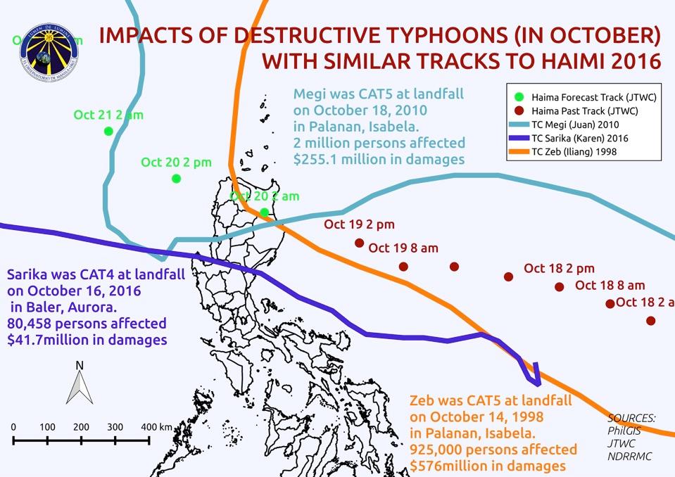
12 Megi was CAT5 at landfall on October 18, 2010 in Palanan, Isabela. 2 million persons affected $255.1 million in damages Sarika was CAT4 at landfall on October 16, 2016 in Baler, Aurora. 80,458 persons affected $41.7million in damages
13 Destructive typhoons with similar tracks to Haima (2016)
14 Destructive typhoons with similar tracks to Haima (2016)
Typhoon Haima (Lawin) Report #3 20 October 2016, 9.00AM PHT. Manila Observatory
 Report #3 20 October 2016, 9.00AM PHT. Manila Observatory") Typhoon Haima (Lawin) Report #3 20 October 2016, 9.00AM PHT Manila Observatory SUMMARY PAGASA reports eye of Super Typhoon Haima (Bagyong Lawin) located at 18.4 N, 120.3 E (as of 7 AM Oct 20) with max
Typhoon Haima (Lawin) Report #3 20 October 2016, 9.00AM PHT Manila Observatory SUMMARY PAGASA reports eye of Super Typhoon Haima (Bagyong Lawin) located at 18.4 N, 120.3 E (as of 7 AM Oct 20) with max
Typhoon Sarika (Karen) Report #2 15 October 2016, 9.00AM PHT. Manila Observatory
 Report #2 15 October 2016, 9.00AM PHT. Manila Observatory") Typhoon Sarika (Karen) Report #2 15 October 2016, 9.00AM PHT Manila Observatory SUMMARY Typhoon Sarika (Bagyong Karen), now upgraded to Cat 1, moving west-northwestward and expected to intensify to Cat
Typhoon Sarika (Karen) Report #2 15 October 2016, 9.00AM PHT Manila Observatory SUMMARY Typhoon Sarika (Bagyong Karen), now upgraded to Cat 1, moving west-northwestward and expected to intensify to Cat
EDNA L. JUANILLO Philippines
 Typhoon GLEnDA [RAMMASUN] EDNA L. JUANILLO Philippines TY GLENDA (RAMMASUN) (July 13-17, 2014) OTHER RELATED INFO It formed as a Tropical Depression (TD) over the Caroline Islands, Pacific Ocean, moving
Development of Tropical Storm Falcon (Meari) over the Philippines
 over the Philippines") Development of Tropical Storm Falcon (Meari) over the Philippines June 20-27, 2011 At the end of June, 2011, the Philippines were struck again by Tropical storm Falcon (Meari). After gaining strength over
Development of Tropical Storm Falcon (Meari) over the Philippines June 20-27, 2011 At the end of June, 2011, the Philippines were struck again by Tropical storm Falcon (Meari). After gaining strength over
Validation of COSMO model 24 h forecast rainfall using rain gauges estimated precipitation during occurrence of Typhoon Santi
 African Journal of Agricultural Science and Technology (AJAST) Vol. 3, Issue 6, pp. 286-293. June, 2015 http://www.oceanicjournals.org/ajast ISSN 2311-5882 2015 Oceanic Journals Full Length research Paper
The Weather and Climate Authority
 The Weather and Climate Authority EL NIÑO UPDATE & Climate Outlook (September 2015 February 2016) Prepared by: Climate Monitoring and Prediction Section (CLIMPS) CLIMATOLOGY & AGROMETEOROLOGY DIVISION
Overall Situation At 11:00 PM on 19 October, STY #LawinPH (international name: Haima) has made landfall over Baguio Pt., Peñablanca, Cagayan
 has made landfall over Baguio Pt., Peñablanca, Cagayan") TYPHOON LAWIN (HAIMA) Situation Report #6 24 October 2016, Monday, 6:30pm Overall Situation At 11:00 PM on 19 October, STY #LawinPH (international name: Haima) has made landfall over Baguio Pt., Peñablanca,
TYPHOON LAWIN (HAIMA) Situation Report #6 24 October 2016, Monday, 6:30pm Overall Situation At 11:00 PM on 19 October, STY #LawinPH (international name: Haima) has made landfall over Baguio Pt., Peñablanca,
Community-Based Flood Early Warning System (CBFEWS)
") Community-Based Flood Early Warning System (CBFEWS) Prepared by: Eng r. Hilario G. Esperanza Eng r.. Socrates F. Paat,, Jr. Flood Forecasting Branch PAGASA Weather Bureau Department of Science and Technology
Community-Based Flood Early Warning System (CBFEWS) Prepared by: Eng r. Hilario G. Esperanza Eng r.. Socrates F. Paat,, Jr. Flood Forecasting Branch PAGASA Weather Bureau Department of Science and Technology
The Role of PAGASA in Disaster Mitigation
 The Role of PAGASA in Disaster Mitigation Christopher F. Perez 2017 ACTS Workshop on Extreme Weather Forecast and Water Resource Management Hanoi, Vietnam September 26-27, 2017 Tropical Storm AMANG(Mekkhala),
UPDATE OF REGIONAL WEATHER AND SMOKE HAZE November 2016
 UPDATE OF REGIONAL WEATHER AND SMOKE HAZE November 2016 1. Review of Regional Weather Conditions in November 2016 1.1 Southwest Monsoon conditions prevailed on most days in October 2016 and the winds were
Rainfall-Flood Hazard along the Cagayan River in Carmen
 -Flood Hazard along the Cagayan River in Carmen Things to watch out for when rain falls intensity 12 December 2013, Cagayan de Oro City Hall 3 +1 main questions I What do we need to understand about rainfall
Current Details from the Joint Typhoon Warning Center
 Current Details from the Joint Warning Center COORDINATES: 19.6 north, 125.5 east (previous location: 17.9 north, 130.3 east) LOCATION: 737 kilometers (458 miles) southeast of Taipei, Taiwan MOVEMENT:
Republic of the Philippines
 MEMBER REPORT ESCAP/WMO Typhoon Committee 41 st Session 19-25 January 2009 Chiang Mai, Thailand Republic of the Philippines 1 CONTENTS Page I. Overview of tropical cyclones which have affected/impacted
SUMMARY OF THE 2011 TYPHOON SEASON
 ECONOMIC AND SOCIAL COMMISSION FOR ASIA AND THE PACIFIC AND WORLD METEOROLOGICAL ORGANIZATION WRD/TC.44/4.1 Add. 2 06 February 2012 Typhoon Committee Forty Fourth Session 06 to 12 February 2012 Hangzhou,
Tropical Cyclone Warning System in the Philippines
 Republic of the Philippines Department of Science and Technology PHILIPPINE ATMOSPHERIC GEOPHYSICAL AND ASTRONOMICAL SERVICES ADMINISTRAION (PAGASA) Science Garden Compound, Agham Road, Diliman, Quezon
TYPHOON HAIYAN. Known as typhoon Yolanda in the Philippines. Most powerful storm to make landfall in recorded history
 TYPHOON HAIYAN Known as typhoon Yolanda in the Philippines Most powerful storm to make landfall in recorded history Worst hit provinces: Leyte and Eastern Samar with a combined population of 2.3 M Experienced
Variations of Typhoon Activity in Asia - Global Warming and/or Natural Cycles?
 Variations of Typhoon Activity in Asia - Global Warming and/or Natural Cycles? Johnny Chan Guy Carpenter Asia-Pacific Climate Impact Centre City University of Hong Kong Tropical Cyclones Affecting the
TROPICAL CYCLONES. 21 entered the Philippine Area of Responsibility
 08 Highlights of Events Page of 5 TROPICAL CYCLONES SEISMIC ACTIVITIES entered the Philippine Area of Responsibility 8 made landfall 5 Tropical Depression Tropical Storm Category Category 4 Twenty-one
Philippine Natural Hazards, Landforms and Water Forms
 Philippine Natural Hazards, Landforms and Water Forms LEARNING OBJECTIVES: identify the major natural disasters in the country; evaluate the implications of different geographical features and changes
Response and Lesson Learned from Typhoon YOLANDA (HAIYAN)
") 9 th NARBO IWRM Training Tagaytay City May 12-19, 2014 Response and Lesson Learned from Typhoon YOLANDA (HAIYAN) Rene B. Paciente Weather Division, PAGASA Philippines OUTLINE 1. Meteorological Informations
9 th NARBO IWRM Training Tagaytay City May 12-19, 2014 Response and Lesson Learned from Typhoon YOLANDA (HAIYAN) Rene B. Paciente Weather Division, PAGASA Philippines OUTLINE 1. Meteorological Informations
Current Details from the National Hurricane Center (NHC)
") Current Watches and Warnings A Warning is in effect from San Blas to Punta San Telmo, Mexico A Warning is in effect from east of Punta San Telmo to Lazaro Cardenas, Mexico; north of San Blas to El Roblito,
Current Watches and Warnings A Warning is in effect from San Blas to Punta San Telmo, Mexico A Warning is in effect from east of Punta San Telmo to Lazaro Cardenas, Mexico; north of San Blas to El Roblito,
Introduction. Observed Local Trends. Temperature Rainfall Tropical Cyclones. Projections for the Philippines. Temperature Rainfall
 PAGASA-DOST ntroduction Observed Local Trends Temperature Rainfall Tropical Cyclones Projections for the Philippines Temperature Rainfall Climate Change ssue ncreased use of fossil fuel Global Warming
Current Details from the Joint Typhoon Warning Center
 Current Details from the Joint Warning Center COORDINATES: 10.2 north, 148.1 east (previous location: 10.1 north, 148.3 east) LOCATION: 520 kilometers (325 miles) southeast of Andersen Air Force Base,
GC Briefing. Weather Sentinel Tropical Storm Michael. Status at 8 AM EDT (12 UTC) Today (NHC) Discussion. October 11, 2018
 Today (NHC) Discussion. October 11, 2018") GC Briefing Weather Sentinel Tropical Storm Michael October 11, 2018 After making landfall as a high-end category-4 hurricane on the Florida Panhandle, Michael weakened to tropical storm status early this
GC Briefing Weather Sentinel Tropical Storm Michael October 11, 2018 After making landfall as a high-end category-4 hurricane on the Florida Panhandle, Michael weakened to tropical storm status early this
THE PROJECT FOR STUDY ON IMPROVEMENT OF BRIDGES THROUGH DISASTER MITIGATING MEASURES FOR LARGE SCALE EARTHQUAKES IN THE REPUBLIC OF THE PHILIPPINES
 THE REPUBLIC F THE PHILIPPINES DEPARTMENT F PUBLIC WRKS AND HIGHWAYS DPWH) THE PRJECT FR STUDY N IMPRVEMENT F BRIDGES THRUGH DISASTER MITIGATING MEASURES FR LARGE SCALE EARTHQUAKES IN THE REPUBLIC F THE
Current Details from the National Hurricane Center (NHC)
") Current Watches and Warnings A Hurricane Warning is in effect for U.S. Virgin Islands; British Virgin Islands; Puerto Rico, Culebra, and Vieques; Dominican Republic from Cabo Engano to Puerto Plata; Turks
Current Watches and Warnings A Hurricane Warning is in effect for U.S. Virgin Islands; British Virgin Islands; Puerto Rico, Culebra, and Vieques; Dominican Republic from Cabo Engano to Puerto Plata; Turks
UPDATE OF REGIONAL WEATHER AND SMOKE HAZE (September 2017)
") UPDATE OF REGIONAL WEATHER AND SMOKE HAZE (September 2017) 1. Review of Regional Weather Conditions in August 2017 1.1 Southwest Monsoon conditions continued to prevail in the region in August 2017. The
UPDATE OF REGIONAL WEATHER AND SMOKE HAZE (September 2017) 1. Review of Regional Weather Conditions in August 2017 1.1 Southwest Monsoon conditions continued to prevail in the region in August 2017. The
Comparative Study of Dvorak Analysis in the western North Pacific. Naohisa Koide and Shuji Nishimura Forecast Division, Japan Meteorological Agency
 Comparative Study of Dvorak Analysis in the western North Pacific Naohisa Koide and Shuji Nishimura Forecast Division, Japan Meteorological Agency 1. Introduction The United Nations Economic and Social
What Is This Module About? What Will You Learn From This Module?
 What Is This Module About? Did you know that the Philippines has about 22 typhoons every year? What parts of the country are often visited by typhoons? How much do you know about typhoons? In this module,
(April 7, 2010, Wednesday) Tropical Storms & Hurricanes Part 2
 Tropical Storms & Hurricanes Part 2") Lecture #17 (April 7, 2010, Wednesday) Tropical Storms & Hurricanes Part 2 Hurricane Katrina August 2005 All tropical cyclone tracks (1945-2006). Hurricane Formation While moving westward, tropical disturbances
Lecture #17 (April 7, 2010, Wednesday) Tropical Storms & Hurricanes Part 2 Hurricane Katrina August 2005 All tropical cyclone tracks (1945-2006). Hurricane Formation While moving westward, tropical disturbances
PAGASA s Expectations of New-generation Satellites for Hazard Monitoring
 Country Report Philippines PAGASA s Expectations of New-generation Satellites for Hazard Monitoring VICENTE P. PALCON, JR. (Assistant Weather Services Chief) Weather Division- PAGASA DOST Email: vppalconjr@pagasa.dost.gov.ph
UPDATE OF REGIONAL WEATHER AND SMOKE HAZE (December 2017)
") UPDATE OF REGIONAL WEATHER AND SMOKE HAZE (December 2017) 1. Review of Regional Weather Conditions for November 2017 1.1 In November 2017, Southeast Asia experienced inter-monsoon conditions in the first
UPDATE OF REGIONAL WEATHER AND SMOKE HAZE (December 2017) 1. Review of Regional Weather Conditions for November 2017 1.1 In November 2017, Southeast Asia experienced inter-monsoon conditions in the first
Variations of Typhoon Activity in Asia - Global Warming and/or Natural Cycles?
 Variations of Typhoon Activity in Asia - Global Warming and/or Natural Cycles? Johnny Chan Guy Carpenter Asia-Pacific Climate Impact Centre City University of Hong Kong Outline The common perception and
Probabilistic Evaluation of Prediction and Dynamics of Super Typhoon MEGI (2010)
") Probabilistic Evaluation of Prediction and Dynamics of Super Typhoon MEGI (2010) 6 November 2012 Chuanhai Qian 1, Fuqing Zhang 2, Yihong Duan 1 1 China Meteorological Administration 2 Pennsylvania State
Probabilistic Evaluation of Prediction and Dynamics of Super Typhoon MEGI (2010) 6 November 2012 Chuanhai Qian 1, Fuqing Zhang 2, Yihong Duan 1 1 China Meteorological Administration 2 Pennsylvania State
An Application of Hydrometeorological Information
 An Application of Hydrometeorological Information Weather-proof Café: Hydro-meteorological information in managing weather risks 17 19 November 2012 National Taiwan University, Chinese Taipei Nikos Viktor
Current Details from the National Hurricane Center (NHC)
") Current Watches and Warnings A Warning is in effect from Anclote River to the Okaloosa/Walton County Line; north of the Volusia/Brevard County line to the South Santee River A Surge Warning is in effect
Current Watches and Warnings A Warning is in effect from Anclote River to the Okaloosa/Walton County Line; north of the Volusia/Brevard County line to the South Santee River A Surge Warning is in effect
11/19/14. Chapter 11: Hurricanes. The Atmosphere: An Introduction to Meteorology, 12 th. Lutgens Tarbuck
 Chapter 11: Hurricanes The Atmosphere: An Introduction to Meteorology, 12 th Lutgens Tarbuck Lectures by: Heather Gallacher, Cleveland State University! Hurricanes: " Hurricanes are intense centers of
Current Details from the National Hurricane Center (NHC)
") Current Watches and Warnings A Hurricane Warning is in effect from Port Mansfield to Sargent, Texas A Warning is in effect from north of Sargent to High Island, Texas A Surge Warning is in effect from
Current Watches and Warnings A Hurricane Warning is in effect from Port Mansfield to Sargent, Texas A Warning is in effect from north of Sargent to High Island, Texas A Surge Warning is in effect from
Tropical Cyclone Megh
 Tropical Cyclone Megh 4-10 November 2015 NE Somalia and S Yemen Desert Locust Information Service FAO, Rome www.fao.org/ag/locusts Keith Cressman (Senior Locust Forecasting Officer) 04/11/2015 Tropical
A Climatology of the Extratropical Transition of Tropical Cyclones in the Western North Pacific
 A Climatology of the Extratropical Transition of Tropical Cyclones in the Western North Pacific Naoko KITABATAKE (Meteorological Research Institute / Japan Meteorological Agency) 1 Outline 1. Topic 1:
CASE STUDY: Tropical Cyclone Monica, April 2006
 CASE STUDY: Tropical Cyclone Monica, April 2006 By Mr Jeff Callaghan Retired Senior Severe Weather Forecaster, Bureau of Meteorology, Brisbane The track of tropical cyclone Monica (Figure 1) took it from
GPM Data Utilization (Philippines)
") 7 th GPM International Planning Workshop December 5-7, 2007 Tokyo, Japan GPM Data Utilization (Philippines) Flaviana Hilario Philippine Atmospheric, Geophysical & Astronomical Services Administration (PAGASA)
7 th GPM International Planning Workshop December 5-7, 2007 Tokyo, Japan GPM Data Utilization (Philippines) Flaviana Hilario Philippine Atmospheric, Geophysical & Astronomical Services Administration (PAGASA)
Covered Area Rainfall Event (5-8 October 2017) Tropical Storm Nate Excess Rainfall
 Tropical Storm Nate Excess Rainfall") Covered Area Rainfall Event (5-8 October 2017) Tropical Storm Nate Excess Rainfall Event Briefing Nicaragua 16 October 2017 Registered Office: CCRIF SPC c/o Sagicor Insurance Managers Ltd., 198 North Church
Covered Area Rainfall Event (5-8 October 2017) Tropical Storm Nate Excess Rainfall Event Briefing Nicaragua 16 October 2017 Registered Office: CCRIF SPC c/o Sagicor Insurance Managers Ltd., 198 North Church
Tropical Update. 5 PM EDT Tuesday, September 5, 2017 Hurricane Irma, Tropical Storm Jose, and Tropical Depression Thirteen
 Tropical Update 5 PM EDT Tuesday, September 5, 2017 Hurricane Irma, Tropical Storm Jose, and Tropical Depression Thirteen This update is intended for government and emergency response officials, and is
Current Details from the National Hurricane Center (NHC)
") Current Watches and Warnings A Hurricane Warning is in effect for the Dominican Republic from Cabo Engano to Puerto Plata; Turks and Caicos Islands and the Southeastern Bahamas A Warning is in effect for
Current Watches and Warnings A Hurricane Warning is in effect for the Dominican Republic from Cabo Engano to Puerto Plata; Turks and Caicos Islands and the Southeastern Bahamas A Warning is in effect for
Numerical Prediction of Tropical Cyclones (PAGASA Experience)
") Numerical Prediction of Tropical Cyclones (PAGASA Experience) BONIFACIO G. PAJUELAS Philippine Atmospheric, Geophysical and Astronomical Services Administration (PAGASA) Science Garden, Agham Road, Diliman,
Numerical Prediction of Tropical Cyclones (PAGASA Experience) BONIFACIO G. PAJUELAS Philippine Atmospheric, Geophysical and Astronomical Services Administration (PAGASA) Science Garden, Agham Road, Diliman,
P1.35 EVALUATING THE IMPACTS OF EXTRATROPICAL TRANSITIONING ON TYPHOON LOSSES VIA SYNOPTIC CASE STUDIES
 P1.35 EVALUATING THE IMPACTS OF EXTRATROPICAL TRANSITIONING ON TYPHOON LOSSES VIA SYNOPTIC CASE STUDIES Peter J. Sousounis* and Mélicie Desflots AIR Worldwide Corporation, Boston, MA 1. MOTIVATION FOR
Precipitation Structure and Processes of Typhoon Nari (2001): A Modeling Propsective
: A Modeling Propsective") Precipitation Structure and Processes of Typhoon Nari (2001): A Modeling Propsective Ming-Jen Yang Institute of Hydrological Sciences, National Central University 1. Introduction Typhoon Nari (2001) struck
Precipitation Structure and Processes of Typhoon Nari (2001): A Modeling Propsective Ming-Jen Yang Institute of Hydrological Sciences, National Central University 1. Introduction Typhoon Nari (2001) struck
Short Discription of NMHS Activity
 The 5th Meeting of the Coordinating Group of the RA II WIGOS Satellite Project 21 October, Vladivostok city, Russky Island, Russia Far Eastern Federal University FSM COUNTRY REPORT SOSTEN SOS, WSS OFFICE
Daily Operations Briefing. Sunday, October 19, :30 a.m. EDT
 Daily Operations Briefing Sunday, October 19, 2014 8:30 a.m. EDT Significant Activity: Oct 18-19 Significant Events: Hurricane Ana Tropical Activity: Atlantic Hurricane Gonzalo (FINAL) Eastern Pacific
Current Details from the National Hurricane Center (NHC)
") Current Watches and Warnings A Hurricane Warning is in effect from Port Mansfield to Sargent, Texas A Warning is in effect from north of Sargent to High Island, Texas; south of Port Mansfield, Texas to
Current Watches and Warnings A Hurricane Warning is in effect from Port Mansfield to Sargent, Texas A Warning is in effect from north of Sargent to High Island, Texas; south of Port Mansfield, Texas to
Current Details from the National Hurricane Center (NHC)
") Current Watches and Warnings A Hurricane Warning is in effect for Dominican Republic from Cabo Engano to the northern border with Haiti; Haiti from the northern border with the Dominican Republic to Le
Current Watches and Warnings A Hurricane Warning is in effect for Dominican Republic from Cabo Engano to the northern border with Haiti; Haiti from the northern border with the Dominican Republic to Le
The Philippines modified its Tropical Cyclone Warning System
 The Philippines modified its Tropical Cyclone Warning System Historical Background As an archipelago in Western North Pacific, the Philippines is exposed to tropical cyclones of varying intensity and impacts
Current Details from the National Hurricane Center (NHC)
") Current Watches and Warnings A Hurricane Warning is in effect for Dominican Republic from Cabo Engano to the northern border with Haiti; Haiti from the northern border with the Dominican Republic to Le
Current Watches and Warnings A Hurricane Warning is in effect for Dominican Republic from Cabo Engano to the northern border with Haiti; Haiti from the northern border with the Dominican Republic to Le
Improving Tropical Cyclone Forecasts by Assimilating Microwave Sounder Cloud-Screened Radiances and GPM precipitation measurements
 Improving Tropical Cyclone Forecasts by Assimilating Microwave Sounder Cloud-Screened Radiances and GPM precipitation measurements Hyojin Han a, Jun Li a, Mitch Goldberg b, Pei Wang a,c, Jinlong Li a,
Covered Area Rainfall Event (18-19 September 2017) Hurricane Maria Excess Rainfall
 Hurricane Maria Excess Rainfall") Covered Area Rainfall Event (18-19 September 2017) Hurricane Maria Excess Rainfall Event Briefing Barbados 28 September 2017 Registered Office: CCRIF SPC c/o Sagicor Insurance Managers Ltd., 198 North
Covered Area Rainfall Event (18-19 September 2017) Hurricane Maria Excess Rainfall Event Briefing Barbados 28 September 2017 Registered Office: CCRIF SPC c/o Sagicor Insurance Managers Ltd., 198 North
Introduction. Recent Developments in Observational Network. Analytical tools and Information Delivery system Limitations/Shortcomings
 Introduction Recent Developments in Observational Network Analytical tools and Information Delivery system Limitations/Shortcomings FACILITIES UPGRADING Weather Surveillance Radars Baguio DOST GIA ongoing
Covered Area Rainfall Event (18-20 October 2017) Excess Rainfall
 Excess Rainfall") Covered Area Rainfall Event (18-20 October 2017) Excess Rainfall Event Briefing Trinidad 29 October 2017 Registered Office: CCRIF SPC c/o Sagicor Insurance Managers Ltd., 198 North Church Street 2nd Floor
Covered Area Rainfall Event (18-20 October 2017) Excess Rainfall Event Briefing Trinidad 29 October 2017 Registered Office: CCRIF SPC c/o Sagicor Insurance Managers Ltd., 198 North Church Street 2nd Floor
Tropical Update. 5 AM EDT Wednesday, September 6, 2017 Hurricane Irma, Tropical Storm Jose, and Tropical Storm Katia
 Tropical Update 5 AM EDT Wednesday, September 6, 2017 Hurricane Irma, Tropical Storm Jose, and Tropical Storm Katia This update is intended for government and emergency response officials, and is provided
Tropical Cyclone Isaac (AL092012)
") Tropical Cyclone Isaac (AL092012) Event Briefing, Central Caribbean Impacts Caribbean Risk Managers Ltd Facility Supervisor 27 August 2012 Facility Supervisor: Caribbean Risk Managers Ltd Email: ccrif@ccrif.org
Tropical Cyclone Isaac (AL092012) Event Briefing, Central Caribbean Impacts Caribbean Risk Managers Ltd Facility Supervisor 27 August 2012 Facility Supervisor: Caribbean Risk Managers Ltd Email: ccrif@ccrif.org
Recent studies on tropical cyclone landfalling in China
 Recent studies on tropical cyclone landfalling in China Lei Xiaotu Shanghai Typhoon Institute CMA, Shanghai, China email: xtlei@21cn.com 1. Losses caused by tropical cyclones in China China is one of the
Current Details from the National Hurricane Center (NHC)
") Current Watches and Warnings A Hurricane Warning is in effect for Anguilla; Saba, St. Eustatius, and Sint Maarten; Saint Martin and Saint Barthelemy; British Virgin Islands; U.S. Virgin Islands; Puerto
Current Watches and Warnings A Hurricane Warning is in effect for Anguilla; Saba, St. Eustatius, and Sint Maarten; Saint Martin and Saint Barthelemy; British Virgin Islands; U.S. Virgin Islands; Puerto
7 December 2016 Tokyo Climate Center, Japan Meteorological Agency
 Summary of the 2016 Asian Summer Monsoon 7 December 2016 Tokyo Climate Center, Japan Meteorological Agency This report summarizes the characteristics of the surface climate and atmospheric/oceanographic
Current Details from the National Hurricane Center (NHC)
") Current Watches and Warnings A Hurricane Warning is in effect from South Santee River, South Carolina (SC) to Duck, North Carolina (NC); Albemarle and Pamlico Sounds A Hurricane Watch is in effect from
Current Watches and Warnings A Hurricane Warning is in effect from South Santee River, South Carolina (SC) to Duck, North Carolina (NC); Albemarle and Pamlico Sounds A Hurricane Watch is in effect from
Introduction. One way to monitor the status of this energy is though monitoring sea surface
 Sears 1 Understanding Hurricane Intensity Using Sea Surface Height and Temperature Information John Sears (Plymouth State University) Robbie Hood (NASA-MSFC) Frank LaFontaine (Raytheon) Abstract Warmer
Tropical Update. 5 PM EDT Thursday, September 7, 2017 Hurricane Irma, Hurricane Jose, and Hurricane Katia
 Tropical Update 5 PM EDT Thursday, September 7, 2017 Hurricane Irma, Hurricane Jose, and Hurricane Katia This update is intended for government and emergency response officials, and is provided for informational
Juban is faced with several major, major,major,major, major Natural Disasters and Hazards..
 Juban Hazards Juban Disaster Risk Reduction and Management Council (JMDRRMC) Juban Hazard Profile Juban is faced with natural multigeohazards / disasters. >>> Typhoons / Floods Bicol Region typhoon belt
The 2014 Atlantic Hurricane Season. What is New and What to Expect. Mark Chambers President & CEO ImpactWeather, Inc.
 The 2014 Atlantic Hurricane Season What is New and What to Expect Mark Chambers President & CEO ImpactWeather, Inc. Hurricane Climatology for the Gulf of Mexico A Look back at 2013 The outlook for this
Standardizing hurricane size descriptors for broadcast to the public
 Standardizing hurricane size descriptors for broadcast to the public Lori Drake, Hurricane Roadmap Project AMS 40th Conference on Broadcast Meteorology August 22-24, 2012, Boston, MA, Operational Forecasting
Storm Summary for Hurricane Joaquin
 Storm Summary for Hurricane Joaquin Wednesday, September 30, 2015 at 5 PM EDT (Output from Hurrevac, based on National Hurricane Center Forecast Advisory #12) Joaquin is currently a Category 1 hurricane
Major Hurricane Matthew Briefing Situation Overview
 Major Hurricane Matthew Briefing Situation Overview At 5 p.m. Tuesday, Category 4 Hurricane Matthew was about 860 miles South-Southeast of Mayport, Florida, moving north around 10 mph. Maximum sustained
Heavy Rain/Flooding September 8-10 Associated with Tropical Storm Etau
 Heavy Rain/Flooding September 8-10 Associated with Tropical Storm Etau Wx Files Vol.32 September 24, 2015 Tropical Storm Etau made landfall over the Chita Peninsula in Aichi just after 10:00 AM on September
ESCI 1010 Lab 7 Hurricanes (AKA: Typhoons, Cyclones)
") ESCI 1010 Lab 7 Hurricanes (AKA: Typhoons, Cyclones) Before Lab: Review pages 328-361 in your Weather and Climate textbook. Please pay special attention to the sections entitled: Hurricanes around the
ESCI 1010 Lab 7 Hurricanes (AKA: Typhoons, Cyclones) Before Lab: Review pages 328-361 in your Weather and Climate textbook. Please pay special attention to the sections entitled: Hurricanes around the
GC Briefing. Weather Sentinel Hurricane Florence. Status at 5 PM EDT (21 UTC) Today (NHC) Discussion. September 13, 2018
 Today (NHC) Discussion. September 13, 2018") GC Briefing September 13, 2018 Weather Sentinel Hurricane Florence Tropical storm conditions have been reported for areas of North Carolina and will continue to spread inland to the west and south. Hurricane
GC Briefing September 13, 2018 Weather Sentinel Hurricane Florence Tropical storm conditions have been reported for areas of North Carolina and will continue to spread inland to the west and south. Hurricane
Spatial Analysis of Income Growth in the Philippines: Evidence from Intra-Country Data (1988 to 2009)
") MPRA Munich Personal RePEc Archive Spatial Analysis of Income Growth in the Philippines: Evidence from Intra-Country Data (1988 to 2009) Dennis Mapa and Manuel Leonard Albis and Dorcas Mae Comandante and
MPRA Munich Personal RePEc Archive Spatial Analysis of Income Growth in the Philippines: Evidence from Intra-Country Data (1988 to 2009) Dennis Mapa and Manuel Leonard Albis and Dorcas Mae Comandante and
DAGUPAN CITY EXPERIENCES, GOOD PRACTICES, CHALLENGES AND LESSONS LEARNED ON DISASTER RISK MANAGEMENT
 DAGUPAN CITY EXPERIENCES, GOOD PRACTICES, CHALLENGES AND LESSONS LEARNED ON DISASTER RISK MANAGEMENT Reducing Vulnerability to Climate Change Impacts and Related Natural Disasters in East Asia 12 and 13
Marshall Alexander Forecaster Commonwealth of Dominica
 Marshall Alexander Forecaster Commonwealth of Dominica Dominica 2015 Impacts Tropical Storm Danny (August 24 th ) Tropical Storm Erika (August 27 th ) Tropical Storm Grace (Remnants) (September 10 th -11
Current Details from the National Hurricane Center (NHC)
") Current Watches and Warnings A Hurricane Warning is in effect for the Central Bahamas; Northwestern Bahamas (including the Abacos, Berry Islands, Eleuthera, Grand Bahama Island, and New Providence); The
Current Watches and Warnings A Hurricane Warning is in effect for the Central Bahamas; Northwestern Bahamas (including the Abacos, Berry Islands, Eleuthera, Grand Bahama Island, and New Providence); The
Hurricane Matthew. National Weather Service Wilmington NC. Steven Pfaff, WCM.
 Hurricane Matthew Threat Assessment for northeast South Carolina & southeast North Carolina National Weather Service Wilmington NC 515 PM EDT Monday October 3, 2016 Steven Pfaff, WCM Steven.Pfaff@noaa.gov
Features of the wind fields associated with Typhoon 0418 (Songda) compared with those of Typhoon 9119 (Mireille)
 compared with those of Typhoon 9119 (Mireille)") Features of the wind fields associated with Typhoon 0418 (Songda) compared with those of Typhoon 9119 (Mireille) by Fumiaki Fujibe 1, Naoko Kitabatake 2, Kotaro Bessho 2 and Shunsuke Hoshino 3 ABSTRACT
Features of the wind fields associated with Typhoon 0418 (Songda) compared with those of Typhoon 9119 (Mireille) by Fumiaki Fujibe 1, Naoko Kitabatake 2, Kotaro Bessho 2 and Shunsuke Hoshino 3 ABSTRACT
MEMBER REPORT. Philippines
 MEMBER REPORT ESCAP/WMO Typhoon Committee 11th Integrated Workshop Philippines Cebu City, Philippines 24 28 October 2016 CONTENTS I. Overview of tropical cyclones which have affected/impacted Member s
Current Details from the National Hurricane Center (NHC)
") Current Watches/Warnings A Hurricane Warning is in effect from Surf City, North Carolina to the North Carolina/Virginia border; Pamlico Sound; Eastern Albemarle Sound A Hurricane Watch is in effect from
Current Watches/Warnings A Hurricane Warning is in effect from Surf City, North Carolina to the North Carolina/Virginia border; Pamlico Sound; Eastern Albemarle Sound A Hurricane Watch is in effect from
DRRM in the Philippines: DRRM Projects, Geoportals and Socio-Economic Integration
 Regional workshop on Geo-referenced information system for improving disaster risk preparedness and management in Asia and the Pacific 26-27 June 2014, UNCC, Bangkok, Thailand DRRM in the Philippines:
Remote Sensing of Illegal Black Sand Mining in the Philippines
 Remote Sensing of Illegal Black Sand Mining in the Philippines Sara Kerosky (UCSD) Estelle Chaussard (UCB) CEGA Behavioral Sensing Challenge 2014 What is black sand? Blacksand,ormagne0te,isatypeofironore.
Saturday, October 6, :30 a.m. EDT
 Saturday, October 6, 2018 8:30 a.m. EDT Significant Activity Oct 5-6 Significant Events: None Tropical Activity: Atlantic Tropical Storm Leslie; Disturbance 1 (High: 90%) Eastern Pacific Hurricane Sergio
Lecture 18 Hurricanes
 Lecture 18 Hurricanes Part I Structure and Climatology What is a hurricane? What is the structure or anatomy of a hurricane? How to build a hurricane - hurricane energy Hurricane climatology - when and
On the presence of tropical vortices over the Southeast Asian Sea- Maritime Continent region
 Technical Conference of 50 th Annual Session of Typhoon Committee 2018 On the presence of tropical vortices over the Southeast Asian Sea- Maritime Continent region Nguyen Dang-Quang 1, James Renwick 2,
Current Details from the National Hurricane Center (NHC)
") Current Watches and Warnings A Hurricane Warning is in effect from Port Mansfield to Matagorda, Texas A Warning is in effect from north of Matagorda to High Island, Texas; south of Port Mansfield, Texas
Current Watches and Warnings A Hurricane Warning is in effect from Port Mansfield to Matagorda, Texas A Warning is in effect from north of Matagorda to High Island, Texas; south of Port Mansfield, Texas
Daily Operations Briefing. Sunday, October 5, :30 a.m. EDT
 Daily Operations Briefing Sunday, October 5, 2014 8:30 a.m. EDT Significant Activity: Oct 4-5 Significant Events: Typhoon 19W (Vongfong) Tropical Activity: Atlantic Tropical Cyclone Activity is not expected
Impact of Intraseasonal Variations to the Spatial Distribution of Coastal Heavy Rainbands Intensity During HARIMAU IOP 2011 in the West Sumatera
 Impact of Intraseasonal Variations to the Spatial Distribution of Coastal Heavy Rainbands Intensity During HARIMAU IOP 2011 in the West Sumatera Ardhi Adhary Arbain, Yekti Galihselowati Agency for the
MEMBER REPORT. ESCAP/WMO Typhoon Committee 9 th Integrated Workshop PAGASA, PHILIPPINES
 MEMBER REPORT ESCAP/WMO Typhoon Committee 9 th Integrated Workshop PAGASA, PHILIPPINES 20 24 October 2014 ESCAP UN Conference Center, Bangkok, Thailand CONTENTS I. Overview of tropical cyclones which have
ERTH 365 Homework #2: Hurricane Harvey. 100 points
 ERTH 365 Homework #2: Hurricane Harvey 100 points Due by 6pm, Tuesday 30 October 2018, ELECTRONIC SUBMISSON BY EMAIL ONLY BY 6PM (send to klevey@sfsu.edu) (acceptable formats: MS Word, Google Doc, plain
Foundations of Earth Science, 6e Lutgens, Tarbuck, & Tasa
 Foundations of Earth Science, 6e Lutgens, Tarbuck, & Tasa Weather Patterns and Severe Weather Foundations, 6e - Chapter 14 Stan Hatfield Southwestern Illinois College Air masses Characteristics Large body
Hurricane Harvey the Name says it all. by Richard H. Grumm and Charles Ross National Weather Service office State College, PA
 Hurricane Harvey the Name says it all by Richard H. Grumm and Charles Ross National Weather Service office State College, PA 16803. 1. Overview Hurricane Harvey crossed the Texas coast (Fig. 1) as a category
Huracan: evil Taino & Mayan god of winds & destruction
 Huracan: evil Taino & Mayan god of winds & destruction Profile of a Tropical Cyclone! Hurricane = typhoon = cyclone! All different words for the same thing Eye: clear area in the center Eyewall: clouds
WEDNESDAY 30 TH AUGUST, :57 p.m. Tropical Storm Irma forms in the Atlantic. Don t let your guard down, always #Be Ready.
 Chapter 1 - The Set Up In the days leading up to Irma a series of composed and sobering text messages, presented in truncated form below, from Department of Disaster Management warned us of the pending
Current Details from the Joint Typhoon Warning Center
 Current Details from the Joint Warning Center COORDINATES: 25.0 north, 119.1 east (previous location: 23.3 north, 123.7 east) LOCATION: 245 kilometers (150 miles) west of Taipei, Taiwan MOVEMENT: northwestward
Extreme Winds in the Western North Pacific. Søren Ott
 in the Western North Pacific Søren Ott Outline Tropical cyclones and wind turbines Modelling extreme winds Validation Conclusions Cat. 4 tropical cyclone IVAN 15 Sept 2004 at landfall near Luisiana, USA
Disaster Risk Management in India. Kamal Kishore New Delhi, 27 October 2016
 Disaster Risk Management in India Kamal Kishore New Delhi, 27 October 2016 Hazard, Exposure and Vulnerability Disaster Prevention Mitigation Hurricane Matthew: Cuba & Haiti Emergency Response Coordination
LECTURE #18: Hurricane Damage, Monitoring & Case Study
 GEOL 0820 Ramsey Natural Disasters Spring, 2018 LECTURE #18: Hurricane Damage, Monitoring & Case Study Date: 27 March 2018 I. Exam II grades now posted online o high: 98, low: 46, average: 80 (~3 points