Community-Based Flood Early Warning System (CBFEWS)
|
|
|
- Nicholas Kelly
- 6 years ago
- Views:
Transcription
1 Community-Based Flood Early Warning System (CBFEWS) Prepared by: Eng r. Hilario G. Esperanza Eng r.. Socrates F. Paat,, Jr. Flood Forecasting Branch PAGASA Weather Bureau Department of Science and Technology Philippines
2 Outline of Presentation Weather-causing phenomena Climate of the Philippines Rationale of CBFEWS Activities Progress of implementation
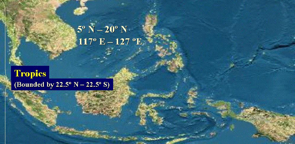
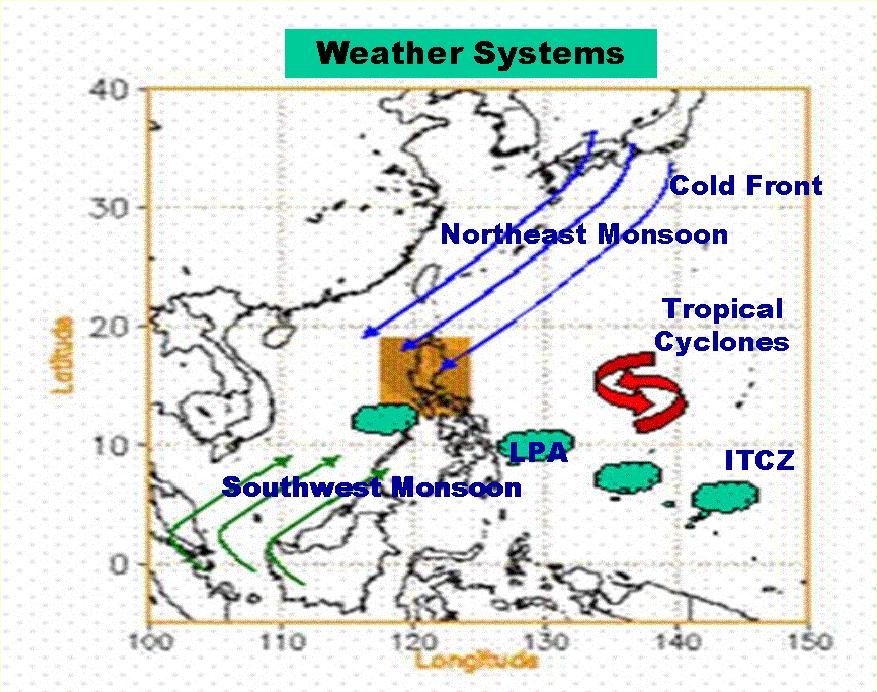
3 The climate of the Philippines is influenced by the complex interactions of the various factors such as : Geographic location and topography Ocean currents Semi-permanent cyclones and anti-cyclones Principal Air Streams Linear systems Tropical Cyclones

4
5
6
7 CLASSIFICATION OF TROPICAL CYCLONES TROPICAL DEPRESSION - maximum sustained winds is from 45 to 63 kph. TROPICAL STORM - maximum sustained winds is from 64 to 117 kph. TYPHOON maximum sustained winds is 118 kph and higher. (Super Typhoon- used by Joint Tropical Warning Center when max. winds is greater than 215 kph). Public Storm Warning Signals #1- Wind speed kph in 36 hours #2- Wind speed kph in 24 hours #3- Wind speed kph in 18 hours #4- Wind speed greater than 185 kph in 12 hours

8

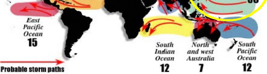
9 Frequency of Tropical Cyclone Occurrence Typhoon season is from June to December although no month is typhoon free Peak months are July, August and September
10 THE PHILIPPINE AREA OF RESPONSIBILITY [PAR] ONCE A TROPICAL CYCLONE IS INSIDE THE PAR, IT IS GIVEN A PILIPINO NAME
 Second Quarter")


 OCT NOV OCT DEC NOV DEC NOV")
11 Average Tropical Cyclone Tracks First Quarter (Jan,Feb,Mar) Second Quarter (April, May, June) May Apr Jun May MAR JAN FEB JAN Apr Jun Jun Apr MAR MAR JAN FEB May Apr JUL AUG SEP NOV DEC AUG SEP JUL AUG AUG SEP JUL AUG Third Quarter (July, Aug, Sep) Fourth Quarter (Oct, Nov, Dec) OCT NOV OCT DEC NOV DEC NOV DEC DEC NOV

12 Philippine Climate Classification
13 Every year ~ 20 tropical cyclones enter the Philippine Area of Responsibility (PAR) ~ 9 make landfall Affected by monsoons & other weather systems Casualties and damages due to hydrometeorological hazards are high
14
15

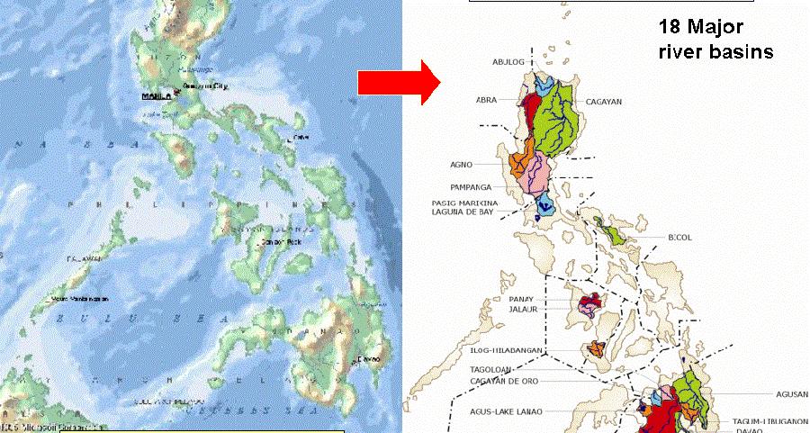
16 Monitored Basins and Dams


17
18 Community Based Flood Early Warning System (CBEWS) Hazard Mapping and Assessment for Effective Community Based Disaster Risk Management (READY Project funded by UNDP)


19 The Community-based Concept
20 Why pursue a CBFEWS? It empowers local government units (LGU s) and the communities to protect themselves against floods. They are in the best position to undertake preparedness measures against floods. It is sustainable.

21 Activities in CBFEWS 1. Coordination with LGUs & other institutions (consultation meetings)

 and")
22 Activities in CBFEWS 2. Survey (tabletop) and design of network


23 Activities in CBFEWS 3. Site survey (ocular inspection) (Verification of identified sites for accessibility, communication, etc. get coordinates)


24 Activities in CBFEWS 4. Procurement / fabrication of equipment


25 Activities in CBFEWS 5. Procurement / fabrication of equipment AUTOMATIC RAIN GAUGE Battery-operated LCD Monitor (inside the building)


26 Activities in CBFEWS 6. Procurement / fabrication of equipment Water level gauge template
")
27 Activities in CBFEWS 7. Installation of equipment (raingauge) Standard Raingauge

 Rain")
28 Activities in CBFEWS 8. Installation of equipment (automatic raingauge) Rain Gauge

 LADDER CUT-OUT")
 Standard")
29 Activities in CBFEWS 9. Installation of equipment (water level gauge) LADDER CUT-OUT PATTERN (MADE OF CARDBOARD) Standard Raingauge SPRAY PAINT


30 Activities in CBFEWS 10. Discharge Measurement & Cross-sectioning (hydrographic survey measurement) River cross-sectioning activities are undertaken to establish assessment levels for flood warning. Discharge or river flow measurement


31 Activities in CBFEWS 11. Training of LGU personnel & members of community On-the-job training Formal training (lecture)

32 Activities in CBFEWS 12. Dry run / IEC / Operationalization Rainfall Water level Flow of Data / Information System RR Stn.3 RR Stn.2 WL Stn. 2 RR Stn 1 Operation center Flood Warning WL Stn.1 Community
 ORDINANCE NO 2005-01 01 entitled, AN ORDINANCE PROVIDING AN ANNUAL")
33 Activities in CBFEWS 13. MOA signing, passage of local ordinance in support of the CBEWS LEGISLATIVE SUPPORT (Dumangas( Dumangas,, Iloilo) ORDINANCE NO entitled, AN ORDINANCE PROVIDING AN ANNUAL APPROPRIATION FOR THE MAINTENANCE AND OTHER OPERATIONAL EXPENSES OF THE COMMUNITY-BASED FLOOD AND DROUGHT FORECASTING AND WARNING SYSTEM IN DUMANGAS, ILOILO.
34 Responsibilities of Institutions Provincial Government 1. Coordinate with municipalities in the establishment of CBEWS; 2. Assist PAGASA in identifying the suitable communication facilities/network for the CBEWS; 3. Organize trainings/meetings for CBEWS; 4. Facilitate the signing of the MOA among stakeholders; 5. Monitor and ensure the smooth implementation of the project and the smooth operation of the CBEWS; 6. Assist the municipalities in the allocation of funds for operation & maintenance of the CBEWS through the enactment of a municipal ordinance; and 7. Provide all observed data and information to PAGASA on a monthly basis.
35 Responsibilities of Institutions Municipalities 1. Assist PAGASA in the site survey, fabrication & installation of rainfall, water level and tide gauges & flood markers & hydrographic surveys; 2. Ensure the implementation of the project by signing the Memorandum of agreement; 3. Provide two observers per station to be trained by PAGASA; 4. Operate, maintain and secure the installed equipment; 5. Ensure the sustainability of the system through the passage of an ordinance in support of the CBEWS 6. Prepare and issue flood advisories/warnings to threatened communities; and 7. Provide real-time data and warnings to the Provincial Government and the designated operation center.
36 PAGASA Responsibilities of Institutions 1. Coordinate with the LGUs and concerned institutions in the establishment of the CBEWS. 2. Conduct survey and design monitoring network in coordination with LGUs. 3. Install monitoring equipment in collaboration with LGUs. 4. Train LGUs in the fabrication and installation of monitoring instruments. 5. Train LGUs on observation, recording and transmission of data. 6. Train Municipal Planning and Development Officer & other key municipal personnel in the analysis of data & preparation of warnings/advisories. 7. Conduct monitoring and evaluation of CBEWS.
37 Responsibilities of Institutions OCD Regional Office 1. Assist PAGASA in the coordination of the project with LGUs and other agencies. 2. Assist in information & warning dissemination. 3. Assist in monitoring & evaluation of CBEWS and provide data on casualties and damages. DOST Regional Office 1. Assist PAGASA in the coordination of the project with LGUs and other agencies. 2. Assist in information & warning dissemination. 3. Assist in monitoring & evaluation of CBEWS.
 Initiative and")


38 1. Lower Pampanga River Basin (Bulacan( Bulacan) Initiative and funded by the Provincial Government of Bulacan Operational in June 2005 Transmission of data & warnings: SMS/voice Memorandum of Agreement (MOA) & Local ordinance enacted Project cost ~PhP1.0M Installation of Raingauge Gauge Installation of Water Level Gauge Citation was given to PAGASA by the Prov l. Gov t. of Bulacan PID on flood disaster mitigation to members of DCCs
 Transmission of data & warnings: SMS/voice")

39 2. Jalaur River Basin Initiative of Municipal Government (Dumangas, Iloilo) Commenced in June 2003 Funding: National Disaster Coordinating Council (NDCC) Transmission of data & warnings: SMS/voice Project cost ~PhP1.0M Activities undertaken: Survey and design of network Fabrication and installation of rainfall and water level gauges MOA signed and local ordinance enacted Preparation of operations manual

40 3. Agno-allied River Basins (Province of Pangasinan) Initiative of Provincial Government Commenced in September 2004 Funded by JICA Transmission of data & warnings: radio Project cost ~ PhP1.9M Activities undertaken: Survey and design network Installation of rainfall and water level gauges and relay stations Operations manual Training/Seminar/Dry-Run MOA signed and local ordinance enacted Dry-run of CBFEWS
 Survey and design of network Procurement & fabrication of equipment.")
41 4. Surigao del Sur River Basins Commenced April 01, 2006 Funded by UNDP (AusAID) with counterpart from LGUs Coordination meetings with LGU s & other institutions conducted Draft Memorandum of Agreement under review by LGUs & gov t. institutions (OCD & DOST CARAGA) Survey and design of network Procurement & fabrication of equipment. Installation of the equipment IEC/Dry-run
42 5. Surigao del Norte River Basins Commenced June 2006 Funded by UNDP (AusAID) with counterpart from LGUs Coordination meetings with LGU s & other institutions June 15, 2006 Draft Memorandum of Agreement under review by LGUs & gov t. institutions (OCD & DOST CARAGA) Survey and design of network completed Procurement & fabrication of equipment Installation of equipment IEC / Dry-Run (1:50 Topographic Maps) *Contours *Spot elevations 12 Municipalities (excluding Dinagat Is.) 11 River Basins 11 Major River & Creeks (Lengths~8 to 38 kms)
 Abra river basin (Abra & Ilocos Sur) Nueva Viscaya Agno river basin")
 Antique Aurora Bicol river basin (Camarines Sur, Camarines Norte &")

43 Target areas of CBFEWS Cagayan river basin (Cagayan, Isabela and Nueva Viscaya) Abra river basin (Abra & Ilocos Sur) Nueva Viscaya Agno river basin (Beguet, Pangasinan & Tarlac) Pampanga river basin (Pampanga, Nueva Ecija and Bulacan) Antique Aurora Bicol river basin (Camarines Sur, Camarines Norte & small part of Albay) N & E Samar Leyte Island (Leyte & So Leyte) Telemetered On-going Proposed Operational Bohol Zamboanga del Sibuguey Surigao del Norte Surigao del Sur


44 For additional information, VISIT us at THANK YOU tracking the sky... helping the country
EDNA L. JUANILLO Philippines
 Typhoon GLEnDA [RAMMASUN] EDNA L. JUANILLO Philippines TY GLENDA (RAMMASUN) (July 13-17, 2014) OTHER RELATED INFO It formed as a Tropical Depression (TD) over the Caroline Islands, Pacific Ocean, moving
Typhoon Haima (Lawin) Report #3 20 October 2016, 9.00AM PHT. Manila Observatory
 Report #3 20 October 2016, 9.00AM PHT. Manila Observatory") Typhoon Haima (Lawin) Report #3 20 October 2016, 9.00AM PHT Manila Observatory SUMMARY PAGASA reports eye of Super Typhoon Haima (Bagyong Lawin) located at 18.4 N, 120.3 E (as of 7 AM Oct 20) with max
Typhoon Haima (Lawin) Report #3 20 October 2016, 9.00AM PHT Manila Observatory SUMMARY PAGASA reports eye of Super Typhoon Haima (Bagyong Lawin) located at 18.4 N, 120.3 E (as of 7 AM Oct 20) with max
The Weather and Climate Authority
 The Weather and Climate Authority EL NIÑO UPDATE & Climate Outlook (September 2015 February 2016) Prepared by: Climate Monitoring and Prediction Section (CLIMPS) CLIMATOLOGY & AGROMETEOROLOGY DIVISION
TYPHOON HAIYAN. Known as typhoon Yolanda in the Philippines. Most powerful storm to make landfall in recorded history
 TYPHOON HAIYAN Known as typhoon Yolanda in the Philippines Most powerful storm to make landfall in recorded history Worst hit provinces: Leyte and Eastern Samar with a combined population of 2.3 M Experienced
"STUDY ON THE VARIABILITY OF SOUTHWEST MONSOON RAINFALL AND TROPICAL CYCLONES FOR "
 "STUDY ON THE VARIABILITY OF SOUTHWEST MONSOON RAINFALL AND TROPICAL CYCLONES FOR 2001 2010" ESPERANZA O. CAYANAN, Ph.D. Chief, Climatology & Agrometeorology R & D Section Philippine Atmospheric Geophysical
COUNTRY PRESENTATION ON MR JAYNAL ABEDIN JOINT SECRETARY ( WORKS & DEVELOPMENT ) MINISTRY OF DEFENCE
 MINISTRY OF DEFENCE") COUNTRY PRESENTATION ON By MR JAYNAL ABEDIN JOINT SECRETARY ( WORKS & DEVELOPMENT ) MINISTRY OF DEFENCE Bangladesh Geographical Location of Bangladesh Bangladesh Country at a Glance Physical Features 1,230
COUNTRY PRESENTATION ON By MR JAYNAL ABEDIN JOINT SECRETARY ( WORKS & DEVELOPMENT ) MINISTRY OF DEFENCE Bangladesh Geographical Location of Bangladesh Bangladesh Country at a Glance Physical Features 1,230
Response and Lesson Learned from Typhoon YOLANDA (HAIYAN)
") 9 th NARBO IWRM Training Tagaytay City May 12-19, 2014 Response and Lesson Learned from Typhoon YOLANDA (HAIYAN) Rene B. Paciente Weather Division, PAGASA Philippines OUTLINE 1. Meteorological Informations
9 th NARBO IWRM Training Tagaytay City May 12-19, 2014 Response and Lesson Learned from Typhoon YOLANDA (HAIYAN) Rene B. Paciente Weather Division, PAGASA Philippines OUTLINE 1. Meteorological Informations
Chiang Rai Province CC Threat overview AAS1109 Mekong ARCC
 Chiang Rai Province CC Threat overview AAS1109 Mekong ARCC This threat overview relies on projections of future climate change in the Mekong Basin for the period 2045-2069 compared to a baseline of 1980-2005.
On the presence of tropical vortices over the Southeast Asian Sea- Maritime Continent region
 Technical Conference of 50 th Annual Session of Typhoon Committee 2018 On the presence of tropical vortices over the Southeast Asian Sea- Maritime Continent region Nguyen Dang-Quang 1, James Renwick 2,
Development of Tropical Storm Falcon (Meari) over the Philippines
 over the Philippines") Development of Tropical Storm Falcon (Meari) over the Philippines June 20-27, 2011 At the end of June, 2011, the Philippines were struck again by Tropical storm Falcon (Meari). After gaining strength over
Development of Tropical Storm Falcon (Meari) over the Philippines June 20-27, 2011 At the end of June, 2011, the Philippines were struck again by Tropical storm Falcon (Meari). After gaining strength over
Typhoon Haima (Lawin) Report #4 20 October 2016, 3.00PM PHT. Manila Observatory
 Report #4 20 October 2016, 3.00PM PHT. Manila Observatory") Typhoon Haima (Lawin) Report #4 20 October 2016, 3.00PM PHT Manila Observatory SUMMARY PAGASA reports eye of Super Typhoon Haima (Bagyong Lawin) located at 18.5 N, 119.7 E (as of 10 AM Oct 20) with max
Typhoon Haima (Lawin) Report #4 20 October 2016, 3.00PM PHT Manila Observatory SUMMARY PAGASA reports eye of Super Typhoon Haima (Bagyong Lawin) located at 18.5 N, 119.7 E (as of 10 AM Oct 20) with max
Tropical Cyclone Warning System in the Philippines
 Republic of the Philippines Department of Science and Technology PHILIPPINE ATMOSPHERIC GEOPHYSICAL AND ASTRONOMICAL SERVICES ADMINISTRAION (PAGASA) Science Garden Compound, Agham Road, Diliman, Quezon
JCOMM-CHy Coastal Inundation Forecasting Demonstration Project (CIFDP)
") WMO World Meteorological Organization Working together in weather, climate and water JCOMM-CHy Coastal Inundation Forecasting Demonstration Project (CIFDP) Coastal Flooding & Vulnerable Populations Coastal
WMO World Meteorological Organization Working together in weather, climate and water JCOMM-CHy Coastal Inundation Forecasting Demonstration Project (CIFDP) Coastal Flooding & Vulnerable Populations Coastal
COUNTRY REPORT. Jakarta. July, th National Directorate of Meteorology and Geophysics of Timor-Leste (DNMG)
") The Southeastern Asia-Oceania Flash Flood COUNTRY REPORT Jakarta. July, 10-12 th 2017 National Directorate of Meteorology and Geophysics of Timor-Leste (DNMG) Carla Feritas and Crisostimo Lobato Democratic
The Southeastern Asia-Oceania Flash Flood COUNTRY REPORT Jakarta. July, 10-12 th 2017 National Directorate of Meteorology and Geophysics of Timor-Leste (DNMG) Carla Feritas and Crisostimo Lobato Democratic
PAGASA s Expectations of New-generation Satellites for Hazard Monitoring
 Country Report Philippines PAGASA s Expectations of New-generation Satellites for Hazard Monitoring VICENTE P. PALCON, JR. (Assistant Weather Services Chief) Weather Division- PAGASA DOST Email: vppalconjr@pagasa.dost.gov.ph
Typhoon Sarika (Karen) Report #2 15 October 2016, 9.00AM PHT. Manila Observatory
 Report #2 15 October 2016, 9.00AM PHT. Manila Observatory") Typhoon Sarika (Karen) Report #2 15 October 2016, 9.00AM PHT Manila Observatory SUMMARY Typhoon Sarika (Bagyong Karen), now upgraded to Cat 1, moving west-northwestward and expected to intensify to Cat
Typhoon Sarika (Karen) Report #2 15 October 2016, 9.00AM PHT Manila Observatory SUMMARY Typhoon Sarika (Bagyong Karen), now upgraded to Cat 1, moving west-northwestward and expected to intensify to Cat
Role of Hydro-Met Services in Disaster Risk Management
 Role of Hydro-Met Services in Disaster Risk Management Tshewang Rigzin (Mr) National Centre for Hydrology and Meteorology, Bhutan 30 th November 2017 Outline Vision and Mission Functions related to Disaster
TROPICAL CYCLONES. 21 entered the Philippine Area of Responsibility
 08 Highlights of Events Page of 5 TROPICAL CYCLONES SEISMIC ACTIVITIES entered the Philippine Area of Responsibility 8 made landfall 5 Tropical Depression Tropical Storm Category Category 4 Twenty-one
An Application of Hydrometeorological Information
 An Application of Hydrometeorological Information Weather-proof Café: Hydro-meteorological information in managing weather risks 17 19 November 2012 National Taiwan University, Chinese Taipei Nikos Viktor
The Role of PAGASA in Disaster Mitigation
 The Role of PAGASA in Disaster Mitigation Christopher F. Perez 2017 ACTS Workshop on Extreme Weather Forecast and Water Resource Management Hanoi, Vietnam September 26-27, 2017 Tropical Storm AMANG(Mekkhala),
Coastal Inundation Forecasting and Community Response in Bangladesh
 WMO Coastal Inundation Forecasting and Community Response in Bangladesh Bapon (SHM) Fakhruddin Nadao Kohno 12 November 2015 System Design for Coastal Inundation Forecasting CIFDP-PSG-5, 14-16 May 2014,
Understanding Climate Change Scenarios and its Implications to to Agriculture Livelihoods
 Understanding Climate Change Scenarios and its Implications to to Agriculture Livelihoods Presented at the The Workshop for Capacity Building on Climate Change Impact Assessments and Adaptation Planning
JOINT BRIEFING TO THE MEMBERS. El Niño 2018/19 Likelihood and potential impact
 JOINT BRIEFING TO THE MEMBERS El Niño 2018/19 Likelihood and potential impact CURRENT EL NIÑO OUTLOOK (SEPTEMBER 2018) CPC/IRI ENSO Forecast from September. Red bars denote probability of an El Nino developing
Improvement of Hazard Assessment and Management in the Philippines
 Improvement of Hazard Assessment and Management in the Philippines (2014 Summer Training Course for Slope Land Disaster Reduction) Ian Alejandrino (Philippines) Nguyen Manh Hieu (Vietnam) Presentation
DAGUPAN CITY EXPERIENCES, GOOD PRACTICES, CHALLENGES AND LESSONS LEARNED ON DISASTER RISK MANAGEMENT
 DAGUPAN CITY EXPERIENCES, GOOD PRACTICES, CHALLENGES AND LESSONS LEARNED ON DISASTER RISK MANAGEMENT Reducing Vulnerability to Climate Change Impacts and Related Natural Disasters in East Asia 12 and 13
The Huong River the nature, climate, hydro-meteorological issues and the AWCI demonstration project
 The Huong River the nature, climate, hydro-meteorological issues and the AWCI demonstration project 7th GEOSS AP Symposium, the AWCI parallel session May 27, 214, Tokyo National Centre for Hydro-Meteorological
CLIMATE SERVICES for the AGRICUTURAL SECTOR in the PHILIPPINES
 CLIMATE SERVICES for the AGRICUTURAL SECTOR in the PHILIPPINES EDNA L. JUANILLO Weather Services Chief, PAGASA Technical Conference on Future Challenges and Opportunities in Agricultural Meteorology 16-17
Government of Sultanate of Oman Public Authority of Civil Aviation Directorate General of Meteorology. National Report To
 Government of Sultanate of Oman Public Authority of Civil Aviation Directorate General of Meteorology National Report To Panel on Tropical Cyclones in the Bay of Bengal And Arabian Sea 43rd Session, India
Study of Hydrometeorology in a Hard Rock Terrain, Kadirischist Belt Area, Anantapur District, Andhra Pradesh
 Open Journal of Geology, 2012, 2, 294-300 http://dx.doi.org/10.4236/ojg.2012.24028 Published Online October 2012 (http://www.scirp.org/journal/ojg) Study of Hydrometeorology in a Hard Rock Terrain, Kadirischist
Hurricane Basics and Preparedness. Jim Weyman Director, Central Pacific Hurricane Center Phone Office:
 Hurricane Basics and Preparedness Jim Weyman Director, Central Pacific Hurricane Center Phone Office: 973-5270 james.weyman@noaa.gov United States Hurricane/Typhoon Centers National Hurricane Center, Miami
National Report on Weather Forecasting Service
 MINISTRY OF WATER RESOURCES AND METEOROLOGY DEPARTMENT OF METEOROLOGY, CAMBODIA National Report on Weather Forecasting Service Tokyo, 11-15 March 2014 Department of Meteorology, Cambodia Presentation Outline
Republic of Mozambique
 Republic of Mozambique Second Expert's Symposium on Multi-Hazard Early Warning Systems with focus on the Role of National Meteorological and Hydrological Services 5-7 May 2009, Toulouse France 1. Background
WHEN IS IT EVER GOING TO RAIN? Table of Average Annual Rainfall and Rainfall For Selected Arizona Cities
 WHEN IS IT EVER GOING TO RAIN? Table of Average Annual Rainfall and 2001-2002 Rainfall For Selected Arizona Cities Phoenix Tucson Flagstaff Avg. 2001-2002 Avg. 2001-2002 Avg. 2001-2002 October 0.7 0.0
GAMINGRE 8/1/ of 7
 FYE 09/30/92 JULY 92 0.00 254,550.00 0.00 0 0 0 0 0 0 0 0 0 254,550.00 0.00 0.00 0.00 0.00 254,550.00 AUG 10,616,710.31 5,299.95 845,656.83 84,565.68 61,084.86 23,480.82 339,734.73 135,893.89 67,946.95
Saiful Islam Anisul Haque
 Workshop on Disaster Prevention/Mitigation Measures against Floods and Storm Surges in Bangladesh on 17-21 November, 2012, in Kyoto University, Japan Component 2: Flood disaster risk assessment and mitigation
Overview of Philippine Geohazards Programs
 Overview of Philippine Geohazards Programs 53 rd CCOP Annual Session CCOP-IUGS Task Group on Geohazards Joint Seminar Cebu City, PHILIPPINES October 18, 2017 Renato U. Solidum, Jr. Department of Science
DRRM in the Philippines: DRRM Projects, Geoportals and Socio-Economic Integration
 Regional workshop on Geo-referenced information system for improving disaster risk preparedness and management in Asia and the Pacific 26-27 June 2014, UNCC, Bangkok, Thailand DRRM in the Philippines:
Satellite Data Utilization and Meteorological Hazard Prevention In the Philippines
 Joint Integrated Global Water Cycle Observing(IGWCO)/ Coordinated Enhanced Observing Period (CEOP) Workshop 28 Feb. 4 March 2005, Tokyo, Japan Satellite Data Utilization and Meteorological Hazard Prevention
SAWIDRA Southern Africa
 SAWIDRA Southern Africa Presenter: Thembani Moitlhobogi Assistant Database and IT Expert SADC Climate Services Centre 13 th EUMETSAT Forum in Africa 24-28 September 2018, Abidjan, Cote d Ivoire Context
Final Report. COMET Partner's Project. University of Texas at San Antonio
 Final Report COMET Partner's Project University: Name of University Researcher Preparing Report: University of Texas at San Antonio Dr. Hongjie Xie National Weather Service Office: Name of National Weather
Contribution of Sentinel Asia Activities to Disaster Management in Asia Pacific Region: Sentinel Asia Success Story in the Philippines Project
 Contribution of Sentinel Asia Activities to Disaster Management in Asia Pacific Region: Sentinel Asia Success Story in the Philippines Project Arturo Daag PHIVOLCS, PHILIPPINES 13 October 2015 Bangkok
Three main areas of work:
 Task 2: Climate Information 1 Task 2: Climate Information Three main areas of work: Collect historical and projected weather and climate data Conduct storm surge and wave modeling, sea-level rise (SLR)
Use of Climate information in Disaster Risk Management in Zimbabwe
 Use of Climate information in Disaster Risk Management in Zimbabwe WMO Regional Technical Meeting & User/CONOPS Workshop, 28 th October 2015 Lameck Betera Department of Civil Protection Institutional Arrangements
Summary of the Presentation
 CBMS & GIS Utilization in Planning for Disaster Risk Reduction & Management (DRRM) and Climate Change Adaptation (CCA) Presented by: ENGR. MARIVIC J. NIERRAS, EnP Planning Officer IV and Officer-In-Charge
Proposal to limit Namakan Lake to 1970 Upper Rule Curve for remainder of summer
 July 7, 214 Subject: Proposal to limit Namakan Lake to 197 Upper Rule Curve for remainder of summer Background: Flooding in 214 has resulted in the highest water levels on Namakan Lake since 1968, and
Climate Change and Water Supply Research. Drought Response Workshop October 8, 2013
 Climate Change and Water Supply Research Drought Response Workshop October 8, 2013 DWR Photo Oroville Reservoir, 2009 Talk Overview Expectations History Atmospheric Rivers and Water Supply Current Research
2016 Meteorology Summary
 2016 Meteorology Summary New Jersey Department of Environmental Protection AIR POLLUTION AND METEOROLOGY Meteorology plays an important role in the distribution of pollution throughout the troposphere,
Using Reanalysis SST Data for Establishing Extreme Drought and Rainfall Predicting Schemes in the Southern Central Vietnam
 Using Reanalysis SST Data for Establishing Extreme Drought and Rainfall Predicting Schemes in the Southern Central Vietnam Dr. Nguyen Duc Hau 1, Dr. Nguyen Thi Minh Phuong 2 National Center For Hydrometeorological
Validation of COSMO model 24 h forecast rainfall using rain gauges estimated precipitation during occurrence of Typhoon Santi
 African Journal of Agricultural Science and Technology (AJAST) Vol. 3, Issue 6, pp. 286-293. June, 2015 http://www.oceanicjournals.org/ajast ISSN 2311-5882 2015 Oceanic Journals Full Length research Paper
THE STATE OF SURFACE WATER GAUGING IN THE NAVAJO NATION
 THE STATE OF SURFACE WATER GAUGING IN THE NAVAJO NATION Aregai Tecle Professor of Hydrology Northern Arizona University Flagstaff, AZ Acknowledgement Many thanks to my research team mates and Elisabeth
APEC Research Center for Typhoon and Society (ACTS) 2013 Activity Plan: Asia-Pacific Weather Radar Data Exchange and Network for Landfall Typhoons
 2013 Activity Plan: Asia-Pacific Weather Radar Data Exchange and Network for Landfall Typhoons") 01/ISTWG/01 Agenda Item: Sub Group D APEC Research Center for Typhoon and Society (ACTS) 01 Activity Plan: Asia-Pacific Weather Radar Data Exchange and Network for Landfall Typhoons Purpose: Information
01/ISTWG/01 Agenda Item: Sub Group D APEC Research Center for Typhoon and Society (ACTS) 01 Activity Plan: Asia-Pacific Weather Radar Data Exchange and Network for Landfall Typhoons Purpose: Information
Flood Inundation Mapping under different climate change scenarios in the upper Indus River Basin, Pakistan
 Flood Inundation Mapping under different climate change scenarios in the upper Indus River Basin, Pakistan Sohaib Baig (doctoral student) 16 November 2017 Disaster Prevention Research Institute 1 Kyoto
CLIMATE CHANGE ADAPTATION BY MEANS OF PUBLIC PRIVATE PARTNERSHIP TO ESTABLISH EARLY WARNING SYSTEM
 CLIMATE CHANGE ADAPTATION BY MEANS OF PUBLIC PRIVATE PARTNERSHIP TO ESTABLISH EARLY WARNING SYSTEM By: Dr Mamadou Lamine BAH, National Director Direction Nationale de la Meteorologie (DNM), Guinea President,
Public Disclosure Copy
 Public Disclosure Authorized LATIN AMERICA AND CARIBBEAN Dominica Social, Urban, Rural and Resilience Global Practice Global Practice IBRD/IDA Investment Project Financing FY 2014 Seq No: 7 ARCHIVED on
Application of Real-Time Rainfall Information System to CSO control. 2 October 2011 Naruhito Funatsu METAWATER Co., Ltd.
 Application of Real-Time Rainfall Information System to CSO control 2 October 2011 Naruhito Funatsu METAWATER Co., Ltd. Presentation Points Objectives To verify the applicability of the real-time rainfall
Application of Satellite Data for Flood Forecasting and Early Warning in the Mekong River Basin in South-east Asia
 MEKONG RIVER COMMISSION Vientiane, Lao PDR Application of Satellite Data for Flood Forecasting and Early Warning in the Mekong River Basin in South-east Asia 4 th World Water Forum March 2006 Mexico City,
Analysis of Rainfall and Other Weather Parameters under Climatic Variability of Parbhani ( )
") International Journal of Current Microbiology and Applied Sciences ISSN: 2319-7706 Volume 7 Number 06 (2018) Journal homepage: http://www.ijcmas.com Original Research Article https://doi.org/10.20546/ijcmas.2018.706.295
International Journal of Current Microbiology and Applied Sciences ISSN: 2319-7706 Volume 7 Number 06 (2018) Journal homepage: http://www.ijcmas.com Original Research Article https://doi.org/10.20546/ijcmas.2018.706.295
Progress Report: Sentinel Asia Success Story in the Philippines
 Progress Report: Sentinel Asia Success Story in the Philippines 3 rd Joint Project Team Meeting on the Sentinel Asia STEP-2 July 6-8, 2010 Hyatt Hotel, Manila, Philippines Renato U. Solidum Jr. Director
YACT (Yet Another Climate Tool)? The SPI Explorer
? The SPI Explorer") YACT (Yet Another Climate Tool)? The SPI Explorer Mike Crimmins Assoc. Professor/Extension Specialist Dept. of Soil, Water, & Environmental Science The University of Arizona Yes, another climate tool for
YACT (Yet Another Climate Tool)? The SPI Explorer Mike Crimmins Assoc. Professor/Extension Specialist Dept. of Soil, Water, & Environmental Science The University of Arizona Yes, another climate tool for
Progress Report. Flood Hazard Mapping in Thailand
 Progress Report Flood Hazard Mapping in Thailand Prepared By: Mr. PAITOON NAKTAE Chief of Safety Standard sub-beuro Disaster Prevention beuro Department of Disaster Prevention and Mitigation THAILAND E-mail:
Introduction. Recent Developments in Observational Network. Analytical tools and Information Delivery system Limitations/Shortcomings
 Introduction Recent Developments in Observational Network Analytical tools and Information Delivery system Limitations/Shortcomings FACILITIES UPGRADING Weather Surveillance Radars Baguio DOST GIA ongoing
2003 Water Year Wrap-Up and Look Ahead
 2003 Water Year Wrap-Up and Look Ahead Nolan Doesken Colorado Climate Center Prepared by Odie Bliss http://ccc.atmos.colostate.edu Colorado Average Annual Precipitation Map South Platte Average Precipitation
A Report on a Statistical Model to Forecast Seasonal Inflows to Cowichan Lake
 A Report on a Statistical Model to Forecast Seasonal Inflows to Cowichan Lake Prepared by: Allan Chapman, MSc, PGeo Hydrologist, Chapman Geoscience Ltd., and Former Head, BC River Forecast Centre Victoria
US Drought Status. Droughts 1/17/2013. Percent land area affected by Drought across US ( ) Dev Niyogi Associate Professor Dept of Agronomy
 Dev Niyogi Associate Professor Dept of Agronomy") Droughts US Drought Status Dev Niyogi Associate Professor Dept of Agronomy Deptof Earth Atmospheric Planetary Sciences Indiana State Climatologist Purdue University LANDSURFACE.ORG iclimate.org climate@purdue.edu
Droughts US Drought Status Dev Niyogi Associate Professor Dept of Agronomy Deptof Earth Atmospheric Planetary Sciences Indiana State Climatologist Purdue University LANDSURFACE.ORG iclimate.org climate@purdue.edu
Republic of the Philippines
 MEMBER REPORT ESCAP/WMO Typhoon Committee 41 st Session 19-25 January 2009 Chiang Mai, Thailand Republic of the Philippines 1 CONTENTS Page I. Overview of tropical cyclones which have affected/impacted
Rong Jiang. Map of River. Table of Basic Data. China 14. Serial No. : China-14
 Rong Jiang Map of River Table of Basic Data Name(s): Rong Jiang Location: Guangdong Province, Coastways China Area: 4,408 km 2 Serial No. : China-14 N 23 11' ~ 23 55' E 115 37' ~ 116 38' Length of the
8.1 Attachment 1: Ambient Weather Conditions at Jervoise Bay, Cockburn Sound
 8.1 Attachment 1: Ambient Weather Conditions at Jervoise Bay, Cockburn Sound Cockburn Sound is 20km south of the Perth-Fremantle area and has two features that are unique along Perth s metropolitan coast
4 th Joint Project Team Meeting for Sentinel Asia 2011
 A Revisit on the Structural Flood Mitigation Measure with the Application of Remote Sensing and GIS in Gin River Basin, Sri Lanka 4 th Joint Project Team Meeting for Sentinel Asia 2011 Geoinformatics Center
Rainfall-Flood Hazard along the Cagayan River in Carmen
 -Flood Hazard along the Cagayan River in Carmen Things to watch out for when rain falls intensity 12 December 2013, Cagayan de Oro City Hall 3 +1 main questions I What do we need to understand about rainfall
Steering Committee on Global Flash Flood Guidance 29 November 2016, Inter-Continental Hotel, Phnom Penh. Cambodia National Weather Services
 Steering Committee on Global Flash Flood Guidance 29 November 2016, Inter-Continental Hotel, Phnom Penh Cambodia National Weather Services Activities and Responsibilities of Research and Flood Forecasting
Climate Change Impact Assessment on Indian Water Resources. Ashvin Gosain, Sandhya Rao, Debajit Basu Ray
 Climate Change Impact Assessment on Indian Water Resources Ashvin Gosain, Sandhya Rao, Debajit Basu Ray Objectives of the Study To quantify the impact of the climate change on the water resources of the
PRELIMINARY DRAFT FOR DISCUSSION PURPOSES
 Memorandum To: David Thompson From: John Haapala CC: Dan McDonald Bob Montgomery Date: February 24, 2003 File #: 1003551 Re: Lake Wenatchee Historic Water Levels, Operation Model, and Flood Operation This
Disentangling Impacts of Climate & Land Use Changes on the Quantity & Quality of River Flows in Southern Ontario
 Disentangling Impacts of Climate & Land Use Changes on the Quantity & Quality of River Flows in Southern Ontario by Trevor Dickinson & Ramesh Rudra, Water Resources Engineering University of Guelph Acknowledgements
DROUGHT INDICES BEING USED FOR THE GREATER HORN OF AFRICA (GHA)
") DROUGHT INDICES BEING USED FOR THE GREATER HORN OF AFRICA (GHA) Christopher Oludhe IGAD Climate Prediction and Applications Centre (ICPAC) Inter-Regional Workshop on Indices and Early Warning Systems for
DROUGHT INDICES BEING USED FOR THE GREATER HORN OF AFRICA (GHA) Christopher Oludhe IGAD Climate Prediction and Applications Centre (ICPAC) Inter-Regional Workshop on Indices and Early Warning Systems for
INTRODUCTION OF A SUCCESS STORY IN THE PHILIPPINES
 INTRODUCTION OF A SUCCESS STORY IN THE PHILIPPINES Arturo S. Daag Department of Science and Technology Philippine Institute of Volcanology and Seismology (DOST-PHIVOLCS) Establishment of Sentinel Asia
Country Presentation-Nepal
 Country Presentation-Nepal Mt.Everest, Shiva Pd. Nepal, DHM South Asia Drought Monitor Workshop Dhaka Bangladesh 2 th April 215 Overview Brief Climatology Climate activities- DHM PPCR (Pilot Program for
Proposal Report On Flood Hazards Mapping Project In Xebangfai River
 Proposal Report On Flood Hazards Mapping Project In Xebangfai River Prepared By Mr. Boualaythong KOUMPHONH Climate Division Department of Meteorology and Hydrology Water Resources and Environment Administration
Introduction. Observed Local Trends. Temperature Rainfall Tropical Cyclones. Projections for the Philippines. Temperature Rainfall
 PAGASA-DOST ntroduction Observed Local Trends Temperature Rainfall Tropical Cyclones Projections for the Philippines Temperature Rainfall Climate Change ssue ncreased use of fossil fuel Global Warming
Verification of the Seasonal Forecast for the 2005/06 Winter
 Verification of the Seasonal Forecast for the 2005/06 Winter Shingo Yamada Tokyo Climate Center Japan Meteorological Agency 2006/11/02 7 th Joint Meeting on EAWM Contents 1. Verification of the Seasonal
Lessons Learned from the 2011 Floods (The Philippines Country Report)
") Lessons Learned from the 2011 Floods (The Philippines Country Report) Susan Ramos ESPINUEVA PAGASA-DOST PAGASA South-East Free Asia Powerpoint Flood Risk Reduction Templates Forum OCD-NDRRMC Outline of
Lessons Learned from the 2011 Floods (The Philippines Country Report) Susan Ramos ESPINUEVA PAGASA-DOST PAGASA South-East Free Asia Powerpoint Flood Risk Reduction Templates Forum OCD-NDRRMC Outline of
Water Management for Environmental Restoration Flows In the Big Bend reach, Rio Grande Rio Bravo
 University of California, Davis Department of Land, Air and Water Resources Water Management for Environmental Restoration Flows In the Big Bend reach, Rio Grande Rio Bravo 46 th Annual Meeting 8 9 March,
Sri Lanka Enhancing the Role of ICTs for Disaster Risk Management
 Workshop on ICT for Promoting Inclusive and Disaster Resilient Development Ulaanbaatar, Mongolia Sri Lanka Enhancing the Role of ICTs for Disaster Risk Management Kanchana Thudugala Programme Head, eservices
Jackson County 2013 Weather Data
 Jackson County 2013 Weather Data 61 Years of Weather Data Recorded at the UF/IFAS Marianna North Florida Research and Education Center Doug Mayo Jackson County Extension Director 1952-2008 Rainfall Data
Presentation on RSMC Nadi-TCC Activities
 6 th TC RSMC Technical Coordination Meeting, Brisbane, Australia, 2 5 Nov 2009 Presentation on RSMC Nadi-TCC Activities R. Prasad Director RSMC Nadi-TCC NADI TROPICAL CYCLONE CENTRE RSMC NADI - TCC Approved
OVERVIEW OF IMPROVED USE OF RS INDICATORS AT INAM. Domingos Mosquito Patricio
 OVERVIEW OF IMPROVED USE OF RS INDICATORS AT INAM Domingos Mosquito Patricio domingos.mosquito@gmail.com Introduction to Mozambique /INAM Introduction to AGRICAB/SPIRITS Objectives Material & Methods Results
Landslide Disaster Management in Sri Lanka and Nichola Oya as a Case study. Group 16 Gamini Jayathissa Udeni Nawagamuwa
 Landslide Disaster Management in Sri Lanka and Nichola Oya as a Case study Group 16 Gamini Jayathissa Udeni Nawagamuwa Taiwan Sri lanka >2582 mm, max >5000mm NE= Nov. to Feb 1750 2500 mm >2500 mm Central
FOWPI Metocean Workshop Modelling, Design Parameters and Weather Windows
 FOWPI Metocean Workshop Modelling, Design Parameters and Weather Windows Jesper Skourup, Chief Specialist, COWI 1 The Project is funded by The European Union Agenda 1. Metocean Data Requirements 2. Site
Implementation Status & Results Ethiopia Tana & Beles Integrated Water Resources Development (P096323)
") Public Disclosure Authorized Public Disclosure Authorized The World Bank Implementation Status & Results Ethiopia Tana & Beles Integrated Water Resources Development (P096323) Operation Name: Tana & Beles
Public Disclosure Authorized Public Disclosure Authorized The World Bank Implementation Status & Results Ethiopia Tana & Beles Integrated Water Resources Development (P096323) Operation Name: Tana & Beles
Use of S2S forecasts in applications. Andrew W. Robertson
 Use of S2S forecasts in applications Andrew W. Robertson ECMWF Workshop on sub-seasonal predictability, Nov 2 4, 2015 Outline Types of user and application, and entry points for obtaining S2S forecasts
Promoting Rainwater Harvesting in Caribbean Small Island Developing States Water Availability Mapping for Grenada Preliminary findings
 Promoting Rainwater Harvesting in Caribbean Small Island Developing States Water Availability Mapping for Grenada Preliminary findings National Workshop Pilot Project funded by The United Nations Environment
GLNG PROJECT - ENVIRONMENTAL IMPACT STATEMENT
 6 J:\Jobs\4262622\7 Deliverables\EIS\FINAL for Public Release\6. Coal Seam Gas Field Environmental Values and \6-2 Climate\6 2 Climate (Section 6 2) FINAL PUBLIC.doc GLNG Project - Environmental Impact
Strategic Planning of Tuvalu Meteorological Service
 WMO Regional Seminar on Enhancing Service Delivery by National Meteorological & Hydrological Services (NMHSs( NMHSs) ) in RA V Kuala Lumpur, Malaysia, 2 6 April 2007 Strategic Planning of Tuvalu Meteorological
Storm Surge Forecasting and Warning in the Philippines
 Storm Surge Forecasting and Warning in the Philippines 3 rd Masterclass on Disaster Mitigation APAN46 Asia Pacific Advanced Network Meeting 08 August 2018 Jehan Fe S. Panti PAGASA-DOST jspanti@pagasa.dost.gov.ph
Geostatistical Analysis of Rainfall Temperature and Evaporation Data of Owerri for Ten Years
 Atmospheric and Climate Sciences, 2012, 2, 196-205 http://dx.doi.org/10.4236/acs.2012.22020 Published Online April 2012 (http://www.scirp.org/journal/acs) Geostatistical Analysis of Rainfall Temperature
Missouri River Basin Water Management Monthly Update
 Missouri River Basin Water Management Monthly Update Participating Agencies 255 255 255 237 237 237 0 0 0 217 217 217 163 163 163 200 200 200 131 132 122 239 65 53 80 119 27 National Oceanic and Atmospheric
Daily Operations Briefing Friday, November 15, :30 a.m. EST
 Daily Operations Briefing Friday, November 15, 2013 8:30 a.m. EST 1 Significant Activity: Nov 14 15 Significant Events: Super Typhoon Haiyan (Final) Tropical Activity: Atlantic Pacific Tropical cyclone
Theme 4. Disaster Mitigation and Risk Management
 Theme 4 Disaster Mitigation and Risk Management World Flood Map in 2002 Released by WMO as of August 29 Over 17 million were affected (in more than 80 countries) 3,000 were killed Total damage of over
2015 Fall Conditions Report
 2015 Fall Conditions Report Prepared by: Hydrologic Forecast Centre Date: December 21 st, 2015 Table of Contents Table of Figures... ii EXECUTIVE SUMMARY... 1 BACKGROUND... 2 SUMMER AND FALL PRECIPITATION...
PRELIMINARY ASSESSMENT OF SURFACE WATER RESOURCES - A STUDY FROM DEDURU OYA BASIN OF SRI LANKA
 PRELIMINARY ASSESSMENT OF SURFACE WATER RESOURCES - A STUDY FROM DEDURU OYA BASIN OF SRI LANKA THUSHARA NAVODANI WICKRAMAARACHCHI Hydrologist, Water Resources Secretariat of Sri Lanka, Room 2-125, BMICH,
Meteorological Hazards and Current Approach to Observing, Modelling and Predicting Severe Events in Sri Lanka
 Regional Workshop on Impact-based Forecasts in RA II (Asia) 7-9, November, 2017, Seoul, Republic of Korea Meteorological Hazards and Current Approach to Observing, Modelling and Predicting Severe Events