GPM Data Utilization (Philippines)
|
|
|
- Howard Hodge
- 6 years ago
- Views:
Transcription
 Flaviana")
 Department of Science and")
1 7 th GPM International Planning Workshop December 5-7, 2007 Tokyo, Japan GPM Data Utilization (Philippines) Flaviana Hilario Philippine Atmospheric, Geophysical & Astronomical Services Administration (PAGASA) Department of Science and Technology (DOST)
2 OUTLINE Introduction Recent Developments in Observational Network TRMM Application/Utilization Summary/Recommendations


3 Background Information Geographical Information
 under the Department of Science")

4 Earth Observation Systems in the Philippines Atmosphere The Philippine Atmospheric, Geophysical and Astronomical Services Administration (PAGASA) under the Department of Science and Technology (DOST) is the National Meteorological Service. The Philippines, through the PAGASA, is a Member of the World Meteorological Organization (WMO), a specialized body of the United Nations
5 Meteorological Observation Systems in the Philippines The PAGASA-DOST Maintains network of information consisting of: - 58 surface weather stations - 21 agrometeorological observation stations - 4 upper-air stations - 5 weather surveillance radars - 17 aeronautical meteorological stations - 2 satellite ground receiving system - 2 WEFAX satellite receiving system rain/climat stations -2 DCPs
6 PAGASA s Observational Network: Recent Developments Upgraded the Polar Orbiting Meteorological Satellite Station Upgraded the Geostationary Meteorological Receiving Station for MTSAT 1R for Manila and Cebu in Central Philippines Acquired local funding for the installation of MODIS Receiving Station Rehabilitated/Upgraded 5 Weather Surveillance Radars Acquired local funding for the installation of 5 Doppler Radars Upgraded 3 Upper-air stations


7 PAGASA s Observational Network - Rehabilitated 5 RADARS Weather Surveillance Radars
8 PAGASA s Observational Network - Rehabilitated DOPPLER RADARS - Rehabilitated LEGEND: EXISTING FOR INSTALLATION APPROVED FUNDING
9 PAGASA s Observational Network Weather Satellite Stations Existing For Installation BAGUIO CITY PALAWAN MANILA Quezon City (MTSAT, NOAA) BORACAY ISLAND AKLAN Ati-atihan ROXAS SEAFOOD CAPITAL PAGSANJAN FALLS. Mactan (MTSAT,NOAA) Quezon City (MODIS) Cagayan de Oro (WEFAX) MAYON VOLCANO MT. APO
10 PAGASA s Observational Network BAGUIO CITY MANILA PAGSANJAN FALLS Upper Air Stations BORACAY ISLAND MAYON VOLCANO AKLAN Ati-atihan ROXAS SEAFOOD CAPITAL. PALAWAN MT. APO
11 PAGASA s Observational Network Itbayat Basco Calayan Laoag Vigan Aparri Tuguegarao Baguio Dagupan Casiguran Baler Iba Iba Cabanatuan NAIA Subic Clark InfantaDaet Port Area Ambulong S. Garden Alabat Virac Calapan Romblon Legaspi Catarman San San Jose Jose Masbate Coron Roxas Borongan Tacloban Cuyo Guiuan Iloilo Mactan Maasin P. P. Princesa Tagbilaran Surigao Dumaguete Lumbia Butuan Dipolog Hinatuan Malaybalay Zamboanga Cotabato Gen. Santos Synoptic Stations Davao Batac, Ilocos N. Basco, Batanes Echague, Isabela La Trinidad, Benguet Bayambang, N. Viscaya Ha. Luisita, Tarlac Munoz, N. Ecija Science Garden, QCPakil, Laguna Tagaytay City Los Banos, Laguna Pili, Camarines Sur Guinobatan, Albay Mambusao, Capiz La Carlota, Negros Oc. Aborlan, Palawan Marawi City Kabacan, Cotabato Catarman, Samar Baybay, Leyte Agromet Stations Musuan, Bukidnon Tagum, Davao Bago Oshiro, Davao City
12 TRMM Application/Utilization Tropical cyclone rainfall Extreme rainfall events Climatological applications

13 Data used Tracks of tropical cyclones that entered the PAR during the period tropical cyclones


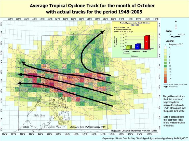
14 Average tropical cyclone tracks 4 th Qtr
15 Annual frequency of T.C. entering the PAR and crossing the Philippines ( ) Annual Number of Tropical Cyclones inside the PAR Crossing and not crossing the Philippines 35 Number of Tropical Cyclones Year TC's which crossed/landfall TC's inside PAR but didn't cross/landfall Annual Average no. entering PAR = 20 Average crossing = 9 T.C.

16 TOTAL DAMAGE DUE TO DISASTROUS TROPICAL CYCLONES ( ) TC YEARS AND NAMES MILENYO 2006 QUEDAN 2005 MARCE 2004 IGME 2004 HARUROT 2003 GILAS 2003 CHEDENG 2003 NANANG 2001 FERIA 2001 REMING 2000 EDENG 2000 ISING 1999 NORMING 1998 LOLENG 1998 ILIANG 1998 GADING 1998 EMANG 1998 ROSING 1995 PEPANG 1995 MAMENG 1995 KATRING 1994 PURING 1993 NANING 1993 MONANG 1993 HUSING 1993 KADIANG 1993 GORING 1993 MARING 1992 LUSING 1992 GLORING 1992 URING 1991 TRINING 1991 RUPING 1990 SALING 1989 GORING 1989 YONING 1988 UNSANG 1988 SISANG 1987 HERMING 1987 SALING 1985 UNDANG 1984 NITANG 1984 BIDANG 1982 ARING 1980 KADING 1978 Original figures not adjusted for inflation BILLION OF PESOS 44 events Top 5 Ruping 1990, Rosing 1995, Loleng 1998, Kadiang 1993, Unsang 1988
17 Mortality due to Tropical Cyclones Tropical Cyclone Names and Year 2004 WINNIE 1998 LOLENG 1995 ROSING 1991 URING 1990 RUPING 1987 SISANG 1984 UNDANG 1984 NITANG 1978 KADING 1970 TITANG 1970 SENING 1952 TRIX 1951 AMY 1949 RENA Mortality 14 events with 300 mortality or more Most number of Mortalities is Tropical storm Uring November 1991 = 5101 deaths Followed by Typhoon Nitang August 1984 = 1029 deaths

18 WHY TRMM IS VALUABLE? The TRMM satellite will provide unique information about the structure and evolution of hurricanes or tropical cyclones. The TRMM satellite carries a Precipitation Radar, the first instrument that can accurately detect and measure rain over land from space.
19

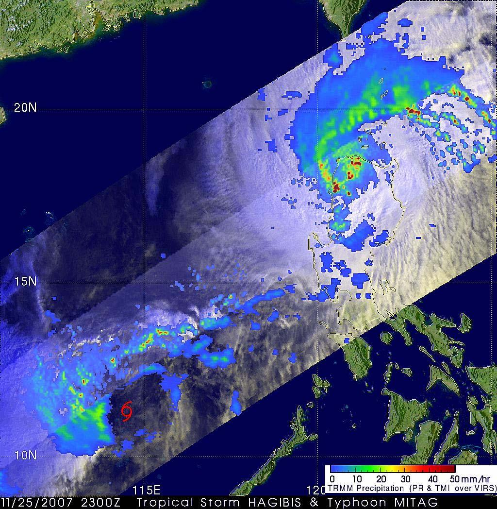
20 TRMM 3-hourly rainfall November 2007 ( TY Lando & Mina)

21 Typhoon MARCE

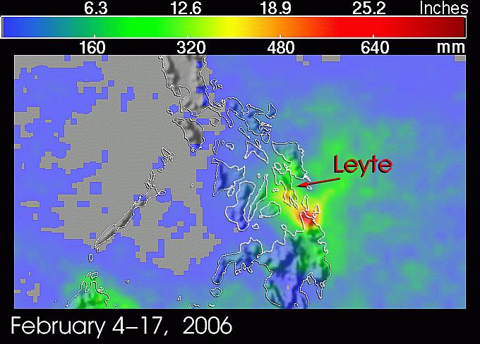
 in the Leyte island southeast region on March 1, 2006 after this disaster.")
22 EXTREME RAINFALL EVENTS The large-scale landslide occurred on February 17 was triggered by the heavy rain. The town of Guinsaugon was buried by the landslide and lost about 1,000 lives. This is the image which was captured by the Advanced Spaceborne Thermal Emission and Reflection Radiometer(ASTER) in the Leyte island southeast region on March 1, 2006 after this disaster. The landslide was about 800m in width and about 3.5km in length.

23 Combined effects of easterly waves and tail end of cold front LANDSLIDE AREA Guinsaugon, Leyte
24 RAINFALL ANALYSIS Tacloban City Guiuan, Eastern Samar Maasin City Otikon Libagon Southern Leyte Hinatuan Daily Daily rainfall accumulation at at Otikon Otikon and five and (5) five (5) nearby stations from February 1 to 28, 2006 nearby stations from February 1 to 28, Surigao del Norte
 677.7 564.7 787 Normal for FEBRUARY 137.0 215.")
25 Daily Rainfall at Selected PAGASA stations February 2006 MAASIN TACLOBAN OTIKON, LIBAGON TOTAL TOTAL (FEB 1-20, 2006) Normal for FEBRUARY % NORMAL (FEB 1-20, 2006)
26
27 Summary/Recommendations TRMM provide accurate estimates of rainfall from tropical cyclones and extreme rainfall events. There are limitations however, particularly on the frequency of data availability. We need more TRMM GPM

 tracking")

28 Voice server-433-ulan (8526) tracking the sky... helping the country
Satellite Data Utilization and Meteorological Hazard Prevention In the Philippines
 Joint Integrated Global Water Cycle Observing(IGWCO)/ Coordinated Enhanced Observing Period (CEOP) Workshop 28 Feb. 4 March 2005, Tokyo, Japan Satellite Data Utilization and Meteorological Hazard Prevention
Validation of COSMO model 24 h forecast rainfall using rain gauges estimated precipitation during occurrence of Typhoon Santi
 African Journal of Agricultural Science and Technology (AJAST) Vol. 3, Issue 6, pp. 286-293. June, 2015 http://www.oceanicjournals.org/ajast ISSN 2311-5882 2015 Oceanic Journals Full Length research Paper
The Philippine National Meteorological & Hydrological Services (NMHS): Its Products, Services and New Initiatives for Sustainable Development
: Its Products, Services and New Initiatives for Sustainable Development") The Philippine National Meteorological & Hydrological Services (NMHS): Its Products, Services and New Initiatives for Sustainable Development A paper presented to the UN-Austria-ESA Symposium on Space
The Philippine National Meteorological & Hydrological Services (NMHS): Its Products, Services and New Initiatives for Sustainable Development A paper presented to the UN-Austria-ESA Symposium on Space
EDNA L. JUANILLO Philippines
 Typhoon GLEnDA [RAMMASUN] EDNA L. JUANILLO Philippines TY GLENDA (RAMMASUN) (July 13-17, 2014) OTHER RELATED INFO It formed as a Tropical Depression (TD) over the Caroline Islands, Pacific Ocean, moving
Introduction. Recent Developments in Observational Network. Analytical tools and Information Delivery system Limitations/Shortcomings
 Introduction Recent Developments in Observational Network Analytical tools and Information Delivery system Limitations/Shortcomings FACILITIES UPGRADING Weather Surveillance Radars Baguio DOST GIA ongoing
REPORT ON SEA LEVEL STATION IN THE PHILIPPINES
 NATIONAL MAPPING AND RESOURCE INFORMATION AUTHORITY HYDROGRAPHY BRANCH REPORT ON SEA LEVEL STATION IN THE PHILIPPINES ENGR. RAUL S. CAPISTRANO PHYSICAL OCEANOGRAPHY DIVISION OCEANOGRAPHIC SURVEY SECTION
An Application of Hydrometeorological Information
 An Application of Hydrometeorological Information Weather-proof Café: Hydro-meteorological information in managing weather risks 17 19 November 2012 National Taiwan University, Chinese Taipei Nikos Viktor
DATE / DAY # REGION BRANCH NAME BANKING SCHEDULE 02 JAN (SAT) 1 North MM Camarin Road - Caloocan 1:00PM - 4:00PM 2 North MM West Triangle 9:00AM -
 1 North MM Camarin Road - Caloocan 1:00PM - 4:00PM 2 North MM West Triangle 9:00AM -") DATE / DAY # REGION BRANCH NAME BANKING SCHEDULE 02 JAN (SAT) 1 North MM Camarin Road - Caloocan 1:00PM - 4:00PM 2 North MM West Triangle 9:00AM - 12:00NN 3 North MM West Avenue 9:00AM - 12:00NN 4 North
DATE / DAY # REGION BRANCH NAME BANKING SCHEDULE 02 JAN (SAT) 1 North MM Camarin Road - Caloocan 1:00PM - 4:00PM 2 North MM West Triangle 9:00AM - 12:00NN 3 North MM West Avenue 9:00AM - 12:00NN 4 North
November 2012 Civil Engineer Licensure Examination
 November 2012 Civil Engineer Licensure Examination The performance of schools in the November 2012 Civil Engineer Licensure Examination in alphabetical order as per R.A. 8981 otherwise known as PRC Modernization
Typhoon Haima (Lawin) Report #3 20 October 2016, 9.00AM PHT. Manila Observatory
 Report #3 20 October 2016, 9.00AM PHT. Manila Observatory") Typhoon Haima (Lawin) Report #3 20 October 2016, 9.00AM PHT Manila Observatory SUMMARY PAGASA reports eye of Super Typhoon Haima (Bagyong Lawin) located at 18.4 N, 120.3 E (as of 7 AM Oct 20) with max
Typhoon Haima (Lawin) Report #3 20 October 2016, 9.00AM PHT Manila Observatory SUMMARY PAGASA reports eye of Super Typhoon Haima (Bagyong Lawin) located at 18.4 N, 120.3 E (as of 7 AM Oct 20) with max
Philippine Natural Hazards, Landforms and Water Forms
 Philippine Natural Hazards, Landforms and Water Forms LEARNING OBJECTIVES: identify the major natural disasters in the country; evaluate the implications of different geographical features and changes
The Weather and Climate Authority
 The Weather and Climate Authority EL NIÑO UPDATE & Climate Outlook (September 2015 February 2016) Prepared by: Climate Monitoring and Prediction Section (CLIMPS) CLIMATOLOGY & AGROMETEOROLOGY DIVISION
TYPHOON HAIYAN. Known as typhoon Yolanda in the Philippines. Most powerful storm to make landfall in recorded history
 TYPHOON HAIYAN Known as typhoon Yolanda in the Philippines Most powerful storm to make landfall in recorded history Worst hit provinces: Leyte and Eastern Samar with a combined population of 2.3 M Experienced
Intense climate disasters and development in asia and the pacific
 Working Draft Ad va n ce Co p Vinod Thomas, Jose Ramon G. Albert, and Rosa T. Perez y Intense climate disasters and development in asia and the pacific Independent Evaluation Intense Climate Disasters
Typhoon Haima (Lawin) Report #4 20 October 2016, 3.00PM PHT. Manila Observatory
 Report #4 20 October 2016, 3.00PM PHT. Manila Observatory") Typhoon Haima (Lawin) Report #4 20 October 2016, 3.00PM PHT Manila Observatory SUMMARY PAGASA reports eye of Super Typhoon Haima (Bagyong Lawin) located at 18.5 N, 119.7 E (as of 10 AM Oct 20) with max
Typhoon Haima (Lawin) Report #4 20 October 2016, 3.00PM PHT Manila Observatory SUMMARY PAGASA reports eye of Super Typhoon Haima (Bagyong Lawin) located at 18.5 N, 119.7 E (as of 10 AM Oct 20) with max
Response and Lesson Learned from Typhoon YOLANDA (HAIYAN)
") 9 th NARBO IWRM Training Tagaytay City May 12-19, 2014 Response and Lesson Learned from Typhoon YOLANDA (HAIYAN) Rene B. Paciente Weather Division, PAGASA Philippines OUTLINE 1. Meteorological Informations
9 th NARBO IWRM Training Tagaytay City May 12-19, 2014 Response and Lesson Learned from Typhoon YOLANDA (HAIYAN) Rene B. Paciente Weather Division, PAGASA Philippines OUTLINE 1. Meteorological Informations
MEMBER REPORT. Philippines
 MEMBER REPORT ESCAP/WMO Typhoon Committee 11th Integrated Workshop Philippines Cebu City, Philippines 24 28 October 2016 CONTENTS I. Overview of tropical cyclones which have affected/impacted Member s
September 2013 R. E. E. Licensure Examination
 September 2013 R. E. E. Licensure Examination The performance of schools in the September 2013 R. E. E. Licensure Examination in alphabetical order as per R.A. 8981 otherwise known as PRC Modernization
What Is This Module About? What Will You Learn From This Module?
 What Is This Module About? Did you know that the Philippines has about 22 typhoons every year? What parts of the country are often visited by typhoons? How much do you know about typhoons? In this module,
Republic of the Philippines PROFESSIONAL REGULATION COMMISSION Manila
 Republic of the Philippines PROFESSIONAL REGULATION COMMISSION Manila CIVIL ENGINEER LICENSURE EXAMINATION RESULTS RELEASED IN THREE (3) WORKING DAYS The Professional Regulation Commission (PRC) announces
Community-Based Flood Early Warning System (CBFEWS)
") Community-Based Flood Early Warning System (CBFEWS) Prepared by: Eng r. Hilario G. Esperanza Eng r.. Socrates F. Paat,, Jr. Flood Forecasting Branch PAGASA Weather Bureau Department of Science and Technology
Community-Based Flood Early Warning System (CBFEWS) Prepared by: Eng r. Hilario G. Esperanza Eng r.. Socrates F. Paat,, Jr. Flood Forecasting Branch PAGASA Weather Bureau Department of Science and Technology
The Role of PAGASA in Disaster Mitigation
 The Role of PAGASA in Disaster Mitigation Christopher F. Perez 2017 ACTS Workshop on Extreme Weather Forecast and Water Resource Management Hanoi, Vietnam September 26-27, 2017 Tropical Storm AMANG(Mekkhala),
TROPICAL CYCLONES. 21 entered the Philippine Area of Responsibility
 08 Highlights of Events Page of 5 TROPICAL CYCLONES SEISMIC ACTIVITIES entered the Philippine Area of Responsibility 8 made landfall 5 Tropical Depression Tropical Storm Category Category 4 Twenty-one
Typhoon Sarika (Karen) Report #2 15 October 2016, 9.00AM PHT. Manila Observatory
 Report #2 15 October 2016, 9.00AM PHT. Manila Observatory") Typhoon Sarika (Karen) Report #2 15 October 2016, 9.00AM PHT Manila Observatory SUMMARY Typhoon Sarika (Bagyong Karen), now upgraded to Cat 1, moving west-northwestward and expected to intensify to Cat
Typhoon Sarika (Karen) Report #2 15 October 2016, 9.00AM PHT Manila Observatory SUMMARY Typhoon Sarika (Bagyong Karen), now upgraded to Cat 1, moving west-northwestward and expected to intensify to Cat
Development of Tropical Storm Falcon (Meari) over the Philippines
 over the Philippines") Development of Tropical Storm Falcon (Meari) over the Philippines June 20-27, 2011 At the end of June, 2011, the Philippines were struck again by Tropical storm Falcon (Meari). After gaining strength over
Development of Tropical Storm Falcon (Meari) over the Philippines June 20-27, 2011 At the end of June, 2011, the Philippines were struck again by Tropical storm Falcon (Meari). After gaining strength over
付属資料付属資料 1 PHIVOLCS 火山モニタリング ネットワーク図付属資料 2 PHIVOLCS 地震 火山観測所リスト付属資料 3 PHIVOLCS 海外研究機関との共同研究プロジェクト リスト付属資料 4 PHIVOLCS 実施中プロジェクト概要付属資料 5
 付属資料付属資料 1 PHIVOLCS 火山モニタリング ネットワーク図付属資料 2 PHIVOLCS 地震 火山観測所リスト付属資料 3 PHIVOLCS 海外研究機関との共同研究プロジェクト リスト付属資料 4 PHIVOLCS 実施中プロジェクト概要付属資料 5 災害情報フローチャート付属資料 6 カウンターパート リスト付属資料 7 協議議事録 付属資料 1 PHIVOLCS 火山モニタリング
Rainfall-Flood Hazard along the Cagayan River in Carmen
 -Flood Hazard along the Cagayan River in Carmen Things to watch out for when rain falls intensity 12 December 2013, Cagayan de Oro City Hall 3 +1 main questions I What do we need to understand about rainfall
PAGASA s Expectations of New-generation Satellites for Hazard Monitoring
 Country Report Philippines PAGASA s Expectations of New-generation Satellites for Hazard Monitoring VICENTE P. PALCON, JR. (Assistant Weather Services Chief) Weather Division- PAGASA DOST Email: vppalconjr@pagasa.dost.gov.ph
AGA2 13 August 1990 COLD WEATHER CLOTHING ALLOWANCE
 115 Republic of the Philippines DEPARMENT OF NATIONAL DEFENSE GENERAL HEADQUARTERS, ARMED FORCES OF THE PHILIPPINES Camp General Emilio Aguinaldo, Quezon City AGA2 13 August 1990 CIRCULAR NUMBER 17 COLD
"STUDY ON THE VARIABILITY OF SOUTHWEST MONSOON RAINFALL AND TROPICAL CYCLONES FOR "
 "STUDY ON THE VARIABILITY OF SOUTHWEST MONSOON RAINFALL AND TROPICAL CYCLONES FOR 2001 2010" ESPERANZA O. CAYANAN, Ph.D. Chief, Climatology & Agrometeorology R & D Section Philippine Atmospheric Geophysical
ASSESSMENT OF SATELLITE PRECIPITATION PRODUCTS IN THE PHILIPPINE ARCHIPELAGO
 ASSESSMENT OF SATELLITE PRECIPITATION PRODUCTS IN THE PHILIPPINE ARCHIPELAGO M. D. Ramos a,b, E. Tendencia b, K. Espana b, J. Sabido b, G. Bagtasa a, a Institute of Environmental Science & Meteorology,
THE PROJECT FOR STUDY ON IMPROVEMENT OF BRIDGES THROUGH DISASTER MITIGATING MEASURES FOR LARGE SCALE EARTHQUAKES IN THE REPUBLIC OF THE PHILIPPINES
 THE REPUBLIC F THE PHILIPPINES DEPARTMENT F PUBLIC WRKS AND HIGHWAYS DPWH) THE PRJECT FR STUDY N IMPRVEMENT F BRIDGES THRUGH DISASTER MITIGATING MEASURES FR LARGE SCALE EARTHQUAKES IN THE REPUBLIC F THE
Polarimetric rainfall retrieval in a tropical environment: consistency analysis for two C-band radars in the Philippines
 Polarimetric rainfall retrieval in a tropical environment: consistency analysis for two C-band radars in the Philippines Irene Crisologo 1, Maik Heistermann 2, and Gianfranco Vulpiani 3 1 University of
Module 11: Meteorology Topic 5 Content: Weather Maps Notes
 Introduction A variety of weather maps are produced by the National Weather Service and National Oceanographic Atmospheric Administration. These maps are used to help meteorologists accurately predict
WORLD METEOROLOGICAL ORGANIZATION. WMO Regional Training Centres (RTCs) Course Offerings for the year Location (City/Country) Term I:
 Course Offerings for the year Location (City/Country) Term I:") RTC/Component: PAGASA RTC, WORLD METEOROLOGICAL ORGANIZATION WMO Regional Training Centres (RTCs) Course Offerings for the year Course Title 1. Meteorologists Training Course Holder of Bachelor s degree
RTC/Component: PAGASA RTC, WORLD METEOROLOGICAL ORGANIZATION WMO Regional Training Centres (RTCs) Course Offerings for the year Course Title 1. Meteorologists Training Course Holder of Bachelor s degree
CAPACITY BUILDING AND DEVELOPMENT OF THE RIC IN MANILA (PHILIPPINES)
") CAPACITY BUILDING AND DEVELOPMENT OF THE RIC IN MANILA (PHILIPPINES) by Ferdinand Y. Barcenas 1 ABSTRACT The Regional Instrument Centre for the South-West Pacific in Manila, Philippines was recognized
CAPACITY BUILDING AND DEVELOPMENT OF THE RIC IN MANILA (PHILIPPINES) by Ferdinand Y. Barcenas 1 ABSTRACT The Regional Instrument Centre for the South-West Pacific in Manila, Philippines was recognized
April 2013 Criminologist Licensure Examination
 April 2013 Criminologist Licensure Examination The performance of schools in the April 2013 Criminologist Licensure Examination in alphabetical order as per R.A. 8981 otherwise known as PRC Modernization
Earth Observation & forecasting Storm Surges in the North Western Pacific. Mr. Nadao Kohno Japan Meteorological Agency
 Earth Observation & forecasting Storm Surges in the North Western Pacific Mr. Nadao Kohno Japan Meteorological Agency Lesson Outline Introduction JMA s responsibility and work as a RSMC, Tokyo Typhoon
2014/2/25. Earth Observation & forecasting Storm Surges in the North Western Pacific. Lesson Outline. RSMC Tokyo Typhoon Center.
 Earth Observation & forecasting Storm Surges in the North Western Pacific Mr. Nadao Kohno Japan Meteorological Agency Lesson Outline Introduction JMA s responsibility and work as a RSMC, Tokyo Typhoon
Republic of the Philippines PROFESSIONAL REGULATION COMMISSION Manila
 Republic of the Philippines PROFESSIONAL REGULATION COMMISSION Manila CERTIFIED PUBLIC ACCOUNTANT LICENSURE EXAMINATION RESULTS RELEASED IN ONE (1) WORKING DAY The Professional Regulation Commission (PRC)
REGIONAL INSTRUMENT CENTER (RIC) MANILA Philippines (Regional Association V)
 MANILA Philippines (Regional Association V)") REGIONAL INSTRUMENT CENTER (RIC) MANILA Philippines (Regional Association V) Ferdinand Barcenas Contact Person, RIC Manila fybarce8@yahoo.com, ferdie@pagasa.dost.gov.ph PAGASA STRUCTURE PAGASA STRUCTURE
REGIONAL INSTRUMENT CENTER (RIC) MANILA Philippines (Regional Association V) Ferdinand Barcenas Contact Person, RIC Manila fybarce8@yahoo.com, ferdie@pagasa.dost.gov.ph PAGASA STRUCTURE PAGASA STRUCTURE
National Report on Weather Forecasting Service
 MINISTRY OF WATER RESOURCES AND METEOROLOGY DEPARTMENT OF METEOROLOGY, CAMBODIA National Report on Weather Forecasting Service Tokyo, 11-15 March 2014 Department of Meteorology, Cambodia Presentation Outline
Presentation Outline. Results of Climate Change. Introductory Information Case Studies. Closing Remarks. Flood zones change
 Presentation Outline Introductory Information Case Studies Romania DESWAT Romania INTEROPERATE The Kingdom of Morocco Weather Radar Network Feasibility Studies Philippines Meteorological and Hydrological
Introduction. Observed Local Trends. Temperature Rainfall Tropical Cyclones. Projections for the Philippines. Temperature Rainfall
 PAGASA-DOST ntroduction Observed Local Trends Temperature Rainfall Tropical Cyclones Projections for the Philippines Temperature Rainfall Climate Change ssue ncreased use of fossil fuel Global Warming
Contribution of Sentinel Asia Activities to Disaster Management in Asia Pacific Region: Sentinel Asia Success Story in the Philippines Project
 Contribution of Sentinel Asia Activities to Disaster Management in Asia Pacific Region: Sentinel Asia Success Story in the Philippines Project Arturo Daag PHIVOLCS, PHILIPPINES 13 October 2015 Bangkok
PROJECT TERMINAL REPORT
 PAGASA PROJECT TERMINAL REPORT Project Title: Program: Assessments of Climate Change Impacts and Mapping of Vulnerability to Food Insecurity under Climate Change to Strengthen Household Food Security with
Tropical Cyclone Warning System in the Philippines
 Republic of the Philippines Department of Science and Technology PHILIPPINE ATMOSPHERIC GEOPHYSICAL AND ASTRONOMICAL SERVICES ADMINISTRAION (PAGASA) Science Garden Compound, Agham Road, Diliman, Quezon
Storm Surge Forecasting and Warning in the Philippines
 Storm Surge Forecasting and Warning in the Philippines 3 rd Masterclass on Disaster Mitigation APAN46 Asia Pacific Advanced Network Meeting 08 August 2018 Jehan Fe S. Panti PAGASA-DOST jspanti@pagasa.dost.gov.ph
Republic of the Philippines
 MEMBER REPORT ESCAP/WMO Typhoon Committee 41 st Session 19-25 January 2009 Chiang Mai, Thailand Republic of the Philippines 1 CONTENTS Page I. Overview of tropical cyclones which have affected/impacted
WMO Statement on the State of the Global Climate Preliminary conclusions for 2018 and WMO Greenhouse Bulletin
 WMO Statement on the State of the Global Climate Preliminary conclusions for 2018 and WMO Greenhouse Bulletin Dr Elena Manaenkova Deputy Secretary General World Meteorological Organisation Statement on
Research on Climate of Typhoons Affecting China
 Research on Climate of Typhoons Affecting China Xu Ming Shanghai Typhoon Institute November,25 Outline 1. Introduction 2. Typhoon disasters in China 3. Climatology and climate change of typhoon affecting
Impact of the 2008 tropical cyclone season on the Baja California Peninsula
 Impact of the 2008 tropical cyclone season on the Baja California Peninsula Centro de Investigación Científica y de Educación Superior de Ensenada (CICESE) Luis M. Farfán Julio August 24, 1830UTC Lowell
Overview of Philippine Geohazards Programs
 Overview of Philippine Geohazards Programs 53 rd CCOP Annual Session CCOP-IUGS Task Group on Geohazards Joint Seminar Cebu City, PHILIPPINES October 18, 2017 Renato U. Solidum, Jr. Department of Science
Japanese Programs on Space and Water Applications
 Japanese Programs on Space and Water Applications Tamotsu IGARASHI Remote Sensing Technology Center of Japan June 2006 COPUOS 2006 Vienna International Centre Water-related hazards/disasters may occur
Heavy Rain/Flooding September 8-10 Associated with Tropical Storm Etau
 Heavy Rain/Flooding September 8-10 Associated with Tropical Storm Etau Wx Files Vol.32 September 24, 2015 Tropical Storm Etau made landfall over the Chita Peninsula in Aichi just after 10:00 AM on September
Progress Report: Sentinel Asia Success Story in the Philippines
 Progress Report: Sentinel Asia Success Story in the Philippines 3 rd Joint Project Team Meeting on the Sentinel Asia STEP-2 July 6-8, 2010 Hyatt Hotel, Manila, Philippines Renato U. Solidum Jr. Director
PROJECT TERMINAL REPORT
 PAGASA PROJECT TERMINAL REPORT Project Title: Assessments of Climate Change Impacts and Mapping of Vulnerability to Food Insecurity under Climate Change to Strengthen Household Food Security with Livelihoods
EFFECTIVE TROPICAL CYCLONE WARNING IN BANGLADESH
 Country Report of Bangladesh On EFFECTIVE TROPICAL CYCLONE WARNING IN BANGLADESH Presented At JMA/WMO WORKSHOP ON EFFECTIVE TROPICAL CYCLONE WARNING IN SOUTHEAST ASIA Tokyo, Japan,11-14 March 2014 By Sayeed
Climate Trends and projected. Climate Change in the Philippines. Observed PAGASA. Presented by: Thelma A. Cinco Assistant Weather Services Chief
 Observed Climate Trends and projected Climate Change in the Philippines Presented by: Thelma A. Cinco Assistant Weather Services Chief Philippine Atmospheric, Geophysical and Astronomical Services Administration
Philippines: Pearl of the Orient Seas
 Chapter Philippines: Pearl of the Orient Seas The second-largest archipelago in the world, with over 7000 tropical islands, the Philippines is one of the great treasures of Southeast Asia. Often overlooked
Why There Is Weather?
 Lecture 6: Weather, Music Of Our Sphere Weather and Climate WEATHER The daily fluctuations in atmospheric conditions. The atmosphere on its own can produce weather. (From Understanding Weather & Climate)
Activities and Outlook related to Disaster Reduction in CMA
 Activities and Outlook related to Disaster Reduction in CMA WANG Bangzhong China Meteorological Administration March 15-17 2006 ADENDA Situation about MD and related disasters in CHINA Guidance for MD/RD
Spatial Analysis of Income Growth in the Philippines: Evidence from Intra-Country Data (1988 to 2009)
") MPRA Munich Personal RePEc Archive Spatial Analysis of Income Growth in the Philippines: Evidence from Intra-Country Data (1988 to 2009) Dennis Mapa and Manuel Leonard Albis and Dorcas Mae Comandante and
MPRA Munich Personal RePEc Archive Spatial Analysis of Income Growth in the Philippines: Evidence from Intra-Country Data (1988 to 2009) Dennis Mapa and Manuel Leonard Albis and Dorcas Mae Comandante and
Republic of the Philippines PROFESSIONAL REGULATION COMMISSION Manila
 Republic of the Philippines PROFESSIONAL REGULATION COMMISSION Manila CERTIFIED PUBLIC ACCOUNTANT LICENSURE EXAMINATION RESULTS RELEASED IN ONE (1) WORKING DAY The Professional Regulation Commission (PRC)
Improvement of Hazard Assessment and Management in the Philippines
 Improvement of Hazard Assessment and Management in the Philippines (2014 Summer Training Course for Slope Land Disaster Reduction) Ian Alejandrino (Philippines) Nguyen Manh Hieu (Vietnam) Presentation
MEMBER REPORT (Singapore)
") MEMBER REPORT (Singapore) ESCAP/WMO Typhoon Committee 12th Integrated Workshop Jeju, Republic of Korea 30 October 3 November 2017 CONTENTS I. Overview of tropical cyclones which have affected/impacted
MEMBER REPORT (Singapore) ESCAP/WMO Typhoon Committee 12th Integrated Workshop Jeju, Republic of Korea 30 October 3 November 2017 CONTENTS I. Overview of tropical cyclones which have affected/impacted
Climate of the Philippines and the sea surface temperature effect on summer monsoon rainfall in the Philippines
 International Workshop on Climate Downscaling Studies at Tsukuba, October 4, 2017 Climate of the Philippines and the sea surface temperature effect on summer monsoon rainfall in the Philippines Jun Matsumoto
9. Case study on disaster events using radar data
 9. Case study on disaster events using radar data 9 February 2018 Masahito ISHIHARA Former Meteorologist/Researcher of Japan Meteorological Agency Former Professor of Kyoto University 9. Case study on
Nested coupled air/sea modeling for multi-scale processes in the Maritime Continent
 Nested coupled air/sea modeling for multi-scale processes in the Maritime Continent Julie Pullen Stevens Institute of Technology Arnold Gordon Columbia University Maria Flatau & James Doyle Naval Research
DRRM in the Philippines: DRRM Projects, Geoportals and Socio-Economic Integration
 Regional workshop on Geo-referenced information system for improving disaster risk preparedness and management in Asia and the Pacific 26-27 June 2014, UNCC, Bangkok, Thailand DRRM in the Philippines:
RAINFALL DURATION-FREQUENCY CURVE FOR UNGAGED SITES IN THE HIGH RAINFALL, BENGUET MOUNTAIN REGION IN THE PHILIPPINES
 RAINFALL DURATION-FREQUENCY CURVE FOR UNGAGED SITES IN THE HIGH RAINFALL, BENGUET MOUNTAIN REGION IN THE PHILIPPINES GUILLERMO Q. TABIOS III Department of Civil Engineering, University of the Philippines
APPENDIX 2 OVERVIEW OF THE GLOBAL PRECIPITATION MEASUREMENT (GPM) AND THE TROPICAL RAINFALL MEASURING MISSION (TRMM) 2-1
 AND THE TROPICAL RAINFALL MEASURING MISSION (TRMM) 2-1") APPENDIX 2 OVERVIEW OF THE GLOBAL PRECIPITATION MEASUREMENT (GPM) AND THE TROPICAL RAINFALL MEASURING MISSION (TRMM) 2-1 1. Introduction Precipitation is one of most important environmental parameters.
APPENDIX 2 OVERVIEW OF THE GLOBAL PRECIPITATION MEASUREMENT (GPM) AND THE TROPICAL RAINFALL MEASURING MISSION (TRMM) 2-1 1. Introduction Precipitation is one of most important environmental parameters.
CLIMATE SERVICES for the AGRICUTURAL SECTOR in the PHILIPPINES
 CLIMATE SERVICES for the AGRICUTURAL SECTOR in the PHILIPPINES EDNA L. JUANILLO Weather Services Chief, PAGASA Technical Conference on Future Challenges and Opportunities in Agricultural Meteorology 16-17
A Questionnaire on the Utilization of Satellite Data from the New Generation of Geostationary Meteorological Satellites
 3.1 User requirements for satellite data utilization, especially for new-generation satellites A Questionnaire on the Utilization of Satellite Data from the New Generation of Geostationary Meteorological
Lecture 4b: Meteorological Satellites and Instruments. Acknowledgement: Dr. S. Kidder at Colorado State Univ.
 Lecture 4b: Meteorological Satellites and Instruments Acknowledgement: Dr. S. Kidder at Colorado State Univ. US Geostationary satellites - GOES (Geostationary Operational Environmental Satellites) US
March 2013 Licensure Examination for Teachers
 March 2013 Licensure Examination for Teachers The performance of schools in the March 2013 Licensure Examination for Teachers is presented below in alphabetical order as per R.A. 8981 otherwise known as
Cebu & Bohol Road Map (Philippines) READ ONLINE
 READ ONLINE") Cebu & Bohol Road Map (Philippines) READ ONLINE If looking for the book Cebu & Bohol Road Map (Philippines) in pdf format, then you have come on to faithful website. We furnish utter variant of this book
Cebu & Bohol Road Map (Philippines) READ ONLINE If looking for the book Cebu & Bohol Road Map (Philippines) in pdf format, then you have come on to faithful website. We furnish utter variant of this book
CHALLENGES ON SEDIMENT- RELATED DISASTER MITIGATION
 CHALLENGES ON SEDIMENT- RELATED DISASTER MITIGATION Dolores M. Hipolito Project Manager II DPWH, PMO-FCSEC Types of Sediment-Related Disasters A. Direct Disaster Debris flows Landslides Slope failures
Application of Satellite Data for Flood Forecasting and Early Warning in the Mekong River Basin in South-east Asia
 MEKONG RIVER COMMISSION Vientiane, Lao PDR Application of Satellite Data for Flood Forecasting and Early Warning in the Mekong River Basin in South-east Asia 4 th World Water Forum March 2006 Mexico City,
8/26/2011. Natural Hazards
 Support to Local Governments to Imrpove Environmental Management in Southeast Asia August, 011 CSB Hotel, Angelo King International Center, Manila The National Geohazards Mapping and Assessment Program
US/Global Natural Catastrophe Update
 US/Global Natural Catastrophe Update NAIC's CIPR Symposium on Implications of Increasing Catastrophe Volatility on Insurers Carl Hedde, SVP, Head of Risk Accumulation Munich Reinsurance America, Inc. Source:
Verification of the Seasonal Forecast for the 2005/06 Winter
 Verification of the Seasonal Forecast for the 2005/06 Winter Shingo Yamada Tokyo Climate Center Japan Meteorological Agency 2006/11/02 7 th Joint Meeting on EAWM Contents 1. Verification of the Seasonal
Unit 5 Lesson 3 How is Weather Predicted? Copyright Houghton Mifflin Harcourt Publishing Company
 Tracking the Weather Warm up 1 Why is it important to watch the weather forecast before traveling to another country? Tracking the Weather A meteorologist is a scientist who studies weather. Meteorologists
ATMOSPHERIC MODELLING. GEOG/ENST 3331 Lecture 9 Ahrens: Chapter 13; A&B: Chapters 12 and 13
 ATMOSPHERIC MODELLING GEOG/ENST 3331 Lecture 9 Ahrens: Chapter 13; A&B: Chapters 12 and 13 Agenda for February 3 Assignment 3: Due on Friday Lecture Outline Numerical modelling Long-range forecasts Oscillations
Remote Sensing-based Flood Mapping and Flood Hazard Assessment in Haiti
 www.dartmouth.edu/~floods/ csdms.colorado.edu Remote Sensing-based Flood Mapping and Flood Hazard Assessment in Haiti Rebuilding for Resilience: How Science and Engineering Can Inform Haiti's Reconstruction,
WEATHER AND CLIMATE EXTREMES MONITORING BASED ON SATELLITE OBSERVATION : INDONESIA PERSPECTIVE RIRIS ADRIYANTO
 WEATHER AND CLIMATE EXTREMES MONITORING BASED ON SATELLITE OBSERVATION : INDONESIA PERSPECTIVE RIRIS ADRIYANTO INDONESIA AGENCY FOR METEOROLOGY, CLIMATOLOGY AND GEOPHYSICS (BM KG) 1. INTRODUCTION - BMKG
Recent development of the National Hydro-Meteorological Service (NHMS) of Viet Nam for disaster risk reduction
 of Viet Nam for disaster risk reduction") Ministry of Natural Resources and Environment National Hydro-Meteorological Service Recent development of the National Hydro-Meteorological Service (NHMS) of Viet Nam for disaster risk reduction Tran Van
Ministry of Natural Resources and Environment National Hydro-Meteorological Service Recent development of the National Hydro-Meteorological Service (NHMS) of Viet Nam for disaster risk reduction Tran Van
MODELLING FROST RISK IN APPLE TREE, IRAN. Mohammad Rahimi
 WMO Regional Seminar on strategic Capacity Development of National Meteorological and Hydrological Services in RA II (Opportunity and Challenges in 21th century) Tashkent, Uzbekistan, 3-4 December 2008
New Concept of Regional Cooperation in Asia for Water Disaster Management Applying Satellite Precipitation Measurement
 New Concept of Regional Cooperation in Asia for Water Disaster Management Applying Satellite Precipitation Measurement Yusuke Muraki Japan Aerospace Exploration Agency (JAXA) Mission Planning Department
From disaster to climate science to national planning: Learning from Haiyan.
 From disaster to climate science to national planning: Learning from Haiyan. Thelma A. Cinco Assistant Weather Services Chief, CAD, Philippine Atmospheric, Geophysical and Astronomical Services Administration
Welcome and Introduction
 Welcome and Introduction Riko Oki Earth Observation Research Center (EORC) Japan Aerospace Exploration Agency (JAXA) 7th Workshop of International Precipitation Working Group 17 November 2014 Tsukuba International
PAMPANGA RIVER BASIN Flood Events 1. Tropical Storm Ondoy, September 25 to 27, Typhoon Pepeng, October 6 to 15, 2009
 Pampanga River Basin Flood Forecasting & Warning Center HMD, PAGASA DOST Region 3 Compound, San Fernando, Pampanga Website: www.prffwc.webs.com PRFFWC Post-Flood Report 29-1 (Rev. Nov. 3, 29) PAMPANGA
Ch. 11: Hurricanes. Be able to. Define what hurricane is. Identify the life and death of a hurricane. Identify the ways we track hurricanes.
 Ch. 11: Hurricanes Be able to Define what hurricane is. Identify the life and death of a hurricane. Identify the ways we track hurricanes. What are Hurricanes? Smaller than mid-latitude cyclones. Don t
Page 1. Name: 4) State the actual air pressure, in millibars, shown at Miami, Florida on the given weather map.
 State the actual air pressure, in millibars, shown at Miami, Florida on the given weather map.") Name: Questions 1 and 2 refer to the following: A partial station model and meteorological conditions table, as reported by the weather bureau in the city of Oswego, New York, are shown below. 1) Using
Name: Questions 1 and 2 refer to the following: A partial station model and meteorological conditions table, as reported by the weather bureau in the city of Oswego, New York, are shown below. 1) Using
Impact of Intraseasonal Variations to the Spatial Distribution of Coastal Heavy Rainbands Intensity During HARIMAU IOP 2011 in the West Sumatera
 Impact of Intraseasonal Variations to the Spatial Distribution of Coastal Heavy Rainbands Intensity During HARIMAU IOP 2011 in the West Sumatera Ardhi Adhary Arbain, Yekti Galihselowati Agency for the
LECTURE #15: Thunderstorms & Lightning Hazards
 GEOL 0820 Ramsey Natural Disasters Spring, 2018 LECTURE #15: Thunderstorms & Lightning Hazards Date: 1 March 2018 (lecturer: Dr. Shawn Wright) I. Severe Weather Hazards focus for next few weeks o somewhat
Juban is faced with several major, major,major,major, major Natural Disasters and Hazards..
 Juban Hazards Juban Disaster Risk Reduction and Management Council (JMDRRMC) Juban Hazard Profile Juban is faced with natural multigeohazards / disasters. >>> Typhoons / Floods Bicol Region typhoon belt
UPDATE OF REGIONAL WEATHER AND SMOKE HAZE (December 2017)
") UPDATE OF REGIONAL WEATHER AND SMOKE HAZE (December 2017) 1. Review of Regional Weather Conditions for November 2017 1.1 In November 2017, Southeast Asia experienced inter-monsoon conditions in the first
UPDATE OF REGIONAL WEATHER AND SMOKE HAZE (December 2017) 1. Review of Regional Weather Conditions for November 2017 1.1 In November 2017, Southeast Asia experienced inter-monsoon conditions in the first
Overview of existing Weather Forecasting and Warning infrastructures in Myanmar
 Overview of existing Weather Forecasting and Warning infrastructures in Myanmar by Dr. Zin Mie Mie Sein Officer (DMH) 26. February. 2018 Nay Pyi Taw Outline Introduction Myanmar & its disasters Meteorological
New NASA Ocean Observations and Coastal Applications
 New NASA Ocean Observations and Coastal Applications Duane Armstrong Chief, Applied Science & Technology Project Office August 20, 2014 1 Outline NASA s new Earth Science Ocean Science Missions for 2014