Presentation Outline. Results of Climate Change. Introductory Information Case Studies. Closing Remarks. Flood zones change
|
|
|
- Gwendoline Powell
- 5 years ago
- Views:
Transcription


1 Presentation Outline Introductory Information Case Studies Romania DESWAT Romania INTEROPERATE The Kingdom of Morocco Weather Radar Network Feasibility Studies Philippines Meteorological and Hydrological Telecommunications Upgrade Closing Remarks Results of Climate Change Flood zones change Flooding and droughts become less predictable Design standards are no longer adequate We loose the understanding of weather and storm water related dynamics


2 Developing Countries Ability to accurately predict weather does not always exist The US Trade & Development Agency (TDA) is funding Feasibility Studies to improve weather related facilities B&N managed four weather related international projects two in Romania, Morocco, and the Philippines. USTDA Mission: Advance economic development in developing and middle income countries Fund projects that support development of modern infrastructure and fair trade Stimulate American business Weather Related Activities Forecasting 6 hours to 10 days Now Casting 0 to 6 hours Real-time

 Clouds Rain Hail")

3 Forecasting Upper air soundings Satellite Computer models Now Casting Doppler Radar Useful for observation of precipitation (measures freq. differences of microwave signals) Clouds Rain Hail Snow Real Time Data Precipitation Temperature Humidity Barometric pressure Wind speed & direction Stream flow Soil moisture
4 Weather Related Data Provides Advanced warning of dangerous storm events Flood and droughts become more predictable Used to establish design standards Land use planning Design of flood control structures Title Goes Here Bullets Go Here And Here Case Study: Romania DESWAT Case Study: Romania Destructive Waters (DESWAT) Feasibility Study Evaluation, Selection and Testing Process for Hydrologic and Hydraulic Flood Models for Use in Romania
 Mapping Needs For Hydrologic modeling 1:50,000 For Hydraulic modeling 1:10,000 New mapping could be used for many purposes in addition to flood modeling")
5 Romania Model Review Process Eight models reviewed in US workshops Four models selected for consideration Vflo (Vieux Associates) RiverTrak (Riverside Technologies) River Forecast System (USNWS) Corps Water Management System (USCOE) Mapping Needs For Hydrologic modeling 1:50,000 For Hydraulic modeling 1:10,000 New mapping could be used for many purposes in addition to flood modeling Satellite mapping may be considered

6 Recommended Model Group Vflo for small basins to 200 KM2 RiverTrak for larger basins 200-5,000 KM2 RFS model basins over 5,000 KM2 Vidra model- basins over 500 KM2, as an interim approach, in parallel with Vflo and RiverTrak models Lapus Basin Pilot Demonstration Application of Vflo and Vidra models Vflo training in January 2003 Attended by 19 staff trainees Application included May 1970 storm Examples of input and resulting inundation maps Hourly Gauge Distribution Rainfall Hyetograph at Baia Mare and Lezer Gauges May 1970


7 Storm Total Rainfall Resulting Map of Storm Total Accumulations May 1970 Discharge at Lapusel Gauge Station Vflo: Discharge at Lapusel Gage May 1970 Flood Inundation Lapus Basin Modeled Flood Inundation in the Lapus Basin May 1970 Event
8 Vidra Application To Lapus Basin Application of May 1970 storm Examples of hydrographs and resulting inundation maps Flood Wave Hydrographs Vidra: Flood Wave Hydrographs Recorded at the Gauging Stations from the Lapus River Basin in May 1970 Q(m 3 /s) h h Lapus R.- Lapusel St. Lapus R.- Razoare St. Cavnic R.- Copalnic St. Sasar R.-Baia Mare St. Suciu R.- Suciu St Time(hour) Stations Razore and Lapusel Computed and Recorded Hydrographs at the Razore and Lapusel Stations in May 1970 Comparison Lapusel Station 1970 Comparison Razoare Station 1970 Q(m 3 /s) Computed Q(m 3 /s) Computed Recorded 600 Recorded Time(hours) Time(hours)
 Feasibility Study Conclusions Newer data available from radar makes faster")

9 Modeled Flood Inundation Modeled Flood Induation in the Lapus Basin May 1970 (Bozanta Mare & Bozanta Mica) Modeled Flood Inundation Modeled Flood Inundation in the Lapus Basin May 1970 (Sacalaseni Area) Feasibility Study Conclusions Newer data available from radar makes faster modeling feasible Available models can make use of this data to rapidly model flood conditions and speed the warning and preparation process The Vflo, RiverTrak and NWS models are well suited to this upgrade The Vidra model should be continued as an interim approach on larger basins
10 Project Update Seven of the 11 basins are operational Lockheed Martin won the implementation $64 million of US equipment and services export A USTDA success story Title Goes Here Bullets Go Here And Here Case Study: Romania INTEROPERATE Case Study: Romania Case Study: Romania Integrated Climatology, Agro-meteorological, Air Pollution Forecast and Warning, Computation and Training Center (INTEROPERATE) Feasibility Study
 Radar national coverage in")
11 Primary Project Goals Assess existing integrated system for meteorological surveillance, forecast, and alert system in Romania Analyze proposed enhancements to the forecast and alert systems Primary Project Goals General improvement of the forecasts, especially for severe weather events More accurate characterization of weather events (both in lead time and magnitude) Radar national coverage in Romania Needs Assessment Current Capabilities Computation Requirements Data Storage Requirements Operational Requirements
12 Current Capabilities Sun E4500 w/8 processors Generic Linux cluster of 28 processors 1.2 Terrabytes online Offline storage is varied Need hierarchical storage management system Computation Requirements MM5, WRF, ALADIN, LM, AROME All require a system with high memory bandwidth between processor and main memory Data Storage Requirements Computing data and imaging data must be stored (operational and archival) Desire 30 days of operational data Archival data may be permanent


13 Operational Requirements Redundancy and fault tolerance are critical elements of the system requirements During periods of critical threats or system faults, research applications will be interruptible in favor of operations INTEROPERATE RNMA Existing Data Storage Pools INTEROPERATE Typical Compute Node Configurations Note: A system achieving equivalent performance with a configuration different from the above would be equally satisfactory

14 INTEROPERATE Typical Service Node Configurations Note: A system achieving equivalent performance with a configuration different from the above would be equally satisfactory Training Needs Assessment Infuse developing science and technology into existing operations Maintain level of expertise current with national and international research Enhance and stimulate staff learning Assure effective use of existing and new equipment IT Training Program Categories Supercomputer for operators, administration, users and maintenance Databases for database and OS administrators, users and operators
15 Meteorology Training Program Categories Climate Variability Convective Weather Note - * indicates existing Emergency Management training program Hydrology/Flooding Mesoscale Meteorology* NWP (Modeling) Quantitative Precipitation Forecasting (QPF) Radar Meteorology and Nowcasting* Satellite Meteorology* Winter Weather Agro-Meteorology Modeling* Air Pollution Meteorology* INTEROPERATE Planned processes and products (very high resolution models 2 to 3 km grids) AROME Mesoscale model, non-hydrostatic with km grid using 300 to 600 x the comp ability of ALADIN now COSMO Project (Local Model - LM) - Tested at 2.8 & 7 km grid on generic LINUX cluster WRF A non-hydrostatic mesoscale US model which is an improvement on the MM5 model of PSU Project Update Computer building constructed International tender (RFP) on hold for super computer pending Romanian government funding

16 Title Goes Here Bullets Go Here And Here Case Study: Morocco Weather Radar Network Feasibility Study Mission: Establish an effective national system for forecasting environmental crises to guarantee security and stability Goal: Improve quality of life and promote economic development


17 General Statistics Moroccan GNP $85.2 billion Population 34,436,000 GNP per capita $2,474 Area 446,300 Sq. Km Typical Rainfall varies 50 to 800 mm per year Average Temperature 17 to 19 C Temperature range -7 to 25 C Normal Annual Rainfall Mohammadia 2002


18 Oujda 2008 Nador 2008 b6 Damage Caused by Flooding
19 Slide 54 b6 Fix so the legend can be seen by audience bouman, 8/30/2009
20 Estimated Losses Since the Mid 1990s Loss Description USD Percent of Total Human Loss 20,168, % Peopled touched 631, % Employment 1,479, % Industrial 66,726, % Agricultural 38,566, % Housing 22,648, % Public/Private property 15,641, % Road infrastructure 1,713, % Total 167,572, % b7 Existing Radar Coverage Larache Casablanca Fes Khouribga Bengrir Agadir Deficiencies of Existing Radar Sites Excessive overlap between radars at Casablanca, Khouribga Radars at Fez and Agadir have poor coverage due to interferences of the Atlas Mountains
21 Slide 56 b7 Pat let's discuss the dynamics of this slide bouman, 8/30/2009

22 b12 b13 Radar Coverage Radar Site Analysis b14 b15 Radar Coverage
23 Slide 58 b12 b13 Pat let's discuss the dynamics of this slide bouman, 8/30/2009 Have the new radars fly in sperately bouman, 8/30/2009 Slide 60 b14 b15 Pat let's discuss the dynamics of this slide bouman, 8/30/2009 Have the new radars fly in sperately bouman, 8/30/2009
24 Radar Citing Criteria 1. Improve public safety 2. Decrease economic loss to urban industry and agriculture 3. Improve forecasts 4. Improve aviation safety 5. Aide specific projects (hail suppression and snow enhancement) Conclusions for Morocco Areas between coast lines and the Atlas mountains are covered well by radar Existing radar systems have black spots that limit forecasting impact weather and flood forecasting capabilities No radar sites east of the Atlas Mountains New radar locations are being recommended Title Goes Here Bullets Go Here And Here Case Study: Philippines
25 Case Study Philippines Meteorological and Hydrological Telecommunications Upgrade General Stats of the Philippines Population 88 million Area 298,170 Sq. Km (slightly larger than (AZ) GNP $108 billion GNP per capita $1,300 Typical Rainfall 965 to 4,064 mm Average Temperature Range 25 to 29 C Project Objectives Recommend a reliable and redundant telecommunications system Implementation plan to transmit data to the main and regional centers


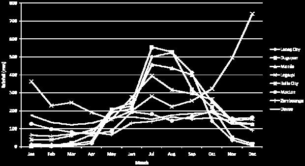
26 The Philippines b9 Satellite Images b16 Rainfall Data
27 Slide 68 b9 Fix heading to be consistent to other slides bouman, 8/30/2009 Slide 69 b16 Need to find a map of rainfall distribution... talk to Mark Hegglli bouman, 8/30/2009


28 Photos of Damages Existing and Proposed Radars
29 proposed new repeater North Backbone Apa Tug Aparri Radar Tuguegarao Ilagan Cauayan Baguio Radar Magat Carmen Rosales Yanbong Yan Cau Tarlac Mt. Ampucao Cabanatuan Gapan PAGASA DIC San Rafael existing repeater PAGASA Science Garden South Backbone Science Garden Polilio Baler Radar Tagaytay Lucban PAGASA - DIC Pili Atimonan Sipocot Gapas Bulan Malabog Virac Radar Tugas Legaspi Danao Cagayan de Oro Tac-Dan-Gui Dan-Mal Guiuan Radar Mactan Radar Malasag Legend: proposed new repeater existing repeater The Challenge Existing and proposed radars provide adequate coverage Existing backbone uses 800 MHz The NTC (Philippines FCC) sold the frequency (licensed Spectrum) and it is being used by cellular companies Backbone communications not functional due to interferences
30 Title Goes Here Bullets Go Here And Here Summary Conclusions of Presentation Many developing and middle income countries do not have adequate weather forecasting tools Forecasting tools provide an understanding of storm dynamics and impacts Knowledge is empowering saves lives and protects built environment Conclusions of Presentation Funding is available from USTDA for feasibility studies Other funding programs are available for implementation (USAID, World Bank, multi national banks, etc.) US engineering firms and public/private partners offer advanced technology and expertise of weather management systems
31 Conclusions of Presentation Weather management expertise includes Forecasting systems Now casting radar Real time data Communication systems Data management Modeling and warnings Land use planning and development Title Goes Here Bullets Go Here And Here Your Questions? Thank You!
Regional Flash Flood Guidance and Early Warning System
 WMO Training for Trainers Workshop on Integrated approach to flash flood and flood risk management 24-28 October 2010 Kathmandu, Nepal Regional Flash Flood Guidance and Early Warning System Dr. W. E. Grabs
Satellite Data Utilization and Meteorological Hazard Prevention In the Philippines
 Joint Integrated Global Water Cycle Observing(IGWCO)/ Coordinated Enhanced Observing Period (CEOP) Workshop 28 Feb. 4 March 2005, Tokyo, Japan Satellite Data Utilization and Meteorological Hazard Prevention
Emerging Needs, Challenges and Response Strategy
 Emerging Needs, Challenges and Response Strategy Development of Integrated Observing Systems in China JIAO Meiyan Deputy Administrator China Meteorological Administration September 2011 Geneva Outline
CLIMATE CHANGE ADAPTATION BY MEANS OF PUBLIC PRIVATE PARTNERSHIP TO ESTABLISH EARLY WARNING SYSTEM
 CLIMATE CHANGE ADAPTATION BY MEANS OF PUBLIC PRIVATE PARTNERSHIP TO ESTABLISH EARLY WARNING SYSTEM By: Dr Mamadou Lamine BAH, National Director Direction Nationale de la Meteorologie (DNM), Guinea President,
Introduction. Recent Developments in Observational Network. Analytical tools and Information Delivery system Limitations/Shortcomings
 Introduction Recent Developments in Observational Network Analytical tools and Information Delivery system Limitations/Shortcomings FACILITIES UPGRADING Weather Surveillance Radars Baguio DOST GIA ongoing
Flash Flood Guidance System On-going Enhancements
 Flash Flood Guidance System On-going Enhancements Hydrologic Research Center, USA Technical Developer SAOFFG Steering Committee Meeting 1 10-12 July 2017 Jakarta, INDONESIA Theresa M. Modrick Hansen, PhD
Recent development of the National Hydro-Meteorological Service (NHMS) of Viet Nam for disaster risk reduction
 of Viet Nam for disaster risk reduction") Ministry of Natural Resources and Environment National Hydro-Meteorological Service Recent development of the National Hydro-Meteorological Service (NHMS) of Viet Nam for disaster risk reduction Tran Van
Ministry of Natural Resources and Environment National Hydro-Meteorological Service Recent development of the National Hydro-Meteorological Service (NHMS) of Viet Nam for disaster risk reduction Tran Van
National Weather Service Flood Forecast Needs: Improved Rainfall Estimates
 National Weather Service Flood Forecast Needs: Improved Rainfall Estimates Weather Forecast Offices Cleveland and Northern Indiana Ohio River Forecast Center Presenter: Sarah Jamison, Service Hydrologist
United States Multi-Hazard Early Warning System
 United States Multi-Hazard Early Warning System Saving Lives Through Partnership Lynn Maximuk National Weather Service Director, Central Region Kansas City, Missouri America s s Weather Enterprise: Protecting
Application of Satellite Data for Flood Forecasting and Early Warning in the Mekong River Basin in South-east Asia
 MEKONG RIVER COMMISSION Vientiane, Lao PDR Application of Satellite Data for Flood Forecasting and Early Warning in the Mekong River Basin in South-east Asia 4 th World Water Forum March 2006 Mexico City,
Complete Weather Intelligence for Public Safety from DTN
 Complete Weather Intelligence for Public Safety from DTN September 2017 White Paper www.dtn.com / 1.800.610.0777 From flooding to tornados to severe winter storms, the threats to public safety from weather-related
Validation of COSMO model 24 h forecast rainfall using rain gauges estimated precipitation during occurrence of Typhoon Santi
 African Journal of Agricultural Science and Technology (AJAST) Vol. 3, Issue 6, pp. 286-293. June, 2015 http://www.oceanicjournals.org/ajast ISSN 2311-5882 2015 Oceanic Journals Full Length research Paper
FFGS Advances. Initial planning meeting, Nay Pyi Taw, Myanmar February, Eylon Shamir, Ph.D,
 FFGS Advances Initial planning meeting, Nay Pyi Taw, Myanmar 26-28 February, 2018 Eylon Shamir, Ph.D, EShamir@hrcwater.org Hydrologic Research Center San Diego, California FFG System Enhancements The following
The current status, functions, challenges and needs of South Sudan Meteorological Department (SSMD)
") The current status, functions, challenges and needs of South Sudan Meteorological Department (SSMD) Presented: by Mojwok Ogawi Modo, South Sudan Meteorological Department. Background The present SSMD was
The current status, functions, challenges and needs of South Sudan Meteorological Department (SSMD) Presented: by Mojwok Ogawi Modo, South Sudan Meteorological Department. Background The present SSMD was
REQUIREMENTS FOR WEATHER RADAR DATA. Review of the current and likely future hydrological requirements for Weather Radar data
 WORLD METEOROLOGICAL ORGANIZATION COMMISSION FOR BASIC SYSTEMS OPEN PROGRAMME AREA GROUP ON INTEGRATED OBSERVING SYSTEMS WORKSHOP ON RADAR DATA EXCHANGE EXETER, UK, 24-26 APRIL 2013 CBS/OPAG-IOS/WxR_EXCHANGE/2.3
Global Flash Flood Guidance System Status and Outlook
 Global Flash Flood Guidance System Status and Outlook HYDROLOGIC RESEARCH CENTER San Diego, CA 92130 http://www.hrcwater.org Initial Planning Meeting on the WMO HydroSOS, Entebbe, Uganda 26-28 September
Moroccan lightning detection network, topology, performance and management of the network
 Moroccan lightning detection network, topology, performance and management of the network Mohamed DAHOUI, Mohamed NBOU and Rabia MERROUCHI Moroccan Meteorological Center Tel (212)71302837, Fax: (212)22908593
JICA s Cooperation for NMHSs. Taisuke Watanabe Japan International Cooperation Agency
 JICA s Cooperation for NMHSs Taisuke Watanabe 28 Oct, 2014 JICA s Assistant Approach for Hydrological and Meteorological Services Assistance for improvement of Hydrological and Meteorological Services
Integrating Nowcastingwith crisis management and risk prevention in a transnational framework (INCA-CE)
") Integrating Nowcastingwith crisis management and risk prevention in a transnational framework (INCA-CE) Yong Wang ZAMG, Austria This project is implemented through the CENTRAL EUROPE Programme co-financed
Integrating Nowcastingwith crisis management and risk prevention in a transnational framework (INCA-CE) Yong Wang ZAMG, Austria This project is implemented through the CENTRAL EUROPE Programme co-financed
Weather Forecasting. March 26, 2009
 Weather Forecasting Chapter 13 March 26, 2009 Forecasting The process of inferring weather from a blend of data, understanding, climatology, and solutions of the governing equations Requires an analysis
CASA WX DFW URBAN DEMONSTRATION NETWORK
 CASA WX DFW URBAN DEMONSTRATION NETWORK Goals Background on Regional CASA WX Project Explain the capabilities, structure of the Radar Network Present the CASA WX DFW Test Bed will be rolled out Describe
Landslide monitoring system in Iceland. Harpa Grímsdóttir Jón Kristinn Helgason NVE, Oslo, October
 Landslide monitoring system in Iceland Harpa Grímsdóttir Jón Kristinn Helgason NVE, Oslo, October 26 2016 History Avalanches and landslides have caused extensive damages and loss of human lives in Iceland
New Concept of Regional Cooperation in Asia for Water Disaster Management Applying Satellite Precipitation Measurement
 New Concept of Regional Cooperation in Asia for Water Disaster Management Applying Satellite Precipitation Measurement Yusuke Muraki Japan Aerospace Exploration Agency (JAXA) Mission Planning Department
The importance of satellite data and products for RA1 in the WWRP strategy. Estelle de Coning World Weather Research Division
 The importance of satellite data and products for RA1 in the WWRP strategy Estelle de Coning World Weather Research Division Kofi Annan former UN Secretary-General (21 July 2016) "The poor need alerts
FLORA: FLood estimation and forecast in complex Orographic areas for Risk mitigation in the Alpine space
 Natural Risk Management in a changing climate: Experiences in Adaptation Strategies from some European Projekts Milano - December 14 th, 2011 FLORA: FLood estimation and forecast in complex Orographic
Folsom Dam Water Control Manual Update
 Folsom Dam Water Control Manual Update Public Workshop April 3, 2014 Location: Sterling Hotel Ballroom 1300 H Street, Sacramento US Army Corps of Engineers BUILDING STRONG WELCOME & INTRODUCTIONS 2 BUILDING
Haiti and Dominican Republic Flash Flood Initial Planning Meeting
 Dr Rochelle Graham Climate Scientist Haiti and Dominican Republic Flash Flood Initial Planning Meeting September 7 th to 9 th, 2016 Hydrologic Research Center http://www.hrcwater.org Haiti and Dominican
Joint Meeting of RA II WIGOS Project and RA V TT-SU on 11 October 2018 BMKG Headquarter Jakarta, Indonesia. Mrs. Sinthaly CHANTHANA
 Joint Meeting of RA II WIGOS Project and RA V TT-SU on 11 October 2018 BMKG Headquarter Jakarta, Indonesia Mrs. Sinthaly CHANTHANA Lao PDR Background Department of Meteorology and Hydrology ( DMH ) in
1 Introduction. Station Type No. Synoptic/GTS 17 Principal 172 Ordinary 546 Precipitation
 Use of Automatic Weather Stations in Ethiopia Dula Shanko National Meteorological Agency(NMA), Addis Ababa, Ethiopia Phone: +251116639662, Mob +251911208024 Fax +251116625292, Email: Du_shanko@yahoo.com
Thunderstorm Forecasting and Warnings in the US: Applications to the Veneto Region
 Thunderstorm Forecasting and Warnings in the US: Applications to the Veneto Region Bill Conway Vice President Weather Decision Technologies Norman, Oklahoma, USA Andrea Rossa ARPAV Lead Scientist Centre
Operational Hydrologic Ensemble Forecasting. Rob Hartman Hydrologist in Charge NWS / California-Nevada River Forecast Center
 Operational Hydrologic Ensemble Forecasting Rob Hartman Hydrologist in Charge NWS / California-Nevada River Forecast Center Mission of NWS Hydrologic Services Program Provide river and flood forecasts
Creating a WeatherSMART nation: SAWS drought related research, services and products
 Creating a WeatherSMART nation: SAWS drought related research, services and products Drought Dialogue 23-24 June 2016 Western Cape Government Hannes Rautenbach South African Weather Service SAWS mandate
Evaluation of Flash flood Events Using NWP Model and Remotely Sensed Rainfall Estimates
 Evaluation of Flash flood Events Using NWP Model and Remotely Sensed Rainfall Estimates Dr. Ismail Yucel METU Civil Engineering Department and Fatih Keskin State Hydraulic Works HydroPredict 2010 Prague
Measures Also Significant Factors of Flood Disaster Reduction
 Non-Structual Measures Also Significant Factors of Flood Disaster Reduction Babiaková Gabriela, Leškov ková Danica Slovak Hydrometeorological Institute, Bratislava Hydrological Forecasts and Warning Department
Space technologies for meteorological extreme events forecast and monitoring in Romania
 Space technologies for meteorological extreme events forecast and monitoring in Romania Dr. Ion SANDU Dr. Gheorghe STANCALIE National Meteorological Administration Bucharest, Romania Contents: Introduction
INCA CE: Integrating Nowcasting with crisis management and risk prevention in a transnational framework
 INCA CE: Integrating Nowcasting with crisis management and risk prevention in a transnational framework Yong Wang ZAMG, Austria This project is implemented through the CENTRAL EUROPE Programme co-financed
Challenges in providing effective flood forecasts and warnings
 Challenges in providing effective flood forecasts and warnings National Centre for Flood Research Inaugural Symposium Justin Robinson Bureau of Meteorology October 2018 Zero Lives Lost A key responsibility
National Report on Weather Forecasting Service
 MINISTRY OF WATER RESOURCES AND METEOROLOGY DEPARTMENT OF METEOROLOGY, CAMBODIA National Report on Weather Forecasting Service Tokyo, 11-15 March 2014 Department of Meteorology, Cambodia Presentation Outline
NASA Flood Monitoring and Mapping Tools
 National Aeronautics and Space Administration ARSET Applied Remote Sensing Training http://arset.gsfc.nasa.gov @NASAARSET NASA Flood Monitoring and Mapping Tools www.nasa.gov Outline Overview of Flood
Japanese Programs on Space and Water Applications
 Japanese Programs on Space and Water Applications Tamotsu IGARASHI Remote Sensing Technology Center of Japan June 2006 COPUOS 2006 Vienna International Centre Water-related hazards/disasters may occur
Wireless Networks in Geophysical Monitoring
 Workshop on New Frontiers in Internet of Things 7-18 March 2016 Trieste, Italy Wireless Networks in Geophysical Monitoring Hairo Villalobos Vulcanological and Seismological Observatory of Costa Rica, National
A Cloud-Based Flood Warning System For Forecasting Impacts to Transportation Infrastructure Systems
 A Cloud-Based Flood Warning System For Forecasting Impacts to Transportation Infrastructure Systems Jon Goodall Associate Professor, Civil and Environmental Engineering Associate Director, Link Lab April
Development of Tropical Storm Falcon (Meari) over the Philippines
 over the Philippines") Development of Tropical Storm Falcon (Meari) over the Philippines June 20-27, 2011 At the end of June, 2011, the Philippines were struck again by Tropical storm Falcon (Meari). After gaining strength over
Development of Tropical Storm Falcon (Meari) over the Philippines June 20-27, 2011 At the end of June, 2011, the Philippines were struck again by Tropical storm Falcon (Meari). After gaining strength over
Weather Analysis and Forecasting
 Weather Analysis and Forecasting An Information Statement of the American Meteorological Society (Adopted by AMS Council on 25 March 2015) Bull. Amer. Meteor. Soc., 88 This Information Statement describes
MSC Monitoring Renewal Project. CMOS 2012 Montreal, Quebec Thursday, May 31 Martin Elie on behalf of Dave Wartman
 MSC Monitoring Renewal Project CMOS 2012 Montreal, Quebec Thursday, May 31 Martin Elie on behalf of Dave Wartman Presentation Overview Context Monitoring Renewal Components Conclusions Q & A Page 2 Context
Real-Time Meteorological Gridded Data: What s New With HEC-RAS
 Real-Time Meteorological Gridded Data: What s New With HEC-RAS Acquisition and Application of Gridded Meteorological Data in Support of the USACE s Real-Time Water Management Mission Fauwaz Hanbali, Tom
Satellite-based applications for water resources management in Asia and Pacific region
 Satellite-based applications for water resources management in Asia and Pacific region Ko Hamamoto Japan Aerospace Exploration Agency The views expressed in this paper/presentation are the views of the
NIDIS Intermountain West Regional Drought Early Warning System February 7, 2017
 NIDIS Drought and Water Assessment NIDIS Intermountain West Regional Drought Early Warning System February 7, 2017 Precipitation The images above use daily precipitation statistics from NWS COOP, CoCoRaHS,
MeteoGroup RoadMaster. The world s leading winter road weather solution
 MeteoGroup RoadMaster The world s leading winter road weather solution Discover why RoadMaster is the world s leading winter road weather solution. Managing winter road maintenance means that you carry
World Bank Workshop ECONOMIC BENEFITS OF HYDROMET SERVICES Vienna, April 26-28, 28, 2005 HYDROMETEOROLOGICAL SERVICE OF MACEDONIA
 World Bank Workshop ECONOMIC BENEFITS OF HYDROMET SERVICES Vienna, April 26-28, 28, 2005 HYDROMETEOROLOGICAL SERVICE OF MACEDONIA Represented by Dr. Vlado Spiridonov - Director and P.R. for R. Macedonia
Graduate Courses Meteorology / Atmospheric Science UNC Charlotte
 Graduate Courses Meteorology / Atmospheric Science UNC Charlotte In order to inform prospective M.S. Earth Science students as to what graduate-level courses are offered across the broad disciplines of
Progress Report. Flood Hazard Mapping in Thailand
 Progress Report Flood Hazard Mapping in Thailand Prepared By: Mr. PAITOON NAKTAE Chief of Safety Standard sub-beuro Disaster Prevention beuro Department of Disaster Prevention and Mitigation THAILAND E-mail:
Severe Weather Watches, Advisories & Warnings
 Severe Weather Watches, Advisories & Warnings Tornado Watch Issued by the Storm Prediction Center when conditions are favorable for the development of severe thunderstorms and tornadoes over a larger-scale
MANAGEMENT OF THE NIEMEN RIVER BASIN WITH ACCOUNT OF ADAPTATION TO CLIMATE CHANGE. Hydro-meteorological Monitoring System
 MANAGEMENT OF THE NIEMEN RIVER BASIN WITH ACCOUNT OF ADAPTATION TO CLIMATE CHANGE Hydro-meteorological Monitoring System Draft Interim Report Milestone 1 Giovanni Crema 18 October 2012 Scope of work assessment
Commercialisation. Lessons learned from Dutch weather market
 Commercialisation Lessons learned from Dutch weather market Where information comes together weather traffic public transport Weather, traffic and public transport. Daily actual information that influences
Rainfall-River Forecasting: Overview of NOAA s Role, Responsibilities, and Services
 Dr. Thomas Graziano Chief Hydrologic Services Division NWS Headquarters Steve Buan Service Coordination Hydrologist NWS North Central River Forecast Center Rainfall-River Forecasting: Overview of NOAA
CoCoRaHS. Community Collaborative Rain, Hail, & Snow Network. Ashley Wolf Meteorologist NWS Green Bay Northeast Wisconsin CoCoRaHS Coordinator
 CoCoRaHS Community Collaborative Rain, Hail, & Snow Network Ashley Wolf Meteorologist NWS Green Bay Northeast Wisconsin CoCoRaHS Coordinator What is CoCoRaHS Who, What, Where and Whys of CoCoRaHS What?
DEVELOPMENT OF A FORECAST EARLY WARNING SYSTEM ethekwini Municipality, Durban, RSA. Clint Chrystal, Natasha Ramdass, Mlondi Hlongwae
 DEVELOPMENT OF A FORECAST EARLY WARNING SYSTEM ethekwini Municipality, Durban, RSA Clint Chrystal, Natasha Ramdass, Mlondi Hlongwae LOCATION DETAILS AND BOUNDARIES ethekwini Municipal Area = 2297 km 2
13.2 USING VIRTUAL GLOBES TO IMPROVE SITUATIONAL AWARENESS IN THE NATIONAL WEATHER SERVICE
 13.2 USING VIRTUAL GLOBES TO IMPROVE SITUATIONAL AWARENESS IN THE NATIONAL WEATHER SERVICE Andy Foster* National Weather Service Springfield, Missouri* Keith Stellman National Weather Service Shreveport,
for Emergency System in the Czech Republic Ivan Obrusník Czech Hydrometeorological Institute
 Multi-Hazard Warning Service for Emergency System in the Czech Republic Ivan Obrusník Czech Hydrometeorological Institute Catastrophic Flood 2002 Prague Catastrophic flood 1997 in Moravia Flood the main
Speakers: NWS Buffalo Dan Kelly and Sarah Jamison, NERFC Jeane Wallace. NWS Flood Services for the Black River Basin
 Speakers: NWS Buffalo Dan Kelly and Sarah Jamison, NERFC Jeane Wallace NWS Flood Services for the Black River Basin National Weather Service Who We Are The National Oceanic and Atmospheric Administration
The Montague Doppler Radar, An Overview
 ISSUE PAPER SERIES The Montague Doppler Radar, An Overview June 2018 NEW YORK STATE TUG HILL COMMISSION DULLES STATE OFFICE BUILDING 317 WASHINGTON STREET WATERTOWN, NY 13601 (315) 785-2380 WWW.TUGHILL.ORG
The Weather Information Value Chain
 The Weather Information Value Chain Jeffrey K. Lazo Societal Impacts Program National Center for Atmospheric Research Boulder CO April 27 2016 HIWeather Exeter, England Outline Shout out on WMO/USAID/World
MTO s Road Weather Information System (RWIS)
") MTO s Road Weather Information System (RWIS) Ontario Good Roads Association Managing Winter Operations Workshop October 19, 2017 Overview of MTO s Road Weather Information Station (RWIS) RWIS for Winter
MTO s Road Weather Information System (RWIS) Ontario Good Roads Association Managing Winter Operations Workshop October 19, 2017 Overview of MTO s Road Weather Information Station (RWIS) RWIS for Winter
MODERN TECHNOLOGIES IN HYDRO-METEOROLOGICAL INFORMATION SYSTEMS
 MODERN TECHNOLOGIES IN HYDRO-METEOROLOGICAL INFORMATION SYSTEMS MARK HEGGLI, INNOVATIVE HYDROLOGY CONSULTING METEOROLOGIST/HYDROLOGIST TO THE WORLD BANK AREAS OF TECHNOLOGY ADVANCEMENT RECENT TECHNOLOGY
Flash flood forecasting and warning infrastructures of National Meteorology and Hydrological Services of Cambodia
 Development and Implementation of the South East Asia Flash Flood Guidance System (SEAFFGS) Ha Noi, Viet Nam, 20-23 November 2017 Flash flood forecasting and warning infrastructures of National Meteorology
NOAA Surface Weather Program
 NOAA Surface Weather Program Maintenance Decision Support System Stakeholder Meeting #9 Jim O Sullivan NOAA Surface Weather Program Manager NWS Office of Climate, Water, and Weather Services September
The Contribution Of Fine Scale Atmospheric Numerical Models In Improving The Quality Of Hydraulic Modelling Outputs
 City University of New York (CUNY) CUNY Academic Works International Conference on Hydroinformatics 8-1-2014 The Contribution Of Fine Scale Atmospheric Numerical Models In Improving The Quality Of Hydraulic
GIS in Weather and Society
 GIS in Weather and Society Olga Wilhelmi Institute for the Study of Society and Environment National Center for Atmospheric Research WAS*IS November 8, 2005 Boulder, Colorado Presentation Outline GIS basic
NCAR UCAR. 50 th Anniversary Lecture
 NCAR & UCAR 50 th Anniversary Lecture Turbulence, Wind Shear, Toxin Attacks, and Other Things That Go Bump In the Night: Applied Research for Real-Life Problems Bill Mahoney National Center for Atmospheric
BLACK SEA AND MIDDLE EAST FLASH FLOOD GUIDANCE SYSTEM
 Republic of Turkey Ministry of Forestry and Water Works General Directorate of Turkish Meteorological Service BLACK SEA AND MIDDLE EAST FLASH FLOOD GUIDANCE SYSTEM Needs Floods occur mostly as flash floods
Counselor s Name: Counselor s Ph #: 1) Define meteorology. Explain how the weather affects farmers, sailors, aviators,
 Define meteorology. Explain how the weather affects farmers, sailors, aviators,") Weather Merit Badge Workbook This workbook is not required but is designed to help you with this merit badge. No one can add or subtract from the Boy Scout Requirements #33215. Use page backs & add pages
Weather Merit Badge Workbook This workbook is not required but is designed to help you with this merit badge. No one can add or subtract from the Boy Scout Requirements #33215. Use page backs & add pages
North Carolina Climate Variations
 North Carolina Climate Variations Sethu Raman Professor of Atmospheric and Marine Sciences and State Climatologist State Climate Office of North Carolina North Carolina State University Latest Drought
Final Report. COMET Partner's Project. University of Texas at San Antonio
 Final Report COMET Partner's Project University: Name of University Researcher Preparing Report: University of Texas at San Antonio Dr. Hongjie Xie National Weather Service Office: Name of National Weather
Assessment of Flood Monitoring and Forecasting of the Republic of Bulgaria
 Flood Protection Expert Group Assessment of Flood Monitoring and Forecasting of the Republic of Bulgaria E. Artinyan, D. Dimitrov, S. Balabanova National Institute of Meteorology and Hydrology www.meteo.bg
Use of Geospatial data for disaster managements
 Use of Geospatial data for disaster managements Source: http://alertsystemsgroup.com Instructor : Professor Dr. Yuji Murayama Teaching Assistant : Manjula Ranagalage What is GIS? A powerful set of tools
Aurora Bell*, Alan Seed, Ross Bunn, Bureau of Meteorology, Melbourne, Australia
 15B.1 RADAR RAINFALL ESTIMATES AND NOWCASTS: THE CHALLENGING ROAD FROM RESEARCH TO WARNINGS Aurora Bell*, Alan Seed, Ross Bunn, Bureau of Meteorology, Melbourne, Australia 1. Introduction Warnings are
Steering Committee on Global Flash Flood Guidance 29 November 2016, Inter-Continental Hotel, Phnom Penh. Cambodia National Weather Services
 Steering Committee on Global Flash Flood Guidance 29 November 2016, Inter-Continental Hotel, Phnom Penh Cambodia National Weather Services Activities and Responsibilities of Research and Flood Forecasting
BARON END-TO-END HYDROLOGICAL MODELING SOLUTION NOW AVAILABLE IN NEW BARON LYNX DISPLAY
 4930 Research Drive Huntsville, AL 35805 (256)-881-8811 www.baronweather.com FOR IMMEDIATE RELEASE BARON END-TO-END HYDROLOGICAL MODELING SOLUTION NOW AVAILABLE IN NEW BARON LYNX DISPLAY Powerful scientific
COUNTRY PRESENTATION ON MR JAYNAL ABEDIN JOINT SECRETARY ( WORKS & DEVELOPMENT ) MINISTRY OF DEFENCE
 MINISTRY OF DEFENCE") COUNTRY PRESENTATION ON By MR JAYNAL ABEDIN JOINT SECRETARY ( WORKS & DEVELOPMENT ) MINISTRY OF DEFENCE Bangladesh Geographical Location of Bangladesh Bangladesh Country at a Glance Physical Features 1,230
COUNTRY PRESENTATION ON By MR JAYNAL ABEDIN JOINT SECRETARY ( WORKS & DEVELOPMENT ) MINISTRY OF DEFENCE Bangladesh Geographical Location of Bangladesh Bangladesh Country at a Glance Physical Features 1,230
INCA-CE achievements and status
 INCA-CE achievements and status Franziska Strauss Yong Wang Alexander Kann Benedikt Bica Ingo Meirold-Mautner INCA Central Europe Integrated nowcasting for the Central European area This project is implemented
Unique Vaisala Global Lightning Dataset GLD360 TM
 Unique Vaisala Global Lightning Dataset GLD360 TM / THE ONLY LIGHTNING DETECTION NETWORK CAPABLE OF DELIVERING HIGH-QUALITY DATA ANYWHERE IN THE WORLD GLD360 provides high-quality lightning data anywhere
Radar Network for Urban Flood and Severe Weather Monitoring
 Radar Network for Urban Flood and Severe Weather Monitoring V. Chandrasekar 1 and Brenda Philips 2 Colorado State University, United States University of Massachusetts, United States And the full DFW team
Rainwater storage facilities
 Rainwater storage facilities Development of facilities for target rainfall Planned discharge in pump drainage areas City Yokohama Kawasaki Total Discharge area Tsuzuki Kouhoku Hokubu Kase Planned discharge
Casablanca s Centre of Excellency,
 Centre d Excellence s Centre of Excellency, 2013-2015 action plan report, 2016-2018 action plan Noureddine Filali B. ( CoE s Focal point) Agenda: Introduction Main achievement 2013-2015 report: 2016 survey
Caribbean Early Warning System Workshop
 Caribbean Early Warning System Workshop Hamonization in Existing EWS April 14-16, 2016 Presenter: Shawn Boyce Caribbean Institute for Meteorology and Hydrology Husbands, St. James Barbados Background Between
An Overview of Operations at the West Gulf River Forecast Center Gregory Waller Service Coordination Hydrologist NWS - West Gulf River Forecast Center
 National Weather Service West Gulf River Forecast Center An Overview of Operations at the West Gulf River Forecast Center Gregory Waller Service Coordination Hydrologist NWS - West Gulf River Forecast
CAS & CAeM Aviation Research and Demonstration Project Paris-CDG airport
 World Meteorological Organization Working together in weather, climate and water WMO CAS & CAeM Aviation Research and Demonstration Project Paris-CDG airport WMO www.wmo.int Paris-CDG airport Mid-latitude
Real-Time Flood Forecasting Modeling in Nashville, TN utilizing HEC-RTS
 Real-Time Flood Forecasting Modeling in Nashville, TN utilizing HEC-RTS Brantley Thames, P.E. Hydraulic Engineer, Water Resources Section Nashville District, USACE August 24, 2017 US Army Corps of Engineers
INCA-CE: The Challenge of Severe Weather Warnings. Yong Wang, ZAMG
 INCA-CE: The Challenge of Severe Weather Warnings Yong Wang, ZAMG Severe Weather and Impact The need of civil society and economy Save Life! Save Cost! Reduce Risks and impacts! The Challenge of Severe
NOAA s National Weather Service. National Weather Service
 NOAA s National Weather Service Serving the Nation s Environmental Forecasting Needs Lynn Maximuk Regional Director National Weather Service Central Region Headquarters Kansas City, Missouri America s
Extreme Weather and Climate Change Vulnerability Assessment of Central Texas Transportation Infrastructure
 Extreme Weather and Climate Change Vulnerability Assessment of Central Texas Transportation Infrastructure Federal Highway Administration (FHWA) Pilot Project TxDOT Transportation Planning Conference June
LECTURE #15: Thunderstorms & Lightning Hazards
 GEOL 0820 Ramsey Natural Disasters Spring, 2018 LECTURE #15: Thunderstorms & Lightning Hazards Date: 1 March 2018 (lecturer: Dr. Shawn Wright) I. Severe Weather Hazards focus for next few weeks o somewhat
National Public Weather and Warning Services in the Swaziland Meteorological Service Dennis S.Mkhonta /
 National Public Weather and Warning Services in the Swaziland Meteorological Service Dennis S.Mkhonta dennis.mkhonta@gmail.com / dennis@swazimet.gov.sz Introduction Swaziland s geographical position exposes
Comprehensive Emergency Management Plan
 Comprehensive Emergency Management Plan Section 6- Severe Weather/Wildfire Annex Blank Intentionally 2 CEMP Annex 6 11 Severe Weather / Wildfire Annex I. PURPOSE This plan outlines the procedures to be
Preliminary assessment of socio-economic benefits from CMA Meteorological Satellite Programmes. Dr. ZHENG Guoguang / YANG Jun
 Preliminary assessment of socio-economic benefits from CMA Meteorological Satellite Programmes Dr. ZHENG Guoguang / YANG Jun China Meteorological Administration CMA report to CM-12 WMO HQ, June 21, 2014
Strategic Planning of Tuvalu Meteorological Service
 WMO Regional Seminar on Enhancing Service Delivery by National Meteorological & Hydrological Services (NMHSs( NMHSs) ) in RA V Kuala Lumpur, Malaysia, 2 6 April 2007 Strategic Planning of Tuvalu Meteorological
Tonga Country Report
 Tonga Country Report Tonga Meteorological Services Ph. (676)35355 email: metstaff@met.gov.to Joint Meeting of RA II WIGOS Project and RA V TT-SU Jakarta, Indonesia / 11 October 2018 BMKG Headquarter Outline
WMO/WWRP FDP: INCA CE
 WMO/WWRP FDP: INCA CE Yong Wang ZAMG, Austria This project is implemented through the CENTRAL EUROPE Programme co-financed by the ERDF INCA CE: implementation over Central Europe A Nowcasting Initiative
Use of radar to detect weather
 2 April 2007 Welcome to the RAP Advisory Panel Meeting Use of radar to detect weather G. Brant Foote Brant Director Foote Rita Roberts Roelof Bruintjes Research Applications Program Radar principles Radio