APEX 3508 MAJOR INLAND SPILL September 2, 2015 Lower Mississippi River MM 937
|
|
|
- Cameron Tate
- 6 years ago
- Views:
Transcription


1 APEX 3508 MAJOR INLAND SPILL September 2, 2015 Lower Mississippi River MM 937 RRT V Brief 5 NOV 2015
2 Sector Ohio Valley
3 MSU Paducah Overview 469 river miles on the Ohio, Cumberland, Tennessee, and Mississippi Rivers 3 EPA Regions 4 USACE Districts 4 States 8 of the 11 CG missions Two major lakes, Kentucky Lake & Lake Barkley, 218K Acres of water surface, 318 miles 5 Locks & Dams, 8 bridges 200+ Reportable Marine Casualties/Year 24 Active; 4 Civilians 3


4 MM MM MM 869 MM 80
5 Incident Overview
6 Incident Location- LMR, MM 937
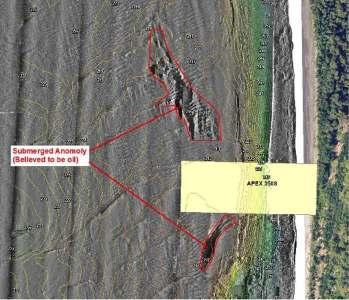
7 Incident Site
8 Incident Objectives O B J E C T I V E S : P R O V I D E F O R T H E S A F E T Y A N D W E L F A R E O F C I T I Z E N S A N D R E S P O N S E P E R S O N N E L I N I T I AT E A C T I O N S T O S T O P O R C O N T R O L T H E S O U R C E, A N D M I N I M I Z E T H E T O T A L V O L U M E R E L E A S E D C O N T A I N, T R E AT A N D R E C O V E R S P I L L E D M AT E R I A L S F R O M T H E W AT E R. C O N D U C T A N A S S E S S M E N T A N D I N I T I AT E S H O R E L I N E C L E A N U P E F F O R T S C O N D U C T A S U R V E Y O F T H E D A M A G E T O B A R G E A P E X M I N I M I Z E I M P A C T S T O M A R I N E T R A N S P O R T AT I O N S Y S T E M M I N I M I Z E E C O N O M I C I M P A C T I D E N T I F Y A N D P R O T E C T R E S O U R C E S AT R I S K D U R I N G T H E A S S E S S M E N T A N D R E C O V E R Y O P E R AT I O N S O F A N Y I D E N T I F I E D S U B M E R G E D O I L. C O N T I N U E E N V I R O N M E N T A L M O N I T O R I N G. P R I O R I T I E S : S A F E T Y O F P U B L I C / C O M M U N I T I E S E N V I R O N M E N T A L C O N C E R N S R E O P E N I N G O F R I V E R W I T H S U B S E Q U E N T M O V E M E N T O F M A R I T I M E T R A F F I C
9 Incident Challenges Incident Location Environment Connectivity Product Fate Specialized Equipment Traffic Management Timing Staging ICP
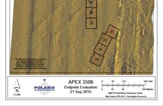
10 Incident Summary (Type II) Unified Command included: FOSCR CDR Mark Sawyer MSU Paducah RPIC Jason Adams / Greg Brown Inland Marine Services SOSC- Robert Francis / Kevin Strohmeier KY Dept. of Environmental Protection Number of OPS period: 8 Number of days : 23 2 SEP15 25 SEP 15 River Closure: 18 miles (48 hours) Oil Released: 120,588 gallons Experts believe majority of product was confined in two anomalies near incident location Detection: Combination of low resolution and high resolution side scan sonar, along with over flight and dive ops were used. Number of water & sediment samples : 220 Number of samples positive for oil : 5 Total Personnel Responded : 120+ Including USCG (IMAT/NSF), NOAA, EPA,OSRO- SWS, T&T Type of product: Clarified Slurry Oil, Group V Residual Fuels Oils (GPVFRO) referred to by industry as LAPIO (Low API Oils) Recovery: Combination of Cable Arm Environmental Bucket with ClamVisiondredge positioning system, VesselSubmerged Oil Recovery System (VSORS)and a Decanting water polishing processes were used. Outcome After Recovery: BothAnomalies were determined to have nomore than 10% sporadic oil distributionwithin each 25 meter by 25 meter grid on 25 SEP 15. Total Equipment Responded :65 + Including Various barges and tug boats, 18ft- 25ft response boats, dive boats, aircraft and cranes Resources at risk: 2 (USFWS) ESA listed freshwater mussels Oily sediment/water recovered : 3,111Cubic Yards (~4,667 tons) Oily Sediment recovered (after decanting): 2,261 Cubic Yards (~3,392) FPN Ceiling: $300 K Costs as of 30 SEP 15: Indirect $281,437 - Direct $193,308 Total $474,745 RP-Actual as of 25SEP15 : 10 $2.9 million
11 RESOURCES AT RISK U.S. Fish and Wildlife Service (USFWS) identified two ESA listed freshwater mussels, commonly referred to as the Fat Pocketbook and Pink Mucket, at greatest potential risk within the action area. USFWS requested a species and habitat survey of the area prior to commencement of recovery operations. A mussel survey was completed on 7 Sep 15 and concluded that the action area did not contain any suitable habitat for these mussels. However, mussel observations were conducted during the recovery operations on behalf of USFWS and no mussels were observed. The Bureau of Indian Affairs concluded no impact to the trust resources within the action area. As per Section 106 of the NHPA, the State of Kentucky Heritage Council and State Historic Preservation Office (SHPO) initially indicated potential for impacts to trust resources, however once the action area was refined to on-water activities to remove sunken oil, they concluded that recovery actions were not likely to impact historic and archeological resources.
12 PRODUCT-Clarified Slurry Oil Information on the oil provided in the safety data sheet indicated that the spilled slurry oil had a specific gravity of 1.1. Oils of this type are typically classified as Group V Oils which are known to sink in freshwater. Group V Residual fuels Oils ( GPVRFO) referred to by industry as LAPIO (Low API Oils) RCRA Information: unused product is not specifically listed by the EPA as a hazardous waste. It does not exhibit the hazardous characteristics of ignitability, corrosivity, or reactivity (ExxonMobil MSDS) DOT Haz Class: Combustible Liquids ID Number: NA1270 ERG Number: 1287 Boiling Point: 400 F Needs to be heated to ~120 F to pump from barge
13 Product Demo

14 Low Resolution SSS from 4-7SEP15

15 High Resolution SSS 07SEP15

16


17 Clamshell & Clam vision


18 Clam Vision Data Results


19 Recovered Oily Sediment


20 Decanting / Water Polishing


21 High Resolution SSS Before


22 High Resolution SSS After
23 Incident Summary (Type II) Unified Command included: FOSCR CDR Mark Sawyer MSU Paducah RPIC Jason Adams / Greg Brown Inland Marine Services SOSC- Robert Francis / Kevin Strohmeier KY Dept. of Environmental Protection Number of OPS period: 8 Number of days : 23 2 SEP15 25 SEP 15 River Closure: 18 miles (48 hours) Oil Released: 120,588 gallons Experts believe majority of product was confined in two anomalies near incident location Detection: Combination of low resolution and high resolution side scan sonar, along with over flight and dive ops were used. Number of water & sediment samples : 220 Number of samples positive for oil : 5 Total Personnel Responded : 120+ Including USCG (IMAT/NSF), NOAA, EPA,OSRO- SWS, T&T Type of product: Clarified Slurry Oil, Group V Residual Fuels Oils (GPVFRO) referred to by industry as LAPIO (Low API Oils) Recovery: Combination of Cable Arm Environmental Bucket with ClamVisiondredge positioning system, VesselSubmerged Oil Recovery System (VSORS)and a Decanting water polishing processes were used. Outcome After Recovery: BothAnomalies were determined to have nomore than 10% sporadic oil distributionwithin each 25 meter by 25 meter grid on 25 SEP 15. Total Equipment Responded :65 + Including Various barges and tug boats, 18ft- 25ft response boats, dive boats, aircraft and cranes Resources at risk: 2 (USFWS) ESA listed freshwater mussels Oily sediment/water recovered : 3,111Cubic Yards (~4,667 tons) Oily Sediment recovered (after decanting): 2,261 Cubic Yards (~3,392) FPN Ceiling: $300 K Costs as of 30 SEP 15: Indirect $281,437 - Direct $193,308 Total $474,745 RP-Actual as of 25SEP15 : 23 $2.9 million
24 Lesson Learned Benefit of Salvage and Marine Firefighting Regs: unique position for submerged oils State/local asset awareness Robust Environmental Specialist Unit and SSC Support MTSRU establishment & make-up External resourcing/consultation (IMAT, EPA, State, RRT, Strike Team, USFWS) ERMA & CG need for standard COP system Develop local FOSC Guide & ICS software proficiency Unified, Unified Command HSIN/JIC establishment & Info Management


25
Lessons Learned from Fish Spawning Reef Restoration in the St. Clair Detroit River System. Photo Credit: Adam Lintz
 Lessons Learned from Fish Spawning Reef Restoration in the St. Clair Detroit River System Photo Credit: Adam Lintz Outline and Presenters Jennifer Read, University of Michigan Water Center Introduction
GIS in Response to Oil Spills and other Deleterious Materials
 GIS in Response to Oil Spills and other Deleterious Materials Judd Muskat California Department of Fish and Wildlife Office of Spill Prevention and Response What I Will Cover Office of Spill Prevention
Coastal Response Research Center. Nancy Kinner University of New Hampshire (UNH) Michele Jacobi NOAA ORR. September 27, 2007
 Michele Jacobi NOAA ORR. September 27, 2007") Coastal Response Research Center Nancy Kinner University of New Hampshire (UNH) Michele Jacobi NOAA ORR September 27, 2007 1 Coastal Response Research Center (CRRC) CRRC is partnership between NOAA s Office
Coastal Response Research Center Nancy Kinner University of New Hampshire (UNH) Michele Jacobi NOAA ORR September 27, 2007 1 Coastal Response Research Center (CRRC) CRRC is partnership between NOAA s Office
CRRT Meeting St. Thomas, USVI June 15-16, 2016
 CRRT Meeting St. Thomas, USVI June 15-16, 2016 } Finalized in February, but not posted on the old CRRT website. } Posted on the new CRRT website at: www.nrt.org/crrtplans } Added and Rearranged Appendices
Environmental Response Management Application
 Environmental Response Management Application Coastal Response Research Center Nancy Kinner, Michele Jacobi, Rob Braswell, Kurt Schwehr & Amy Merten RRT III May 14, 2008 1 Talk Outline Overview of Center
Parish of Ascension. ASCENSION PARISH SITUATIONAL REPORT 06 August 2008 As of: 1600 Hours
 Parish of Ascension OFFICE OF HOMELAND SECURITY AND EMERGENCY PREPAREDNESS Tommy Martinez Parish President Richard A. Webre Director ASCENSION PARISH SITUATIONAL REPORT 06 August 2008 As of: 1600 Hours
Geographic Response Plan Mapping and Digital Area Contingency Plan
 Geographic Response Plan Mapping and Digital Area Contingency Plan Ryan Druyor Digital ACP Coordinator Florida Fish and Wildlife Conservation Commission Fish and Wildlife Research Institute Background
Andy Mahoney, Hajo Eicken, Josh Jones
 First Annual Partners Meeting Presentation Integrated Framework to Identify, Track and Communicate Sea-Ice Hazards Arctic Domain Awareness Center (ADAC) A DHS Center of Excellence Andy Mahoney, Hajo Eicken,
Submerged Oil Recovery Systems and Recommendations. RDC Kurt Hansen Regional Response Team 5 Minneapolis, MN April 30, 2014
 Submerged Oil Recovery Systems and Recommendations RDC Kurt Hansen Regional Response Team 5 Minneapolis, MN April 30, 2014 Outline Submerged Oil Background Past R&D Related Efforts Project at USCG RDC
Financial concerns Regulatory developments Superfund, Resource Conservation and Recovery Act (RCRA) frame Industry Reactions
 frame Industry Reactions") Hazardous Materials Management Background Episodic Events: 1979 - Three Mile Island - Harrisburg, Pennsylvania Partial meltdown of radioactive core Lessons Technological systems can fail in unexpected
Hazardous Materials Management Background Episodic Events: 1979 - Three Mile Island - Harrisburg, Pennsylvania Partial meltdown of radioactive core Lessons Technological systems can fail in unexpected
Alaska Natural Resource Governance
 Alaska Natural Resource Governance &SpillResponse Rutgers University Arctic Studio E.J. Bloustein School of Planning & Public Policy New Brunswick, NJ Presenting: Prof. Hal Salzman Ronit Anspach, Matt
BURGAS CASE STUDY: LAND-SEA INTERACTIONS. Dr. Margarita Stancheva
 BURGAS CASE STUDY: LAND-SEA INTERACTIONS Dr. Margarita Stancheva Name of presentation NEED FOR COHERENCE BETWEEN LAND AND SEA ACTIVITIES Name presenter Burgas is the fourth largest city in Bulgaria and
3Chapter Three: Rescue and Response
 17 16 Report Science Title and the Storms: the USGS Response to the Hurricanes of 2005 3Chapter Three: Rescue and Response This chapter documents the U.S. Geological Survey s (USGS) humanitarian rescue
Monday, November 5, :30 a.m. EST
 Monday, November 5, 2018 8:30 a.m. EST Significant Activity Nov 3-5 Significant Events: Tropical Cyclone Yutu Recovery Tropical Activity: Atlantic No new tropical cyclones are expected during the next
Daily Operations Briefing. Friday, May 5, :30 a.m. EDT
 Daily Operations Briefing Friday, May 5, 2017 8:30 a.m. EDT Significant Activity May 4-5 Significant Events: Flooding Southern/Central Plains Significant Weather: Flash flooding possible Mid-Atlantic through
Marine Debris in the Gulf of Mexico
 Marine Debris in the Gulf of Mexico Peter Murphy NOAA Marine Debris Program / Genwest Biloxi, Mississippi October 25, 2009 Outline 1. Project Background 2. Process 3. 2006-2007 Alabama, Mississippi 4.
Hurricane Katrina and Oil Spills: Impact on Coastal and Ocean Environments
 Archived version from NCDOCKS Institutional Repository http://libres.uncg.edu/ir/asu/ Pine, J. C. (June 2006). Hurricane Katrina and oil spills: Impact on coastal and ocean environments. Oceanography,
Lessons Learned and Shared
 Lessons Learned and Shared Plan for the worst. Hope for the best. Remember that hope is not a strategy. Agnes 8 Lessons 1. Identify Susceptible Communities 2. Develop a Plan 3. Threat Recognition 4. Review
United States Multi-Hazard Early Warning System
 United States Multi-Hazard Early Warning System Saving Lives Through Partnership Lynn Maximuk National Weather Service Director, Central Region Kansas City, Missouri America s s Weather Enterprise: Protecting
STEUBEN COUNTY, NEW YORK. Hazard Analysis Report
 STEUBEN COUNTY, NEW YORK Hazard Analysis Report Prepared by: April 1, 2014 Background On April 1, 2014 the Steuben County Office of Emergency Management conducted a hazard analysis using the automated
Unmanned Aircraft Systems (UAS) Activities in Earth Sciences
 Activities in Earth Sciences") Unmanned Aircraft Systems (UAS) Activities in Earth Sciences Bruce K. Quirk quirk@usgs.gov Department of the Interior U.S. Geological Survey June 22, 2015 Department of the Interior Bureau of Land Management
Unmanned Aircraft Systems (UAS) Activities in Earth Sciences Bruce K. Quirk quirk@usgs.gov Department of the Interior U.S. Geological Survey June 22, 2015 Department of the Interior Bureau of Land Management
Title: NOAA National Ocean Service Response Team efforts during the 2004 Hurricane Season
 Title: NOAA National Ocean Service Response Team efforts during the 2004 Hurricane Season LCDR Rick Fletcher, OCS/NOS/NOAA Abstract: The 2004 Atlantic Hurricane Season has been one of the most active and
Monday, November 19, :30 a.m. EST
 Monday, November 19, 2018 8:30 a.m. EST Significant Activity Nov 16-19 Significant Events: CA Wildfires Tropical Activity: Atlantic No new tropical cyclones are expected during the next 5 days Eastern
Drilling & Fracking a well near Grass River: Notes from an informal conversation with O.I.L. Energy
 Torch, Clam, & Bellaire Lakes www.3lakes.com Drilling & Fracking a well near Grass River: Notes from an informal conversation with O.I.L. Energy Dean Branson and Gary Knapp, June 26, 2014 Given that Michigan
Daily Operations Briefing. Wednesday, February 19, :30 a.m. EST
 Daily Operations Briefing Wednesday, February 19, 2014 8:30 a.m. EST Disaster Amendments Amendment Effective Date Action A B C D E F G Debris Removal Emergency Protective Measures Road Systems & Bridges
17-20 November 2007 Incidental Take Monitoring Methodology and Results
 Sample Site Selection Protocol 17-20 November 2007 Incidental Take Monitoring Methodology and Results On 16 November 2007, the U.S. Fish and Wildlife Service (USFWS) provided the USACE Mobile District
Paper Maintenance of the Panama Canal Navigational Channels
 Abstract: Paper 142 - Maintenance of the Panama Canal Navigational Channels Rogelio A. Gordon Panama Canal Authority, Panama, Republic of Panama opd@pancanal.com The Panama Canal provides a safe and expedite
Best Practices Protocol for Methamphetamine Clandestine Labs
 Best Practices Protocol for Methamphetamine Clandestine Labs Diane Catley Forensic Science Supervisor Virginia Dept. of Forensic Science 6600 Northside High School Drive Roanoke VA 24019 540.283.5931 May,
Grand Canyon Sediment Augmentation Study. Tim Randle, P.E. Manager, Sedimentation and River Hydraulics Group, Denver, Colorado
 Grand Canyon Sediment Augmentation Study Tim Randle, P.E. Manager, Sedimentation and River Hydraulics Group, Denver, Colorado Sediment Augmentation Objectives Seasonally increase turbidity to provide cover
Remote Sensing Techniques for Renewable Energy Projects. Dr Stuart Clough APEM Ltd
 Remote Sensing Techniques for Renewable Energy Projects Dr Stuart Clough APEM Ltd What is Remote Sensing? The use of aerial sensors to detect and classify objects on Earth Remote sensing for ecological
SCOAR Amelia Island Meeting October Douglas Schetzel, Director, Project Engineering Tony Ruckriegel, Manager, Contracts/Major Capital Projects
 SCOAR Amelia Island Meeting October 2017 Douglas Schetzel, Director, Project Engineering Tony Ruckriegel, Manager, Contracts/Major Capital Projects LG&E and KU Overview Headquartered in Louisville, Ky.
Daily Operations Briefing. Wednesday, September 10, :30 a.m. EDT
 Daily Operations Briefing Wednesday, September 10, 2014 8:30 a.m. EDT Significant Activity: Sep 9 10 Significant Events: Flooding - Desert Southwest Tropical Activity: Atlantic Disturbance 1 (Low, 20%);
Lake Sedimentation Survey of Siloam Springs State Park Lake, Adams County, Illinois
 Contract Report 567 Lake Sedimentation Survey of Siloam Springs State Park Lake, Adams County, Illinois by Richard L. Allgire Office of Sediment & Wetland Studies Prepared for the Illinois Department of
SUMMARY OF SCIENTIFIC STUDY RESULTS SUPPORTING THE FEDERAL POSITION ON MC-20 SITE
 SUMMARY OF SCIENTIFIC STUDY RESULTS SUPPORTING THE FEDERAL POSITION ON MC-20 SITE 10-23-2018 The united Federal position on the MC-20 site is as follows, with summaries of the studies relied upon to reach
Safe Method of Use 2 Workshop and Arts Studios
 Safe Method of Use 2 Workshop and Arts Studios Purpose: This Safe Method of Use applies to principal investigators (PIs), sector managers, designated laboratory person (DLPs), technical staff and students
Response Case Study: April 2014 Historic Flood Event. Severe Weather April 29 30, 2014
 Response Case Study: April 2014 Historic Flood Event NOAA s Regional Preparedness Training (NRPT) Natural Disaster Causing Technology Disasters in Mobile Bay Area Kimberly Albins Gulf of Mexico Regional
A Scientific Basis for Restoring Fish Spawning Habitat in the St. Clair and Detroit Rivers of the Laurentian Great Lakes
 A Scientific Basis for Restoring Fish Spawning Habitat in the St. Clair and Detroit Rivers of the Laurentian Great Lakes National Conference on Ecosystem Restoration April 18-22, 2016 Coral Springs, Florida
QUANTIFYING RESILIENCE-BASED IMPORTANCE MEASURES USING BAYESIAN KERNEL METHODS
 QUANTIFYING RESILIENCE-BASED IMPORTANCE MEASURES USING BAYESIAN KERNEL METHODS Hiba Baroud, Ph.D. Civil and Environmental Engineering Vanderbilt University Thursday, May 19, 2016 WHAT IS RESILIENCE? Photo:
Hurricane Season 2010 & NOAA s Deepwater Response
 Hurricane Season 2010 & NOAA s Deepwater Response What s Happened? What Will 2010 Bring? Possible Shoreline Effects Darin Figurskey Meteorologist-in-Charge NOAA s NWS Raleigh, NC NOAA s National Weather
Public Notice. Latitude: Longitude: Minute Quad: Covington, KY
 Public Notice US Army Corps of Engineers Louisville District Public Notice No. LRL-2018-642-cat Date: 9 Aug 2018 Closing Date: 10 Sep 2018 Please address all comments and inquiries to: U.S. Army Corps
Case 2:18-cv ILRL-MBN Document 1-3 Filed 12/20/18 Page 1 of 14
 Case 2:18-cv-14046-ILRL-MBN Document 1-3 Filed 12/20/18 Page 1 of 14 Case 2:18-cv-14046-ILRL-MBN Document 1-3 Filed 12/20/18 Page 2 of 14 Case 2:18-cv-14046-ILRL-MBN Document 1-3 Filed 12/20/18 Page 3
Hurricane Readiness for Coastal Communities
 Hurricane Readiness for Participant Guide Developed for: Federal Emergency Management Agency Emergency Management Institute 16825 South Seton Avenue Emmitsburg, MD 21727-8998 Developed by: C² Technologies,
Overview of Methods. Terrestrial areas that are most important for conservation Conservation
 Overview of Methods The goal of the Western Lake Erie Coastal Conservation Vision project (WLECCV) is to define where we should be working locally to optimally achieve regional conservation impact. The
Relatively little hard substrate occurs naturally in the
 CHAPTER FIVE Rock Habitats Relatively little hard substrate occurs naturally in the estuary, owing mainly to the vast quantities of fine sediment that have been deposited by the rivers. Rock habitat is
Monday, September 24, :30 a.m. EDT
 Monday, September 24, 2018 8:30 a.m. EDT Significant Activity Sep 21-24 Significant Events: Hurricane Florence response Tropical Activity: Atlantic Subtropical Storm Leslie; Tropical Disturbance Kirk;
THIN-LAYER PLACEMENT OF DREDGE MATERIAL FOR MARSH NOURISHMENT, RESOTRATION, AND RESPONSE TO SEA LEVEL RISE
 THIN-LAYER PLACEMENT OF DREDGE MATERIAL FOR MARSH NOURISHMENT, RESOTRATION, AND RESPONSE TO SEA LEVEL RISE Case studies and lesson learned regarding thin-layer deposition projects in Delaware, New Jersey,
Wastewater Treatment Plant Chemical Perspectives. Presented By: Brian Villacorta, P.E., BCEE Los Angeles County Sanitation Districts
 Wastewater Treatment Plant Chemical Perspectives Presented By: Brian Villacorta, P.E., BCEE Los Angeles County Sanitation Districts EARLY CIVILIZATIONS AND CHEMICAL TREATMENT 1500 BC Wall images found
AFRCC AIR FORCE RESCUE COORDINATION CENTER
 AFRCC AIR FORCE RESCUE COORDINATION CENTER 2003 ANNUAL REPORT AFRCC ANNUAL REPORT TABLE OF CONTENTS AFRCC Mission Statement and Charter... 3 Organizational Chart... 4 Commander's Comments... 5 2003 AFRCC
Background. North Cascades Ecosystem Grizzly Bear Restoration Plan/ Environmental Impact Statement. Steve Rochetta
 Grizzly Bear Restoration Plan/ Environmental Impact Statement Steve Rochetta Background Situated in the core of the North Cascades ecosystem (NCE), the North Cascades National Park Complex is surrounded
PRECAP. Rivers Breakout Session Final Presentation CAPSTONE 14
 Rivers Breakout Session Final Presentation CAPSTONE 14 Rivers Session Team -Army Corps of Engineers -3 Divisions, 4 Districts -Navigation & Emergency Management -U.S. Coast Guard -U.S. Department of Transportation
MeteoGroup RoadMaster. The world s leading winter road weather solution
 MeteoGroup RoadMaster The world s leading winter road weather solution Discover why RoadMaster is the world s leading winter road weather solution. Managing winter road maintenance means that you carry
Daily Operations Briefing. Wednesday, May 21, :30 a.m. EDT
 Daily Operations Briefing Wednesday, May 21, 2014 8:30 a.m. EDT Significant Activity: May 20 21 Significant Events: Slide Fire - Arizona Significant Weather: Slight risk of severe thunderstorms Rockies,
HazMatIQ Above The Line/Below The Line Course Description
 2014-2015 HazMatIQ Above The Line/Below The Line Course Description! WeWillNeverForget www.hazmatiq.com info@hazmatiq.com 800 518 9895 Table of Contents Course Description... 3 Target Audience... 3 Pre-
April 9, Phosphate Mining and Reclamation Overview
 April 9, 2012 Phosphate Mining and Reclamation Overview Business & Mission Mosaic produces the majority of the phosphate used by American farmers Employs approximately 7,000 people worldwide, 3,000 in
University of New Hampshire Scholars' Repository
 University of New Hampshire University of New Hampshire Scholars' Repository Center for Coastal and Ocean Mapping Center for Coastal and Ocean Mapping 3-2009 Environmental Response Management Application
Hazard Communication & Chemical Safety. Based on OSHA Standard
 Hazard Communication & Chemical Safety Based on OSHA Standard 1910.1200 We use many chemicals We want you to know how to use them safely You will learn about The Hazards of Chemicals Our Written Program
Risk-Based Visual Analytics for Maritime Resource Alloction. Navajo Tech. GaTech JSU. Swansea U Austin FIU. November 2011
 Risk-Based Visual Analytics for Maritime Resource Alloction SFU, JIBC UBC UW Stanford Navajo Tech Purdue Penn St. Ind U VaTech NC UNCC A&T GaTech JSU U Stuttgart UT UHD Swansea U Austin FIU Motivation
Water Temperature Monitoring of the Klamath River Mainstem
 Water Temperature Monitoring of the Klamath River Mainstem Progress Report #3 Prepared by Robert Rohde and Leaf Hillman with assistance provided by Susan Smith and William Tripp Karuk Tribe of California
Daily Operations Briefing Tuesday, December 23, :30 a.m. EST
 Daily Operations Briefing Tuesday, December 23, 2014 8:30 a.m. EST Significant Activity: Dec 22-23 Significant Events: No significant activity Significant Weather: Slight risk of severe thunderstorms and
Daily Operations Briefing Thursday, January 8, :30 a.m. EST
 Daily Operations Briefing Thursday, January 8, 2015 8:30 a.m. EST Significant Activity: Jan 7-8 Significant Events: None Significant Weather: Snow Northern Rockies to Central Plains; Upper Mississippi
Parks Canada s Geomatics Infrastructure
 Parks Canada s Geomatics Infrastructure Esri Canada User Conference Ottawa, Canada -- October 15, 2014 Presented By: Brock Fraser National Geomatics Coordinator, Parks Canada. Parks Canada Protects and
Flood Risk Mapping and Forecasting in England
 Flood Risk Mapping and Forecasting in England Mark Franklin Environment Agency, England NORDESS Workshop on Risk Assessment and Acceptable Risk Outline Flood risk in England Who we are and how we work
Incident Status Summary (ICS-209)
") 1. Incident Name: 2. Incident Number: Spillway - DWR Assist 3. Report Version (check one box): Initial X Update Final 7. Current Incident Size or Area Involved (use unit label e.g., Acres, Square Miles
1. Incident Name: 2. Incident Number: Spillway - DWR Assist 3. Report Version (check one box): Initial X Update Final 7. Current Incident Size or Area Involved (use unit label e.g., Acres, Square Miles
C h a p t e r 5 : W o r k p l a c e H a z a r d o u s M a t e r i a l s I n f o r m a t i o n S y s t e m ( W H M I S )
") C h a p t e r 5 : W o r k p l a c e H a z a r d o u s M a t e r i a l s I n f o r m a t i o n S y s t e m ( W H M I S ) Overview WHMIS is a provincial legislative response to provincial employees and employers
C h a p t e r 5 : W o r k p l a c e H a z a r d o u s M a t e r i a l s I n f o r m a t i o n S y s t e m ( W H M I S ) Overview WHMIS is a provincial legislative response to provincial employees and employers
City of Auburn s Wireless Initiative. Presentation to the Auburn City Council Committee of the Whole April 18, 2006
 City of Auburn s Wireless Initiative Presentation to the Auburn City Council Committee of the Whole April 18, 2006 Traffic Statistics for the City of Auburn Web Site For the period October 1, 2005 to April
Environment and Natural Resources Trust Fund 2019 Request for Proposals (RFP)
") Environment and Natural Resources Trust Fund 2019 Request for Proposals (RFP) Project Title: Data Visualization Tool for Minnesota Riverbed Habitat Category: A. Foundational Natural Resource Data and Information
Environment and Natural Resources Trust Fund 2019 Request for Proposals (RFP) Project Title: Data Visualization Tool for Minnesota Riverbed Habitat Category: A. Foundational Natural Resource Data and Information
Sunday, March 24, :30 a.m. EDT
 Sunday, March 24, 2019 8:30 a.m. EDT Significant Activity Mar 23-24 Significant Events: Flooding Central U.S. Tropical Activity: No activity affecting U.S. interests Significant Weather: Severe thunderstorms
Oyster Reef for Shoreline Stabilization and Restoration. Jason Kirkpatrick Conservation Program Manager MacDill AFB Tampa, Florida
 Oyster Reef for Shoreline Stabilization and Restoration Jason Kirkpatrick Conservation Program Manager MacDill AFB Tampa, Florida Interbay Penninsula Port of Tampa X The few remaining mangroves are being
Heather Schlosser Army Corps of Engineers Coastal Studies Group August 28, 2008
 Got sand? Regional Sediment Management in Orange County Heather Schlosser Army Corps of Engineers Coastal Studies Group August 28, 2008 Regional Sediment Management Regional sediment management recognizes
Climate Change Impacts in Alaska: the Weather Perspective
 Climate Change Impacts in Alaska: the Weather Perspective September 18, 2007 NOAA s National Weather Service, Alaska Region James Partain, Chief Environmental and Scientific Services Division NOAA NWS
Daily Operations Briefing. Saturday, June 21, :30 a.m. EDT
 Daily Operations Briefing Saturday, June 21, 2014 8:30 a.m. EDT Significant Activity: June 20 21 Significant Events: Severe Weather/Flooding Upper Midwest (Final) Tropical Activity: Atlantic Area 1 Low
BURGAS CASE STUDY: LAND-SEA INTERACTIONS
 BURGAS CASE STUDY: LAND-SEA INTERACTIONS Dr. Margarita Stancheva IO-BAS, Bulgaria Name of presentation CROSS BORDER MARITIME SPATIAL PLANNING IN THE BLACK SEA ROMANIA AND BULGARIA (MARSPLAN BS) Project
Erosion Information Paper Eagle City and Eagle Village, Alaska Current as of January 21, 2008
 U.S. Army Corps of Engineers ALASKA BASELINE EROSION ASSESSMENT Erosion Information Paper Eagle City and Eagle Village, Alaska Current as of January 21, 2008 Community Information The City of Eagle, population
Daily Operations Briefing. Thursday, March 27, :30 a.m. EDT
 Daily Operations Briefing Thursday, March 27, 2014 8:30 a.m. EDT Significant Activity: Mar 26 27 Significant Events: Mudslide Snohomish County, WA Fire Boston, MA Significant Weather: Slight risk of severe
2012 USACE Drought Actions
 2012 USACE Drought Actions for Inland Waterway Users Board 68 Jim Walker Navigation Branch Chief 19 December 2012 US US Army Corps of of Engineers US Drought Monitor 1 2 3 4 6 5 Impacts: 1. The area in
We are interconnected, we are resilient As air temperatures warm forests change, fires increase glaciers retreat, snowpack diminishes sediment
 We are interconnected, we are resilient As air temperatures warm forests change, fires increase glaciers retreat, snowpack diminishes sediment increases rivers change, salmon respond base sea level rises
President s Day Weekend Storm Community Meeting and Workshop April 17, 2017
 President s Day Weekend Storm Community Meeting and Workshop April 17, 2017 Meeting outline 1. Progress update on the City of San Jose s recovery efforts 2. Water district presentation on: Weather situation
January Submitted by: 2200 Commonwealth Blvd, Suite 300 Ann Arbor, MI Ph: Fax:
 BOARDMAN RIVER FEASIBILITY STUDY A Report on Boardman River Existing Sediment Chemistry Data January 2009 Submitted by: 2200 Commonwealth Blvd, Suite 300 Ann Arbor, MI 48105 Ph: 734-769-3004 Fax: 734-769-3164
Red River Levee Panel
 Red River Levee Panel Mississippi River Commission Monday, August 9, 2017 Red River Levees in LA & AR NONE along TX & OK Boarder Red River Levee Issues Caddo Levee Cherokee Park Authorization Bossier Levee
Feasibility Study for Potential Removal of McLane & Goldman Dams Souhegan River, Milford, NH. Public Kick-off Meeting
 Feasibility Study for Potential Removal of McLane & Goldman Dams Souhegan River, Milford, NH Public Kick-off Meeting Mark Wamser Gomez and Sullivan Engineers, P.C. 603-428-4960 Aug 16, 2010 Agenda Opening
RAILROAD COMMISSION OF TEXAS OIL WELL POTENTIAL TEST, COMPLETION OR RECOMPLETION REPORT, AND LOG
 RAILROAD COMMISSION OF TEXAS 1701 N. Congress P.O. Box 12967 Austin, Texas 78701-2967 Status: Form W-2 OIL WELL POTENTIAL TEST, COMPLETION OR RECOMPLETION REPORT, AND LOG Date: Tracking.: Approved 01/05/2016
Development of an International Arctic Observations Assessment Framework
 Development of an International Arctic Observations Assessment Framework Dr. Steven Lev, Dr. Jason Gallo Briefing for the Sustaining Arctic Observing Networks (SAON) April 7, 2017 International Partners
Looking Ahead to Chapter 4
 Looking Ahead to Chapter Focus In Chapter, you will learn about functions and function notation, and you will find the domain and range of a function. You will also learn about real numbers and their properties,
Regulations concerning protection of Bjørnøya Nature Reserve in Svalbard
 Regulations concerning protection of Bjørnøya Nature Reserve in Svalbard Laid down by the Royal Decree of 16 August 2002 pursuant to sections 12 and 17 of the Act of 15 June 2001 No. 79 relating to the
Daily Operations Briefing Tuesday, March 10, :30 a.m. EDT
 Daily Operations Briefing Tuesday, March 10, 2015 8:30 a.m. EDT Significant Activity: Mar 9 10 Significant Events: None Significant Weather: Rain and thunderstorms Gulf Coast to Mid-Atlantic and Southeast
Bias in the Corps Report
 Bias in Corps of Engineers Inland Navigation Traffic Forecasts and Recent Congressional Testimony prepared by Public Employees for Environmental Responsibility (PEER) June 2001 Introduction "I know that
MATERIAL SAFETY DATA SHEET
 Boxing Wax - Thin - Niranium Page 1 MATERIAL SAFETY DATA SHEET 1. CHEMICAL PRODUCT AND COMPANY IDENTIFICATION Product Identification Product Name: Boxing Wax - Thin - Niranium Product Number: 807067 Chemical
Storage, Handling & Safe Use of Chemicals and Hazardous Materials
 Training Title Storage, Handling & Safe Use of Chemicals and Hazardous Materials Training Duration 5 days Training Venue and Dates Storage, Handling and Safe Use of Chemical Handling and Hazardous Materials
Safe Method of Use 1 General Exempt Laboratory Requirements
 Safe Method of Use 1 General Exempt Laboratory Requirements Purpose: This Safe Method of Use applies to principal investigators (PIs), sector managers, designated laboratory person (DLPs), technical staff
ADVENTURES IN WATER DEVELOPED BY LOUISVILLE WATER COMPANY
 ADVENTURES IN WATER DEVELOPED BY LOUISVILLE WATER COMPANY Tunneling for Water explains the science behind a first-of-its-kind project in the world! Louisville Water Company is the first water utility
STORAGE, HANDLING & SAFE USE OF CHEMICALS AND HAZARDOUS MATERIALS
 Training Title STORAGE, HANDLING & SAFE USE OF CHEMICALS AND HAZARDOUS MATERIALS Training Duration 5 days Training Venue and Dates Storage, Handling and Safe Use of Chemicals and Hazardous Materials In
FORECAST-BASED OPERATIONS AT FOLSOM DAM AND LAKE
 FORECAST-BASED OPERATIONS AT FOLSOM DAM AND LAKE 255 237 237 237 217 217 217 200 200 200 0 163 131 Bridging the Gap163Conference 255 0 132 255 0 163 122 The Dana on Mission Bay San Diego, CA January 28,
Dalton Highway Flood - Disaster in the Arctic
 Dalton Highway Flood - Disaster in the Arctic The impacts of the ice and flooding were dramatic: 24 miles of the road were impacted; 28 days the road was closed; Two state disaster declarations issued;
GIS-T 2010 Building a Successful Geospatial Data Sharing Framework: A Ohio DOT Success Story
 GIS-T 2010 Building a Successful Geospatial Data Sharing Framework: A Ohio DOT Success Story ODOT District 2 GIS John Puente District 1 GIS Coordinator\ Planning Administrator 2 Interoperability 3 District
USS Arizona Drawings and Underwater GPS Surveys Linked by ArcIMS
 ESRI UC2004 USS Arizona Drawings and Underwater GPS Surveys Linked by ArcIMS Tim Smith National Park Service Matt Brown Northrop Grumman Information Technology Outline! Introduction! Geodatabase Development!
Sediment Deposition LET THE RIVER RUN T E A C H E R. Activity Overview. Activity at a Glance. Time Required. Level of Complexity.
 Activity at a Glance Grade: 6 9 Subject: Science Category: Physical Science, Earth Science Topic: Deposition, River Systems Time Required Two 45-minute periods Level of Complexity Medium Materials* TI-73
Environmental Data In Support of Search & Rescue Operations in the Central Mediterranean Sea
 Environmental Data In Support of Search & Rescue Operations in the Central Mediterranean Sea Dr. Eric Comerma (RPS ASA) eric.comerma@rpsgroup.com Cathleen Turner (RPS ASA) Prof. Aldo Drago (Univ. of Malta)
ENVIRONMENTAL DIVISION Arkansas State Highway and Transportation Department. Streamlining Environmental Assessment through GIS
 ENVIRONMENTAL DIVISION Arkansas State Highway and Transportation Department Streamlining Environmental Assessment through GIS 2 September, 2003 ARKANSAS STATE HIGHWAY AND TRANSPORTATION DEPARTMENT ENVIRONMENTAL
Daily Operations Briefing Friday, November 25, :30 a.m. EST
 Daily Operations Briefing Friday, November 25, 2016 8:30 a.m. EST Significant Activity Nov 24-25 Significant Events: Water Contamination Tropical Activity: Atlantic Tropical cyclone activity not expected
Daily Operations Briefing Friday, April 3, :30 a.m. EDT
 Daily Operations Briefing Friday, April 3, 2015 8:30 a.m. EDT Significant Activity: Apr 2 3 Significant Events: None Significant Weather: Heavy rain and enhanced severe weather outlook: Lower Mississippi