SAFMC Habitat and Ecosystem IMS. Habitat and Environmental Protection Advisory Panel Meeting
|
|
|
- Candice Montgomery
- 6 years ago
- Views:
Transcription


1 SAFMC Habitat and Ecosystem IMS Habitat and Environmental Protection Advisory Panel Meeting Charleston, SC November 18, 2008

 Phase 5 Expand EcoSpecies and EcoResearch projects, transition to ArcGIS Server")
2 Project Overview Phase 1 develop and host an Internet Map Server (IMS) application to provide access to related GIS data Phase 2 develop a Habitat and Ecosystem Homepage to distribute information concerning the Council s move to Ecosystem-Based Management Phase 3 transition homepage to a Portal application to facilitate development of a Fishery Ecosystem Plan Phase 4 EcoSpecies, EcoResearch, EcoFish (SeaGEOFish transfer) Phase 5 Expand EcoSpecies and EcoResearch projects, transition to ArcGIS Server application.

,")
3 Phase 1 Develop and host an Internet Map Server (IMS) application to provide access to regional GIS data Create and compile GIS data layers relevant to the site Integrate digital documents (management plans, regulations, etc), video, and stills
4 GIS Data Layers Base Map Layers Bathymetry, National Data Buoys, Marine Facilities, ATONS, Land Cover Management and Regulatory special management zones, proposed marine protected areas, state waters, EEZ, sea turtle sanctuary, crab spawning sanctuary Marine Sanctuaries data for Gray s Reef and Florida Keys Coral Habitat Areas of Particular Concern (HAPCs) Oculina studies: Cleila and ROV dive tracks, multimbeam survey, proposed deep water lophelia HAPCs General Habitats artificial reefs, fish nursery areas, seagrass, mangroves, salt marsh, tidal flats


5 Data Collaborators NOAA Coastal Services Center North Carolina Department of Natural Resources, Division of Marine Fisheries Grays Reef National Marine Sanctuary South Carolina Department of Natural Resources University of North Carolina, Wilmington Skidaway Institute of Oceanography National Benthic Inventory The Nature Conservancy University of South Florida SEACOOS - SouthEast Atlantic Coastal Ocean Observing System
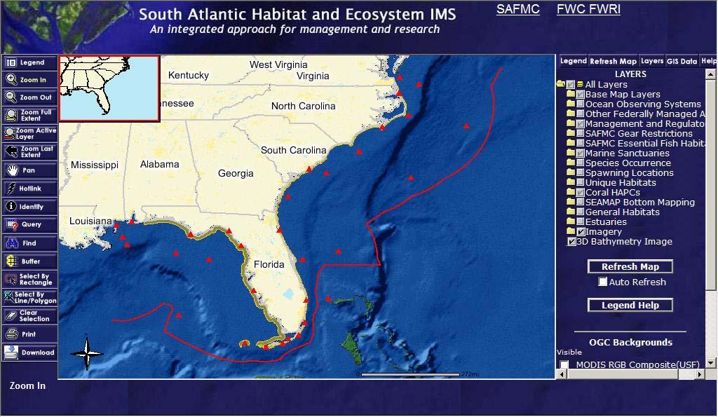
6 IMS Page


7 Phase 2 Consolidate related fisheries and habitat data for the South Atlantic region in a Web enabled environment Design and develop a framework for the Comprehensive Habitat and Fishery Ecosystem Plan home page Iterative process for establishing layout and taxonomy Traditional HTML and JavaScript


8 Software and Hardware Web Server for ArcIMS application Web Design Software Macromedia Dreamweaver Document Conversion - High Speed Scanner

9


10 Phase 3 Transition HTML homepage to a database driven Portal application Transition HTML homepage to a database driven Portal application Provide user groups and administrators security based roles Implement file sharing and uploading

11 Before After
 Modular Design easily")

12 Portal Software Open Source product : DotNetNuke built on a Microsoft ASP.NET platform SQL Server backend (can also use MySQL) Modular Design easily add modules for contacts, calendar of events, discussions, forums, FAQs, links, image galleries, etc. Web-based interface for anytime, anywhere updates
 to incorporate EcoGIS products into the")

13 Phase 4 EcoResearch EcoSpecies EcoFish Coordination with Tim Haverland (NOAA EcoGIS project Leader) to incorporate EcoGIS products into the IMS. Coordination with Ocean Exploration and University of North Carolina- Wilmington staff to integrate relevant SEADESC products in the IMS.


14 Phase 5 Advance the developing prototype EcoSpecies section of the Habitat and Ecosystem site. Supplement the South Atlantic EcoResearch database of relevant ecosystem research in the South Atlantic region. Transition to ArcGIS Server.
15 Client Browser FWRI Server Configuration Client Browser Client Browser Reverse Proxy Server Web ArcGIS (SOM, SOC) Server ArcServer: Dual Xeon/Dual Core 3.0 GHz (8Gb) ArcIMS Server (internal) OCEAN Xeon 2.4 GHz (2Gb) SDE / SQL 2005 Server GLEASON: Client Browser WWW DMZ Secure Internal Network
Geospatial Decision Support Tools for Planning of Marine Protected Areas in California
 Geospatial Decision Support Tools for Planning of Marine Protected Areas in California WILL MCCLINTOCK (UNIVERSITY OF CALIFORNIA SANTA BARBARA), MATT MERRIFIELD (THE NATURE CONSERVANCY), SOPHIE DE BEUKELAER
GEOGRAPHIC INFORMATION SYSTEMS AND IT SOLUTIONS FOR THE ENVIRONMENT
 GEOGRAPHIC INFORMATION SYSTEMS AND IT SOLUTIONS FOR THE ENVIRONMENT Mission We focus on Solutions is a worldwide operating business offering Geographic Information Systems and IT solutions to assist environmental
Lesser Sunda - Banda Seascape Atlas
 Lesser Sunda - Banda Seascape Atlas Report prepared for the development of online interactive map for Lesser Sunda Banda Seascape by WorldFish December 2014 http://sbsatlas.reefbase.org Page 1 of 8 Table
Sister Sanctuaries: Linking the Science and Management of Coral Reefs in Cuba and the U.S.
 Sister Sanctuaries: Linking the Science and Management of Coral Reefs in Cuba and the U.S. Memorandum of Understanding on Cooperation in the Conservation and Management of Marine Protected Areas Seventh
Northwestern Hawaiian Islands Coral Reef Research Partnership: Ocean Mapping, Ecosystem Threats, and Information Management
 Northwestern Hawaiian Islands Coral Reef Research Partnership: Ocean Mapping, Ecosystem Threats, and Information Management Malia Chow Papahanaumokuakea Marine National Monument National Oceanic and Atmospheric
Introduction: The Gulf of Mexico Alliance. The Gulf GAME project MERMAid and PHINS Results & Conclusions What s next? Examples
 AAG Las Vegas March 25, 2009 Introduction: Ocean governance and Ecosystem-Based Management The Gulf of Mexico Alliance Habitat Identification and Characterization The Gulf GAME project MERMAid and PHINS
GERSVIEW: A New Database for Web Mapping
 GERSVIEW: A New Database for Web Mapping William J. Hernández, M.S. Graduate Student Department of Marine Sciences-UPRM Fernando Gilbes, Ph.D. Associate Professor Department of Geology-UPRM Overview Introduction
Coastal Response Research Center. Nancy Kinner University of New Hampshire (UNH) Michele Jacobi NOAA ORR. September 27, 2007
 Michele Jacobi NOAA ORR. September 27, 2007") Coastal Response Research Center Nancy Kinner University of New Hampshire (UNH) Michele Jacobi NOAA ORR September 27, 2007 1 Coastal Response Research Center (CRRC) CRRC is partnership between NOAA s Office
Coastal Response Research Center Nancy Kinner University of New Hampshire (UNH) Michele Jacobi NOAA ORR September 27, 2007 1 Coastal Response Research Center (CRRC) CRRC is partnership between NOAA s Office
Alexandra Carvalho, Ph.D., GISP Kathy Fitzpatrick, P.E.
 Coastal Data Organization for Project Management and Coastal Planning Martin County, Florida Alexandra Carvalho, Ph.D., GISP Kathy Fitzpatrick, P.E. Outline County Coastal Programs Coastal Geodatabase
Environmental Response Management Application
 Environmental Response Management Application Coastal Response Research Center Nancy Kinner, Michele Jacobi, Rob Braswell, Kurt Schwehr & Amy Merten RRT III May 14, 2008 1 Talk Outline Overview of Center
UNIVERSITI TEKNOLOGI MARA
 UNIVERSITI TEKNOLOGI MARA GEO IMS (GEOMATICS INVENTORY MANAGEMENT SYSTEM) NIK NUR IZZATIE BINTI ABDUL HADI Thesis submitted in fulfillment of the requirements for the degree of Bachelor Science of Geomatics
Marine Spatial Planning: A Tool for Implementing Ecosystem-Based Management
 Marine Spatial Planning: A Tool for Implementing Ecosystem-Based Management Steven Murawski, Ph.D., Ecosystem Goal Team Lead National Oceanic and Atmospheric Administration NOAA November 16, 2009 1 To
OCEANOGRAPHIC DATA MANAGEMENT
 OCEANOGRAPHIC DATA MANAGEMENT Presented to: Environmental Disaster Data Management Meeting Russ Beard Director, National Coastal Data Development Center Interim Science Coordinator, Gulf Restoration Council
University of New Hampshire Scholars' Repository
 University of New Hampshire University of New Hampshire Scholars' Repository Center for Coastal and Ocean Mapping Center for Coastal and Ocean Mapping 3-2009 Environmental Response Management Application
Integrated application of Land Surveying and Mappipng. Data on Web-GIS
 Integrated application of Land Surveying and Mappipng Data on Web-GIS Abstract The data system of the land surveying and drawing is the core of the land information system. It includes the following contents:
Why GIS & Why Internet GIS?
 Why GIS & Why Internet GIS? The Internet bandwagon Internet mapping (e.g., MapQuest) Location-based services Real-time navigation (e.g., traffic) Real-time service dispatch Business Intelligence Spatial
Geographic Response Plan Mapping and Digital Area Contingency Plan
 Geographic Response Plan Mapping and Digital Area Contingency Plan Ryan Druyor Digital ACP Coordinator Florida Fish and Wildlife Conservation Commission Fish and Wildlife Research Institute Background
A Comparison of the Social Valuation of Ecosystem Services in Urban and Rural Contexts
 A Comparison of the Social Valuation of Ecosystem Services in Urban and Rural Contexts Jarrod L. Loerzel College of Charleston Zachary D. Cole University of Florida Presentation Map 1. What is SolVES?
SOUTHEAST OCEAN AND COASTAL ACIDIFICATION NETWORK. Scott Noakes, University of Georgia 2:00pm 2:30pm
 SOUTHEAST OCEAN AND COASTAL ACIDIFICATION NETWORK Scott Noakes, University of Georgia 2:00pm 2:30pm Agenda Overview of SOCAN SOCAN Mission Statement SOCAN Steering Committee SOCAN Executive Committee State
Joanne N. Halls, PhD Dept. of Geography & Geology David Kirk Information Technology Services
 Joanne N. Halls, PhD Dept. of Geography & Geology David Kirk Information Technology Services Geographic Information Systems manage and analyze data to solve spatial problems. Real World Abstraction Analysis
Imagery and the Location-enabled Platform in State and Local Government
 Imagery and the Location-enabled Platform in State and Local Government Fred Limp, Director, CAST Jim Farley, Vice President, Leica Geosystems Oracle Spatial Users Group Denver, March 10, 2005 TM TM Discussion
Discovery and Access of Geospatial Resources using the Geoportal Extension. Marten Hogeweg Geoportal Extension Product Manager
 Discovery and Access of Geospatial Resources using the Geoportal Extension Marten Hogeweg Geoportal Extension Product Manager DISCOVERY AND ACCESS USING THE GEOPORTAL EXTENSION Geospatial Data Is Very
An Arctic Perspective NCEI's Prototype Arctic Data Viewer
 An Arctic Perspective NCEI's Prototype Arctic Data Viewer NCEI Arctic Action Team Kate Rose NOAA National Environmental Satellite, Data, and Information Service National Centers for Environmental Information
NOAA s OCM: Services, tools and collaboration opportunities & Puerto Rico s NE Marine Corridor as a case study
 NOAA s OCM: Services, tools and collaboration opportunities & Puerto Rico s NE Marine Corridor as a case study Dr. Antares Ramos Álvarez NOAA s Office of Coastal Management September 15 th, 2016 Conservation
SW Florida Escarpment Mapping Area
 Overview NOAA s Okeanos Explorer (EX) Program plans to conduct systematic mapping and telepresence-enabled ROV explorations in the Gulf of Mexico during Spring 2014. In 2011, the EX conducted mapping operations
Introduction to Portal for ArcGIS. Hao LEE November 12, 2015
 Introduction to Portal for ArcGIS Hao LEE November 12, 2015 Agenda Web GIS pattern Product overview Installation and deployment Security and groups Configuration options Portal for ArcGIS + ArcGIS for
Marine Transportation and Ocean Use
 Marine Transportation and Ocean Use Data Needs for Multi-Disciplinary Long-Term Planning 4 th Biennial TRB-CMTS Research and Development Conference Matt Campo Rutgers University 6/22/2016 Overview What
Write a report (6-7 pages, double space) on some examples of Internet Applications. You can choose only ONE of the following application areas:
 on some examples of Internet Applications. You can choose only ONE of the following application areas:") UPR 6905 Internet GIS Homework 1 Yong Hong Guo September 9, 2008 Write a report (6-7 pages, double space) on some examples of Internet Applications. You can choose only ONE of the following application
UPR 6905 Internet GIS Homework 1 Yong Hong Guo September 9, 2008 Write a report (6-7 pages, double space) on some examples of Internet Applications. You can choose only ONE of the following application
Marine Spatial Data for Marine Spatial Planning. Ocean Leadership 2010 Public Policy Forum
 Marine Spatial Data for Marine Spatial Planning Ocean Leadership 2010 Public Policy Forum March 10, 2010 Edward Saade President, Fugro EarthData, Inc 1 Marine Spatial Data What is Marine Spatial Data?
MALDIVES. Regional Expert Workshop On Land Accounting For SDG Monitoring & Reporting (25-27 th Sept 2017) - Fathimath Shanna, Aishath Aniya -
 - Fathimath Shanna, Aishath Aniya -") MALDIVES Regional Expert Workshop On Land Accounting For SDG Monitoring & Reporting (25-27 th Sept 2017) - Fathimath Shanna, Aishath Aniya - ABOUT MALDIVES Approximately 860 km long and 120 km wide Consists
MALDIVES Regional Expert Workshop On Land Accounting For SDG Monitoring & Reporting (25-27 th Sept 2017) - Fathimath Shanna, Aishath Aniya - ABOUT MALDIVES Approximately 860 km long and 120 km wide Consists
Introduction to Portal for ArcGIS
 Introduction to Portal for ArcGIS Derek Law Product Management March 10 th, 2015 Esri Developer Summit 2015 Agenda Web GIS pattern Product overview Installation and deployment Security and groups Configuration
Army Installation Geospatial Information and Services (IGI&S) Program Overview
 Program Overview") Army Installation Geospatial Information and Services (IGI&S) Program Overview Joshua Delmonico Geospatial Information Officer OACSIM IGI&S Program 703-602-2851 Joshua.Delmonico@hqda.army.mil 1of 11 221400
Army Installation Geospatial Information and Services (IGI&S) Program Overview Joshua Delmonico Geospatial Information Officer OACSIM IGI&S Program 703-602-2851 Joshua.Delmonico@hqda.army.mil 1of 11 221400
Portal for ArcGIS: An Introduction
 Portal for ArcGIS: An Introduction Derek Law Esri Product Management Esri UC 2014 Technical Workshop Agenda Web GIS pattern Product overview Installation and deployment Security and groups Configuration
Data Management for Algal Monitoring in the Gulf of Mexico
 Data Management for Algal Monitoring in the Gulf of Mexico Scott Cross NOAA National Oceanographic Data Center/ Coastal Data Development Center (NCDDC) Outline History Current & Future Directions Needs
Hurricanes Katrina and Rita created the largest natural disaster in American history
 Overview of the Road Home Program Hurricanes Katrina and Rita created the largest natural disaster in American history In Louisiana: 123,000 homes suffered major damage 82,000 rental properties suffered
Cobb County GIS: Beyond the Map
 Cobb County GIS: Beyond the Map Charles Fail Tim Scharff Cobb County GIS SERUG 2008 1 Topics Cobb GIS Overview The Early Years Enterprise GIS Transition Putting It Together Looking Ahead SERUG 2008 2 Cobb
GENERALIZATION IN THE NEW GENERATION OF GIS. Dan Lee ESRI, Inc. 380 New York Street Redlands, CA USA Fax:
 GENERALIZATION IN THE NEW GENERATION OF GIS Dan Lee ESRI, Inc. 380 New York Street Redlands, CA 92373 USA dlee@esri.com Fax: 909-793-5953 Abstract In the research and development of automated map generalization,
Information. Information Technology. Geographic. Services (GIS) 119 W Indiana Ave Deland, FL 32720
 119 W Indiana Ave Deland, FL 32720") Information Technology Geographic Information Services (GIS) 119 W Indiana Ave Deland, FL 32720 A GIS consists of 5 primary components: Hardware Software People Data Methods or Business Processes --- Hardware
Information Technology Geographic Information Services (GIS) 119 W Indiana Ave Deland, FL 32720 A GIS consists of 5 primary components: Hardware Software People Data Methods or Business Processes --- Hardware
The Geo Web: Enabling GIS on the Internet IT4GIS Keith T. Weber, GISP GIS Director ISU GIS Training and Research Center.
 The Geo Web: Enabling GIS on the Internet IT4GIS Keith T. Weber, GISP GIS Director ISU GIS Training and Research Center In the Beginning GIS was independent The GIS analyst or manager was typically a oneperson
INSPIRE implementation in the Turkish Ministry of Environment and Urbanization Producing and Publishing Environmental Data
 INSPIRE implementation in the Turkish Ministry of Environment and Urbanization Producing and Publishing Environmental Data Ezgi Sarmusak Urban Planner, MoEU Sibel Süer Toybıyık - Assistant Expert, MoEU
GEOGRAPHIC INFORMATION SYSTEMS (GIS) AT GERS LAB
 AT GERS LAB") GEOGRAPHIC INFORMATION SYSTEMS (GIS) AT GERS LAB Fernando Gilbes Santaella GERS Lab-Department of Geology University of Puerto Rico at Mayaguez fernando.gilbes@upr.edu Geological and Environmental Remote
GEOGRAPHIC INFORMATION SYSTEMS (GIS) AT GERS LAB Fernando Gilbes Santaella GERS Lab-Department of Geology University of Puerto Rico at Mayaguez fernando.gilbes@upr.edu Geological and Environmental Remote
These modules are covered with a brief information and practical in ArcGIS Software and open source software also like QGIS, ILWIS.
 Online GIS Training and training modules covered are: 1. ArcGIS, Analysis, Fundamentals and Implementation 2. ArcGIS Web Data Sharing 3. ArcGIS for Desktop 4. ArcGIS for Server These modules are covered
A Prototype of a Web Mapping System Architecture for the Arctic Region
 A Prototype of a Web Mapping System Architecture for the Arctic Region Han-Fang Tsai 1, Chih-Yuan Huang 2, and Steve Liang 3 GeoSensorWeb Laboratory, Department of Geomatics Engineering, University of
NOAA Seafloor Mapping in the Pacific Islands Region
 NOAA Seafloor Mapping in the Pacific Islands Region NOAA Coral Reef Ecosystem Division Pacific Island Fisheries Science Center Mission Statement Conduct research that provides scientific information and
Features and Benefits
 Autodesk LandXplorer Features and Benefits Use the Autodesk LandXplorer software family to help improve decision making, lower costs, view and share changes, and avoid the expense of creating physical
Geog 469 GIS Workshop. Managing Enterprise GIS Geodatabases
 Geog 469 GIS Workshop Managing Enterprise GIS Geodatabases Outline 1. Why is a geodatabase important for GIS? 2. What is the architecture of a geodatabase? 3. How can we compare and contrast three types
National Marine Sanctuary Program
 National Marine Sanctuary Program NMSP/USGS Joint Seabed Mapping Initiative: September 2004 AA National Ocean Service National Marine Sanctuaries Interim Report September 2004 Background: Since 2002,
Spatial Planning in Canada s Maritimes Region. Maritimes Region
 Spatial Planning in Canada s Maritimes Region Glen Herbert, Scott Coffen-Smout Smout,, and Tanya Koropatnick Oceans and Coastal Management Division Ecosystem Management Branch Fisheries and Oceans Canada
SCOTIA WEATHER SERVICES INC.
 SCOTIA WEATHER SERVICES INC. Mission To provide high quality, reliable valued-added environmental information services based on measured and modeled atmospheric, land and/or oceanographic physical parameters
Demystifying ArcGIS Online. Karen Lizcano Esri
 Demystifying ArcGIS Online Karen Lizcano Esri An Integrated Web GIS Platform Desktop Web Device Powered by Services Managed via Portal Access from any Device Portal Server Online Content and Services ArcGIS
Nord Stream 2 A story of gas pipelines and GIS technology from the start. Cécile Noverraz GIS Analyst
 Nord Stream 2 A story of gas pipelines and GIS technology from the start 30-10-2018 Cécile Noverraz GIS Analyst Presentation - Outline >Project Overview > Initial GIS Project Setup > Project Data > GIS
NATO Headquarters The Situation Center GIS experience.
 NATO Headquarters The Situation Center GIS experience. Abstract Recently, the dynamic capability of responding to a major world crisis with comprehensive in-depth information has become a crucial aspect
Biogeographic Assessments to Meet Local & Regional Management Needs
 Biogeographic Assessments to Meet Local & Regional Management Needs August 2012 / NCCOS / Center for Coastal Monitoring and Assessment Center for Coastal Fisheries and Habitat Research Chris Jeffrey Chris.Jeffrey@noaa.gov
Spatial Data Availability Energizes Florida s Citizens
 NASCIO 2016 Recognition Awards Nomination Spatial Data Availability Energizes Florida s Citizens State of Florida Agency for State Technology & Department of Environmental Protection Category: ICT Innovations
Introduction to ArcGIS Server Development
 Introduction to ArcGIS Server Development Kevin Deege,, Rob Burke, Kelly Hutchins, and Sathya Prasad ESRI Developer Summit 2008 1 Schedule Introduction to ArcGIS Server Rob and Kevin Questions Break 2:15
How does ArcGIS Server integrate into an Enterprise Environment? Willy Lynch Mining Industry Specialist ESRI, Denver, Colorado USA
 How does ArcGIS Server integrate into an Enterprise Environment? Willy Lynch Mining Industry Specialist ESRI, Denver, Colorado USA wlynch@esri.com ArcGIS Server Technology Transfer 1 Agenda Who is ESRI?
Web GIS in Agriculture Land Use, Crop Management and Planning. Kevin Knapp Bryan Baker, Phd.
 Web GIS in Agriculture Land Use, Crop Management and Planning Kevin Knapp Bryan Baker, Phd. Two Case Studies Two Custom Developed Web Applications Both Integrate different technologies Primary Requirement
Counter-trafficking Integrated Display System (CIDS): A GIS-Based Command & Control Environment for Coalition Nations
: A GIS-Based Command & Control Environment for Coalition Nations") 9 th International Command and Control Research and Technology Symposium Counter-trafficking Integrated Display System (CIDS): A GIS-Based Command & Control Environment for Coalition Nations Elizabeth
9 th International Command and Control Research and Technology Symposium Counter-trafficking Integrated Display System (CIDS): A GIS-Based Command & Control Environment for Coalition Nations Elizabeth
2007 / 2008 GeoNOVA Secretariat Annual Report
 2007 / 2008 GeoNOVA Secretariat Annual Report Prepared for: Assistant Deputy Minister and Deputy Minister of Service Nova Scotia and Municipal Relations BACKGROUND This report reflects GeoNOVA s ongoing
ArcGIS Earth for Enterprises DARRON PUSTAM ARCGIS EARTH CHRIS ANDREWS 3D
 ArcGIS Earth for Enterprises DARRON PUSTAM ARCGIS EARTH CHRIS ANDREWS 3D ArcGIS Earth is ArcGIS Earth is a lightweight globe desktop application that helps you explore any part of the world and investigate
an accessible interface to marine environmental data Russell Moffitt
 an accessible interface to marine environmental data Russell Moffitt The Atlas Project GOAL: To provide a single point of access to oceanographic and environmental data for use by marine resource researchers,
Incorporating ArcGIS Pro in your Curriculum
 AAG, Boston 2017 April 5, 2017 Incorporating ArcGIS Pro in your Curriculum Geri Miller Agenda Concerns Acknowledged Learning curve ArcGIS Pro does not have all the tools (perception) Licensing and offline
StreamStats: Delivering Streamflow Information to the Public. By Kernell Ries
 StreamStats: Delivering Streamflow Information to the Public By Kernell Ries U.S. Department of the Interior U.S. Geological Survey MD-DE-DC District 410-238-4317 kries@usgs.gov StreamStats Web Application
Innovation. The Push and Pull at ESRI. September Kevin Daugherty Cadastral/Land Records Industry Solutions Manager
 Innovation The Push and Pull at ESRI September 2004 Kevin Daugherty Cadastral/Land Records Industry Solutions Manager The Push and The Pull The Push is the information technology that drives research and
Overview. Project Background Project Approach: Content and Application Development Application Demonstration Future Developments
 Overview Project Background Project Approach: Content and Application Development Application Demonstration Future Developments Southeast Pressures: Continued Population Growth Transportation Corridors
Marine Spatial Planning, a Norwegian user case NSHC33
 Marine Spatial Planning, a Norwegian user case NSHC33 Marine Spatial Management Tool Support the marine spatial planning process with updated and reliable geospatial information Marine management is important
Overview. Everywhere. Over everything.
 Cadenza Desktop Cadenza Web Cadenza Mobile Cadenza Overview. Everywhere. Over everything. The ultimate GIS and reporting suite. Provide, analyze and report data efficiently. For desktop, web and mobile.
One platform for desktop, web and mobile
 One platform for desktop, web and mobile Search and filter Get access to all data thematically filter data in context factually and spatially as well as display it dynamically. Export a selection or send
ELF products in the ArcGIS platform
 ELF products in the ArcGIS platform Presentation to: Author: Date: NMO Summit 2016, Dublin, Ireland Clemens Portele 18 May 2016 The Building Blocks 18 May, 2016 More ELF users through affiliated platforms
What Would John Snow Do (Today)? Part 1
? Part 1") What Would John Snow Do (Today)? Part 1 Tanya Bigos and Derek Law @Tanyabigos @GIS_Bandit Thurs Oct 19 th, 2017 Outline Overview of the ArcGIS Platform Whiteboard discussion Summary Questions A Whole New
What Would John Snow Do (Today)? Part 1 Tanya Bigos and Derek Law @Tanyabigos @GIS_Bandit Thurs Oct 19 th, 2017 Outline Overview of the ArcGIS Platform Whiteboard discussion Summary Questions A Whole New
Information System as a Tool for Marine Spatial Planning The SmartSea Vision and a Prototype
 Information System as a Tool for Marine Spatial Planning The SmartSea Vision and a Prototype Ari Jolma Marine Research Centre Finnish Environment Institute May 10, 2017 ISESS 2017, Zadar, Croatia Contents
Cross walking to the New Coastal and Marine Ecological Classification Standard (CMECS)
") Cross walking to the New Coastal and Marine Ecological Classification Standard (CMECS) Mark Finkbeiner and Chris Robinson NOAA Coastal Services Center EBM Tools Webinar 16 May 2013 Outline What is CMECS
Cross walking to the New Coastal and Marine Ecological Classification Standard (CMECS) Mark Finkbeiner and Chris Robinson NOAA Coastal Services Center EBM Tools Webinar 16 May 2013 Outline What is CMECS
GIS-Based Sediment Quality Database for the St. Louis River Area of Concern (AOC): Overview Presentations and Demonstration
: Overview Presentations and Demonstration") GIS-Based Sediment Quality Database for the St. Louis River Area of Concern (AOC): Overview Presentations and Demonstration Judy L. Crane 1 and Dawn E. Smorong 2 1 Minnesota Pollution Control Agency, St.
GIS-Based Sediment Quality Database for the St. Louis River Area of Concern (AOC): Overview Presentations and Demonstration Judy L. Crane 1 and Dawn E. Smorong 2 1 Minnesota Pollution Control Agency, St.
Leveraging Web GIS: An Introduction to the ArcGIS portal
 Leveraging Web GIS: An Introduction to the ArcGIS portal Derek Law Product Management DLaw@esri.com Agenda Web GIS pattern Product overview Installation and deployment Configuration options Security options
The Emerging Role of Enterprise GIS in State Forest Agencies
 The Emerging Role of Enterprise GIS in State Forest Agencies Geographic Information System (GIS) A geographic information system (GIS) is a computer software system designed to capture, store, manipulate,
Getting Started with Community Maps
 Esri International User Conference San Diego, California Technical Workshops July 24, 2012 Getting Started with Community Maps Shane Matthews and Tamara Yoder Topics for this Session ArcGIS is a complete
Using GIS to Manage Worldwide Drilling Assets
 Using GIS to Manage Worldwide Drilling Assets A Case Study Using ESRI Technology to provide solutions to the Petroleum Industry. Anastasia Aourik, GIS Consultant Smith International, Inc. 2008 ESRI Petroleum
Working with ArcGIS Online
 Esri International User Conference San Diego, CA Technical Workshops July 12, 2011 Working with ArcGIS Online Bern Szukalski, Deane Kensok Topics for this Session ArcGIS Online Overview ArcGIS Online Content
Development of a Web-Based GIS Management System for Agricultural Authorities in Iraq
 Development of a Web-Based GIS Management System for Agricultural Authorities in Iraq USCID Water Management Conference Phoenix, Arizona April 18, 2013 Gabriele Bonaiti Extension Program Specialist David
European Commission STUDY ON INTERIM EVALUATION OF EUROPEAN MARINE OBSERVATION AND DATA NETWORK. Executive Summary
 European Commission STUDY ON INTERIM EVALUATION OF EUROPEAN MARINE OBSERVATION AND DATA NETWORK Executive Summary by NILOS Netherlands Institute for the Law of the Sea June 2011 Page ii Study on Interim
Geospatial Fire Behavior Modeling App to Manage Wildfire Risk Online. Kenyatta BaRaKa Jackson US Forest Service - Consultant
 Geospatial Fire Behavior Modeling App to Manage Wildfire Risk Online Kenyatta BaRaKa Jackson US Forest Service - Consultant Fire Behavior Modeling and Forest Fuel Management Modeling Fire Behavior is an
Assessing, Monitoring, and Defending Coral Reefs with GIS
 Assessing, Monitoring, and Defending Coral Reefs with GIS Dr. Rich Snow and Dr. Mary Snow Applied Aviation Sciences Embry-Riddle Aeronautical University Daytona Beach, Florida It is estimated that 60%
Building an Enterprise GIS for Chicago s Water Reclamation District
 Building an Enterprise GIS for Chicago s Water Reclamation District Presenters Presented at the 2010 ESRI User Conference Authored and Presented By Sanjay Patel, PE, CEM, CMRP Metropolitan Water Reclamation
Creation of an Internet Based Indiana Water Quality Atlas (IWQA)
") Department of Environmental Management Creation of an Internet Based Water Quality Atlas (IWQA) May 4, 2005 IUPUI 1200 Waterway Blvd., Suite 100 polis, 46202-5140 Water Quality Atlas John Buechler, Neil
Department of Environmental Management Creation of an Internet Based Water Quality Atlas (IWQA) May 4, 2005 IUPUI 1200 Waterway Blvd., Suite 100 polis, 46202-5140 Water Quality Atlas John Buechler, Neil
Capturing a Holistic Understanding of a Large Marine Ecosystem The NOAA Gulf of Mexico Data Atlas
 Capturing a Holistic Understanding of a Large Marine Ecosystem The NOAA Gulf of Mexico Data Atlas NODC / National Coastal Data Development Center gulfalas.noaa.gov Need: data that contribute to long-term
9.0 Consistency with the Magnuson-Stevens Fishery Conservation and Management Act (MSFCMA)
") 9.0 Consistency with the Magnuson-Stevens Fishery Conservation and Management Act (MSFCMA) This analysis was prepared in accordance with the requirements of the Magnuson- Stevens Fishery Conservation and
9.0 Consistency with the Magnuson-Stevens Fishery Conservation and Management Act (MSFCMA) This analysis was prepared in accordance with the requirements of the Magnuson- Stevens Fishery Conservation and
ICAN Great Lakes 2010 Workshop
 ICAN Great Lakes 2010 Workshop Chris Cortina Maryland s Chesapeake & Coastal Program MD Department of Natural Resources Maryland s Coastal Atlas: What is it? The Coastal Atlas is an online mapping and
SITMUN: Cooperating to Build Local SDIs in the Barcelona Region
 SITMUN: Cooperating to Build Local SDIs in the Barcelona Region Diputació de Barcelona Territory and Sustainability Area Territorial Information Systems Department INSPIRE CONFERENCE Barcelona, September
STATEMENT OF CAPABILITY
 BELIZE MARINE CONSERVATION AND CLIMATE ADAPTATION PROJECT (MCCAP) Ministry of Forestry, Fisheries and Sustainable Development STATEMENT OF CAPABILITY Consultant for the Realignment of Boundaries and the
An Internet-Based Integrated Resource Management System (IRMS)
") An Internet-Based Integrated Resource Management System (IRMS) Third Quarter Report, Year II 4/1/2000 6/30/2000 Prepared for Missouri Department of Natural Resources Missouri Department of Conservation
An Internet-Based Integrated Resource Management System (IRMS) Third Quarter Report, Year II 4/1/2000 6/30/2000 Prepared for Missouri Department of Natural Resources Missouri Department of Conservation
A TOOLKIT FOR MARINE SPATIAL PLANNING Version: 17 July, 2009
 A TOOLKIT FOR MARINE SPATIAL PLANNING Version: 17 July, 2009 NEED FOR MARINE SPATIAL PLANNING The health of marine ecosystems is declining, and use conflicts in the marine environment are increasing, in
National Survey on the Natural Environment of Japan. Hajime Hirosawa Biodiversity Center of Japan Ministry of the Environment (MOE)
") National Survey on the Natural Environment of Japan Hajime Hirosawa Biodiversity Center of Japan Ministry of the Environment (MOE) Biodiversity Center of Japan, MOE Establishment: 1998 Purpose: to encourage
National Survey on the Natural Environment of Japan Hajime Hirosawa Biodiversity Center of Japan Ministry of the Environment (MOE) Biodiversity Center of Japan, MOE Establishment: 1998 Purpose: to encourage
MARCO s Mapping and Planning Portal. Coastal Geotools 2011 Special Interest Meeting-CMSP Portals & Atlases March 21, 2011 Jay Odell
 MARCO s Mapping and Planning Portal Coastal Geotools 2011 Special Interest Meeting-CMSP Portals & Atlases March 21, 2011 Jay Odell Overview What is a Portal? Description and demo of Mapping and Planning
Designing Networks of Marine Protected Areas in DFO s Three Atlantic Bioregions
 Designing Networks of Marine Protected Areas in DFO s Three Atlantic Bioregions Presentation for Indigenous Protected Areas Workshop Max Westhead, DFO and Adrian Gerhartz-Abraham, Dalhousie March 29, 2017
Corporate. Information. Railway Infrastructure Administrator. Year indracompany.com
 geospatial and mobility Corporate Geographic Information System of ADIF Railway Infrastructure Administrator. Year 2009-2010 Corporate Geographic Information System of ADIF ADIF. Spanish Administrator
Marine Ecology Pacing Guide
 Marine Ecology Pacing Guide Course Description: The focus of the course is the interrelationships among marine organisms and the physical, chemical, geological and biological factors. North Carolina coastal
SCAUG Community Maps Building a Living Atlas of the World
 SCAUG Community Maps Building a Living Atlas of the World Mark Stewart Topics: SCAUG ArcGIS Online Overview Community Maps Overview Community Maps Workflow Update Process Utilizing Your Contribution Community
TOWARDS CLIMATE-RESILIENT COASTAL MANAGEMENT: OPPORTUNITIES FOR IMPROVED ICZM IN BELIZE
 TOWARDS CLIMATE-RESILIENT COASTAL MANAGEMENT: OPPORTUNITIES FOR IMPROVED ICZM IN BELIZE CHANTALLE SAMUELS Coastal Zone Management Authority and Institute The Caribbean Community Climate Change Centre VULNERABILITY
Abstract. Introduction
 Southern California Aquaculture Site Assessment Model Caitlyn Raines University of Redlands Master of Science in Geographic Information Systems Program Abstract The Southern California Aquaculture Site
Options in Capacity Building. Underpinning the Blue Economy. Slide 1/78. Derrick R. Peyton. 14 th MACHC Meeting. IIC Technologies. December 9-13, 2013
 Options in Capacity Building Underpinning the Blue Economy Derrick R. Peyton IIC Technologies 14 th MACHC Meeting December 9-13, 2013 Slide 1/78 Overview Blue Economy Defined Challenges (SDI, MSDI, Standards)