Three Ways the CSU is Using Geographic Information Systems (GIS) to Inform Decisions
|
|
|
- Franklin Cox
- 5 years ago
- Views:
Transcription
1 Three Ways the CSU is Using Geographic Information Systems (GIS) to Inform Decisions Diana Lavery, Senior Research Analyst California State University, Office of the Chancellor California Association of Institutional Research 2016 Los Angeles, CA 16 November 2016
2 Has Anyone Used GIS?


3 Has Anyone Used GIS?
4 Has Anyone Used GIS? Has Anyone Used GIS for Institutional Research?
")

5 GIS and IR: Complementary A Geographic Information System (GIS) lets us Consider space and geography Display information visually See spatial patterns
6 Today s Presentation I. Foundation of GIS principles II. Three Case Studies 1. Commuting 2. Grant Support 3. Impaction III. Other Potential Applications, Discussion
7 FOUNDATION OF GIS
8 GIS Terminology Vector Data Point Line Polygon Attributes/Variables

9 GIS is a Public-Domain Environment Practitioners share files and data freely Gov t agencies make shapefiles available

10 Many GIS Software Packages Exist Maptitude ArcExplorer BusinessMAP Microsoft s MapPoint Esri s ArcGIS products ArcGIS for Desktop and ArcGIS Online
11 1) Commuting 2) Grant Support 3) Impaction 3 CASE STUDIES

12 1) Calculating Commuting Distances

13 1) Calculating Commuting Distances Distance Radii: 30 miles 50 miles

14 1) Calculating Commuting Distances Driving Distance Polygons 30 miles 50 miles

15 1) Calculating Commuting Distances Driving Time Polygons 15 minutes 30 minutes 45 minutes

16 Procedure in ArcGIS Online
17

18
19
20
21
22
23
24

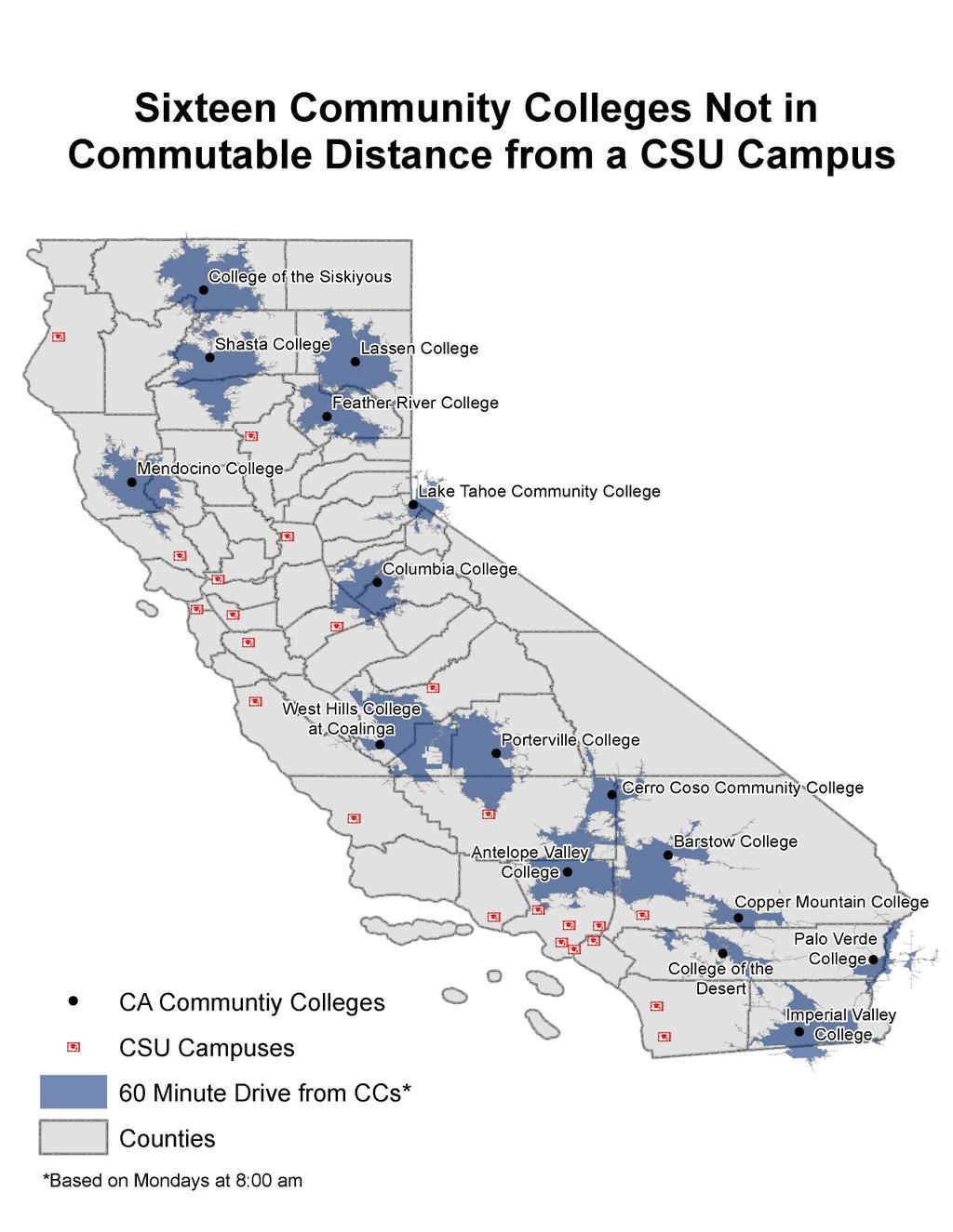
25 2) Identifying Campuses Eligible for Environmental Justice Grant

26 2) Identifying Campuses Eligible for Environmental Justice Grant Sustainability Programs inquired, We provide a benefit to environmentally disadvantaged communities! How can I show this in order to get grant money?
27 What Share of Our Students Come from These Communities?
28 Very Few Variables Needed Census Tract polygons: Tracts of interest from CalEPA All tracts from Census Bureau Institution of origin points: High schools & community colleges Enrollment Data
29 Step 1: Procedure in ArcGIS for Desktop
30
31
32
33
34

35

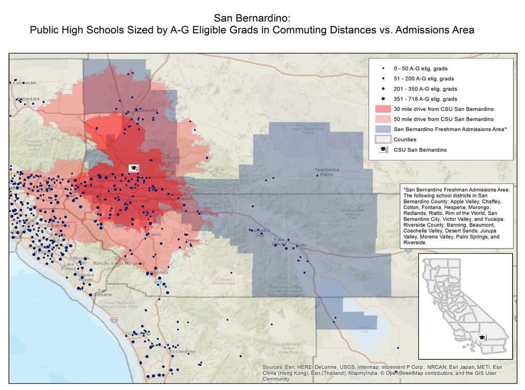
36
37

38

39

40 Whole Workflow Process Step 1 Step 2
41 Output to Sustainability Programs Office campus_name count percent Bakersfield Channel Islands Chico Dominguez Hills East Bay Fresno Fullerton Humboldt Long Beach Los Angeles Maritime Academy Monterey Bay Northridge Pomona Sacramento San Bernardino San Diego San Francisco San Jose San Luis Obispo San Marcos Sonoma Stanislaus
42 Output to Sustainability Programs Office campus_name count percent over_25pct_flag Bakersfield Channel Islands Chico Dominguez Hills East Bay Fresno Fullerton Humboldt Long Beach Los Angeles Maritime Academy Monterey Bay Northridge Pomona Sacramento San Bernardino San Diego San Francisco San Jose San Luis Obispo San Marcos Sonoma Stanislaus Some CSU campuses could apply for the environmental justice grant!

43 3) Examining Impaction and the High School & Community College Pipeline
44 3) Examining Impaction and the High School & Community College Pipeline Each impacted CSU set their own Local Admissions Area - boundaries based on either Major Roads Counties School Districts


45 Local Admissions Area Descriptions
46 How well are the Local Admissions Areas serving our students? How aligned are the Local Admissions Areas with potential commuting areas? How many A-G eligible high school grads are there within these Local Admissions Areas?
47 Pre-work: Gathering Data and Creating Shapefiles for Local Admissions Areas Local Admissions Area descriptions Shapefiles/Geography High School data Addresses A-G eligible graduates Potential Commuting Areas


48 Now We Have What We Need to Work Step 1: Translate description of Local Admissions Area into shapefiles Step 2: Compare to Potential Commuting Areas Step 3: Map high schools Step 4: Join A-G eligible numbers to high schools

49

50
51
52 3) Examining Impaction and the High School & Community College Pipeline Did this for all CSU campuses Looked at some racial and ethnic groups Used app/admit/enroll data by HS to get yield

53 MORE APPLICATIONS FOR IR
54 Many More Applications for IR Enrollment management/boundary definitions Considering locations for new off-campus centers Reach of distance learning programs Recruitment efforts (for both students & faculty) Identifying populations for grant opportunities Alumni/workforce patterns for teachers, nurses Good news: lots of IR data is already geographically referenced!
55 Thinking Spatially Use geographic information See spatial patterns
56 Thinking Spatially Use geographic information See spatial patterns Spatial modeling

57 Thinking Spatially Use geographic information See spatial patterns Spatial modeling Inform Decisions and Better Serve Students!
58 Other Applications in Your Work? Questions? Comments?

59 Contact Information Diana Lavery Senior Research Analyst California State University, Office of the Chancellor Analytic Studies (562)

60

61 APPENDIX
62 Resources and More Info for ArcGIS Coursera! tutorials, example maps, forums, trainings I recommend Standard level of ArcGIS for Desktop, Basic is really bare-bones and does not have functions that I use regularly. You can get a 60-day free trial at arcgis.com You probably already have a site-wide license through your Geography, Urban Planning, Earth Science, or Social Science Departments. If you do want to purchase it yourself, Esri usually gives discounts to public interest organizations, so worth asking about!
CRP 608 Winter 10 Class presentation February 04, Senior Research Associate Kirwan Institute for the Study of Race and Ethnicity
 CRP 608 Winter 10 Class presentation February 04, 2010 SAMIR GAMBHIR SAMIR GAMBHIR Senior Research Associate Kirwan Institute for the Study of Race and Ethnicity Background Kirwan Institute Our work Using
Demographic Data in ArcGIS. Harry J. Moore IV
 Demographic Data in ArcGIS Harry J. Moore IV Outline What is demographic data? Esri Demographic data - Real world examples with GIS - Redistricting - Emergency Preparedness - Economic Development Next
An Overview of Solving Spatial Problems Using ArcGIS
 Esri International User Conference San Diego, CA Technical Workshops An Overview of Solving Spatial Problems Using ArcGIS Linda Beale, Jian Lange July 12 th, 2011 Real World Example Using Spatial Analysis
Geographic Systems and Analysis
 Geographic Systems and Analysis New York University Robert F. Wagner Graduate School of Public Service Instructor Stephanie Rosoff Contact: stephanie.rosoff@nyu.edu Office hours: Mondays by appointment
GIS for the Beginner on a Budget
 GIS for the Beginner on a Budget Andre C. Bally, RLA, GIS Coordinator, Harris County Public Infrastructure Department Engineering Division This presentation, GIS for Beginners on a Budget. will briefly
SRJC Applied Technology 54A Introduction to GIS
 SRJC Applied Technology 54A Introduction to GIS Overview Lecture of Geographic Information Systems Fall 2004 Santa Rosa Junior College Presented By: Tim Pudoff, GIS Coordinator, County of Sonoma, Information
Joanne N. Halls, PhD Dept. of Geography & Geology David Kirk Information Technology Services
 Joanne N. Halls, PhD Dept. of Geography & Geology David Kirk Information Technology Services Geographic Information Systems manage and analyze data to solve spatial problems. Real World Abstraction Analysis
Evaluating Community Analyst for Use in School Demography Studies
 Portland State University PDXScholar Publications, Reports and Presentations Population Research Center 7-2013 Evaluating Community Analyst for Use in School Demography Studies Richard Lycan Portland State
WORKFORCE SERVICES DIRECTIVE. This policy officially identifies California s regional planning units.
 WORKFORCE SERVICES DIRECTIVE Attachment C Number: WSD15-17 Date: February 24, 2016 69:175:rc TO: WORKFORCE DEVELOPMENT COMMUNITY SUBJECT: CALIFORNIA WIOA REGIONAL PLANNING UNITS EXECUTIVE SUMMARY Purpose
Visualization of Commuter Flow Using CTPP Data and GIS
 Visualization of Commuter Flow Using CTPP Data and GIS Research & Analysis Department Southern California Association of Governments 2015 ESRI User Conference l July 23, 2015 l San Diego, CA Jung Seo,
SOUTH DAKOTA BOARD OF REGENTS. Academic and Student Affairs ******************************************************************************
 SOUTH DAKOTA BOARD OF REGENTS Academic and Student Affairs AGENDA ITEM: 7 C (4) DATE: June 28-30, 2016 ****************************************************************************** SUBJECT: New Minor:
ENV208/ENV508 Applied GIS. Week 1: What is GIS?
 ENV208/ENV508 Applied GIS Week 1: What is GIS? 1 WHAT IS GIS? A GIS integrates hardware, software, and data for capturing, managing, analyzing, and displaying all forms of geographically referenced information.
Geospatial Analysis of Job-Housing Mismatch Using ArcGIS and Python
 Geospatial Analysis of Job-Housing Mismatch Using ArcGIS and Python 2016 ESRI User Conference June 29, 2016 San Diego, CA Jung Seo, Frank Wen, Simon Choi and Tom Vo, Research & Analysis Southern California
ArcGIS Online Analytics. Mike Flanagan
 ArcGIS Online Analytics Mike Flanagan MFlanagan@esri.com Agenda Introduction to ArcGIS Online Spatial Analysis ArcGIS Online Spatial Analysis Workflow Demos and Examples Wrap-up Q&A ArcGIS A complete web
BROOKINGS May
 Appendix 1. Technical Methodology This study combines detailed data on transit systems, demographics, and employment to determine the accessibility of jobs via transit within and across the country s 100
KING FAHD UNIVERSITY OF PETROLEUM & MINERALS
 KING FAHD UNIVERSITY OF PETROLEUM & MINERALS Department of City & Regional Planning Introduction To GIS (CRP 514) Identifying & Planning Public School Facility In California Using GIS Presented to Dr.
Mapping Historical Information Using GIS
 Mapping Historical Information Using GIS David Yun, GISP Troy Lawson ABSTRACT The City of San Luis Obispo, California, is rich with history. It is one of California s oldest communities that began with
GIS Lecture 5: Spatial Data
 GIS Lecture 5: Spatial Data GIS 1 Outline Vector Data Formats Raster Data Formats Map Projections Coordinate Systems US Census geographic files US Census data files GIS Data Sources GIS 2 Vector Data Formats
Visualization of Origin- Destination Commuter Flow Using CTPP Data and ArcGIS
 Visualization of Origin- Destination Commuter Flow Using CTPP Data and ArcGIS Research & Analysis Department Southern California Association of Governments 2015 ESRI User Conference l July 23, 2015 l San
Population Density and Services In this lesson, students broaden their understanding of the ways water, landforms, vegetation, Lesson 4
 Lesson 4 Houses in San Diego Population Density and Services In this lesson, students broaden their understanding of the ways water, landforms, vegetation, and climate affect where people live and what
GED 554 IT & GIS. Lecture 6 Exercise 5. May 10, 2013
 GED 554 IT & GIS Lecture 6 Exercise 5 May 10, 2013 Free GIS data sources ******************* Mapping numerical data & Symbolization ******************* Exercise: Making maps for presentation GIS DATA SOFTWARE
Getting Started with Community Maps
 Esri International User Conference San Diego, California Technical Workshops July 24, 2012 Getting Started with Community Maps Shane Matthews and Tamara Yoder Topics for this Session ArcGIS is a complete
GIScience: Current Technology. Michael F. Goodchild University of California Santa Barbara
 GIScience: Current Technology Michael F. Goodchild University of California Santa Barbara What is a GIS? A class of software designed to handle geographic information and perform virtually any conceivable
Neighborhood social characteristics and chronic disease outcomes: does the geographic scale of neighborhood matter? Malia Jones
 Neighborhood social characteristics and chronic disease outcomes: does the geographic scale of neighborhood matter? Malia Jones Prepared for consideration for PAA 2013 Short Abstract Empirical research
Teaching GIS for Land Surveying
 Teaching GIS for Land Surveying Zhanjing (John) Yu Evergreen Valley College, San Jose, California James Crossfield California State University at Fresno, Fresno California 7/13/2006 1 Outline of the Presentation
Lecture 1 Introduction to GIS. Dr. Zhang Spring, 2017
 Lecture 1 Introduction to GIS Dr. Zhang Spring, 2017 Topics of the course Using and making maps Navigating GIS Map design Working with spatial data Geoprocessing Spatial data infrastructure Digitizing
Creating Basemaps to Manage Buildings and Facilities
 Esri International User Conference San Diego, California Technical Workshops July 26, 2012 Creating Basemaps to Manage Buildings and Facilities Mark Stewart and Tamara Yoder Topics for this Session Overview
Diving for Data: Using Demographics for Strategic Planning
 15 th Annual GOLD/GALILEO Users Group Conference Diving for Data: Using Demographics for Strategic Planning Presented by Marc Futterman, CIVICTechnologies maf@civictechnologies.com/888.606.7600 Copyright
Environmental Analysis, Chapter 4 Consequences, and Mitigation
 Environmental Analysis, Chapter 4 4.17 Environmental Justice This section summarizes the potential impacts described in Chapter 3, Transportation Impacts and Mitigation, and other sections of Chapter 4,
Work-Based Learning Definitions State Agencies
 Work-Based Learning Definitions State Agencies Using Geographic Information Systems to Support Equitable Work-Based Learning Planning and Implementation OVERVIEW AND RESOURCES By Trent Sharp from the College
Spatial Analysis in Your Browser
 Spatial Analysis in Your Browser Joseph Kerski Education Manager Esri jkerski@esri.com http://www.youtube.com/geographyuberalles Twitter http://twitter.com/josephkerski 303-449-7779 x 18237 Joseph Kerski
New Zealand Population Distribution
 New Zealand Population Distribution Requirements: Internet access Web browser (e.g. Internet Explorer, Mozilla Firefox, Google Chrome)** An Esri Global Account **Please insure that pop ups are not blocked
GIS 520 Data Cardinality. Joining Tabular Data to Spatial Data in ArcGIS
 GIS 520 Data Cardinality Joining Tabular Data to Spatial Data in ArcGIS Joining Tabular Data to Spatial Data in ArcGIS Outline Working with Zip Code Data Data Cardinality Issues Exploring Data Format Requirements
Rural Louisiana. A quarterly publication of the Louisiana Tech Rural Development Center
 Rural Louisiana A quarterly publication of the Louisiana Tech Rural Development Center Volume 4, No. 1, Fall 2009 Editor: Aaron K. Lusby Director, Asst. Professor Newsletter design: Stephanie Tidwell Student
Introduction to the 176A labs and ArcGIS Purpose of the labs
 Introduction to the 176A labs and ArcGIS Purpose of the labs Acknowledgement: Slides by David Maidment, U Texas-Austin and Francisco Olivera (TAMU) Hands-on experience with a leading software package Introduction
Faculty Disclosures Center for Health Research / Loma Linda University Pramil N. Singh, Dr.PH. No relevant commercial interests.
 Faculty Disclosures Center for Health Research / Loma Linda University Pramil N. Singh, Dr.PH No relevant commercial interests. Geographic Information Systems for Health Care Research, Practice, and Management
Empowering Local Health through GIS
 Empowering Local Health through GIS Mapping data from Washington s Immunization Information System (IIS). Presented to IACW October 16 th, 2013 by: Chris Halsell and Isaiah Berg Agenda IIS Overview Why
REPORT ON INVESTMENTS
 REPORT ON INVESTMENTS D.T2.3.3 Investments for technical equipment for the implementation of Web-GIS platform in Mantova 1 Local support group designing Mantova Web-GIS platform. Picture by Maria Giulia
GIS Boot Camp for Education June th, 2011 Day 1. Instructor: Sabah Jabbouri Phone: (253) x 4854 Office: TC 136
 x 4854 Office: TC 136") GIS Boot Camp for Education June 27-30 th, 2011 Day 1 Instructor: Sabah Jabbouri Phone: (253) 833-9111 x 4854 Office: TC 136 Email: sjabbouri@greenriver.edu http://www.instruction.greenriver.edu/gis/ Summer
GIS Boot Camp for Education June 27-30 th, 2011 Day 1 Instructor: Sabah Jabbouri Phone: (253) 833-9111 x 4854 Office: TC 136 Email: sjabbouri@greenriver.edu http://www.instruction.greenriver.edu/gis/ Summer
Techniques for Science Teachers: Using GIS in Science Classrooms.
 Techniques for Science Teachers: Using GIS in Science Classrooms. After ESRI, 2008 GIS A Geographic Information System A collection of computer hardware, software, and geographic data used together for
GIS in Response to Oil Spills and other Deleterious Materials
 GIS in Response to Oil Spills and other Deleterious Materials Judd Muskat California Department of Fish and Wildlife Office of Spill Prevention and Response What I Will Cover Office of Spill Prevention
Visualizing Census Data in GIS. Andrew Rowan, Ph.D. Director, NJ Office of GIS
 Visualizing Census Data in GIS Andrew Rowan, Ph.D. Director, NJ Office of GIS Outline VERY accelerated cartography primer Software choices Demos/how-to ArcGIS Desktop (formerly ArcView) ArcGIS Online Notes
GIS ADMINISTRATOR / WEB DEVELOPER EVANSVILLE-VANDERBURGH COUNTY AREA PLAN COMMISSION
 GIS ADMINISTRATOR / WEB DEVELOPER EVANSVILLE-VANDERBURGH COUNTY AREA PLAN COMMISSION SALARY RANGE INITIATION $43,277 SIX MONTHS $45,367 POSITION GRADE PAT VI The Evansville-Vanderburgh County Area Plan
GEOGRAPHIC INFORMATION SYSTEMS
 GEOGRAPHIC INFORMATION SYSTEMS 4-H Round-Up Community Transitions Workshop Daniel Hanselka June 14, 2011 Goals of the Workshop Answer the question: What is GIS? Uses of GIS. Some of the Common Terminology
Using Geographic Information Systems In Institutional Advancement Introduction
 Using Geographic Information Systems In Institutional Advancement Cynthia May, Assistant Professor of GIS Northland College in Ashland, Wisconsin June 2008 Introduction Today, hundreds of colleges and
Software requirements * :
 Title: Product Type: Developer: Target audience: Format: Software requirements * : Using GRACE to evaluate change in Greenland s ice sheet Part I: Download, import and map GRACE data Part II: View and
Valdosta State University Strategic Research & Analysis
 Christopher Neasbitt, Programmer Analyst Associate (cjneasbi@valdosta.edu) Kristina M. Cragg, Ph.D., Assistant to the President for Strategic Research & Analysis (kmcragg@valdosta.edu) Amir Atabekov, Student
Under a New Halo: Site Suitability Study for the Hypothetical Relocation of Angel Stadium. Jerry P. Magaña
 Under a New Halo: Site Suitability Study for the Hypothetical Relocation of Angel Stadium Jerry P. Magaña About me Relatively new to GIS and an honor to present at the 2017 UC Received Certificate in GIS
GIS Level 2. MIT GIS Services
 GIS Level 2 MIT GIS Services http://libraries.mit.edu/gis Email: gishelp@mit.edu TOOLS IN THIS WORKSHOP - Definition Queries - Create a new field in the attribute table - Field Calculator - Add XY Data
How is Your Health? Using SAS Macros, ODS Graphics, and GIS Mapping to Monitor Neighborhood and Small-Area Health Outcomes
 Paper 3214-2015 How is Your Health? Using SAS Macros, ODS Graphics, and GIS Mapping to Monitor Neighborhood and Small-Area Health Outcomes Roshni Shah, Santa Clara County Public Health Department ABSTRACT
STEREO ANALYST FOR ERDAS IMAGINE Stereo Feature Collection for the GIS Professional
 STEREO ANALYST FOR ERDAS IMAGINE Stereo Feature Collection for the GIS Professional STEREO ANALYST FOR ERDAS IMAGINE Has Your GIS Gone Flat? Hexagon Geospatial takes three-dimensional geographic imaging
How GIS based Visualizations Support Land Use and Transportation Modeling
 How GIS based Visualizations Support Land Use and Transportation Modeling ESRI International Users Conference San Diego, CA - July 23, 2015 Prepared by: Troy Hightower Introduction This presentation will
LEHMAN COLLEGE OF THE CITY UNIVERSITY OF NEW YORK. 1. Type of Change: Change in Degree Requirements
 Alpha Number: Hegis Code 1214 Program Code: 30600 1. Type of Change: Change in Degree Requirements 2. From: [The curriculum consists of 45 graduate credits and includes core courses, an area of specialization,
Introduction to the 176A labs and ArcGIS
 Introduction to the 176A labs and ArcGIS Acknowledgement: Slides by David Maidment, U Texas-Austin and Francisco Olivera (TAMU) Purpose of the labs Hands-on experience with one software pakage Introduction
Open Source Software Education in Texas
 Open Source Software Education in Texas PHILLIP DAVIS / RICHARD SMITH GEOACADEMY The Challenge for Open Source Adoption OPEN SOURCE Less the 5% of US colleges and universities offer training in Free and
Mapping Your Educational Research: Putting Spatial Concepts into Practice with GIS. Mark Hogrebe Washington University in St.
 Mapping Your Educational Research: Putting Spatial Concepts into Practice with GIS Mapping Your Educational Research: Putting Spatial Concepts into Practice with GIS Mark Hogrebe Washington University
Expanding Canada s Rail Network to Meet the Challenges of the Future
 Expanding Canada s Rail Network to Meet the Challenges of the Future Lesson Overview Rail may become a more popular mode of transportation in the future due to increased population, higher energy costs,
John Laznik 273 Delaplane Ave Newark, DE (302)
") Office Address: John Laznik 273 Delaplane Ave Newark, DE 19711 (302) 831-0479 Center for Applied Demography and Survey Research College of Human Services, Education and Public Policy University of Delaware
Office Address: John Laznik 273 Delaplane Ave Newark, DE 19711 (302) 831-0479 Center for Applied Demography and Survey Research College of Human Services, Education and Public Policy University of Delaware
Incorporating ArcGIS Pro in your Curriculum
 AAG, Boston 2017 April 5, 2017 Incorporating ArcGIS Pro in your Curriculum Geri Miller Agenda Concerns Acknowledged Learning curve ArcGIS Pro does not have all the tools (perception) Licensing and offline
Land-Use Land-Cover Change Detector
 15 th Esri India User Conference 2014 Land-Use Land-Cover Change Detector Rushikesh Padsala Email ID:- rushikesh101@gmail.com Student, III Semester, M.Tech Geomatics, Faculty of Technology, CEPT University
Digital Mapping as a Student and Staff Communication Tool. A Senior Project. presented to. the Faculty of Horticulture and Crop Science
 Digital Mapping as a Student and Staff Communication Tool A Senior Project presented to the Faculty of Horticulture and Crop Science California Polytechnic State University, San Luis Obispo In Partial
June 19 Huntsville, Alabama 1
 June 19 Huntsville, Alabama 1 Real-Time Geospatial Data: The Fusion of PI and ArcGIS Enabling Smarter Facilities Management OSIsoft and Esri Mapping and Location Analytics Platform Supporting Your Use
GIS FOR PLANNING. Course Overview. Schedule. Instructor. Prerequisites. Urban Planning 792 Thursday s 5:30-8:10pm SARUP 158
 GIS FOR PLANNING Urban Planning 792 Thursday s 5:30-8:10pm SARUP 158 Schedule Class/Lab - SARUP 158 Thursdays 5:30pm - 8:10pm Office Hours - By Appointment Project Ideas - Week 4 Final - 5/10/2018 Instructor
GIS Quick Facts. CIVL 1101 GIS Quick Facts 1/5.
 CIVL 1101 1/5 What is GIS? Geographic Information Systems (GIS) provide a platform for displaying and analyzing spatial data. GIS systems allow you to view multiple layers of data simultaneously. GIS is
Are You Maximizing The Value Of All Your Data?
 Are You Maximizing The Value Of All Your Data? Using The SAS Bridge for ESRI With ArcGIS Business Analyst In A Retail Market Analysis SAS and ESRI: Bringing GIS Mapping and SAS Data Together Presented
The National Hydrography Dataset in the Pacific Region. U.S. Department of the Interior U.S. Geological Survey
 The National Hydrography Dataset in the Pacific Region U.S. Department of the Interior U.S. Geological Survey The National Map The National Map is built on partnerships and standards The National Map consists
Geospatial Data Sources. SLO GIS User Group June 8, 2010
 Geospatial Data Sources SLO GIS User Group June 8, 2010 Presenters Drew Decker USGS Southern California Geospatial Liaison Kelly Bobbitt Mike Bobbitt & Associates Joe Larson Cal Fire Peter Meertens Regional
Human Physiology BIO 131. Physics A PHYS 5A
 California Community Colleges Biomechanics KINS 151, or KINS 151A, Exercise Physiology KINS 152, or KINS 150 Human Anatomy BIO 22 Human Physiology Allan Hancock College NO COMPARABLE NO COMPARABLE BIO
2018 ESRI Education Summit. San Diego. California. Sunday July 8 th 2018 Harper College, Palatine, Illinois, USA Dr. Tong Cheng (Biology), Dr.
, Dr.") 2018 ESRI Education Summit. San Diego. California. Sunday July 8 th 2018 Harper College, Palatine, Illinois, USA Dr. Tong Cheng (Biology), Dr. James Gramlich (Sociology), Mukila Maitha (Geography), Dr.
2018 ESRI Education Summit. San Diego. California. Sunday July 8 th 2018 Harper College, Palatine, Illinois, USA Dr. Tong Cheng (Biology), Dr. James Gramlich (Sociology), Mukila Maitha (Geography), Dr.
Gis 10 Training Manual
 Gis 10 Training Manual If you are searched for a ebook Gis 10 training manual in pdf format, then you have come on to right website. We presented full variation of this ebook in PDF, doc, epub, DjVu, txt
Information. Information Technology. Geographic. Services (GIS) 119 W Indiana Ave Deland, FL 32720
 119 W Indiana Ave Deland, FL 32720") Information Technology Geographic Information Services (GIS) 119 W Indiana Ave Deland, FL 32720 A GIS consists of 5 primary components: Hardware Software People Data Methods or Business Processes --- Hardware
Information Technology Geographic Information Services (GIS) 119 W Indiana Ave Deland, FL 32720 A GIS consists of 5 primary components: Hardware Software People Data Methods or Business Processes --- Hardware
Python Scripting for Regional Land Use Data Management and QC Workflow
 Python Scripting for Regional Land Use Data Management and QC Workflow 2015 ESRI User Conference July 21, 2015 San Diego, CA Jung Seo, Frank Wen, Simon Choi and Tom Vo Research & Analysis Southern California
Spatiotemporal Analysis of Commuting Patterns: Using ArcGIS and Big Data
 Spatiotemporal Analysis of Commuting Patterns: Using ArcGIS and Big Data 2017 ESRI User Conference July 13, 2017 San Diego, VA Jung Seo, Tom Vo, Frank Wen and Simon Choi Research & Analysis Southern California
Esri and GIS Education
 Esri and GIS Education Organizations Esri Users 1,200 National Government Agencies 11,500 States & Regional Agencies 30,800 Cities & Local Governments 32,000 Businesses 8,500 Utilities 12,600 NGOs 11,000
Speakers: Jeff Price, Federal Transit Administration Linda Young, Center for Neighborhood Technology Sofia Becker, Center for Neighborhood Technology
 Speakers: Jeff Price, Federal Transit Administration Linda Young, Center for Neighborhood Technology Sofia Becker, Center for Neighborhood Technology Peter Haas, Center for Neighborhood Technology Craig
Demographic Data. How to get it and how to use it (with caution) By Amber Keller
 By Amber Keller") Demographic Data How to get it and how to use it (with caution) By Amber Keller 101 Where does it come from? o The American Community Survey o Socio-economic characteristics of a population o Administered
Demographic Data How to get it and how to use it (with caution) By Amber Keller 101 Where does it come from? o The American Community Survey o Socio-economic characteristics of a population o Administered
New York City Public Use Microdata Areas (PUMAs) for 2010 Census
 for 2010 Census") New York City Public Use Microdata Areas (PUMAs) for 2010 Census ESRI Shapefile Tags PUMA, Public Use Microdata Area, Census, New York, Manhattan, Queens, Brooklyn, Richmond, Bronx, Kings, Staten Island,
New York City Public Use Microdata Areas (PUMAs) for 2010 Census ESRI Shapefile Tags PUMA, Public Use Microdata Area, Census, New York, Manhattan, Queens, Brooklyn, Richmond, Bronx, Kings, Staten Island,
Finding Common Ground Through GIS
 Finding Common Ground Through GIS Matthew Stone, MPH Special Unit for Technical Assistance Chronic Disease and Injury Control California Department of Public Health ESRI Health GIS Conference Scottsdale,
Census Transportation Planning Products (CTPP)
") Census Transportation Planning Products (CTPP) Penelope Weinberger CTPP Program Manager - AASHTO September 15, 2010 1 What is the CTPP Program Today? The CTPP is an umbrella program of data products, custom
Census Transportation Planning Products (CTPP) Penelope Weinberger CTPP Program Manager - AASHTO September 15, 2010 1 What is the CTPP Program Today? The CTPP is an umbrella program of data products, custom
Tuesday 6:30 9:30 (First/Last classes) Home Phone: SYLLABUS. I. Focus of Course
 Home Phone: SYLLABUS. I. Focus of Course") PSC 560-G Stephen Sherman GIS in Public Administration Political Science Dept. Summer, First Session, 2014 Work Phone: 373-4503 (Tue & Thur) Tuesday 6:30 9:30 (First/Last classes) Home Phone: 375-5328
PSC 560-G Stephen Sherman GIS in Public Administration Political Science Dept. Summer, First Session, 2014 Work Phone: 373-4503 (Tue & Thur) Tuesday 6:30 9:30 (First/Last classes) Home Phone: 375-5328
Institutional Research with Public Data and Open Source Software
 2017 Institutional Research with Public Data and Open Source Software DUE1304591, 1644409, 1700496 Opinions expressed are those of the authors and not necessarily those of the National Science Foundation.
Lab Assistant: Kathy Tang Office: SSC 2208 Phone: ext
 The University of Western Ontario Department of Geography GEOGRAPHY 9110B: Introduction to Geographic Information Systems Lecture: Thursday 11:30 1:30pm, SSC #1004 Lab: Thursday 2:30 4:30pm, SSC #1316A
Can Public Transport Infrastructure Relieve Spatial Mismatch?
 Can Public Transport Infrastructure Relieve Spatial Mismatch? Evidence from Recent Light Rail Extensions Kilian Heilmann University of California San Diego April 20, 2015 Motivation Paradox: Even though
GIS Education Activities in Detroit Public Schools Preparing Students for Careers in the Geospatial Industry A Multi-Agency Collaboration
 GIS Education Activities in Detroit Public Schools Preparing Students for Careers in the Geospatial Industry A Multi-Agency Collaboration Marsha A. Lewis, Social Studies Curriculum Specialist, Detroit
In this exercise we will learn how to use the analysis tools in ArcGIS with vector and raster data to further examine potential building sites.
 GIS Level 2 In the Introduction to GIS workshop we filtered data and visually examined it to determine where to potentially build a new mixed use facility. In order to get a low interest loan, the building
Introduction to Geographic Information Systems
 Introduction to Geographic Information Systems Lynn_Carlson@brown.edu 401-863-9917 The Environmental And Remote TecHnologies Lab MacMillan Hall, Room 105 http://www.brown.edu/research/earthlab/ Outline
Purpose Study conducted to determine the needs of the health care workforce related to GIS use, incorporation and training.
 GIS and Health Care: Educational Needs Assessment Cindy Gotz, MPH, CHES Janice Frates, Ph.D. Suzanne Wechsler, Ph.D. Departments of Health Care Administration & Geography California State University Long
State of California Department of Water Resources
 State of California Department of Water Resources NEW MANAGEMENT TOOLS FOR THE FLOODPLAIN MAPPING PROGRAM Prepared for the California Department of Water Resources Division of Flood Management Floodplain
WHAT YOU WILL LEARN TODAY
 WHAT YOU WILL LEARN TODAY Overview of the new QGIS Academy Curriculum Background on curriculum development Curriculum alignment with national standards Description of the five GIS courses Details of the
GIS Lecture 4: Data. GIS Tutorial, Third Edition GIS 1
 GIS Lecture 4: Data GIS 1 Outline Data Types, Tables, and Formats Geodatabase Tabular Joins Spatial Joins Field Calculator ArcCatalog Functions GIS 2 Data Types, Tables, Formats GIS 3 Directly Loadable
Presented at ESRI Education User Conference, July 6-8, 2001, San Diego, CA
 Presented at ESRI Education User Conference, July 6-8, 2001, San Diego, CA Irina V. Sharkova, Ph.D., Research Assistant Professor Richard Lycan, Ph.D., Senior Research Associate Population Research Center
Rural GIS Applications Geospatial Technology Awareness
 Rural GIS Applications Geospatial Technology Awareness Mike Rudibaugh, Ph.D. Co-PI NSF GeoTech Center Geography/GIS Instructor Lake Land College mrudibau@lakeland.cc.il.us 217-234-5244 What is the GeoTech
Wednesday 12 June 2013 Morning
 Wednesday 12 June 2013 Morning GCSE GEOGRAPHY B (and Short Course) B563/A772/01/02/RB Key Geographical Themes (Foundation and Higher Tier) RESOURCE BOOKLET *B522040613* INFORMATION FOR CANDIDATES The following
Arcmap Manual Esri 10 READ ONLINE
 Arcmap Manual Esri 10 READ ONLINE Esri Store: Browsing ArcPad 10.2.2 - ArcPad is mobile field mapping and data collection software designed for GIS professionals. It includes advanced GIS and GPS capabilities
Arcmap Manual Esri 10 READ ONLINE
 Arcmap Manual Esri 10 READ ONLINE If searching for a book Arcmap manual esri 10 in pdf form, then you have come on to the loyal site. We present the utter release of this book in PDF, doc, DjVu, epub,
Regional GIS Presentation for Small and Large Jurisdictions. Michelle E. Fults GIS Manager January 8, 2009
 Regional GIS Presentation for Small and Large Jurisdictions Michelle E. Fults GIS Manager January 8, 2009 Presentation Contributions from Juston Manville Henrico County Kevin Nelson Hanover County Mark
Benefits of GIS-Based Computer Inventories On the Texas A & M University Corpus Christi Campus. Cynthia and Christine Calamug
 Benefits of GIS-Based Computer Inventories On the Texas A & M University Corpus Christi Campus Cynthia and Christine Calamug ABSTRACT Texas A & M University Corpus Christi is located on an island with
What is GIS and How Can It Help Me?
 esri European User Conference Madrid 2011 What is GIS and How Can It Help Me? Jaime Nieves Ignacio Vázquez esri spain «Knowing where things are, and why, is essential to rational decision making.» Jack
THE PO L ITICS O F PL ACE-
 Your web browser (Safari 7) is out of date. For more security, comfort and the best experience on this site: Update your browser Ignore Activity Student Version THE PO L ITICS O F PL ACE- NAMING Why are
Michael Thomas Sullivan
 Michael Thomas Sullivan michael.sullivan2@lc.cuny.edu Home Address 2319 Brigham Street Brooklyn, NY 11229 Cell (516) 729-8870 Academic Address Geographic Information Science Dept. Lehman College, CUNY